3.0 panera minor subdivision application
TRANSCRIPT
CITY OF MISSOULA SUBDIVISION REGULATIONS SUPPLEMENTAL ADMINISTRATIVE MATERIALS – EXHIBITS JULY 11, 2014
1
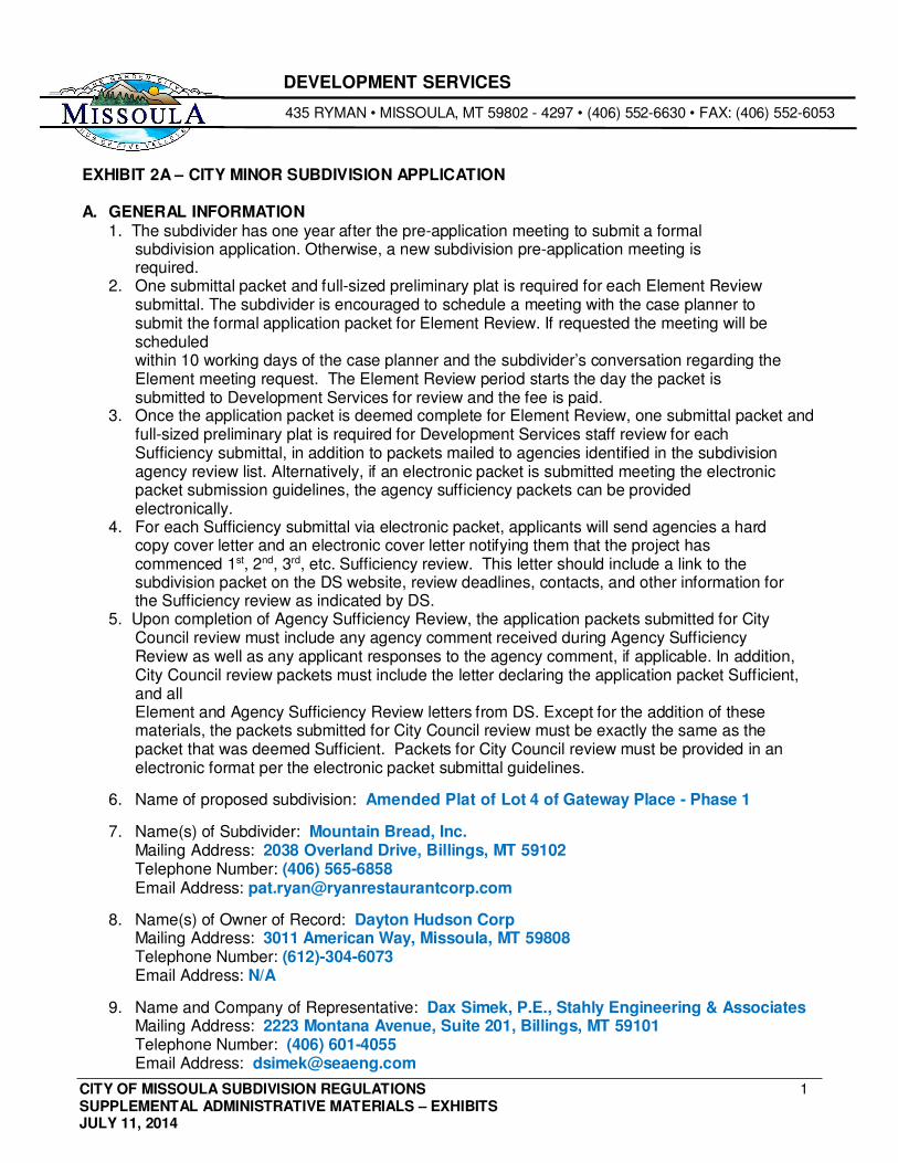
DEVELOPMENT SERVICES
435 RYMAN • MISSOULA, MT 59802 - 4297 • (406) 552-6630 • FAX: (406) 552-6053
EXHIBIT 2A – CITY MINOR SUBDIVISION APPLICATION
A. GENERAL INFORMATION 1. The subdivider has one year after the pre-application meeting to submit a formal
subdivision application. Otherwise, a new subdivision pre-application meeting is required.
2. One submittal packet and full-sized preliminary plat is required for each Element Review submittal. The subdivider is encouraged to schedule a meeting with the case planner to submit the formal application packet for Element Review. If requested the meeting will be scheduled within 10 working days of the case planner and the subdivider’s conversation regarding the Element meeting request. The Element Review period starts the day the packet is submitted to Development Services for review and the fee is paid.
3. Once the application packet is deemed complete for Element Review, one submittal packet and full-sized preliminary plat is required for Development Services staff review for each Sufficiency submittal, in addition to packets mailed to agencies identified in the subdivision agency review list. Alternatively, if an electronic packet is submitted meeting the electronic packet submission guidelines, the agency sufficiency packets can be provided electronically.
4. For each Sufficiency submittal via electronic packet, applicants will send agencies a hard copy cover letter and an electronic cover letter notifying them that the project has commenced 1st, 2nd, 3rd, etc. Sufficiency review. This letter should include a link to the subdivision packet on the DS website, review deadlines, contacts, and other information for the Sufficiency review as indicated by DS.
5. Upon completion of Agency Sufficiency Review, the application packets submitted for City Council review must include any agency comment received during Agency Sufficiency Review as well as any applicant responses to the agency comment, if applicable. In addition, City Council review packets must include the letter declaring the application packet Sufficient, and all Element and Agency Sufficiency Review letters from DS. Except for the addition of these materials, the packets submitted for City Council review must be exactly the same as the packet that was deemed Sufficient. Packets for City Council review must be provided in an electronic format per the electronic packet submittal guidelines.
6. Name of proposed subdivision: Amended Plat of Lot 4 of Gateway Place - Phase 1
7. Name(s) of Subdivider: Mountain Bread, Inc. Mailing Address: 2038 Overland Drive, Billings, MT 59102 Telephone Number: (406) 565-6858 Email Address: [email protected]
8. Name(s) of Owner of Record: Dayton Hudson Corp Mailing Address: 3011 American Way, Missoula, MT 59808 Telephone Number: (612)-304-6073 Email Address: N/A
9. Name and Company of Representative: Dax Simek, P.E., Stahly Engineering & Associates Mailing Address: 2223 Montana Avenue, Suite 201, Billings, MT 59101 Telephone Number: (406) 601-4055 Email Address: [email protected]
CITY OF MISSOULA SUBDIVISION REGULATIONS SUPPLEMENTAL ADMINISTRATIVE MATERIALS – EXHIBITS JULY 11, 2014
2
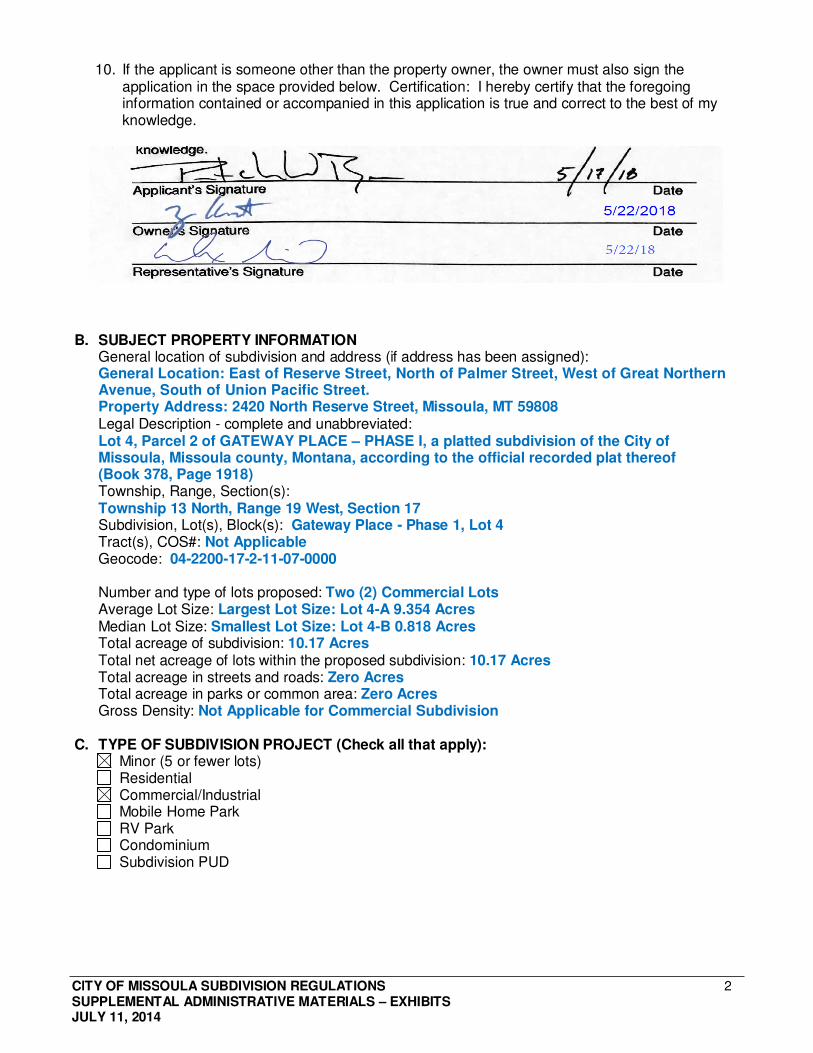
10. If the applicant is someone other than the property owner, the owner must also sign the application in the space provided below. Certification: I hereby certify that the foregoing information contained or accompanied in this application is true and correct to the best of my knowledge.
B. SUBJECT PROPERTY INFORMATION
General location of subdivision and address (if address has been assigned): General Location: East of Reserve Street, North of Palmer Street, West of Great Northern Avenue, South of Union Pacific Street. Property Address: 2420 North Reserve Street, Missoula, MT 59808 Legal Description - complete and unabbreviated: Lot 4, Parcel 2 of GATEWAY PLACE – PHASE I, a platted subdivision of the City of Missoula, Missoula county, Montana, according to the official recorded plat thereof (Book 378, Page 1918) Township, Range, Section(s): Township 13 North, Range 19 West, Section 17 Subdivision, Lot(s), Block(s): Gateway Place - Phase 1, Lot 4 Tract(s), COS#: Not Applicable Geocode: 04-2200-17-2-11-07-0000
Number and type of lots proposed: Two (2) Commercial Lots Average Lot Size: Largest Lot Size: Lot 4-A 9.354 Acres Median Lot Size: Smallest Lot Size: Lot 4-B 0.818 Acres Total acreage of subdivision: 10.17 Acres Total net acreage of lots within the proposed subdivision: 10.17 Acres Total acreage in streets and roads: Zero Acres Total acreage in parks or common area: Zero Acres Gross Density: Not Applicable for Commercial Subdivision
C. TYPE OF SUBDIVISION PROJECT (Check all that apply): Minor (5 or fewer lots) Residential Commercial/Industrial Mobile Home Park RV Park Condominium Subdivision PUD
CITY OF MISSOULA SUBDIVISION REGULATIONS SUPPLEMENTAL ADMINISTRATIVE MATERIALS – EXHIBITS JULY 11, 2014
3
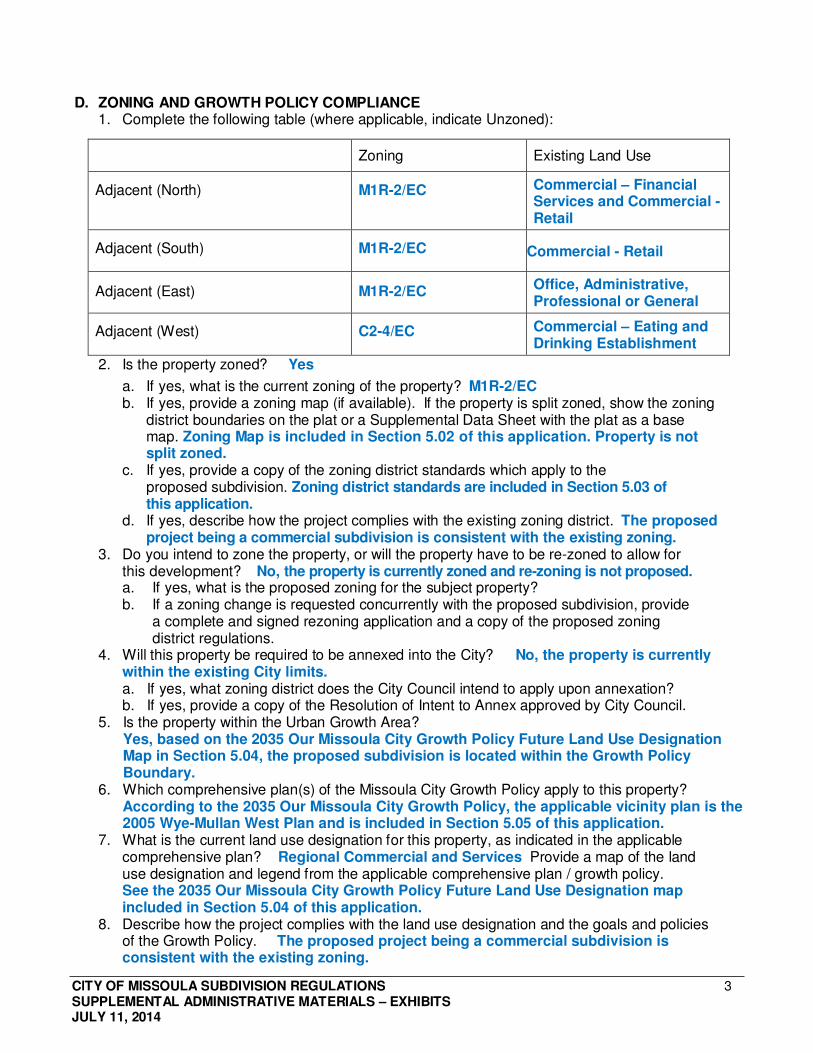
D. ZONING AND GROWTH POLICY COMPLIANCE 1. Complete the following table (where applicable, indicate Unzoned):
Zoning
Existing Land Use
Adjacent (North)
M1R-2/EC Commercial – Financial Services and Commercial - Retail
Adjacent (South)
M1R-2/EC Commercial - Retail
Adjacent (East)
M1R-2/EC Office, Administrative, Professional or General
Adjacent (West)
C2-4/EC Commercial – Eating and Drinking Establishment
2. Is the property zoned? Yes
a. If yes, what is the current zoning of the property? M1R-2/EC b. If yes, provide a zoning map (if available). If the property is split zoned, show the zoning
district boundaries on the plat or a Supplemental Data Sheet with the plat as a base map. Zoning Map is included in Section 5.02 of this application. Property is not split zoned.
c. If yes, provide a copy of the zoning district standards which apply to the proposed subdivision. Zoning district standards are included in Section 5.03 of this application.
d. If yes, describe how the project complies with the existing zoning district. The proposed project being a commercial subdivision is consistent with the existing zoning.
3. Do you intend to zone the property, or will the property have to be re-zoned to allow for this development? No, the property is currently zoned and re-zoning is not proposed. a. If yes, what is the proposed zoning for the subject property? b. If a zoning change is requested concurrently with the proposed subdivision, provide
a complete and signed rezoning application and a copy of the proposed zoning district regulations.
4. Will this property be required to be annexed into the City? No, the property is currently within the existing City limits. a. If yes, what zoning district does the City Council intend to apply upon annexation? b. If yes, provide a copy of the Resolution of Intent to Annex approved by City Council.
5. Is the property within the Urban Growth Area? Yes, based on the 2035 Our Missoula City Growth Policy Future Land Use Designation Map in Section 5.04, the proposed subdivision is located within the Growth Policy Boundary.
6. Which comprehensive plan(s) of the Missoula City Growth Policy apply to this property? According to the 2035 Our Missoula City Growth Policy, the applicable vicinity plan is the 2005 Wye-Mullan West Plan and is included in Section 5.05 of this application.
7. What is the current land use designation for this property, as indicated in the applicable comprehensive plan? Regional Commercial and Services Provide a map of the land use designation and legend from the applicable comprehensive plan / growth policy. See the 2035 Our Missoula City Growth Policy Future Land Use Designation map included in Section 5.04 of this application.
8. Describe how the project complies with the land use designation and the goals and policies of the Growth Policy. The proposed project being a commercial subdivision is consistent with the existing zoning.
CITY OF MISSOULA SUBDIVISION REGULATIONS SUPPLEMENTAL ADMINISTRATIVE MATERIALS – EXHIBITS JULY 11, 2014
4
9. Is a Planned Unit Development proposed? No If a Planned Unit Development is proposed, provide additional submittal requirements per Section 3-120.2.
E. CLUSTER AND CONSERVATION DEVELOPMENT 1. Is Cluster and Conservation Development per Section 3-180 proposed? No
a. If yes, provide additional submittal requirements described in Section 3-180.
F. PHASING 1. Is this subdivision proposed to be developed in phases? No
If yes, provide a phasing plan per Sections 4-070.2 & 4-070.3 (and optional Phasing Plan Narrative) which indicates the following: a. each phase of the subdivision numbered in the order in which they are proposed to be filed; b. which lots and which improvements will occur in each phase; c. a legend that lists each phase and the month, day and year that each phase will be
submitted for final plat review; and, d. the amount of parkland dedication required for each phase and the amount provided
for each phase. e. If the Phasing Plan is in color, also number each phase directly on the platted areas.
G. COVENANTS AND/OR HOMEOWNER’S ASSOCIATION 1. As a separate attachment, provide proposed draft covenants and restrictions to be included
in deeds and contracts for sale. No additional covenants or restrictions are proposed. 2. Is common property to be deeded to a property owner’s association? No
If common property is to be deeded, provide draft covenants and restrictions meeting minimum standards per Section 5-020.14K.
3. Are there existing or proposed covenants and/or a homeowner’s association? If yes, provide existing covenants, restrictions, and/or property owner’s or homeowner’s association documents or other documents that outline deed restrictions that apply to the subdivision. There are existing covenants and are included in Sections 4.3,4.4, and 4.5 of this application. If yes, the proposed draft covenants shall specify they apply to the proposed subdivision and are supplemental to the existing covenants and restrictions. Not applicable since there are no proposed additional covenants.
H. PROJECT SUMMARY As a separate attachment labeled "Project Summary" and included at the beginning of the submittal packet, provide a narrative description of the proposed project and existing site conditions. Summarize the following information:
• Owner; • Developer; • Representative name and company; • Subdivision name; • # of lots proposed; • # of acres;
• Legal description; • Summary of roads; • Summary of non-motorized facilities; • Variances requested, if any; and • Zoning & growth policy compliance
A Project Summary containing all of the information listed above is included in Section 2.1 of this application.
CITY OF MISSOULA SUBDIVISION REGULATIONS SUPPLEMENTAL ADMINISTRATIVE MATERIALS – EXHIBITS JULY 11, 2014
5
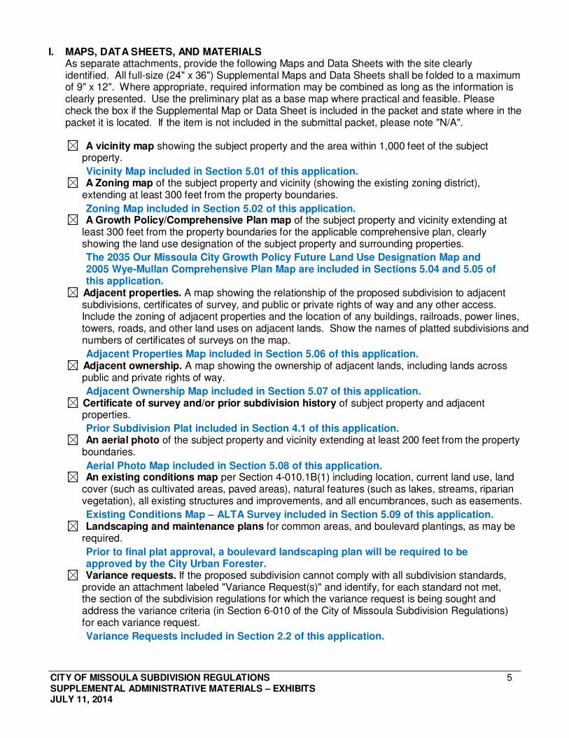
I. MAPS, DATA SHEETS, AND MATERIALS As separate attachments, provide the following Maps and Data Sheets with the site clearly identified. All full-size (24" x 36") Supplemental Maps and Data Sheets shall be folded to a maximum of 9" x 12". Where appropriate, required information may be combined as long as the information is clearly presented. Use the preliminary plat as a base map where practical and feasible. Please check the box if the Supplemental Map or Data Sheet is included in the packet and state where in the packet it is located. If the item is not included in the submittal packet, please note "N/A".
A vicinity map showing the subject property and the area within 1,000 feet of the subject property.
Vicinity Map included in Section 5.01 of this application. A Zoning map of the subject property and vicinity (showing the existing zoning district),
extending at least 300 feet from the property boundaries.
Zoning Map included in Section 5.02 of this application. A Growth Policy/Comprehensive Plan map of the subject property and vicinity extending at
least 300 feet from the property boundaries for the applicable comprehensive plan, clearly showing the land use designation of the subject property and surrounding properties.
The 2035 Our Missoula City Growth Policy Future Land Use Designation Map and 2005 Wye-Mullan Comprehensive Plan Map are included in Sections 5.04 and 5.05 of this application.
Adjacent properties. A map showing the relationship of the proposed subdivision to adjacent subdivisions, certificates of survey, and public or private rights of way and any other access. Include the zoning of adjacent properties and the location of any buildings, railroads, power lines, towers, roads, and other land uses on adjacent lands. Show the names of platted subdivisions and numbers of certificates of surveys on the map.
Adjacent Properties Map included in Section 5.06 of this application. Adjacent ownership. A map showing the ownership of adjacent lands, including lands across public and private rights of way.
Adjacent Ownership Map included in Section 5.07 of this application. Certificate of survey and/or prior subdivision history of subject property and adjacent properties.
Prior Subdivision Plat included in Section 4.1 of this application. An aerial photo of the subject property and vicinity extending at least 200 feet from the property
boundaries.
Aerial Photo Map included in Section 5.08 of this application. An existing conditions map per Section 4-010.1B(1) including location, current land use, land
cover (such as cultivated areas, paved areas), natural features (such as lakes, streams, riparian vegetation), all existing structures and improvements, and all encumbrances, such as easements.
Existing Conditions Map – ALTA Survey included in Section 5.09 of this application. Landscaping and maintenance plans for common areas, and boulevard plantings, as may be
required.
Prior to final plat approval, a boulevard landscaping plan will be required to be approved by the City Urban Forester. Variance requests. If the proposed subdivision cannot comply with all subdivision standards,
provide an attachment labeled "Variance Request(s)" and identify, for each standard not met, the section of the subdivision regulations for which the variance request is being sought and address the variance criteria (in Section 6-010 of the City of Missoula Subdivision Regulations) for each variance request.
Variance Requests included in Section 2.2 of this application.
CITY OF MISSOULA SUBDIVISION REGULATIONS SUPPLEMENTAL ADMINISTRATIVE MATERIALS – EXHIBITS JULY 11, 2014
6
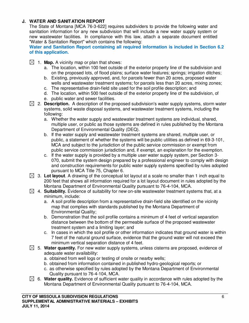
J. WATER AND SANITATION REPORT The State of Montana [MCA 76-3-622] requires subdividers to provide the following water and sanitation information for any new subdivision that will include a new water supply system or new wastewater facilities. In compliance with this law, attach a separate document entitled "Water & Sanitation Report" which contains the following: Water and Sanitation Report containing all required information is included in Section 6.2 of this application.
1. Map. A vicinity map or plan that shows: a. The location, within 100 feet outside of the exterior property line of the subdivision and
on the proposed lots, of flood plains; surface water features; springs; irrigation ditches; b. Existing, previously approved, and, for parcels fewer than 20 acres, proposed water
wells and wastewater treatment systems; for parcels less than 20 acres, mixing zones; c. The representative drain-field site used for the soil profile description; and d. The location, within 500 feet outside of the exterior property line of the subdivision, of e. public water and sewer facilities.
2. Description. A description of the proposed subdivision's water supply systems, storm water systems, solid waste disposal systems, and wastewater treatment systems, including the following: a. Whether the water supply and wastewater treatment systems are individual, shared,
multiple user, or public as those systems are defined in rules published by the Montana Department of Environmental Quality (DEQ).
b. If the water supply and wastewater treatment systems are shared, multiple user, or public, a statement of whether the systems will be public utilities as defined in 69-3-101, MCA and subject to the jurisdiction of the public service commission or exempt from public service commission jurisdiction and, if exempt, an explanation for the exemption.
c. If the water supply is provided by a multiple user water supply system, per Section 3- 070, submit the system design prepared by a professional engineer to comply with design and construction requirements for public water supply systems specified by rules adopted pursuant to MCA Title 75, Chapter 6.
3. Lot layout. A drawing of the conceptual lot layout at a scale no smaller than 1 inch equal to 200 feet that shows all information required for a lot layout document in rules adopted by the Montana Department of Environmental Quality pursuant to 76-4-104, MCA.
4. Suitability. Evidence of suitability for new on-site wastewater treatment systems that, at a minimum, include: a. A soil profile description from a representative drain-field site identified on the vicinity
map that complies with standards published by the Montana Department of Environmental Quality;
b. Demonstration that the soil profile contains a minimum of 4 feet of vertical separation distance between the bottom of the permeable surface of the proposed wastewater treatment system and a limiting layer; and
c. In cases in which the soil profile or other information indicates that ground water is within 7 feet of the natural ground surface, evidence that the ground water will not exceed the minimum vertical separation distance of 4 feet.
5. Water quantity. For new water supply systems, unless cisterns are proposed, evidence of adequate water availability: a. obtained from well logs or testing of onsite or nearby wells; b. obtained from information contained in published hydro-geological reports; or c. as otherwise specified by rules adopted by the Montana Department of Environmental
Quality pursuant to 76-4-104, MCA. 6. Water quality. Evidence of sufficient water quality in accordance with rules adopted by the
Montana Department of Environmental Quality pursuant to 76-4-104, MCA.
CITY OF MISSOULA SUBDIVISION REGULATIONS SUPPLEMENTAL ADMINISTRATIVE MATERIALS – EXHIBITS JULY 11, 2014
7
7. Impacts to groundwater quality. Preliminary analysis of potential impacts to ground water quality from new wastewater treatment systems, using as guidance rules adopted by the board of environmental review pursuant to 75-5-301, MCA and 75-5-303, MCA related to standard mixing zones for ground water, source specific mixing zones, and non-significant changes in water quality. The preliminary analysis may be based on currently available information and must consider the effects of overlapping mixing zones from proposed and existing wastewater treatment systems within and directly adjacent to the subdivision. Instead of performing the preliminary analysis, the sub-divider may perform a complete non- degradation analysis in the same manner as is required for an application that is reviewed under Title 76, Chapter 4.
K. PRIMARY REVIEW CRITERIA REPORT, SUMMARY OF PROBABLE IMPACTS, AND SUBDIVISION REGULATION COMPLIANCE (Montana Code Annotated (M.C.A. 76-3-603) does not require the submittal of an Environmental Assessment for minor subdivision proposals.)
1. IMPACT ON AGRICULTURE: Answer the questions below. In addition, provide a narrative that identifies the adverse impacts and describe proposed avoidance and mitigation efforts that will be used to reasonably minimize potentially significant adverse impacts to agriculture. Agricultural land includes land used for agriculture or having a soil type defined by the Natural Resources Conservation Service as having agricultural importance, including prime farmland, prime farmland if irrigated, farmland of statewide importance, and farmland of local importance.
Narrative Response: As determined below, the proposed project area is currently used for commercial development with no agricultural uses, thus there will be no adverse impacts and no avoidance or mitigation efforts are necessary to reasonably minimize potential adverse impacts on agriculture.
a. Agriculture production. Is the proposed subdivision located on land currently or previously used for agricultural production? No, the proposed subdivision is located on land that has been developed for urban, commercial development and the land has not been used for any agricultural production in the recent past history. If yes, identify the number of acres in production on a map.
b. Description. i. Describe the productivity of the land and whether the subdivision would remove from
production any agricultural or timber land. Not applicable since the existing use is commercial development.
ii. Describe agricultural operations and other uses of land on the adjacent property. The adjacent land uses are all commercial development with no agricultural operations.
iii. Describe what measures will be taken, if any, to control family pets. Not applicable due to the existing and proposed commercial use.
vi. Describe any existing fence lines around the subdivision boundary, which protect agricultural lands under an ownership other than that of the subdivider, and describe any measures which will be taken to ensure that the owners of the subdivision will share with the owner of the agricultural lands in the continued maintenance of the fence. Not applicable since there are no fence lines around the subdivision boundary, which protect agricultural lands.
CITY OF MISSOULA SUBDIVISION REGULATIONS SUPPLEMENTAL ADMINISTRATIVE MATERIALS – EXHIBITS JULY 11, 2014
8
c. Soil type. Is the proposed subdivision located on land with a soil type defined by the Natural Resources Conservation Services (NRCS) as having agricultural importance (Prime, Prime if Irrigated, Statewide or Local Importance)? Yes If yes, which type(s)? Prime if Irrigated i. Soils map. If yes, identify each area on a copy of the preliminary plat and provide a
Soils Map and Table from the Soil Survey, published by the U.S. Department of Agriculture, the Natural Resources Conservation Service, and the Forest Service, showing the soil type(s) found within the proposed subdivision. USDA NRCS Soil Resource Report is included in Section 5.10 of this application. The majority of the soil type located within the proposed subdivision is Grantsdale Loam, classified as prime farmland if irrigated.
ii. Soils assessment. Provide a soils assessment per Section 5-020.14M. A soils assessment is not applicable according to Section 5-020.14M. due to the proposed subdivision being commercial development.
iii. Sewer and zoning. If the soil type is defined as Prime or Prime if Irrigated, is the subdivision proposing or required to connect to sewer, or is the property unzoned? The proposed subdivision is currently served and proposed to be served by City sewer services. The property is currently zoned as M1R-2/EC.
iv. Irrigation. If the soil type is defined as Prime if Irrigated, is the property served by an existing, developed irrigation system or water right, including wells and adjacent irrigation ditches? The property is not served by an existing, developed irrigation system.
2. IMPACT ON AGRICULTURAL WATER USER FACILITIES: Answer the questions below. In addition, provide a narrative that identifies the adverse impacts and describe proposed avoidance and mitigation efforts that will be used to reasonably minimize potentially significant adverse impacts to agricultural water user facilities. Narrative Response: As determined below, the proposed project area is currently used for commercial development with no agricultural uses, thus there will be no adverse impacts and no avoidance or mitigation efforts are necessary to reasonably minimize potential adverse impacts on agricultural water user facilities.
a. Location. Is the subdivision located on land with agricultural water user facilities or adjoining an agricultural water user facility? No, the subdivision is not located on land with agricultural water user facilities or adjoining agricultural water user facilities. i. If yes, describe the facilities (irrigation ditch, well, etc.).
b. Ditches. Are any irrigation ditches located on or adjacent to the property? No, there are no irrigation ditches located on or adjacent to the property. i. If yes, provide the name and contact information for the responsible ditch company. ii. If yes, do you intend to provide access to the irrigation ditch for all lots?
1. If no, if the average lot size in the proposed subdivision will be one acre or less, provide for disclosure notifying potential buyers that lots within the subdivision are classified as irrigated land and may continue to be assessed for irrigation water delivery even though the water may not be deliverable to the lots.
c. Abandonment or transfer of water rights. Does the subdivision involve the abandonment or transfer of water rights from the property being subdivided? No, upon review of DNRC records, there are no apparent water rights, thus this subdivision will not involve the abandonment or transfer of water rights.
CITY OF MISSOULA SUBDIVISION REGULATIONS SUPPLEMENTAL ADMINISTRATIVE MATERIALS – EXHIBITS JULY 11, 2014
9
i. If yes, provide documentation that the water rights have either been removed from the land or that the process has been initiated to remove the water rights from the land.
ii. If yes, the fact the water rights have been or will be removed from the land within the subdivision shall be denoted on the preliminary plat.
iii. If no, the subdivider shall, unless otherwise provided under separate written agreement or filed easement, show on the preliminary plat, ditch easements for the unobstructed use and maintenance of existing water delivery ditches, pipelines, and facilities in the proposed subdivision that are necessary to convey water through the subdivision to lands adjacent to or beyond the subdivision boundaries in quantities and in a manner that are consistent with historic and legal rights. A minimum width of 10 feet is required on each side of irrigation ditch canals and ditches for maintenance purposes, unless a lesser width is agreed to by the owner of the ditch right. Not applicable since there are no apparent water rights and no existing irrigation facilities.
d. Removal of facilities. Does the subdivision involve the abandonment or removal of agricultural water user facilities? No, the subdivision does not involve the abandonment or removal of agricultural water user facilities.
e. Maintenance. Will the proposed subdivision or associated improvements alter access for maintenance of agricultural water user facilities? No, the proposed subdivision or associated improvements will not alter access for maintenance of agricultural water user facilities.
f. Water availability. Will the proposed subdivision or associated improvements alter the movement or availability of water? No, the proposed subdivision or associated improvements will not alter the movement or availability of water.
g. Disturbance. Will any proposed construction disturb an existing irrigation ditch or well or result in any changes to agricultural water use? No, proposed construction will not disturb an existing irrigation ditch or well or result in any changes to agricultural water use.
3. IMPACT ON NATURAL ENVIRONMENT: Answer the questions below. In addition, provide a narrative that identifies the adverse impacts and describe proposed avoidance and mitigation efforts that will be used to reasonably minimize potentially significant adverse impacts to the natural environment. Narrative Response: As determined below, the proposed project area is currently used for commercial development, thus there will be no adverse impacts and no avoidance or mitigation efforts are necessary to reasonably minimize potential adverse impacts to the natural environment.
a. Public lands i. Is the subdivision proposal adjacent to public lands? No, the subdivision is not
adjacent to public lands. 1. If yes, how will the proposed subdivision affect adjacent public land uses? 2. If yes, describe any applicable land management policies of any public lands
adjacent to or near the proposed subdivision. 3. If yes, describe how access to public lands will be affected by this subdivision.
CITY OF MISSOULA SUBDIVISION REGULATIONS SUPPLEMENTAL ADMINISTRATIVE MATERIALS – EXHIBITS JULY 11, 2014
10
b. Historical features i. Are there any known historic, paleontological, archaeological or cultural sites, structures
or objects on or within a half-mile of the proposed subdivision? Since this subdivision is existing commercial development there will be no impacts to any historic, paleontological, archaeological or cultural sites, structures or objects. 1. If yes, identify any known historical, paleontological, archaeological or cultural sites,
structures and/or objects within a half-mile of the proposed subdivision, provide a site map identifying these features which may be affected by the proposed subdivision and describe any plans to protect such sites or properties.
2. If yes, discuss the impact of the proposed development on any historic features, and the need for inventory, study and/or preservation with the State Historic Preservation Office (SHPO). Provide a written statement outlining any recommendations of SHPO and any plans for inventory, study and/or preservation and any mitigation planned to overcome any adverse impacts.
c. Water rights i. Have the water rights been severed from the subject property? Upon review of DNRC
records, there are no apparent water rights, thus water rights will not need to be severed from the subject property.
d. Groundwater i. Does high seasonal groundwater rise within 15 feet of the surface of the property? No, upon
review of the Montana Bureau of Mines and Geology – Ground Water Information center, the static water level near the proposed subdivision is approximately thirty (30) feet and is not anticipated to rise within fifteen (15) feet of the property.
1. When evidence of high groundwater or unstable soil is present, provide a groundwater drainage mitigation plan prepared by a licensed professional engineer to mitigate the problem. The plan shall include, but not be limited to, measures to prevent the migration of groundwater through water, sewer and drainage trenches.
ii. What are the maximum and minimum depths to the water table, and on what dates were those depths determined?
iii. What is the depth of aquifers and aquifer recharge areas from the surface of the property?
iv. Describe the steps necessary to avoid depletion or degradation of groundwater recharge areas.
e. Surface water i. Delineated floodplain. Is any portion of the property within a FEMA-designated 100-
year or Shaded Zone X floodplain? No portions of the property are located within a FEMA-designated 100- year or Shaded Zone X floodplain. The applicable Flood Insurance Rate Map is included in Section 5.11 of this application. 1. If any portion of the property is within a FEMA-designated 100-year or Shaded Zone
X floodplain, provide a map with a legend showing the designated areas, and/or areas removed by FEMA through a Letter of Map Amendment.
ii. Non-delineated floodplain. Are any proposed building sites within 20 vertical feet and 1,000 horizontal feet of a stream draining an area of 15 square miles or more and in the same drainage basin, in an area where no official floodway delineation or floodway study of the stream has been made (in accordance with 3-010.2A)? Not applicable since the subject project is not located in a non-delineated floodplain.

CITY OF MISSOULA SUBDIVISION REGULATIONS SUPPLEMENTAL ADMINISTRATIVE MATERIALS – EXHIBITS JULY 11, 2014
11
1. If any proposed building sites are within 20 vertical feet and 1,000 horizontal feet of a stream draining an area of 15 square miles or more and in the same drainage basin, in an area where no official floodway delineation or floodway study of the stream has been made (in accordance with Section 3-010.2A), submit a Flood Hazard Evaluation Report.
iii. Mapping. Locate on a plat overlay or sketch map all surface water and the delineated floodways that may affect or be affected by the proposed subdivision including natural water systems (streams, lakes, rivers, or marshes), artificial water systems (canals, ditches, aqueducts, reservoirs, irrigation or drainage systems), and land subject to flooding. There is no surface water near the proposed subdivision and the subdivision is not located within any delineated floodways, thus there will be no affects to natural or artificial water systems or lands subject to flooding. Aerial mapping and floodplain maps are included in this application showing non-existence of surface water.
iv. Description. Describe all surface water that may affect or be affected by the proposed subdivision including name, approximate size, present use, and time of year that water is present. Describe the proximity of proposed construction (such as buildings, sewer systems, and roads) to surface waters. There are no surface waters that may affect or be affected by the proposed subdivision.
v. Wetlands. If wetlands are present, the subdivider shall provide wetlands investigation completed by a qualified consultant using the U.S. Army Corps of Engineers’ Wetlands Delineation Manual Technical Report Y-87-1 (1987 Manual). If the investigation indicates the presence of wetlands, a wetlands delineation shall be shown on the final plat. If any construction or changes are proposed which require a 404 Permit, the subdivider shall provide evidence of such permit to the planning department. There are no wetlands present and located within the proposed subdivision.
vi. Water quality. Please indicate which if any of the following water quality permits have been applied for and describe the reasons why these permits are required: None of the following water quality permits are anticipated for this project. 1. 310 Permit (Local Conservation District) 2. SPA 124 Permit (Department of Fish, Wildlife, and Parks) 3. Floodplain Permit (City Floodplain Administrator) 4. Section 404 Permit, Section 10 Permit (U.S. Army Corps of Engineers) 5. 318 Authorization (Department of Environmental Quality) 6. Navigable Rivers Land Use License or Easement (Department of Natural Resources
and Conservation)
f. Vegetation and Riparian Resource Areas i. Plant types. Describe the vegetative types by plant community, relative age, and
condition. The vegetation that exists on the subject property consists of urban landscaping composed of irrigated lawn grass and ornamental shade trees within an asphalt parking lot. The planting age is approximately 20 years based on prior subdivision and the existing plantings are in very good condition.
CITY OF MISSOULA SUBDIVISION REGULATIONS SUPPLEMENTAL ADMINISTRATIVE MATERIALS – EXHIBITS JULY 11, 2014
12
ii. Measures to preserve existing vegetation. Describe any measures that will be taken to preserve trees and other natural vegetation as much as possible (such as locating roads, lot boundaries, and planning of construction to avoid damaging tree cover). The existing irrigated grass boulevards with trees on Reserve Street and Palmer Street will not be disturbed. Site development may require the removal and replacement of four (4) small parking lot curb islands. All new construction will be subject to building permitting with the City of Missoula and subject to zoning and landscaping requirements.
iii. Critical plant communities. Describe measures that will be taken to protect critical plant communities (such as keeping structural development away from these areas, and setting aside areas for open space). There are no identified critical plant communities that will be affected by the proposed subdivision.
iv. Weeds. Identify areas containing noxious weed growth. Describe proposed means of weed control, especially means to prevent weed growth on areas disturbed by construction. Upon a site review, there are no identified noxious weeds on the subject property. All areas disturbed during construction will be promptly revegetated or stabilized according to City building permitting requirement and the property restrictive covenants.
v. Wetlands and riparian resource areas. Are there any wetland and/or riparian resource areas on the property per Section 2-020.102? There are no apparent wetland or riparian resource areas on the property. 1. If Riparian Resource Areas are within or adjacent to the proposed subdivision,
provide a Riparian Management Plan per the submittal requirements in Sections 3- 130.3 and 5-020.14L. Show areas of riparian resource and proposed buffers on a supplemental data sheet.
vi. Map. Provide a map showing the distribution of the vegetation types (such as existing trees, vegetation clusters, marsh, grassland, shrub, coniferous forest, deciduous forest, mixed forest) and critical plant communities such as stream bank or shoreline vegetation, vegetation on steep or unstable slopes, vegetation on soils highly susceptible to wind or water erosion. An aerial photo showing the existing vegetation types is included in Section 5.08 of this application.
g. Geology / Hydrology / Soils / Slopes
i. Description. Describe the geologic, soil, or topographic conditions and any measures that will be taken to address potential problems encountered in the construction of roadways, basements, water supply trenches, sewer supply trenches, septic tank and drainfield installation, and/or underground electrical and telephone lines. No potential geologic, soil or topographic problems are expected to be encountered during construction. Standard construction practices for utility installation and building construction are expected to be sufficient for the anticipated soil conditions.
ii. Cut and fill. Describe the location and amount of any cut or fill three (3) or more feet in depth and plans to prevent erosion and promote revegetation of those cuts and fills. No cuts or fills three (3) feet or more are anticipated for this project.
CITY OF MISSOULA SUBDIVISION REGULATIONS SUPPLEMENTAL ADMINISTRATIVE MATERIALS – EXHIBITS JULY 11, 2014
13
iii. U.S.G.S. topographic map. Provide a detailed current U.S. Geological Survey topographic map with an outline of the subdivision clearly indicated. A USGS topographical map is included Section 5.12 of this application.
iv. Limitations map. Provide a Geologic / Topographic Limitations Map which locates any unusual geologic, soil, or topographic condition on the property which may limit the capability for building or excavation using ordinary and reasonable construction techniques. Conditions include, but are not limited to: shallow depths to bedrock, depth to aquifers and aquifer recharge areas (source: Montana Bureau of Mines and Geology Groundwater Information Center - GWIC), basin closures (Source: Department of Natural Resources, Missoula Regional Office), a high groundwater table, unstable or expansive soils, and slopes in excess of 25%. No unusual geologic, soil or topographic conditions are evident that may limit development on the project site. The project area is surrounded by established commercial development with streets and buildings with no known issues.
v. Geotechnical report. If the proposed subdivision includes land areas with the potential for landsliding, slope instability, or high ground water, provide a report by a qualified soil or geotechnical engineer indicating the locations, character, and extent of all areas subject to landsliding, slope instability, and high ground water, and prominently designate these areas on the preliminary plat and other records of conveyance. The proposed subdivision is located in an area or existing commercial development and there is no evidence or known areas with potential for landsliding, slope instability or high groundwater.
vi. Steep Slopes/Slope category map. Does the subject property have slopes of 25% or greater? No, the subject property does not include any slopes of 25% or greater. 1. If yes, designate these areas as "No-Build Zone/Steep Slope" on the plat.
vii. Hillside density adjustment calculation worksheet. If the subdivision has sites proposed for development located on slopes over fifteen (15) percent, submit a hillside report per the requirements in Section 5-020.14E and a density adjustment calculation worksheet per the requirements in Section 3-140.4. A hillside density adjustment calculation worksheet is available at the Development Services Office. This subdivision does not have sites proposed for development located on slopes over fifteen (15) percent.
4. IMPACTS ON WILDLIFE AND WILDLIFE HABITAT: Answer the questions below. In addition, provide a narrative that identifies the adverse impacts and describe proposed avoidance and mitigation efforts that will be used to reasonably minimize potentially significant adverse impacts to wildlife and wildlife habitat. Narrative Response: As determined below, the proposed project area is currently used for commercial development, thus there will be no adverse impacts and no avoidance or mitigation efforts are necessary to reasonably minimize potentially significant adverse impacts to wildlife and wildlife habitat.
a. Species types. Per Montana Fish, Wildlife, and Parks maps and data, which species of fish and wildlife use the area to be affected by the subdivision? Wildlife in the area is limited to miscellaneous smaller mammals and birds due to the presence of urbanization and lack of significant cover.
CITY OF MISSOULA SUBDIVISION REGULATIONS SUPPLEMENTAL ADMINISTRATIVE MATERIALS – EXHIBITS JULY 11, 2014
14
b. Wildlife mitigation. i. Describe any proposed measures to protect, enhance, or minimize degradation of wildlife
habitat (such as keeping buildings and roads back from shorelines, setting aside marshland as open space, using a cluster development to limit development on sensitive areas). Due to the lack of any wildlife habitat, no mitigation measures are proposed to protect, enhance or minimize degradation of wildlife habitat.
ii. Describe any proposed measures to minimize or mitigate conflicts between residents and wildlife (such as covenants that require garbage and pet food to be kept indoors). Not applicable since this is a commercial subdivision. Further, the restrictive covenants include provisions for trash containment and unreasonable nuisances.
c. Map. Provide a map identifying any known critical or key wildlife areas such as big game winter ranges, grizzly bear linkage corridors, waterfowl nesting areas, habitat for rare or endangered species, and wetlands and riparian resource areas per Montana Fish, Wildlife, and Park’s maps and data and other appropriate resources. Due to the presence of existing commercial development, this project does not include any known critical or key wildlife areas.
5. IMPACTS ON PUBLIC HEALTH & SAFETY: Answer the questions below. In addition, provide a narrative that identifies the adverse impacts and describe proposed avoidance and mitigation efforts that will be used to reasonably minimize potentially significant adverse impacts to public health and safety. Narrative Response: As determined below, the proposed project area is currently used for commercial development, thus there will be no adverse impacts and no avoidance or mitigation efforts are necessary to reasonably minimize potentially significant adverse impacts to public health and safety.
a. Air Stagnation Zone. Is the property within the Air Stagnation Zone? The property is included in the Air Stagnation Zone, the Missoula County Air Stagnation Zone Map is included in Section 5.13 of this application. Due to the existing development and the delineation Air Stagnation Zone completely covering the City of Missoula, this project will not cause any additional air stagnation impacts.
b. Airport Influence Area. Is the property within the Airport Influence Area? The property is not within the Airport Influence Area, the Missoula County Airport Influence Area Map is included in Section 5.14 of this application. i. If the property is within the Airport Influence Area, provide a map showing the
boundaries of the Airport Influence Area with the site identified and other sub-areas (such as Runway Protection Zone (RPZ), Extended Approach and Departure Areas (EADA), and the 65 dnL noise contour).
c. Avoidance and mitigation of hazards. Describe avoidance or mitigation measures that are proposed to address identified hazard(s) and provide a map locating the hazards. Examples of health and safety hazards are: i. areas containing high pressure gas lines or high voltage lines;
There are no high pressure gas or high voltage lines on or near the property. Overhead power and underground communications utilities are located along Reserve Street and the proposed building site is located with sufficient distance to avoid any hazards.
ii. land on or adjacent to Superfund or hazardous waste sites; There are no apparent superfund or hazardous waste sites on or adjacent to the
CITY OF MISSOULA SUBDIVISION REGULATIONS SUPPLEMENTAL ADMINISTRATIVE MATERIALS – EXHIBITS JULY 11, 2014
15
proposed project. iii. land on or adjacent to abandoned landfills, mines, well, waste sites or sewage treatment
plants; and There are no apparent abandoned landfills, mines, well, waste sites or sewage treatment plants on or adjacent to the proposed project.
iv. areas identified as a high seismic hazard According to the Montana Bureau of Mines and Geology Quaternary Faults and Seismicity in Western Montana Map (special publication number 114), there are no high seismic hazard areas on or in the immediate vicinity of the proposed project.
d. Nuisances. If the proposed subdivision contains on-site or nearby off-site land uses that create a nuisance (such as noise, dust, smoke, or unpleasant odors), identify such nuisances and describe avoidance or mitigation measures that are being proposed to address them. The proposed subdivision does not contain any nuisances and the existing restrictive covenants prohibit unreasonable nuisances or disturbances. Reserve Street is located immediately to the west of this subdivision which is an arterial street for Missoula and the region with high traffic volumes. The amount of traffic can contribute to nuisances of noise and fumes. Mitigation measures to minimize impacts include adherence to City building standards and zoning, preserving the existing vegetative buffer and building siting. The presence of an arterial road is an essential component that contributes to commercial development and are thus the uses are considered compatible.
6. IMPACT ON LOCAL SERVICES: Answer the questions below. In addition, provide a narrative that identifies the adverse impacts and describe proposed avoidance and mitigation efforts that will be used to reasonably minimize potentially significant adverse impacts to local services.
Narrative Response: As determined below, the proposed project area is currently used for commercial development, thus there will be no adverse impacts and no avoidance or mitigation efforts are necessary to reasonably minimize potentially significant adverse impacts to local services.
a. Transportation facilities – motorized and non-motorized. Describe the proposed subdivision’s mitigation measures to avoid or minimize congestion (MCA 76-3-501(8)); The proposed subdivision is located directly adjacent to Reserve Street, a major transportation arterial in the greater Missoula area and is subject to heavy traffic congestion at limited times. Since this proposal is for one (1) additional commercial use in an existing heavily developed commercial area, this project is not considered to significantly contribute to the existing traffic volumes. Additionally, the presence of existing traffic signals and fully developed streets, prohibits the implementation of any mitigation measures.
i. Bridges and culverts. Describe characteristics such as location, name, type, width, design load, and vertical clearance, of any existing or proposed bridges or culverts within the subdivision or on roads providing access to the subdivision. There are no existing bridges or culverts present or proposed for this subdivision subdivision.
ii. Non-motorized transportation facilities. Describe existing and proposed non- motorized transportation facilities that will serve the proposed subdivision, including sidewalks and bike lanes/striping. The existing non-motorized transportation facilities include sidewalk on all streets surrounding the proposed subdivision and a striped bike lane on
CITY OF MISSOULA SUBDIVISION REGULATIONS SUPPLEMENTAL ADMINISTRATIVE MATERIALS – EXHIBITS JULY 11, 2014
16
Reserve and Palmer Streets. Due to the presence of existing non-motorized facilities on adjacent streets, no additional facilities are proposed that are needed to serve the proposed subdivision. Site development for this project will include internal lot pedestrian connectivity in accordance with the zoning requirements.
iii. Bus Routes. Provide a map showing the locations of any bus stops and turnarounds for school buses and public transit, or provide a narrative description of bus routes in lieu of a map. If the project is located on an existing school bus route, show the route and the nearest bus stop relative to the proposed subdivision. If a bus stop is proposed within the subdivision, indicate the type and location on a Supplemental Data Sheet. Bus stops for public transit are located on Reserve Street on the west side of the proposed project and on Great Northern Avenue on the east side of the project, no additional bus stops are proposed. The proposed subdivision does not include any bus turnarounds and none are proposed.
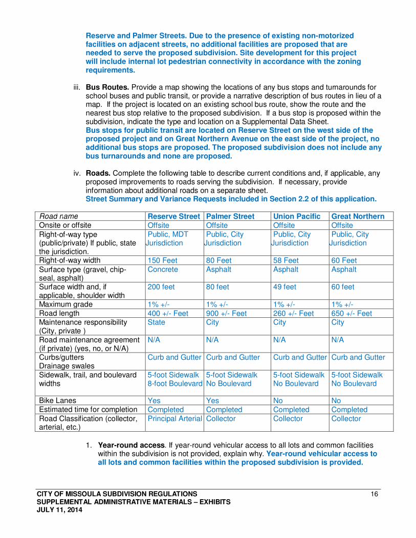
iv. Roads. Complete the following table to describe current conditions and, if applicable, any proposed improvements to roads serving the subdivision. If necessary, provide information about additional roads on a separate sheet. Street Summary and Variance Requests included in Section 2.2 of this application.
Road name Reserve Street Palmer Street Union Pacific Great Northern Onsite or offsite Offsite Offsite Offsite Offsite
Right-of-way type (public/private) If public, state the jurisdiction.
Public, MDT Jurisdiction
Public, City Jurisdiction
Public, City Jurisdiction
Public, City Jurisdiction
Right-of-way width 150 Feet 80 Feet 58 Feet 60 Feet
Surface type (gravel, chip- seal, asphalt)
Concrete Asphalt Asphalt Asphalt
Surface width and, if applicable, shoulder width
200 feet 80 feet 49 feet 60 feet
Maximum grade 1% +/- 1% +/- 1% +/- 1% +/- Road length 400 +/- Feet 900 +/- Feet 260 +/- Feet 650 +/- Feet Maintenance responsibility (City, private )
State City City City
Road maintenance agreement (if private) (yes, no, or N/A)
N/A N/A N/A N/A
Curbs/gutters Drainage swales
Curb and Gutter Curb and Gutter Curb and Gutter Curb and Gutter
Sidewalk, trail, and boulevard widths
5-foot Sidewalk 8-foot Boulevard
5-foot Sidewalk No Boulevard
5-foot Sidewalk No Boulevard
5-foot Sidewalk No Boulevard
Bike Lanes Yes Yes No No Estimated time for completion Completed Completed Completed Completed Road Classification (collector, arterial, etc.)
Principal Arterial Collector Collector Collector
1. Year-round access. If year-round vehicular access to all lots and common facilities within the subdivision is not provided, explain why. Year-round vehicular access to all lots and common facilities within the proposed subdivision is provided.
CITY OF MISSOULA SUBDIVISION REGULATIONS SUPPLEMENTAL ADMINISTRATIVE MATERIALS – EXHIBITS JULY 11, 2014
17
2. Arterial access. If access to any individual lot is directly from an arterial street or road, explain why access was not provided by means of a road with a lesser classification. No direct access to any individual lot from and arterial street is proposed for this subdivision.
3. Private road access. A. Does access to the property cross any private properties not owned by the
subdivider or property owner? No, all access to the property to be from dedicated streets or access easements on land owned by the subdivider and property owner according to a private access easement recorded under Book 378, Page 1986. If access to the subdivision is across private property not owned by the subdivider, provide a list labeled "Legal Access" containing the names and owners of those properties. Include documentation of perpetual legal access (including but not limited to easements, agreements, and access permits or other forms of access permission) or describe how perpetual legal access will be obtained prior to the filing of the final plat. The documentation must be sufficient to demonstrate perpetual legal access. The information must be provided for any access routes required.
B. Are private roads proposed? No private roads are proposed for this
subdivision. If private roads are proposed, include a private road maintenance plan in a development agreement or draft covenants.
C. Are short courts proposed? No short courts are proposed for this subdivision If short courts are proposed, provide a plan meeting the standards of Section 3-
020.6B and a variance request addressing the criteria in Section 6-010.
D. Are Homezone/Woonerf streets proposed? No Homezone or Woonerf streets are proposed for this subdivision If Homezone/Woonerfs are proposed, provide a plan meeting the standards of Section 3-020.7
E. Are Cul-de-sac/Circle/Loop streets proposed? No Cul-de-sacs, circles or loops are proposed for this subdivision. If Cul-de-sac/Circle/Loop streets are proposed, provide a plan meeting the standards of Section 3-020.5B and a variance request addressing the criteria in Section 6-010.
4. Traffic impact narrative: A. What is the expected increase in the number of automobile trips per day that the
proposed subdivision will generate? For traffic estimates, please reference the most recent edition of Trip Generation: An ITE Informational Report. Based on the ITE Trip Generation Manual 10th edition, the expected increase in the number of generated automobile trips per day is approximately 2,183 vehicles.
B. Identify all existing transportation corridors, (including bicycle and pedestrian routes) within a quarter-mile radius of the project and provide a summary describing how this project is likely to impact those transportation corridors.
C. What are the planned improvements to existing public and private access roads to mitigate the impacts anticipated from this subdivision?
CITY OF MISSOULA SUBDIVISION REGULATIONS SUPPLEMENTAL ADMINISTRATIVE MATERIALS – EXHIBITS JULY 11, 2014
18
5. Street and road plans, including at a minimum, the following information: A. Using the subdivision plat as a base map show the following:
i. Street names See Preliminary Plat and Section K.6.a.iv of this application.
ii. Right-of-way widths See Preliminary Plat and Section K.6.a.iv of this application.
iii. Surface widths See Section K.6.a.iv of this application.
iv. Street grades See Section K.6.a.iv of this application.
v. Type, width and location of sidewalks and curbs/gutters See Section K.6.a.iv of this application.
vi. Minimum site distances and curb radii at corners Reserve/Palmer – 160+/- sight distance, 45’ curb radii Reserve/Union Pacific - 115+/- sight distance, 35’(google)curb radii Union Pacific/Great Northern - 100+/- sight distance, 30’ curb radii Great Northern/Palmer - 120+/- sight distance, 40’ curb radii
vii. Locations and characteristics of bridges and culverts No bridges or culverts
viii. Location of street lights Reserve Street, Palmer Street, Great Northern Boulevard and Union Pacific Street all have existing street lighting.
ix. For cul-de-sac streets, provide the widths of turn-around radii, minimum right- of-way widths at turn-arounds, minimum surface widths at turn-arounds and total length Not Applicable, no cul-de-sac streets
x. Number and location of on-street parking spaces, if applicable It appears on street parking, along the full length of Great Northern Boulevard is allowed. The presence of bike lanes or narrow shoulder prohibit parking on the other streets, however, restrictive signage or pavement markings are not present.
xi. Bike lanes – existing or proposed. Bike lanes exist on Reserve and Palmer Streets, no additional bike lanes are proposed
B. Typical cross sections including pavement and base thickness for each type of proposed road or road improvement proposed within the subdivision and adjacent to the subdivision which serves the subdivision. Not applicable, no new roads or road improvements are proposed for this subdivision.
C. Road profiles and cross sections for all proposed streets and roads which have grades exceeding seven (7) % or cuts/fills exceeding three (3) feet. Not applicable, no new streets or roads are proposed for this subdivision.
6. Grading and drainage plans, including at a minimum the following information:
A. Provide a report that addresses the following: i. A description of the proposed storm drainage and calculations for a 10-year
frequency 1-hour storm and a 100-year frequency 1-hour storm on site and a method to mitigate adverse impacts for a 100-year frequency 1-hour storm. Based on the Concept Site Plan included in Section 6.1, the amount of proposed impervious area is less than the existing conditions, thus the storm water drainage flows are expected to be less than the existing drainage flows.
CITY OF MISSOULA SUBDIVISION REGULATIONS SUPPLEMENTAL ADMINISTRATIVE MATERIALS – EXHIBITS JULY 11, 2014
19
ii. Conveyance, treatment, and disposal of storm water for both on-site and off- site facilities. Due to a smaller amount of impervious area, all on-site storm water drainage will be conveyed to existing on-site drainage facilities.
B. Using the subdivision plat as a base map, show the following:
i. proposed grades of all streets;
Not Applicable, no new streets proposed. ii. proposed drainage facilities for all lots, blocks, and other areas (show
accurate dimensions, courses and elevations); See Site Plan included in Section 6.1 of this application.
iii. graded slopes; See Site Plan included in Section 6.1 of this application.
iv. existing and proposed contours; and See Site Plan included in Section 6.1 of this application.
v. design for suitable drainage facilities for any surface run-off. If detention or retention areas are proposed, provide cross sections of the facilities and inlet and outlet location and elevations. See Site Plan included in Section 6.1 of this application.
C. Provide a storm water pollution prevention plan (SWPP) for all lots, blocks, and other areas (show accurate dimensions, courses and elevations). Not applicable due to existing developed site. Storm water pollution prevention plan (SWPPP) will be provided as needed and prior to site disturbance.
D. Submit a Slope Category Map showing grades between 5-10%, 10.01%-20%, 20.01%-25%, and over 25%. Not applicable, all slopes are less than 5%.
7. Traffic study. Not required for minor subdivisions.
8. Coordination of roads. Describe how the subdivision provides for coordination of roads within subdivided land with other roads, both existing and planned (per MCA 76- 3-603(d) & MCA 76-3-501 and Subdivision Regulations Section 1-030.3B). Not applicable, all adjacent roads are existing with no proposed changes and all existing roads coordinated with existing roads within the immediate area.
9. Right-of-way Easements. Describe the dedication of land for roadways and for public utility easements or the provision for right-of-way easements per MCA 76-3-501(3) and Subdivision Regulations Section 1-030.3C. No dedication or lands for roadways or public utility easements or right-of-way easements are proposed for this subdivision.
CITY OF MISSOULA SUBDIVISION REGULATIONS SUPPLEMENTAL ADMINISTRATIVE MATERIALS – EXHIBITS JULY 11, 2014
20
b. Utilities and Services: Answer the questions below. In addition, provide a narrative that identifies the adverse impacts and describe proposed avoidance and mitigation efforts that will be used to reasonably minimize potentially significant adverse impacts to utilities. Narrative Response: As determined below, the proposed project area is currently used for commercial development, thus there will be no adverse impacts and no avoidance or mitigation efforts are necessary to reasonably minimize potentially significant adverse impacts to utilities.
i. Service providers. List the following service providers and, if applicable, how the service will be provided: • Electricity: Northwestern Energy • Telephone: Charter, CenturyLink, Blackfoot • Natural Gas: Northwestern Energy • Cable TV: Charter, CenturyLink, DirectTV • Solid Waste Collection and Disposal: City of Missoula
ii. Over-head utilities. If any utilities are proposed to be over-head, explain why. No over-head utilities are proposed for this subdivision.
iii. Street lighting. Is street lighting proposed? No street lighting is proposed for this subdivision since existing street lighting is currently provided on the east side of North Reserve Street, both sides of Palmer Street, both sides of Great Northern Avenue and the south side of Union Pacific Street. If yes, who will install and maintain proposed street lighting?
iv. Utilities Plan, including at a minimum the following information: 1. Existing and proposed utilities located on and adjacent to the tract, including:
a. The approximate location, size and depth of sanitary and storm sewers, or the location of septic tanks, subsurface treatment systems, replacement areas, detention/retention basins, and irrigation and storm drainage ditches. See Site Plan included in Section 6.1 of this application.
b. Approximate location, size and depth of water mains, water lines, wells, and fire hydrants if within 500 feet. See Site Plan included in Section 6.1 of this application.
2. Approximate location of gas lines, electric, cable TV, and telephone lines and street lights.
See Site Plan included in Section 6.1 of this application.
c. Water supply: Answer the questions below. In addition, provide a narrative that identifies the adverse impacts and describe proposed avoidance and mitigation efforts that will be used to reasonably minimize potentially significant adverse impacts to water supply. Narrative Response: Due to the connection to the existing public water supply, there will be no adverse impacts and no avoidance or mitigation efforts are necessary to reasonably minimize potentially significant adverse impacts to water supply.
i. Water system. Identify and describe the type of water supply planned for household use (such as, an existing public or multi-family system, new public or multi-family system or individual system). Water will be supplied by connections to an existing public system.
CITY OF MISSOULA SUBDIVISION REGULATIONS SUPPLEMENTAL ADMINISTRATIVE MATERIALS – EXHIBITS JULY 11, 2014
21
1. Water supply via wells require well isolation zones. Provide easements for well isolation zones encroaching onto adjoining private property. Not Applicable, no water supply via wells is proposed for this subdivision.
ii. Nearest public water main. How far is the proposed subdivision boundary from the nearest public water main? Public water mains are immediately adjacent to the subdivision boundary.
iii. Description of use. Describe how water will be provided for household use. Water will be provided by service connections to existing public water mains.
iv. Capacity. Indicate the number of gallons per day of water the proposed subdivision will require and whether the water supply is sufficient to meet the needs of the anticipated, final population of the subdivision. Are there any anticipated effects on existing water systems or wells within the area? Since the proposed water supply for this subdivision is service connections to existing public water mains, the water supply is anticipated to be sufficient and there will be no anticipated effects on the existing water system or wells in the area.
v. State standards. Indicate whether the plans for water supply meet the standards of MDEQ for quality, quantity and construction criteria. Water will to be supplied by an existing public system meeting all DEQ standards.
vi. Existing public system. If the subdivider proposes to connect to an existing water system: 1. Identify and describe that system.
The existing public water system is the City of Missoula. 2. Provide written evidence that permission to connect to that system has been
obtained. According to the City of Missoula Public Works Department, this subdivision will be permitted to connect to the City of Missoula Public Water Supply System.
3. State the approximate distance to that system. Existing water distribution mains are located directly adjacent to this project.
4. State the cost of extending or improving the existing water system to service the proposed development No extensions or improvement to the existing water system is proposed to serve this project.
5. Show that the existing water system is adequate to serve the proposed subdivision. According to the City of Missoula Public Works Department, the City of Missoula Public Water Supply System is adequate to serve the proposed subdivision.
vii. New public system. If a separate public water system is to be installed, describe: Not applicable, no separate public water systems are proposed for this subdivision. 1. Who is to install that system and when it will be completed. 2. Who will administer and maintain the system at the beginning of subdivision
development and when subdivision is completed. 3. Provision of evidence that the water supply is adequate in quantity, quality, and
dependability (75-6-102 MCA).
viii. Individual system. If individual water systems are to be provided, describe the adequacy of supply of the ground water for individual wells or cisterns and how this was determined. For individual wells, show the location of the well isolation zone on the plat.
CITY OF MISSOULA SUBDIVISION REGULATIONS SUPPLEMENTAL ADMINISTRATIVE MATERIALS – EXHIBITS JULY 11, 2014
22
Not applicable, no individual water systems are proposed for this subdivision.
d. Sewage disposal: Answer the questions below. In addition, provide a narrative that identifies the adverse impacts and describe proposed avoidance and mitigation efforts that will be used to reasonably minimize potentially significant adverse impacts. Narrative Response: Due to the connection to the existing public sanitary sewer system, there will be no adverse impacts and no avoidance or mitigation efforts are necessary to reasonably minimize potentially significant adverse impacts to sewage disposal.
i. Identify and describe the type of sewage disposal system planned for the subdivision.
Service connections to an existing public sewage system is proposed for this subdivision.
ii. How far is the proposed development boundary from the nearest public sewage system main?
Public sewage systems are located immediately adjacent to the subdivision boundary.
iii. Is the property currently wholly within a Wastewater Facility Service Area and eligible to access public sanitary sewer disposal facilities? According to the City of Missoula Planning Department, the property is wholly within the Wastewater Facility Service Area. 1. If yes, provide the approval letter from the City Sewer Service Review Committee
certifying the property for connection to and usage of the public sanitary sewer system. Not applicable at this time, to be addressed during building permitting.
2. If any portion of the property is outside the Wastewater Facility Service Area, provide a copy of the City Council-approved Resolution expanding the Wastewater Facility Service Area to serve the property.
e. Schools: Answer the questions below. In addition, provide a narrative that identifies the adverse impacts and describe proposed avoidance and mitigation efforts that will be used to reasonably minimize potentially significant adverse impacts to schools. Narrative Response: The proposed project area is currently and proposed for use as a commercial development, thus there will be no adverse impacts and no avoidance or mitigation efforts are necessary to reasonably minimize potentially significant adverse impacts to schools.
i. Identify the name of the schools and school districts (elementary and secondary) that will serve the proposed subdivision. Elementary School: Hellgate Elementary School (Hellgate) School District) Middle School: Hellgate Middle School (Hellgate School District) High School: Big Sky High School (Missoula County Public Schools)
ii. Estimate the number of school-aged children this subdivision is likely to add to the district. Since this subdivision is for commercial development, there will be no school-aged children added to the district.
CITY OF MISSOULA SUBDIVISION REGULATIONS SUPPLEMENTAL ADMINISTRATIVE MATERIALS – EXHIBITS JULY 11, 2014
23
f. Emergency Services: Answer the questions below. In addition, provide a narrative that identifies the adverse impacts and describe proposed avoidance and mitigation efforts that will be used to reasonably minimize potentially significant adverse impacts to emergency services. Narrative Response: The proposed project area is currently and proposed for use as a commercial development, thus there will be no adverse impacts and no avoidance or mitigation efforts are necessary to reasonably minimize potentially significant adverse impacts to emergency services.
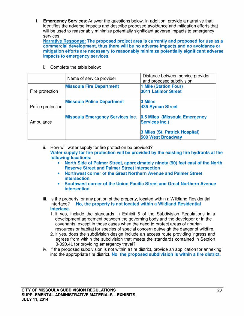
i. Complete the table below:
Name of service provider Distance between service provider and proposed subdivision
Fire protection Missoula Fire Department
1 Mile (Station Four) 3011 Latimor Street
Police protection Missoula Police Department 3 Miles
435 Ryman Street
Ambulance Missoula Emergency Services Inc. 0.5 Miles (Missoula Emergency
Services Inc.) 3 Miles (St. Patrick Hospital) 500 West Broadway
ii. How will water supply for fire protection be provided? Water supply for fire protection will be provided by the existing fire hydrants at the following locations:
• North Side of Palmer Street, approximately ninety (90) feet east of the North Reserve Street and Palmer Street intersection
• Northwest corner of the Great Northern Avenue and Palmer Street intersection
• Southwest corner of the Union Pacific Street and Great Northern Avenue intersection
iii. Is the property, or any portion of the property, located within a Wildland Residential
Interface? No, the property is not located within a Wildland Residential Interface. 1. If yes, include the standards in Exhibit 6 of the Subdivision Regulations in a
development agreement between the governing body and the developer or in the covenants, except in those cases when the need to protect areas of riparian resources or habitat for species of special concern outweigh the danger of wildfire.
2. If yes, does the subdivision design include an access route providing ingress and egress from within the subdivision that meets the standards contained in Section 3-020.4L for providing emergency travel?
iv. If the proposed subdivision is not within a fire district, provide an application for annexing into the appropriate fire district. No, the proposed subdivision is within a fire district.
CITY OF MISSOULA SUBDIVISION REGULATIONS SUPPLEMENTAL ADMINISTRATIVE MATERIALS – EXHIBITS JULY 11, 2014
24
g. Housing: Answer the questions below. In addition, provide a narrative that identifies the adverse impacts and describe proposed avoidance and mitigation efforts that will be used to reasonably minimize potentially significant adverse impacts to housing. Narrative Response: The proposed project area is currently used for commercial development, thus there will be no adverse impacts and no avoidance or mitigation efforts are necessary to reasonably minimize potentially significant adverse impacts to housing.
i. Describe the total number of dwellings anticipated by type (such as single dwelling, multiple dwelling, or mobile home). Not applicable, the proposed subdivision is commercial and no dwelling units are proposed.
ii. Estimate the market cost of the dwellings and rents for rental units in this subdivision. Not applicable, the proposed subdivision is commercial and no dwelling units are proposed.
iii. What is the approximate average number of bedrooms per dwelling unit anticipated for the subdivision? Not applicable, the proposed subdivision is commercial and no dwelling units are proposed.
iv. Is the subdivision planned as a second home? Not applicable, the proposed subdivision is commercial and is not planned as a second home.
v. What is the expected date of full development and occupancy for this subdivision? Not applicable, the proposed subdivision is commercial and no dwelling units are proposed.
i. Open space and parkland dedication: Answer the questions below. In addition, provide a narrative that identifies the adverse impacts and describe proposed avoidance and mitigation efforts that will be used to reasonably minimize potentially significant adverse impacts to open space and park land.
Narrative Response: The proposed project area is currently used for commercial development, thus there will be no adverse impacts and no avoidance or mitigation efforts are necessary to reasonably minimize potentially significant adverse impacts to open space and park land.
i. Open spaces: Describe how the subdivision provides adequate open spaces for travel, light, air, and recreation (per MCA 76-3-501(5)). Not applicable, the proposed subdivision is for continued commercial use.
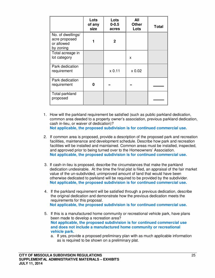
ii. Park land: Complete the table below to calculate the park dedication requirement for the subdivision: Not applicable, the proposed subdivision is for commercial use.
CITY OF MISSOULA SUBDIVISION REGULATIONS SUPPLEMENTAL ADMINISTRATIVE MATERIALS – EXHIBITS JULY 11, 2014
25
Lots of any size
Lots 0-0.5 acres
All Other Lots
Total
No. of dwellings/ acre proposed or allowed by zoning
1
2
Total acreage in lot category
x
Park dedication requirement
x 0.11
x 0.02
Park dedication requirement
0
=
=
Total parkland proposed
1. How will the parkland requirement be satisfied (such as public parkland dedication, common area deeded to a property owner’s association, previous parkland dedication, cash in-lieu, or waiver of dedication)? Not applicable, the proposed subdivision is for continued commercial use.
2. If common area is proposed, provide a description of the proposed park and recreation facilities, maintenance and development schedule. Describe how park and recreation facilities will be installed and maintained. Common areas must be installed, inspected, and approved prior to being turned over to the Homeowners’ Association. Not applicable, the proposed subdivision is for continued commercial use.
3. If cash-in-lieu is proposed, describe the circumstances that make the parkland dedication undesirable. At the time the final plat is filed, an appraisal of the fair market value of the un-subdivided, unimproved amount of land that would have been otherwise dedicated to parkland will be required to be provided by the subdivider. Not applicable, the proposed subdivision is for continued commercial use.
4. If the parkland requirement will be satisfied through a previous dedication, describe the original dedication and demonstrate how the previous dedication meets the requirements for this proposal. Not applicable, the proposed subdivision is for continued commercial use.
5. If this is a manufactured home community or recreational vehicle park, have plans been made to develop a recreation area? Not applicable, the proposed subdivision is for continued commercial use and does not include a manufactured home community or recreational vehicle park. a. If yes, provide a proposed preliminary plan with as much applicable information
as is required to be shown on a preliminary plat.
CITY OF MISSOULA SUBDIVISION REGULATIONS SUPPLEMENTAL ADMINISTRATIVE MATERIALS – EXHIBITS JULY 11, 2014
26
L. PRELIMINARY PLAT REQUIREMENTS: Preliminary plat submittals must conform to the requirements of the Subdivision Regulations Section 5-010. The following list is provided in order to assist applicants in preparing preliminary plats; however, it is not intended to be an all- encompassing or exclusive list.
See the attached Preliminary Plat included in Section 1.0 of this application.
1. Preparation: The plat must be prepared by a professional land surveyor licensed to practice in the State of Montana.
2. Format: The size of the plat must be 24" x 36" with a 1½" margin on the binding side and should be folded to a maximum of 9" x 12". Each sheet shall show the number of that sheet and the total number of sheets included.
3. Identifying Information: The following identifying information must be clearly indicated on the plat. □ Subdivision or development name □ Legal description □ North arrow □ Scale used on the plat
□ Names of owner(s) of record and sub- divider(s)
□ Date plat was drawn
4. Survey Information: The following survey information shall be shown on the preliminary plat or shall be contained in a written statement or supplementary drawing accompanying the preliminary plat: □ Exterior boundaries of the platted tracts; □ Approximate location of all section or legal subdivision corners pertinent to the subdivision boundaries. Township, range, principal meridian, section and quarter section(s) if portion of a section, or other general legal description; □ Approximate dimensions and area of each lot. Lots and blocks shall be designated by
number and area. □ All streets, alleys, avenues, roads, and highways and the proposed width of each,
with existing and proposed street names; □ The area, locations, boundaries, and dimensions of all parks, common areas, and other areas
dedicated for public use; □ The total gross area of the subdivision and the total net area, exclusive of public
areas and rights-of-way; □ Ground elevations of the tract: elevations and benchmarks. Contour intervals shall
be vertical intervals of two (2) feet where the average slope of the subdivision is less than ten (10) percent and at intervals of five (5) feet where the average slope of the subdivision is ten (10) percent or greater;
□ Approximate location and identification of all existing and proposed private and public easements and rights-of-way, including descriptions of their widths and purposes;
□ Existing and/or proposed irrigation ditch easements; □ Easements for any feature or improvement that encroaches onto adjoining private property;
□ Proposed locations of intersections, other access points and access control lines for any subdivision requiring access to major highways or thoroughfares, including those under state jurisdiction;
□ Identified hazard areas shall be prominently shown on the subdivision plat and in other records of conveyance;
□ Any proposed "No-Build Zones" and "No-Build/No-Alteration Zones"; □ The area of the subdivision within the FEMA-designated floodway and/or flood-fringe, if applicable
