3.1.1 the role of the ebrc within the cbd
TRANSCRIPT

3.1.1 The Role of the EBRC within the CBD
The intention is for the EBRC to act as the catalyst in
transforming the Apies river into a continuous greenbelt
through the city that provides an ecological, cultural and
social link from the north to the south of the city. The EBRC
needs to 'activate' or ‘animate’ the river in its context. The
greenbelt should form informal cultivation gardens for the
EBRC, reintroducing indigenous medicinal plants into the
environment. This greenbelt will form a type of urban
agriculture whereby the roots, bark, leaves etc can be
harvested sustainably. The biophysical environment will be
pulled from the ridges (See fig.3.4-7) into the city at the
same time directing people along it towards the ridges. The
sequence on page 34 indicates the envisioned process of
‘animation’ that will result from the EBRC.
029 URBAN DESIGN
UUnniivveerrssiittyy ooff PPrreettoorriiaa eettdd -- BBuuttcchheerr,, AA ((22000033))

3.3 Frame 3 - ‘Nature Corridors’ spread perpendicular from
the greenbelt, moving away from the river linking the smaller green
patches and cultural installations. The vegetation from Salvokop
continues to spread northwards.
3.4 Frame 4 - The lines of vegetation meet, linking the ridges.
The emphasis of migration is now on the ‘corridors’, which begin to
form an east west link, from which smaller ‘corridors’ spread.
030URBAN DESIGN
3.1 Frame 1 - This represents the current condition in Pretoria
City with the ridges in the north and south acting as the ‘nature
rooms’ for the city. The Apies River connects these ridges, with
scattered green patches along it. Throughout the city similar green
spaces occur, but with no coherent link between them.
3.2 Frame 2 - With the EBRC established, its function will pull
indigenous vegetation, medicinal plants specifically from the
Witwatersberg Ridge. At the same time, because of its abundance of
existing medicinal plants, vegetation from Salvokop will begin to
spread into the city towards the EBRC, which begins to form the
greenbelt.
UUnniivveerrssiittyy ooff PPrreettoorriiaa eettdd -- BBuuttcchheerr,, AA ((22000033))

031
3.2 Existing Frameworks
3.2.1 ISDF
The Integrated Spatial Development Framework (ISDF) is the
urban design framework currently being utilised for the
Pretoria inner city focussing on its growth and development.
The aim of the ISDF is planning and integration of the city’s
main components; land use, transportation, natural
environment and open space.
Interlinking of open spaces that can be used for recreation
and entertainment is of high importance along with a fully
URBAN DESIGN
3.5 Precinct boundaries
Schoolplaatz
The Zoo
Marabastad
CBD north
CBD central
Church Square
Berea
Salvokop
Hospital Hill
Arcadia
River Park
Sunnyside
Sunnyside west
Sunnyside east
Union Buildings
SITE
UUnniivveerrssiittyy ooff PPrreettoorriiaa eettdd -- BBuuttcchheerr,, AA ((22000033))

032
integrated public transport system. There is also recognition
of the importance of creating a sense of place and
belonging in Pretoria, this is to be assisted by conservation
approach to worthy buildings and structures.
The ISDF divides the inner city into sixteen precincts, these are
to be labelled and developed according to their unique
character. The site for the EBRC falls in the Hospital Hill
precinct and is also influenced by development proposals
for Struben Street, Boom Street, CBD North, the Zoo and
Arcadia.
Proposals for the CBD North and Zoo precincts place an
emphasis on Dr Savage Street with requests for a strong
gateway feature for the CBD and new entrance to the Zoo
linked to the Apies River open space system and public
transport systems.
The Struben Street Boulevard stretches from Marabastad in
the west to the Apies River in the east and forms a strong link
between the Union Buildings, the Zoo and Marabastad. Its
development is separated into three areas; through
Marabastad, from Potgieter Street to Paul Kruger Street and
from Paul Kruger Street to the Apies River (ISDF, 1999, p48).
In the first section where Struben Street crosses D.F.Malan
Drive, a gateway element is to be established to emphasize
the sight line to the Union Buildings tying them to the rest of
the city. The residential street edge through Marabastad is to
be developed in such a way that its historical character is
maintained (ibid).
In the second section there is an emphasis on the Union
Buildings as a focal point by establishing appropriate
building lines and heights to define street spaces. There is
also encouragement for diversity of land use (residential,
retail and office)(ibid).
In the third section the termination of Struben Street is to be
emphasised with a new urban square as a focal point on the
Apies River. In the Arcadia proposal, this square is to be
connected to an inter-precinct ‘art-walk’ that links the Union
Buildings to the Pretoria Art Museum (ibid).
Boom Street runs parallel to Struben Street and shares many
of its characteristics. Boom Street links the Steenhoven Spruit
to the Apies River with proposals for urban open spaces at
both these points of connection. Environmental upgrading
required in the Marabastad section is to enhance high
activity/ trade image that exists (ISDF, 1999, p51).
The ISDF recognises the Hospital Hill precinct as a largely
institutional area with mainly educational and medical
facilities. Most of the emphasis is placed on establishing an
identity for the precinct along the roads and intersections,
unfortunately with little emphasis on making the precinct
more permeable and enhancing important pedestrian links.
There is also little emphasis on the Apies River that runs
through the middle of the entire area.
Many of these principles are repeated in the Apies River
Urban Design Framework.
3.2.2 ARUDF
The aims of the Apies River Urban Design Framework (ARUDF)
are:
-To exploit the river as a natural and cultural asset to Pretoria
by making it an accessible, integrated open space system.
-To turn the river into a place of prosperity and human
URBAN DESIGN
UUnniivveerrssiittyy ooff PPrreettoorriiaa eettdd -- BBuuttcchheerr,, AA ((22000033))

033
interaction by creating tourist opportunities and pedestrian
activities along it.
-To strengthen the interaction between the river and its
surrounding environment by creating an appropriate
interface with adjacent developments and by making it user
friendly for locals and visitors (ARUDF, 1999, p84).
By integrating the principles of the ISDF and the ARUDF, the
following small scale design framework was created.
URBAN DESIGN
UUnniivveerrssiittyy ooff PPrreettoorriiaa eettdd -- BBuuttcchheerr,, AA ((22000033))

034
3.3 Proposed Framework
3.3.1 Environmental
-Indigenous vegetation is to be increased on the ridges and
pulled through (along with vegetation from the Zoological
gardens) the greenbelt, strengthening it and rehabilitating
the biophysical landscape along the river (See fig.3.9).
-This indigenous vegetation should include medicinal plants
creating the possibility of an urban agriculture within the
greenbelt.
-Small nature rooms (Dewar and Uytenbogaardt, 1991, p81)
should be encouraged to spread into residual building
space creating private social spaces and encouraging
pedestrian movement.
-Nature corridors are to be pushed along paths of
movement creating strong links between cultural, social,
URBAN DESIGN
3.6 Nature corridors linking cultural facilities
Indigenous vegetation from ridges
‘Nature rooms’
‘Nature corridors’
Cultural development along‘Nature corridors’Pr
eto
ria Z
oo
Ho
ve’s
Drif
t
Lio
ns
Brid
ge
Unio
n B
uild
ing
s
UUnniivveerrssiittyy ooff PPrreettoorriiaa eettdd -- BBuuttcchheerr,, AA ((22000033))

035
entertainment and open spaces, while encouraging the
further development of these facilities (See fig.3.9).
-Built form should be integrated into the landscape creating
semi-enclosed spaces for social interaction, integration of
indoor and outdoor space and creating a responsive space
on the river.
-When possible, trees should be planted rather than shrubs
as this allows for visibility through the greenbelt and prevents
hiding spaces for undesirables.
-Biophysical landscaping should take place as this requires a
lower maintenance, allows the greenbelt to spread on its
own and increases the bio-diversity.
-Create a damming system (with early flood warning
devices) where the channel changes from concrete to
natural to slow the water velocity, preventing erosion at this
point (See fig.3.10).
-Use this damming system as an alternate small-scale
energy source.
URBAN DESIGN
3.7 Apies River link to Zoological gardensPermeable buildings follow river form
Gateway building
Panoramas from higher areas
Transition of biophysical
environments
UUnniivveerrssiittyy ooff PPrreettoorriiaa eettdd -- BBuuttcchheerr,, AA ((22000033))

036
-Built form should emphasise the transition between the
urban and rural river, creating awareness of the biophysical
environment (See fig.3.10).
-New buildings along the river should be permeable
providing sight lines to the river, especially for the higher
areas to the east. Panoramas of the city skyline and ridges
should not be obscured.
3.3.2 Movement
-There needs to be a strong identity node at the termination
of Nelson Mandela Drive that offers direction towards other
cultural facilities in the city (See fig.3.11).
-A gateway building for the CBD is to be placed at Hove’s
Drift. It should be a mix-use building that facilitates the
existing taxi-terminus, and should pull trade activity from
Marabastad and push pedestrian activity along Nelson
Mandela Drive northwards.
-A strong pedestrian route is needed to link the taxi-terminus
to Belle Ombre train station. This route is to continue
URBAN DESIGN
3.8 Movement around the site
Be
lle O
mb
re s
tatio
n
High profile vehicular link to CBD
Pedestrian link along the river
Bicycle route
Termination / identity point
Public transport stops linked to pedestrian walk
UUnniivveerrssiittyy ooff PPrreettoorriiaa eettdd -- BBuuttcchheerr,, AA ((22000033))

037
southwards to Nelson Mandela Drive.
-A bicycle path should follow this pedestrian route to
encourage alternative transport methods.
-Car parking should be placed near the river with public
transport stops at regular intervals along the river to promote
the river as an activity spine.
-Establish an east/west cultural walk from the Zoo / Aquarium
(where it ties to ‘Museum Park’) to the Union Buildings with
retail / entertainment facilities to be located along this.
Extend this walk to the Pretoria Art Gallery (See fig.3.12).
-A north/south cultural walk exists (See fig.3.17). Where these
walks intersect at the Apies River, a strong cultural node is to
be formed.
-Maintain the existing retail functions along Struben Street to
form a soft edge to define the south end of the precinct.
URBAN DESIGN
3.9 Activity links
Link
to M
use
um
Pa
rk
Pre
toria
Zo
o
Ho
ve’s
Drif
t
Lio
ns
Brid
ge
Unio
n B
uild
ing
s
Existing retail functions
East west cultural link
North south cultural link
UUnniivveerrssiittyy ooff PPrreettoorriiaa eettdd -- BBuuttcchheerr,, AA ((22000033))

038
3.3.3 Imageability
-A linear focal point or active edge is needed on Dr Savage
Street to slow traffic, integrate the two adjacent land parcels
and create awareness of the facilities within the precinct
(See fig.3.13).
-Perimeter walls need to be both physically and visually
permeable, contributing to the imageability of the precinct.
-Existing walls along the river should be opened-up providing
views on and across the river (See fig.3.13).
-All the bridge crossings along the river need to be
accentuated creating awareness of the river and
emphasising its cultural heritage.
-Public amenities, bus stops, street furniture etc. are to be
provided along the river. These must reflect the image of the
river to form a coherent linear structure.
-The existing residential pocket should be reserved for
student accommodation, linking nodes within the precinct.
Spaces amongst the existing institutions should be tied to the
URBAN DESIGN
3.10 Activity hierarchy
Linear activity
River to open up and interact with surrounding buildings
Emphasis to be placed on bridges
UUnniivveerrssiittyy ooff PPrreettoorriiaa eettdd -- BBuuttcchheerr,, AA ((22000033))
039
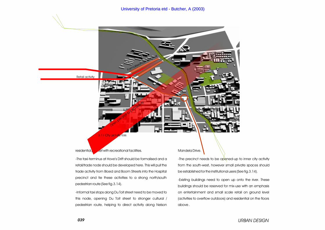
residential pocket with recreational facilities.
-The taxi-terminus at Hove’s Drift should be formalised and a
retail/trade node should be developed here. This will pull the
trade activity from Bloed and Boom Streets into the Hospital
precinct and tie these activities to a strong north/south
pedestrian route (See fig.3.14).
-Informal taxi stops along Du Toit street need to be moved to
this node, opening Du Toit street to stronger cultural /
pedestrian route, helping to direct activity along Nelson
Mandela Drive.
-The precinct needs to be opened-up to inner city activity
from the south-west, however small private spaces should
be established for the institutional users (See fig.3.14).
-Existing buildings need to open up onto the river. These
buildings should be reserved for mix-use with an emphasis
on entertainment and small scale retail on ground level
(activities to overflow outdoors) and residential on the floors
above .
URBAN DESIGN
3.11 City activity loss
Retail activity
Open pre
cinct to C
BD a
ctivity
Formalise
d taxi t
erminus
UUnniivveerrssiittyy ooff PPrreettoorriiaa eettdd -- BBuuttcchheerr,, AA ((22000033))

040
-New buildings are to celebrate the river and interact with the
biophysical environment. They should follow the form of the
river so as not to create any possible lost spaces (See
fig.3.15).
-Flood plains should be reserved for biophysical vegetation
and pedestrian movement.
-Bridging should be encouraged within the large land
parcels. This will form links across the river and create an
awareness of the river.
-Prefabricated structures along the river should be replaced
with more responsive, appropriate building types that will
enhance the qualities of the green belt.
-Existing historical buildings and those with architectural merit
should be emphasised and integrated into the green belt
system.
URBAN DESIGN
3.12 Built form within the biophysical environment
Buildings to interact with the biophysical environment
Bridging to link land parcels
UUnniivveerrssiittyy ooff PPrreettoorriiaa eettdd -- BBuuttcchheerr,, AA ((22000033))

041
3.3.4 Cultural
-All the cultural / historical assets (See fig.3.17) along the river
should be made recognisable. Relevant information
(placards, booths, tours, etc) is to made available within
these areas. This will create a strong cultural / educational
walk along the entire river.
-The Caledonian precinct is recognised as an arts and
culture node, associated facilities must be encouraged to
become established here. A link to ‘Museum Park’ should be
established (See fig.3.17).
-The open grounds on the Pretoria Technikon Arts campus
should become a public sculpture garden integrated into
the greenbelt, from which a strong link must be made to the
Caledonian precinct (See fig.3.16).
-Enforce the gateway at Hove’s Drift by locating a new
entrance to the Zoo on Soutpansberg Street. The
recreational activities within the Zoo are to be extended to
the new entrance, tying them into the Apies River green belt
URBAN DESIGN
3.13 Implied cultural links
Zoo linked to Apies River with location of new entrance
Pretoria Zoo
Maintain sight line to Union Buildings
Arts walk linking Pretoria Technikon Arts campus and Caledonian precinct
UUnniivveerrssiittyy ooff PPrreettoorriiaa eettdd -- BBuuttcchheerr,, AA ((22000033))

URBAN DESIGN
Du Preezhoek Cemetery (circa 1840)
042NZASM Bridge (circa 1893)
Berea Park Sport Club (circa 1928)
Victoria Bridge (circa 1907)
Moerdyk Street Houses (circa 1930)
Breytenbach Theatre
Skinner Street Footbridge
Tram Bridge Site
Theosophical Society
Palm trees (circa 1910)
Lion Bridge (1894)
Caledonian Sports Field (circa 1905)
National Zoological Gardens including old cages, Sammy Marks fountain, Gunning memorial bench (circa 1899)
Hove’s Drift (circa 1870)
Museum Park
and pulling them into the city and encouraging
pedestrian activity northwards (See fig.3.16).
-The Pretoria Technikon Art Campus and the
medical campus should be linked over river
(through the sculpture garden) to form a student
activity node. A pedestrian link could form
between this node and the Caledonian arts
node.
-Buildings along the Struben Street Goverment
Boulivard must not obstruct any sight lines to the
Union Buildings. New buildings on the Technikon
Art Campus should frame views of the Union
Buildings (See fig.3.16).
3.14 Cultural assets along the Apies River
Pretoria Technikon Arts campus
Caledonian precinct
UUnniivveerrssiittyy ooff PPrreettoorriiaa eettdd -- BBuuttcchheerr,, AA ((22000033))