3.2.1 army assessment results army training range
TRANSCRIPT

Chapter 3: Adequacy of Existing Range Resources to Meet Training Requirements
2012 Sustainable Ranges Report | 29May 2012
3.2.1 Army Assessment Results9
Army Training Range Capability Assessment Analysis ResultsThe Army Range Capability Assessment data from 15 Army range complexes are summarized and presented in Table 3-1.
The Army Range Capability Chart and Scores are presented in Figure 3-2 and assessments by Range, Attributes, and Mission Areas are shown in Figures 3-4, 3-6, and 3-8.
The Army’s 15 individual range capability assessments along with comments for red and yellow ratings are included at the end of this section (Figure 3-10).
Army Training Range Encroachment Assessment Analysis ResultsArmy Range Encroachment Assessment data from the 15 Army ranges complexes are summarized in Table 3-2.
The Army Range Encroachment Chart and Scores are presented in Figure 3-3 and assessments by Range, Factors, and Mission Areas are shown in Figures 3-5, 3-7, and 3-9.
The Army’s 15 individual range encroachment assessments along with comments for red and yellow ratings are included at the end of this section (Figure 3-10).
The Army Range Capability and Encroachment assessment comparisons are presented in Table 3-3.
9 Of the 556 ranges identified in the Army’s range inventory in Appendix C, there are a total of 102 that are resourced and fall under the Army’s Sustainable Range Program. These 102 ranges comprise three tiers that were established using mission value, to include: unit stationing, institutional schools/other mission support, land asset size, and level of training (individual, crew, collective). Training sites that are not part of the 102 supported sites are typically small individual training ranges that are managed through local Army National Guard (ARNG)/state agreements and policies; the Army only maintains inventory level data for these sites. Although the Army continually evaluates all ranges, only the 21 ranges that represent Tier I sites are included in the assessments due to the impracticality of compil-ing the information for every range. There are seven ranges inventoried separately in Hawaii that are grouped together for the assessment because they represent a single training complex for management purposes. The Tier I installations represent 88 percent of the training load on Army active duty ranges.

Chapter 3: Adequacy of Existing Range Resources to Meet Training Requirements
| 2012 Sustainable Ranges Report30 May 2012
Table 3-1 Army Capability Assessment Data Summary
Range NMC PMC FMCCapability
ScoresFort Benning 1 3 37 9.39
Fort Bliss 0 5 37 9.40
Fort Bragg 0 8 35 9.07
Fort Campbell 0 8 34 9.05
Fort Carson 0 4 38 9.52
Fort Drum 0 7 36 9.19
USAG Hawaii 0 7 34 9.15
Fort Hood 0 7 38 9.22
Fort Irwin 0 14 40 8.70
Fort Lewis 0 14 28 8.33
Fort Polk 0 6 39 9.33
Fort Riley 0 7 35 9.17
Fort Stewart 0 5 37 9.40
Fort Wainwright 0 7 35 9.17
Yakima TC 0 4 38 9.52
HQ Army 1 106 541 9.17
Table 3-2 Army Encroachment Assessment Data Summary
Range Severe Moderate MinimalEncroachment
ScoresFort Benning 1 8 33 8.81
Fort Bliss 0 3 38 9.63
Fort Bragg 0 5 36 9.39
Fort Campbell 0 1 40 9.88
Fort Carson 1 1 50 9.71
Fort Drum 0 0 39 10.00
USAG Hawaii 0 11 34 8.78
Fort Hood 0 4 38 9.52
Fort Irwin 0 15 39 8.61
Fort Lewis 0 12 30 8.57
Fort Polk 0 4 37 9.51
Fort Riley 0 3 30 9.55
Fort Stewart 0 21 25 7.72
Fort Wainwright 0 6 40 9.35
Yakima TC 0 7 34 9.15
HQ Army 2 101 543 9.19
Chapter 3: Adequacy of Existing Range Resources to Meet Training Requirements
2012 Sustainable Ranges Report | 31May 2012
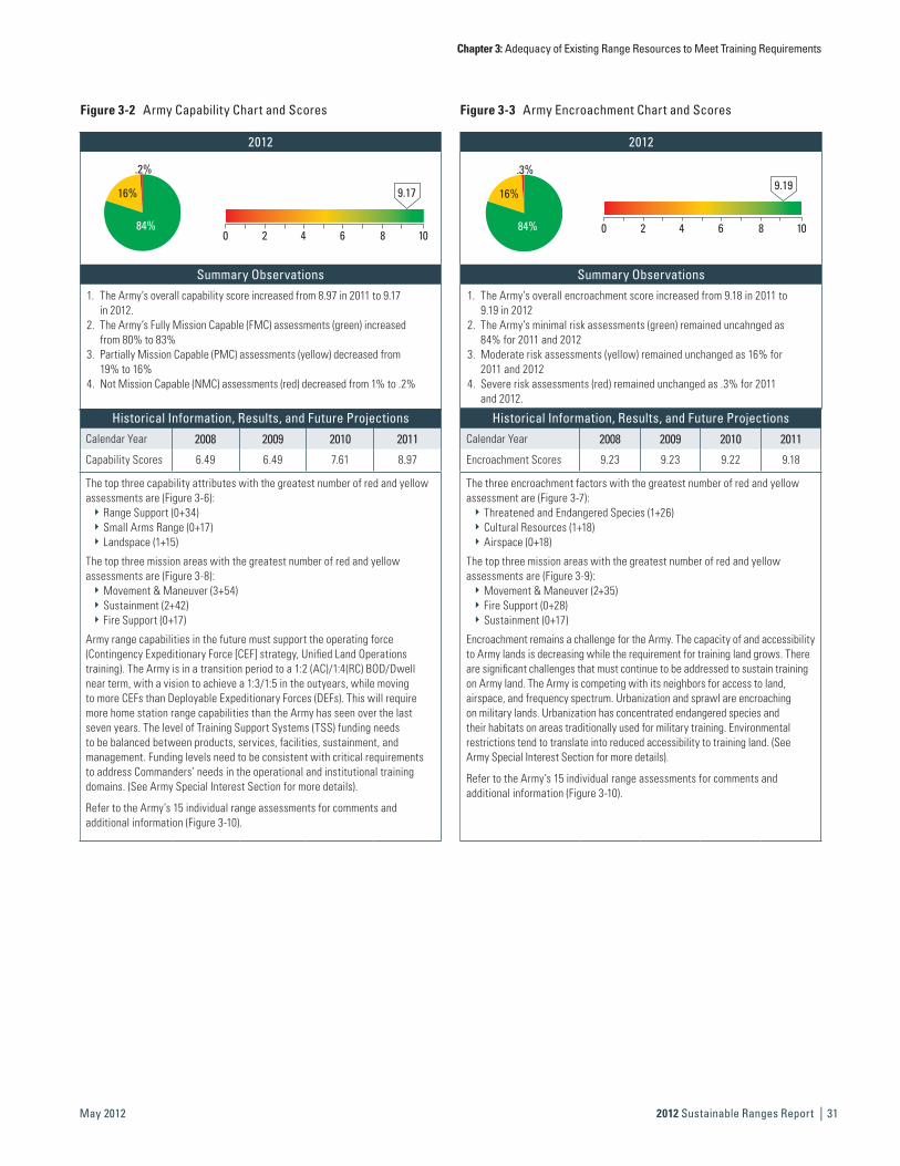
2012
16%
84%
.2%
Summary Observations1. The Army’s overall capability score increased from 8.97 in 2011 to 9.17
in 2012.2. The Army’s Fully Mission Capable (FMC) assessments (green) increased
from 80% to 83%3. Partially Mission Capable (PMC) assessments (yellow) decreased from
19% to 16%4. Not Mission Capable (NMC) assessments (red) decreased from 1% to .2%
2012
16%
84%
.3%
Summary Observations1. The Army’s overall encroachment score increased from 9.18 in 2011 to
9.19 in 20122. The Army’s minimal risk assessments (green) remained uncahnged as
84% for 2011 and 2012 3. Moderate risk assessments (yellow) remained unchanged as 16% for
2011 and 20124. Severe risk assessments (red) remained unchanged as .3% for 2011
and 2012.
9.17
0 2 4 6 8 10
9.19
0 2 4 6 8 10
Historical Information, Results, and Future ProjectionsCalendar Year 2008 2009 2010 2011
Capability Scores 6.49 6.49 7.61 8.97
The top three capability attributes with the greatest number of red and yellow assessments are (Figure 3-6):
`` Range Support (0+34)`` Small Arms Range (0+17)`` Landspace (1+15)
The top three mission areas with the greatest number of red and yellow assessments are (Figure 3-8):
`` Movement & Maneuver (3+54)`` Sustainment (2+42)`` Fire Support (0+17)
Army range capabilities in the future must support the operating force (Contingency Expeditionary Force [CEF] strategy, Unified Land Operations training). The Army is in a transition period to a 1:2 (AC)/1:4(RC) BOD/Dwell near term, with a vision to achieve a 1:3/1:5 in the outyears, while moving to more CEFs than Deployable Expeditionary Forces (DEFs). This will require more home station range capabilities than the Army has seen over the last seven years. The level of Training Support Systems (TSS) funding needs to be balanced between products, services, facilities, sustainment, and management. Funding levels need to be consistent with critical requirements to address Commanders’ needs in the operational and institutional training domains. (See Army Special Interest Section for more details).
Refer to the Army’s 15 individual range assessments for comments and additional information (Figure 3-10).
Historical Information, Results, and Future ProjectionsCalendar Year 2008 2009 2010 2011
Encroachment Scores 9.23 9.23 9.22 9.18
The three encroachment factors with the greatest number of red and yellow assessment are (Figure 3-7):
`` Threatened and Endangered Species (1+26)`` Cultural Resources (1+18)`` Airspace (0+18)
The top three mission areas with the greatest number of red and yellow assessments are (Figure 3-9):
`` Movement & Maneuver (2+35)`` Fire Support (0+28)`` Sustainment (0+17)
Encroachment remains a challenge for the Army. The capacity of and accessibility to Army lands is decreasing while the requirement for training land grows. There are significant challenges that must continue to be addressed to sustain training on Army land. The Army is competing with its neighbors for access to land, airspace, and frequency spectrum. Urbanization and sprawl are encroaching on military lands. Urbanization has concentrated endangered species and their habitats on areas traditionally used for military training. Environmental restrictions tend to translate into reduced accessibility to training land. (See Army Special Interest Section for more details).
Refer to the Army’s 15 individual range assessments for comments and additional information (Figure 3-10).
Figure 3-2 Army Capability Chart and Scores Figure 3-3 Army Encroachment Chart and Scores

Chapter 3: Adequacy of Existing Range Resources to Meet Training Requirements
| 2012 Sustainable Ranges Report32 May 2012
Figure 3-9 Army Encroachment Assessment by Mission Areas
0 30 60 90 120 150Movement & Maneuver
Fire SupportIntelligence
SustainmentCommand & Control
Protection 10717
5
2 359728
8265
108
90
100
Number of Assessments
Severe Moderate Minimal
Figure 3-7 Army Encroachment Assessment by Factors
0 20 40 60 80 100Range Transients
Wetlands
Water Quality/Supply
Cultural Resources
Adjacent Land Use
Noise Restrictions
Air Quality
Airspace
Maritime Sustainability
Spectrum
Munitions Restrictions
T&E Species
Number of Assessments
Severe Moderate Minimal
74
66
71
62
50
47
74
18
4
0
18
9 14
13
61
8
4
6
1
261
18
1
Figure 3-8 Army Capability Assessment by Mission Areas
0 30 60 90 120 150Movement & Maneuver
Fire SupportIntelligence
SustainmentCommand & Control
Protection
2
3 54
10517
3
6
1 97
52
89
78
42
99
NMC PMC FMC
Number of Assessments
Figure 3-6 Army Capability Assessment by Attributes
0
0
0
0
0 20 40 60 80 100Suite of RangesMOUT Facilities
Collective RangesSmall Arms Ranges
Range SupportInfrastructure
Scoring & Feedback SystemsThreatsTargets
UnderseaspaceSeaspaceAirspace
Landspace
89
51
79
72
573
48
73
12
17
15
10
4
1
32
34
5
15
12
1
NMC PMC FMC
Number of Assessments
0 10 20 30 40 50 60Yakima
Fort Wainwright
Fort Stewart
Fort Riley
Fort Polk
Fort Lewis
Fort Irwin
Fort Hood
USAG Hawaii
Fort Drum
Fort Carson
Fort Campbell
Fort Bragg
Fort Bliss
Fort Benning
347
384
357
375
357
396
2814
4014
387
367
348
384
358
375
3731
NMC PMC FMC
Number of Assessments
Figure 3-4 Army Capability Assessments by Range Figure 3-5 Army Encroachment Assessments by Range
0 10 20 30 40 50 60
Yakima
Fort Wainwright
Fort Stewart
Fort Riley
Fort Polk
Fort Lewis
Fort Irwin
Fort Hood
USAG Hawaii
Fort Drum
Fort Carson
Fort Campbell
Fort Bragg
Fort Bliss
Fort Benning
39
3411
347
406
2521
303
374
3012
3915
384
365
331 8
383
Number of Assessments
Severe Moderate Minimal
401
5011
Chapter 3: Adequacy of Existing Range Resources to Meet Training Requirements
2012 Sustainable Ranges Report | 33May 2012
Army Special Interest Section
Critical Issues: Range Capabilities
Force RealignmentIn the past, Brigade Combat Teams (BCTs) from different installations deployed together, spreading the impact of ARFORGEN across a number of installations. As part of the nine month BOG policy described in Chapter 2, each BCT will be aligned to a “parent” division. This will result in most units on a given installation being on the same ARFORGEN cycle, placing ranges under a period of high demand, followed by periods of no demand when units are deployed. Additionally, Army end strength, force structure, and stationing changes will impact range demand and use dynamics. There will be fewer units; however, with OEF demand decreasing, there will be more units at home-station competing for finite range assets.
ManpowerFY2011 manpower reductions across the Army will adversely affect Army range operations and training land management functions across all installations. In range operations, 361 civilian authorizations were cut, representing a 17 percent reduction to the range operations civilian workforce; in training land management, 38 civilian authorizations were cut, representing a 56 percent reduction to the training land management civilian workforce. Over the past several years, significant efforts were made to bring civilian staff levels at installations into balance with the mission and training loads (Standard Garrison Organization) by FY2012. Efforts to further reduce costs and find efficiencies across DoD have resulted in reducing civilian staff to FY2010 levels, negating the good effects of the balanced SGO and creating a significant challenge in the Army’s ability to provide balanced support for range operations and training land management at key installations. This issue is further complicated by restrictions on outsourcing. The Army will have to rely on other means, such as soldier Skill Set Utilization (S3U), to support key functions at some installations; however, S3U is only an option when there is a direct correlation between Military Occupation Specialty (MOS) and garrison skills. At this time, no training support system functions have qualified for S3U.
U.S. Special Operations Command TrainingUSSOCOM owns no ranges or training areas; therefore, it is totally dependent on the Military Services for access to limited resources in high demand. The Army recognizes the importance of SPECOPS Forces access to Army ranges, and to date, Army installations have been able to accommodate the training requirements for USSOCOM units. USSOCOM units may have to compete for access to Army range assets as training throughput on all installations increases, due to
increased unit dwell time and home-station training requirements.
The Army’s primary focus has been to support U.S. Army Special Operations Command (USASOC) units. The Army range program has funded five USASOC-designed Military Construction Shoot Houses, a range complex in Okinawa, indoor ranges for each Special Forces Group, and incorporated USASOC capabilities in multi-use ranges when possible over the past five years. Four additional USASOC ranges are programmed. These include ranges at Eglin Air Force Base to exclusively support the 7th Special Forces Group, and plans for regional SPECOPS Forces training capabilities at Fort Bliss, Texas, Yakima Training Center, Washington, and Fort AP Hill, Virginia.
The Army will consider all USSOCOM requests to build dedicated ranges on a case-by-case basis. Army G-3/5/7 will continue to work with USASOC and USSOCOM to ensure adequate range access to the maximum extent possible.
Unmanned Aerial Systems Currently, there are over 1,200 Army UAS platforms deployed in theater, which have flown in excess of one million hours in support of combat operations. The Army will train more than 2,100 UAS operators, maintainers, and leaders in FY2012 to keep pace with the prolific UAS growth. This is an 800 percent increase compared to the FY2003 training quota. Designating controlled airspace, and developing support facilities, ranges and training areas to support UAS training requirements in the near- and long-term remain major challenges facing the Army. The emerging UAS support requirements will impact home-station range and infrastructure requirements, increase the need for frequency deconfliction, and necessitate integration of UAS training into LVC training domains. The Army has published the U.S. Army UAS Roadmap (2010-2035) as well as the Unmanned Aircraft Systems Leader Development, Education, and Training Strategy. The purpose of these documents is to provide a broad vision for how the Army will develop, organize, employ, and train UAS systems and tactics across the full spectrum of operations.
Critical Issues: Encroachment
Competition for Range SpaceEncroachment remains a challenge for the Army. Army’s land capacity and accessibility are decreasing at a time when training land requirements are growing. This is a significant challenge that must continually be addressed to sustain training capabilities, particularly as units redeploy from theater and home-station training requirements increase. The Army is competing with its neighbors for access to land, airspace, and frequency spectrum. Urbanization and sprawl have reduced the amount of available habitat for many species.
Chapter 3: Adequacy of Existing Range Resources to Meet Training Requirements
| 2012 Sustainable Ranges Report34 May 2012
Accordingly, much of the remaining habitat for listed and at-risk species now remains on installation lands. Installation lands are thus becoming “islands of biodiversity.” Environmental restrictions tend to translate into reduced accessibility to training land.
Alternative Energy ProjectsThe nation’s increasing emphasis on energy security and renewable energy sources has increased the number of energy infrastructure projects that have the potential to impact Army training and testing. These energy initiatives include wind turbines, new energy corridors for gas/oil pipelines and high capacity transmission lines, solar arrays, and geothermal projects. The projects are being driven internally by the Army as sponsored projects on its installations, and externally by other federal agencies, such as BLM and private developers. To date, relatively few alternative energy projects have had a negative effect on Army range capabilities; however, a small number of projects have had the potential for significant impact. Continued support and diligence is necessary to ensure that renewable energy projects receive a thorough review for their potential to have serious negative impacts on Army missions and training capability.

Chapter 3: Adequacy of Existing Range Resources to Meet Training Requirements
2012 Sustainable Ranges Report | 35May 2012
This Page is Intentionally Left Blank.

Chapter 3: Adequacy of Existing Range Resources to Meet Training Requirements
| 2012 Sustainable Ranges Report36 May 2012
Figure 3-10 Army Capability and Encroachment Assessment Detail
Fort Benning Assessment Details
Range Mission Description
Fort Benning and the Maneuver Center of Excellence (MCoE) provide trained and adaptive soldiers and leaders for an Army at War, while developing future requirements for the individual soldier and the Maneuver Force, and providing a world class quality of life for our soldiers and Army families. The MCoE Command priorities are to: (1) Fully Support an Army at War; (2) Prepare for the Future; (3) Enhance Quality of Life for soldiers and Army Families; (4) Operate in a Command Climate of Teamwork, Discipline and Standards, and Safety; (5) Fully Transition to the MCoE; and (6) Demonstrate Inspired Leadership. (See full mission description in Table 3-4.)
Capability Data Encroachment Data
Mission Areas
Capability Attributes
Land
spac
e
Airs
pace
Seas
pace
Unde
rsea
spac
e
Targ
ets
Thre
ats
Scor
ing
&
Feed
back
Sys
tem
Infra
stru
ctur
e
Rang
e Su
ppor
t
Smal
l Arm
s Ra
nges
Colle
ctiv
e Ra
nges
MOU
T Fa
cilit
ies
Suite
of R
ange
sMovement & Maneuver
h h h h h h h h h
Fire Support h h h h h h h h
Intelligence h h h
Sustainment h h h h h h
Command & Control
h h h h h h h h
Protection h h h h h h h
Legend FMC PMC NMC
Mission Areas
Encroachment Factors
Thre
aten
ed a
nd
Enda
nger
ed S
peci
es
Mun
ition
s Res
trict
ions
Spec
trum
Mar
itim
e Su
stai
nabi
lity
Airs
pace
Air Q
ualit
y
Noi
se R
estri
ctio
ns
Adja
cent
Lan
d Us
e
Cultu
ral R
esou
rces
Wat
er Q
ualit
y/Su
pply
Wet
land
s
Rang
e Tr
ansi
ents
Movement & Maneuver
h h h h h h h h h
Fire Support h h h h h h h h h
Intelligence h h h h h h h
Sustainment h h h h
Command Control
h h h h h
Protection h h h h h h h h
Legend Minimal Moderate Severe
Capability Chart and Scores Encroachment Chart and Scores
7%
90%
3%
9.39
0 2 4 6 8 10
19%
79%
2%
8.81
0 2 4 6 8 10
Summary Observations Summary Observations
The most severe impact to mission is caused by a shortfall of training land (i.e., Landspace). While several mission areas are more moderately impacted by capability shortfalls, Movement & Maneuver is most severely impacted due to a shortfall of maneuver training land and range support funding shortfalls.
There is a moderate impact to the mission areas due to encroachment factors. The presence of threatened and endangered species on the installation has a significant impact on the Movement & Maneuver mission area. Fort Benning is one of 13 primary core locations selected by the U.S. Fish and Wildlife Service (USFWS) to manage a Red-Cockaded Woodpecker (RCW) recovery population. The Fort Benning RCW population has steadily increased since 2003; however, ongoing construction and other proposed actions associated with the development of the MCoE will result in significant impacts to the long-term recovery goals for the RCW. Fort Benning has completed consultation with USFWS and received a Biological Opinion. Fort Benning is identifying and implementing appropriate mitigation strategies to minimize training restrictions and shortfalls associated with the action.

Chapter 3: Adequacy of Existing Range Resources to Meet Training Requirements
2012 Sustainable Ranges Report | 37May 2012
Fort Benning Assessment Details
Historical Information, Results, and Future Projections Historical Information, Results, and Future ProjectionsCalendar Year 2008 2009 2010 2011 Calendar Year 2008 2009 2010 2011
Capability Scores 6.33 6.33 7.56 8.41 Encroachment Scores 8.25 8.25 8.72 8.72
Capabilities have generally improved at Fort Benning over the past several years, primarily due to increases in range support funding levels. Recent manpower reductions will cause a 20% cut in range operations starting in FY2012. A shortfall of maneuver training land continues to impact mission capability; however, Fort Benning has been granted permission to study the purchase of 82,800 acres of additional training land to help alleviate the maneuver training land shortfall. Recent improvements in capability are the result of range project completions.
Encroachment factors have historically had a moderate impact on the mission at Fort Benning. While the installation has been able to manage and mitigate many encroachment impacts, it is anticipated that increased population growth around the installation is going to continue and will result in more significant encroachment impacts in the future. Increased urban development and population growth impacts water quality, increases wildlife habitat fragmentation, and increases the likelihood of noise/dust complaints. As Fort Benning tries to cope with this encroachment by limiting the type and amount of training in the vicinity of the installation boundary, the land available for training is reduced. Additionally, water quality issues will be a major challenge for the Maneuver Center of Excellence (MCoE) as heavy training begins in the Spring of FY12. The dedicated maneuver training area for the MCoE is higly susceptible to erosion. The combination of severe rain events, combined with existing, impaired state waterways, places manevuer training at risk in the future. The Army has identified erosion control measures that will help reduce the risk of Clean Watr Act violations, but may not be able to totally eliminate them without impacts to training. A reduction of available training area reduces the opportunities to rotate training areas to minimize the effects of training activities and increases the amount of training in areas with fragile habitat. This encroachment is minimizing Fort Benning’s options and ability to balance mission and stewardship requirements. Fort Benning has permission to study the purchase of 82,800 acres of additional training land as a possible option to help mitigate this problem.
Fort Benning Detailed Comments Capability Observations
Attributes Assigned Training Mission Score Comments
LandspaceMovement & Maneuver
h
Fort Benning has a doctrinal training land shortfall that has been documented in accordance with AR 350-19.There is not enough training land to accommodate the Armored Reconnaissance Course (ARC), Ranger Training Brigade (RTB), or the additional training space needed to support a heavy maneuver battalion and the other TRADOC, FORSCOM, and USASOC tenant units. Funding is being programmed in support of a training land purchase at Fort Benning starting in FY2011. Fort Benning is also pursuing other strategies, including partnerships with the Tri-County governments in the Army Compatible Use Buffer/Joint Land Use Study (ACUB/JLUS) programs and has begun funding opportunities for these programs.
Sustainment h Same as above.
Range Support
Movement & Maneuver
h
Recent manpower reductions will cause a 20% cut in range operations starting in FY2012. This will limit installation support for short-term training requests, such as range reconfiguration projects to support emerging tactics, techniques, and procedures; and preventative maintenance. Fort Benning is not able to accommodate unscheduled training events, which limits its training flexibility. Fort Benning will continue to work with units to support both institutional and tactical unit training to the greatest extent possible.
Sustainment h Same as above.
Chapter 3: Adequacy of Existing Range Resources to Meet Training Requirements
| 2012 Sustainable Ranges Report38 May 2012
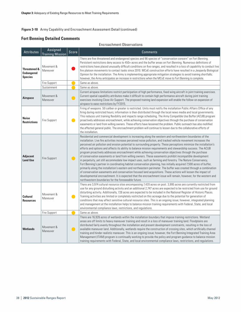
Figure 3-10 Army Capability and Encroachment Assessment Detail (continued)
Encroachment Observations
Attributes Assigned Training Mission Score Comments
Threatened & Endangered Species
Movement & Maneuver
h
There are five threatened and endangered species and 96 species of “conservation concern” on Fort Benning.Persistent restrictions deny access to 450+ acres and the buffer areas on Fort Benning. Numerous definitions of restrictions have placed unusually difficult conditions on five ranges, and resulted in a loss of capability to conduct live fire platoon movements to contact tasks since 2010. MCoE construction efforts have resulted in a Jeopardy Biological Opinion for the installation. The Army is implementing appropriate mitigation strategies to avoid training shortfalls; however, the Army anticipates an increase in restrictions when the MCoE move to Fort Benning is complete.
Fire Support h Same as above.Sustainment h Same as above.
AirspaceMovement & Maneuver
h
Current airspace limitations restrict participation of high performance, fixed wing aircraft in joint training exercises. Current spatial capability attributes make it difficult to contain high performance aircraft during joint training exercises involving Close Air Support. The proposed training land expansion will enable the follow-on expansion of airspace to ease restrictions by FY2015.
Noise Restrictions
Fire Support h
Firing of weapons .50 caliber or greater is restricted. Units must notify the installation Public Affairs Office of any firing during restricted hours; information is then distributed through the local news media and local governments. This reduces unit training flexibility and impacts range scheduling. The Army Compatible Use Buffer (ACUB) program proactively addresses encroachment, while achieving conservation objectives through the purchase of conservation easements or land from willing owners. These efforts have lessened the problem. Public outreach has also mollified the affected general public. The encroachment problem will continue to lessen due to the collaborative efforts of the installation.
Adjacent Land Use
Fire Support h
Residential and commercial development is increasing along the western and northwestern boundaries of the installation. Live fire activities increase perceived noise pollution, and tracked vehicle movement increases the perceived air pollution and erosion potential to surrounding property. These perceptions minimize the installation’s efforts and options and affects its ability to balance mission requirements and stewardship success. The ACUB program proactively addresses encroachment while achieving conservation objectives through the purchase of conservation easements or land from willing owners. These easements prohibit incompatible development in perpetuity, yet still accommodate low impact uses, such as farming and forestry. The Nature Conservancy, Fort Benning’s partner in coordinating habitat conservation planning, has initially acquired 7,500 acres of buffer, primarily along the installation‘s eastern and northeastern perimeter. The buffer was created through a combination of conservation easements and conservation focused land acquisitions. These actions will lessen the impact of developmental encroachment. It is expected that the encroachment issue will remain, however, for the western and northwestern boundaries for the foreseeable future.
Cultural Resources
Movement & Maneuver
h
There are 3,974 cultural resource sites encompassing 7,420 acres on post. 3,995 acres are currently restricted from use for any ground disturbing activity and an additional 2,747 acres are expected to be restricted from use for ground disturbing activity. Additionally, 726 acres are expected to be included in the National Register of Historic Places.Training activities are limited or completely restricted on this acreage due to the potential for generation of conditions that may affect sensitive cultural resource sites. This is an ongoing issue; however, integrated planning and management at the installation helps to balance mission training requirements with Federal, State, and local environmental compliance laws, restrictions, and regulations.
Fire Support h Same as above.
WetlandsMovement & Maneuver
h
There are 16,926 acres of wetlands within the installation boundary that impose training restrictions. Wetland areas are off limits to heavy maneuver training and result in a loss of maneuver training land. Floodplains are distributed fairly evenly throughout the installation and present development constraints, resulting in the loss of available maneuver land. Additionally, wetlands require the construction of crossing sites, which artificially channel training and hinder realistic maneuver. This is an ongoing issue; however, the Fort Benning Integrated Training Area Management (ITAM) program is continually working to provide the policy and program guidance to balance mission training requirements with Federal, State, and local environmental compliance laws, restrictions, and regulations.
Fort Benning Detailed Comments

Chapter 3: Adequacy of Existing Range Resources to Meet Training Requirements
2012 Sustainable Ranges Report | 39May 2012
This Page is Intentionally Left Blank.

Chapter 3: Adequacy of Existing Range Resources to Meet Training Requirements
| 2012 Sustainable Ranges Report40 May 2012
Figure 3-10 Army Capability and Encroachment Assessment Detail (continued)
Fort Bliss Assessment Details
Range Mission Description
Fort Bliss provides major training facilities for the 1st Armored Division, Mobilization Platform, and mobilization and deployment training in support of First Army. Ranges and training areas also support daily air-to-ground sorties from Holloman AFB and other regional Air Force installations. Ranges and training areas further support Foreign Military Sales (FMS) cases for the Japanese, Germans, Dutch, Canadians, and others requesting exercises at the installation.
Capability Data Encroachment Data
Mission Areas
Capability Attributes
Land
spac
e
Airs
pace
Seas
pace
Unde
rsea
spac
e
Targ
ets
Thre
ats
Scor
ing
&
Feed
back
Sys
tem
Infra
stru
ctur
e
Rang
e Su
ppor
t
Smal
l Arm
s Ra
nges
Colle
ctiv
e Ra
nges
MOU
T Fa
cilit
ies
Suite
of R
ange
sMovement & Maneuver
h h h h h h h h h
Fire Support h h h h h h h h
Intelligence h h h h h h
Sustainment h h h h h h
Command & Control
h h h h h h
Protection h h h h h h h
Legend FMC PMC NMC
Mission Areas
Encroachment Factors
Thre
aten
ed a
nd
Enda
nger
ed S
peci
es
Mun
ition
s Res
trict
ions
Spec
trum
Mar
itim
e Su
stai
nabi
lity
Airs
pace
Air Q
ualit
y
Noi
se R
estri
ctio
ns
Adja
cent
Lan
d Us
e
Cultu
ral R
esou
rces
Wat
er Q
ualit
y/Su
pply
Wet
land
s
Rang
e Tr
ansi
ents
Movement & Maneuver
h h h h h h h h
Fire Support h h h h h h h h
Intelligence h h h h h h h h
Sustainment h h h h
Command Control
h h h h h
Protection h h h h h h h h
Legend Minimal Moderate Severe
Capability Chart and Scores Encroachment Chart and Scores
12%
88%
9.40
0 2 4 6 8 10
7%
93%
Summary Observations Summary Observations
The most adverse impact to mission is due to the current lack of Collective Ranges capability. While several mission areas are impacted by capability shortfalls, Movement & Maneuver is most severely impacted due to infrastructure shortfalls at Oro Grande Base Camp, Range Support funding shortfalls, and lack of Collective Ranges capability during construction.
There is minimal impact to the mission areas due to encroachment factors. Spectrum interference has a moderate impact on the Movement & Maneuver, Sustainment, and Command and Control missions areas, due to a reduction in the number of voice channels available for emergency services, range control, and other users.
Historical Information, Results, and Future Projections Historical Information, Results, and Future ProjectionsCalendar Year 2008 2009 2010 2011 Calendar Year 2008 2009 2010 2011
Capability Scores 4.78 4.78 7.33 9.17 Encroachment Scores 10.00 10.00 9.02 9.63
Capabilities have generally improved at Fort Bliss over the past several years. Range Support funding levels increased in FY2011, however, recent manpower reductions will cause a 20% cut in range operations starting in FY2012. Fort Bliss has some current capability and throughput shortfalls due to construction activities that close down Collective Ranges; however, these impacts are being addressed and mitigated. Small Arms Range construction has been completed and Collective Range capability will improve when current construction is complete.
Encroachment Factors have not historically impacted the mission at Fort Bliss. Moderate impacts resulting from Spectrum interference have developed over the past year. These impacts are being managed and mitigated at the installation level, and are expected to improve in the future.
9.63
0 2 4 6 8 10

Chapter 3: Adequacy of Existing Range Resources to Meet Training Requirements
2012 Sustainable Ranges Report | 41May 2012
Fort Bliss Detailed CommentsCapability Observations
Attributes Assigned Training Mission Score Comments
InfrastructureMovement & Maneuver
hOro Grande Base Camp lacks sufficient facilities to accommodate unit training densities (e.g., billets, DFAC). Due to lack of facilities, units incur additional travel days to transport from home station. The installation has recommended purchasing prefabricated buildings.
Range Support
Movement & Maneuver
hRecent manpower reductions will cause a 20% cut in range operations starting in FY2012. This will limit installation support for short-term training requests; range reconfiguration projects to support emerging tactics, techniques, and procedures; and preventative maintenance.
Sustainment h Same as above.
Collective Ranges
Movement & Maneuver
hCollective gunnery ranges will be under construction during FY2010–FY2015. Limited ranges reduce throughput capability to support annual gunnery requirements. Two temporary Multi-Purpose Training Ranges (MPTRs) were built to support current unit requirements until future projected ranges are completed.
Fire Support h
Collective gunnery ranges will be under construction during FY2010–FY2015. Limited ranges reduce throughput capability to support annual gunnery requirements. The installation altered the prescribed construct of 6 firing groups into 23 separate firing boxes to increase maneuverability and flexibility in facilitating fire support missions for fire support events.
Encroachment Observations
Factors Assigned Training Mission Score Comments
Spectrum
Movement & Maneuver
h
The currently allocated spectrum is approximately 70% of the future operationally required spectrum. Additionally, the frequency spectrum must be shared with Mexico. Interference from Mexico on the UHF band sometimes interferes with the trunked Land Mobile Radio System (LMRS) at Fort Bliss, which reduces the number of voice channels available for emergency services, range control, and other users. The installation’s mitigation strategy is to share frequencies and deconflict available spectrum. The DoD Area Frequency Coordinator (AFC) is working to issue single Radio Frequency Authorizations (RFAs) that include frequency assignments for operations at Fort Bliss, WSMR, and/or Holloman AFB. All frequencies will be scheduled and deconflicted in the Integrated Frequency Deconfliction System (IFDS) database. Spectrum managers at each installation will submit requests for new permanent frequency assignments, as required.
Sustainment h Same as above.Command & Control h Same as above.

Chapter 3: Adequacy of Existing Range Resources to Meet Training Requirements
| 2012 Sustainable Ranges Report42 May 2012
Figure 3-10 Army Capability and Encroachment Assessment Detail (continued)
Fort Bragg Assessment Details
Range Mission Description
Fort Bragg provides major training facilities, to include ranges and training areas, non-firing activities, airborne/air operations and training land/airspace use on Camp MacKall in support of DoD organizations; the mission of the USASOC/XVIII ABN Corps and 82nd Airborne Division, and their operational forces; and mobilization and force modernization.
Capability Data Encroachment Data
Mission Areas
Capability Attributes
Land
spac
e
Airs
pace
Seas
pace
Unde
rsea
spac
e
Targ
ets
Thre
ats
Scor
ing
&
Feed
back
Sys
tem
Infra
stru
ctur
e
Rang
e Su
ppor
t
Smal
l Arm
s Ra
nges
Colle
ctiv
e Ra
nges
MOU
T Fa
cilit
ies
Suite
of R
ange
sMovement & Maneuver
h h h h h h h h h
Fire Support h h h h h h h h
Intelligence h h h h h h
Sustainment h h h h h h h
Command & Control
h h h h h h
Protection h h h h h h h
Legend FMC PMC NMC
Mission Areas
Encroachment Factors
Thre
aten
ed a
nd
Enda
nger
ed S
peci
es
Mun
ition
s Res
trict
ions
Spec
trum
Mar
itim
e Su
stai
nabi
lity
Airs
pace
Air Q
ualit
y
Noi
se R
estri
ctio
ns
Adja
cent
Lan
d Us
e
Cultu
ral R
esou
rces
Wat
er Q
ualit
y/Su
pply
Wet
land
s
Rang
e Tr
ansi
ents
Movement & Maneuver
h h h h h h h h
Fire Support h h h h h h h h
Intelligence h h h h h h h
Sustainment h h h h h
Command Control
h h h h h h
Protection h h h h h h h
Legend Minimal Moderate Severe
Capability Chart and Scores Encroachment Chart and Scores
19%
81%
9.07
0 2 4 6 8 10 88%
12% 9.39
0 2 4 6 8 10
Summary Observations Summary Observations
The most adverse impact to mission is caused by a shortfall of training land (i.e., Landspace), Airspace, and Collective Ranges. While several mission areas are impacted by capability shortfalls, Movement & Maneuver and Sustainment are most severely impacted, due to a training land shortfall, lack of restricted airspace to support UAS training, and the shortfall of a Multi-Purpose Machine Gun (MPMG) Range and an Aerial Gunnery Range.
There is very little impact to the mission areas due to encroachment factors. Spectrum and Airspace limitations have a moderate impact on the Command and Control Mission, due to scheduling conflicts and radio bleedover issues.
Historical Information, Results, and Future Projections Historical Information, Results, and Future ProjectionsCalendar Year 2008 2009 2010 2011 Calendar Year 2008 2009 2010 2011
Capability Scores 6.33 6.33 7.56 8.84 Encroachment Scores 10.00 10.00 9.02 9.39
Capability has improved at Fort Bragg over the past several years. Impacts resulting from the shortfall of training land (i.e., Landspace) have become more significant and can no longer be fully mitigated by the installation. Additionally, as more Unmanned Aerial Systems (UASs) are fielded and restricted airspace remains the same, the installation’s ability to fully support all aviation training is reduced. It is anticipated that additional UAS fielding will continue to be a challenge for the installation into the future.
Encroachment impacts have generally improved at Fort Bragg over the last several years. Previous encroachment impacts caused by noise restrictions and adjacent land use have been adequately managed through installation mitigation measures and no longer cause significant impacts to the training mission. The need for additional fielding of UASs in the outyears will likely increase impacts felt by the installation due to the lack of Spectrum and restricted airspace. The Army Compatible Use Buffer (ACUB) Program is a key component of working to protect vital Army aviation and small unit training areas/training activities, as well as preserving intact Longleaf Pine forest habitat for foraging and nesting of the endangered Red-Cockaded Woodpecker (RCW). Development of adjacent property would sever connections between existing training areas, destroy RCW corridor habitat, and threaten fire management of the surrounding lands that provide critical soldier training for Fort Bragg.
Chapter 3: Adequacy of Existing Range Resources to Meet Training Requirements
2012 Sustainable Ranges Report | 43May 2012
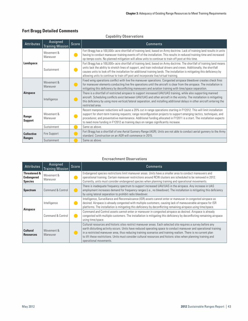
Fort Bragg Detailed CommentsCapability Observations
Attributes Assigned Training Mission Score Comments
Landspace
Movement & Maneuver
hFort Bragg has a 100,000+ acre shortfall of training land, based on Army doctrine. Lack of training land results in units having to conduct maneuver training events off of the installation. This results in reduced training time and increased op-tempo costs. No planned mitigation will allow units to continue to train off post at this time.
Sustainment h
Fort Bragg has a 100,000+ acre shortfall of training land, based on Army doctrine. The shortfall of training land means units lack the ability to stretch lines of support, and train individual drivers and crews. Additionally, the shortfall causes units to look off the installation for additional training lands. The installation is mitigating this deficiency by allowing units to continue to train off post and incorporate live/virtual training.
Airspace
Movement & Maneuver
hFixed wing operations conflict with live fire maneuver operations. Congested airspace bleedover creates check fires for maneuver elements conducting live fire operations until the aircraft is clear from the airspace. The installation is mitigating this deficiency by deconflicting maneuvers and aviation training with time/space separation.
Intelligence h
There is a shortfall of restricted airspace to support increased UAV/UAS training, while also supporting manned aircraft. Scheduling conflicts exist between UAV/UAS and other aircraft in the vicinity. The installation is mitigating this deficiency by using more vertical/lateral separation, and installing additional delays in other aircraft entering the restricted area.
Range Support
Movement & Maneuver
h
Recent manpower reductions will cause a 20% cut in range operations starting in FY2012. This will limit installation support for short-term training requests; range reconfiguration projects to support emerging tactics, techniques, and procedures; and preventative maintenance. Additional funding allocated in FY2011 is a start. The installation expects to need more funding in FY2012 as training days on ranges significantly increase.
Sustainment h Same as above.
Collective Ranges
Fire Support h Fort Bragg has a shortfall of one Aerial Gunnery Range (AGR). Units are not able to conduct aerial gunnery to the Army standard. Construction on an AGR will commence in 2015.
Sustainment h Same as above.
Encroachment Observations
Attributes Assigned Training Mission Score Comments
Threatened & Endangered Species
Movement & Maneuver
hEndangered species restrictions limit maneuver areas. Units have a smaller area to conduct maneuvers and operational training. Certain maneuver restrictions around RCW clusters are scheduled to be removed in 2012. Currently, units must consider endangered species when planning training and operational movements.
Spectrum Command & Control hThere is inadequate frequency spectrum to support increased UAV/UAS in the airspace. Any increase in UAS employment increases demand for frequency ranges (i.e., no bleedover). The installation is mitigating this deficiency by using lateral separation to prohibit radio bleedover.
Airspace
Intelligence hIntelligence, Surveillance and Reconnaissance (ISR) assets cannot enter or maneuver in congested airspace as desired. Airspace is already congested with multiple customers, causing lack of maneuverable airspace for ISR platforms. The installation is mitigating this deficiency by deconflicting remaining airspace using time/space.
Command & Control hCommand and Control assets cannot enter or maneuver in congested airspace as desired. Airspace is already congested with multiple customers. The installation is mitigating this deficiency by deconflicting remaining airspace using time/space.
Cultural Resources
Movement & Maneuver
h
Cultural resources and historic sites restrict maneuver areas. Each selected site requires a survey before any earth disturbing activity occurs. Units have reduced operating space to conduct maneuver and operational training in a restricted maneuver area, thus reducing training scenarios and training realism. There is no current plan to lift these restrictions. Units must consider cultural resources and historic sites when planning training and operational movements.

Chapter 3: Adequacy of Existing Range Resources to Meet Training Requirements
| 2012 Sustainable Ranges Report44 May 2012
Figure 3-10 Army Capability and Encroachment Assessment Detail (continued)
Fort Campbell Assessment Details
Range Mission Description
Fort Campbell is a power projection platform, strategically located on the Tennessee/Kentucky State line. Fort Campbell possesses the capability to deploy mission-ready contingency forces by air, rail, highway, and inland waterway. Fort Campbell develops and maintains Live Fire Maneuver Ranges and Training Areas that support the Senior Commander’s Mission Essential Training Tasks List (METTL). Fort Campbell is the home of the 101st Airborne Division (Air Assault) and two Special Operations Command units, the 5th Special Forces Group, and the 160th Special Operations Aviation Regiment. Additionally, Fort Campbell is home to the 86th Combat Support Hospital, the 52nd Ordnance Command, the 716th MP Battalion, and sizable Medical and Dental activities. Fort Campbell provides company level maneuver training and mobilization support for numerous Army National Guard and Army Reserve units.
Capability Data Encroachment Data
Mission Areas
Capability Attributes
Land
spac
e
Airs
pace
Seas
pace
Unde
rsea
spac
e
Targ
ets
Thre
ats
Scor
ing
&
Feed
back
Sys
tem
Infra
stru
ctur
e
Rang
e Su
ppor
t
Smal
l Arm
s Ra
nges
Colle
ctiv
e Ra
nges
MOU
T Fa
cilit
ies
Suite
of R
ange
s
Movement & Maneuver
h h h h h h h h h
Fire Support h h h h h h h h
Intelligence h h h h h h
Sustainment h h h h h h
Command & Control
h h h h h h
Protection h h h h h h h
Legend FMC PMC NMC
Mission Areas
Encroachment Factors
Thre
aten
ed a
nd
Enda
nger
ed S
peci
es
Mun
ition
s Res
trict
ions
Spec
trum
Mar
itim
e Su
stai
nabi
lity
Airs
pace
Air Q
ualit
y
Noi
se R
estri
ctio
ns
Adja
cent
Lan
d Us
e
Cultu
ral R
esou
rces
Wat
er Q
ualit
y/Su
pply
Wet
land
s
Rang
e Tr
ansi
ents
Movement & Maneuver
h h h h h h h h
Fire Support h h h h h h h h
Intelligence h h h h h h h
Sustainment h h h h h
Command Control
h h h h h h
Protection h h h h h h h
Legend Minimal Moderate Severe
Capability Chart and Scores Encroachment Chart and Scores
19%
81%
9.05
0 2 4 6 8 10
2%
98%
9.88
0 2 4 6 8 10
Summary Observations Summary Observations
The most severe impact to mission is caused by a shortfall of Range Support funding. While several mission areas are impacted by capability shortfalls, Movement & Maneuver is most severely impacted due to a shortfall of maneuver training land, lack of updated aviation target systems, Range Support funding shortfalls, and a shortage of Small Arms Ranges.
There is minimal impact to the mission areas due to encroachment factors. The presence of threatened and endangered species on the installation has a minimum impact to the Fire Support mission, due to restrictions on mowing for fire safety and visibility on the ranges.

Chapter 3: Adequacy of Existing Range Resources to Meet Training Requirements
2012 Sustainable Ranges Report | 45May 2012
Fort Campbell Detailed CommentsCapability Observations
Attributes Assigned Training Mission Score Comments
LandspaceMovement & Maneuver
h
There is a shortfall of available maneuver training land to meet doctrinal maneuver training requirements. Unit maneuver training is limited and movement is constrained to short 1-3 kilometer movements, depending on which training area the unit is assigned to. Simultaneous maneuvering for multiple, company sized units at doctrinal distances is constrained. Op-tempo costs are increased for units that travel to other locations to accomplish training events. Fort Campbell is partnering with Fort Knox for training allocation of maneuver land and ranges.
AirspaceMovement & Maneuver
hThere is limited controlled airspace over the installation. Limited airspace restricts the ability of units to conduct air training exercises to doctrinal standards in terms of dispersion, flight techniques, and integration with other assets, such as UAS. Fort Campbell is partnering with Fort Knox and other training sites to meeting training needs.
Scoring & Feedback System
Movement & Maneuver
h
The installation does not have an assigned Aviation Weapon Scoring System (AWSS) to support the two Combined Aviation Brigades and Task Force 160, Special Operations Aviation Regiment. Weapons qualification is dependent on subjective scoring (e.g., line of sight) that does not meet Army standards for qualification. Aviation units do not get consistently accurate feedback when qualifying. The Army has scheduled a rotating AWSS for temporary use at the installation.
Range Support
Movement & Maneuver
hRecent manpower reductions will cause a 20% cut in range operations starting in FY2012. This will limit installation support for short-term training requests; range reconfiguration projects to support emerging tactics, techniques, and procedures; and preventative maintenance.
Fire Support h Same as above.Sustainment h Same as above.
Small Arms Ranges
Movement & Maneuver
hThe installation has a deficit of two machine gun ranges and three small arms ranges in FY2011. Unit training time is reduced and op-tempo costs are increased for units that have to travel to other locations to accomplish training events. Military Construction, Army (MCA) funding is programmed in FY2016 and FY2017 to construct additional ranges.
Sustainment h Same as above.
Encroachment Observations
Factors Assigned Training Mission Score Comments
Threatened & Endangered Species
Fire Support h
The Henslow’s and Bachman’s Sparrow nesting habitat is present in the training area. During May-August, training land management actions (e.g., mowing, vegetation removal) are restricted and training use is reduced due to safety concerns (e.g., fire hazards, visibility). The installation is coordinating with regional U.S. Fish and Wildlife Service elements to minimize restrictions and address training impacts.
Fort Campbell Assessment Details
Historical Information, Results, and Future Projections Historical Information, Results, and Future ProjectionsCalendar Year 2008 2009 2010 2011 Calendar Year 2008 2009 2010 2011
Capability Scores 5.22 5.22 7.00 9.05 Encroachment Scores 10.00 10.00 10.00 9.88
Capabilities have generally improved at Fort Campbell over the past several years. Range support funding levels have increased and Fort Campbell has mitigated MOUT facility throughput, shortfalls internally. Shoot-house construction currently meets training needs, but if lead-free slug (LFS) fielding takes place to support Home Station Training, there will likely be an impact to the installation’s capability to meet requirements for MOUT Facility throughput, due to to concerns about use of the LFS in sandfilled shoot-houses. Lack of restricted airspace continues to be a concern and will limit the installation’s ability to replicate the operational environment for Warrior UAS training in FY2012 when the system is fielded.
Encroachment factors have not historically impacted the mission at Fort Campbell. Minimal impacts resulting from rare species habitat on the installation have developed over the past year, but are being managed successfully through coordination with USFWS. Current impacts are expected to be resolved and future impacts are not anticipated. Fort Campbell has also worked to actively implement the Army Compatible Use Buffer (ACUB) Program to ensure encroachment does not impact the future mission of the installation. Current ACUB efforts are focused on protecting the flight approach of the installation’s primary operational airfield, Campbell Army Airfield, and buffering the small arms impact area to ensure long-term capability to support the training mission.

Chapter 3: Adequacy of Existing Range Resources to Meet Training Requirements
| 2012 Sustainable Ranges Report46 May 2012
Figure 3-10 Army Capability and Encroachment Assessment Detail (continued)
Fort Carson Assessment Details
Range Mission Description
Fort Carson and Pinon Canyon Maneuver Site (PCMS) provide major training facilities (339,000 acres of training land, 92 ranges, 4 layers of restricted airspace) to support and enable relevant and realistic training for Fort Carson’s primary users: 4th Infantry Division (Mechanized)-1HBCT, 2HBCT, 3HBCT, 4IBCT; 43rd Sustainment Brigade; 10th Special Forces Group; 1/2 Attack Helicopter Battalion; and 71st EOD Group.
Capability Data Encroachment Data
Mission Areas
Capability Attributes
Land
spac
e
Airs
pace
Seas
pace
Unde
rsea
spac
e
Targ
ets
Thre
ats
Scor
ing
&
Feed
back
Sys
tem
Infra
stru
ctur
e
Rang
e Su
ppor
t
Smal
l Arm
s Ra
nges
Colle
ctiv
e Ra
nges
MOU
T Fa
cilit
ies
Suite
of R
ange
sMovement & Maneuver
h h h h h h h h
Fire Support h h h h h h h h
Intelligence h h h h h h
Sustainment h h h h h h h
Command & Control
h h h h h h
Protection h h h h h h h
Legend FMC PMC NMC
Mission Areas
Encroachment Factors
Thre
aten
ed a
nd
Enda
nger
ed S
peci
es
Mun
ition
s Res
trict
ions
Spec
trum
Mar
itim
e Su
stai
nabi
lity
Airs
pace
Air Q
ualit
y
Noi
se R
estri
ctio
ns
Adja
cent
Lan
d Us
e
Cultu
ral R
esou
rces
Wat
er Q
ualit
y/Su
pply
Wet
land
s
Rang
e Tr
ansi
ents
Movement & Maneuver
h h h h h h h h h h h
Fire Support h h h h h h h h h h
Intelligence h h h h h h h h h
Sustainment h h h h h h
Command Control
h h h h h h h
Protection h h h h h h h h h
Legend Minimal Moderate Severe
Capability Chart and Scores Encroachment Chart and Scores
10%
90%
9.52
0 2 4 6 8 10
2%2%
96%
9.71
0 2 4 6 8 10
Summary Observations Summary Observations
The most adverse impacts to mission are caused by Landspace (land shortfalls) and inadequate Range Support (staffing levels). While several mission areas are impacted by capability shortfalls, Movement & Maneuver is most adversely impacted due to excessive overtime costs associated with inadequate range staffing levels and lack of restricted airspace at PCMS, impacting military units’ abilities to train with UAS as they would in theater.
There is minimal impact to the mission areas due to encroachment factors. Small workarounds are utilized to avoid adverse impacts from the majority of the encroachment factors. The presence of unsurveyed areas with potential cultural resources are the primary encroachment factor that adversely impacts military training at Fort Carson and PCMS, due to the fact that unsurveyed training lands are deemed “for dismounted training only” until they can be surveyed.
Historical Information, Results, and Future Projections Historical Information, Results, and Future ProjectionsCalendar Year 2008 2009 2010 2011 Calendar Year 2008 2009 2010 2011
Capability Scores 6.67 6.67 7.22 9.29 Encroachment Scores 9.24 9.24 10.00 9.71
Capabilities have generally improved at Fort Carson and PCMS over the past several years. The use of Military Construction projects and self help assets have postured the installation at an adequate readiness level to support the training throughput requirements of current stationing levels. It is anticipated that the most critical shortfall, Range Support (personnel) will not improve in the near term, due to recent manpower reductions that will cause a 20% cut in range operations starting in FY2012. The ability to obtain restricted airspace over PCMS will be a challenge, and it is anticipated that this lack of restricted airspace will cause future capability shortfalls as additional UAS are fielded in the outyears.
Encroachment factors have not historically had a significant impact on the mission at Fort Carson and PCMS. Fort Carson is re-evaluating procedures for planning/implementing training events to ensure all regulatory requirements, including protection of Cultural Resources, are being met. The use of best management practices in sustaining the training lands has also contributed to additional lands being added back into the training inventory. Additionally, Fort Carson has been able to prevent encroachment impacts from adjacent land use, due to implementation of the Army Compatible Use Buffer (ACUB) Program. Given the fact that communities near Fort Carson are aggressively promoting development, it is vital that the ACUB Program continue to be funded to prevent incompatible development around the installation that would negatively impact the training mission.

Chapter 3: Adequacy of Existing Range Resources to Meet Training Requirements
2012 Sustainable Ranges Report | 47May 2012
Fort Carson Detailed CommentsCapability Observations
Attributes Assigned Training Mission Score Comments
Landspace Sustainment h
Fort Carson and PCMS have a doctrinal training land shortfall documented in accordance with AR 350-19. As units re-deploy for theater, Brigade and Battalion sized elements will not have adequate training land to maneuver to doctrinal standards simultaneously. Given current deployment rotations, the training land shortfall is not causing an adverse impact to training. The 4ID Commanding General’s guidance is to perform Brigade level maneuver and Batallion level live fire at the Combat Training Centers. This guidance will relieve the shortfall of required doctrinal training land.
AirspaceMovement & Maneuver
h
PCMS currently has no restricted airspace and cannot support UAS training above Raven at 1500ft AGL. Units cannot use other UAS assets and, therefore, cannot train as they fight. The installation is executing the necessary steps and procedures to seek to obtain restricted airspace. Meanwhile, units execute UAS training at Fort Carson and simulate UAS operations at PCMS.
Range Support
Movement & Maneuver
h Recent manpower reductions will cause a 20% cut in range operations starting in FY2012. This will create excessive overtime requirements to sustain prolonged training and enable support of mission requirements.
Sustainment h Same as above.
Encroachment Observations
Factors Assigned Training Mission Score Comments
Cultural Resouces
Movement & Maneuver
Fort Carson and PCMS possess training lands that have not been surveyed for cultural resources, and training on this land is limited to dismounted training only. Restrictions cause limitations to large scale maneuver exercises. Additionally, all efforts to utilize restricted areas for training require time and resources to work through the Section 106 consultation process. Fort Carson is slowly working towards 100% survey completion. The installation is also working towards a Programmatic Agreement with the State Historic Property Office to ease the burden and overhead of all efforts going through the Section 106 consultation process.
Sustainment Same as above.

Chapter 3: Adequacy of Existing Range Resources to Meet Training Requirements
| 2012 Sustainable Ranges Report48 May 2012
Figure 3-10 Army Capability and Encroachment Assessment Detail (continued)
Fort Drum Assessment Details
Range Mission Description
Fort Drum provides major training facilities to support deployment training and mobilization for active and reserve units from all Services in training at Fort Drum, and planning and support for their mobilization. Primary training units include the 10th Mountain Division (LI), the 7th Engineer Battalion, the 91st Military Police Battalion, and multiple Reserve component units. Fort Drum’s ranges and training areas also support two institutional elements: the Light Fighters School and the Non Commissioned Officers (NCO) Academy. The NCO Academy uses the training areas to conduct Warrior Leader courses, and the Light Fighters School uses the training areas to conduct field training exercises. The installation’s numerous live fire ranges support weapons familiarization training and qualification. The large caliber facilities can also support collective live fire training events. The capabilities available on the installation to support requirements by the Armed Forces of the United States is visible by the presence of all Services that train on Fort Drum, including, but not limited to, local and Federal law enforcement agencies as well as those supporting the local communities. The installation’s air to ground range provides joint training integration for Army, Marine, Air Force, SOCOM, National Guard, and USAR.
Capability Data Encroachment Data
Mission Areas
Capability Attributes
Land
spac
e
Airs
pace
Seas
pace
Unde
rsea
spac
e
Targ
ets
Thre
ats
Scor
ing
&
Feed
back
Sys
tem
Infra
stru
ctur
e
Rang
e Su
ppor
t
Smal
l Arm
s Ra
nges
Colle
ctiv
e Ra
nges
MOU
T Fa
cilit
ies
Suite
of R
ange
s
Movement & Maneuver
h h h h h h h h h
Fire Support h h h h h h h h
Intelligence h h h h h h
Sustainment h h h h h h h
Command & Control
h h h h h h
Protection h h h h h h h
Legend FMC PMC NMC
Mission Areas
Encroachment Factors
Thre
aten
ed a
nd
Enda
nger
ed S
peci
es
Mun
ition
s Res
trict
ions
Spec
trum
Mar
itim
e Su
stai
nabi
lity
Airs
pace
Air Q
ualit
y
Noi
se R
estri
ctio
ns
Adja
cent
Lan
d Us
e
Cultu
ral R
esou
rces
Wat
er Q
ualit
y/Su
pply
Wet
land
s
Rang
e Tr
ansi
ents
Movement & Maneuver
h h h h h h h h
Fire Support h h h h h h h h
Intelligence h h h h h h h
Sustainment h h h h
Command Control
h h h h h
Protection h h h h h h h
Legend Minimal Moderate Severe
Capability Chart and Scores Encroachment Chart and Scores
16%
84%
9.19
0 2 4 6 8 10
100%
10.00
0 2 4 6 8 10
Summary Observations Summary Observations
The most severe impact to mission is caused by a shortfall of Range Support funding. While several mission areas are impacted by capability shortfalls, Movement & Maneuver and Sustainment attributes are most severely impacted due to a shortfall of maneuver training land, lack of restricted airspace, Range Support funding shortfalls, and inadequate density of Multi-Purpose Machine Gun (MPMG) and Basic 10/25 Meter ranges. Currently, the use of range dispersion and range alignment allows Fort Drum to simultaneously support up to three separate units conducting small arms marksmanship and/or qualification training.
There is minimal impact to the mission areas due to encroachment factors, although the presence of threatened and endangered species on the installation has no significant, current impact on the training mission. Fort Drum is the location of at least one maternity colony of the federally endangered Indiana Bat. In addition to this one federally-listed species, there are 28 state-listed wildlife species, and 22 state-listed rare plant species. The known Indiana Bat colony is mostly protected through the establishment of a Bat Conservation Area: 2,200 acres of relatively undeveloped land in the Cantonment Area.
Chapter 3: Adequacy of Existing Range Resources to Meet Training Requirements
2012 Sustainable Ranges Report | 49May 2012
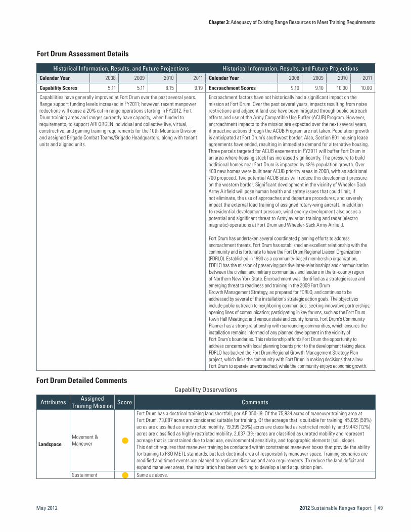
Fort Drum Assessment Details
Historical Information, Results, and Future Projections Historical Information, Results, and Future ProjectionsCalendar Year 2008 2009 2010 2011 Calendar Year 2008 2009 2010 2011
Capability Scores 5.11 5.11 8.15 9.19 Encroachment Scores 9.10 9.10 10.00 10.00
Capabilities have generally improved at Fort Drum over the past several years. Range support funding levels increased in FY2011; however, recent manpower reductions will cause a 20% cut in range operations starting in FY2012. Fort Drum training areas and ranges currently have capacity, when funded to requirements, to support ARFORGEN individual and collective live, virtual, constructive, and gaming training requirements for the 10th Mountain Division and assigned Brigade Combat Teams/Brigade Headquarters, along with tenant units and aligned units.
Encroachment factors have not historically had a significant impact on the mission at Fort Drum. Over the past several years, impacts resulting from noise restrictions and adjacent land use have been mitigated through public outreach efforts and use of the Army Compatible Use Buffer (ACUB) Program. However, encroachment impacts to the mission are expected over the next several years, if proactive actions through the ACUB Program are not taken. Population growth is anticipated at Fort Drum’s southwest border. Also, Section 801 housing lease agreements have ended, resulting in immediate demand for alternative housing. Three parcels targeted for ACUB easements in FY2011 will buffer Fort Drum in an area where housing stock has increased significantly. The pressure to build additional homes near Fort Drum is impacted by 48% population growth. Over 400 new homes were built near ACUB priority areas in 2008, with an additional 700 proposed. Two potential ACUB sites will reduce this development pressure on the western border. Significant development in the vicinity of Wheeler-Sack Army Airfield will pose human health and safety issues that could limit, if not eliminate, the use of approaches and departure procedures, and severely impact the external load training of assigned rotary-wing aircraft. In addition to residential development pressure, wind energy development also poses a potential and significant threat to Army aviation training and radar (electro magnetic) operations at Fort Drum and Wheeler-Sack Army Airfield.
Fort Drum has undertaken several coordinated planning efforts to address encroachment threats. Fort Drum has established an excellent relationship with the community and is fortunate to have the Fort Drum Regional Liaison Organization (FDRLO). Established in 1990 as a community-based membership organization, FDRLO has the mission of preserving positive inter-relationships and communication between the civilian and military communities and leaders in the tri-county region of Northern New York State. Encroachment was identified as a strategic issue and emerging threat to readiness and training in the 2009 Fort Drum Growth Management Strategy, as prepared for FDRLO, and continues to be addressed by several of the installation’s strategic action goals. The objectives include public outreach to neighboring communities; seeking innovative partnerships; opening lines of communication; participating in key forums, such as the Fort Drum Town Hall Meetings; and various state and county forums. Fort Drum’s Community Planner has a strong relationship with surrounding communities, which ensures the installation remains informed of any planned development in the vicinity of Fort Drum’s boundaries. This relationship affords Fort Drum the opportunity to address concerns with local planning boards prior to the development taking place. FDRLO has backed the Fort Drum Regional Growth Management Strategy Plan project, which links the community with Fort Drum in making decisions that allow Fort Drum to operate unencroached, while the community enjoys economic growth.
Fort Drum Detailed CommentsCapability Observations
Attributes Assigned Training Mission Score Comments
LandspaceMovement & Maneuver
h
Fort Drum has a doctrinal training land shortfall, per AR 350-19. Of the 75,934 acres of maneuver training area at Fort Drum, 73,887 acres are considered suitable for training. Of the acreage that is suitable for training, 45,055 (59%) acres are classified as unrestricted mobility, 19,399 (26%) acres are classified as restricted mobility, and 9,443 (12%) acres are classified as highly restricted mobility. 2,037 (3%) acres are classified as unrated mobility and representacreage that is constrained due to land use, environmental sensitivity, and topographic elements (soil, slope). This deficit requires that maneuver training be conducted within constrained maneuver boxes that provide the ability for training to FSO METL standards, but lack doctrinal area of responsibility maneuver space. Training scenarios are modified and timed events are planned to replicate distance and area requirements. To reduce the land deficit and expand maneuver areas, the installation has been working to develop a land acquisition plan.
Sustainment h Same as above.

Chapter 3: Adequacy of Existing Range Resources to Meet Training Requirements
| 2012 Sustainable Ranges Report50 May 2012
Figure 3-10 Army Capability and Encroachment Assessment Detail (continued)
Capability Observations
Attributes Assigned Training Mission Score Comments
AirspaceMovement & Maneuver
h
The restricted airspace available does not meet the ceiling requirements for high-angle weapon systems, such as 155mm and Stinger. Lack of required airspace results in the training event becoming an isolated event, rather than a combined arms exercise thereby reducing training realism. The Fort Drum Range Support Branch has not pursued requirements for extended airspace, but will require coordination with Army Headquarters, IMCOM, and FAA to determine feasibility and benefits to training in FY2012–FY2013.
Fire Support h Same as above.
Range Support
Movement & Maneuver
h
Recent manpower reductions will cause a 20% cut in range operations starting in FY2012. This will limit installation support for short-term training requests; range reconfiguration projects to support emerging tactics, techniques, and procedures; and preventative maintenance. In anticipation of fiscal year funding shortfalls, the Range Support Branch will prioritize resources and assets to the training community, based on the priority established by the Senior Commander in support of ARFORGEN. Priorities will be determined and the essential training requirements will be supported; all other requirements will only be supported if the resources and assets are available. Currently, with the contribution of Contingency Operation funds to support ARFORGEN training requirements, no identified training requirements have been refused.
Sustainment h Same as above.
Small Arms Ranges
Sustainment h
Use of the 40mm MK19 Grenade Training Round reduces the availability of maneuver space until the rounds have been cleared and recovered. It is manpower intensive to clear and recover the land after use, thus reducing training time. As the MK19 has been identified as a minimal hazard training round, the Army will continue to recover and clear ranges where it is used to ensure a safe training environment is maintained and maneuver land is available for training.
Fort Drum Detailed Comments

Chapter 3: Adequacy of Existing Range Resources to Meet Training Requirements
2012 Sustainable Ranges Report | 51May 2012
This Page is Intentionally Left Blank.
Chapter 3: Adequacy of Existing Range Resources to Meet Training Requirements
| 2012 Sustainable Ranges Report52 May 2012
Figure 3-10 Army Capability and Encroachment Assessment Detail (continued)
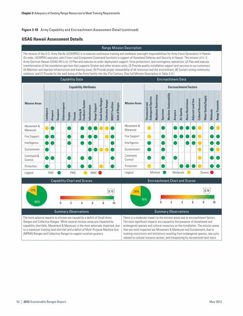
USAG Hawaii Assessment Details
Range Mission Description
The mission of the U.S. Army Pacific (USARPAC) is to execute continuous training and readiness oversight responsibilities for Army Force Generation in Hawaii. On order, USARPAC executes Joint Force Land Component Command functions in support of Homeland Defense and Security in Hawaii. The mission of U. S. Army Garrison Hawaii (USAG-HI) is to: (1) Plan and execute on-order deployment support, force protections, and contingency operations; (2) Plan and execute transformation of the installation garrison that supports Stryker and other mission units; (3) Provide quality installation support and services to our customers; (4) Maintain and improve infrastructure and training areas; (5) Provide proper stewardship of all resources and the environment; (6) Sustain strong community relations; and (7) Provide for the well-being of the Army Family into the 21st Century. (See full Mission Description in Table 3-4.)
Capability Data Encroachment Data
Mission Areas
Capability Attributes
Land
spac
e
Airs
pace
Seas
pace
Unde
rsea
spac
e
Targ
ets
Thre
ats
Scor
ing
&
Feed
back
Sys
tem
Infra
stru
ctur
e
Rang
e Su
ppor
t
Smal
l Arm
s Ra
nges
Colle
ctiv
e Ra
nges
MOU
T Fa
cilit
ies
Suite
of R
ange
s
Movement & Maneuver
h h h h h h h h h
Fire Support h h h h h h h h
Intelligence h h h h h h
Sustainment h h h h h h
Command & Control
h h h h h h
Protection h h h h h h
Legend FMC PMC NMC
Mission Areas
Encroachment Factors
Thre
aten
ed a
nd
Enda
nger
ed S
peci
es
Mun
ition
s Res
trict
ions
Spec
trum
Mar
itim
e Su
stai
nabi
lity
Airs
pace
Air Q
ualit
y
Noi
se R
estri
ctio
ns
Adja
cent
Lan
d Us
e
Cultu
ral R
esou
rces
Wat
er Q
ualit
y/Su
pply
Wet
land
s
Rang
e Tr
ansi
ents
Movement & Maneuver
h h h h h h h h h
Fire Support h h h h h h h h h
Intelligence h h h h h h h h
Sustainment h h h h h
Command Control
h h h h h h
Protection h h h h h h h h
Legend Minimal Moderate Severe
Capability Chart and Scores Encroachment Chart and Scores
17%
83%
9.15
0 2 4 6 8 10
24%
76%
8.78
0 2 4 6 8 10
Summary Observations Summary Observations
The most adverse impacts to mission are caused by a deficit of Small Arms Ranges and Collective Ranges. While several mission areas are impacted by capability shortfalls, Movement & Maneuver is the most adversely impacted, due to a maneuver training land shortfall and a deficit of Multi-Purpose Machine Gun (MPMG) Ranges and Collective Ranges to support aviation gunnery.
There is a moderate impact to the mission areas due to encroachment factors. The most significant impacts are caused by the presence of threatened and endangered species and cultural resources on the installation. The mission areas that are most impacted are Movement & Maneuver and Sustainment, due to training restrictions and limitations resulting from endangered species, law suits related to cultural resource access, and trespassing by recreational land users.

Chapter 3: Adequacy of Existing Range Resources to Meet Training Requirements
2012 Sustainable Ranges Report | 53May 2012
USAG Hawaii Assessment Details
Historical Information, Results, and Future Projections Historical Information, Results, and Future ProjectionsCalendar Year 2008 2009 2010 2011 Calendar Year 2008 2009 2010 2011
Capability Scores N/A N/A 7.67 8.66 Encroachment Scores N/A N/A 8.78 8.67
Capabilities have improved in Hawaii over the last two years. Range support funding improved slightly in FY2011 and additional manpower will be provided in FY2012, likely resulting in increased range capability in the outyears. A shortfall of an MPMG Range and Collective Range to support aviation gunnery has also continued to impact capability in Hawaii. A request to construct a standard design range has been submitted; collective range capability should improve in the outyears.
Encroachment factor impact on the mission in Hawaii has remained relatively stable over the past couple years. In the near future, the Biological Opinion (BO) will be amended so that live fire training with ball ammunition may be conducted while the burn index is in the red, thus increasing unit training capability. Two types of encroachment continue to impact Hawaii training areas and ranges. External encroachment factors, such as land development and increased housing construction, will continue to increase pressure on training areas and ranges in the future. With increased development near the installation boundaries, maneuver areas and impact areas are affected by restrictions on noise. Internal encroachment factors also impact the mission. Natural and cultural resource issues cause range closures and stop training. For example, when a threatened or endangered species is seen within a training area or range, all training is to stop, thus decreasing the capability associated with that range or training area.
USAG Hawaii Detailed CommentsCapability Observations
Attributes Assigned Training Mission Score Comments
LandspaceMovement & Maneuver
h
Increased maneuver throughput is required due to one Stryker Brigade Combat Team (SBCT) being based in Hawaii. As there is limited maneuver area on Oahu, logistically, SBCTs have to move by boat to Pohakuloa Training Area (PTA) to conduct a portion of their Misssion Essential Task List (METL) training. Even with PTA, Hawaii is still short on required maneuver land, because much of the area is not able to support the Stryker vehicle due to environmental no-go areas. Restrictions do not allow units to train to the Army standard. The installation will work through the constraints of the BO to allow for additional trainings areas to become available (i.e., expansion of PTA and the Keamuku maneuver area).
Small Arms Ranges
Movement & Maneuver
h There is a deficiency of one Machine Gun range. The installation is currently unable to conduct training to Army standards. This deficiency is mitigated by using alternative qualification standards (10 meter table).
Sustainment h Same as above.Protection h Same as above.
Collective Ranges
Movement & Maneuver
h There is a deficiency of Aviation Gunnery capability. The installation is currently unable to train to standard Gunnery table. Range managers have submitted a request to construct a standard design range.
Fire Support h Same as above.Sustainment h Same as above.
Encroachment Observations
Factors Assigned Training Mission Score Comments
Threatened & Endangered Species
Movement & Maneuver
h Endangered species habitat limits maneuver training areas to existing roads and trails, thus limiting training scenarios and training realism. The installation will continue to train within the restrictions set forth by the BO.
Fire Support h
The burn index limits training capabilities. The burn index, in conjunction with a limited impact area, causes throughput restrictions; live fire is limited to PTA and training round usage is restricted by caliber. The installation will continue to operate within the constraints of the BO for each of the training ranges; expand training options as they become available in accordance with the BO.
Protection h Same as above.
Cultural Resources
Movement & Maneuver
hResuming live fire training at Makua continues to be delayed, pending additional litigation over access to cultural sites. Live fire training activities are being conducted at alternate locations in Hawaii. Other training strategies are being pursued at Makua.
Fire Support h Same as above.Intelligence h Same as above.Sustainment h Same as above.Command & Control h Same as above.Protection h Same as above.
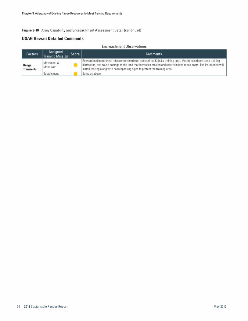
Chapter 3: Adequacy of Existing Range Resources to Meet Training Requirements
| 2012 Sustainable Ranges Report54 May 2012
Figure 3-10 Army Capability and Encroachment Assessment Detail (continued)
Encroachment Observations
Factors Assigned Training Mission Score Comments
Range Transients
Movement & Maneuver
hRecreational motorcross riders enter restricted areas of the Kahuku training area. Motorcross riders are a training distraction, and cause damage to the land that increases erosion and results in land repair costs. The installation will install fencing along with no trespassing signs to protect the training area.
Sustainment h Same as above.
USAG Hawaii Detailed Comments

Chapter 3: Adequacy of Existing Range Resources to Meet Training Requirements
2012 Sustainable Ranges Report | 55May 2012
This Page is Intentionally Left Blank.
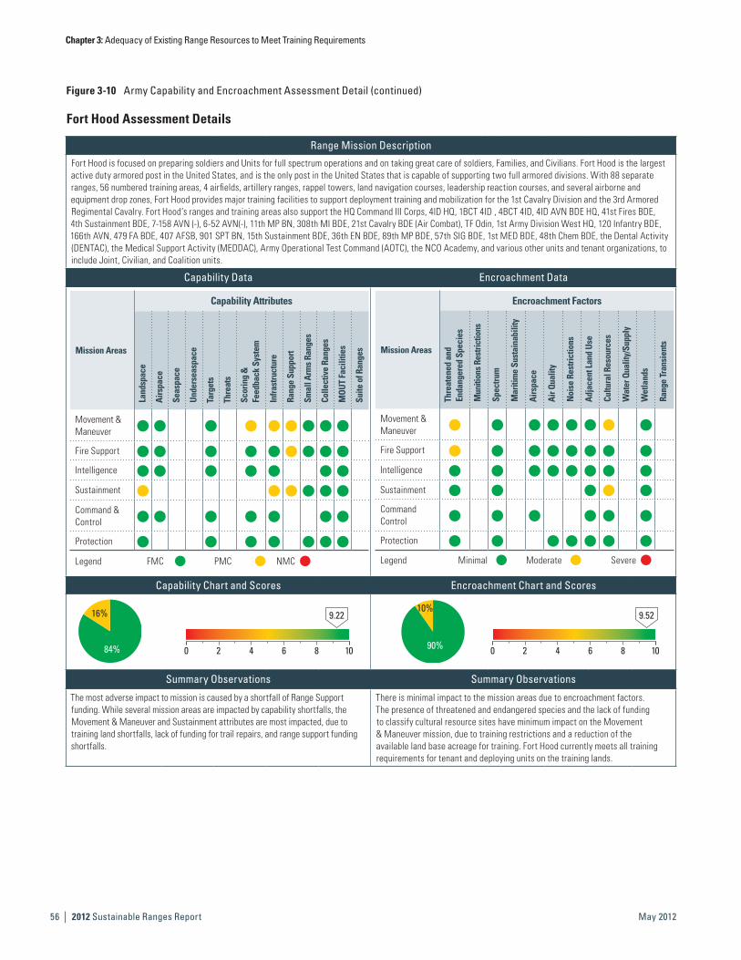
Chapter 3: Adequacy of Existing Range Resources to Meet Training Requirements
| 2012 Sustainable Ranges Report56 May 2012
Figure 3-10 Army Capability and Encroachment Assessment Detail (continued)
Fort Hood Assessment Details
Range Mission Description
Fort Hood is focused on preparing soldiers and Units for full spectrum operations and on taking great care of soldiers, Families, and Civilians. Fort Hood is the largest active duty armored post in the United States, and is the only post in the United States that is capable of supporting two full armored divisions. With 88 separate ranges, 56 numbered training areas, 4 airfields, artillery ranges, rappel towers, land navigation courses, leadership reaction courses, and several airborne and equipment drop zones, Fort Hood provides major training facilities to support deployment training and mobilization for the 1st Cavalry Division and the 3rd Armored Regimental Cavalry. Fort Hood’s ranges and training areas also support the HQ Command III Corps, 4ID HQ, 1BCT 4ID , 4BCT 4ID, 4ID AVN BDE HQ, 41st Fires BDE, 4th Sustainment BDE, 7-158 AVN (-), 6-52 AVN(-), 11th MP BN, 308th MI BDE, 21st Cavalry BDE (Air Combat), TF Odin, 1st Army Division West HQ, 120 Infantry BDE, 166th AVN, 479 FA BDE, 407 AFSB, 901 SPT BN, 15th Sustainment BDE, 36th EN BDE, 89th MP BDE, 57th SIG BDE, 1st MED BDE, 48th Chem BDE, the Dental Activity (DENTAC), the Medical Support Activity (MEDDAC), Army Operational Test Command (AOTC), the NCO Academy, and various other units and tenant organizations, to include Joint, Civilian, and Coalition units.
Capability Data Encroachment Data
Mission Areas
Capability Attributes
Land
spac
e
Airs
pace
Seas
pace
Unde
rsea
spac
e
Targ
ets
Thre
ats
Scor
ing
&
Feed
back
Sys
tem
Infra
stru
ctur
e
Rang
e Su
ppor
t
Smal
l Arm
s Ra
nges
Colle
ctiv
e Ra
nges
MOU
T Fa
cilit
ies
Suite
of R
ange
s
Movement & Maneuver
h h h h h h h h h
Fire Support h h h h h h h h h
Intelligence h h h h h h h
Sustainment h h h h h h
Command & Control
h h h h h h h
Protection h h h h h h h
Legend FMC PMC NMC
Mission Areas
Encroachment Factors
Thre
aten
ed a
nd
Enda
nger
ed S
peci
es
Mun
ition
s Res
trict
ions
Spec
trum
Mar
itim
e Su
stai
nabi
lity
Airs
pace
Air Q
ualit
y
Noi
se R
estri
ctio
ns
Adja
cent
Lan
d Us
e
Cultu
ral R
esou
rces
Wat
er Q
ualit
y/Su
pply
Wet
land
s
Rang
e Tr
ansi
ents
Movement & Maneuver
h h h h h h h h
Fire Support h h h h h h h h
Intelligence h h h h h h h h
Sustainment h h h h h
Command Control
h h h h h h
Protection h h h h h h h
Legend Minimal Moderate Severe
Capability Chart and Scores Encroachment Chart and Scores
16%
84%
9.22
0 2 4 6 8 10
10%
90%
9.52
0 2 4 6 8 10
Summary Observations Summary Observations
The most adverse impact to mission is caused by a shortfall of Range Support funding. While several mission areas are impacted by capability shortfalls, the Movement & Maneuver and Sustainment attributes are most impacted, due to training land shortfalls, lack of funding for trail repairs, and range support funding shortfalls.
There is minimal impact to the mission areas due to encroachment factors. The presence of threatened and endangered species and the lack of funding to classify cultural resource sites have minimum impact on the Movement & Maneuver mission, due to training restrictions and a reduction of the available land base acreage for training. Fort Hood currently meets all training requirements for tenant and deploying units on the training lands.
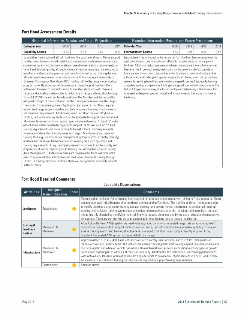
Chapter 3: Adequacy of Existing Range Resources to Meet Training Requirements
2012 Sustainable Ranges Report | 57May 2012
Fort Hood Assessment Details
Historical Information, Results, and Future Projections Historical Information, Results, and Future ProjectionsCalendar Year 2008 2009 2010 2011 Calendar Year 2008 2009 2010 2011
Capability Scores 5.33 5.33 7.44 9.22 Encroachment Scores 7.93 7.93 9.52 9.52
Capabilities have improved at Fort Hood over the past several years. Range support funding levels have increased slightly, and range modernization requirements are currently programmed. Range operations currently meet training requirements for tenant and deploying units, although maneuver requirements must be executed to modified standards and augmented with simulations and virtual training devices. Mobilizing unit requirements can only be met with the continued availability of Overseas Contingency Operations (OCO) funding. While the range modernization program currently addresses all deficiencies in range support facilities, there will remain the need to conduct training to modified standards with obsolete targets and operating systems, due to reductions in range modernization funding through FY2016. The current transformation of the Army has not decreased the assigned strength of the installation nor the training requirements for the ranges. The current 15 Brigade equivalent fighting force assigned to Fort Hood requires modernized range support facilities and technological advances, which increase the maneuver requirement. Additionally, when Fort Hood receives Strykers in FY2012, tank and maneuver trails will not be adequate to support their movement. Maneuver lanes and corridors require repairs and maintenance. At least 121 miles of tank trails will be need to be repaired to support the Strykers in FY2012. Unit training requirements will only continue to be met if there is funding available to manage and maintain training areas and ranges. Maintenance and repair of training land (e.g., woody species management, gully plugs/cross country mobility) and tank and maneuver trail repairs are not keeping pace with op-tempo and training requirements. Army training requirements continue to evolve quickly and preparation of land is required prior to training use. Although Integrated Training Area Management (ITAM) requirements are programmed, there will remain the need to acquire additional funds to meet land repairs to enable training through FY2016. If funding shortfalls continue, there will be significant capability impacts in the outyears.
Encroachment factor impact to the mission at Fort Hood has been reduced over the past several years, due to installation efforts to mitigate impacts from adjacent land use. Additional reductions in encroachment impacts are the result of a revised business rule. In previous years, restrictions on the use of smoke/obscurants in training events were being captured as an Air Quality encroachment factor and as a Threatened and Endangered Species encroachment factor, when the restrictions were only resulting from the presence of endangered species. Historically, training usage has worked as a parity for limiting endangered species habitat expansion. The lack of full spectrum training, due to unit deployment schedules, is likely to result in increased endangered species habitat and, thus, increased training restrictions in the future.
Fort Hood Detailed CommentsCapability Observations
Attributes Assigned Training Mission Score Comments
Landspace Sustainment h
There is a doctrinal shortfall of training land required for units to conduct maneuver training to Army standards. There are approximately 196,356 acres of unrestricted training land at Fort Hood. The training land shortfall requires units to modify doctrinal distances for training and use training land beyond normal timeframes, to conduct all required training events. Many training events must be conducted to modified standards, reducing training realism. Units are mitigating this shortfall by modifying their training with reduced distances and by the use of virtual and constructive simulations. There are currently no plans to acquire additional training land to reduce the shortfall.
Scoring & Feedback System
Movement & Maneuver
h
After Action Review (AAR) capabilities need to be upgraded on non-instrumented ranges. As an automated AAR capability is not available to support the Instrumented Force, units do not have the adequate capability to review/assess training events, and training effectiveness is reduced. Fort Hood is pursuing a recently acquired Army Standard Automated AAR system for legacy Multi Use Ranges.
InfrastructureMovement & Maneuver
h
Approximately 179 of 412 (43%) miles of tank trails are currently unserviceable, and 113 of 120 (98%) miles of maneuver trails are unserviceable. The lack of serviceable trails degrades unit training capabilities, and reduces and restricts logistic and wheeled vehicle operations. Unmaintained trails provide succession to woody species growth. Fort Hood is repairing up to 20 miles of tank trails annually. Additionally, the installation is increasing partnerships with Active Duty, Reserve, and National Guard Engineer units to provide trail repair services in FY2011 and FY2012. An increase in sustainment funding for tank trails is required to support training requirements.
Sustainment h Same as above.

Chapter 3: Adequacy of Existing Range Resources to Meet Training Requirements
| 2012 Sustainable Ranges Report58 May 2012
Figure 3-10 Army Capability and Encroachment Assessment Detail (continued)
Fort Hood Detailed CommentsCapability Observations
Attributes Assigned Training Mission Score Comments
Range Support
Movement & Maneuver
h
Recent manpower reductions will cause a 20% cut in range operations starting in FY2012. This will limit installation support for short-term training requests; range reconfiguration projects to support emerging tactics, techniques, and procedures; and preventative maintenance. Continue to assess range support contracts to identify costs reductions (including reducing the number of ranges available for training) for the Senior Commander to consider. The Range Control Branch has to use OCO funding to meet additional requirements for mobilization and deployment.
Fire Support h Same as above.Sustainment h Same as above.
Encroachment Observations
Factors Assigned Training Mission Score Comments
Threatened & Endangered Species
Movement & Maneuver
h
Core endangered species nesting seasons restrict training for 5 months of the year on 6.2% of the training areas. Core habitat (8,243 acres) is located on the east side of the installation in light training areas and results in significant restrictions during nesting season. Non Core habitat (43,952 acres) impacts both heavy and light training areas, but only restricts digging. Units are restricted in Core habitat during nesting season: no vehicles off road; no mounted training in trees; units cannot stay longer than 2 hours in habitat areas per day; no smoke/pyro within 100 meters of Core habitat, and no camouflage net use. Units are restricted from digging in Core and Non Core habitat areas year round. The installation has no plans to change Core habitat areas or restrictions. The Non Core habitat digging restriction is minimized through use of a one stop, digital dig request system, which provides no dig overlays for all training areas and allows trainers to plan and establish tactical defensive training.
Fire Support h Same as above.
Cultural Resources
Movement & Maneuver
h
Insufficient funding limits the ability to review and classify potential cultural resource sites. Sites cannot be classified as eligible or ineligible to support training and/or range upgrades; thus, these potential sites are not currently available for training. The Army will continue to work to make appropriate classifications so that training can be maximized on the installation. Appropriate mitigation strategies to avoid training shortfalls are ongoing.
Sustainment h Same as above.

Chapter 3: Adequacy of Existing Range Resources to Meet Training Requirements
2012 Sustainable Ranges Report | 59May 2012
This Page is Intentionally Left Blank.
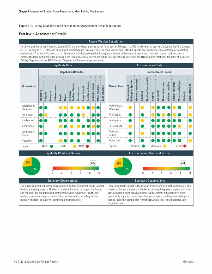
Chapter 3: Adequacy of Existing Range Resources to Meet Training Requirements
| 2012 Sustainable Ranges Report60 May 2012
Figure 3-10 Army Capability and Encroachment Assessment Detail (continued)
Fort Irwin Assessment Details
Range Mission Description
Fort Irwin and the National Training Center (NTC) is a world class training center for America’s Military. The NTC is a key part of the Army’s Combat Training Centers (CTCs). Training at NTC is focused on joint and combined arms training in multi-national venues across the full spectrum of conflict set in a contemporary operating environment. These training assets assist Commanders in developing trained, competent leaders and soldiers by presenting them with current problem sets to improve the force and prepare for success in the Global War on Terrorism and future joint battlefields. Fort Irwin and NTC supports rotational, tenant (11th Armored Calvary Regiment and the 916th Support Brigade), and Reserve component units.
Capability Data Encroachment Data
Mission Areas
Capability Attributes
Land
spac
e
Airs
pace
Seas
pace
Unde
rsea
spac
e
Targ
ets
Thre
ats
Scor
ing
&
Feed
back
Sys
tem
Infra
stru
ctur
e
Rang
e Su
ppor
t
Smal
l Arm
s Ra
nges
Colle
ctiv
e Ra
nges
MOU
T Fa
cilit
ies
Suite
of R
ange
sMovement & Maneuver
h h h h h h h h h h
Fire Support h h h h h h h h h
Intelligence h h h h h h h h h
Sustainment h h h h h h h h h
Command & Control
h h h h h h h h h h
Protection h h h h h h h
Legend FMC PMC NMC
Mission Areas
Encroachment Factors
Thre
aten
ed a
nd
Enda
nger
ed S
peci
es
Mun
ition
s Res
trict
ions
Spec
trum
Mar
itim
e Su
stai
nabi
lity
Airs
pace
Air Q
ualit
y
Noi
se R
estri
ctio
ns
Adja
cent
Lan
d Us
e
Cultu
ral R
esou
rces
Wat
er Q
ualit
y/Su
pply
Wet
land
s
Rang
e Tr
ansi
ents
Movement & Maneuver
h h h h h h h h h
Fire Support h h h h h h h h h
Intelligence h h h h h h h h h
Sustainment h h h h h h h h h
Command Control
h h h h h h h h h
Protection h h h h h h h h h
Legend Minimal Moderate Severe
Capability Chart and Scores Encroachment Chart and Scores
26%
74%
8.70
0 2 4 6 8 10
28%
72%
8.61
0 2 4 6 8 10
Summary Observations Summary Observations
The most significant impacts to mission are caused by insufficient Range Support funding and aging targetry. The lack of sustained funding to support the Range and Training Land Program significantly impacts unit movement. Insufficient funding to resource range instrumentation modernization, including live fire targetry, impacts the quality of combined arms maneuvers.
There is moderate impact to the mission areas due to encroachment factors. The presence of range transients is the factor causing the greatest impact to mission. While several mission areas are impacted, Movement & Maneuver is most significantly impacted due to loss of maneuver space resulting from endangered species, spectrum competition from the NASA station, limited airspace, and range transients.

Chapter 3: Adequacy of Existing Range Resources to Meet Training Requirements
2012 Sustainable Ranges Report | 61May 2012
Fort Irwin Detailed CommentCapability Observations
Attributes Assigned Training Mission Score Comments
Airspace Fire Support h
NTC must share airspace in the eastern and western expansion areas, limiting the amount and types of training that can be done in those areas. NTC shares the eastern expansion with FAA, limiting use above 16,000 feet AGL. This limitation restricts the ability to employ high Close Air Support and strategic level UAS. The western expansion is shared with China Lake NAWC and Edwards AFB, with NTC as the third priority user. This limits the ability of NTC to employ aviation assets when required to support maneuver training. NTC must work with te FAA and sister services to gain control of its airspace to enable training
Targets
Movement & Maneuver
h
The armor and infantry targets that support live fire training for rotational units are circa 1970. The ability of the targetry and range control operating system to meet Heavy Brigade Combat Team (HBCT) gunnery standards is not possible without major workarounds. The CTC Modernization Program is providing some additional targetry in the current POM cycle; however, 100% life cycle replacement is not provided for at this time.
Sustainment h Same as above.
Protection h
The armor and infantry targets that support live fire training for rotational units are circa 1970. The ability of the targetry and range control operating system to meet HBCT gunnery standards is not possible without major workarounds. The CTC Modernization Program is providing resources to sustain current targetry in POM 13-17 until life cycle replacement can be addressed.
ThreatsMovement & Maneuver
h
The Battle Effects Simulators (BES) that support live fire training for rotational units are circa 1970. The ability of the targetry and range control operating system to interface with BES is not possible without major workarounds The CTC Modernization Program is providing resources to sustain current BES in POM 13-17 cycle until life cycle replacement can be addressed.
Fort Irwin Assessment Details
Historical Information, Results, and Future Projections Historical Information, Results, and Future ProjectionsCalendar Year 2008 2009 2010 2011 Calendar Year 2008 2009 2010 2011
Capability Scores 7.45 7.45 7.84 8.70 Encroachment Scores 9.75 9.75 8.50 8.61
Historically, NTC training capability has improved over the past several years. Since 2004, NTC has made remarkable strides to populate the training area with MOUT training sites, emplaced to support current Overseas Contingency Operations in Iraq and Afghanistan. Other areas, such as range control and unexploded ordnance (UXO) clearing, have remained relatively constant in capability.
Two significant areas have shown degradation: installation ranges and Combat Training Center (CTC) required equipment. The installation ranges have had no significant resources applied to them for the last five years. They are inadequate for the installation mission, and in need of modernization and sustainment funding. Three of the six new range requirements that NTC submitted were supported in POM 12–16, but were subsequently postponed out of the current POM cycle. NTC has not previously received separate funding for range sustainment, resulting in further range degradation. Headquarters, Department of the Army, G-3 Training assessed and addressed critical shortfalls in POM 13-17, resulting in range sustainment funding being provided starting in FY2013.
The other major capability degradation is in the area of CTC infrastructure and equipment to support the NTC rotation training mission. In the past, CTC modernization has been underfunded and has impacted the upkeep of instrumentation, Tactical Engagement Simulation Systems, opposing force equipment, and live fire ranges at required capability to sustain training for rotating brigades. NTC is a member of the CTC Modernization Program and participates in the development and prioritization of CTC requirements. The Headquarters, Department of the Army, G-3 Training was successful in protecting FY2012–FY2017 CTC Modernization Program funding. As long as no future funding decrements occur, the program will be able to address aging targetry and instrumentation.
Fort Irwin and NTC remain capable of accomplishing the training mission, despite instances of increasing encroachment. Fort Irwin’s major encroachment issues center around three areas: spectrum, endangered species, and boundary issues.
NTC shares the electromagnetic spectrum with the NASA Goldstone Deep Space Communications Complex (GDSCC). NTC must tailor its use of the spectrum to accommodate NASA’s needs. This means limiting jamming training, requiring the testing of all systems before use at NTC, and limiting the areas where electronic emitters can be used. This encroachment will be most serious when the western expansion area is opened for training.
Endangered species provide the second major area of concern. NTC is affected by the federally-threatened Desert Tortoise and the endangered Lane Mountain Milk Vetch. These species have combined to require NTC to set aside over 40,000 acres of training land for habitat and significantly curtailed activities in several parts of the training area. Mitigation costs in the NTC land expansion have exceeded $75M and mitigation activities have added 10 years to the land expansion process, which has been ongoing since 1993. NTC actively works with the Department of the Interior, Bureau of Land Management, the California Department of Fish and Game, and other agencies to manage endangered species activities.
The third area of concern is the adjacent wilderness areas and occasional civilian incursion. Ongoing legislation will surround NTC with wilderness areas on three sides, and could result in training limitations. NTC is working with Army Headquarters to minimize these effects on the training mission.
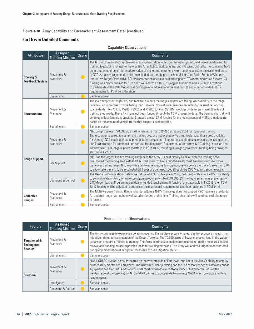
Chapter 3: Adequacy of Existing Range Resources to Meet Training Requirements
| 2012 Sustainable Ranges Report62 May 2012
Figure 3-10 Army Capability and Encroachment Assessment Detail (continued)
Capability Observations
Attributes Assigned Training Mission Score Comments
Scoring & Feedback System
Movement & Maneuver
h
The NTC instrumentation system requires modernization to account for new systems and increased demand for training feedback. Changes to the way the Army fights, modular units, and increased digital battle command have generated a requirement for modernization of the instrumentation system used to assist in the training of units at NTC. Area coverage needs to be increased, data throughput needs revisions, and Multi-Purpose Wireless Interactive Target System (MILES) instrumentation needs to be more capable. CTC Instrumentation System (IS) funding was protected in POM 13-17 and will address NTC IS as long as funding remains. NTC will continue to participate in the CTC Modernization Program to address and present critical and other unfunded ITESS requirements for POM consideration.
Sustainment h Same as above.
InfrastructureMovement & Maneuver
h
The main supply routes (MSRs) and tank trails within the range complex are failing. Accessibility to the range complex is compromised by the failing road network. Normal maintenance cannot bring the road network up to standards. PNs 75979, 75980, 75982, and 75983, totaling $21.8M, would provide for paving of 20 miles of training area roads. These PNs have not been funded through the POM process to date. The training shortfall will continue unless funding is provided. Standard annual SRM funding for the maintenance of MSRs is inadequate, based on the amount of vehicle traffic that supports each rotation.
Sustainment h Same as above.
Range Support
Movement & Maneuver
h
NTC comprises over 770,000 acres, of which more than 500,000 acres are used for maneuver training. The resources required to sustain the training area are not available. To effectively make these area available for training, NTC needs additional personnel for range control operations, additional communications equipment, and infrastructure for command and control. Headquarters, Department of the Army, G-3 Training assessed and addressed critical range support shortfalls in POM 13-17, resulting in range sustainment funding being provided starting in FY2013.
Fire Support h
NTC has the largest live fire training complex in the Army. Its past history as an air defense training base has littered the training area with UXO. NTC has few off limits dudded areas; most are used concurrently as maneuver training lanes. NTC requires additional resources to more adequately police the training areas for UXO to allow safe training to be accomplished. Funds are being pursued through the CTC Modernization Program.
Command & Control h
The Range Communication System was at the end of its life cycle in 2010, but is repairable until 2015. The ability to communicate within the range complex is a requirement IAW AR 385-63. The requirement was presented to CTC Modernization Program as a critical unfunded requirement. If funding is not available in FY2012, then POM 13-17 funding will be adjusted to address critical unfunded requirements and then realigned in POM 14-18.
Collective Ranges
Movement & Maneuver
hThe Multi-Purpose Training Range is outdated (circa 1987). The range does not support HBCT gunnery standards. An updated range has not been validated or funded at this time. Training shortfalls will continue until the range is funded.
Sustainment h Same as above.
Encroachment Observations
Factors Assigned Training Mission Score Comments
Threatened & Endangered Species
Movement & Maneuver
The Army continues to experience delays in opening the western expansion area, due to secondary impacts from litigation related to translocation of the Desert Tortoise. The 70,555 acres of heavy maneuver land in the western expansion area are off limits to training. The Army continues to implement required mitigation measures, based on available funding, to use expansion lands for training purposes. The Army will address litigation encountered during implementation of mitigation measures as such litigation occurs.
Sustainment Same as above.
Spectrum
Movement & Maneuver
NASA GDSCC (33,000 acres) is located on the western side of Fort Irwin, and limits the Army’s ability to employ all necessary electronics equipment. The Army must limit jamming and the use of many types of communications equipment and emitters. Additionally, units must coordinate with NASA GDSCC to limit emissions on the western side of the reservation. NTC and NASA need to cooperate to minimize NASA electronic noise limiting requirements.
Intelligence Same as above.
Command & Control Same as above.
Fort Irwin Detailed Comments

Chapter 3: Adequacy of Existing Range Resources to Meet Training Requirements
2012 Sustainable Ranges Report | 63May 2012
Fort Irwin Detailed Comments
Encroachment Observations
Factors Assigned Training Mission Score Comments
Airspace
Movement & Maneuver
NTC does not control the airspace over the eastern and western expansion areas. The eastern expansion area has a 16,000 foot ceiling. This limits the types of aircraft and missions that can be flown, in contrast to the installation proper, which is ceiling unlimited. The western expansion area airspace is chaired with China LakeNAWC and Edwards AFB, with NTC as the 3rd priority user of its own airspace. This limits the ability of NTC to flyArmy UAS and joint aircraft in support of brigade training. NTC is working with FAA and the R2502 JPPB to minimize training restrictions.
Fire Support Same as above.
Noise Restriction Fire Support
NTC live fire operations generate noise that can be heard across the eastern boundary. NTC receives complaints about live fire noise from residents who live in the vicinity of the eastern boundary. To mitigate this condition, NTC does not conduct live fire training in the eastern expansion area. NTC will continue to work with local communities on noise issues.
Cultural Resources
Movement & Maneuver
Fort Irwin has over 1,000 identified cultural sites in the maneuver area. The large number of sites and the rules for using these areas causes training to be impacted and selected critical areas to be identified as off limits to training because of cultural implications. NTC requires a significant cultural resources budget to manage these sites. NTC will continue to manage the impacts.
Fire Support Same as above.
Water Quality Supply
Sustainment
Fort Irwin has an estimated 40-year, non-replenishable water supply. NTC uses water wells to provide all water needs. As the training area has no reliable water supply to support training needs, all water must be transported to field locations. The amount and location of training are affected by the ability to transport and supply water for training units. Fort Irwin needs to be resourced to probe for additional water sources. Additionally, a tertiary water treatment facility (costs estimated at $100M) needs to be constructed so Fort Irwin can reclaim up to 60% of the one million gallons of water used daily. These measures will extend Fort Irwin’s viable service life indefinitely.
Range Transients
Movement & Maneuver
Approximately 225 miles of Fort Irwin’s boundary is contiguous to Death Valley National Park or publicly accessible areas. The ability of persons to enter Fort Irwin in an uncontrolled area causes problems for training. During maneuver and live fire training, the Army is required to pre-clear the training area of unauthorized personnel, using either ground or aerial patrols. Additionally, NTC has had many instances of ”scrappers” (unauthorized metal scavengers and thieves) entering the training area and collecting (stealing) both metal scrap and training equipment (targets, solar panels, copper wire). NTC patrols have stopped trucks loaded with unexploded ordnance that was collected from the impact areas, clearly presenting a safety concern. NTC requires adequate resources to fence the installation, and provide regular patrols to cover the training area to prevent unauthorized and dangerous access.
Fire Support Same as above.
Sustainment Same as above.
Protection Same as above.

Chapter 3: Adequacy of Existing Range Resources to Meet Training Requirements
| 2012 Sustainable Ranges Report64 May 2012
Figure 3-10 Army Capability and Encroachment Assessment Detail (continued)
Fort Lewis Assessment Details
Range Mission Description
Joint Base Lewis-McChord (JBLM) provides state-of-the-art training and infrastructure and fully capable mobilization and deployment operations for the Army, Navy, Air Force, and Marines. JBLM supports a myriad of tenant, non-tenant, and Reserve component forces, and supports a Mobilization mission that trains over 15,000 mobilizing soldiers annually. Additionally, JBLM provides support for ROTC Advanced Annual Summer Camp, “Warrior Forge.” Live fire ranges are capable of supporting individual, crew served, Stryker, and aerial gunnery (limited) as well as squad, platoon, and company maneuver live fire exercises. JBLM has approximately 68,000 acres of maneuver land. 88% of that land is designated for heavy use, and the remaining 12% is for heavy or light use. Additionally, there are 13,000 acres of dudded and non-dudded impact areas. 1st Army Training Guidance is that all CAT II and III units participate in some form of live fire exercise. The convoy live fire meets this requirement and IED-Defeat and Base Defense Training is available for all units. Specialized training is conducted based on unit requirements. Live fire training, and heavy and light maneuver capabilities are provided for I Corps (STB), 4/2 ID (SBCT), 3/2 ID (SBCT), 4/6 ACS, 17th Fires Brigade, 5/2 ID (SBCT), 555 Engineer Brigade, 201 Military Intelligence Brigade, 42 Military Police Brigade, 593 SB, 62 Medical Brigade, 51 Signal Battalion, 8th Brigade ROTC, 1SFG, and the 2/75 Ranger Battalion, as well as numerous Reserve, Guard, and sister service units.
Capability Data Encroachment Data
Mission Areas
Capability Attributes
Land
spac
e
Airs
pace
Seas
pace
Unde
rsea
spac
e
Targ
ets
Thre
ats
Scor
ing
&
Feed
back
Sys
tem
Infra
stru
ctur
e
Rang
e Su
ppor
t
Smal
l Arm
s Ra
nges
Colle
ctiv
e Ra
nges
MOU
T Fa
cilit
ies
Suite
of R
ange
s
Movement & Maneuver
h h h h h h h h h
Fire Support h h h h h h h h
Intelligence h h h h h h
Sustainment h h h h h h
Command & Control
h h h h h h
Protection h h h h h h h
Legend FMC PMC NMC
Mission Areas
Encroachment Factors
Thre
aten
ed a
nd
Enda
nger
ed S
peci
es
Mun
ition
s Res
trict
ions
Spec
trum
Mar
itim
e Su
stai
nabi
lity
Airs
pace
Air Q
ualit
y
Noi
se R
estri
ctio
ns
Adja
cent
Lan
d Us
e
Cultu
ral R
esou
rces
Wat
er Q
ualit
y/Su
pply
Wet
land
s
Rang
e Tr
ansi
ents
Movement & Maneuver
h h h h h h h h h
Fire Support h h h h h h h h
Intelligence h h h h h h h
Sustainment h h h h h
Command Control
h h h h h h
Protection h h h h h h h
Legend Minimal Moderate Severe
Capability Chart and Scores Encroachment Chart and Scores
33%
67%
8.33
0 2 4 6 8 10
29%
71%
8.57
0 2 4 6 8 10
Summary Observations Summary Observations
The most severe impacts to mission are caused by a shortfall in Range Support funding and lack of Small Arms Ranges and Collective Ranges. While several mission areas are impacted by capability shortfalls, Movement & Maneuver is the most severely impacted attribute, due to a shortfall of training land and ranges to support Stryker Brigades, damaged maneuver trails and roads that limit maneuver training and unit access to maneuver compartments, and a shortfall of range staff authorizations.
There is a moderate impact to the mission areas due to encroachment factors. The most significant impact is caused by the presence of threatened and endangered species on the installation. The mission areas that are most impacted are Movement & Maneuver and Fire Support, due to training restrictions and limitations resulting from endangered species and wetlands, limited airspace for artillery, noise issues, and unanticipated recreational land users.

Chapter 3: Adequacy of Existing Range Resources to Meet Training Requirements
2012 Sustainable Ranges Report | 65May 2012
Fort Lewis Assessment Details
Historical Information, Results, and Future Projections Historical Information, Results, and Future ProjectionsCalendar Year 2008 2009 2010 2011 Calendar Year 2008 2009 2010 2011
Capability Scores 7.67 7.67 6.56 8.33 Encroachment Scores 8.54 8.54 9.15 8.57
Capabilities have improved at Fort Lewis over the past several years. While range support funding improved slightly in FY2011, recent manpower reductions will cause a 20% cut in range operations starting in FY2012. A shortage of Small Arms Ranges and Collective Ranges has also continued to impact capability at Fort Lewis; however, new ranges are programmed for construction in FY2016 and FY2017, and should result in improved capability for both Small Arms and Collective Ranges in the outyears. Landspace and Airspace capability attributes will continue to be a challenge into the outyears, but the installation is working with FAA to mitigate airspace issues.
Encroachment factors have historically had a minor to moderate impact on the mission at Fort Lewis; however, it is very likely that four candidate species under the Endangered Species Act will be listed: the Taylor’s Checkerspot Butterfly, Mardon Skipper Butterfly, Streaked Horned Lark, and Roy Prairie Pocket Gopher. These species are found on the maneuver areas and on Ranges 74-76 of JBLM. The listing of the Taylor’s Checkerspot Butterfly will have a significant impact on maneuver training and restrictions on maneuver training will increase. The Army is currently pursuing an Army Compatible Use Buffer (ACUB) with the Nature Conservancy to offset potential impacts to training.
Impacts resulting from critical habitat and internal management restrictions on the installation have been fairly consistent for the past several years. Noise restrictions and adjacent land use impacts have caused minor to moderate impacts on the mission, and will continue to have an impact into the future, due to development adjacent to the installation boundary. Range transients have not historically been an issue, but recently unpermitted recreational use of Fort Lewis land has resulted in minor training impacts. The installation is continuing to communicate and coordinate with the public to ensure proper recreational use permitting procedures are understood to mitigate this encroachment impact.
Fort Lewis Detailed CommentsCapability Observations
Attributes Assigned Training Mission Score Comments
LandspaceMovement & Maneuver
h
There is limited land to support the requirements for the Stryker Brigades and other units stationed on JBLM. Units can only train to the Platoon level on JBLM-Main; thus, larger exercises are required to go to Yakima Training Center (YTC). The drop zones are restricted during night ops, which is a tactical requirement for Special Forces and Rangers. The installation will continue to implement workarounds to accomplish training for units on JBLM-Main.
AirspaceMovement & Maneuver
h There is limited restricted airspace. UAS and Special Forces jump capability is limited by the lack of designated restricted airspace. The installation is coordinating updates with FAA to expand available restricted airspace.
Intelligence h Same as above.
InfrastructureMovement & Maneuver
h
The maneuver trails and roads in the training areas are in need of repair. Damaged maneuver trails and roads limit maneuver training and unit access to maneuver components. The installation is working to define trails and roads to determine responsibility. In FY2011, the Integrated Training Area Management Program began maintaining maneuver trails.
Sustainment h Same as above.
Range Support
Movement & Maneuver
hRecent manpower reductions will cause a 20% cut in range operations starting in FY2012. This will limit installation support for short-term training requests; range reconfiguration projects to support emerging tactics, techniques, and procedures; and preventative maintenance.
Fire Support h Same as above.Sustainment h Same as above.
Small Arms Range
Movement & Maneuver
h
There is a shortage of .50 cal qualification ranges and anti-armor ranges required to fully support tenant units. Units are not able to qualify on required weapons and gunnery. Updates and new ranges for compliance with Army requirements have been identified through the POM cycle. Military Construction funding has been programmed for a .50 cal range in FY2016 and an anti-armor range in FY2017.
Sustainment h Same as above.Protection h Same as above.
Collective Ranges
Movement & Maneuver
hThere is no modernized collective gunnery range. Stryker Brigade combat teams stationed at the installation can not fully meet training requirements. The Range Control Office will continue to identify workarounds to assist in meeting training requirements for collective gunnery events.
Fire Support h
There is no modernized collective gunnery range. Stryker Brigade combat teams stationed at the installation can not fully meet training requirements. The Range Control Office will continue to identify workarounds to assist in meeting training requirements for collective gunnery events. YTC is currently upgrading its Multi-Purpose Range Complex. There is not enough room at JBLM-Main to support a range of this type.
Sustainment h Same as above.

Chapter 3: Adequacy of Existing Range Resources to Meet Training Requirements
| 2012 Sustainable Ranges Report66 May 2012
Figure 3-10 Army Capability and Encroachment Assessment Detail (continued)
Encroachment Observations
Factors Assigned Training Mission Score Comments
Threatened & Endangered Species
Movement & Maneuver
h
Bald Eagles restrict the use of a portion of Range 87 from 1 December through 31 March annually. Portions ofRange 76 are within the habitat for the Taylor’s Checkerspot Butterfly. Use of Range 87 is restricted 4 months of the year; thus, during this period, use of smoke and target emplacements is restricted, curtailing the full capability of the range. Habitat mitigation on Range 76 restricts off road vehicular movement; thus, Stryker movement formation and utilization of the terrain to move to the target is not part of training. The Army is continuing to implement mitigation strategies and training workarounds to avoid training shortfalls.
Fire Support h Same as above.Sustainment h Same as above.Protection h Same as above.
AirspaceMovement & Maneuver
h
Current airspace does not account for all of the ranges that fire munitions. Two of the four compartments of R6703 have a ceiling cap of 5,000 AGL. Within SUA R6703 D, B contains the majority of JBLM’s mortar points. With the addition of 120 mm mortars, it is a challenge to ensure that the 120 mm munitions do not break the ceiling cap of 5,000 AGL, and do not skip out of the designated impact area. The Army is working on evaluating proposals to adequately cover the range complex vertically and horizontally.
Fire Support h Same as above.
Noise Restrictions
Fire Support h
The Installation Compatible Use Noise Zoning Study (54-34-3468-83) limits demolition poundage at the installation. Additionally, mortars and field artillery must receive prior approval to conduct late night firing (from 2200-0700 hours). The .50 cal machine gun range is located on a high bluff that overlooks the Nisqually Reservation. Units are limited to 20 pounds in any one detonation or group of simultaneous detonations. Representatives of the Nisqually Tribe and local communities call in frequently with noise complaints, which could have future impacts. The installation will continue noise studies and work with local communities to notify them of military activities.
Protection h Same as above.
Adjacent Land Use
Protection h
With the number of local roadways and highways that dissect JBLM, units are not allowed to use smoke near the installation boundary. All smoke operations must be well within the boundary that limits the locations for this type of training. The Army is continuing to implement mitigation strategies and workarounds to avoid training shortfalls.
WetlandsMovement & Maneuver
hThere are 8,338 acres of wetlands on the installation. Training is restricted on this acreage, with the exception ofdismounted maneuver training. This restriction limits the use of heavy maneuver training on the available land.The Army is continuing to implement mitigation strategies and workarounds to avoid training shortfalls.
Fire Support h Same as above.
Range TransientsMovement & Maneuver
h
Stryker training lanes and field training activities are regularly impacted by local citizens using the training areas to ride horses, train hunting dogs, hunt birds, collect vegetation, hunt wild game, and exercise. The Area Access process of obtaining a permit and Morale, Welfare, and Recreation (MWR) activities help with the people that have requested permission to recreate on JBLM. It is the people we do not know about that affect military operations. JBLM is working on providing information to the local community on the proper procedures.
Fort Lewis Detailed Comments

Chapter 3: Adequacy of Existing Range Resources to Meet Training Requirements
2012 Sustainable Ranges Report | 67May 2012
This Page is Intentionally Left Blank.
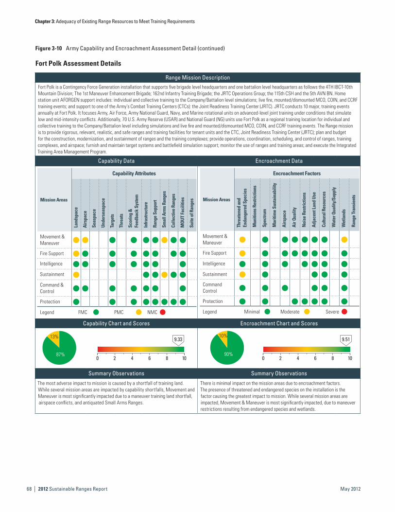
Chapter 3: Adequacy of Existing Range Resources to Meet Training Requirements
| 2012 Sustainable Ranges Report68 May 2012
Figure 3-10 Army Capability and Encroachment Assessment Detail (continued)
Fort Polk Assessment Details
Range Mission Description
Fort Polk is a Contingency Force Generation installation that supports five brigade level headquarters and one battalion level headquarters as follows the 4TH IBCT-10th Mountain Division; The 1st Maneuver Enhancement Brigade; 162nd Infantry Training Brigade; the JRTC Operations Group; the 115th CSH and the 5th AVN BN. Home station unit AFORGEN support includes: individual and collective training to the Company/Battalion level simulations; live fire, mounted/dismounted MCO, COIN, and CCRF training events; and support to one of the Army’s Combat Training Centers (CTCs): the Joint Readiness Training Center (JRTC). JRTC conducts 10 major, training events annually at Fort Polk. It focuses Army, Air Force, Army National Guard, Navy, and Marine rotational units on advanced-level joint training under conditions that simulate low and mid-intensity conflicts. Additionally, 70 U.S. Army Reserve (USAR) and National Guard (NG) units use Fort Polk as a regional training location for individual and collective training to the Company/Battalion level including simulations and live fire and mounted/dismounted MCO, COIN, and CCRF training events. The Range mission is to provide rigorous, relevant, realistic, and safe ranges and training facilities for tenant units and the CTC, Joint Readiness Training Center (JRTC); plan and budget for the construction, modernization, and sustainment of ranges and the training complexes; provide operations, coordination, scheduling, and control of ranges, training complexes, and airspace; furnish and maintain target systems and battlefield simulation support; monitor the use of ranges and training areas; and execute the Integrated Training Area Management Program.
Capability Data Encroachment Data
Mission Areas
Capability Attributes
Land
spac
e
Airs
pace
Seas
pace
Unde
rsea
spac
e
Targ
ets
Thre
ats
Scor
ing
&
Feed
back
Sys
tem
Infra
stru
ctur
e
Rang
e Su
ppor
t
Smal
l Arm
s Ra
nges
Colle
ctiv
e Ra
nges
MOU
T Fa
cilit
ies
Suite
of R
ange
s
Movement & Maneuver
4 4 4 4 4 4 4 4 4
Fire Support 4 4 4 4 4 4 4 4
Intelligence 4 4 4 4 4 4 4
Sustainment 4 4 4 4 4 4
Command & Control
4 4 4 4 4 4 4
Protection 4 4 4 4 4 4 4 4
Legend FMC PMC NMC
Mission Areas
Encroachment Factors
Thre
aten
ed a
nd
Enda
nger
ed S
peci
es
Mun
ition
s Res
trict
ions
Spec
trum
Mar
itim
e Su
stai
nabi
lity
Airs
pace
Air Q
ualit
y
Noi
se R
estri
ctio
ns
Adja
cent
Lan
d Us
e
Cultu
ral R
esou
rces
Wat
er Q
ualit
y/Su
pply
Wet
land
s
Rang
e Tr
ansi
ents
Movement & Maneuver
4 4 4 4 4 4 4 4
Fire Support 4 4 4 4 4 4 4 4
Intelligence 4 4 4 4 4 4 4
Sustainment 4 4 4 4 4
Command Control
4 4 4 4 4 4
Protection 4 4 4 4 4 4 4
Legend Minimal Moderate Severe
Capability Chart and Scores Encroachment Chart and Scores
13%
87%
9.33
0 2 4 6 8 10
10%
90%
9.51
0 2 4 6 8 10
Summary Observations Summary Observations
The most adverse impact to mission is caused by a shortfall of training land. While several mission areas are impacted by capability shortfalls, Movement and Maneuver is most significantly impacted due to a maneuver training land shortfall, airspace conflicts, and antiquated Small Arms Ranges.
There is minimal impact on the mission areas due to encroachment factors. The presence of threatened and endangered species on the installation is the factor causing the greatest impact to mission. While several mission areas are impacted, Movement & Maneuver is most significantly impacted, due to maneuver restrictions resulting from endangered species and wetlands.

Chapter 3: Adequacy of Existing Range Resources to Meet Training Requirements
2012 Sustainable Ranges Report | 69May 2012
Fort Polk Assessment Details
Historical Information, Results, and Future Projections Historical Information, Results, and Future ProjectionsCalendar Year 2008 2009 2010 2011 Calendar Year 2008 2009 2010 2011
Capability Scores 8.73 8.73 7.94 9.33 Encroachment Scores 10.00 10.00 9.51 9.51
Capabilities have improved at Fort Polk since 2010. Range Support funding increased in FY2011; however, recent manpower reductions will cause a 20% cut in range operations starting in FY2012. A shortage of modernized Small Arms Ranges has continued to impact capability at Fort Polk; however, new range requirements have been documented and, if funding is available, capability should improve in the outyears. Landspace continues to impact maneuver capability, but the purchase of additional training land will significantly improve this capability in the outyears. Airspace capability will likely become a greater challenge into the outyears, as requirements to field new UAS systems increase.
Encroachment factors have not historically had a significant impact on the mission at Fort Polk. Minor to moderate impacts resulting from threatened and endangered species, the presence of feral horses, and wetlands have developed over the last two years, and are anticipated to result in continued impacts to maneuver training and live fire exercises in the outyears. The installation is actively pursuing buffer initiatives through the Army Compatible Use Buffer (ACUB) Program to reduce existing impacts and prevent future impacts. Additionally, training land acquisition efforts should help to alleviate maneuver training impacts by providing additional maneuver land to meet training requirements.
Fort Polk Detailed CommentsCapability Observations
Attributes Assigned Training Mission Score Comments
Landspace
Movement & Maneuver
h
The installation has a maneuver training land shortfall per AR 350-19. The training land shortfall of 100,000 acres limits the ability of the installation to simultaneously train a Brigade Combat Team and a rotation at the JRTC. Additionally, the installation cannot fully accommodate range live fire and maneuver training at the same time. Final approval for training land acquisition was granted by OSD in April 2010. Funding for land acquisition was appropriated in FY2010–FY2011, and additional funding is programmed in FY2012. Funds programmed in FY2013 were cut due to funding shortfalls. Negotiations for the purchase of the first parcel of land are ongoing.
Fire Support h Same as above.Sustainment h Same as above.
AirspaceMovement & Maneuver
h
Launching and recovering UAS interrupts active ranges due to proximity of airfield and a small arms range complex. UAS make it difficult to schedule other aircraft within the training area and operate small arms ranges and UAS training simultaneously. The installation is mitigating this issue through the use of more vertical/lateral separation, scheduling additional delays in other aircraft entering the restricted area, and mitigating small arms range impacts through scheduling.
Small Arms Range
Movement & Maneuver
h
Many small arms ranges are WWII and/or Vietnam era, and are not in compliance with current Army regulations (TC 25-8). Fort Polk cannot conduct small arms training to the Army standard and must use non-standard ranges to meet requirements (TC 25-8). Fort Polk has identified outyear requirements for a Multi-Purpose Machine Gun (MPMG) Range, Infantry Platoon Battle Course, and Infantry Squad Battle Course.
Sustainment h Same as above.
Encroachment Observations
Factors Assigned Training Mission Score Comments
Threatened & Endangered Species
Movement & Maneuver
h
The Red-Cockaded Woodpecker and Louisiana Pine Snake are protected species that are present on the installation. Endangered species habitat restricts, prohibits, and limits maneuver training on the installation.The Army implements ongoing mitigation to avoid training impacts. The ACUB Program is an integral component of the Army’s sustainability triple bottom-line: mission, environment, and community. In recent years, Army installations have experienced increasing encroachment because of population growth, change in, or expansion of existing land use, and environmental requirements. The ACUB Program proactively addresses encroachment, while achieving conservation objectives through the purchase of conservation easements. Fort Polk’s ACUB Program is attempting to secure easements in Bienville Parish.
Fire Support h Same as above.Sustainment h Same as above.
WetlandsMovement & Maneuver
hThere are 16,538 acres of wetlands on the installation, which includes U.S. Forest Service (USFS) permitted land. Training is restricted in wetland areas, thus reducing the availability of maneuver training land necessary to fully meet requirements. Fort Polk continues to construct low water crossings as funding becomes available.
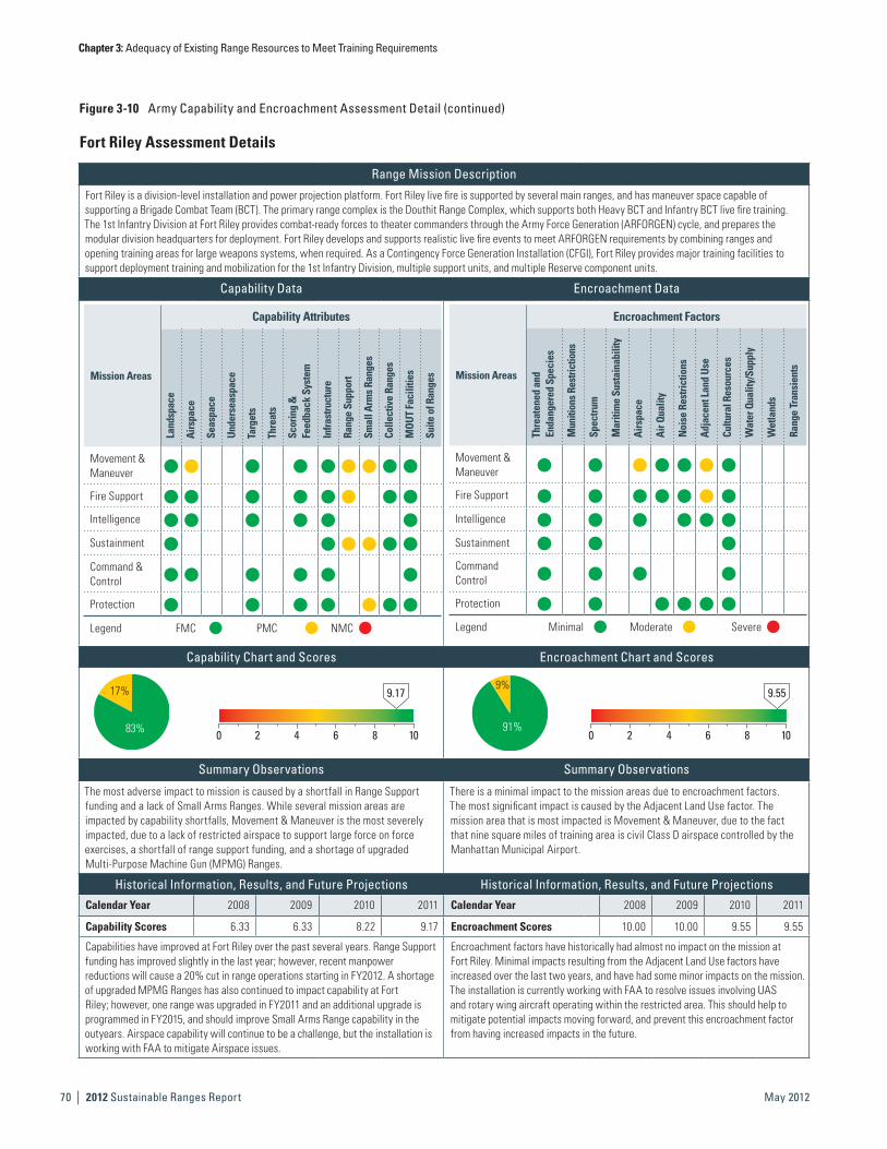
Chapter 3: Adequacy of Existing Range Resources to Meet Training Requirements
| 2012 Sustainable Ranges Report70 May 2012
Figure 3-10 Army Capability and Encroachment Assessment Detail (continued)
Fort Riley Assessment Details
Range Mission Description
Fort Riley is a division-level installation and power projection platform. Fort Riley live fire is supported by several main ranges, and has maneuver space capable of supporting a Brigade Combat Team (BCT). The primary range complex is the Douthit Range Complex, which supports both Heavy BCT and Infantry BCT live fire training. The 1st Infantry Division at Fort Riley provides combat-ready forces to theater commanders through the Army Force Generation (ARFORGEN) cycle, and prepares the modular division headquarters for deployment. Fort Riley develops and supports realistic live fire events to meet ARFORGEN requirements by combining ranges and opening training areas for large weapons systems, when required. As a Contingency Force Generation Installation (CFGI), Fort Riley provides major training facilities to support deployment training and mobilization for the 1st Infantry Division, multiple support units, and multiple Reserve component units.
Capability Data Encroachment Data
Mission Areas
Capability Attributes
Land
spac
e
Airs
pace
Seas
pace
Unde
rsea
spac
e
Targ
ets
Thre
ats
Scor
ing
&
Feed
back
Sys
tem
Infra
stru
ctur
e
Rang
e Su
ppor
t
Smal
l Arm
s Ra
nges
Colle
ctiv
e Ra
nges
MOU
T Fa
cilit
ies
Suite
of R
ange
s
Movement & Maneuver
h h h h h h h h h
Fire Support h h h h h h h h
Intelligence h h h h h h
Sustainment h h h h h h
Command & Control
h h h h h h
Protection h h h h h h h
Legend FMC PMC NMC
Mission Areas
Encroachment Factors
Thre
aten
ed a
nd
Enda
nger
ed S
peci
es
Mun
ition
s Res
trict
ions
Spec
trum
Mar
itim
e Su
stai
nabi
lity
Airs
pace
Air Q
ualit
y
Noi
se R
estri
ctio
ns
Adja
cent
Lan
d Us
e
Cultu
ral R
esou
rces
Wat
er Q
ualit
y/Su
pply
Wet
land
s
Rang
e Tr
ansi
ents
Movement & Maneuver
h h h h h h h
Fire Support h h h h h h h
Intelligence h h h h h h
Sustainment h h h
Command Control
h h h h
Protection h h h h h h
Legend Minimal Moderate Severe
Capability Chart and Scores Encroachment Chart and Scores
17%
83%
9.17
0 2 4 6 8 10
9%
91%
9.55
0 2 4 6 8 10
Summary Observations Summary Observations
The most adverse impact to mission is caused by a shortfall in Range Support funding and a lack of Small Arms Ranges. While several mission areas are impacted by capability shortfalls, Movement & Maneuver is the most severely impacted, due to a lack of restricted airspace to support large force on force exercises, a shortfall of range support funding, and a shortage of upgraded Multi-Purpose Machine Gun (MPMG) Ranges.
There is a minimal impact to the mission areas due to encroachment factors. The most significant impact is caused by the Adjacent Land Use factor. The mission area that is most impacted is Movement & Maneuver, due to the fact that nine square miles of training area is civil Class D airspace controlled by the Manhattan Municipal Airport.
Historical Information, Results, and Future Projections Historical Information, Results, and Future ProjectionsCalendar Year 2008 2009 2010 2011 Calendar Year 2008 2009 2010 2011
Capability Scores 6.33 6.33 8.22 9.17 Encroachment Scores 10.00 10.00 9.55 9.55
Capabilities have improved at Fort Riley over the past several years. Range Support funding has improved slightly in the last year; however, recent manpower reductions will cause a 20% cut in range operations starting in FY2012. A shortage of upgraded MPMG Ranges has also continued to impact capability at Fort Riley; however, one range was upgraded in FY2011 and an additional upgrade is programmed in FY2015, and should improve Small Arms Range capability in the outyears. Airspace capability will continue to be a challenge, but the installation is working with FAA to mitigate Airspace issues.
Encroachment factors have historically had almost no impact on the mission at Fort Riley. Minimal impacts resulting from the Adjacent Land Use factors have increased over the last two years, and have had some minor impacts on the mission. The installation is currently working with FAA to resolve issues involving UAS and rotary wing aircraft operating within the restricted area. This should help to mitigate potential impacts moving forward, and prevent this encroachment factor from having increased impacts in the future.

Chapter 3: Adequacy of Existing Range Resources to Meet Training Requirements
2012 Sustainable Ranges Report | 71May 2012
Fort Riley Detailed CommentsCapability Observations
Attributes Assigned Training Mission Score Comments
AirspaceMovement & Maneuver
h
Approximately nine square miles of training area is civil Class D airspace controlled by the Manhattan Municipal Airport. The installation lacks the horizontal airspace necessary to support the conduct of large force on force exercises. There are several actions currently under way to reduce the shortfall. The installation is reworking the SOP with FAA to operate more effectively with the two airfields located to the south of Fort Riley that affect a three-mile restricted area. Another step that has supported training is to conduct more air and ground training at Smoky Hill Army Airfield in Salina KS.
Range Support
Movement & Maneuver
h
Recent manpower reductions will cause a 20% cut in range operations starting in FY2012. This will limit installation support for short-term training requests; range reconfiguration projects to support emerging tactics, techniques, and procedures; and preventative maintenance. The installation is working to increase staff to meet ARFORGEN requirements and realigning for greater efficiency.
Fire Support h Same as above.Sustainment h Same as above.
Small Arms Range
Movement & Maneuver
h The installation’s training capabilities are impacted by the shortfall of an upgraded MPMG Range. One MPMG was upgraded in 2011, and a second MPMG has been programmed for construction in 2015.
Sustainment h Same as above.Protection h Same as above.
Encroachment Observations
Factors Assigned Training Mission Score Comments
AirspaceMovement & Maneuver
Approximately nine square miles of training area is civil Class D airspace controlled by the Manhattan Municipal Airport. The installation lacks the horizontal airspace necessary to support the conduct of large force on force exercises. The installation is currently working with FAA to resolve issues involving UAS and rotary wing aircraft operating within the restricted area. COA 1: Create an acceptable waiver exclusion area within off-limits area. COA2: Shut down military and Civilian airport during mandatory training periods. COA3: Continue operations using existing MOA agreement.
Adjacent Land Use
Movement & Maneuver
Approximately nine square miles of training area is civil Class D airspace controlled by the Manhattan Municipal Airport. Artillery and other live fire events are not allowed in Training Areas 25, 26, 27, 28, and 30 (4,106 acres), which comprise a Controlled Firing Area (CFA) and a Special Use Airspace zone. Firing in the CFA would shut down the airport. The installation is currently working with FAA to resolve issues involving UAS and rotary wing aircraft operating within the restricted area Courses of Action (COA) are as follows: COA1: Create a acceptable waiver exclusion area within off-limits area. COA2: Shut down the military and civilian airports during mandatory training periods. COA3: Continue operations using the existing MOA agreement.
Fire Support Same as above.

Chapter 3: Adequacy of Existing Range Resources to Meet Training Requirements
| 2012 Sustainable Ranges Report72 May 2012
Figure 3-10 Army Capability and Encroachment Assessment Detail (continued)
Fort Stewart Assessment Details
Range Mission Description
Fort Stewart and Hunter Army Airfield are the Army’s training and military armored power projection combination on the Eastern Seaboard of the United States. This platform allows military units in the region to deploy rapidly throughout the world. The installation operates and maintains 242,000 acres available for live fire and maneuver training, and ensures Fort Stewart remains a premier force projection platform. Military readiness, training land stewardship, and environmental compliance are a priority for Fort Stewart’s range operations. Live fire ranges are capable of supporting small arms, field artillery, aerial, and tank gunnery. Maneuver training adheres to the tenants of the Army Campaign Plan for Sustainability.
Major units that train at Fort Stewart are the 3rd Infantry Division, the 92nd Engineer Battalion, the 38th Explosive Ordnance Detachment, and the 385th Military Police Battalion. Other tenant units and organizations that train on Fort Stewart are the Non Commissioned Officer (NCO) Academy/Warrior Leader Course, 188th Infantry Brigade, 1st Battalion-75th Ranger Regiment, 3rd Battalion-160th Special Operations Aviation Regiment, 95th Maintenance, Aviation and Missile Command (AMCOM) Project OLR (East), Special Forces Recruiting Team, and multiple Air Force, Coast Guard, and Reserve component units.
Capability Data Encroachment Data
Mission Areas
Capability Attributes
Land
spac
e
Airs
pace
Seas
pace
Unde
rsea
spac
e
Targ
ets
Thre
ats
Scor
ing
&
Feed
back
Sys
tem
Infra
stru
ctur
e
Rang
e Su
ppor
t
Smal
l Arm
s Ra
nges
Colle
ctiv
e Ra
nges
MOU
T Fa
cilit
ies
Suite
of R
ange
s
Movement & Maneuver
4 4 4 4 4 4 4 4 4
Fire Support 4 4 4 4 4 4 4 4
Intelligence 4 4 4 4 4 4
Sustainment 4 4 4 4 4 4
Command & Control
4 4 4 4 4 4
Protection 4 4 4 4 4 4 4
Legend FMC PMC NMC
Mission Areas
Encroachment Factors
Thre
aten
ed a
nd
Enda
nger
ed S
peci
es
Mun
ition
s Res
trict
ions
Spec
trum
Mar
itim
e Su
stai
nabi
lity
Airs
pace
Air Q
ualit
y
Noi
se R
estri
ctio
ns
Adja
cent
Lan
d Us
e
Cultu
ral R
esou
rces
Wat
er Q
ualit
y/Su
pply
Wet
land
s
Rang
e Tr
ansi
ents
Movement & Maneuver
4 4 4 4 4 4 4 4
Fire Support 4 4 4 4 4 4 4 4
Intelligence 4 4 4 4 4 4 4
Sustainment 4 4 4 4 4 4 4 4
Command Control
4 4 4 4 4 4 4
Protection 4 4 4 4 4 4 4 4
Legend Minimal Moderate Severe
Capability Chart and Scores Encroachment Chart and Scores
12%
88%
9.40
0 2 4 6 8 10
46% 54%
7.72
0 2 4 6 8 10
Summary Observations Summary Observations
The greatest impact to mission is caused by a shortfall in small arms and collective ranges. While several mission areas are impacted by capability shortfalls, Movement & Maneuver is the most adversely impacted, due to a maneuver training land shortfall, a shortage of range support funding, and a critical shortfall of upgraded Multi-Purpose Machine Gun (MPMG) Ranges and Collective Ranges to support squad and platoon level training.
There is moderate impact to the mission areas due to encroachment factors. The most significant impacts are caused by Threatened and Endangered Species, Spectrum, Airspace, and Wetlands factors. The mission areas that are most impacted are Movement & Maneuver and Fire Support, due to the presence of endangered species, spectrum competition, airspace encroachment, and wetlands. 100% of field training exercises currently require minor workarounds and a majority of training areas have vegetation concerns, due to tree density and understory. Fort Stewart employs an active timber harvest and controlled burn program to address this issue. While training tasks are accomplished in conjunction with restrictions that result from encroachment factors, costs are incurred as a result of mitigating these encroachment factors.
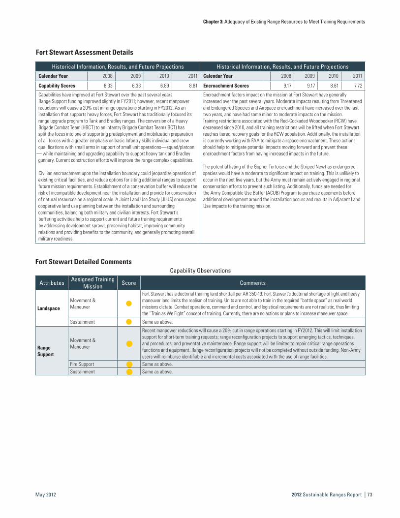
Chapter 3: Adequacy of Existing Range Resources to Meet Training Requirements
2012 Sustainable Ranges Report | 73May 2012
Fort Stewart Detailed CommentsCapability Observations
Attributes Assigned Training Mission Score Comments
Landspace
Movement & Maneuver
Fort Stewart has a doctrinal training land shortfall per AR 350-19. Fort Stewart’s doctrinal shortage of light and heavy maneuver land limits the realism of training. Units are not able to train in the required “battle space” as real world missions dictate. Combat operations, command and control, and logistical requirements are not realistic, thus limiting the “Train as We Fight” concept of training. Currently, there are no actions or plans to increase maneuver space.
Sustainment Same as above.
Range Support
Movement & Maneuver
h
Recent manpower reductions will cause a 20% cut in range operations starting in FY2012. This will limit installation support for short-term training requests; range reconfiguration projects to support emerging tactics, techniques, and procedures; and preventative maintenance. Range support will be limited to repair critical range operations functions and equipment. Range reconfiguration projects will not be completed without outside funding. Non-Army users will reimburse identifiable and incremental costs associated with the use of range facilities.
Fire Support h Same as above.Sustainment h Same as above.
Fort Stewart Assessment Details
Historical Information, Results, and Future Projections Historical Information, Results, and Future ProjectionsCalendar Year 2008 2009 2010 2011 Calendar Year 2008 2009 2010 2011
Capability Scores 6.33 6.33 6.89 8.81 Encroachment Scores 9.17 9.17 8.61 7.72
Capabilities have improved at Fort Stewart over the past several years. Range Support funding improved slightly in FY2011; however, recent manpower reductions will cause a 20% cut in range operations starting in FY2012. As an installation that supports heavy forces, Fort Stewart has traditionally focused its range upgrade program to Tank and Bradley ranges. The conversion of a Heavy Brigade Combat Team (HBCT) to an Infantry Brigade Combat Team (IBCT) has split the focus into one of supporting predeployment and mobilization preparation of all forces with a greater emphasis on basic Infantry skills individual and crew qualifications with small arms in support of small unit operations—squad/platoon
— while maintaining and upgrading capability to support heavy tank and Bradley gunnery. Current construction efforts will improve the range complex capabilities.
Civilian encroachment upon the installation boundary could jeopardize operation of existing critical facilities, and reduce options for siting additional ranges to support future mission requirements. Establishment of a conservation buffer will reduce the risk of incompatible development near the installation and provide for conservation of natural resources on a regional scale. A Joint Land Use Study (JLUS) encourages cooperative land use planning between the installation and surrounding communities, balancing both military and civilian interests. Fort Stewart’s buffering activities help to support current and future training requirements by addressing development sprawl, preserving habitat, improving community relations and providing benefits to the community, and generally promoting overall military readiness.
Encroachment factors impact on the mission at Fort Stewart have generally increased over the past several years. Moderate impacts resulting from Threatened and Endangered Species and Airspace encroachment have increased over the last two years, and have had some minor to moderate impacts on the mission. Training restrictions associated with the Red-Cockaded Woodpecker (RCW) have decreased since 2010, and all training restrictions will be lifted when Fort Stewart reaches tiered recovery goals for the RCW population. Additionally, the installation is currently working with FAA to mitigate airspace encroachment. These actions should help to mitigate potential impacts moving forward and prevent these encroachment factors from having increased impacts in the future.
The potential listing of the Gopher Tortoise and the Striped Newt as endangered species would have a moderate to significant impact on training. This is unlikely to occur in the next five years, but the Army must remain actively engaged in regional conservation efforts to prevent such listing. Additionally, funds are needed for the Army Compatible Use Buffer (ACUB) Program to purchase easements before additional development around the installation occurs and results in Adjacent Land Use impacts to the training mission.

Chapter 3: Adequacy of Existing Range Resources to Meet Training Requirements
| 2012 Sustainable Ranges Report74 May 2012
Figure 3-10 Army Capability and Encroachment Assessment Detail (continued)
Encroachment Observations
Factors Assigned Training Mission Score Comments
Threatened & Endangered Species
Movement & Maneuver
h
There are six federally protected species on Fort Stewart. Primary training impacts include movement, maneuver, and live fire restrictions associated with RCW clusters. Additional impacts to training vary depending on species, including limited flyover of marked nests during nesting season (Bald Eagle). Maneuver forces are able to train, with minimal to moderate workarounds dependant on location, even with the restrictions associated with the RCW and other threatened and endangered species. The 2007 Army RCW guidelines have been implemented on Fort Stewart. Training restrictions were removed from 90 RCW clusters in 2010, and an additional 39 clusters will be deprotected by the end of 2011. At the recovery threshold of 350 potential breeding groups, all RCW training restrictions will be removed. An active soldier education program is in place to educate soldiers on restrictions, thus allowing training tasks in conjunction with restrictions associated with protected species. Other training restrictions are related to Frosted Flatwoods Salamanders. Tracked and wheeled vehicles are prohibited from driving through 25 confirmed Frosted Flatwoods Salamander breeding ponds (94 acres). There are no training restrictions associated with the Eastern Indigo Snake, Shortnose Sturgeon, or Wood Stork.
Fire Support h Same as above.Sustainment h Same as above.Protection h Same as above.
Spectrum
Movement & Maneuver
h
Electromagnetic encroachment, due to Objective Force Modernization and increased demand for Government and commercial wireless communications, is of great concern. Spectrum availability also impacts power projection support, first responders, and crisis management activities. Current spectrum challenges include the encroachment of range targetry control systems by radios used by units training in the field, and crowding and overlapping of the RF bands used by Land Mobile Radio, some Unmanned Aerial Vehicle (UAV) control systems and CREW systems. The installation Network Enterprise Center/Director of Information Management is hiring and equipping a full time spectrum manager to mitigate these impacts.
Fire Support h Same as above.Intelligence h Same as above.Sustainment h Same as above.Command & Control h Same as above.Protection h Same as above.
Airspace
Movement & Maneuver
h
New FAA requirements for the Savannah Approach have encroached six nautical miles (nm) inside the installation boundary across the northern boundary of the installation. The affected area is a box approximately 23 KM east/west by 12KM north/south over the northern portion of post. This affects the training of units equipped with UASs. Due to the new requirements, there is NO flight of UASs in the affected area. Fort Stewart is working with FAA to mitigate this loss.
Fire Support h Same as above.Intelligence h Same as above.Sustainment h Same as above.Command & Control h Same as above.Protection h Same as above.
Cultural Resources
Movement & Maneuver
h198 protected sites and cemeteries occupy 829 acres of land. This area is restricted to training, and no ground disturbance or vehicles are allowed within these sites. An active soldier education program is in place to educate soldiers on restrictions, thus allow for accomplishment of training task in conjunction with the restrictions.
Fire Support h Same as above.
Wetlands
Movement & Maneuver
h
Approximately 1/3 of Fort Stewart is wetlands (≈91,000 acres). This poses maneuver and trafficability issues, however, the construction of low water crossings help to mitigate these restrictions. This issue is separate from the issue of wetland and range construction, where wetland credits and mitigation are needed for any construction project. Wetland areas are being purchased to mitigate wetland impact from future range construction projects.
Fire Support h Same as above.Sustainment h Same as above.
Fort Stewart Detailed Comments

Chapter 3: Adequacy of Existing Range Resources to Meet Training Requirements
2012 Sustainable Ranges Report | 75May 2012
This Page is Intentionally Left Blank.
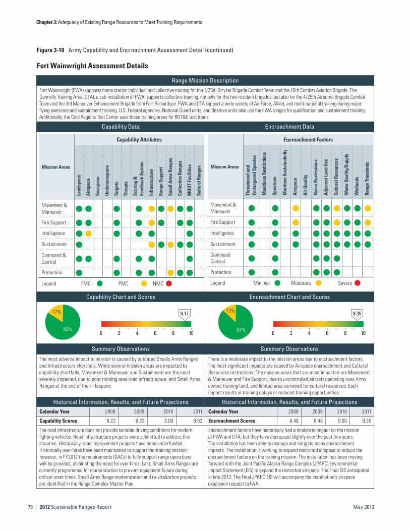
Chapter 3: Adequacy of Existing Range Resources to Meet Training Requirements
| 2012 Sustainable Ranges Report76 May 2012
Figure 3-10 Army Capability and Encroachment Assessment Detail (continued)
Fort Wainwright Assessment Details
Range Mission Description
Fort Wainwright (FWA) supports home station individual and collective training for the 1/25th Stryker Brigade Combat Team and the 16th Combat Aviation Brigade. The Donnelly Training Area (DTA), a sub-installation of FWA, supports collective training, not only for the two resident brigades, but also for the 4/25th Airborne Brigade Combat Team and the 3rd Maneuver Enhancement Brigade from Fort Richardson. FWA and DTA support a wide variety of Air Force, Allied, and multi-national training during major flying exercises and sustainment training. U.S. Federal agencies, National Guard units, and Reserve units also use the FWA ranges for qualification and sustainment training. Additionally, the Cold Regions Test Center uses these training areas for RDT&E test items.
Capability Data Encroachment Data
Mission Areas
Capability Attributes
Land
spac
e
Airs
pace
Seas
pace
Unde
rsea
spac
e
Targ
ets
Thre
ats
Scor
ing
&
Feed
back
Sys
tem
Infra
stru
ctur
e
Rang
e Su
ppor
t
Smal
l Arm
s Ra
nges
Colle
ctiv
e Ra
nges
MOU
T Fa
cilit
ies
Suite
of R
ange
sMovement & Maneuver
4 4 4 4 4 4 4 4 4
Fire Support 4 4 4 4 4 4 4 4
Intelligence 4 4 4 4 4 4
Sustainment 4 4 4 4 4 4
Command & Control
4 4 4 4 4 4
Protection 4 4 4 4 4 4 4
Legend FMC PMC NMC
Mission Areas
Encroachment Factors
Thre
aten
ed a
nd
Enda
nger
ed S
peci
es
Mun
ition
s Res
trict
ions
Spec
trum
Mar
itim
e Su
stai
nabi
lity
Airs
pace
Air Q
ualit
y
Noi
se R
estri
ctio
ns
Adja
cent
Lan
d Us
e
Cultu
ral R
esou
rces
Wat
er Q
ualit
y/Su
pply
Wet
land
s
Rang
e Tr
ansi
ents
Movement & Maneuver
h h h h h h h h h
Fire Support h h h h h h h h h
Intelligence h h h h h h h h h
Sustainment h h h h h h h h h
Command Control
h h h h h
Protection h h h h h
Legend Minimal Moderate Severe
Capability Chart and Scores Encroachment Chart and Scores
17%
83%
9.17
0 2 4 6 8 10
13%
87%
9.35
0 2 4 6 8 10
Summary Observations Summary Observations
The most adverse impact to mission is caused by outdated Smalls Arms Ranges and Infrastructure shortfalls. While several mission areas are impacted by capability shortfalls, Movement & Maneuver and Sustainment are the most severely impacted, due to poor training area road infrastructure, and Small Arms Ranges at the end of their lifespans.
There is a moderate impact to the mission areas due to encroachment factors. The most significant impacts are caused by Airspace encroachment and Cultural Resources restrictions. The mission areas that are most impacted are Movement & Maneuver and Fire Support, due to uncontrolled aircraft operating over Army owned training land, and limited area surveyed for cultural resources. Each impact results in training delays or reduced training opportunities.
Historical Information, Results, and Future Projections Historical Information, Results, and Future ProjectionsCalendar Year 2008 2009 2010 2011 Calendar Year 2008 2009 2010 2011
Capability Scores 8.22 8.22 8.00 8.93 Encroachment Scores 8.46 8.46 9.00 9.35
The road infrastructure does not provide suitable driving conditions for modern fighting vehicles. Road infrastructure projects were submitted to address this situation. Historically, road improvement projects have been underfunded. Historically over-hires have been maintained to support the training mission; however, in FY2012 the requirements (DACs) to fully support range operations will be provided, eliminating the need for over-hires. Last, Small Arms Ranges are currently programmed for modernization to prevent equipment failure during critical reset times. Small Arms Range modernization and re-vitalization projects are identified in the Range Complex Master Plan.
Encroachment factors have historically had a moderate impact on the mission at FWA and DTA, but they have decreased slightly over the past two years. The installation has been able to manage and mitigate many encroachment impacts. The installation is working to expand restricted airspace to reduce the encroachment factors on the training mission. The installation has been moving forward with the Joint Pacific Alaska Range Complex (JPARC) Environmental Impact Statement (EIS) to expand the restricted airspace. The Final EIS anticipated in late 2013. The Final JPARC EIS will accompany the installation’s airspace expansion request to FAA.
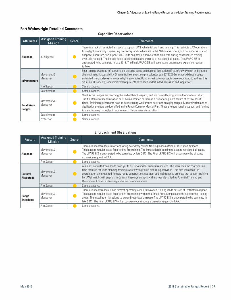
Chapter 3: Adequacy of Existing Range Resources to Meet Training Requirements
2012 Sustainable Ranges Report | 77May 2012
Fort Wainwright Detailed CommentsCapability Observations
Attributes Assigned Training Mission Score Comments
Airspace Intelligence
There is a lack of restricted airspace to support UAS vehicle take-off and landing. This restricts UAS operations to daylight hours only if operating over Army lands, which are in the National Airspace, but not under restricted airspace. Therefore, the support UAS units can provide home station elements during consolidated training events is reduced. The installation is seeking to expand the area of restricted airspace. The JPARC EIS is anticipated to be complete in late 2013. The Final JPARC EIS will accompany an airspace expansion request to FAA.
Infrastructure
Movement & Maneuver
h
Poor training area road infrastructure is an issue based on seasonal fluctuations (freeze/thaw cycles), and creates challenging trail accessibility. Original trail construction (pre-calendar year [CY] 2000) methods did not produce suitable driving surfaces for modern fighting vehicles. Road infrastructure projects were submitted to address this situation. Historically, road improvement projects have been underfunded. This is an enduring effort.
Fire Support h Same as above.Sustainment h Same as above.
Small Arms Ranges
Movement & Maneuver
h
Small Arms Ranges are reaching the end of their lifespans, and are currently programmed for modernization. The timetable for modernization must be maintained or there is a risk of equipment failure at critical reset times. Training requirements have to be met using workaround solutions on aging ranges. Modernization and re-vitalization projects are identified in the Range Complex Master Plan. These projects require support and funding to meet training throughput requirements. This is an enduring effort.
Sustainment h Same as above.Protection h Same as above.
Encroachment Observations
Factors Assigned Training Mission Score Comments
AirspaceMovement & Maneuver
h
There are uncontrolled aircraft operating over Army owned training lands outside of restricted airspace. This leads to regular cease fires for live fire training. The installation is seeking to expand restricted airspace. The JPARC EIS is anticipated to be complete by late 2013. The Final JPARC EIS will accompany the airspace expansion request to FAA.
Fire Support h Same as above.
Cultural Resources
Movement & Maneuver
h
A majority of withdrawn lands have yet to be surveyed for cultural resources. This increases the coordination time required for units planning training events with ground disturbing activities. This also increases the coordination time required for new range construction, upgrade, and maintenance projects that support training. Fort Wainwright will emphasize Cultural Resource surveys within areas classified as Potential Training and Development Zones as funding and other resources allow.
Fire Support h Same as above.
Range Transients
Movement & Maneuver
h
There are uncontrolled civilian aircraft operating over Army owned training lands outside of restricted airspace. This leads to regular cease fires for live fire training within the Small Arms Complex and throughout the training areas. The installation is seeking to expand restricted airspace. The JPARC EIS is anticipated to be complete in late 2013. The Final JPARC EIS will accompany our airspace expansion request to FAA.
Fire Support h Same as above.

Chapter 3: Adequacy of Existing Range Resources to Meet Training Requirements
| 2012 Sustainable Ranges Report78 May 2012
Figure 3-10 Army Capability and Encroachment Assessment Detail (continued)
Yakima Training Center Assessment Details
Range Mission Description
Yakima Training Center (YTC) supports tough, realistic combined arms, joint, and coalition training for U.S. and Allied military units to enhance unit readiness by sustaining training lands, range complexes, and support facilities capable of meeting all present and future training requirements. YTC, along with Joint Base Lewis-McChord (JBLM), has been designated as a Power Generation Platform Complex for the mobilization and post mobilization of Active and Reserve component units. YTC is utilized by Active, Reserve, and National Guard Army units, as well as Marine Corps Reserve units, and allied forces. Most Active Duty units that train at YTC are based at JBLM and are either associated with I Corps or are resident units. These units include the 2nd Infantry Division (3x SBCTs), 42nd Military Police Brigade, 62nd Medical Brigade, 142nd Signal Brigade, 555th Engineer Brigade, 201st BFSB Brigade, 593 Support Battalion, 1st Special Forces Group, 2nd Battalion, 75th Ranger Regiment, 4th Squadron, 6th US Cavalry (Air Cavalry), 64th Engineer Detachment, 4th Battalion, 160th Aviation Regiment, 3rd EOD Battalion, 17th Fires Brigade, 5-5th Air Defense Artillery, 110th CHEM, and multiple Reserve component units.
Capability Data Encroachment Data
Mission Areas
Capability Attributes
Land
spac
e
Airs
pace
Seas
pace
Unde
rsea
spac
e
Targ
ets
Thre
ats
Scor
ing
&
Feed
back
Sys
tem
Infra
stru
ctur
e
Rang
e Su
ppor
t
Smal
l Arm
s Ra
nges
Colle
ctiv
e Ra
nges
MOU
T Fa
cilit
ies
Suite
of R
ange
s
Movement & Maneuver
h h h h h h h h h
Fire Support h h h h h h h h
Intelligence h h h h h h
Sustainment h h h h h h
Command & Control
h h h h h h
Protection h h h h h h h
Legend FMC PMC NMC
Mission Areas
Encroachment Factors
Thre
aten
ed a
nd
Enda
nger
ed S
peci
es
Mun
ition
s Res
trict
ions
Spec
trum
Mar
itim
e Su
stai
nabi
lity
Airs
pace
Air Q
ualit
y
Noi
se R
estri
ctio
ns
Adja
cent
Lan
d Us
e
Cultu
ral R
esou
rces
Wat
er Q
ualit
y/Su
pply
Wet
land
s
Rang
e Tr
ansi
ents
Movement & Maneuver
h h h h h h h h
Fire Support h h h h h h h h
Intelligence h h h h h h h
Sustainment h h h h h
Command Control
h h h h h h
Protection h h h h h h h
Legend Minimal Moderate Severe
Capability Chart and Scores Encroachment Chart and Scores
10%
90%
9.52
0 2 4 6 8 10
17%
83%
9.15
0 2 4 6 8 10
Summary Observations Summary Observations
The most adverse impact to mission is caused by a shortfall in Range Support funding. While several mission areas are impacted by capability shortfalls, Fire Support is the most impacted attribute, due to a severe shortfall of range staff authorizations and lack of replacement targetry for the Artillery Impact Area.
There is minimal to moderate impact to the mission areas due to encroachment factors. The presence of Threatened and Endangered Species on the installation has the greatest impact on the Movement & Maneuver mission, due to training constraints in the Sage-Grouse protection area that result in the loss of acres available for cross country maneuver.
Historical Information, Results, and Future Projections Historical Information, Results, and Future ProjectionsCalendar Year 2008 2009 2010 2011 Calendar Year 2008 2009 2010 2011
Capability Scores 6.89 6.89 8.22 9.52 Encroachment Scores 8.90 8.90 9.02 9.15
Capabilities have generally improved at YTC over the past several years. Infrastructure shortfalls have been addressed and resources are programmed in the outyears. While Range Support funding improved slightly in FY2011, recent manpower reductions will cause a 20% cut in range operations starting in FY2012. Airspace capability will likely become a greater challenge into the outyears, as requirements to field new UASs increase.
Encroachment factors have historically had a minimal to moderate impact on the mission at YTC. Moderate impacts resulting from Threatened and Endangered Species habitat areas and Wetlands have continued to restrict land use for maneuver training. It is anticipated that these impacts will continue into the future. The installation will continue to mitigate impacts to training through training scenario workarounds and scheduling.

Chapter 3: Adequacy of Existing Range Resources to Meet Training Requirements
2012 Sustainable Ranges Report | 79May 2012
Yakima Training Center Detailed CommentsCapability Observations
Attributes Assigned Training Mission Score Comments
Targets Fire SupportExisting armored targetry on the Anti-Armor Range has deteriorated, and there is a shortfall of replacement targetry for the Artillery Impact Area. Field Artillery units are unable to shoot at appropriate targetry. The installation is seeking procurement of funds to acquire additional targetry to enhance indirect fire training.
Range Support
Movement & Maneuver
hRecent manpower reductions will cause a 20% cut in range operations starting in FY2012. This will limit installation support for short-term training requests; range reconfiguration projects to support emerging tactics, techniques, and procedures; and preventative maintenance.
Fire Support h Same as above.Sustainment h Same as above.
Encroachment Observations
Factors Assigned Training Mission Score Comments
Threatened & Endangered Species
Movement & Maneuver
hThe Sage-Grouse protection area restricts use of 13% of the installation. Within the Sage-Grouse protection area, training is constrained, thus resulting in loss of acres available for cross country maneuver. The Army is continuing to implement mitigation strategies and workarounds to avoid training shortfalls.
Fire Support h Same as above.Sustainment h Same as above.Protection h Same as above.
AirspaceMovement & Maneuver
h Airspace along Interstate 90 is reserved for General Aviation (GA) aircraft to fly. No live fire is permitted within 2000 meters of Interstate 90. The Army is continuing to mitigate this restriction through the use of training workarounds.
Fire Support h Same as above.
WetlandsMovement & Maneuver
hThere is a 100m buffer area around streams and springs, restricted to all digging and maneuver activities.This restricts the area where digging and maneuver can occur, thus reducing the available maneuver land. The Army is continuing implement mitigation strategies and workarounds to avoid training shortfalls.

| 2012 Sustainable Ranges Report80 May 2012
Chapter 3: Adequacy of Existing Range Resources to Meet Training Requirements
Table 3-3 Army Range Capability and Encroachment Assessment Comparison
Range Name Capability Score Encroachment Score
Fort Benning
9.39
0 2 4 6 8 10
8.81
0 2 4 6 8 10
Fort Bliss
9.40
0 2 4 6 8 10
9.63
0 2 4 6 8 10
Fort Bragg
9.07
0 2 4 6 8 10
9.39
0 2 4 6 8 10
Fort Campbell
9.05
0 2 4 6 8 10
9.88
0 2 4 6 8 10
Fort Carson
9.52
0 2 4 6 8 10
9.71
0 2 4 6 8 10
Fort Drum
9.19
0 2 4 6 8 10
10.00
0 2 4 6 8 10
USAG Hawaii
9.15
0 2 4 6 8 10
8.78
0 2 4 6 8 10
Fort Hood
9.22
0 2 4 6 8 10
9.52
0 2 4 6 8 10
Fort Irwin
8.70
0 2 4 6 8 10
8.61
0 2 4 6 8 10
Fort Lewis
8.33
0 2 4 6 8 10
8.57
0 2 4 6 8 10
Fort Polk
9.33
0 2 4 6 8 10
9.51
0 2 4 6 8 10
Fort Riley
9.17
0 2 4 6 8 10
9.55
0 2 4 6 8 10

Chapter 3: Adequacy of Existing Range Resources to Meet Training Requirements
2012 Sustainable Ranges Report | 81May 2012
Range Name Capability Score Encroachment Score
Fort Stewart
9.40
0 2 4 6 8 10
7.72
0 2 4 6 8 10
Fort Wainwright
9.17
0 2 4 6 8 10
9.35
0 2 4 6 8 10
Yakima Training Center
9.52
0 2 4 6 8 10
9.15
0 2 4 6 8 10
Table 3-3 Army Range Capability and Encroachment Assessment Comparison (continued)

Chapter 3: Adequacy of Existing Range Resources to Meet Training Requirements
| 2012 Sustainable Ranges Report82 May 2012
Table 3-4 Army Range Mission Description
Fort BenningFort Benning and the MCoE provide trained and adaptive soldiers and Leaders for an Army at War, while developing future requirements for the individual soldier and the Maneuver Force and providing a world class quality of life for our soldiers and Army families. The MCoE Command priorities are to: (1) Fully Support an Army at War; (2) Prepare for the Future; (3) Enhance Quality of Life for soldiers and Army Families; (4) Operate in a Command Climate of Teamwork, Discipline and Standards and Safety; (5) Fully Transition to the MCoE; and (6) Demonstrate Inspired Leadership. Implied in this is the responsibility to provide the Training and Doctrine Command (TRADOC) with a full spectrum of support in doctrine, training, capability development, and training support products for the Maneuver Force. The MCoE’s function is to serve as the user representative in the development of training methodologies and products, concepts, doctrine, organizational requirements, and materiel capability requirements for each functional area, as well as to provide instructors to teach classes across the MCoE. Currently, Fort Benning provides the home station and training facilities for FORSCOM’s 3-3rd HBCT, 11th Engineer Battalion, 13th Corps Support and Sustainment Battalion, and 14th Combat Support Hospital; Special Operations Command’s (SOCOM) 75th Ranger Regiment, and its 3rd Battalion, 75th Ranger Regiment, and Special Troops Battalion; MEDCOM activities; DENTCOM activities; and numerous other active duty deployable units. Also, Fort Benning provides the home station and training facilities for the Western Hemisphere Institute for Security Cooperation (WHINSEC), which has the mission to train cadets, NCOs, and officers from over 25 Western Hemisphere countries. Fort Benning is the sixth largest installation in the United States with the third largest troop density. More than 120,000 Service members, family members, retirees, civilian employees and contractors work, live, and use services on Fort Benning. As Fort Benning transitions to the MCoE, there will be more than 11,000 new jobs on the installation for soldiers, civilians, and contractors. More than $3.5 billion in construction will be invested on Fort Benning through 2016. The rapid growth of soldiers, families, and civilians that Fort Benning will have to provide services for will grow faster than the means to support all of their needs. Currently, Fort Benning conducts 61 courses; with the MCoE transformation, it will bring 39 new courses, impacting contracted labor and services, over 200 new facilities, and 5 new maneuver training areas.
USAG Hawaii The mission of the U.S. Army Pacific (USARPAC) is to execute continuous training and readiness oversight responsibilities for Army Force Generation in Hawaii. On order, USARPAC executes Joint Force Land Component Command functions in support of Homeland Defense and Security in Hawaii. The mission of USAG-HI is to: (1) Plan and execute on-order deployment support, force protections, and contingency operations; (2) Plan and execute transformation of the installation garrison that supports Stryker and other mission units; (3) Provide quality installation support and services to our customers; (4) Maintain and improve infrastructure and training areas; (5) Provide proper stewardship of all resources and the environment; (6) Sustain strong community relations; and (7) Provide for the well-being of the Army Family into the 21st Century.
USAG-HI comprises two primary installations, Schofield Barracks and Pohakuloa Training Area (PTA), and five primary training annexes. USARPAC provides multiple live fire training venues. Its Basic Weapons Marksmanship Ranges used to qualify or train on small arms weapons. Future Direct Fire Gunnery Ranges are used to qualify and train Stryker crews on Tables I-VIII. USARPAC Collective Live Fire Ranges are used for collective training events, such as infantry squad and platoon battle courses (ISBCs and IPBCs), Urban Assault Courses (UAC) and Aerial Gunnery Ranges (AGRs) used to qualify on Tables IX-XII. Indirect Fire Ranges or dedicated firing points are used for the qualification and training of mortars, field artillery, or air defense artillery and OPs. Special Live Fire Ranges and training areas are used for qualification and training of demolitions, live hand grenades, and claymores, and as test and evaluation ranges and facilities. USARPAC maneuver training land is used to conduct force-on-force maneuver training and Situational Training Exercises (STXs). Areas are classified as light or heavy, depending on the type of training they can support.
Based on the geographic location of Hawaii and force structures, the Armed Forces are poised at the center of the Pacific for rapid deployment to any worldwide location, and the ranges and training areas are used by the Joint Forces.
Units that train and deploy from USARPAC are: 2nd SBCT, 3rd IBCT, 25th CAB, 25th STB, 25th ID HQ’s and Div Base Elements, 8th TSC, 500th MI Group, 516th SIG BDE, 8th MP BDE, 45th Sustainment BDE, 130th ENG BDE, 10th SG, 8th STB, HIARNG, GUARNG, 9th RSC, and the USMC.