35 virtual geomagnetic pole positions for north …
TRANSCRIPT
Arizona Geological Society Digest, Volume VII, November 1964
VIRTUAL GEOMAGNETIC POLE POSITIONS FOR NORTH AMERICA AND THEIR SUGGESTED PALEOLATITUDES
By
R. L. DuBois
Department of Geology, University of Arizona, Tucson, Arizona
ABSTRACT
35
A virtual geomagnetic polar wandering curve obtained from paleomagnetic results from North America places the North Pole in the central United States in Precambrian time. The curve shows polar movement from there to a mid-Pacific position near the equator during late Precambrian time and then northward to Japan and Siberia during Paleozoic time and finally to its present position during Mesozoic and Tertiary time. Using virtual geomagnetic poles as a guide, paleolatitudes are constructed for various periods of geological time. The central North American continent occupies a near-equatorial position for most of Paleozoic time. It was in high latitudes during Precambrian time and similar latitudes to present ones since mid-Tertiary.
INTRODUC TION
It is the purpose of this paper to describe the location of virtual geomagnetic poles as determined from paleomagnetic observations on rocks of various geological ages in North America . The results are presented as a curve that depicts a path of relative movement of the geomagnetic pole or continental mass with regard to time. It is impossible, with data from a single continent, to relate the relative movement to either individual polar shift or continental drift or to a combination of the two. If the pole is selected as a reference, the movement is continental ; whereas, if the continent is chosen as a reference, the movement is polar. Axelrod (1963 ) has concluded that paleobotanical data opposes continental drift, but this evidence is essentially in concord with the polar wandering data of this paper . Paleomagnetic poles are used to suggest positions of paleolatitudes for North America. Paleolatitudes are determined for most geological ages and provide a useful presentation of this type of information for other interested investigators besides the paleomagnetist.
The present magnetic field of the earth approximates that of a slightly displaced dipole with an axis inclined 1 10 to the rotational axis. The intersection of the axis of this dipole with the earth's surface defines the geomagnetic pole, which differs from the magnetic pole, or the location of the point at which the inclination of the magnetic field is 900• Paleomagnetic measurements made on volcanic rocks from Hawaii, formed during the 1800' s and 1900' s, when averaged give results similar to the present position of the geomagnetic

36
pole and amply attest to paleomagnetic methods . These methods, when applied to rocks of Recent age, give virtual geomagnetic poles that group around the present geographic pole (point defined by the rotational axis of the earth) . These results and some theoretical considerations from theories on the origin of the geomagnetic fields suggest that the geographic and geomagnetic poles coincide when averaged over much of geologic time. If we consider the main magnetic field of the earth to oe produced by a self-excited dynamo (Elasasser, 1956), then a motion of a rotating electrically conducting fluid is required by the theory to produce a magnetic field. As the rotation is supplied by the earth' s rotation, the generated magnetic field would have an orientation symmetrical about the axis of rotation (Runcorn, 1954 ; Cox and Doell, 1960). The position of the geomagnetic poles, as determined from paleomagnetic observations, is little changed in the last 20 million years, or since about early middle Miocene, but during early Tertiary and Mesozoic its position was Significantly different: The pOSitions of the geomagnetic pole, with regard to time, suggest a polar wandering curve and paleolatitudes of the individual locations .
The data used for the construction of the polar curve have been taken extensively from the paper by Cox and Doell (1960). Additional values are from recent papers by Hood (1961), DuBois (1 962), Currie and others (1963) , and Black (1963) and from unpublished data obtained in this laboratory. The tabulation of this data would considerably extend this paper and change the emphasis. It is available to anyone who is interested, and the results will be presented in a future paper along with other paleomagnetic measurements currently being made.
To determine the position of lines of equal paleolatitude, average paleogeomagnetic poles were obtained from the polar wandering curve for most of the geological periods . These poles were used to position a wire latitude net on a globe, locating the latitudes relative to a particular geomagnetic pole. The values are plotted on maps showing the North American continent. This method of showing the results of paleomagnetic investigations allows not only visualization of relative translations of the continents or poles but also rotational movements. The paleolatitudes are extrapolated to other continents with no consideration for continental drift. This usage of data obtained from North American rocks is of course not justified and is only done to present a basis for considering paleontological evidence and to evaluate it in light of continental drift. In contrast to North American results are paleolatitudes based on paleomagnetic evidence from Australia and Africa.
G EOMAGNETIC POLES
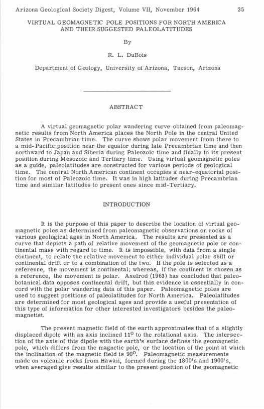
Figure 1 shows, as a curve, the location of paleogeomagnetic poles as determined by paleomagnetic methods for North America. For recent time the position of the paleogeomagnetic pole is the same as that of the geographic pole ; whereas, as late as early Tertiary, the position of the paleogeomagnetic pole is significantly different. A more or less circular path is observed back during the Jurassic, and a more southerly pOSition is noted for Triassic time. Poles during the Permian appear to fit a curve displaced slightly westward, and middle and early Paleozoic poles are located along a curve extending southward. Whereas, the Carboniferous pole is near the north end of this curve, and the curve may have a northerly pOSition in that portion. Polar data for Precambrian time are subject to quite different interpretations by various workers . The majority of the data places the poles in the mid-Pacific area,

Fig
ure
1.
--C
urv
e s
how
ing
lo
cati
on
of
pa
leo
ma
gn
etic
po
les
for
No
rth
Am
er
ica
. w
..
.;J

38
and the curve is shown extending generally eastward and then northward. The deviation of the curve to the north is suggested by the paleogeomagnetic poles of the geochemically dated Duluth Gabbro, 1 , 120 m. y. , Goldich and others ( 1 957), and DuBois ( 1962 ) ; the Sierra Ancha Diabase, 1 , 140 m. y. , Damon and Green (1963 ) ; 1 , 200 m. y. , Silver (1960) ; pole position 280 N. , 1790 W. , unpublished ; and other published paleomagnetic results. The deviation to the southward is supported by measurements of some older rocks (Collinson and Runcorn, 1 960), including some additional measurements by Runcorn (personal communication) or rocks of the Apache Formation.
The relative ages and corresponding pole positions for the rocks suggest a generalized figure of a third of a degree per million years for the rate of relative polar shift, as given by C reer and others ( 1957).
The shape and position of the paleogeomagnetic polar wandering curve are controlled by the ages aSSigned the rocks measured and the accuracy and reliability of the paleomagnetic data . Whereas, there are abounding data published concerning the pOSition of the poles for most geological times ; many of the rocks studied do not give reliable results, or the ages are in question. Urgently needed are paleomagnetic measurements on rocks with more accurate relative age assignments or which are physically dated.
PALEOLA TITUDES
The position of paleolatitudes for North America is given as dotted full lines in figure 2 through figure 12 , with the present latitudes given on each figure for reference. As the paleo geomagnetic pole for the late Tertiary and Recent is similar in position to the present one, the paleolatitudes are also in the same location (fig. 2 ) . Figure 3 , showing the paleolatitudes for C retaceous t ime, suggests a relative counterclockwise rotation for the pole when referenced to the North American continent. The central part of the continent has undergone little change in latitude, but Greenland occupied apprOXimately 150
more southerly latitudes and Alaska nearly 150 more northerly latitudes. By Jurassic tim e (fig. 4), the previous counterclockwise rotation has been essentially counteracted by a clockwise rotation. During this time, North America was in 1 00 more southerly latitides. A counterclockwise rotation and a northward shift occurred in the Triassic (fig. 5). C entral North America then occupied a location at 200 N. latitude. Figure 6 shows the paleolatitudes for Permian time, and the central part of the United States is shown in a position some 100 south of the equator. During the Carboniferous (fig. 7) , the central part of the United States was still equatorial, but the northward s hifting of the pole has almost ceased. The main movements are those of rotation in the Ordovician (fig. 8) and Cambrian (fig. 9) . The equatorial plane during the Cambrian passes nearly north-south trending through the central part of the North American continent.
Three generalized positions are considered for the Precambrian. Figure 10 shows a position 1 , 1 00 - 1 , 200 m illion years ago when c entral North America occupied a latitude position similar to the present. On figure 1 1 the paleolatitudes are those of an older time and are more northerly. By the time represented in figure 12 , the paleogeomagnetic pole has gradually moved northward to a central position.
The correlation between the indicated positions of paleolatitudes and

Figure 2. --Pale 1 t ·
.
o a Itudes of lat .
e Tertiary and R ecent tim e.
39

40
15 _ - - -- - -
-- ..--- -
..- --
Figur e 3 . -- Paleolatitudes of C retaceous time.
D

45
...... 1 5 ........ -
15
Figure 4 .
.......
- - ��
t· e of Jurassic 1m • - - Paleolatitudes
4 1

42
D
45
30
1 5
- - -
- - - ���------���--o
Figure 5. -- Paleolatitudes of Triassic time.

30 0 __ '"
--
43
Figure 6. -- Paleolatitudes of Permian time.

44
60
30
/ �
/ /
/ /
/
/ /
/
Figure 7. -- Paleolatitudes of Carboniferous time .

/ /
1 5 I "- / / � . ,��/
/15 / \ ( / / / / 0/ 1 5
Figure 8 . -- Paleolatitudes of Ordovician tim e.
� )
/ /
1�
45

46
I I I I
{ � ______ � _____ 11551{
Figure 9 . -- Paleolatitud es of C am brian t o Im e.

45
/ / /
Figure 10. - - Paleolatitides of Precambrian tim e.
47

48
15
,-----"'1"11 " '\.
/ J
75 /
'\ \ \
Figure 1 1 . - - Paleolatitudes of Precambrian time.

\75 \
"-
+
' ......... _ - ---
---
-----
- - � j.,brian time.
L__
f Precam Paleolatitudes 0 Figure 12 . --
49

50
various features of paleoclimatology is striking. The paleolatitudes for the Precambrian suggest paleoclimatic conditions in agreement with a proposed Precambrian glaciation in North America. The types of floras and the existence and distribution of coal fields in North America are in agreement with the near-equatorial position of the paleolatitudes for late Paleozoic time. The geographic distribution of Silurian salt deposits and coals near the Great Lakes agrees with the position of the paleoequatorial zone, as does the abundancy of Paleozoic limestones in the C entral Interior . A Permian glaciation in South America is compatible with the suggested angular and special pos ition of the paleolatitudes. The characteristics of symmetry of distribution of floras for C retaceous and Jurassic, as given by Axelrod (1963), are in agreement with the position for paleolatitudes for North America. The north-south symmetry as mentioned by Axelrod for Triassic is well represented in the paleolatitudes, and some floras (C hinle of Arizona) seem to be in agreement with a more southerly position for the paleolatitudes .
CONCLUSIONS
The relative movement of the paleo geomagnetic pole, with regard to the North American continent, has been such as to ascribe an arc southward across Siberia and southeastward across Japan to a mid-Pacific position. The general arc continues northeast to central North America. Paleolatitudes, in their relative location, reflect this movement and show a tendency to a counterclockwise rotation and a northward shifting such that southerly latitudes cross North America. This movement is followed by shifting of northerly latitudes southward and ending with a polar position in the central part of the North American continent.
R EFERENC ES C ITED
Axelrod, D. !. , 1963, Fossil floras suggest stable, not drifting, continents : Jour . Geophys . R esearch, v. 68, p. 3257-3263 .
Black, R . F . , 1 963 , Paleomagnetism of part o f the Purcell systen:. in southwestern Alberta and southeastern British Columbia : Geol. Survey Canada Bull. 84.
Collinson, D. W. , and Runcorn, S. K. , 1 960, Paleomagnetic observations in the United States : New evidence for polar wandering and continental drift: Geol. Soc . America Bull. , v. 71 , p. 915-985.
Cox, A . , and Doell, R . R . , 1 960, Review of paleomagnetism : G eol. Soc. America Bull. , v. 71 , p. 645-768 .
C reer, R. M. , Irving, E . , and Runcorn, S. K. , 1 957, Geophysical interpretation of paleomagnetic direction from Great Britian: Phil. Trans . Roy. Soc. London, A, v. 280, p. 144- 156.
C urrie, R. G . , Gromme, C . S . , and Verhoogen, J . , 1 963 , Remanent magnetization of some Upper Cretaceous granitic plutons in the Sierra Nevada, California : Jour . Geophys . Research, v. 68, p. 2263 -2279.

Damon, P. E . , and Green, W. D. , 1 963 , Investigations of the helium age dating method by stable isotope-dilution technique: Vienna, Radioactive Dating, Inst. Atomic Energy Agency, p. 55-71 .
51
DuBois, P . M. , 1 962, Paleomagnetism and correlation of Keweenawan rocks : Geol. Survey Canada Bull. 7 1 .
Elsasser, W. M. , 1 956, Hydromagnetion II. A review: Am. Jour. Physics, v. 23, p. 85-1 10.
Goldich, S. S. , Bookgaard, H. , and Nier, A. 0. , 1957, Investigations in A/K dating: Am. Geophys. Union Trans . , v. 38, p. 547-551 .
Hood, P. J . , 1 961 , Paleomagnetic study of Me Sudbury basin : Jour . Geophys. Research, v. 66, p. 123 5 - 1241 .
Runcorn, S . K. , 1954, The earth's core: Am. Geophys. Union Trans . , v. 3 5, p. 409-463 .
Silver, L. T. , 1 960, Age determinations on Precambrian diabase differentiates in the Sierra Anchas, Gila County, Arizona (abs . ) : G eol. Soc . America Bull. , v. 71, p. 1 973- 1 974.