3d analyst arcgis - esri · ® 3d analyst ™ australia www ... multiple viewpoints, query a...
TRANSCRIPT
Three-Dimensional Visualization and Analysis
ArcGIS® 3D Analyst™
Australiawww.esriaustralia.com.au
Belgium/Luxembourgwww.esribelux.com
Bulgariawww.esribulgaria.com
Canadawww.esricanada.com
China (Beijing)www.esrichina-bj.cn
China (Hong Kong)www.esrichina-hk.com
Finlandwww.esri-fi nland.com
Francewww.esrifrance.fr
Germany/Switzerlandwww.esri-germany.de
www.esri-suisse.ch
Hungarywww.esrihu.hu
Indiawww.esriindia.com
Indonesia/Malaysia62-21-527-1023603-7874-9930
Italywww.esriitalia.it
Japanwww.esrij.com
Koreawww.esrikr.co.kr
Netherlandswww.esrinl.com
Polandwww.esripolska.com.pl
Portugalwww.esri-portugal.pt
Romaniawww.esriro.ro
Singaporewww.esrisa.com
Spainwww.esri-es.com
Swedenwww.esri-sweden.com
Thailandwww.esrith.com
United Kingdomwww.esriuk.com
Venezuelawww.esriven.com
No. GS-35F-5086H
Printed in USA96830INLD10M7/04dh/tk
Copyright © 2004 ESRI. All rights reserved. ESRI, the ESRI globe logo, ArcGIS, 3D Analyst, ArcGlobe, ArcView, ModelBuilder, ArcEditor, ArcInfo, @esri.com, and www.esri.com are trademarks, registered trademarks, or service marks of ESRI in the United States, the European Community, or certain other jurisdictions. Other companies and products mentioned herein are trademarks or registered trademarks of their respective trademark owners.
Place ESRI business partner or distributor address here.
For more than 30 years ESRI has been helping people manage and analyze geographic information. ESRI offers a framework for implementing GIS technology in any organization with a seamless link from personal GIS on the desktop
to enterprisewide GIS client/server and data management systems. ESRI GIS solutions are fl exible and can be customized to meet the needs of our users. ESRI is a full-service GIS company, ready to help you begin, grow, and build success with GIS.
International Offi ces
ESRI
380 New York Street
Redlands, California
92373-8100, USA
Telephone: 909-793-2853
Fax: 909-793-5953
For more information
on ESRI, call
1-800-447-9778(1-800-GIS-XPRT)
or contact an ESRI reseller near you.
Send e-mail inquiries to
Visit ESRI’s Web page at
www.esri.com
Corporate
Outside the United States,
contact your local ESRI distributor.
For the number of your distributor,
call ESRI at 909-793-2853,
ext. 1235,
or visit our Web site at
www.esri.com/international
Regional Offi ces
ESRI–Minneapolis 651-454-0600ESRI–Olympia
360-754-4727ESRI–Boston 978-777-4543
ESRI–California909-793-2853 ext. 1-1906
ESRI–Denver 303-449-7779
ESRI–San Antonio 210-499-1044
ESRI–Charlotte704-541-9810
ESRI–Washington, D.C.703-506-9515
ESRI–St. Louis 636-949-6620 ESRI–Philadelphia
610-337-8380
ESRI–New York City212-349-3700
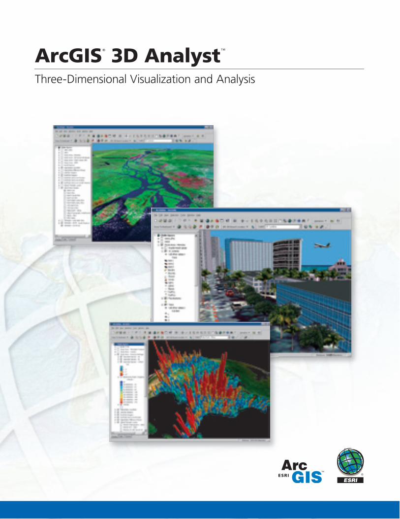
ArcGIS® 3D Analyst
™
Three-Dimensional Visualization and Analysis
ESRI® ArcGIS
® 3D Analyst
™ provides powerful and advanced visualization,
analysis, and surface generation tools. Using ArcGIS 3D Analyst, you can view extremely large sets of data in three-dimensions from multiple viewpoints, query a surface, and create a realistic perspective image that drapes raster and vector data over a surface.
ArcGlobe™, a desktop application that is part of ArcGIS 3D Analyst,
introduces whole earth 3D visualization. With ArcGlobe, users can visualize and analyze geographic data sets from a local or global perspective. ArcGlobe can easily and intelligently handle raster, vector, terrain, and image data sets.
As an extension to the ArcGIS Desktop products, ArcGIS 3D Analyst allows users to leverage 3D visualization and analysis in ArcView
®,
ArcEditor™, and ArcInfo
®.
Visualization and Analysis
ArcGIS 3D Analyst provides an extensive set of tools to visualize and analyze geographic data sets in three dimensions. These tools include interactive three-dimensional navigation tools to explore, display, and query data as well as create and analyze sophisticated models that can provide answers and solutions for complex problems.
With ArcGIS 3D Analyst users can create highly interactive visualizations of their data. 2D symbology can be reused directly in a 3D environment, allowing users to drape their map in 3D. Annotation can be added as billboard text within the 3D display and GIS features can be draped over derived or existing surfaces, such as elevation or pollution levels. The same features can be extruded using attributes like building height or well dept. Advanced features such as distance-dependant drawing and the level of detail provided give the user precise control over the 3D visualization. To help share and communicate visualization ideas, ArcGIS 3D Analyst includes the ability to export production quality graphics and create animations based on industry-standard formats.
More than just 3D visualization, ArcGIS 3D Analyst integrates with the ArcGIS geoprocessing framework and can be used together with ModelBuilder to build and execute complex models from within the 3D environment. Users can derive specifi c answers such as determining vis-ibility from a particular position or calculating signal strength loss.
3D Symbology
ArcGIS 3D Analyst supports three-dimensional symbology, which enhances scientifi c visualization and real-world simulation. GIS features can be repre-sented using 3D symbols such as trees or fi re hydrants for point features, grass or water for polygon features, and tubes or texture lines for line features.
A style library is included as part of the application and provides the user with more than 500 real-world symbols to choose from including houses, cars, street signs, structures, plants, and more.
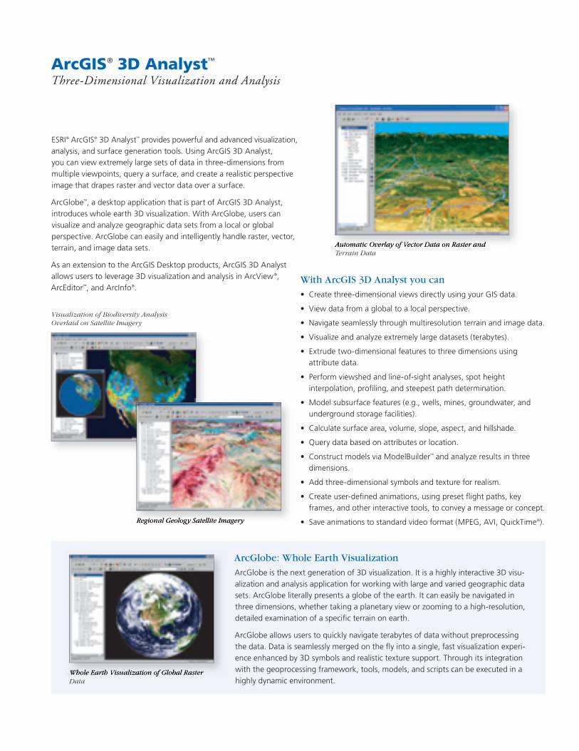
Automatic Overlay of Vector Data on Raster and Terrain Data
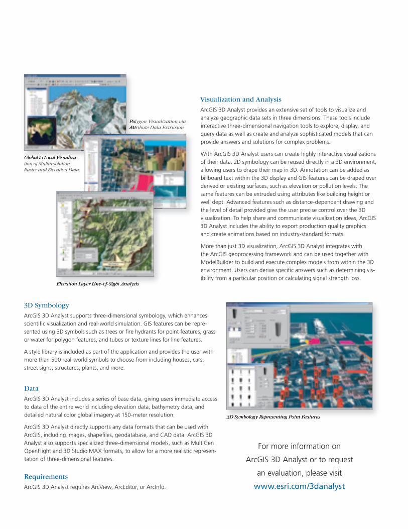
3D Symbology Representing Point Features
Whole Earth Visualization of Global Raster Data
Visualization of Biodiversity Analysis Overlaid on Satellite Imagery
Regional Geology Satellite Imagery
Global to Local Visualiza-tion of Multiresolution Raster and Elevation Data
Polygon Visualization via Attribute Data Extrusion
With ArcGIS 3D Analyst you can
• Create three-dimensional views directly using your GIS data.
• View data from a global to a local perspective.
• Navigate seamlessly through multiresolution terrain and image data.
• Visualize and analyze extremely large datasets (terabytes).
• Extrude two-dimensional features to three dimensions using attribute data.
• Perform viewshed and line-of-sight analyses, spot height interpolation, profi ling, and steepest path determination.
• Model subsurface features (e.g., wells, mines, groundwater, and underground storage facilities).
• Calculate surface area, volume, slope, aspect, and hillshade.
• Query data based on attributes or location.
• Construct models via ModelBuilder™ and analyze results in three
dimensions.
• Add three-dimensional symbols and texture for realism.
• Create user-defi ned animations, using preset fl ight paths, key frames, and other interactive tools, to convey a message or concept.
• Save animations to standard video format (MPEG, AVI, QuickTime®).
For more information on
ArcGIS 3D Analyst or to request
an evaluation, please visit
www.esri.com/3danalyst
Elevation Layer Line-of-Sight Analysis
ArcGlobe: Whole Earth Visualization
ArcGlobe is the next generation of 3D visualization. It is a highly interactive 3D visu-alization and analysis application for working with large and varied geographic data sets. ArcGlobe literally presents a globe of the earth. It can easily be navigated in three dimensions, whether taking a planetary view or zooming to a high-resolution, detailed examination of a specifi c terrain on earth.
ArcGlobe allows users to quickly navigate terabytes of data without preprocessing the data. Data is seamlessly merged on the fl y into a single, fast visualization experi-ence enhanced by 3D symbols and realistic texture support. Through its integration with the geoprocessing framework, tools, models, and scripts can be executed in a highly dynamic environment.
Data
ArcGIS 3D Analyst includes a series of base data, giving users immediate access to data of the entire world including elevation data, bathymetry data, and detailed natural color global imagery at 150-meter resolution.
ArcGIS 3D Analyst directly supports any data formats that can be used with ArcGIS, including images, shapefi les, geodatabase, and CAD data. ArcGIS 3D Analyst also supports specialized three-dimensional models, such as MultiGen OpenFlight and 3D Studio MAX formats, to allow for a more realistic represen-tation of three-dimensional features.
Requirements
ArcGIS 3D Analyst requires ArcView, ArcEditor, or ArcInfo.
3D Symbology Representing Point Features
Automatic Overlay of Vector Data on Raster and
Whole Earth Visualization of Global Raster
Regional Geology Satellite Imagery
Global to Local Visualiza-
Polygon Visualization via Attribute Data Extrusion
Elevation Layer Line-of-Sight Analysis
Three-Dimensional Visualization and Analysis
ArcGIS®
3D Analyst™
Australiawww.esriaustralia.com.au
Belgium/Luxembourgwww.esribelux.com
Bulgariawww.esribulgaria.com
Canadawww.esricanada.com
China (Beijing)www.esrichina-bj.cn
China (Hong Kong)www.esrichina-hk.com
Finlandwww.esri-fi nland.com
Francewww.esrifrance.fr
Germany/Switzerlandwww.esri-germany.de
www.esri-suisse.ch
Hungarywww.esrihu.hu
Indiawww.esriindia.com
Indonesia/Malaysia62-21-527-1023603-7874-9930
Italywww.esriitalia.it
Japanwww.esrij.com
Koreawww.esrikr.co.kr
Netherlandswww.esrinl.com
Polandwww.esripolska.com.pl
Portugalwww.esri-portugal.pt
Romaniawww.esriro.ro
Singaporewww.esrisa.com
Spainwww.esri-es.com
Swedenwww.esri-sweden.com
Thailandwww.esrith.com
United Kingdomwww.esriuk.com
Venezuelawww.esriven.com
No. GS-35F-5086H
Printed in USA96830INLD10M7/04dh/tk
Copyright © 2004 ESRI. All rights reserved. ESRI, the ESRI globe logo, ArcGIS, 3D Analyst, ArcGlobe, ArcView, ModelBuilder, ArcEditor, ArcInfo, @esri.com, and www.esri.com are trademarks, registered trademarks, or service marks of ESRI in the United States, the European Community, or certain other jurisdictions. Other companies and products mentioned herein are trademarks or registered trademarks of their respective trademark owners.
Place ESRI business partner or distributor address here.
For more than 30 years ESRI has been helping people manage and analyze geographic information. ESRI offers a framework for implementing GIS technology in any organization with a seamless link from personal GIS on the desktop
to enterprisewide GIS client/server and data management systems. ESRI GIS solutions are fl exible and can be customized to meet the needs of our users. ESRI is a full-service GIS company, ready to help you begin, grow, and build success with GIS.
International Offi ces
ESRI
380 New York Street
Redlands, California
92373-8100, USA
Telephone: 909-793-2853
Fax: 909-793-5953
For more information
on ESRI, call
1-800-447-9778(1-800-GIS-XPRT)
or contact an ESRI reseller near you.
Send e-mail inquiries to
Visit ESRI’s Web page at
www.esri.com
Corporate
Outside the United States,
contact your local ESRI distributor.
For the number of your distributor,
call ESRI at 909-793-2853,
ext. 1235,
or visit our Web site at
www.esri.com/international
Regional Offi ces
ESRI–Minneapolis 651-454-0600 ESRI–Olympia
360-754-4727ESRI–Boston 978-777-4543
ESRI–California909-793-2853 ext. 1-1906
ESRI–Denver 303-449-7779
ESRI–San Antonio 210-499-1044
ESRI–Charlotte704-541-9810
ESRI–Washington, D.C.703-506-9515
ESRI–St. Louis 636-949-6620ESRI–Philadelphia
610-337-8380
ESRI–New York City212-349-3700
ArcGIS® 3D Analyst™
Three-Dimensional Visualization and Analysis
ESRI® ArcGIS® 3D Analyst™ provides powerful and advanced visualization,analysis, and surface generation tools. Using ArcGIS 3D Analyst, you can view extremely large sets of data in three-dimensions from multiple viewpoints, query a surface, and create a realistic perspective image that drapes raster and vector data over a surface.
ArcGlobe™, a desktop application that is part of ArcGIS 3D Analyst, introduces whole earth 3D visualization. With ArcGlobe, users can visualize and analyze geographic data sets from a local or global perspective. ArcGlobe can easily and intelligently handle raster, vector, terrain, and image data sets.
As an extension to the ArcGIS Desktop products, ArcGIS 3D Analyst allows users to leverage 3D visualization and analysis in ArcView®, ArcEditor™, and ArcInfo®.
Visualization and Analysis
ArcGIS 3D Analyst provides an extensive set of tools to visualize and analyze geographic data sets in three dimensions. These tools include interactive three-dimensional navigation tools to explore, display, and query data as well as create and analyze sophisticated models that can provide answers and solutions for complex problems.
With ArcGIS 3D Analyst users can create highly interactive visualizations of their data. 2D symbology can be reused directly in a 3D environment, allowing users to drape their map in 3D. Annotation can be added as billboard text within the 3D display and GIS features can be draped over derived or existing surfaces, such as elevation or pollution levels. The same features can be extruded using attributes like building height or well dept. Advanced features such as distance-dependant drawing and the level of detail provided give the user precise control over the 3D visualization. To help share and communicate visualization ideas, ArcGIS 3D Analyst includes the ability to export production quality graphics and create animations based on industry-standard formats.
More than just 3D visualization, ArcGIS 3D Analyst integrates with the ArcGIS geoprocessing framework and can be used together with ModelBuilder to build and execute complex models from within the 3D environment. Users can derive specifi c answers such as determining vis-ibility from a particular position or calculating signal strength loss.
3D Symbology
ArcGIS 3D Analyst supports three-dimensional symbology, which enhances scientifi c visualization and real-world simulation. GIS features can be repre-sented using 3D symbols such as trees or fi re hydrants for point features, grass or water for polygon features, and tubes or texture lines for line features.
A style library is included as part of the application and provides the user with more than 500 real-world symbols to choose from including houses, cars, street signs, structures, plants, and more.
Automatic Overlay of Vector Data on Raster and Terrain Data
3D Symbology Representing Point Features
Whole Earth Visualization of Global Raster Data
Visualization of Biodiversity Analysis Overlaid on Satellite Imagery
Regional Geology Satellite Imagery
Global to Local Visualiza-tion of Multiresolution Raster and Elevation Data
Polygon Visualization via Attribute Data Extrusion
With ArcGIS 3D Analyst you can
• Create three-dimensional views directly using your GIS data.
• View data from a global to a local perspective.
• Navigate seamlessly through multiresolution terrain and image data.
• Visualize and analyze extremely large datasets (terabytes).
• Extrude two-dimensional features to three dimensions using attribute data.
• Perform viewshed and line-of-sight analyses, spot height interpolation, profi ling, and steepest path determination.
• Model subsurface features (e.g., wells, mines, groundwater, and underground storage facilities).
• Calculate surface area, volume, slope, aspect, and hillshade.
• Query data based on attributes or location.
• Construct models via ModelBuilder™ and analyze results in three dimensions.
• Add three-dimensional symbols and texture for realism.
• Create user-defi ned animations, using preset fl ight paths, key frames, and other interactive tools, to convey a message or concept.
• Save animations to standard video format (MPEG, AVI, QuickTime®).
For more information on
ArcGIS 3D Analyst or to request
an evaluation, please visit
www.esri.com/3danalyst
Elevation Layer Line-of-Sight Analysis
ArcGlobe: Whole Earth Visualization
ArcGlobe is the next generation of 3D visualization. It is a highly interactive 3D visu-alization and analysis application for working with large and varied geographic data sets. ArcGlobe literally presents a globe of the earth. It can easily be navigated in three dimensions, whether taking a planetary view or zooming to a high-resolution, detailed examination of a specifi c terrain on earth.
ArcGlobe allows users to quickly navigate terabytes of data without preprocessing the data. Data is seamlessly merged on the fl y into a single, fast visualization experi-ence enhanced by 3D symbols and realistic texture support. Through its integration with the geoprocessing framework, tools, models, and scripts can be executed in a highly dynamic environment.
Data
ArcGIS 3D Analyst includes a series of base data, giving users immediate access to data of the entire world including elevation data, bathymetry data, and detailed natural color global imagery at 150-meter resolution.
ArcGIS 3D Analyst directly supports any data formats that can be used with ArcGIS, including images, shapefi les, geodatabase, and CAD data. ArcGIS 3D Analyst also supports specialized three-dimensional models, such as MultiGen OpenFlight and 3D Studio MAX formats, to allow for a more realistic represen-tation of three-dimensional features.
Requirements
ArcGIS 3D Analyst requires ArcView, ArcEditor, or ArcInfo.
3D Symbology Representing Point Features
Automatic Overlay of Vector Data on Raster and
Whole Earth Visualization of Global Raster
Regional Geology Satellite Imagery
Global to Local Visualiza-
Polygon Visualization via Attribute Data Extrusion
Elevation Layer Line-of-Sight Analysis

Three-Dimensional Visualization and Analysis
ArcGIS® 3D Analyst™
Australiawww.esriaustralia.com.au
Belgium/Luxembourgwww.esribelux.com
Bulgariawww.esribulgaria.com
Canadawww.esricanada.com
China (Beijing)www.esrichina-bj.cn
China (Hong Kong)www.esrichina-hk.com
Finlandwww.esri-fi nland.com
Francewww.esrifrance.fr
Germany/Switzerlandwww.esri-germany.de
www.esri-suisse.ch
Hungarywww.esrihu.hu
Indiawww.esriindia.com
Indonesia/Malaysia62-21-527-1023603-7874-9930
Italywww.esriitalia.it
Japanwww.esrij.com
Koreawww.esrikr.co.kr
Netherlandswww.esrinl.com
Polandwww.esripolska.com.pl
Portugalwww.esri-portugal.pt
Romaniawww.esriro.ro
Singaporewww.esrisa.com
Spainwww.esri-es.com
Swedenwww.esri-sweden.com
Thailandwww.esrith.com
United Kingdomwww.esriuk.com
Venezuelawww.esriven.com
No. GS-35F-5086H
Printed in USA96830INLD10M7/04dh/tk
Copyright © 2004 ESRI. All rights reserved. ESRI, the ESRI globe logo, ArcGIS, 3D Analyst, ArcGlobe, ArcView, ModelBuilder, ArcEditor, ArcInfo, @esri.com, and www.esri.com are trademarks, registered trademarks, or service marks of ESRI in the United States, the European Community, or certain other jurisdictions. Other companies and products mentioned herein are trademarks or registered trademarks of their respective trademark owners.
Place ESRI business partner or distributor address here.
For more than 30 years ESRI has been helping people manage and analyze geographic information. ESRI offers a framework for implementing GIS technology in any organization with a seamless link from personal GIS on the desktop
to enterprisewide GIS client/server and data management systems. ESRI GIS solutions are fl exible and can be customized to meet the needs of our users. ESRI is a full-service GIS company, ready to help you begin, grow, and build success with GIS.
International Offi ces
ESRI
380 New York Street
Redlands, California
92373-8100, USA
Telephone: 909-793-2853
Fax: 909-793-5953
For more information
on ESRI, call
1-800-447-9778(1-800-GIS-XPRT)
or contact an ESRI reseller near you.
Send e-mail inquiries to
Visit ESRI’s Web page at
www.esri.com
Corporate
Outside the United States,
contact your local ESRI distributor.
For the number of your distributor,
call ESRI at 909-793-2853,
ext. 1235,
or visit our Web site at
www.esri.com/international
Regional Offi ces
ESRI–Minneapolis 651-454-0600ESRI–Olympia
360-754-4727ESRI–Boston 978-777-4543
ESRI–California909-793-2853 ext. 1-1906
ESRI–Denver 303-449-7779
ESRI–San Antonio 210-499-1044
ESRI–Charlotte704-541-9810
ESRI–Washington, D.C.703-506-9515
ESRI–St. Louis 636-949-6620 ESRI–Philadelphia
610-337-8380
ESRI–New York City212-349-3700
ArcGIS® 3D Analyst
™
Three-Dimensional Visualization and Analysis
ESRI® ArcGIS
® 3D Analyst
™ provides powerful and advanced visualization,
analysis, and surface generation tools. Using ArcGIS 3D Analyst, you can view extremely large sets of data in three-dimensions from multiple viewpoints, query a surface, and create a realistic perspective image that drapes raster and vector data over a surface.
ArcGlobe™, a desktop application that is part of ArcGIS 3D Analyst,
introduces whole earth 3D visualization. With ArcGlobe, users can visualize and analyze geographic data sets from a local or global perspective. ArcGlobe can easily and intelligently handle raster, vector, terrain, and image data sets.
As an extension to the ArcGIS Desktop products, ArcGIS 3D Analyst allows users to leverage 3D visualization and analysis in ArcView
®,
ArcEditor™, and ArcInfo
®.
Visualization and Analysis
ArcGIS 3D Analyst provides an extensive set of tools to visualize and analyze geographic data sets in three dimensions. These tools include interactive three-dimensional navigation tools to explore, display, and query data as well as create and analyze sophisticated models that can provide answers and solutions for complex problems.
With ArcGIS 3D Analyst users can create highly interactive visualizations of their data. 2D symbology can be reused directly in a 3D environment, allowing users to drape their map in 3D. Annotation can be added as billboard text within the 3D display and GIS features can be draped over derived or existing surfaces, such as elevation or pollution levels. The same features can be extruded using attributes like building height or well dept. Advanced features such as distance-dependant drawing and the level of detail provided give the user precise control over the 3D visualization. To help share and communicate visualization ideas, ArcGIS 3D Analyst includes the ability to export production quality graphics and create animations based on industry-standard formats.
More than just 3D visualization, ArcGIS 3D Analyst integrates with the ArcGIS geoprocessing framework and can be used together with ModelBuilder to build and execute complex models from within the 3D environment. Users can derive specifi c answers such as determining vis-ibility from a particular position or calculating signal strength loss.
3D Symbology
ArcGIS 3D Analyst supports three-dimensional symbology, which enhances scientifi c visualization and real-world simulation. GIS features can be repre-sented using 3D symbols such as trees or fi re hydrants for point features, grass or water for polygon features, and tubes or texture lines for line features.
A style library is included as part of the application and provides the user with more than 500 real-world symbols to choose from including houses, cars, street signs, structures, plants, and more.
Automatic Overlay of Vector Data on Raster and Terrain Data
3D Symbology Representing Point Features
Whole Earth Visualization of Global Raster Data
Visualization of Biodiversity Analysis Overlaid on Satellite Imagery
Regional Geology Satellite Imagery
Global to Local Visualiza-tion of Multiresolution Raster and Elevation Data
Polygon Visualization via Attribute Data Extrusion
With ArcGIS 3D Analyst you can
• Create three-dimensional views directly using your GIS data.
• View data from a global to a local perspective.
• Navigate seamlessly through multiresolution terrain and image data.
• Visualize and analyze extremely large datasets (terabytes).
• Extrude two-dimensional features to three dimensions using attribute data.
• Perform viewshed and line-of-sight analyses, spot height interpolation, profi ling, and steepest path determination.
• Model subsurface features (e.g., wells, mines, groundwater, and underground storage facilities).
• Calculate surface area, volume, slope, aspect, and hillshade.
• Query data based on attributes or location.
• Construct models via ModelBuilder™ and analyze results in three
dimensions.
• Add three-dimensional symbols and texture for realism.
• Create user-defi ned animations, using preset fl ight paths, key frames, and other interactive tools, to convey a message or concept.
• Save animations to standard video format (MPEG, AVI, QuickTime®).
For more information on
ArcGIS 3D Analyst or to request
an evaluation, please visit
www.esri.com/3danalyst
Elevation Layer Line-of-Sight Analysis
ArcGlobe: Whole Earth Visualization
ArcGlobe is the next generation of 3D visualization. It is a highly interactive 3D visu-alization and analysis application for working with large and varied geographic data sets. ArcGlobe literally presents a globe of the earth. It can easily be navigated in three dimensions, whether taking a planetary view or zooming to a high-resolution, detailed examination of a specifi c terrain on earth.
ArcGlobe allows users to quickly navigate terabytes of data without preprocessing the data. Data is seamlessly merged on the fl y into a single, fast visualization experi-ence enhanced by 3D symbols and realistic texture support. Through its integration with the geoprocessing framework, tools, models, and scripts can be executed in a highly dynamic environment.
Data
ArcGIS 3D Analyst includes a series of base data, giving users immediate access to data of the entire world including elevation data, bathymetry data, and detailed natural color global imagery at 150-meter resolution.
ArcGIS 3D Analyst directly supports any data formats that can be used with ArcGIS, including images, shapefi les, geodatabase, and CAD data. ArcGIS 3D Analyst also supports specialized three-dimensional models, such as MultiGen OpenFlight and 3D Studio MAX formats, to allow for a more realistic represen-tation of three-dimensional features.
Requirements
ArcGIS 3D Analyst requires ArcView, ArcEditor, or ArcInfo.
3D Symbology Representing Point Features
Automatic Overlay of Vector Data on Raster and
Whole Earth Visualization of Global Raster
Regional Geology Satellite Imagery
Global to Local Visualiza-
Polygon Visualization via Attribute Data Extrusion
Elevation Layer Line-of-Sight Analysis
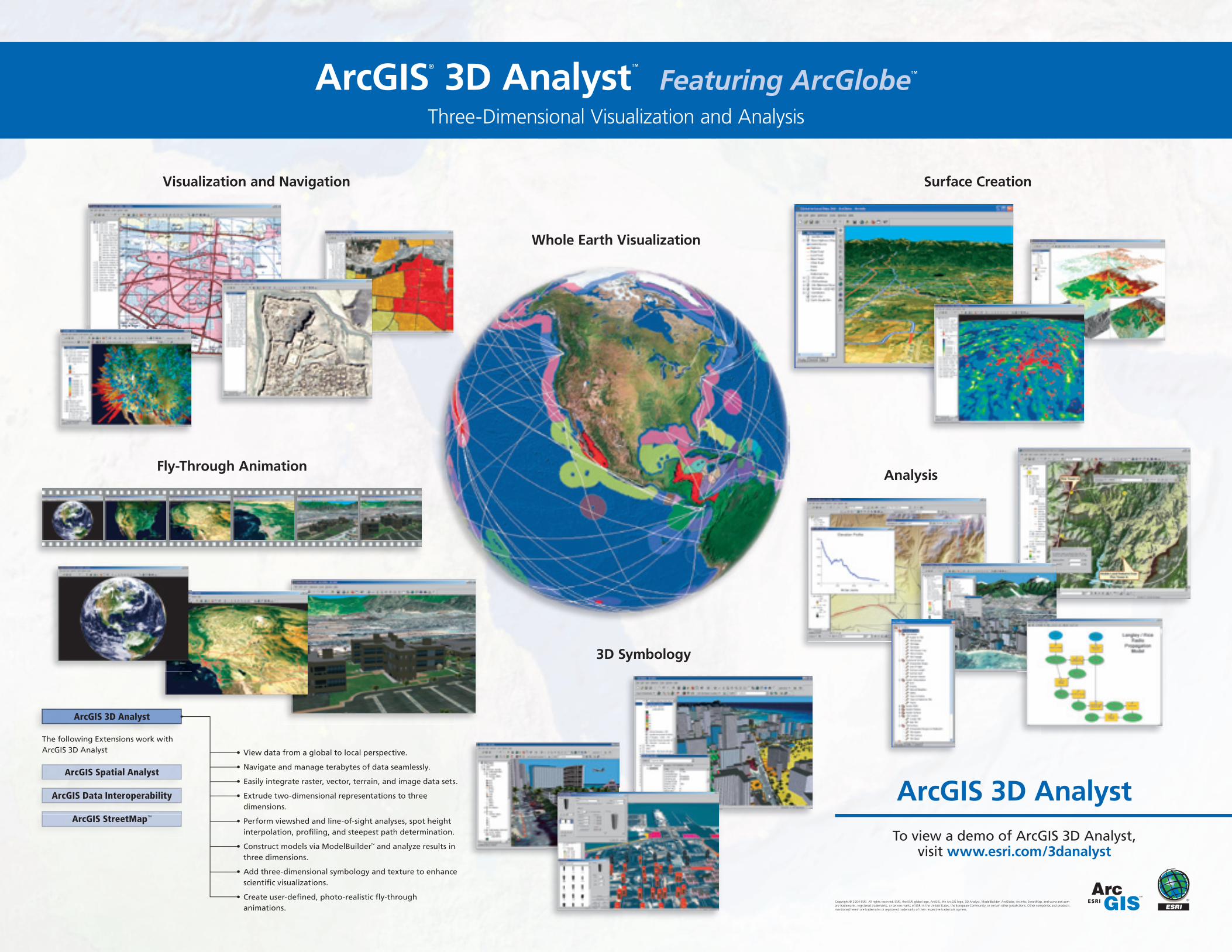
Visualization and Navigation Surface Creation
ArcGIS 3D AnalystTo view a demo of ArcGIS 3D Analyst,
visit www.esri.com/3danalyst
Copyright © 2004 ESRI. All rights reserved. ESRI, the ESRI globe logo, ArcGIS, the ArcGIS logo, 3D Analyst, ModelBuilder, ArcGlobe, ArcInfo, StreetMap, and www.esri.com are trademarks, registered trademarks, or service marks of ESRI in the United States, the European Community, or certain other jurisdictions. Other companies and products mentioned herein are trademarks or registered trademarks of their respective trademark owners.
ArcGIS® 3D Analyst™ Featuring ArcGlobe™
Three-Dimensional Visualization and Analysis
Fly-Through AnimationAnalysis
3D Symbology
Whole Earth Visualization
• View data from a global to local perspective.
• Navigate and manage terabytes of data seamlessly.
• Easily integrate raster, vector, terrain, and image data sets.
• Extrude two-dimensional representations to three dimensions.
• Perform viewshed and line-of-sight analyses, spot height interpolation, profi ling, and steepest path determination.
• Construct models via ModelBuilder™ and analyze results in three dimensions.
• Add three-dimensional symbology and texture to enhance scientifi c visualizations.
• Create user-defi ned, photo-realistic fl y-through animations.
ArcGIS 3D Analyst
ArcGIS Spatial Analyst
ArcGIS Data Interoperability
ArcGIS StreetMap™
The following Extensions work with ArcGIS 3D Analyst