3d elevation program products & services · 3d elevation program products & services + 2...
TRANSCRIPT

+
Scientific Technical Assessment & Reporting TeamChesapeake Bay ProgramSeptember 28, 2017
3D Elevation Program Products & Services

+ 2+ 2
3DEP IS A COLLABORATIVE
9 Federal Agency Members
Includes: state government, private, non-profit, academic, tribal agencies and groups
Non Feds participate via the Broad Agency Announcement (BAA)
Primarily leaf-off collection
Topographic lidar only – so far
Delivers data to a standard, standard deliverable data
Coordinated by USGS

+ 3+ 3
3DEP Data Contracted in FY16
3DEP Funds Partner Contributions Total
Project Value
Square Miles
USGS FEMA NRCS Other Feds
Non-Federal
Broad Agency
Announce-ment
$6.5 M $2.1 M $3.9 M $0.8 M $14.4 M$27.8 M 121.0 K
$12.5 M $15.2 M
Other partnerships
$2.7 M $9.9 M $6.1 M $0.6 M $2.0 M$21.2 M 82.1 K
$18.6 M $2.6 M
TOTAL$9.2 M $11.9 M $10.0 M $1.4 M $16.4 M
$49.0 M 203.1 K$31.2 M $17.8 M
PRELIMINARY Results – Subject to Change
Additional investments were made in FY16 that are being contracted in FY17: $44.8M Lidar; $1.2M for Alaska IfSAR
FY15 $39M and 150,000 square miles
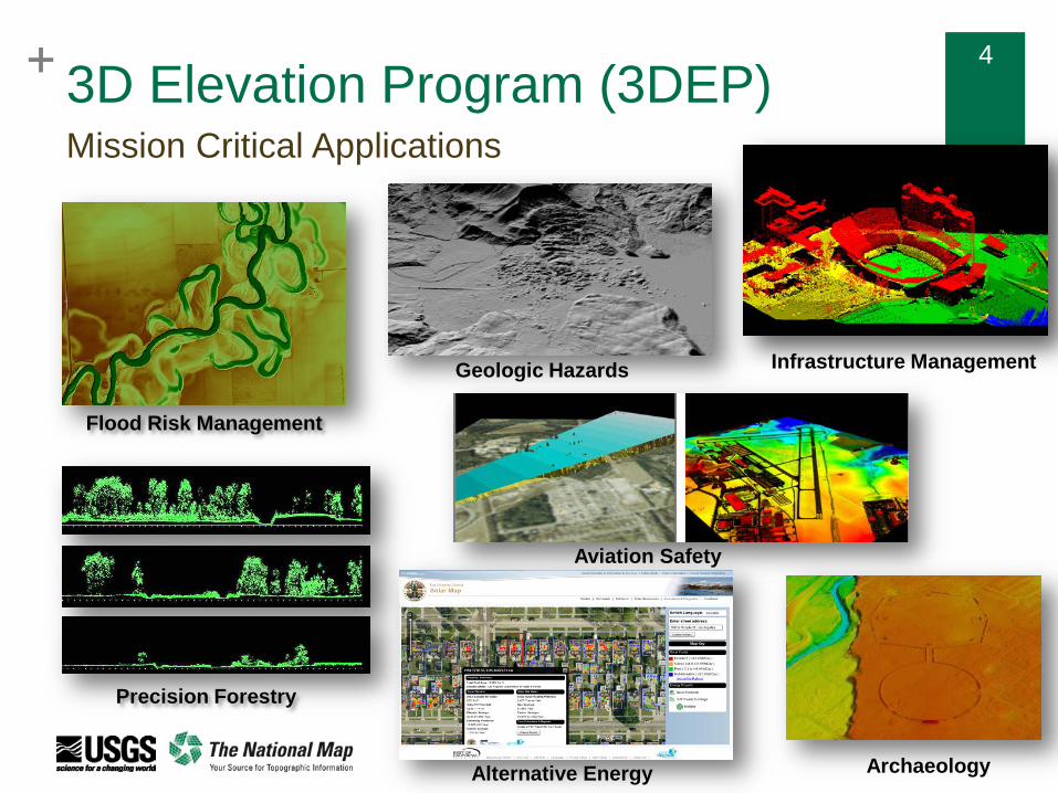
+ 4+ 43D Elevation Program (3DEP)Mission Critical Applications
Infrastructure ManagementGeologic Hazards
Archaeology
Precision Forestry
Aviation Safety
Flood Risk Management
Alternative Energy

+ 5+ 53DEP For America’s InfrastructureThe significant challenge of improving the Nation’s infrastructure depends on high-quality elevation data
Lidar point cloud (top) and a derived bare-earth digital elevation model (bottom) for Denver, CO
Uses include: Route, grade, line-of-sight, and utility surveys and
corridor mapping Terrain and other obstruction identification for aviation Dam, levee, and coastal-structure failure modeling and
mitigation Hydraulic and hydrologic modeling Evaluations of geologic, coastal, and other natural
hazards, and geotechnical evaluations Permit application and construction plan development
and evaluation Drainage issues and cut-and-fill estimate requirements Vegetation, topographic, and geomorphologic feature
analysis As-built model development Preliminary engineering, estimate development, and
quantity estimation activities Bridge site selection Base-map and elevation model creation

+ 6+ 6
Lidar Quality Levels
Quality Level Min pts/sq meter Pulse Spacing RMSEzQL1 8 About .35m 10cmQL2 2 .7 m 10cmQL3 .25 – 1 1-2m 18.5cm
Current 3DEP acquisition is QL2 Topographic Lidar

+ 7+ 7
3DEP Data AcquisitionSteps for Federal Agencies in BLUE
SubmitRequirement
3DEP Working Group – Look for BAA match
for Federal requirements
SEASKETCH
BAA project selected
No match
Data acquisition via GPSC
PREFERRED
Data acquisition via partner
contract
Match Found
3DEP Working Group – Look for Federal
funding
USGS compiles
annual Federal requirements
USGS solicits proposals via
BAA
To find website, search for Seasketch federal mapping coordination

+ 8+ 8
3DEP Deliverable Data and Reports
Metadata
Reports: collection, processing, QA/QC, surveyed control points, check points
Raw Point Cloud
Classified Point Cloud
Bare Earth 1m Grid DEM
Breaklines
Hydro-flattened water features

+ 93DEP Products Standard DEMs Nationally Seamless 2 Arc Second 1 Arc Second 1/3 Arc Second
Project-based (seamless within collection projects) 1/9 Arc Second (legacy) 1-meter 5-meter (Ifsar - Alaska)
Source Data Source DEMs (original product resolution) Lidar Point Cloud Digital Surface Model (Ifsar - Alaska) Orthorectified Radar Intensity Imagery (Ifsar - Alaska)
Previously referred to as the National Elevation Dataset (NED)

+ 10
1-meter1/3 arc-second
1/9 arc-second(Legacy Only)
1 arc-second
3DEP Standard DEM Products (Lidar source)

+ 11
Lidar Point Cloud • Point classifications
• Original Spatial Reference
• Original Tile Size
• Format: LAS
LAZ-compressed (2017)

+ 12
Elevation Web Services
Point Query Service Elevation at x, y – single point or bulk query Interpolates from 1/3 arc second seamless DEM
Coming in FY17: Image service for DEM viewing applications (shaded relief,
slope, aspect, etc.) GRiD service for viewing and download of lidar point cloud
within area of interest

+ 13
Simple Bay Watershed Coverage Map

+ 14Current Lidar Coverage Status With Quality Level

+ 15Watch for new Products & Services atNationalmap.gov/3dep/

+ 16
Inland Bathymetry Technology proven in
coastal areas
Initial tests by EAARL-B in Delaware River were promising
Commercial sensors becoming available
Begin assessments of commercial capabilities in FY17
Frenchtown Subregion of the Delaware River, integrated EAARL-B and topographic lidar

+ 17
Thank you!