3d structure of the gusev crater region - universiteit...
TRANSCRIPT
Earth and Planetary Science Letters 294 (2010) 411–423
Contents lists available at ScienceDirect
Earth and Planetary Science Letters
j ourna l homepage: www.e lsev ie r.com/ locate /eps l
3D structure of the Gusev Crater region
Mirjam van Kan Parker a,⁎, Tanja Zegers b, Thomas Kneissl c, Boris Ivanov d,Bernard Foing e, Gerhard Neukum c
a Faculty of Earth and Life Sciences, VU University Amsterdam, De Boelelaan 1085, 1081 HV Amsterdam, The Netherlandsb Faculty of Geosciences, Utrecht University, Budapestlaan 4, 3508 TA, Utrecht, The Netherlandsc Institute of Geosciences, Planetology and Remote Sensing, Freie Universtaet Berlin, Malteserstrasse 74-100, Bldg D, 12249 Berlin, Germanyd Institute for Dynamics of Geospheres, Russian Academy of Sciences, Leninsky Prospekt 38, Moscow 119334, Russiae European Space Agency (ESA), European Space & Technology Centre (ESTEC), P.O.Box 299, 2200 AG Noordwijk, The Netherlands
⁎ Corresponding author. Tel.: +31 20 5983725; fax: +E-mail addresses: [email protected] (M. va
(T. Zegers), [email protected] (T. Kneissl), [email protected] (B. Foing), [email protected]
0012-821X/$ – see front matter © 2010 Elsevier B.V. Adoi:10.1016/j.epsl.2010.01.013
a b s t r a c t
a r t i c l e i n f oArticle history:Accepted 7 January 2010Available online 29 January 2010
Keywords:MarsGusev Craterstructural geologystratigraphyColumbia Hillscrater count ages
Gusev Crater lies within the Aeolis Quadrangle of Mars at the boundary between the northern lowlands andsouthern highlands. The ancient valley Ma'adim Vallis dissects the highlands south of Gusev Crater and isthought to have fed the crater with sediments.High Resolution Stereo Camera data and Digital Elevation Models were used to construct a geologic–geomorphic map (173.5–178.5° E, 10–18° S) and cross-sections, complemented by data from Mars OrbiterCamera, Mars Orbiter Laser Altimeter and Thermal Emission Imaging System.Three geologic domains are recognised: the highlands in the south, Gusev Crater and lowlands in the north.Twelve units are mapped, with thicknesses ranging from hundred meters to several kilometres. Thicknessesof units, and their bedding attitude, are estimated combining the geologic map and topographic information.Relative ages are determined from crater counts, ranging from Early Noachian for highland units to MiddleAmazonian for units in Gusev Crater and in lowlands. Episodes of intense geologic activity (deposition,volcanism, deformation) occur at around 4.0 Ga, 3.7 Ga, and 3.5 Ga. Comparing the geometry of the GusevCrater with similar sized, filled and un-filled, Martian craters, suggests that the Columbia Hills are relics ofthe original central peak of Gusev Crater.
31 20 5989942.n Kan Parker), [email protected]@ints.ru (B. Ivanov),rlin.de (G. Neukum).
ll rights reserved.
© 2010 Elsevier B.V. All rights reserved.
1. Introduction
Unravelling the geologic evolution of a planetary region requiresintegration of high quality satellite data, ideally combined with in-situanalytical data and observations from a lander or rover. Understandingthe wider geological context of an area is essential to analyse lander orrover data. Traditionally, geological and morphological analyses areprimarily based on images complemented with topographic data (Scottet al., 1978; Greeley and Guest, 1987). The present study focuses onintegrating geological analyses in three dimensions using primarily HighResolution Stereo Camera (HRSC) data, in order to understand strati-graphic and structural relations. The aim of this paper is to construct thegenetic origin of the Columbia Hills, the Gusev Crater floor, (sub) surfaceand immediate surroundings.
Gusev Crater was the landing site for the Mars Exploration Rover(MER) Spirit, in January 2004 and provided critical ground observation
data (e.g. Squyres et al., 2004, 2006; McSween et al., 2004, 2006a,b;McCoy et al., 2008). Moreover, Gusev Crater region provides a sectionthrough an important part of theMartian upper crust. It is situated closeto the north–south dichotomy and may have served as a sedimentarybasin for Ma'adim Vallis (e.g. Schneeberger, 1989; Grin and Cabrol,1997; Kuzmin et al., 2000; Irwin et al., 2002), a valley dissecting thehighlands south of the crater. Gusev Crater region provides a record ofthe geologic history from early Noachian to present, with records ofimpacts, volcanics, fluvial-, hydrothermal and tectonic activity.
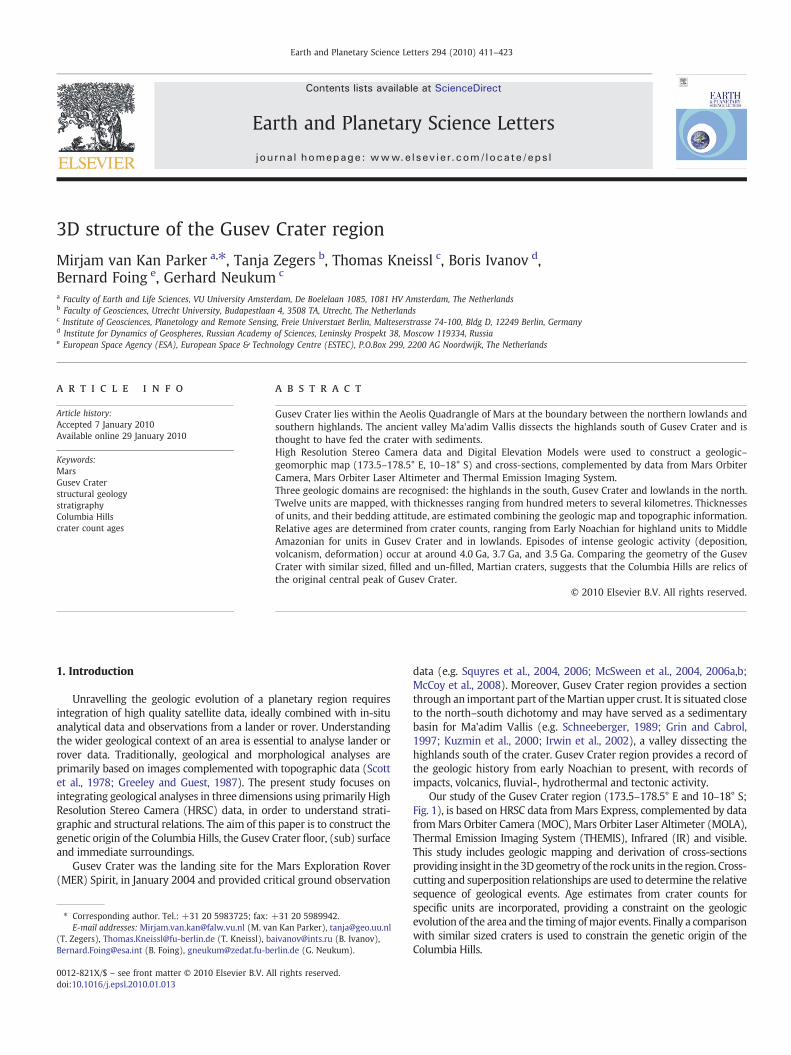
Our study of the Gusev Crater region (173.5–178.5° E and 10–18° S;Fig. 1), is based on HRSC data fromMars Express, complemented by datafromMars Orbiter Camera (MOC), Mars Orbiter Laser Altimeter (MOLA),Thermal Emission Imaging System (THEMIS), Infrared (IR) and visible.This study includes geologic mapping and derivation of cross-sectionsproviding insight in the3Dgeometry of the rockunits in the region. Cross-cutting and superposition relationships are used to determine the relativesequence of geological events. Age estimates from crater counts forspecific units are incorporated, providing a constraint on the geologicevolution of the area and the timing ofmajor events. Finally a comparisonwith similar sized craters is used to constrain the genetic origin of theColumbia Hills.
412 M.K. Parker et al. / Earth and Planetary Science Letters 294 (2010) 411–423
2. Geological context
The study area shows a variety of interesting geological features.The prime feature is the Noachian aged (Kuzmin et al., 2000) GusevCrater itself. It has a rim to rim diameter of ∼160 km centred at∼14.64° S and 175.36° E. The rim of themostly filled crater is relativelywell preserved, despite some craters superimposed on it. Previousregional studies include those by Scott et al. (1978), Greeley and Guest(1987), Grin and Cabrol (1997) and Kuzmin et al. (2000).
Other features in the area include the southern flank of theApollinaris Patera volcano, the Medusae Fossae Formation in thenortheast, the chaotic terrain in the degraded de Vaucouleurs Crater
Fig. 1. a) Geologic map of the Gusev Crater region bounded by the coordinates 173.5–178Outlined areas are the image locations for Fig. 3, a= Fig. 3a; b= 3b etc. Names of numberedcontext image of the mapped region.
in the west and surrounding highlands. Apollinaris Patera is anancient shield volcano with central vent system and multiple flows,having properties consistent with basalt (Greeley and Spudis, 1981).The final stage of volcanic activity was the emplacement of depositson its southern flank described as the more competent deposit of thevolcanic construct (Robinson et al., 1993). The Medusae FossaeFormation typically occurs in equatorial regions and has beendescribed as an extensive, geologically young and wind-scoureddeposit (Scott and Tanaka, 1986; Greeley and Guest, 1987; Bradleyet al., 2002; Carter et al., 2009). The Vaucouleurs chaotic terrain is partof a chain of chaotic terrains found along the dichotomy boundary(Sharp, 1973).
.5° E, 10–18° S. Geologic cross-section (Fig. 2) locations are marked in black capitals.craters are: 1= Zutphen; 2=Galdakao; 3= Thira. b) Legend to the geological map and

Fig. 1 (continued).
413M.K. Parker et al. / Earth and Planetary Science Letters 294 (2010) 411–423
Gusev Crater is generally thought to hold clues to early fluvialactivity on Mars, because Ma'adim Vallis has been interpreted asancient fluvial system dissecting the highlands south of the crater. It is∼900 km long, has an average width of 15 km, incises Gusev Crater'ssouthern rim and empties into the crater. Putative sedimentstransported by Ma'adim Vallis would have been deposited withinthe crater (Sharp and Malin, 1975; Schneeberger, 1989; Grin andCabrol, 1997; Cabrol et al., 1998; Kuzmin et al., 2000; Irwin et al.,2002; Cabrol et al., 2003; Irwin et al., 2004) and a Gilbert-type deltawould have formed (Kleinhans, 2005). This sedimentary interpreta-tion was the basis for its selection as the landing site for MarsExploration Rover (MER) Spirit (Golombek et al., 2003). It is thoughtto be a prime site to provide clues to an early (wet) Mars. Inanticipation of Spirit's landing Milam et al. (2003) used THEMIS andother data to characterise the deposits within the crater.
In contrast to the sedimentary interpretation, Spirit showed thatthe plains surrounding the landing site are composed of picriticbasaltic lavas unaltered by aqueous processes (e.g. McSween et al.,2004; Golombek et al., 2006; Grant et al., 2006). Martinez-Alonso et al.(2005) and Greeley et al. (2005) showed that these basaltic plainscharacterising most of the crater floor postdate other crater fillmaterials, such as putative sediments deposited by Ma'adim Vallis.
Data returned by Spirit, as well as orbital data (Martinez-Alonsoet al., 2005) have shown that the Columbia Hills are embayed by thesurrounding basaltic plains. The Columbia Hills vary compositionally
from the surrounding basalts (Morris et al., 2006; Golombek et al.,2006; Squyres et al., 2006; McSween et al., 2006a,b; Wang et al.,2006a,b; Clark et al., 2007). Various rocks were analysed in ColumbiaHills, including those high in phosphorous, potential pyroclastic orimpact materials (so-called Wishstone class rocks; Squyres et al.,2006) and aqueously altered rocks (so-called Clovis and Washtowerclass rocks; Squyres et al., 2006; Clark et al., 2007). McCoy et al. (2008)used 3D imaging software to show that the dips of bedding on themain edifice of Columbia Hills are steeper than the local topographyand that there is a significant variation in dip angle within ColumbiaHills.
3. Methodology
3.1. Image data and mapping
HRSC data (0.68 μm), stereoscopic anaglyphs and Digital ElevationModels (DEM's) were used for the geologic–geomorphic mapping andconstruction of geologic cross-sections. Units were mapped based onmorphological and thermophysical characteristics, similar to theapproach of Milam et al. (2003). Morphology and structure werederived from (stereo) image data (HRSC, THEMIS IR day, MOC) andthermophyscial properties (albedo and thermal inertia) were addi-tionally derived fromHRSC and THEMIS IR image data. Inertia gives anindication to the type of material, i.e. compact rocky material, as
414 M.K. Parker et al. / Earth and Planetary Science Letters 294 (2010) 411–423
opposed to loose dust (Mellon et al., 2000). Thermophysical charac-teristics were qualitatively assessed. Albedo was defined as low (darkareas) or high (light areas). Day and night temperatures were assessedusing THEMIS IR images,where dark reflects cold areas and light reflectswarm regions. Unit boundaries were mapped based on unit character-istics (thermophysical andmorphological properties, Table 1) andbreak
Table 1Summary of the units present within the mapped area.
Unit Morphology and structures Thermophysical prope
LowlandsMedusae Fossae -Undulating surface High albedo, moderate
and cold night tempera-Large elevation differences-Layering S boundary-Narrow spaced ridges∼NS orientated
Zutphen -Cut by increasing number of groovesand channels near Zutphen andGaldakao craters
High albedo, moderateand moderate (in W) to(in E) night temperature
Galdakao East -Generally smooth surface High albedo, moderatemoderate to cold day acold night temperature
-Buttes and knobs concentrated inthe centre, attaining heights of 200 m.-Local presence of subdued ridges-Varying degree of erosion, locallyetched surface
Galdakao West -Generally smooth surface High albedo, moderateand cold night temper-Local presence of subdued ridges
-Varying degree of erosion, locallyetched surface
Apollinaris -Arc shaped deposit High albedo, moderateand night temperatureincreasing from E to W
-Relatively smooth, slightly wavy-Layering within larger crater walls
Vaucouleurs -Presence of buttes and mesas invarying size, maximum 1 km high,increasing in size towards E, nospecific orientation
High albedo, with local pof low albedo, moderateand night temperatures,floors generally cold at n
Gusev CraterThira East -Etched, pitted and knobby surface High albedo, moderate
and hot with locally monight temperatures.
Thira North -Small subdued ridges, 100 m wide,trending NE–SW
High albedo, moderateand moderate–cold nigtemperatures.-Locally more pronounced ridges
-Rough terrainThira West -Locally knobby appearance High albedo, moderate
and night temperature-Presence of lobate margins
Gusev Crater -Generally smooth High albedo, moderateand night temperature-Few prominent ridges
-Craters: cold day and hot night T
HighlandsMa'adim Vallis -Cuts highlands S of Gusev High albedo, with loca
albedo patches, moderand night temperatureday and hot night tempat low albedo material.
-Streamlines upon entry in Gusev //to longitudinal axis of channel-Layered, flat topped mesas withinGusev inlet-Two main flooding levels, cut bytributary run-off channels
Highland members:Modified GusevGusev Mountainous
-Varying amount of grooves, valleysand run-off channels
High albedo, moderateand night temperature
-Rough, rugged, cratered terrainMountainous areas show steep,narrow ridges
1U.S.G.S. Equivalent Geologic Units Kuzmin et al. (2000); 2Milam et al. (2003); 3Martinez-A*Thicknesses are determined from geologic cross-sections, the thicknesses of units withinvariations.**Age has not been directly determined, but is constrained via a younger unnamed crater.***Age has not been directly determined, but is constrained via surrounding units.
of slope. Break of slope mapping is a technique traditionally used interrestrial geological mapping (Powell, 1992) and relates directly to themechanical and erosional properties of rock units. It is only with thecurrent availability of HRSC stereo data that this method using 3Dinformation, in the formof anaglyphs (AppendixA)orDEMs canbeusedfor geologicmappingonMars. The 3Dmappingmethod used resulted in
rties Thickness(m)*
Age(Ga)
Surface area usedfor crater count(km2)
Comparison to previousstudies
daytures.
? ** 174 1 Aml1, Aml2>1.13−0.56
+0.56
daycolds.
1500 3.52−0.08+0.05 614 1 Hpld
,nds.
>300 3.57−0.11+0.06 737 1 AHgf1, Hcht
dayatures.
≥900 3.85−0.15+0.15 1408 1 AHgf1,
days,.
1000 3.76−0.06+0.04 4707 –
atchdayvalleyight.
>700 (floor) *** – 1Achp, Hcht,Hpld, AHbm1600 (mesas) >3.85−0.15
+0.15
dayderate
200 2.89−0.44+0.28 737 1AHbm1
2Etched3Plains materials,High thermalinertia rough
dayht
100 3.52−0.16+0.08 644 1AHbm1
2Wrinked3Plains materials,Low thermal inertia
days.
80 3.31−0.17+0.09 321 1AHgf1
2Lobate3Plains materials,High thermalinertia smooth
days.
150 3.65−0.10+0.06 3241 1AHgf1, AHgf2
2Plains3Plains materials
l lowate days. Colderatures
>450 3.58−0.10+0.06
3.79−0.08+0.05
377 1AHbm1, AHch1,AHch2, AHch3
666 2Mesas, Ma'adim Vallis3Plains materials
days.
MG<100 3.72−0.07+0.05 886 1Npl, c1, HMpl1,
HMpl2, NmG>2500 4.04−0.10+0.06 2581
M>2000 3.95−0.07+0.05 631
lonso et al. (2005).the Gusev Crater serve as minimum thickness estimates, because of low topographic
415M.K. Parker et al. / Earth and Planetary Science Letters 294 (2010) 411–423
a geologic map and geologic cross-sections. The combination of thegeologic map and cross-sections provides insight in the geometry ofgeologic units, such as thickness and thickness variations and beddingattitude. Since Gusev Crater floor is relatively flat, the 3D information ofthe present units is limited. Therefore these particular unit thicknessesare not well constrained.
MOLA topographic gridded data, THEMIS infrared (IR) and visible-(IR-day: band 5, 9.35 μm; IR-night: band 9, 12.57 μm; visible band 3,0.65 μm) data and MOC (0.70 μm) images supplemented the HRSCanalysis. The HRSC data includes four orbits with an originalresolution of 25 m (24, 72, 283 and 335), that covered the areaobtained in the first year of Mars Express' operation, additionally orbit2249 was used, with an original resolution of 25 m. The DEM's(Gwinner et al., 2005) derived from these orbits have a resolution of100 m/pixel for orbits 24 and 72 and 200 m/pixel for orbits 283 and335. The anaglyphs were derived from the nadir and stereo 1 images,which were superimposed to produce a stereo effect and weregenerated as red and green images for stereo viewing.
The mapped area was covered by HRSC at 80%, 95% for THEMIS IRimages, 35% for THEMIS visible images and 5% coverage forMOC images.Geologic units were named after characteristic geographic features inthe area, following standard procedures for naming stratigraphic units.
3.2. Age determination
HRSC image mosaics with a resolution of 25 m/pixel were used forcrater count determination using the program “craterstats” (Michael andNeukum, 2010-this issue; Michael and Neukum, 2008). The cratermeasurements were recorded and partitioned into bins of increasingcrater size. These binned data were used to produce cumulative cratersize–frequencydistributionplots including statistical errors (AppendixA,e.g., Neukum and Wise, 1976; Neukum, 1983). Cumulative size–frequency distributions were analysed to determine crater frequenciesat specific reference diameters, 1-, 2-, 5-, 10-, and 16-km and cratermodel ages, following Hartmann and Neukum (2001). For more detailson the crater age determination method see Neukum et al. (2010-this
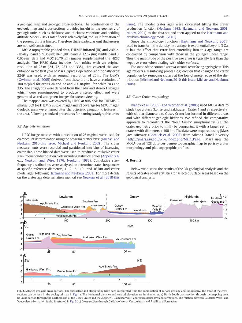
Fig. 2. Selected geologic cross-sections. The subsurface and stratigraphy have been interprsections can be seen in the geological map in Fig. 1a. The horizontal distance and verticalb) Cross-section through the northern rim of the Gusev Crater and the Zutphen-, Galdakao WVaucouleurs-Formation is also illustrated in Fig. 3f. c) Cross-section through Galdakao Wes
issue). The model crater ages were calculated fitting the craterproduction function (Neukum, 1983; Hartmann and Neukum, 2001;Ivanov, 2001) to the data set and then applied to the Hartmann andNeukum chronology model (2001).
Since the chronology function (Hartmann and Neukum, 2001)used to transform the density into an age, is exponential beyond 3 Ga,it has the effect that error-bars extending into this age range arecontracted by comparison with those in the younger linear range.Thus the magnitude of the positive age error is typically less than thenegative error when dealing with older surfaces.
For someof the counted areas a second, resurfacing age is given. Thisage reflects a resurfacing process, e.g. erosion that changed the craterpopulation by removing craters at the low-diameter edge of the dis-tribution (Michael and Neukum, 2010-this issue; Michael and Neukum,2008).
3.3. Gusev Crater morphology
Ivanov et al. (2005) and Werner et al. (2005) used MOLA data tostudy two craters (Lohse, and Bakhuysen, Crater 1 and 2 respectively)with similar diameters to Gusev Crater but located in different areasand with different geologic histories. We refined the comparativeapproach to reconstruct the “fresh Gusev” morphometry (i.e. thecrater geometry prior to infill) by comparing it with a larger set ofcraters with diameters >100 km. The data were acquired using JMarsJava software (Gorelick et al., 2003) from Arizona State University(http://jmars.asu.edu/wiki/index.php/Main_Page). JMars uses theMOLA-based 128 dots-per-degree topographic map to portray cratermorphology and plot topographic profiles.
4. Results
Below we discuss the results of the 3D geological analysis and theresults of crater count statistics for selected surface areas based on thegeological analysis.
eted from the combination of surface geology and topography. The trace of the cross-elevation are in kilometres. a) North South cross-section through the mapping area.est- and Vaucouleurs-lowland formations. The relation between Galdakao West- and
t-, Vaucouleurs- and Apollinaris Formation.

416 M.K. Parker et al. / Earth and Planetary Science Letters 294 (2010) 411–423
4.1. Geologic analysis
The 3D geological analysis of Gusev Crater and surrounding terrainresulted in a geologicalmap (Fig. 1) and geological cross-sections (Fig. 2).
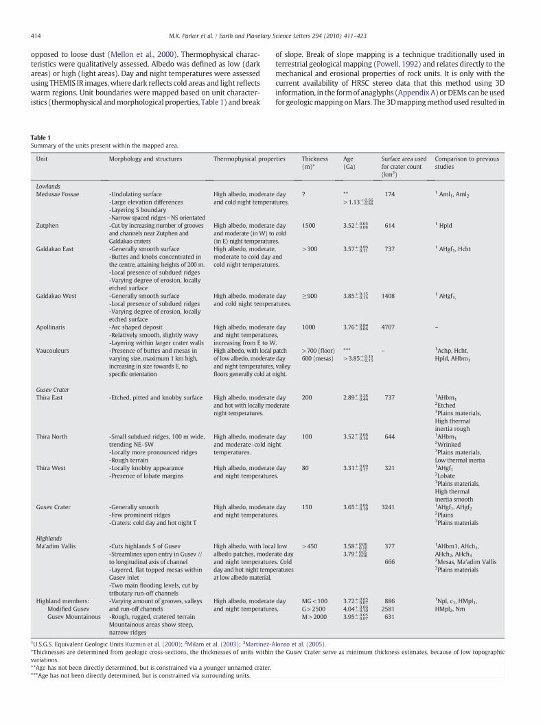
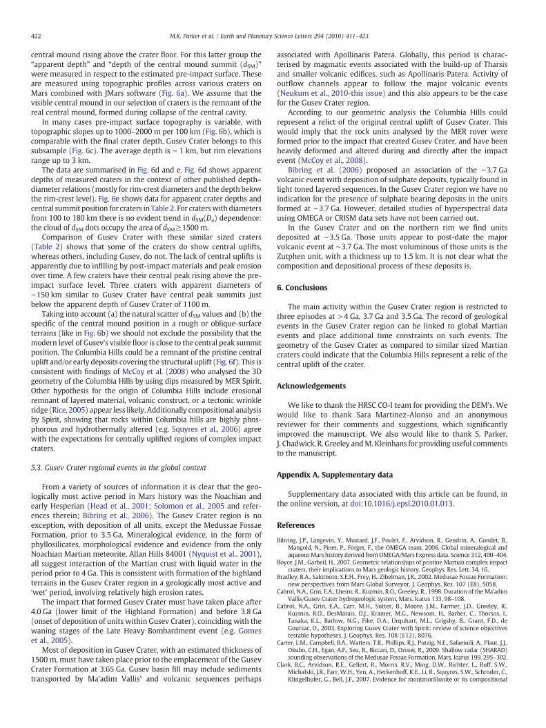
Fig. 3. Characteristic images of the different units, image locations are indicated on Fig. 1ahighlands surrounding Gusev a) sub-image from THEMIS visible image V07859003; b andsurrounding highlands and exposing horizontal layering. d) sub-images from THEMIS vishorizontal layering within the mesas. e and f) Characteristic images of the lowland terrain nand Galdakao Formation in the south, sub-image from HRSC orbit 335 f) boundary between(grey dotted line) and Vaucouleurs- and Galdakao West Formation (white dotted line) subFormation is gradational and shows no change in relief. However, the boundary betweendifferences. g and h) Characteristic images of the units within Gusev Crater g) boundary betand etched appearance of the latter, sub-image from THEMIS visible image V0158003characteristic for the Thira North Formation, sub-image from THEMIS visible image V05662
We distinguished three different geological terrains, each consisting of anumber of geological units: the Highland terrain (including the depositsrelated toMa'adimVallis), the Lowland terrain and the terrain interior toGusev Crater. The stratigraphy and geological relationships between
. a, b and c) Characteristic images of the rugged terrain and mountainous areas of thec) sub-images from HRSC orbit 283, c) illustrates the incision of Ma'adim Vallis in theible image V01942003 showing mesas of Ma'adim Vallis Formation, arrows indicateorth of Gusev Crater e) boundary between the Medusae Fossae Formation in the norththe Vaucouleurs- (V), Apollinaris (A) Formation and Galdakao West (GW) Formation-image from HRSC orbit 24. The boundary between the Vaucouleurs- and ApollinarisVaucouleurs- and Galdakao West Formation is characterised by relative large relief
ween Thira West- and Thira East Formation, showing the lobate character of the formerh) gradual transition of Thira East- and Thira North Formation, subdued ridges are001.

417M.K. Parker et al. / Earth and Planetary Science Letters 294 (2010) 411–423
units and terrains is describedbelow. For anoverviewof characteristics ofdifferent units and members in units see Table 1.
The highlands in the study area (Fig. 3a–c) are dominated byrugged terrains showing abundant small and large impact craters. Thelarge impact craters displayed relatively flat and smooth crater floors,which were subsequently mapped as potential impact sheets. Thehighlands are geologically complex, show thick horizontal layering(Fig. 3c) and have abundant erosional features, such as grooves andchannels. There are some mountainous areas present in the highlands(Fig. 3b), they are elevated up to ∼2 km above the surroundinghighlands and possibly include strato volcanoes (Greeley and Spudis,1978; Stewart and Head, 2001). We mapped the highlands in theregion as a single unit in which twomembers were distinguished: theGusev Highland Member and the Modified Gusev Highland Member.The Modified Gusev Highland Member generally shows fewer impactcraters and channels, and typically fills topographic lows formed bythe Highland member.
Ma'adim Vallis dissects the highlands, exposing various levels(Fig. 3c), and enters Gusev Crater from the south. Topographic dataindicates that the valley reaches depths of ∼2 km, which is hence theminimum thickness for the highlands. Including the thickness of themountainous areas provides us with a thickness estimate of thehighlands of several kilometres. The highlands are therefore the thickbasement, shown in cross-section in Fig. 2a, andmostwidespread unitin the Gusev Crater region.
Ma'adim Vallis Formation consists of two members: the flattoppedmesas within Gusev Crater and the valley floor (Fig. 1), the agerelationship with Gusev Crater Formation is not clear. Based onmorphology, Gusev Crater Formation appears to embay Ma'adimVallis Formation, which would imply a younger age of the former(Fig. 2a, b). However, based on these observations we cannot excludethat Ma'adim Vallis Formation is superposed on Gusev CraterFormation. Layers are observed within the mesas (Fig. 3d) standingas high as ∼450 m above the crater floor (Fig. 2a). The current heightof the mesas thus serves as minimum thickness for Ma'adim VallisFormation.
The general morphology of the lowlands is characterised by largevariations in overall relief. The lowland units show fewer signs ofsurface modifications such as grooves, channels and impact craterscompared to the highlands. Six lowlands units are mapped. Fig. 3fshows part of the Zutphen-, Galdakao West- and VaucouleursFormation and Fig. 2b and c show cross-sections through thelowlands, illustrating stratigraphic relationships between the variousunits and relief changes along the Galdakao West- and VaucouleursFormation boundary. The boundary between the Vaucouleurs- andApollinaris Formation is gradational and there is no relief differenceapparent (Fig. 3f). The boundary between Vaucouleurs- and GaldakaoWest Formation, however, is more distinct, since it is characterised bya break of slope. Fig. 2b is a SE–NWprofile through the northern rim ofGusev Crater, and shows the relationship between the Zutphen-,Galdakao West- and Vaucouleurs Formations, which become strati-graphically thicker towards the SE. The Zutphen Formation ranges inthickness from a few hundred meters southeast of Zutphen Crater to1500 m, west of Galdakao Crater. The surface of the ZutphenFormation is characterised by a varying amount of grooves and/orchannels, increasing in frequency towards the Zutphen- and Galdakaoimpact craters. Towards the west Zutphen Formation has a smoothersurface, with more localised undulations. No layering is observed inthe steep slopes on the boundary between the Zutphen- and GaldakaoFormation or in small craters present. Fig. 2c is a SW–NE cross-sectionillustrating the stratigraphic relation between the Galdakao West-,Vaucouleurs- and Apollinaris Formations. Both Galdakao West- andApollinaris Formations are stratigraphically superposed on theVaucouleurs Formation. This implies that the Vaucouleurs Formationis older than both the Galdakao West- and Apollinaris Formation. TheVaucouleurs Formation consists of elevated knobs and mesas that
occur in groups or as isolated features, commonly known as chaoticterrain (Sharp, 1973). The features range in size from 1 to 10 kmacross, and occupy a significant part of de Vaucouleurs Crater.
Galdakao East- and Galdakao West Formation are relatively flat,have a prevalent smooth appearance, with locally subdued ridgespresent and are characterised by relatively low thermal inertia.Galdakao East Formation is additionally characterised by the localpresence of buttes and mesas. Night temperatures for the GaldakaoEast Formation are lower indicating that the surface is coveredprimarily by dust.
The Medusae Fossae Formation is not included in the cross-sections, but is superposed on the Galdakao East Formation (Fig. 3e).The Medusae Fossae Formation is characterised by narrowly spacedridges, or yardangs, with an overall north–south orientation (Fig. 3e)and are thought to represent wind related erosion (Scott and Tanaka,1986; Greeley and Guest, 1987; Bradley et al., 2002), possibly sourcedby volcanic air fall products.
Five different units characterise the floor of Gusev Crater, includingpart of the Ma'adim Vallis Formation. Part of the Gusev Crater floorexhibits a characteristic low albedo, coinciding with dust devil tracks,LAt (Milam et al., 2003) and LA unit (Martinez-Alonso et al., 2005).Several lines of evidence suggest that these regions are the result ofremoval of higher albedo dust and their pattern shows redistributionwith time (Milam et al., 2003). Photometric analysis (Jehl et al., 2008)shows that the low albedo regions are relatively dust free.
The Gusev Crater Formation is largely flat, occupies most of thewestern crater floor (Greeley et al., 2005) and coincides largely withpreviously described plains (Milam et al., 2003) and plain materials(Martinez-Alonso et al., 2005). The surface is generally smoothdespite the local presence of ridges and craters. Present ridges have asimilar appearance to those within the Galdakao Formations. Noapparent layering is observed within Crivitz, the largest crater presentwithin Gusev Crater Formation, excavating the formation to deeperlevels. The craters within this formation have unique thermophysicalcharacteristics (Table 1, see also Milam et al., 2003). The contact withthe northern crater wall is characterised bymare like ridges (“wrinkleridges”). Because of limited topographic variations of the Gusev Craterfloor, the thickness of Gusev Crater Formation cannot be accuratelydetermined. From detailed geologic cross-sections (Fig. 2a, b) weestimated a thickness of minimum 150 m (MOLA: −1810 m downto −1960). If we assume that Gusev Crater Formation extends to thedepth of Crivitz Crater (MOLA: −2260) the thickness would at leastbe 350 m.
The Columbia Hills, studied in detail by Spirit Rover (e.g. Squyreset al., 2006; Clark et al., 2007) have not been mapped as an individualunit, because the outcrop is too small for the scale on which wemapped the region. However, the (variable) characteristics aredistinct from the surrounding units that we and others have mapped(Kuzmin et al., 2000; Milam et al., 2003; Martinez-Alonso et al., 2005),both in composition (e.g. Golombek et al., 2006; McSween et al.,2006a) and bedding tilt (McCoy et al., 2008). The Columbia Hills areembayed (e.g. Fig. 11d, Martinez-Alonso et al., 2005) and therefore anangular unconformity exists with the Gusev Crater Formation.
The eastern half of Gusev Crater is dominated by three formations,located around Thira impact crater: the Thira West-, Thira East- andThira North Formation. The units are relatively flat but at least 80, 200and 100 m thick respectively. Because of the low relief on the floor it isnot possible to determine a reliable stratigraphic relationshipbetween the various units. Thira West Formation is present withinand west of Thira Crater and coincides closely with the previouslydescribed lobate unit by Milam et al. (2003) and partially with thehigh thermal inertia smooth unit (Martinez-Alonso et al., 2005). Thesurface is relative smooth at HRSC and THEMIS visible resolution, butMOC images reveal numerous small, 10–20 m across, pits, isolated orpresent in clusters. The surface is further characterised by small,simple, heavily degraded craters. The boundary between Thira West-
418 M.K. Parker et al. / Earth and Planetary Science Letters 294 (2010) 411–423
and Thira East Formation is characterised by layered ‘lobes’, of theformer extending towards theThira East Formation (Fig. 3g). Comparingthese features to terrestrial Hawaiian lava flows Martinez-Alonso et al.(2005) suggested that the formation is a basaltic lava flow. Thira EastFormation is comparable to the etched (Milamet al., 2003) and partiallyto the high thermal inertia rough unit (HTIR, Martinez-Alonso et al.,2005), has a rough, heavily etched and pitted appearance. Locallysmoother patches exist, primarily surrounding impact craters of a fewhundredmeters across.MOC images reveal knobsand small buttes,withan apparent northwest–southeast direction. West in the Gusev Crater asmall area was also mapped as the Thira East Formation. Martinez-Alonso et al. (2005) additionally suggested that a small outcrop of theHTIR unit occurs south of Columbia Hills (e.g. Fig. 11d, Martinez-Alonsoet al., 2005). Similar to the relationship with Gusev Crater Formationthe HTIR unit appears to embay the Columbia Hills.
Thira North Formation (Fig. 3h) partly coincides with the wrinkled(Milamet al., 2003) and low thermal inertia unit (Martinez-Alonso et al.,2005). It is dominated byundulations of various sizes consisting of smallscale ridges. Ridges are partially subdued, narrow, a-symmetric, andtrend mostly in a northeast–southwest direction. The larger moreprominent ridges do not appear to show a preferred orientation.
We studied the boundaries between the units in detail, in an attemptto unravel the stratigraphic relationships. Superposition of the lobatemargins of the Thira West Formation suggest that this unit isgeologically younger than Thira East Formation, as noted previously(Milamet al., 2003;Martinez-Alonso et al., 2005). However, as shown inthe next section, this is inconsistent with crater count ages. This canpotentially be explained by the hypothesis of Gregg et al. (2007) inwhich Thira East Formation was covered by ice rich deposits, againstwhich Thira West Formation basalts abutted. The subsequent sublima-tion of ice from Thira East Formation could have resulted in the hum-mocky appearance and apparent younger (resurfaced) surface age.
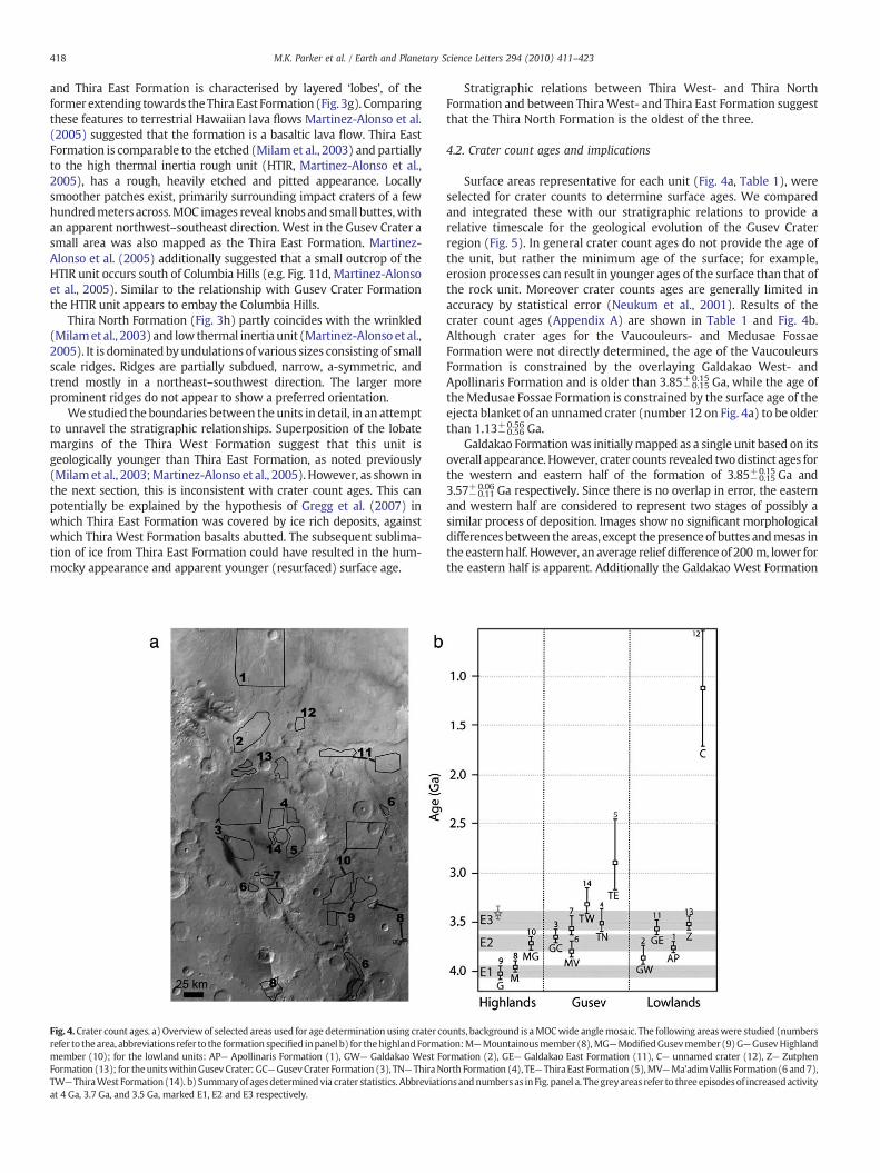
Fig. 4.Crater count ages. a) Overviewof selected areas used for age determination using crater corefer to the area, abbreviations refer to the formation specified inpanel b) for thehighlandFormamember (10); for the lowland units: AP— Apollinaris Formation (1), GW— Galdakao West FoFormation (13); for theunitswithinGusev Crater: GC—GusevCrater Formation (3), TN— ThiraNTW— ThiraWest Formation (14). b) Summaryof agesdeterminedvia crater statistics. Abbreviatioat 4 Ga, 3.7 Ga, and 3.5 Ga, marked E1, E2 and E3 respectively.
Stratigraphic relations between Thira West- and Thira NorthFormation and between ThiraWest- and Thira East Formation suggestthat the Thira North Formation is the oldest of the three.
4.2. Crater count ages and implications
Surface areas representative for each unit (Fig. 4a, Table 1), wereselected for crater counts to determine surface ages. We comparedand integrated these with our stratigraphic relations to provide arelative timescale for the geological evolution of the Gusev Craterregion (Fig. 5). In general crater count ages do not provide the age ofthe unit, but rather the minimum age of the surface; for example,erosion processes can result in younger ages of the surface than that ofthe rock unit. Moreover crater counts ages are generally limited inaccuracy by statistical error (Neukum et al., 2001). Results of thecrater count ages (Appendix A) are shown in Table 1 and Fig. 4b.Although crater ages for the Vaucouleurs- and Medusae FossaeFormation were not directly determined, the age of the VaucouleursFormation is constrained by the overlaying Galdakao West- andApollinaris Formation and is older than 3.85−0.15
+0.15 Ga, while the age oftheMedusae Fossae Formation is constrained by the surface age of theejecta blanket of an unnamed crater (number 12 on Fig. 4a) to be olderthan 1.13−0.56
+0.56 Ga.Galdakao Formationwas initiallymapped as a single unit based on its
overall appearance. However, crater counts revealed twodistinct ages forthe western and eastern half of the formation of 3.85−0.15
+0.15 Ga and3.57−0.11
+0.06 Ga respectively. Since there is no overlap in error, the easternand western half are considered to represent two stages of possibly asimilar process of deposition. Images show no significant morphologicaldifferencesbetween theareas, except thepresenceof buttes andmesas inthe easternhalf. However, an average relief difference of 200 m, lower forthe eastern half is apparent. Additionally the Galdakao West Formation
unts, background is aMOCwide anglemosaic. The following areaswere studied (numberstion:M—Mountainousmember(8),MG—ModifiedGusevmember(9)G—GusevHighlandrmation (2), GE— Galdakao East Formation (11), C— unnamed crater (12), Z— Zutphenorth Formation (4), TE— ThiraEast Formation (5),MV—Ma'adimVallis Formation (6 and7),nsandnumbersas inFig. panel a. Thegreyareas refer to three episodesof increasedactivity
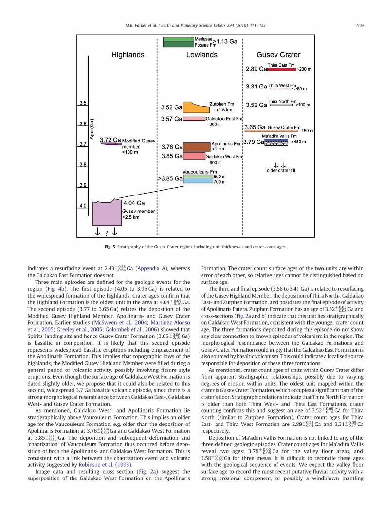
Fig. 5. Stratigraphy of the Gusev Crater region, including unit thicknesses and crater count ages.
419M.K. Parker et al. / Earth and Planetary Science Letters 294 (2010) 411–423
indicates a resurfacing event at 2.43−0.64+0.58 Ga (Appendix A), whereas
the Galdakao East Formation does not.Three main episodes are defined for the geologic events for the
region (Fig. 4b). The first episode (4.05 to 3.95 Ga) is related tothe widespread formation of the highlands. Crater ages confirm thatthe Highland Formation is the oldest unit in the area at 4.04−0.10
+0.06 Ga.The second episode (3.77 to 3.65 Ga) relates the deposition of theModified Gusev Highland Member, Apollinaris- and Gusev CraterFormation. Earlier studies (McSween et al., 2004; Martinez-Alonsoet al., 2005; Greeley et al., 2005; Golombek et al., 2006) showed thatSpirits' landing site and hence Gusev Crater Formation (3.65−0.10
+0.06 Ga)is basaltic in composition. It is likely that this second episoderepresents widespread basaltic eruptions including emplacement ofthe Apollinaris Formation. This implies that topographic lows of thehighlands, the Modified Gusev Highland Member were filled during ageneral period of volcanic activity, possibly involving fissure styleeruptions. Even though the surface age of GaldakaoWest Formation isdated slightly older, we propose that it could also be related to thissecond, widespread 3.7 Ga basaltic volcanic episode, since there is astrong morphological resemblance between Galdakao East-, GaldakaoWest- and Gusev Crater Formation.
As mentioned, Galdakao West- and Apollinaris Formation liestratigraphically above Vaucouleurs Formation. This implies an olderage for the Vaucouleurs Formation, e.g. older than the deposition ofApollinaris Formation at 3.76−0.06
+0.04 Ga and Galdakao West Formationat 3.85−0.15
+0.15 Ga. The deposition and subsequent deformation and‘chaotization’ of Vaucouleurs Formation thus occurred before depo-sition of both the Apollinaris- and Galdakao West Formation. This isconsistent with a link between the chaotization event and volcanicactivity suggested by Robinson et al. (1993).
Image data and resulting cross-section (Fig. 2a) suggest thesuperposition of the Galdakao West Formation on the Apollinaris
Formation. The crater count surface ages of the two units are withinerror of each other, so relative ages cannot be distinguished based onsurface age.
The third and final episode (3.58 to 3.41 Ga) is related to resurfacingof theGusevHighlandMember, thedepositionof ThiraNorth-,GaldakaoEast- and Zutphen Formation, and postdates the final episode of activityof Apollinaris Patera. Zutphen Formation has an age of 3.52−0.08
+0.05 Ga andcross-sections (Fig. 2a and b) indicate that this unit lies stratigraphicallyon GaldakaoWest Formation, consistent with the younger crater countage. The three formations deposited during this episode do not showany clear connection to known episodes of volcanism in the region. Themorphological resemblance between the Galdakao Formations andGusev Crater Formation could imply that theGaldakao East Formation isalso sourced by basaltic volcanism. This could indicate a localised sourceresponsible for deposition of these three formations.
As mentioned, crater count ages of units within Gusev Crater differfrom apparent stratigraphic relationships, possibly due to varyingdegrees of erosion within units. The oldest unit mapped within thecrater is Gusev Crater Formation,which occupies a significant part of thecrater'sfloor. Stratigraphic relations indicate that ThiraNorth Formationis older than both Thira West- and Thira East Formations, cratercounting confirms this and suggest an age of 3.52−0.16
+0.08 Ga for ThiraNorth (similar to Zutphen Formation). Crater count ages for ThiraEast- and Thira West Formation are 2.89−0.44
+0.28 Ga and 3.31−0.17+0.09 Ga
respectively.Deposition of Ma'adim Vallis Formation is not linked to any of the
three defined geologic episodes. Crater count ages for Ma'adim Vallisreveal two ages: 3.79−0.08
+0.05 Ga for the valley floor areas, and3.58−0.10
+0.06 Ga for three mesas. It is difficult to reconcile these ageswith the geological sequence of events. We expect the valley floorsurface age to record the most recent putative fluvial activity with astrong erosional component, or possibly a windblown mantling

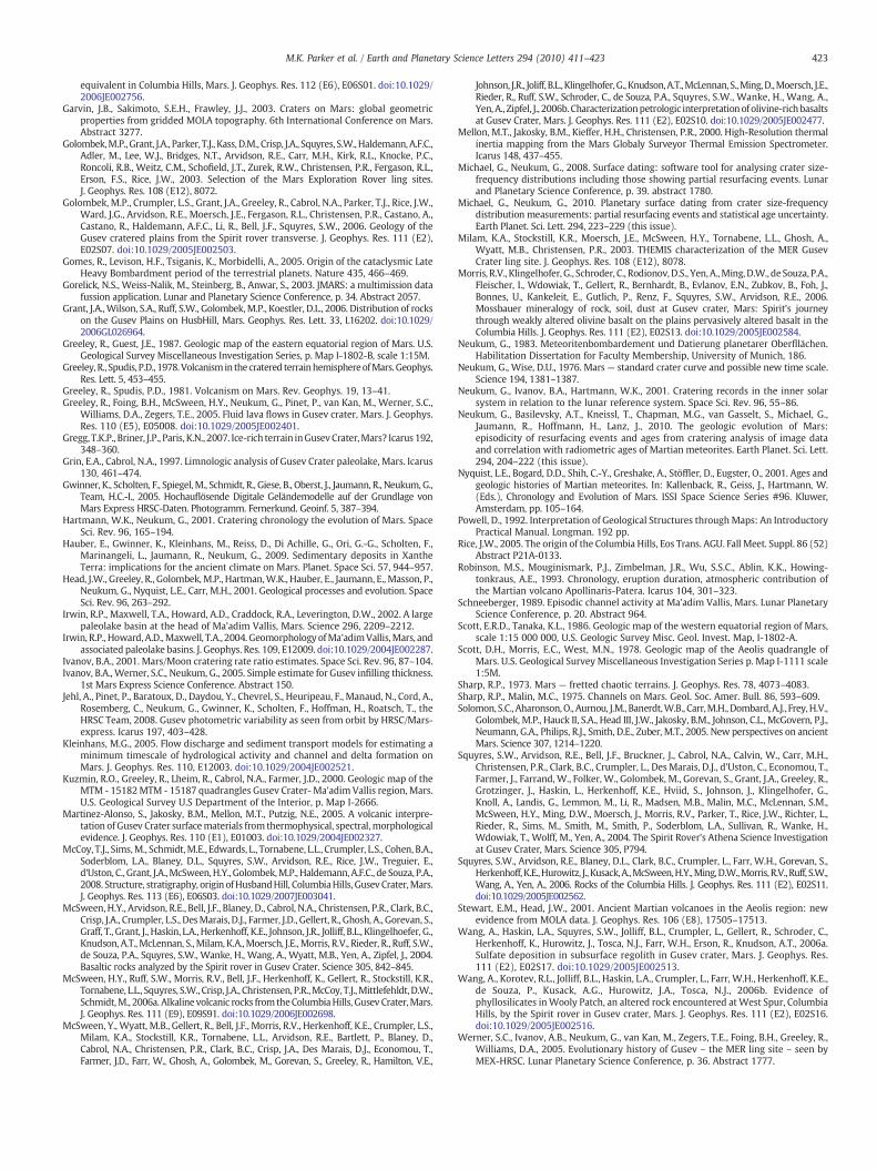
Table 2Selected Martian craters for comparison with Gusev Crater.
Crater name Lat. o* Long., oE* D,(km)*
Da,(km)**
Ha,(m)**
dSM** Ha, (m) for
filled craters
Green −52.7 351.6 184 170 1800 1200Molesworth −27.7 149.1 181Baldet 23 65.4 180 1800Terby −28.3 74.1 174 1240Flammarion 25.4 48.2 173 1500Wallace −52.9 110.6 173 1130Becquerel 22.3 352 171.2 1200Henry 10.9 23.3 171Proctor −48 29.5 168.2 700Gusev −14.7 175.4 166 150 1100Bakhuysen −23.3 15.6 161 150 2600 1400Schaeberle −24.7 50.1 160 700Janssen 2.7 37.5 158 1400Lohse (Fig. 6a) −43 343 156 150 2800 1500Holden −26.4 326 153.8 150 2400 1300Lomonosov 65.2 350.8 153 110 1900 1500Hale −36.1 323.5 149 130 2800 1300Quenisset 34.3 40.6 138 125 1500 900Moreux 41.8 44.4 138 120 2200 400Liu_Hsin −53.3 188.4 137 130 1800 −500Cerulli 32.2 22.1 130 110 2800 1400Maraldi −62 328 124 120 2100 1500Milankovivc 54.7 213.4 118 110 1800 1000Fournier −4.3 72.6 118 105 1700 1000Wright −58.6 209 115 110 1200 −400Perepelkin 52.5 295.4 112 80 1700 700Mie 48.1 139.6 104 100 1400 1000Du Martheray(Fig. 6b)
5.5 93.5 102 90 2100 500
*Latitude, longitude and rim crater diameter are according to JMars-related databases.**Apparent diameter Da, depth Ha, and depth of the central mound summit dSM aremeasured in respect to estimated pre-impact surface. Due to rough surface depthestimates seems to have error bars of the order of ±100 m.
420 M.K. Parker et al. / Earth and Planetary Science Letters 294 (2010) 411–423
deposit whereas the mesas may represent an older unit, deposited atthe outlet of Ma'adim Vallis, potentially a fan or delta deposit thatformed quickly, during an earlier or possibly during the final stage offluvial activity. This contradicts with the surface ages. Since the mesashave a positive topography with respect to the floor of Gusev Craterand Ma'adim Vallis, we consider it likely that the mesas sufferedconsiderable erosion, such that the crater count age of the surfacedoes not necessarily reflect the actual age of the unit implying that themesas could be ≥3.79 Ga.
5. Discussion
The geologic map and geological analysis based on the cross-sections and crater ages are in general agreement with earlier studies,based on Viking (Kuzmin et al., 2000) and THEMIS (Milam et al., 2003;Martinez-Alonso et al., 2005) data. However, in a number of areas theapproach used here provides new insights into the geologic evolutionof the Gusev Crater region. The new insights that we gained areprimarily derived from our 3D structural geological analysis. Com-bining the geologic mapping and cross-sections we now have a strongconstraint on superposition relations of many of the mapped units, aswell as thickness estimates. The crater count surface ages serve tobracket the timeframe during which deposition and surface modifi-cation of units took place. From this combination of 3D geologicalinformation and age estimates we derived a detailed sequence ofevents for the region.
5.1. Sequence of geologic events
The main activity within the Gusev Crater region was restricted tothree episodes at >4 Ga, 3.7 Ga, and 3.5 Ga (Fig. 4b). The highlandunit is the oldest recognised unit with a surface age of ∼4 Ga. In detail(and beyond the scope of this paper), the highlands show a complexgeology, in which several sub-units can be distinguished. The high-lands also show abundant erosional features, attesting to a moredynamic surface environment in the period prior to 4 Ga. The 4 Gasurface age is in the case of the highlands clearly a younger, lowerlimit, to the actual ages of the geological units making up the highlandterrain, which is at least 2.5 km thick.
The lowland units were mostly deposited during the 3.7 and 3.5 Gaepisodes, with the youngest unit being the Medusae Fossae Formation.At least parts of the lowland deposits (e.g. Gusev Crater- and GaldakaoFormation), are likely linked to Apollinaris Patera volcanism at ∼3.7 Ga.The Vaucouleurs Formation has a minimum age constraint imposed bydeposition of Galdakao West- and Apollinaris Formation of 3.8 Ga. Themost likely scenario is that the original deposition of units in theVaucouleurs Crater was coeval to part of the formation of the Highlandterrain at >4 Ga. The break-up of these units into the present chaoticterrain occurred prior to, or during the 3.7 Ga event. The chaotizationeventmay have been related to the same thermal event that resulted inthe 3.7 Ga volcanism. Considering the ages of the Apollinaris Pateravolcanics, Apollinaris- (3.76−0.06
+0.04 Ga) and Galdakao West Formation(3.85−0.15
+0.15 Ga) it is possible that Galdakao West Formation representsvolcanic material from an earlier stage of Apollinaris Patera.
The Zutphen Formation occupies the northern rim of the GusevCrater. It is as thick as 1.5 km and is hence a significant deposition at3.52−0.08
+0.05 Ga. As noted in the previous section its deposition could berelated to Thira North Formation at 3.52−0.16
+0.08 Ga. However there doesnot seem to be any direct morphological similarities between the twoformations. The grooves and channels characterising the surface of theZutphen Formation must have formed after deposition, e.g. later than3.52−0.08
+0.05 Ga.A comparison of Gusev Crater with similar sized ‘fresh’, unfilled
craters, follows in the next section, suggesting that the original level ofGusev Crater floor could have been in the order of 1500 m deeper thanthe current level. Gusev Crater Formation is estimated to be minimum
150 m thick and thus probably does not fully account for the fillsequence. The original crater basin must have been filled initially byimpact relatedmaterials, such as an impact melt sheet, impactites andsubsequently by putative sediments fromMa'adim Vallis, which couldin fact account for a fair amount, up to 1 km (Hauber et al., 2009). Theminimum thickness of 450 m estimated for Ma'adim Vallis Formationis based on the height of the mesas, and could thus be significantlythicker. Crater count statistics of the mesas indicate a final stage offluvial activity at 3.58−0.10
+0.06 Ga relating to the formation of the mesas.We argue that this cannot have been the case, since the formation ofthe mesas requires vast amounts of material to be released insideGusev Crater. We expect that the mesa crater count age is in fact anerosional age, particularly considering that the Gusev Crater Forma-tion, which embays the mesas, is apparently older (3.65 Ga). Theother formations present within the crater are, based on craterstatistics, all dated younger than the widespread Gusev CraterFormation, 3.65−0.10
+0.06 Ga. The Columbia Hills are too small for cratercounting, but stratigraphic relationships suggest that an angularunconformity exists with the surrounding units embaying ColumbiaHills.
5.2. Geometry of the Gusev Crater
The geometry of Gusev Crater is particularly interesting since thecraters' size suggests that it should be a complex impact crater. How-ever, a central uplifted region has not been identified. A logical questionthat follows is: Has subsequent volcanism and perhaps sedimentationcovered and obscured the craters' central uplift?
The Gusev Crater has a rim-to-rim diameter of ∼160 km and floorto floor diameter of ∼120 km. A number of impact craters with rimdiameters 100<D<180 km (Table 2) were selected to serve as a

421M.K. Parker et al. / Earth and Planetary Science Letters 294 (2010) 411–423
comparison to the Gusev Crater. Some of these craters, includingGusev, have relatively flat floors apparently due to infilling by post-impact sediments and/or volcanic materials. The apparent depth of
Fig. 6. Comparison of Gusev Crater and pristine craters of similar size. a) Two topographic prfor SW–NE direction). Black line shows an approximated pre-impact surface in N–S directionsummit and outside the Du Martheray crater demonstrates that in an oblique surface (∼140below (∼1 km) the highest rim portion. c) Two profiles through Gusev Crater (NW–SE— solidNW–SE direction. With respect to the more level SW–NE direction, the flat floor depth is aboabove the floor while in the SE portion the rim elevation is about 2600 m above the floor. d)smaller 100 km in diameter a set of analytic relations is published for rim-crest diameters D ais after Boyce and Garbeil (2007) who measured most pristine craters. Authors' selected datawith D>200 km) are obtained with estimation of the pre-impact surface position and presenwith the curve Ha(m)=350⁎Da
0.44 which gives us the best available estimate for the apparenvs. Depth (Ha). Note that vertical axis is directed downward. Black dots with error bars showUpward triangles show apparent depths for craters in Table 2. Downward triangles show apThese points present the “upper limit” to the dSM. Black star is for Gusev average apparent ddashed line. The solid curve is a fragment of Ha(Da) relationship shown in panel d). f) Sketchthe Gusev central mound geometry. The top of the original central mound is just visible ab
the flat floor of these craters is listed in the last column of Table 2. Asecond group of craters, also partially filled with post-impactsediments and/or volcanic materials does have a relatively distinct
ofiles trough the centre of Lohse crater (solid curve is for N–S direction, dashed curve is. The central uplift region is clearly visible. b) A set of NW–SE profiles trough the central0 m per 100 km) the central mound may be at the level of lowest rim portion but wellcurve, SW–NE— dashed curve) show an apparent gradient ∼1100 m per 100 km in the
ut 1100 m below the pre-impact surface. The crater rim elevation in NW area is ∼600 mDepth–diameter relations for Martian impact craters in log–log coordinates. For cratersnd the depth below the rim crest H: dotted line is after Garvin et al. (2003), dashed line(circles for small craters, downward triangles for large craters and diamonds for basinst “apparent” depth and diameters. Craters with largest apparent depth can be “covered”t depth of “pristine” craters. e) Linear plot of data in Table 2 of apparent diameter (Da)the summit of the central mound position below the assumed pre-impact surface, dSM.parent depth for heavily filled craters in Table 2 where no central mounds are visible.epth of 1100 m (see panel c for details), the same level is outlined with the horizontalof suggested situation for Gusev Crater in cross-section, based on the above estimate forove the infill of Gusev Crater and thought to represent Columbia Hills.
422 M.K. Parker et al. / Earth and Planetary Science Letters 294 (2010) 411–423
central mound rising above the crater floor. For this latter group the“apparent depth” and “depth of the central mound summit (dSM)”were measured in respect to the estimated pre-impact surface. Theseare measured using topographic profiles across various craters onMars combined with JMars software (Fig. 6a). We assume that thevisible central mound in our selection of craters is the remnant of thereal central mound, formed during collapse of the central cavity.
In many cases pre-impact surface topography is variable, withtopographic slopes up to 1000–2000 m per 100 km (Fig. 6b), which iscomparable with the final crater depth. Gusev Crater belongs to thissubsample (Fig. 6c). The average depth is ∼ 1 km, but rim elevationsrange up to 3 km.
The data are summarised in Fig. 6d and e. Fig. 6d shows apparentdepths of measured craters in the context of other published depth–diameter relations (mostly for rim-crest diameters and the depth belowthe rim-crest level). Fig. 6e shows data for apparent crater depths andcentral summit position for craters in Table 2. For craterswithdiametersfrom 100 to 180 km there is no evident trend in dSM(Da) dependence:the cloud of dSM dots occupy the area of dSM≥1500 m.
Comparison of Gusev Crater with these similar sized craters(Table 2) shows that some of the craters do show central uplifts,whereas others, including Gusev, do not. The lack of central uplifts isapparently due to infilling by post-impact materials and peak erosionover time. A few craters have their central peak rising above the pre-impact surface level. Three craters with apparent diameters of∼150 km similar to Gusev Crater have central peak summits justbelow the apparent depth of Gusev Crater of 1100 m.
Taking into account (a) the natural scatter of dSM values and (b) thespecific of the central mound position in a rough or oblique-surfaceterrains (like in Fig. 6b) we should not exclude the possibility that themodern level of Gusev's visible floor is close to the central peak summitposition. The Columbia Hills could be a remnant of the pristine centraluplift and/or early deposits covering the structural uplift (Fig. 6f). This isconsistent with findings of McCoy et al. (2008) who analysed the 3Dgeometry of the Columbia Hills by using dips measured by MER Spirit.Other hypothesis for the origin of Columbia Hills include erosionalremnant of layered material, volcanic construct, or a tectonic wrinkleridge (Rice, 2005) appear less likely. Additionally compositional analysisby Spirit, showing that rocks within Columbia hills are highly phos-phorous and hydrothermally altered (e.g. Squyres et al., 2006) agreewith the expectations for centrally uplifted regions of complex impactcraters.
5.3. Gusev Crater regional events in the global context
From a variety of sources of information it is clear that the geo-logically most active period in Mars history was the Noachian andearly Hesperian (Head et al., 2001; Solomon et al., 2005 and refer-ences therein; Bibring et al., 2006). The Gusev Crater region is noexception, with deposition of all units, except the Medussae FossaeFormation, prior to 3.5 Ga. Mineralogical evidence, in the form ofphyllosilicates, morphological evidence and evidence from the onlyNoachian Martian meteorite, Allan Hills 84001 (Nyquist et al., 2001),all suggest interaction of the Martian crust with liquid water in theperiod prior to 4 Ga. This is consistent with formation of the highlandterrains in the Gusev Crater region in a geologically most active and‘wet’ period, involving relatively high erosion rates.
The impact that formed Gusev Crater must have taken place after4.0 Ga (lower limit of the Highland Formation) and before 3.8 Ga(onset of deposition of units within Gusev Crater), coinciding with thewaning stages of the Late Heavy Bombardment event (e.g. Gomeset al., 2005).
Most of deposition in Gusev Crater, with an estimated thickness of1500 m, must have taken place prior to the emplacement of the GusevCrater Formation at 3.65 Ga. Gusev basin fill may include sedimentstransported by Ma'adim Vallis' and volcanic sequences perhaps
associated with Apollinaris Patera. Globally, this period is charac-terised by magmatic events associated with the build-up of Tharsisand smaller volcanic edifices, such as Apollinaris Patera. Activity ofoutflow channels appear to follow the major volcanic events(Neukum et al., 2010-this issue) and this also appears to be the casefor the Gusev Crater region.
According to our geometric analysis the Columbia Hills couldrepresent a relict of the original central uplift of Gusev Crater. Thiswould imply that the rock units analysed by the MER rover wereformed prior to the impact that created Gusev Crater, and have beenheavily deformed and altered during and directly after the impactevent (McCoy et al., 2008).
Bibring et al. (2006) proposed an association of the ∼3.7 Gavolcanic event with deposition of sulphate deposits, typically found inlight toned layered sequences. In the Gusev Crater region we have noindication for the presence of sulphate bearing deposits in the unitsformed at ∼3.7 Ga. However, detailed studies of hyperspectral datausing OMEGA or CRISM data sets have not been carried out.
In the Gusev Crater and on the northern rim we find unitsdeposited at ∼3.5 Ga. Those units appear to post-date the majorvolcanic event at ∼3.7 Ga. The most voluminous of those units is theZutphen unit, with a thickness up to 1.5 km. It is not clear what thecomposition and depositional process of these deposits is.
6. Conclusions
The main activity within the Gusev Crater region is restricted tothree episodes at >4 Ga, 3.7 Ga and 3.5 Ga. The record of geologicalevents in the Gusev Crater region can be linked to global Martianevents and place additional time constraints on such events. Thegeometry of the Gusev Crater as compared to similar sized Martiancraters could indicate that the Columbia Hills represent a relic of thecentral uplift of the crater.
Acknowledgements
We like to thank the HRSC CO-I team for providing the DEM's. Wewould like to thank Sara Martinez-Alonso and an anonymousreviewer for their comments and suggestions, which significantlyimproved the manuscript. We also would like to thank S. Parker,J. Chadwick, R. Greeley andM. Kleinhans for providing useful commentsto the manuscript.
Appendix A. Supplementary data
Supplementary data associated with this article can be found, inthe online version, at doi:10.1016/j.epsl.2010.01.013.
References
Bibring, J.P., Langevin, Y., Mustard, J.F., Poulet, F., Arvidson, R., Gendrin, A., Gondet, B.,Mangold, N., Pinet, P., Forget, F., the OMEGA team, 2006. Global mineralogical andaqueousMars history derived fromOMEGA/Mars Express data. Science 312, 400–404.
Boyce, J.M., Garbeil, H., 2007. Geometric relationships of pristine Martian complex impactcraters, their implications to Mars geologic history. Geophys. Res. Lett. 34, 16.
Bradley, B.A., Sakimoto, S.E.H., Frey, H., Zibelman, J.R., 2002. Medusae Fossae Formation:new perspectives from Mars Global Surveyor. J. Geophys. Res. 107 (E8), 5058.
Cabrol, N.A., Grin, E.A., Lheim, R., Kuzmin, R.O., Greeley, R., 1998. Duration of the Ma'adimVallis/Gusev Crater hydrogeologic system, Mars. Icarus 133, 98–108.
Cabrol, N.A., Grin, E.A., Carr, M.H., Sutter, B., Moore, J.M., Farmer, J.D., Greeley, R.,Kuzmin, R.O., DesMarais, D.J., Kramer, M.G., Newsom, H., Barber, C., Thorsos, I.,Tanaka, K.L., Barlow, N.G., Fike, D.A., Urquhart, M.L., Grigsby, B., Grant, F.D., deGoursac, O., 2003. Exploring Gusev Crater with Spirit: review of science objectivestestable hypotheses. J. Geophys. Res. 108 (E12), 8076.
Carter, L.M., Campbell, B.A., Watters, T.R., Phillips, R.J., Putzig, N.E., Safaeinili, A., Plaut, J.J.,Okubo, C.H., Egan, A.F., Seu, R., Biccari, D., Orosei, R., 2009. Shallow radar (SHARAD)sounding observations of the Medusae Fossae Formation, Mars. Icarus 199, 295–302.
Clark, B.C., Arvidson, R.E., Gellert, R., Morris, R.V., Ming, D.W., Richter, L., Ruff, S.W.,Michalski, J.R., Farr, W.H., Yen, A., Herkenhoff, K.E., Li, R., Squyres, S.W., Schroder, C.,Klingelhofer, G., Bell, J.F., 2007. Evidence for montmorillonite or its compositional
423M.K. Parker et al. / Earth and Planetary Science Letters 294 (2010) 411–423
equivalent in Columbia Hills, Mars. J. Geophys. Res. 112 (E6), E06S01. doi:10.1029/2006JE002756.
Garvin, J.B., Sakimoto, S.E.H., Frawley, J.J., 2003. Craters on Mars: global geometricproperties from gridded MOLA topography. 6th International Conference on Mars.Abstract 3277.
Golombek,M.P., Grant, J.A., Parker, T.J., Kass,D.M., Crisp, J.A., Squyres, S.W.,Haldemann,A.F.C.,Adler, M., Lee, W.J., Bridges, N.T., Arvidson, R.E., Carr, M.H., Kirk, R.L., Knocke, P.C.,Roncoli, R.B., Weitz, C.M., Schofield, J.T., Zurek, R.W., Christensen, P.R., Fergason, R.L.,Erson, F.S., Rice, J.W., 2003. Selection of the Mars Exploration Rover ling sites.J. Geophys. Res. 108 (E12), 8072.
Golombek, M.P., Crumpler, L.S., Grant, J.A., Greeley, R., Cabrol, N.A., Parker, T.J., Rice, J.W.,Ward, J.G., Arvidson, R.E., Moersch, J.E., Fergason, R.L., Christensen, P.R., Castano, A.,Castano, R., Haldemann, A.F.C., Li, R., Bell, J.F., Squyres, S.W., 2006. Geology of theGusev cratered plains from the Spirit rover transverse. J. Geophys. Res. 111 (E2),E02S07. doi:10.1029/2005JE002503.
Gomes, R., Levison, H.F., Tsiganis, K., Morbidelli, A., 2005. Origin of the cataclysmic LateHeavy Bombardment period of the terrestrial planets. Nature 435, 466–469.
Gorelick, N.S., Weiss-Nalik, M., Steinberg, B., Anwar, S., 2003. JMARS: a multimission datafussion application. Lunar and Planetary Science Conference, p. 34. Abstract 2057.
Grant, J.A., Wilson, S.A., Ruff, S.W., Golombek,M.P., Koestler, D.L., 2006. Distribution of rockson the Gusev Plains on HusbHill, Mars. Geophys. Res. Lett. 33, L16202. doi:10.1029/2006GL026964.
Greeley, R., Guest, J.E., 1987. Geologic map of the eastern equatorial region of Mars. U.S.Geological Survey Miscellaneous Investigation Series, p. Map I-1802-B, scale 1:15M.
Greeley, R., Spudis, P.D., 1978.Volcanism in thecratered terrainhemisphereofMars.Geophys.Res. Lett. 5, 453–455.
Greeley, R., Spudis, P.D., 1981. Volcanism on Mars. Rev. Geophys. 19, 13–41.Greeley, R., Foing, B.H., McSween, H.Y., Neukum, G., Pinet, P., van Kan, M., Werner, S.C.,
Williams, D.A., Zegers, T.E., 2005. Fluid lava flows in Gusev crater, Mars. J. Geophys.Res. 110 (E5), E05008. doi:10.1029/2005JE002401.
Gregg, T.K.P., Briner, J.P., Paris, K.N., 2007. Ice-rich terrain inGusevCrater,Mars? Icarus 192,348–360.
Grin, E.A., Cabrol, N.A., 1997. Limnologic analysis of Gusev Crater paleolake, Mars. Icarus130, 461–474.
Gwinner, K., Scholten, F., Spiegel,M., Schmidt, R., Giese, B., Oberst, J., Jaumann, R., Neukum, G.,Team, H.C.-I., 2005. Hochauflösende Digitale Geländemodelle auf der Grundlage vonMars Express HRSC-Daten. Photogramm. Fernerkund. Geoinf. 5, 387–394.
Hartmann, W.K., Neukum, G., 2001. Cratering chronology the evolution of Mars. SpaceSci. Rev. 96, 165–194.
Hauber, E., Gwinner, K., Kleinhans, M., Reiss, D., Di Achille, G., Ori, G.-G., Scholten, F.,Marinangeli, L., Jaumann, R., Neukum, G., 2009. Sedimentary deposits in XantheTerra: implications for the ancient climate on Mars. Planet. Space Sci. 57, 944–957.
Head, J.W., Greeley, R., Golombek,M.P., Hartman,W.K., Hauber, E., Jaumann, E., Masson, P.,Neukum, G., Nyquist, L.E., Carr, M.H., 2001. Geological processes and evolution. SpaceSci. Rev. 96, 263–292.
Irwin, R.P., Maxwell, T.A., Howard, A.D., Craddock, R.A., Leverington, D.W., 2002. A largepaleolake basin at the head of Ma'adim Vallis, Mars. Science 296, 2209–2212.
Irwin, R.P., Howard,A.D.,Maxwell, T.A., 2004. Geomorphology ofMa'adimVallis,Mars, andassociated paleolake basins. J. Geophys. Res. 109, E12009. doi:10.1029/2004JE002287.
Ivanov, B.A., 2001. Mars/Moon cratering rate ratio estimates. Space Sci. Rev. 96, 87–104.Ivanov, B.A., Werner, S.C., Neukum, G., 2005. Simple estimate for Gusev infilling thickness.
1st Mars Express Science Conference. Abstract 150.Jehl, A., Pinet, P., Baratoux, D., Daydou, Y., Chevrel, S., Heuripeau, F., Manaud, N., Cord, A.,
Rosemberg, C., Neukum, G., Gwinner, K., Scholten, F., Hoffman, H., Roatsch, T., theHRSC Team, 2008. Gusev photometric variability as seen from orbit by HRSC/Mars-express. Icarus 197, 403–428.
Kleinhans, M.G., 2005. Flow discharge and sediment transport models for estimating aminimum timescale of hydrological activity and channel and delta formation onMars. J. Geophys. Res. 110, E12003. doi:10.1029/2004JE002521.
Kuzmin, R.O., Greeley, R., Lheim, R., Cabrol, N.A., Farmer, J.D., 2000. Geologic map of theMTM - 15182MTM - 15187 quadrangles Gusev Crater-Ma'adim Vallis region, Mars.U.S. Geological Survey U.S Department of the Interior, p. Map I-2666.
Martinez-Alonso, S., Jakosky, B.M., Mellon, M.T., Putzig, N.E., 2005. A volcanic interpre-tation of Gusev Crater surfacematerials from thermophysical, spectral,morphologicalevidence. J. Geophys. Res. 110 (E1), E01003. doi:10.1029/2004JE002327.
McCoy, T.J., Sims,M., Schmidt,M.E., Edwards, L., Tornabene, L.L., Crumpler, L.S., Cohen, B.A.,Soderblom, L.A., Blaney, D.L., Squyres, S.W., Arvidson, R.E., Rice, J.W., Treguier, E.,d'Uston, C., Grant, J.A.,McSween,H.Y., Golombek,M.P., Haldemann, A.F.C., de Souza, P.A.,2008. Structure, stratigraphy, origin ofHusbandHill, ColumbiaHills, GusevCrater,Mars.J. Geophys. Res. 113 (E6), E06S03. doi:10.1029/2007JE003041.
McSween, H.Y., Arvidson, R.E., Bell, J.F., Blaney, D., Cabrol, N.A., Christensen, P.R., Clark, B.C.,Crisp, J.A., Crumpler, L.S., DesMarais, D.J., Farmer, J.D., Gellert, R., Ghosh, A., Gorevan, S.,Graff, T., Grant, J., Haskin, L.A., Herkenhoff, K.E., Johnson, J.R., Jolliff, B.L., Klingelhoefer, G.,Knudson, A.T.,McLennan, S.,Milam, K.A.,Moersch, J.E.,Morris, R.V., Rieder, R., Ruff, S.W.,de Souza, P.A., Squyres, S.W., Wanke, H., Wang, A., Wyatt, M.B., Yen, A., Zipfel, J., 2004.Basaltic rocks analyzed by the Spirit rover in Gusev Crater. Science 305, 842–845.
McSween, H.Y., Ruff, S.W., Morris, R.V., Bell, J.F., Herkenhoff, K., Gellert, R., Stockstill, K.R.,Tornabene, L.L., Squyres, S.W.,Crisp, J.A., Christensen, P.R.,McCoy,T.J.,Mittlefehldt,D.W.,Schmidt,M., 2006a. Alkaline volcanic rocks from theColumbiaHills, Gusev Crater,Mars.J. Geophys. Res. 111 (E9), E09S91. doi:10.1029/2006JE002698.
McSween, Y., Wyatt, M.B., Gellert, R., Bell, J.F., Morris, R.V., Herkenhoff, K.E., Crumpler, L.S.,Milam, K.A., Stockstill, K.R., Tornabene, L.L., Arvidson, R.E., Bartlett, P., Blaney, D.,Cabrol, N.A., Christensen, P.R., Clark, B.C., Crisp, J.A., Des Marais, D.J., Economou, T.,Farmer, J.D., Farr, W., Ghosh, A., Golombek, M., Gorevan, S., Greeley, R., Hamilton, V.E.,
Johnson, J.R., Joliff, B.L.,Klingelhofer,G., Knudson,A.T.,McLennan, S.,Ming,D.,Moersch, J.E.,Rieder, R., Ruff, S.W., Schroder, C., de Souza, P.A., Squyres, S.W., Wanke, H., Wang, A.,Yen,A., Zipfel, J., 2006b. Characterizationpetrologic interpretationof olivine-richbasaltsat Gusev Crater, Mars. J. Geophys. Res. 111 (E2), E02S10. doi:10.1029/2005JE002477.
Mellon, M.T., Jakosky, B.M., Kieffer, H.H., Christensen, P.R., 2000. High-Resolution thermalinertia mapping from the Mars Globaly Surveyor Thermal Emission Spectrometer.Icarus 148, 437–455.
Michael, G., Neukum, G., 2008. Surface dating: software tool for analysing crater size-frequency distributions including those showing partial resurfacing events. Lunarand Planetary Science Conference, p. 39. abstract 1780.
Michael, G., Neukum, G., 2010. Planetary surface dating from crater size-frequencydistribution measurements: partial resurfacing events and statistical age uncertainty.Earth Planet. Sci. Lett. 294, 223–229 (this issue).
Milam, K.A., Stockstill, K.R., Moersch, J.E., McSween, H.Y., Tornabene, L.L., Ghosh, A.,Wyatt, M.B., Christensen, P.R., 2003. THEMIS characterization of the MER GusevCrater ling site. J. Geophys. Res. 108 (E12), 8078.
Morris, R.V., Klingelhofer, G., Schroder, C., Rodionov,D.S., Yen,A.,Ming,D.W., deSouza, P.A.,Fleischer, I., Wdowiak, T., Gellert, R., Bernhardt, B., Evlanov, E.N., Zubkov, B., Foh, J.,Bonnes, U., Kankeleit, E., Gutlich, P., Renz, F., Squyres, S.W., Arvidson, R.E., 2006.Mossbauer mineralogy of rock, soil, dust at Gusev crater, Mars: Spirit's journeythrough weakly altered olivine basalt on the plains pervasively altered basalt in theColumbia Hills. J. Geophys. Res. 111 (E2), E02S13. doi:10.1029/2005JE002584.
Neukum, G., 1983. Meteoritenbombardement und Datierung planetarer Oberfllächen.Habilitation Dissertation for Faculty Membership, University of Munich, 186.
Neukum, G., Wise, D.U., 1976. Mars — standard crater curve and possible new time scale.Science 194, 1381–1387.
Neukum, G., Ivanov, B.A., Hartmann, W.K., 2001. Cratering records in the inner solarsystem in relation to the lunar reference system. Space Sci. Rev. 96, 55–86.
Neukum, G., Basilevsky, A.T., Kneissl, T., Chapman, M.G., van Gasselt, S., Michael, G.,Jaumann, R., Hoffmann, H., Lanz, J., 2010. The geologic evolution of Mars:episodicity of resurfacing events and ages from cratering analysis of image dataand correlation with radiometric ages of Martian meteorites. Earth Planet. Sci. Lett.294, 204–222 (this issue).
Nyquist, L.E., Bogard, D.D., Shih, C.-Y., Greshake, A., Stöffler, D., Eugster, O., 2001. Ages andgeologic histories of Martian meteorites. In: Kallenback, R., Geiss, J., Hartmann, W.(Eds.), Chronology and Evolution of Mars. ISSI Space Science Series #96. Kluwer,Amsterdam, pp. 105–164.
Powell, D., 1992. Interpretation of Geological Structures throughMaps: An IntroductoryPractical Manual. Longman. 192 pp.
Rice, J.W., 2005. The origin of the Columbia Hills, Eos Trans. AGU. Fall Meet. Suppl. 86 (52)Abstract P21A-0133.
Robinson, M.S., Mouginismark, P.J., Zimbelman, J.R., Wu, S.S.C., Ablin, K.K., Howing-tonkraus, A.E., 1993. Chronology, eruption duration, atmospheric contribution ofthe Martian volcano Apollinaris-Patera. Icarus 104, 301–323.
Schneeberger, 1989. Episodic channel activity at Ma'adim Vallis, Mars. Lunar PlanetaryScience Conference, p. 20. Abstract 964.
Scott, E.R.D., Tanaka, K.L., 1986. Geologic map of the western equatorial region of Mars,scale 1:15 000 000, U.S. Geologic Survey Misc. Geol. Invest. Map, I-1802-A.
Scott, D.H., Morris, E.C., West, M.N., 1978. Geologic map of the Aeolis quadrangle ofMars. U.S. Geological Survey Miscellaneous Investigation Series p. Map I-1111 scale1:5M.
Sharp, R.P., 1973. Mars — fretted chaotic terrains. J. Geophys. Res. 78, 4073–4083.Sharp, R.P., Malin, M.C., 1975. Channels on Mars. Geol. Soc. Amer. Bull. 86, 593–609.Solomon, S.C., Aharonson,O., Aurnou, J.M., Banerdt,W.B., Carr,M.H.,Dombard,A.J., Frey,H.V.,
Golombek, M.P., Hauck II, S.A., Head III, J.W., Jakosky, B.M., Johnson, C.L., McGovern, P.J.,Neumann, G.A., Philips, R.J., Smith, D.E., Zuber, M.T., 2005. New perspectives on ancientMars. Science 307, 1214–1220.
Squyres, S.W., Arvidson, R.E., Bell, J.F., Bruckner, J., Cabrol, N.A., Calvin, W., Carr, M.H.,Christensen, P.R., Clark, B.C., Crumpler, L., Des Marais, D.J., d'Uston, C., Economou, T.,Farmer, J., Farrand, W., Folker, W., Golombek, M., Gorevan, S., Grant, J.A., Greeley, R.,Grotzinger, J., Haskin, L., Herkenhoff, K.E., Hviid, S., Johnson, J., Klingelhofer, G.,Knoll, A., Landis, G., Lemmon, M., Li, R., Madsen, M.B., Malin, M.C., McLennan, S.M.,McSween, H.Y., Ming, D.W., Moersch, J., Morris, R.V., Parker, T., Rice, J.W., Richter, L.,Rieder, R., Sims, M., Smith, M., Smith, P., Soderblom, L.A., Sullivan, R., Wanke, H.,Wdowiak, T., Wolff, M., Yen, A., 2004. The Spirit Rover's Athena Science Investigationat Gusev Crater, Mars. Science 305, P794.
Squyres, S.W., Arvidson, R.E., Blaney, D.L., Clark, B.C., Crumpler, L., Farr, W.H., Gorevan, S.,Herkenhoff,K.E.,Hurowitz, J., Kusack,A.,McSween,H.Y.,Ming,D.W.,Morris,R.V.,Ruff, S.W.,Wang, A., Yen, A., 2006. Rocks of the Columbia Hills. J. Geophys. Res. 111 (E2), E02S11.doi:10.1029/2005JE002562.
Stewart, E.M., Head, J.W., 2001. Ancient Martian volcanoes in the Aeolis region: newevidence from MOLA data. J. Geophys. Res. 106 (E8), 17505–17513.
Wang, A., Haskin, L.A., Squyres, S.W., Jolliff, B.L., Crumpler, L., Gellert, R., Schroder, C.,Herkenhoff, K., Hurowitz, J., Tosca, N.J., Farr, W.H., Erson, R., Knudson, A.T., 2006a.Sulfate deposition in subsurface regolith in Gusev crater, Mars. J. Geophys. Res.111 (E2), E02S17. doi:10.1029/2005JE002513.
Wang, A., Korotev, R.L., Jolliff, B.L., Haskin, L.A., Crumpler, L., Farr, W.H., Herkenhoff, K.E.,de Souza, P., Kusack, A.G., Hurowitz, J.A., Tosca, N.J., 2006b. Evidence ofphyllosilicates inWooly Patch, an altered rock encountered atWest Spur, ColumbiaHills, by the Spirit rover in Gusev crater, Mars. J. Geophys. Res. 111 (E2), E02S16.doi:10.1029/2005JE002516.
Werner, S.C., Ivanov, A.B., Neukum, G., van Kan, M., Zegers, T.E., Foing, B.H., Greeley, R.,Williams, D.A., 2005. Evolutionary history of Gusev – the MER ling site – seen byMEX-HRSC. Lunar Planetary Science Conference, p. 36. Abstract 1777.