3d visualization of well completions using adobe pdf
TRANSCRIPT

3D Visualization of Wells
Jerrod StutzmanGIS Professional, Devon EnergyNelson DobbsGIS Professional, Devon Energy

Overview: Well Completions Map
Web map solution needed for analyzing well completions data
Geocortex Essentials user interface
FME is used to provide datasets for the map and for creating on-demand 3D PDFs

Completions Web Map

FME Jobs Spatialize Data
FME is used to spatialize well surface locations, wellbores, and perforation zones
Perforation zones are created using min and max depth values and querying directional survey points within that range, then creating a line and buffering
FME Server runs these 3 jobs daily and reports results via email. These are not very interesting so are not in scope of this presentation

Wells with Wellbores + Perfs
“Interesting visual, but what would this look like in 3D?”

How to easily visualize in 3D?
3D geospatial viewer not available in GeocortexEssentials
Most 3D visualizers are “heavy” apps
How can we solve this?
FME + 3D PDF!

Web Map Demo
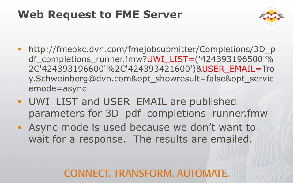
Web Request to FME Server
http://fmeokc.dvn.com/fmejobsubmitter/Completions/3D_pdf_completions_runner.fmw?UWI_LIST=('424393196500'%2C'424393196600'%2C'424393421600')&[email protected]&opt_showresult=false&opt_servicemode=async
UWI_LIST and USER_EMAIL are published parameters for 3D_pdf_completions_runner.fmw
Async mode is used because we don’t want to wait for a response. The results are emailed.

View From FME Server

3D GeoSpatial PDF

How Is This Achieved?
2 Workbenches were necessary when this was initially developed
Needed to calculate square bounding box parameters from the well list

3D PDF Creator Workbench

3D Borepath Details
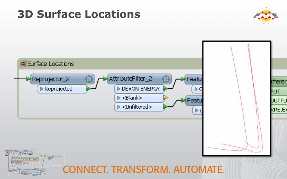
3D Surface Locations

3D Depth Markers
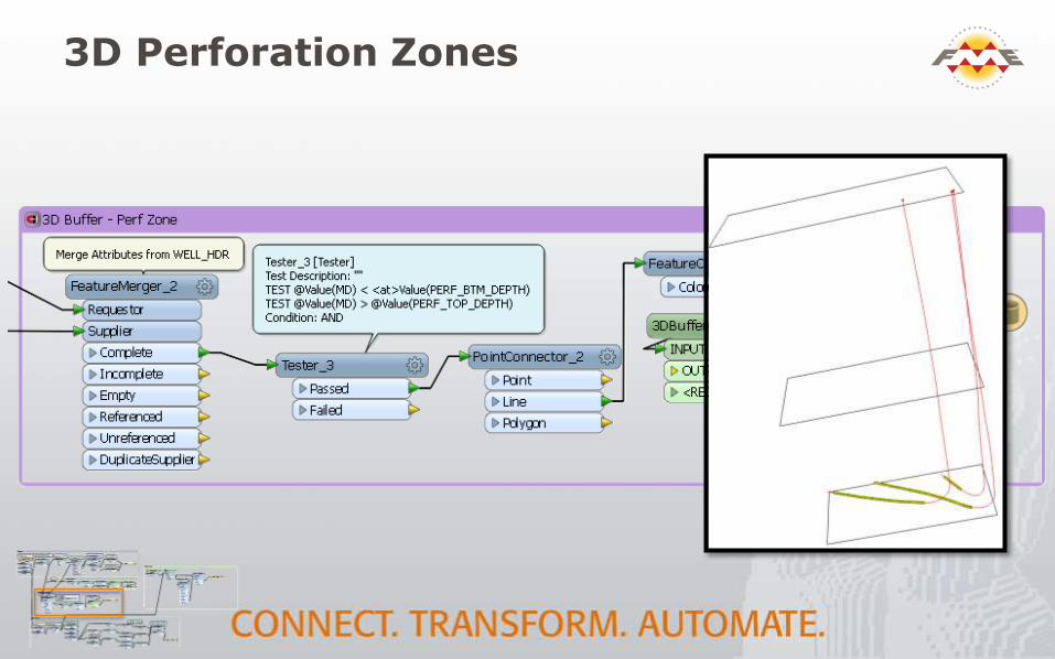
3D Perforation Zones

3D Surface Imagery

Going forward
FeatureReader now has BBOX parameters for WMS! Simplify to one workbench
Allow options for different basemaps (topo, street, etc)
Add surface elevation (DEM)?
Add additional data to PDF like wellbore casings, specific perforation areas, etc.
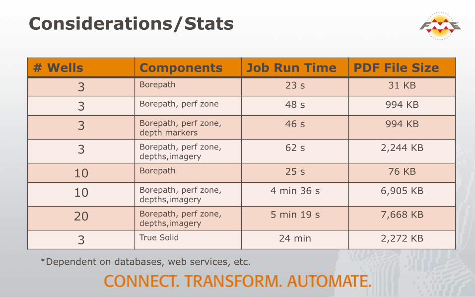
Considerations/Stats
# Wells Components Job Run Time PDF File Size
3 Borepath 23 s 31 KB
3 Borepath, perf zone 48 s 994 KB
3 Borepath, perf zone, depth markers
46 s 994 KB
3 Borepath, perf zone,depths,imagery
62 s 2,244 KB
10 Borepath 25 s 76 KB
10 Borepath, perf zone,depths,imagery
4 min 36 s 6,905 KB
20 Borepath, perf zone,depths,imagery
5 min 19 s 7,668 KB
3 True Solid 24 min 2,272 KB
*Dependent on databases, web services, etc.

FME Enhancements?
Labeling/Text in 3D
More efficient 3D buffering
3D buffering for “True Solid” takes a very long time
3DBufferer (custom transformer) crashes randomly when trying to buffer line features
Feature Reader for WMS with extents
Capability exists in 2015.0 version

Thank You!
Questions?
For more information:
Devon Energy