4. acquiring the data - scenicsolutions.world · mixing geology and geomorphology, laut et al ,...
TRANSCRIPT

Flinders Ranges Landscape Assessment
© Dr Andrew Lothian, Scenic Solutions
33
4. ACQUIRING THE DATA In this chapter the collection of data on which the scenic quality survey was based is described. It covers the classification of the Flinders Ranges landscape and classifies its landscape units. The selection of photographs is described, covering the criteria for their selection, photographing the Flinders Ranges, and the choice of photographs. The design of the Internet survey is described and its implementation on the Internet. Finally the identification and scoring of landscape factors is described. 4.1 CLASSIFICATIONS OF THE
FLINDERS RANGES LANDSCAPE The Flinders Ranges is a region in which the landforms and, to a lesser extent, land cover (vegetation) dominate, and components such as water and land use are of lesser significance. The main determinant of the classification of the Flinders Ranges landscape are the landforms which are analysed by the science of geomorphology describing and explaining the form of the earth’s surface (Twidale, 1969). Geology is the main determinant of the landforms present in an area and can be summarised as follows:
The landscapes of the Flinders Ranges are the result of a geologic history going back to the late Proterozoic, for the patterns of sedimentation and folding that took place between 1000 and 500 million years ago. Similarly very old land surfaces are preserved in this Appalachian type fold belt, with some probably more than 100 million years old and some, admittedly of limited extent, more than 140 million years old… The main outlines of the ridge and valley topography are at least 60 million years old. On the other hand, many landforms, some few of them tectonic, are of recent derivation, and many minor but significant erosional features date from the last 150 – 100 years. (Twidale and Bourne, 1996. In Davies, M., Twidale C.R. and Tyler M.J., Eds.).
Mixing geology and geomorphology, Laut et al, 1977 (p. 101) described the Flinders Ranges thus:
The ranges consist of mainly northerly striking quartzite and sandstone ridges, and intervening lower areas comprising flat to undulating plains or low ridges and hills
on less resistant rocks such as siltstone, shale and calcareous mudstone. In the south intermontane basins with wide, flat, partly alleviated floors are more extensive than in the north where hilly country makes up most of the lowlands. The landforms of the Flinders Ranges are predominantly structural in origin. Differential erosion has occurred, and weathering and denudation have exposed the rock strata or have closely followed the underlying bedrock structure, depending on varying degrees of resistance to these processes. The most impressive landforms are the quartzite hogback ridges which generally form the highest and steepest parts of the ranges. They consist of precipitous rocky escarpments on one side and opposing steep but relatively smooth dipslopes, in close sympathy with the tilted bedding planes, on the other.
Source: Twidale, 1969. Shows the principal sandstone outcrops (dark) which form the main ridges and ranges, major structural trends and main drainage elements. The map extends from south of Hawker, north to the Gammons but omits the Arkaroola area.

Flinders Ranges Landscape Assessment
© Dr Andrew Lothian, Scenic Solutions
34
Figure 4.1 Structural map of the Flinders Ranges
The geomorphologist, Dr Roland Twidale, has mapped the major structural elements and trends in the Ranges (Figure 4.1). This clearly identifies the quartzite hogback ridges throughout the Flinders Ranges and the high granitic ranges of the Gammon Ranges.
In the mid 1970s, the CSIRO (Laut et al, 1977) carried out a major study, The Environments of South Australia, using Landsat imagery to test a methodology for possible national application. The Environments of South Australia produced seven volumes covering each of the major physiographic regions of the State. The study divided the Flinders Ranges into two Environmental Regions: Southern Basins and Ranges Environmental Region (6.1) and Northern Complex Environmental Region (6.2). The former included the area from Hawker north to Blinman and Puttapa on the west and nearly to Mt Chambers on the east. The latter covered the Patawarta Hill – Mt Hack – Gammon Ranges – Freeling Heights area and extended west to Leigh Creek. Figure 4.2 indicates the boundaries of the Environmental Regions and Environmental Associations for the Flinders Ranges. Laut’s report also included comments on the views in each area. Laut et al’s descriptions of the Environmental Regions follow. Southern Basins and Ranges Environmental Region 6.1
(The region) is characterised by series of high quartzite hogback ridges … sand intervening plains and lowlands. Particularly to the south intermontane plains are extensive, commonly with flat alleviated floors. The views consist primarily of foreground to middleground panoramas and perspectives, dominated by abruptly rising ridges, many in the north and west with broken rugged skylines. Watercourses, particularly those which cut through the ridges, provide detailed views, often enclosed by steep rocky walls or dense creek vegetation. The ridges and hills themselves provide panoramic views. A major contributing factor to the visual resources of the region is the strong colouring of the rock outcrops and ephemeral forbs and variable combinations
and contrasts of these occurring in different seasons or at different times of day. 6.1.16 Wilpena Environmental Association included the Elders, Chace & Druids Ranges, Wilpena Pound and Heysen Range. Prominent quartzite hogback ridges with narrow intervening valleys and local basins. There is a mixed cover of tall shrubland, open woodland and low open woodland with an understory of low chenopods and grasses or grasses and ephemeral forbs.
Northern Complex Environmental Region 6.2 Quartzite hogbacks are still present but represent a smaller proportion of the region than do the lower ridges and hills on softer rocks. Intermontane plains and the associated red duplex soils are less prominent than in Region 6.1 The views in the south east and far west of this region are the same as those in region 6.1, i.e. foreground to middleground panoramas and perspectives dominated by abrupt ridges, detailed and enclosed views along watercourses and valleys and panoramas from the ridges, though sparser vegetation here alters the colour and contrast. In the central west, however, between Mt Fitton and Copley … the views open out to middleground and background panoramas, locally dominated by hills or ridges, including ridges of the adjacent associations to the east and south. 6.2.9 The Gammon Environmental Association comprise a steep-sized quart-zite plateau with a well developed erosion surface and dissected margins. The cover is low open woodland and tall shrubland with an understory of grasses and ephemeral forbs some of which is unused, some used for extensive livestock grazing, and some reserved for nature conservation. 6.2.10 The Yudnamunta Environmental Association comprise quartzite strike ridges interspersed with lower ridges on softer rocks. Where this association is not bare, it supports a cover of low open woodland with an understorey of grasses, ephemeral forbs and sparse low shrubs, mostly chenopods, or fringing woodlands.

Flinders Ranges Landscape Assessment
© Dr Andrew Lothian, Scenic Solutions
35
Source: Laut, et al, 1977. Figure 4.2 Flinders Ranges Environmental Regions and Environmental Associations
Flinders Ranges Landscape Assessment
© Dr Andrew Lothian, Scenic Solutions
36
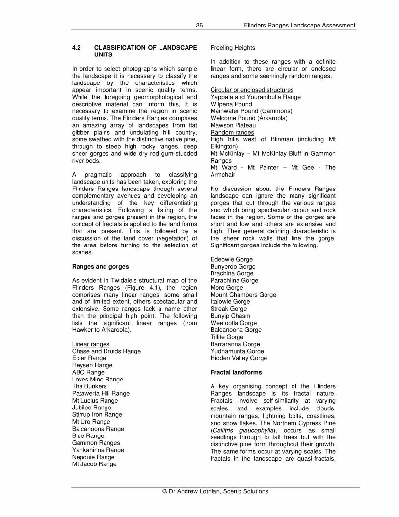
4.2 CLASSIFICATION OF LANDSCAPE UNITS
In order to select photographs which sample the landscape it is necessary to classify the landscape by the characteristics which appear important in scenic quality terms. While the foregoing geomorphological and descriptive material can inform this, it is necessary to examine the region in scenic quality terms. The Flinders Ranges comprises an amazing array of landscapes from flat gibber plains and undulating hill country, some swathed with the distinctive native pine, through to steep high rocky ranges, deep sheer gorges and wide dry red gum-studded river beds. A pragmatic approach to classifying landscape units has been taken, exploring the Flinders Ranges landscape through several complementary avenues and developing an understanding of the key differentiating characteristics. Following a listing of the ranges and gorges present in the region, the concept of fractals is applied to the land forms that are present. This is followed by a discussion of the land cover (vegetation) of the area before turning to the selection of scenes. Ranges and gorges As evident in Twidale’s structural map of the Flinders Ranges (Figure 4.1), the region comprises many linear ranges, some small and of limited extent, others spectacular and extensive. Some ranges lack a name other than the principal high point. The following lists the significant linear ranges (from Hawker to Arkaroola). Linear ranges Chase and Druids Range Elder Range Heysen Range ABC Range Loves Mine Range The Bunkers Patawerta Hill Range Mt Lucius Range Jubilee Range Stirrup Iron Range Mt Uro Range Balcanoona Range Blue Range Gammon Ranges Yankaninna Range Nepouie Range Mt Jacob Range
Freeling Heights In addition to these ranges with a definite linear form, there are circular or enclosed ranges and some seemingly random ranges. Circular or enclosed structures Yappala and Yourambulla Range Wilpena Pound Mainwater Pound (Gammons) Welcome Pound (Arkaroola) Mawson Plateau Random ranges High hills west of Blinman (including Mt Elkington) Mt McKinlay – Mt McKinlay Bluff in Gammon Ranges Mt Ward - Mt Painter – Mt Gee - The Armchair No discussion about the Flinders Ranges landscape can ignore the many significant gorges that cut through the various ranges and which bring spectacular colour and rock faces in the region. Some of the gorges are short and low and others are extensive and high. Their general defining characteristic is the sheer rock walls that line the gorge. Significant gorges include the following. Edeowie Gorge Bunyeroo Gorge Brachina Gorge Parachilna Gorge Moro Gorge Mount Chambers Gorge Italowie Gorge Streak Gorge Bunyip Chasm Weetootla Gorge Balcanoona Gorge Tillite Gorge Barraranna Gorge Yudnamunta Gorge Hidden Valley Gorge Fractal landforms A key organising concept of the Flinders Ranges landscape is its fractal nature. Fractals involve self-similarity at varying
scales, and examples include clouds,
mountain ranges, lightning bolts, coastlines, and snow flakes. The Northern Cypress Pine (Callitris glaucophylla), occurs as small seedlings through to tall trees but with the distinctive pine form throughout their growth. The same forms occur at varying scales. The fractals in the landscape are quasi-fractals,

Flinders Ranges Landscape Assessment
© Dr Andrew Lothian, Scenic Solutions
37
approximating self similarity rather than exact self similarity. In the Flinders Ranges, examples of fractals abound:
• Small scale rock faces adjacent to a creek, through to towering rock faces adjacent to gorges such as Edeowie and Brachina;
• Rock outcrops as part of hillsides through to whole mountains comprising rock outcrops such as St Marys Peak and Pompeys Pillar at Wilpena, Mt McKinlay Bluff and Mt Painter;
• Hogback ridges which occur as relatively small hills such as the Red Range and the Ulowdna Range in Moralana adjacent to the immense Elders Range and the Wilpena ramparts; and the distinctive ABC Range which run parallel to the iconic Heysen Range;
• Small rounded hills through to tall rounded mountains such as Benbonyathe Hill in the Gammons Ranges;
• Small sinuous watercourses flowing off hills through to massive winding creek systems such as Brachina Creek and Arkaroola Creek which cut through ranges and out to the plains
Within large hogback ridges such as the Heysen Ranges are countless small features of rock faces and outcrops, thus the macro form is copied within by smaller similar forms - fractals within fractals.
St Marys Peak/Wilpena Range and the ABC Range – a fractal landscape, hogback ridge forms at medium and large scale The distinguishing characteristic of the Flinders Ranges landscapes is thus the reproduction at varying scales of essentially similar landforms. A classification of the region’s landscapes as high ranges, low ranges, plains, etc would fail to capture this
characteristic. The fractal scale is the key distinguishing feature of the Flinders Ranges, the similarity of forms at varying scales.
Low hogback ridge of the Red Range in front of the Elders Range – a fractal landscape To apply the concept of fractals to the Flinders Ranges it is necessary to identify the physical elements which provide the basis of self similarity across scales. The key elements in the context of the Flinders Ranges are land form and land cover. In several of the following, a feature may occur in several categories, for example the Elders and Heysen Ranges are both hogback ridges and linear ranges, they also contain rock faces and include striated features.
• Rounded bare hills and mountains
• Rounded vegetated hills and mountains
• Round, rocky hills and mountains (igneous intrusions)
• Hogback ridges – ranges
• Linear ranges
• Peaks
• Striated (i.e. furrowed) hills and ranges
• Gorges
• Rock faces
• Plains Non-fractal landforms:
• Streams - watercourses
• Wide valleys
• Undulating The following illustrates fractals in a range of landforms from small to large scale.

Flinders Ranges Landscape Assessment
© Dr Andrew Lothian, Scenic Solutions
38
Small features Intermediate features Large features
Rounded bare hills and mountains
Rounded vegetated hills and mountains
Round, rocky hills and mountains (igneous intrusions)
Hogback ridges – ranges
Peaks

Flinders Ranges Landscape Assessment
© Dr Andrew Lothian, Scenic Solutions
39
Small features Intermediate features Large features
Striated hills and ranges
Gorges
Rock faces
Linear ranges
Nepouie Range
Heysen Range

Flinders Ranges Landscape Assessment
© Dr Andrew Lothian, Scenic Solutions
40
Wilpena Range There are also several landforms which do not display fractals, e.g. plains which have no variation in landforms. Their main difference
lies in their land surface (e.g. sand, rock, soil) and the extent of vegetation.
Plains
Streams - watercourses
Wide valleys
Undulating land
Flinders Ranges Landscape Assessment
© Dr Andrew Lothian, Scenic Solutions
41
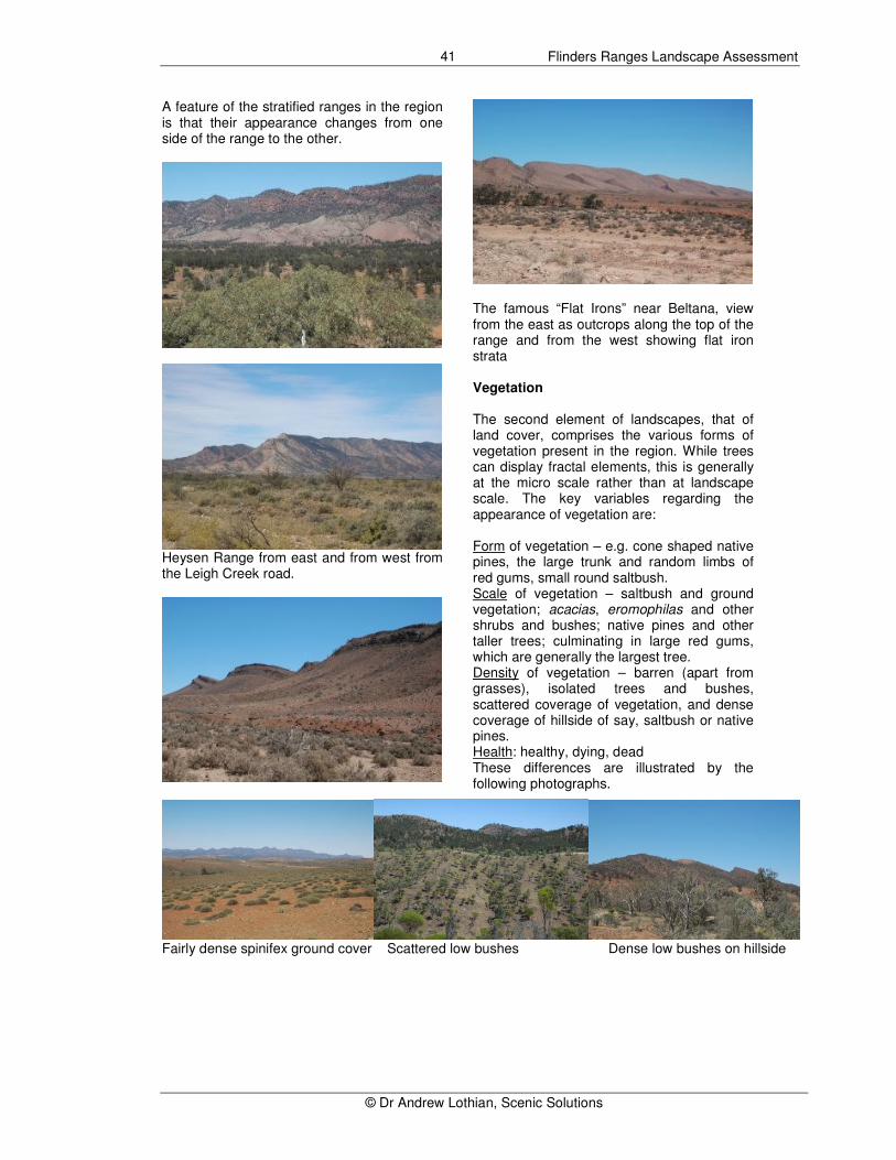
A feature of the stratified ranges in the region is that their appearance changes from one side of the range to the other.
Heysen Range from east and from west from the Leigh Creek road.
The famous “Flat Irons” near Beltana, view from the east as outcrops along the top of the range and from the west showing flat iron strata Vegetation The second element of landscapes, that of land cover, comprises the various forms of vegetation present in the region. While trees can display fractal elements, this is generally at the micro scale rather than at landscape scale. The key variables regarding the appearance of vegetation are: Form of vegetation – e.g. cone shaped native pines, the large trunk and random limbs of red gums, small round saltbush. Scale of vegetation – saltbush and ground vegetation; acacias, eromophilas and other shrubs and bushes; native pines and other taller trees; culminating in large red gums, which are generally the largest tree. Density of vegetation – barren (apart from grasses), isolated trees and bushes, scattered coverage of vegetation, and dense coverage of hillside of say, saltbush or native pines. Health: healthy, dying, dead These differences are illustrated by the following photographs.
Fairly dense spinifex ground cover Scattered low bushes Dense low bushes on hillside

Flinders Ranges Landscape Assessment
© Dr Andrew Lothian, Scenic Solutions
42
Dense medium bushes/low trees Scattered medium eucalypts Dense eucalypt vegetation
Dense eucalypt vegetation Scattered native pines Contrasted with a treeless scene
Dense native pines Dense native pines on flats and River red gums along creek bed
red gums along creek – a typical Flinders scene
0
100
200
300
400
500
600
700
800
900
1000
1940 1950 1960 1970 1980 1990 2000 2010
Annual ra
infa
ll m
m
Source: Bureau of Meteorology data, Station 0179099
Figure 4.3 Annual rainfall at Arkaroola, 1940 - 2008
Dead trees and vegetation are present in some areas of the Flinders Ranges, a result of the ten year drought afflicting particularly the northern Flinders Ranges. Rainfall has been trending down since the early 1990s
(Figure 4.3). The effect of the drought is particularly apparent with dead red gums in creeks in Arkaroola and dead native pines in the Gammons Ranges.

Flinders Ranges Landscape Assessment
© Dr Andrew Lothian, Scenic Solutions
43
Dead and dying red gums, Arkaroola Creek
Dead native pines and other vegetation, Gammons National Park The changing conditions of the Flinders Ranges for vegetation are apparent from old photographs and paintings. The Cazneaux tree outside Wilpena Pound has found new life and the land is in better condition than was apparent in 1937. Similarly, Heysen’s painting of the Three Sisters of the Aroona (1927) which line Aroona Valley (actually comprising part of the ABC Range) showed little vegetation in contrast to their current condition (see Chapter 3). The vegetation of the Flinders Ranges diminishes in size and density the further north one goes. The red gums in creeks are larger in the southern ranges than the north. There are fewer native pines in the north. Considerable regeneration of native vegetation occurred during the heavy rains of the mid 1970s, 1974 in particular when Arkaroola had five times its normal rainfall of 200 mm (Figure 4.3) Operation Bounceback and the rabbit calicivirus have also played significant roles in recent years in reducing grazing pressure by goats and rabbits. However goats in sizeable numbers (40 goats were seen at Yankaninna Station and dozens at Chambers Gorge while taking photographs) which, combined with the ten
year drought in the northern Flinders, are having their toll. Water Water is often a significant attribute of landscapes and in an arid landscape such as the Flinders Ranges, the presence of water is rare and of great importance to supporting life in the region. However its presence is ephemeral and although there are some waterholes which are reasonably permanent, water is not a common landscape element in the Flinders Ranges. The riverbeds are either completely dry or running a banker, but this occurs infrequently and are of limited duration. For this reason water is not considered to be a landscape feature which should be included in the survey. Water may appear, however, in scenes say of gorges. 4.3 SELECTION OF PHOTOGRAPHS Having explored various aspects of the Flinders Ranges landscape, specifically the fractal nature of its landforms and the form of its land cover, photographs need to be selected which reflect the dominant characteristics as well as the variety present in the region. The focus will be on the land-

Flinders Ranges Landscape Assessment
© Dr Andrew Lothian, Scenic Solutions
44
forms present, supplemented by variations in land cover. In addition it is essential that the various highland areas of the Flinders Ranges be represented:
• Elders – Wilpena – Heysen Range
• Patawerta - Mt Hack – Mt Andre - Mt Uro
• Gammons - Arkaroola - Freeling Heights
• Other ranges (see earlier list) Within these areas, scenes should cover the range of landforms and land cover, and reflect the following variations;
• Low elevation, moderate elevation (hills), or high elevation (mountains)
• Close, medium or distant landforms
• With or without trees, shrubs, dead trees, dense or open vegetation, tall or low vegetation
• With land surfaces which may be smooth, stony, rocky or stratified
• With or without distinctive colour (e.g. red)
• With or without water bodies Photographic criteria In selecting photographs for the survey, the aim is to ensure the ratings reflect the quality of the scene, not the quality of the photographs. To help achieve this, photographs should be standardized as far as possible so that the ratings reflect differences in the scenes, not in differences in the photographs. Following are the criteria for photographs which have been established and refined over a series of studies:
• Photographs should be in colour to capture the full characteristics of the landscape.
• Photograph at 50 mm focal length. The focal length of digital cameras is multiplied by 1.5 to equate to convent-ional cameras. (e.g. digital 35 mm = 50 mm conventional camera).
• Photograph in horizontal landscape format, not the vertical portrait format. The photographs should extend where possible to the horizon and avoid close-up confined views.
• Avoid photographic composition of a scene to frame a view or to lead the
viewer into a scene; such composition can enhance its appearance. Aim for good lateral and foreground context to scenes, of a single landscape unit, and of typical representative scenes, not unusual (i.e. rare) scenes. However significant features such as waterfalls, cliffs and water bodies may be included.
• Minimise extraneous features such as people, sheep or cattle, wildlife, fences, electricity poles and wires, and excavations or other eyesores, each of which can influence preferences either positively or negatively. Scenes should not include features of an ephemeral nature as these are not part of the permanent landscape scene.
• Avoid transitory effects of special atmospheric lighting such as sunsets or particularly vivid side lighting. Aim for sunny cloud-free conditions to standardise scenes against a blue sky. Heavy cloud dampens the colour saturation while spectacular cloud formations can enhance the scene.
• Photograph at ground level. It is recognized that this can include scenes from hills and mountain tops of valleys and vistas below and these should include foreground to provide context as otherwise the scene can appear as though it was taken from an aircraft. Photographs would not normally be taken from the air as this is not the usual way the landscape would be viewed.
Overall the ratings should reflect the quality of the scene, not the quality of the photograph, and standardizing photographs as far as possible through the application of these criteria will assist in ensuring this is achieved. It is intended to draw from existing collections of photographs but caution is needed to avoid selecting photographs which are well composed, have appealing lighting or clouds, or have people or other extraneous features. This author has found that about 90% of such collections will be rejected as unsuitable. With Photoshop™ and other similar programs, photographs can be altered, for example to remove extraneous objects. While this can be used to remove people, animals, electricity poles and the like, such manipulation risks the photograph ceasing to accurately represent the landscape and

Flinders Ranges Landscape Assessment
© Dr Andrew Lothian, Scenic Solutions
45
should therefore be used only to edit out unnecessary objects and not to change colours or remove intrinsic features of the landscape. It can be used to substitute a blue sky for clouds or an overcast sky. Indicative allocation of photographs In order to adequately represent the characteristics and variety present in each area of the Flinders Ranges, an indicative allocation of scenes was defined (Table 4.1).
Table 4.1 Indicative allocation of scenes by area
Area Photos
Elders – Wilpena – Heysen Range
40
Patawerta - Mt Hack – Mt Andre - Mt Uro
10
Gammons – Arkaroola – Freeling Heights
50
Other ranges 5 Other areas 15 Total 120
In addition, normally 30 scenes from else-where in South Australia would be added to the survey photographs to benchmark their ratings at a State level. The reason for this is that usually a given region has fairly limited range of landscape quality ratings, for example the survey of the Barossa Valley (Lothian, 2005b) found they ranged only 1.5 ratings (i.e. from 5 to 6.5) on the ten point rating scale. For the entire State ratings ranged from 3 to 8, a range of five units. From the field work and review of the photographs of the Flinders Ranges obtained it is considered likely that the landscape ratings will range over a similar field as the State as a whole. While it is moot whether any scenes will achieve an 8 rating, the inclusion of gibber plains is likely to result in the lowest ratings of 3 or 4. Therefore there did not appear to be the need for as many scenes from elsewhere in South Australia and 20 were therefore selected instead of the normal 30. This enabled some additional scenes from the Flinders Ranges to be included. Photography of the Flinders Ranges Following commencement of the project, arrangements were made to undertake two photographic trips to the Flinders Ranges in October, prior to the summer heat rendering it more problematic. The study methodology
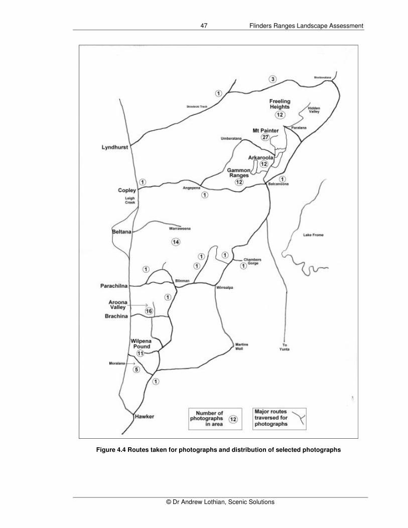
involved photography of the region as the first step. Nine days was spent travelling through the Ranges during which over 1500 photographs were taken (Table 4.2). Figure 4.4 indicates the major routes covered. A Nikon D70 SLR digital camera was used throughout. Its advantage over lesser digital cameras was that the lens could be set at the correct focal length. Digital photographs were recorded at the normal image quality and the medium image size, producing images of 2,240 X 1,488 pixels (3.3 megapixels) which were recorded by 8 – 900 kilobytes. Only a UV filter was used on the camera. Supplementing these photographs were slide and digital photographs from previous visits to the Flinders Ranges and bushwalking in the Ranges, some photographs dating back several decades. Particular emphasis was put on gaining suitable photographs from within the mountainous areas, obtained from bushwalks. Although the majority of these photographs were unsuitable as they did not meet the criteria for photographs – e.g. some included people or were photographed artistically, or were of vertical format or telephoto etc, a relatively small number were selected. Table 4.3 summarises the origin and selection of photographs. The selected slides were scanned digitally using a Plustek™ OpticFilm 7200i scanner at 600 dpi. Care was taken to ensure the colour was as natural as possible. The scans were at 200% to provide sufficient size to reduce the pixilation effect upon enlargement. Jpeg files were derived and used for the survey. Photoshop™ was used to remove images of people and other features in six of the slides. However these had been scanned earlier at only 100% and some pixilation resulted. Selection of photographs The number of potential and selected photographs in each area is summarized by Table 4.4. Overall the survey comprised 147 photographs consisting of 20 South Australia scenes and 127 Flinders Ranges scenes. Considerable effort was given to ensure representation of the highland areas but it was inevitable that some key areas were omitted due to the lack of any photographs to select or from a lack of suitable photographs. Nevertheless it is considered that the coverage of the key highland areas was reasonably adequate.

Flinders Ranges Landscape Assessment
© Dr Andrew Lothian, Scenic Solutions
46
Table 4.2 Photographic trips to Flinders Ranges Date Area Weather Photographs
14 Oct Hawker – Rawnsley – Bunyeroo Valley – Brachina Gorge – Parachilna – Leigh Creek – Arkaroola
Fine, warm, sunny
176
15 Oct Arkaroola: Arkaroola Creek rockhole – Echo Camp – Barrannana Gorge – Paralana Hot Springs – Claude Pass – Arkaroola
Fine, warm, sunny
146
16 Oct Arkaroola ridgetop tour: Coultards lookout – Split Rock – Sillers lookout
Fine, warm, sunny
179
17 Oct Arkaroola – Gammon Ranges loop track (Grindels Hut) – Italowie Gorge – Angepena – Mt Searle – Yankaninna – Umberatana – Arkaroola
Fine, warm, sunny
176
24 Oct Hawker – Moralana track – Rawnsley – Hucks & Stokes lookouts – Aroona Valley – Blinman – Moolooloo loop – side trip to Moolooloo – Angorichina
Fine, hot, sunny 293
25 Oct Angorichina – Blinman – Narrina – Pinda Springs – Chambers Gorge – Balcanoona - Arkaroola
Fine, hot, increasingly overcast
129
26 Oct Arkaroola – Paralana – Hidden Valley – Paralana – Welcome Pound – Mt Jacob track - Arkaroola
Fine, very windy and increasing dust, very hot
178
27 Oct Arkaroola – Balcanoona – Moolawatana – Lyndhurst – Beltana – Warraweena – Beltana – Parachilna
Fine, warm, sunny
243
28 Oct Parachilna - Hawker Fine, warm, sunny
30
Total 1550
Table 4.3 Sources of additional photographs
Name Total Potential Selected
Peter Beer - slides 400 110 12 Arthur Ward - slides 64 3 1 Tony Lothian - slides 500 49 1 Liz - digital 92 13 1 DEH Janice Goodwins – digital 167 6 0 DEH Bob Innes – digital 87 5 0 Andrew Lothian - slides 336 44 8 Andrew Lothian - digital 696 76 11 Total 2342 306 34 Note: These photographs have not been assigned to areas as in the previous Table.
. Table 4.4 Potential and selected photographs by area
Proposed Available Selected %
Elders – Wilpena – Heysen Range 40 1078 35 27.6 Patawerta - Mt Hack – Mt Andre - Mt Uro 10 133 16 12.6 Gammons – Arkaroola – Freeling Heights 50 683 64 50.4 Other areas 20 302 9 7.1 Lighting of mountain 3 2.4 Total 120 2196 127 100.0 South Australia scenes 30 20
Total survey 150 147
Flinders Ranges Landscape Assessment
© Dr Andrew Lothian, Scenic Solutions
47
Figure 4.4 Routes taken for photographs and distribution of selected photographs
Flinders Ranges Landscape Assessment
© Dr Andrew Lothian, Scenic Solutions
48
4.4 DESIGN OF THE INTERNET SURVEY Previous experience had shown the efficiency of using the Internet to conduct surveys. To achieve rapid and cost efficient results the Internet was relied upon exclusively for the surveys. In Australia, household access to the Internet has risen rapidly from 16% in 1998 to 67% in 2007-08, and together with access via workplaces, schools and libraries the overall access was 72% (ABS, 2008). The figure for South Australia was 70%. Over half (52%) the Australian households had access via broadband connections. The figure for South Australia was 42%. Although a minority (mainly the very young and older people) may not have access, these figures suggest that reliance on the Internet should not significantly restrict participation in the survey. A sub-consultant, David Whiterod, prepared the survey instrument using the Internet. Mr Whiterod had undertaken similar work previously for the author (Lothian, 2003; 2004, 2005, 2007). Over these surveys there has been considerable refinement of the survey instrument. Mr. Whiterod has provided the following technical description of the Internet survey.
The use of the Internet to deliver the survey introduced a number of challenges and required certain assumptions to be made about respondents, their web browsers, screen configurations and Internet connection speeds. The survey website was developed to cater for as large an audience as possible (slightly erring on the conservative side when making assumptions about respondents' Internet speed and screen size). The site and survey application was developed using Adobe' Cold Fusion Application Server. The landscape assessment survey was an image-intensive process; the cumulative file sizes of the scene images were quite large. This was not generally a problem for respondents with broadband (or faster) connections. To cater for people with slower Internet connection speeds (such as those with dial-up Internet connections), two sets of scene images were created. Both sets of images were identical in all respects except the level of JPEG compression
used. A set (with a compression level of 80) was developed for use by broadband users while another set (compression level 60) was developed for dial-up users. The total file size of the dial-up images was around 60% of that of the broadband images. The image compression settings were a trade-off between compression and image detail. As the level of JPEG compression increased the general quality of an image decreased. If images were compressed too much this would affect the ability for respondents to see fine details in an image and would result in "blockier" images. The trade-off was that high quality scenes were slower to download. Each image set was resized to (approx) 585 by 400 pixels. This size fitted well into a screen size near 800 by 600 pixels. The page layout also performed well at larger screen resolutions. A MySQL Database Server was used to record both the demographic details as well as the ratings of each scene. The survey website was designed to be as self-contained as possible. The front page included details of the survey process, background and contact information. If the respondent chose to proceed to the survey they were prompted to enter some general demographic information. This information was recorded in the database and a unique survey identifier generated for each respondent. This initiated the survey session. The respondent's session identifier was used to record scene ratings with the correct demographic details. As the participant rated each scene, their rating was automatically recorded in the database. The respondent characteristics used were the categories of the Australian Bureau of Statistics and were included to compare the respondents with the community. As part of the demographic collection stage, respondents were asked to indicate their Internet connection speed: either dial-up or broadband. This information was used to reduce the download requirements for dial-up users as they were shown a more compressed set of scene images.
Flinders Ranges Landscape Assessment
© Dr Andrew Lothian, Scenic Solutions
49
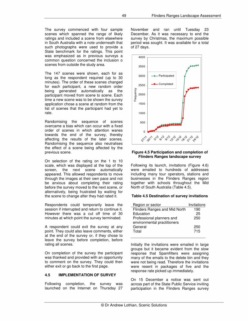
The survey commenced with four sample scenes which spanned the range of likely ratings and included a scene from elsewhere in South Australia with a note underneath that such photographs were used to provide a State benchmark for the ratings. This point was emphasized as in previous surveys a common question concerned the inclusion o scenes from outside the study area. The 147 scenes were shown, each for as long as the respondent required (up to 30 minutes). The order of these scenes changed for each participant, a new random order being generated automatically as the participant moved from scene to scene. Each time a new scene was to be shown the survey application chose a scene at random from the list of scenes that the participant had yet to rate. Randomising the sequence of scenes overcame a bias which can occur with a fixed order of scenes in which attention wanes towards the end of the survey, thereby affecting the results of the later scenes. Randomising the sequence also neutralises the effect of a scene being affected by the previous scene. On selection of the rating on the 1 to 10 scale, which was displayed at the top of the screen, the next scene automatically appeared. This allowed respondents to move through the images at their own pace and not be anxious about completing their rating before the survey moved to the next scene, or alternatively, being frustrated by waiting for the scene to change after they had rated it. Respondents could temporarily leave the session if interrupted and return to continue it. However there was a cut off time of 30 minutes at which point the survey terminated. A respondent could exit the survey at any point. They could also leave comments, either at the end of the survey or, if they chose to leave the survey before completion, before rating all scenes. On completion of the survey the participant was thanked and provided with an opportunity to comment on the survey. They could then either exit or go back to the first page. 4.5 IMPLEMENTATION OF SURVEY Following completion, the survey was launched on the Internet on Thursday 27
November and ran until Tuesday 23 December. As it was necessary to end the survey by Christmas, the maximum possible period was sought. It was available for a total of 27 days.
0
500
1000
1500
2000
2500
3000
3500
4000
27/1
1
30/1
13/
126/
129/1
2
12/1
2
15/1
2
18/1
2
21/1
2
24/1
2F
req
ue
ncy
Participated
Completed
Figure 4.5 Participation and completion of
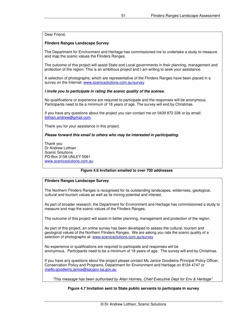
Flinders Ranges landscape survey Following its launch, invitations (Figure 4.6) were emailed to hundreds of addresses including many tour operators, stations and businesses in the Flinders Ranges region together with schools throughout the Mid North of South Australia (Table 4.5). Table 4.5 Destination of survey invitations Region or sector Invitations
Flinders Ranges and Mid North 190 Education 25 Professional planners and environmental practitioners
250
General 250 Total 715
Initially the invitations were emailed in large groups but it became evident from the slow response that Spamfilters were assigning many of the emails to the delete bin and they were not being read. Therefore the invitations were resent in packages of five and the response rate picked up immediately. On 15 December a notice was sent out across part of the State Public Service inviting participation in the Flinders Ranges survey

Flinders Ranges Landscape Assessment
© Dr Andrew Lothian, Scenic Solutions
50
(Figure 4.7). Unfortunately because of delays, it was left to the final week of the survey. Prior to it commencing, approximately 380 had completed the survey with an average completion rate of 84%. Due to heavy traffic on the site this fell initially to 47.5% but quickly recovered to around 66.5% over the following week (Figure 4.5). The Internet survey is shown in pages 51 - 58.
Flinders Ranges Landscape Assessment
© Dr Andrew Lothian, Scenic Solutions
51
Dear Friend, Flinders Ranges Landscape Survey The Department for Environment and Heritage has commissioned me to undertake a study to measure and map the scenic values the Flinders Ranges. The outcome of this project will assist State and Local governments in their planning, management and protection of the region. This is an ambitious project and I am writing to seek your assistance. A selection of photographs, which are representative of the Flinders Ranges have been placed in a survey on the Internet: www.scenicsolutions.com.au/survey I invite you to participate in rating the scenic quality of the scenes. No qualifications or experience are required to participate and the responses will be anonymous. Participants need to be a minimum of 18 years of age. The survey will end by Christmas. If you have any questions about the project you can contact me on 0439 872 226 or by email: [email protected]. Thank you for your assistance in this project. Please forward this email to others who may be interested in participating. Thank you Dr Andrew Lothian Scenic Solutions PO Box 3158 UNLEY 5061 www.scenicsolutions.com.au
Figure 4.6 Invitation emailed to over 700 addresses
Flinders Ranges Landscape Survey
The Northern Flinders Ranges is recognised for its outstanding landscapes, wilderness, geological, cultural and tourism values as well as its mining potential and interest.
As part of broader research, the Department for Environment and Heritage has commissioned a study to measure and map the scenic values of the Flinders Ranges.
The outcome of this project will assist in better planning, management and protection of the region.
As part of this project, an online survey has been developed to assess the cultural, tourism and geological values of the Northern Flinders Ranges. We are asking you rate the scenic quality of a selection of photographs at: www.scenicsolutions.com.au/survey
No experience or qualifications are required to participate and responses will be anonymous. Participants need to be a minimum of 18 years of age. The survey will end by Christmas.
If you have any questions about the project please contact Ms Janice Goodwins Principal Policy Officer, Conservation Policy and Programs, Department for Environment and Heritage on 8124 4747 or mailto:[email protected]
“This message has been authorised by Allan Holmes, Chief Executive Dept for Env & Heritage”
Figure 4.7 Invitation sent to State public servants to participate in survey
Flinders Ranges Landscape Assessment
© Dr Andrew Lothian, Scenic Solutions
52
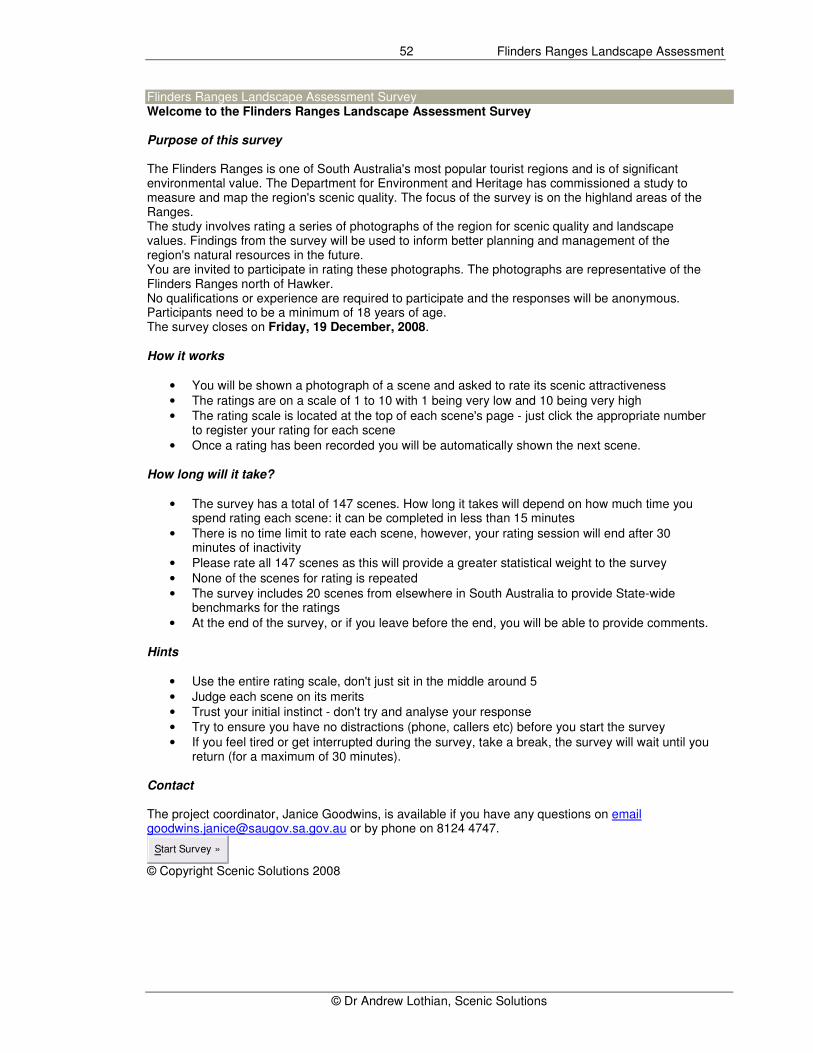
Flinders Ranges Landscape Assessment Survey Welcome to the Flinders Ranges Landscape Assessment Survey Purpose of this survey The Flinders Ranges is one of South Australia's most popular tourist regions and is of significant environmental value. The Department for Environment and Heritage has commissioned a study to measure and map the region's scenic quality. The focus of the survey is on the highland areas of the Ranges. The study involves rating a series of photographs of the region for scenic quality and landscape values. Findings from the survey will be used to inform better planning and management of the region's natural resources in the future. You are invited to participate in rating these photographs. The photographs are representative of the Flinders Ranges north of Hawker. No qualifications or experience are required to participate and the responses will be anonymous. Participants need to be a minimum of 18 years of age. The survey closes on Friday, 19 December, 2008. How it works
• You will be shown a photograph of a scene and asked to rate its scenic attractiveness
• The ratings are on a scale of 1 to 10 with 1 being very low and 10 being very high
• The rating scale is located at the top of each scene's page - just click the appropriate number to register your rating for each scene
• Once a rating has been recorded you will be automatically shown the next scene. How long will it take?
• The survey has a total of 147 scenes. How long it takes will depend on how much time you spend rating each scene: it can be completed in less than 15 minutes
• There is no time limit to rate each scene, however, your rating session will end after 30 minutes of inactivity
• Please rate all 147 scenes as this will provide a greater statistical weight to the survey
• None of the scenes for rating is repeated
• The survey includes 20 scenes from elsewhere in South Australia to provide State-wide benchmarks for the ratings
• At the end of the survey, or if you leave before the end, you will be able to provide comments. Hints
• Use the entire rating scale, don't just sit in the middle around 5
• Judge each scene on its merits
• Trust your initial instinct - don't try and analyse your response
• Try to ensure you have no distractions (phone, callers etc) before you start the survey
• If you feel tired or get interrupted during the survey, take a break, the survey will wait until you return (for a maximum of 30 minutes).
Contact The project coordinator, Janice Goodwins, is available if you have any questions on email [email protected] or by phone on 8124 4747.
Start Survey »
© Copyright Scenic Solutions 2008
Flinders Ranges Landscape Assessment
© Dr Andrew Lothian, Scenic Solutions
53
Flinders Ranges Landscape Assessment Survey
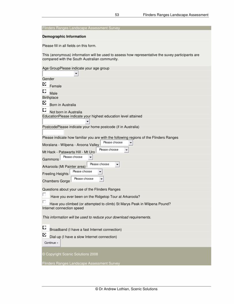
Demographic Information
Please fill in all fields on this form.
This (anonymous) information will be used to assess how representative the suvey participants are compared with the South Australian community.
Age GroupPlease indicate your age group
Gender
Female
Male Birthplace
Born in Australia
Not born in Australia EducationPlease indicate your highest education level attained
PostcodePlease indicate your home postcode (if in Australia)
Please indicate how familiar you are with the following regions of the Flinders Ranges
Moralana - Wilpena - Aroona Valley Please choose
Mt Hack - Patawarta Hill - Mt Uro Please choose
Gammons Please choose
Arkaroola (Mt Painter area) Please choose
Freeling Heights Please choose
Chambers Gorge Please choose
Questions about your use of the Flinders Ranges
Have you ever been on the Ridgetop Tour at Arkaroola?
Have you climbed (or attempted to climb) St Marys Peak in Wilpena Pound? Internet connection speed
This information will be used to reduce your download requirements.
Broadband (I have a fast Internet connection)
Dial-up (I have a slow Internet connection)
Continue »
© Copyright Scenic Solutions 2008
Flinders Ranges Landscape Assessment Survey
Flinders Ranges Landscape Assessment
© Dr Andrew Lothian, Scenic Solutions
54
You are about to start the survey
Example Landscapes
• The survey will start with a series of 4 example landscapes. This will give you an example of the types of landscapes you will be asked to rate during the survey.
• During the example landscapes phase you can continue to the next landscape by either clicking the photograph or the rating buttons at the top of the page (these ratings are not recorded), otherwise the page will automatically progress to the next example landscape after a few seconds.
Start Survey »
Example Landscapes
Exit Survey
Dislike very much 1
2
3
4
5
6
7
8
9
10
Like very much
Continue to the next example landscape by clicking the photograph or the rating buttons (above) otherwise this page will automatically progress to the next example landscape.
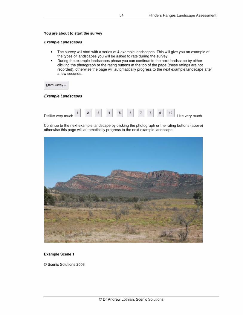
Example Scene 1
© Scenic Solutions 2008
Flinders Ranges Landscape Assessment
© Dr Andrew Lothian, Scenic Solutions
55
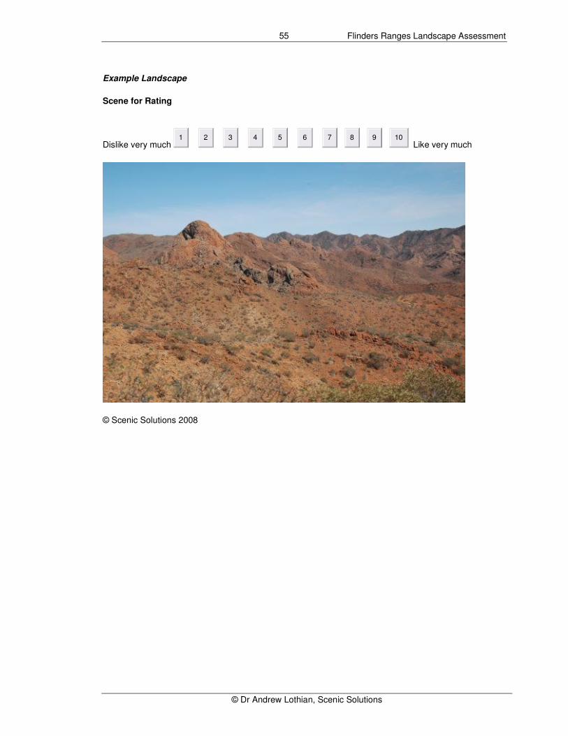
Example Landscape
Scene for Rating Exit Survey
Dislike very much 1
2
3
4
5
6
7
8
9
10
Like very much
© Scenic Solutions 2008
Flinders Ranges Landscape Assessment
© Dr Andrew Lothian, Scenic Solutions
56
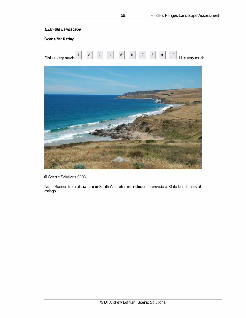
Example Landscape
Scene for Rating Exit Survey
Dislike very much 1
2
3
4
5
6
7
8
9
10
Like very much
© Scenic Solutions 2008
Note: Scenes from elsewhere in South Australia are included to provide a State benchmark of ratings.
Flinders Ranges Landscape Assessment
© Dr Andrew Lothian, Scenic Solutions
57
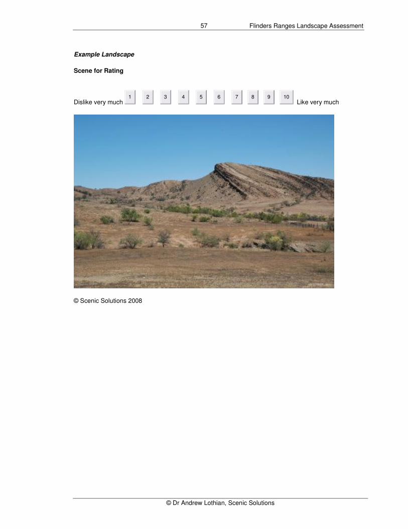
Example Landscape
Scene for Rating Exit Survey
Dislike very much 1
2
3
4
5
6
7
8
9
10
Like very much
© Scenic Solutions 2008

Flinders Ranges Landscape Assessment
© Dr Andrew Lothian, Scenic Solutions
58
(Example of scene for rating)
Dislike very much 1
2
3
4
5
6
7
8
9
10
Like very much
Scene 24 of 147 Exit Survey
© Copyright Scenic Solutions 2008

Flinders Ranges Landscape Assessment
© Dr Andrew Lothian, Scenic Solutions
59
Flinders Ranges Landscape Assessment Survey
Thank you for completing the survey
Please feel free to submit any comments you may have about the survey or about the Flinders Ranges.
Please note:
• The survey did not contain any repeated scenes
• Scenes from outside the Flinders Ranges were included to provide a State-wide benchmark for the ratings
• Because some of the scenes were scanned from slides, their quality was somewhat inferior for which we apologise.
Your comments
Submit
No Comments
If you would like to find out more about these surveys of landscape quality, click here.
Otherwise you have completed the survey and may close your web browser window now.
© Copyright Scenic Solutions 2008

Flinders Ranges Landscape Assessment
© Dr Andrew Lothian, Scenic Solutions
60
4.6 IDENTIFICATION AND SCORING OF LANDSCAPE FACTORS
Nature and use of landscape factors The scenic quality of scenes derives from their content and the particular features they contained that trigger responses in participants. The presence of water for example almost invariably enhances scenic quality as also does the naturalness of the scene, the presence of trees, and high, steep landforms such as cliffs. Such features are termed landscape factors. The identification of landscape factors allows the analysis of the ratings to proceed beyond the mere description of the ratings to understand why scenes gain the ratings they do. In enables the relationships between the ratings and the landscape factors to be quantified. Multiple regression analysis allowed these landscape factors (which are the independent variables) to be compared with the ratings (the dependent variable) and to both identify and quantify which landscape factors contributed to the ratings and their relative importance. Depending on the selection of landscape factors, the models which are derived can explain a large proportion (say 75%) of the variance of the data. In an earlier study of the amenity value of trees (Lothian, 2004) it was found that the spacing and number of trees, their health and their height were the most important factors. In the survey of coastal scenic quality (Lothian, 2005a), the sense of tranquility or awe, the quality of the beach, the degree of naturalness, the height of landforms and the diversity in the scene were all found to be important contributors. In the Barossa survey, naturalness, presence of trees and the terrain were the main positive factors. The study found that scenic quality decreased with the presence of vines but increased with the presence of trees, due to the lack of trees amidst vineyards (Lothian, 2005b). The survey of the River Murray found, that as would be expected, water to have a significant influence along with trees, cliffs, naturalness and diversity (Lothian, 2007). Scoring the landscape factors thus provides insights into what affects scenic quality both positively and negatively.
The landscape factors were scored on a 1 (low) to 5 (high) scale to differentiate the scores from the 1 – 10 scale landscape quality ratings. Selection of landscape factors The Flinders Ranges includes spectacular mountain scenery with high cliffs, prominent vegetation including red gums (Eucalyptus camaldulensis) and native pines (Callitris spp), and a distinctive quality is the red – orange colour present in the rocks. Although important in landscapes when it is present, water was absent in virtually all of the survey scenes. Based on experience from earlier surveys and through examining the scenes used in this survey, eight landscape factors were identified as likely to contribute to the scenic quality of the Flinders Ranges. Terrain – how important or significant are the landforms in the scene Dull – Awe inspiring (impressive, spectacular) These two separate factors sought to establish, firstly the overall level of significance that landforms play in the landscape and, secondly, the degree to which this related to their impressive, spectacular and awe-inspiring qualities. It was expected that landforms played a key role in the landscape of the Flinders Ranges. Vegetation – how important or significant is the vegetation in the scene The presence of vegetation usually enhances scenic quality but the form of the vegetation is important; trees contribute positively but low ground vegetation or shrub layers are of lesser importance. Naturalness – how natural it appears In most of the studies to date, naturalness has been found to play a significant role in determining scenic quality. The quality measured is the perceived naturalness (as it appears), not necessarily its ecological naturalness. Much of the Australian landscape has been affected by human influence such as grazing and native vegetation clearance. In many areas, housing and other developments, roads, powerlines and other infrastructure, farm structures and fences have been constructed. Their presence and that of stock, vines, pines and

Flinders Ranges Landscape Assessment
© Dr Andrew Lothian, Scenic Solutions
61
other artificial features all detract from the appearance of naturalness. Diversity – the busyness of the scene Diversity measures the “busyness” of the scene; the variety of land forms, land uses, land cover (vegetation), water, colour and other features that were present in the scene. Together with naturalness, diversity has a strong positive influence on scenic quality. Both are derived qualities from the totality of the scene, they are not objectively present in the manner that vegetation and landforms are. Colour - how important or significant is the colour in the scene It is difficult to assess the landscape of the Flinders Ranges without considering the significant role that colour plays. The southern Flinders, between Crystal Brook and Mt Arden are characterised by their greenness with generally abundant vegetation cover. Further north the vegetation becomes more scattered and the colour of the underlying rock comes through. This is typically red and orange, hues which are more striking in morning or evening light, much beloved by photographers such as Stavros Pippos and Pete Dobré. Aridity – lushness – how lush or arid is the scene The aridity of the landscape is a characteristic of the Flinders Ranges and this may affect preferences, it generally being found that people prefer lush landscapes. The prevailing theories of landscape aesthetics are based on an evolutionary perspective, that the landscape is survival enhancing. The question therefore is, how can this follow in an arid region such as the Flinders Ranges? The survey provides an opportunity to explore the underlying human preferences regarding landscapes. Rockfaces – Steepness and extent Following the finding in the earlier survey (Lothian, 2000) of the positive influence that the steepness and extent of rockfaces in the Flinders Ranges and other areas had on ratings, these were assessed in this survey. The factor was added after the others had been scored and a further scoring session was held.

Flinders Ranges Landscape Assessment
© Dr Andrew Lothian, Scenic Solutions
62