4 developing arcgis server...
TRANSCRIPT

DevelopingArcGIS Server
applications
Programming ArcGIS Server applications is about programming with ArcObjects
that are running remotely on a server. Developers can become effective ArcGIS
Server application developers if they understand the ArcObjects programming
model and some key rules for programming with the server.
This chapter contains important information including rules and best practices for
developing ArcGIS Server applications. If you are building Web applications and
Web services with .NET or Java, this chapter is a must read and complements
later chapters that focus on .NET and Java development.
This chapter covers topics such as:
• the ArcGIS Server API • working with ArcObjects in the server • working with
server contexts • stateful versus stateless use of the ArcGIS Server • application
performance and scalability
4
Chapter4.pmd 02/16/2005, 10:15 AM71
72 • ArcGIS Server Administrator and Developer Guide
Programming ArcGIS Server applications is all about programming ArcObjects.The key to programming ArcGIS Server applications is that these applicationswork with ArcObjects that actually run remotely on container machines managedby your GIS server.
An application developer who can use ArcObjects to build an application thatruns on the desktop can also build ArcGIS Server applications by learning somerules and programming patterns for working with remote ArcObjects. ArcGISServer is a platform for building Web applications and Web services. While theArcObjects programming model for ArcGIS Server will be familiar to ArcObjectsdevelopers, developing Web applications does require knowledge of Internetprogramming using frameworks such as ASP.NET and J2EE.
This chapter will focus on the ArcObjects programming rules and patterns toprogram ArcGIS Server applications. The information in this chapter is comple-mentary to information about using ArcGIS Server that is more specific to devel-oping Web applications using the .NET and Java ADFs in Chapter 5, ‘DevelopingWeb applications with .NET’, and Chapter 6, ‘Developing Web applications withJava’, respectively.
It is recommended that developers first become familiar with the ArcObjectsprogramming model, which is discussed in great detail in the ArcGIS DeveloperHelp system and in the appendixes of this book. This chapter assumes knowledgeof ArcObjects, except where the programming APIs and patterns are specific toArcGIS Server development.
ARCGIS SERVER DEFINITIONS AND CONCEPTS
Before diving into the details, it’s important to review some key terms and con-cepts from Chapter 1, ‘Introducing ArcGIS Server’, and Chapter 2, ‘The ArcGISServer architecture’, that will be used throughout this chapter:
GIS server: The GIS server is responsible for hosting and managing server objects.The GIS server is the set of objects, applications, and services that make it pos-sible to run ArcObjects components on a server. The GIS server consists of aserver object manager and one or more server object containers.
Server object manager: The SOM is a Windows service or a UNIX daemon thatmanages the set of server objects that are distributed across one or more con-tainer machines. When an application makes a connection to an ArcGIS Serverover a LAN, it is making a connection to the SOM.
Server object container: A SOC is a process in which one or more server objects isrunning. SOC processes are started and shut down by the SOM. The SOC pro-cesses run on the GIS server’s container machines. Each container machine iscapable of hosting multiple SOC processes.
Server object: A server object is a coarse-grained ArcObjects component, that is, ahigh-level object that simplifies the programming model for doing certain opera-tions and hides the fine-grained ArcObjects that do the work. Server objectssupport coarse-grained interfaces that have methods that do large units of work,such as “draw a map” or “geocode a set of addresses”. Server objects also haveSOAP interfaces, which make it possible to expose server objects as Web servicesthat can be consumed by clients across the Internet.
PROGRAMMING ARCGIS SERVER APPLICATIONS
Chapter4.pmd 02/16/2005, 10:15 AM72

Chapter 4 • Developing ArcGIS Server applications • 73
PROGRAMMING ARCGIS SERVER APPLICATIONS
Web server: The Web server hosts Web applications and Web services written usingthe ArcGIS Server API. These Web applications use the ArcGIS Server API toconnect to a SOM to make use of server objects and to create ArcObjects for usein their applications.
Pooled server object: ArcGIS Server allows you to pool instances of server objectssuch that they can be shared between multiple application sessions at the per-request level. This allows you to support more users with fewer resources. Pooledserver objects should be used by applications that make stateless use of the GISserver.
Non-pooled server object: Non-pooled server objects are created for exclusive use byan application session and destroyed when returned by the application to theserver. The creation of the object includes creating the object and loading up anyinitialization data, for example, the map document associated with a map serverobject. Users of a server application that makes use of a non-pooled serverobject require an instance of that object dedicated to their session. Non-pooledserver objects are for applications that make stateful use of the GIS server.The ArcGIS Server is a distributed system that
consists of a server object manager, servercontainers, and clients to the server, such asdesktop applications and Web applications.
`
`
`
ArcGISDesktopServers
ArcGISEngine
Applications
WebBrowsers
ArcGISDesktopServers
WebServer
Internet
Java or .NET WebApplicationDevelopers
ArcGIS ServerAdministrator(ArcCatalog) GIS Server
Server ObjectManager
Server Object Containers
File-based dataArcSDE
LAN
Chapter4.pmd 02/16/2005, 10:15 AM73

74 • ArcGIS Server Administrator and Developer Guide
Application developer framework: A collection of Web controls, convenience classesand data objects, and application templates that make it easy to build and deploy.NET or Java Web applications that use ArcObjects running within the GISserver. The ADF includes a software developer kit with Web controls, Webapplication templates, developer help, and code samples. It also includes a Webapplication runtime that allows you to deploy applications without having toinstall ArcObjects on your Web server.
PROGRAMMING ARCGIS SERVER APPLICATIONS
Chapter4.pmd 02/16/2005, 10:15 AM74

Chapter 4 • Developing ArcGIS Server applications • 75
The ArcGIS Server has three application programming interfaces:
• The Server API
• The .NET Web Controls
• The Java Web Controls
This chapter focuses on the server API, and Chapters 5 and 6 focus on the .NETWeb controls and Java Web controls, respectively. It’s important to understandthe relationship between the Web control APIs, server API, and server program-ming model if you want to build applications that go beyond simple map viewingand query.
The server API is a collection of object libraries that contains the ArcObjectsnecessary to write an application that connects to the GIS server and makes useof server objects. These object libraries are available to any developer who in-stalls the ArcGIS Desktop, ArcGIS Engine, or ArcGIS Server products. TheArcGIS Server product also includes a set of Web controls and Web applicationtemplates as part of the ADF. Programming with the ADF and the Web controlsis the subject of Chapter 5, ‘Developing Web applications with .NET’, andChapter 6, ‘Developing Web applications with Java’.
It is possible to write a number of different types of applications using ArcGISServer. The developer who works with the ADF can build server applications,
ARCGIS SERVER APIS
Developers can build different types of ArcGISServer applications. These include multiuser
server applications, such as Web applications andWeb services written using the ADF. ArcGIS
Server also supports single-user desktop applica-tions using the ADF, ArcGIS Engine, or ArcGIS
Desktop products.
`
`
ArcObjectsArcObjectsArcObjects
ArcObjectsProxies
ArcObjectsProxies
ArcObjectsProxies
ArcObjects
ArcObjectsProxies
ArcObjects
`
` `
GIS Server
Desktop applications(single user)
.NET/Java ADF
ArcGIS Engine
ArcGIS Desktop
Server applications(Multi-user)
.NET/Java ADF
Server ObjectManager
Server Object Containers
Chapter4.pmd 02/16/2005, 10:15 AM75

76 • ArcGIS Server Administrator and Developer Guide
such as Web applications, Web services, and enterprise applications—for example,EJBs. Developers can also build desktop applications using .NET or Java. Theseapplications are deployed using the ADF runtime.
ArcGIS Engine developers can build desktop applications that make use ofArcObjects running in the GIS server. ArcGIS Desktop developers can extendthe ArcGIS Desktop applications to include functionality that makes use of theGIS server. In both of these cases, the deployment of the application itselfrequires an ArcGIS Engine runtime deployment license or an ArcGIS Desktoplicense.
In the case of ArcGIS Desktop and ArcGIS Engine, developers who write desk-top applications that use the server will have ArcObjects installed on the machineon which the application is both developed and deployed on. When using theseproducts to write applications that use ArcGIS Server, you must follow the sameprogramming guidelines as a developer using the ADF to build a server applica-tion, such as a Web application that is deployed within a Web server. The onlydifference is that in the case of the desktop application, each instance of yourapplication is bound to a single user session (though there might be multipleinstances of your application running at any time), while Web applications orWeb services are multiuser/multisession applications.
The .NET ADF runtime and Java ADF runtime installation of ArcGIS Server donot include ArcObjects components, but they do include .NET assemblies andobject libraries (OLBs) (in the case of the .NET runtime), and JAR files (in thecase of the Java runtime) that provide proxies for working with ArcObjectsrunning within the server (in addition to Web control APIs). Applications thatare built and deployed using one of the ArcGIS Server runtime installs mustfollow the coding guidelines of the server, or they won’t work. Those aspects ofthe coding guidelines will become more apparent later in this chapter.
THE SERVER API
Programming with the server API is all about remotely programming ArcObjects.Programming ArcObjects remotely is the same as programming ArcObjects foruse in desktop applications, but there are some additional details and program-ming guidelines you need to follow. You need to understand:
• How to connect to the server.
• How to get objects that are running within the server.
• How to create new objects within the server.
• The best ways (dos and don’ts) for working with remote ArcObjects.
The rest of programming the server is just programming ArcObjects. Each aspectof programming the server listed above will be described in more detail in thefollowing sections.
ArcGIS Server developers have access to a set of visual Web controls that permitthe use of many properties, events, and methods. The server has no ArcGISDesktop applications, such as ArcMap, or any user interface components exceptfor the Web controls. Although a simple application can be built with just theWeb controls, practical applications of the server require knowledge of the
A proxy object is a local representation of aremote object. The proxy object controls accessto the remote object by forcing all interaction
with the remote object to be via the proxyobject. The supported interfaces and methods ona proxy object are the same as those supported
by the remote object. You can make method callson, and get and set properties of, a proxy objectas if you were working directly with the remote
object.
ARCGIS SERVER APIS
Chapter4.pmd 02/16/2005, 10:15 AM76
Chapter 4 • Developing ArcGIS Server applications • 77
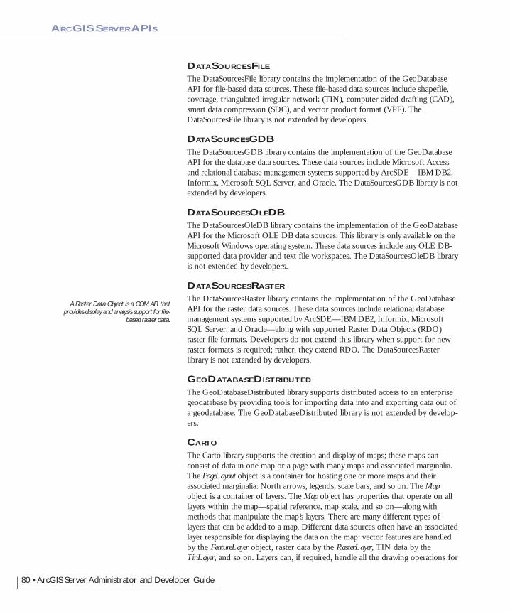
object libraries that compose the ArcGIS Server. The libraries contained withinthe ArcGIS Server are summarized below. The diagrams that accompany thissection indicate the library architecture of the ArcGIS Server. Understanding thelibrary structure, their dependencies, and basic functionality will help you as adeveloper navigate through the components of ArcGIS Server. The libraries arediscussed in dependency order. The diagrams show this with a number in theupper right corner of the library block.
Object libraries are logical collections of the programmable ArcObjects compo-nents, ranging from fine-grained objects (for example, individual geometry ob-jects) to coarse-grained objects, which aggregate logical collections of functional-ity (for example, an ArcMap object to work with map documents). Programmersuse a number of standards-based APIs (COM, .NET, Java, and C++). These samelibraries are used to program the ArcGIS Desktop and the ArcGIS Engine.
SYSTEM
The System library is the lowest level library in the ArcGIS architecture. Thelibrary contains components that expose services used by the other librariescomposing ArcGIS. There are a number of interfaces defined within System thatcan be implemented by the developer. The developer does not extend this librarybut can extend the ArcGIS system by implementing interfaces contained withinthis library.
SYSTEMUIThe SystemUI library contains the interface definitions for user interface compo-nents that can be extended within the ArcGIS system. These include theICommand, ITool, and IToolControl interfaces. The objects contained within thislibrary are utility objects available to the developer to simplify some user interfacedevelopments. The developer does not extend this library but can extend theArcGIS system by implementing interfaces contained within this library.
GEOMETRY
The Geometry library handles the geometry, or shape, of features stored in fea-ture classes or other graphical elements. The fundamental geometry objects thatmost users will interact with are Point, MultiPoint, Polyline, and Polygon. Besidesthose top-level entities are geometries that serve as building blocks for polylinesand polygons. Those are the primitives that compose the geometries. They areSegments, Paths, and Rings. Polylines and polygons are composed of a sequence ofconnected segments that form a path. A segment consists of two distinguishedpoints, the start and the end point, and an element type that defines the curvefrom start to end. The types of segments are CircularArc, Line, EllipticArc, andBezierCurve. All geometry objects can have Z, M, and IDs associated with theirvertices. The fundamental geometry objects all support geometric operations suchas Buffer and Clip. The geometry primitives are not meant to be extended bydevelopers.
Entities within a GIS refer to real-world features; the location of these real-worldfeatures is defined by a geometry along with a spatial reference. Spatial referenceobjects, for both projected and geographic coordinate systems, are included in theGeometry library. Developers can extend the spatial reference system by addingnew spatial references and projections between spatial references.
CONNECTING TO THE GIS SERVERARCGIS SERVER APIS
For a comprehensive discussion on each library,refer to the library overview topics, a part of thelibrary reference section of the ArcGIS Developer
Help system.
Knowing the library dependency order isimportant since it affects the way in which
developers interact with the libraries as theydevelop software. As an example, C++ develop-
ers must include the type libraries in the librarydependency order to ensure correct compilation.
Understanding the dependencies also helps whendeploying your developments.
Chapter4.pmd 02/16/2005, 10:15 AM77

78 • ArcGIS Server Administrator and Developer Guide
Contains components that exposeservices used by the other librariescomposing ArcGIS.
Defined types used by userinterface components in theArcGIS system such asICommand and ITool.
Contains the core geometryobjects and defines andimplements the spatial referenceobjects for coordinate systems.
Contains types for all the definitions relatingto data access. Features, tables, networks,and TINs are all defined in this library.
Contains components that supportdrawing symbology to an outputdevice.
Contains the workspace factories andworkspaces for vector and raster dataformats supported by the geodatabasethat are stored within an RDBMS.
Contains the objects used toobtain a connection to theArcGIS Server.
Contains the workspace factories andworkspaces for vector data formatssupported by the geodatabase API.
Contains the workspacefactories and workspacesfor file-based rasterdata formats.
Contains the objects required tosupport a distributed geodatabase.
Provides workspaces forworking with OleDB-baseddata sources.
Contains objects for workingwith remote GIS servicesprovided by either ArcIMSor the ArcGIS Server.
Contains the objects requiredto generate output to bothprinters and plotters orexporting to files.
1System
2SystemUI
3Geometry
Server5
4Display
7GeoDatabase
6Output
Carto
DataSources-GDB
1011
DataSources-OleDB
9DataSources-
File8
GISClient
DataSource-Raster
12
GeoDatabase-Distributed
13
ARCGIS SERVER APIS
Chapter4.pmd 02/16/2005, 10:15 AM78
Chapter 4 • Developing ArcGIS Server applications • 79
DISPLAY
The Display library contains objects used for the display of GIS data. In additionto the main display objects responsible for the actual output of the image, thelibrary contains objects that represent symbols and colors used to control theproperties of entities drawn on the display. The library also contains objects thatprovide the user with visual feedback when interacting with the display. Devel-opers most often interact with Display through a view similar to the ones pro-vided by the Map or PageLayout objects. All parts of the library can be extended;commonly extended areas are symbols, colors, and display feedbacks.
SERVER
The Server library contains objects that allow you to connect and work withArcGIS Servers. Developers gain access to an ArcGIS Server using theGISServerConnection object. The GISServerConnection object gives access to theServerObjectManager. Using this object, a developer works with ServerContextobjects to manipulate ArcObjects running on the server. The Server library is notextended by developers. Developers can also use the GISClient library wheninteracting with the ArcGIS Server.
OUTPUT
The Output library is used to create graphical output to devices, such as printersand plotters, and hardcopy formats such as enhanced metafiles and raster imageformats (JPG, BMP, and so on). The developer uses the objects in the library withother parts of the ArcGIS system to create graphical output. Usually these wouldbe objects in the Display and Carto libraries. Developers can extend the Outputlibrary for custom devices and export formats.
GEODATABASE
The GeoDatabase library provides the programming API for the geodatabase. Thegeodatabase is a repository of geographic data built on standard industry andobject relational database technology. The objects within the library provide aunified programming model for all supported data sources within ArcGIS. TheGeoDatabase library defines many of the interfaces that are implemented by datasource providers higher in the architecture. The geodatabase can be extended bydevelopers to support specialized types of data objects (features, classes, and soforth); in addition, it can have custom vector data sources added using thePlugInDataSource objects. The native data types supported by the geodatabasecannot be extended.
GISCLIENT
The GISClient library allows developers to consume Web services; these Webservices can be provided by ArcIMS and ArcGIS Server. The library includesobjects for connecting to GIS servers to make use of Web services. There issupport for ArcIMS Image and Feature Services. The library provides a commonprogramming model for working with ArcGIS Server objects in a stateless man-ner either directly or through a Web service catalog. The ArcObjects componentsrunning on the ArcGIS Server are not accessible through the GISClient interface.To gain direct access to ArcObjects components running on the server, you shoulduse functionality in the Server library.
ARCGIS SERVER APIS
Chapter4.pmd 02/16/2005, 10:15 AM79
80 • ArcGIS Server Administrator and Developer Guide
DATASOURCESFILE
The DataSourcesFile library contains the implementation of the GeoDatabaseAPI for file-based data sources. These file-based data sources include shapefile,coverage, triangulated irregular network (TIN), computer-aided drafting (CAD),smart data compression (SDC), and vector product format (VPF). TheDataSourcesFile library is not extended by developers.
DATASOURCESGDBThe DataSourcesGDB library contains the implementation of the GeoDatabaseAPI for the database data sources. These data sources include Microsoft Accessand relational database management systems supported by ArcSDE—IBM DB2,Informix, Microsoft SQL Server, and Oracle. The DataSourcesGDB library is notextended by developers.
DATASOURCESOLEDBThe DataSourcesOleDB library contains the implementation of the GeoDatabaseAPI for the Microsoft OLE DB data sources. This library is only available on theMicrosoft Windows operating system. These data sources include any OLE DB-supported data provider and text file workspaces. The DataSourcesOleDB libraryis not extended by developers.
DATASOURCESRASTER
The DataSourcesRaster library contains the implementation of the GeoDatabaseAPI for the raster data sources. These data sources include relational databasemanagement systems supported by ArcSDE—IBM DB2, Informix, MicrosoftSQL Server, and Oracle—along with supported Raster Data Objects (RDO)raster file formats. Developers do not extend this library when support for newraster formats is required; rather, they extend RDO. The DataSourcesRasterlibrary is not extended by developers.
GEODATABASEDISTRIBUTED
The GeoDatabaseDistributed library supports distributed access to an enterprisegeodatabase by providing tools for importing data into and exporting data out ofa geodatabase. The GeoDatabaseDistributed library is not extended by develop-ers.
CARTO
The Carto library supports the creation and display of maps; these maps canconsist of data in one map or a page with many maps and associated marginalia.The PageLayout object is a container for hosting one or more maps and theirassociated marginalia: North arrows, legends, scale bars, and so on. The Mapobject is a container of layers. The Map object has properties that operate on alllayers within the map—spatial reference, map scale, and so on—along withmethods that manipulate the map’s layers. There are many different types oflayers that can be added to a map. Different data sources often have an associatedlayer responsible for displaying the data on the map: vector features are handledby the FeatureLayer object, raster data by the RasterLayer, TIN data by theTinLayer, and so on. Layers can, if required, handle all the drawing operations for
ARCGIS SERVER APIS
A Raster Data Object is a COM API thatprovides display and analysis support for file-
based raster data.
Chapter4.pmd 02/16/2005, 10:15 AM80

Chapter 4 • Developing ArcGIS Server applications • 81
their associated data, but it is more common for layers to have an associatedRenderer object. The properties of the Renderer object control how the data isdisplayed in the map. Renderers commonly use symbols from the Display libraryfor the actual drawing; the renderer simply matches a particular symbol with theproperties of the entity that is to be drawn. A Map object, along with aPageLayout object, can contain elements. An element has geometry to define itslocation on the map or page, along with behavior that controls the display of theelement. There are elements for basic shapes, text labels, complex marginalia, andso on. The Carto library also contains support for map annotation and dynamiclabeling.
Although developers can directly make use of the Map or PageLayout objects intheir applications, it is more common for developers to use a higher level objectsuch as the MapControl, PageLayoutControl, or an ArcGIS application. Thesehigher level objects simplify some tasks, although they always provide access tothe lower level Map and PageLayout objects, allowing the developer fine controlof the objects.
The Map and PageLayout objects are not the only objects in Carto that expose thebehavior of map and page drawing. The MxdServer and MapServer objects bothsupport the rendering of maps and pages, but instead of rendering to a window,these objects render directly to a file.
Using the MapDocument object, developers can persist the state of the map andpage layout within a map document (.mxd), which can be used in ArcMap or oneof the ArcGIS controls.
The Carto library is commonly extended in a number of areas. Custom renderers,layers, and so forth, are common. A custom layer is often the easiest method ofadding custom data support to a mapping application.
LOCATION
The Location library contains objects that support geocoding and working withroute events. The geocoding functionality can be accessed through fine-grainedobjects for full control, or the GeocodeServer objects offers a simplified API.Developers can create their own geocoding objects. The linear referencing func-tionality provides objects for adding events to linear features and rendering theseevents using a variety of drawing options. The developer can extend the linearreference functionality.
NETWORKANALYST
The NetworkAnalyst library contains objects for working with network datasets.Developers can extend this library by creating new network servers. A license forthe Network Analyst extension of the ArcGIS Engine Runtime Network optionis required to make use of the objects in this library.
NETWORKANALYSIS
The NetworkAnalysis library provides objects for populating a geodatabase withnetwork data and objects to analyze the network when it is loaded in the geoda-tabase. Developers can extend this library to support custom network tracing.The library is meant to work with utility networks: gas lines, electricity supplylines, and so on.
ARCGIS SERVER APIS
The ArcGIS Server uses the MapServer object forits MapService.
Chapter4.pmd 02/16/2005, 10:15 AM81

82 • ArcGIS Server Administrator and Developer Guide
Contains the objects for displayingdata. The PageLayout and Mapobjects are in this library alongwith map layers and renderers forall the supported data types.
Contains core spatial analysis operationsthat are used by the ArcGIS SpatialAnalyst and ArcGIS 3D Analyst extensions.
Supports the creation andanalysis of utility networks.
Contains objects for performinganalysis and supports the displayof globe data.
Performs 3D analysis ofdata and supports 3Ddata display.
Contains objects related to working withlocation data, either route events orgeocoding locations.
Spatial-Analyst
21
Carto14
Network-Analysis
17
Location15
18GeoAnalyst
3DAnalyst19
GlobeCore20
Network-Analyst
16
ARCGIS SERVER APIS
Chapter4.pmd 02/16/2005, 10:15 AM82
Chapter 4 • Developing ArcGIS Server applications • 83
ARCGIS SERVER APIS
GEOANALYST
The GeoAnalyst library contains objects that support core spatial analysis func-tions. These functions are used within both the SpatialAnalyst and 3DAnalystlibraries. Developers can extend the library by creating a new type of rasteroperation. A license for either the ArcGIS Spatial Analyst or 3D Analyst exten-sion or the ArcGIS Engine Runtime Spatial or 3D extension is required to makeuse of the objects in this library.
3DANALYST
The 3DAnalyst library contains objects for working with 3D scenes in a similarway that the Carto library contains objects for working with 2D maps. The Sceneobject is one of the main objects of the library since it is the container for datasimilar to the Map object. The Camera and Target objects specify how the scene isviewed regarding the positioning of the features relative to the observer. A sceneconsists of one or more layers; these layers specify the data in the scene and howthe data is drawn.
It is not common for developers to extend this library. A license for either theArcGIS 3D Analyst extension or the ArcGIS Engine Runtime 3D extension isrequired to work with objects in this library.
GLOBECORE
The GlobeCore library contains objects for working with globe data in a similarway that the Carto library contains objects for working with 2D maps. The Globeobject is one of the main objects of the library since it is the container for datasimilar to the Map object. The GlobeCamera object specifies how the globe isviewed regarding the positioning of the globe relative to the observer. The globecan have one or more layers; these layers specify the data on the globe and howthe data is drawn.
It is not common for developers to extend this library. A license for either theArcGIS 3D Analyst extension or the ArcGIS Engine Runtime 3D extension isrequired to work with objects in this library.
SPATIALANALYST
The SpatialAnalyst library contains objects for performing spatial analysis onraster and vector data. Developers most commonly consume the objects withinthis library and do not extend it. A license for either the ArcGIS Spatial Analystextension or the ArcGIS Engine Runtime Spatial extension is required to workwith objects in this library.
.NET WEBCONTROLS
The .NET WebControls assembly contains Web controls and convenience classesthat make it easy to build and deploy .NET Web applications and Web servicesthat use ArcObjects running within the GIS server.
JAVA WEBCONTROLS
The Java WebControls JAR contains Web controls and data objects that make iteasy to build and deploy Java Web applications and Web services that useArcObjects running within the GIS server.
Chapter4.pmd 02/16/2005, 10:15 AM83
84 • ArcGIS Server Administrator and Developer Guide
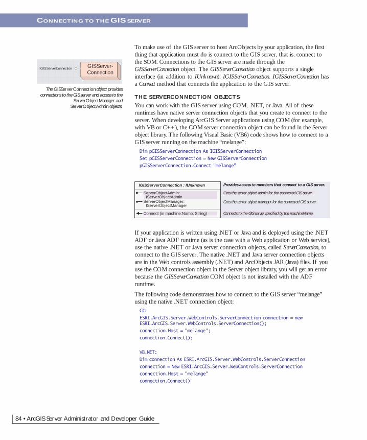
To make use of the GIS server to host ArcObjects by your application, the firstthing that application must do is connect to the GIS server, that is, connect tothe SOM. Connections to the GIS server are made through theGISServerConnection object. The GISServerConnection object supports a singleinterface (in addition to IUnknown): IGISServerConnection. IGISServerConnection hasa Connect method that connects the application to the GIS server.
THE SERVERCONNECTION OBJECTS
You can work with the GIS server using COM, .NET, or Java. All of theseruntimes have native server connection objects that you create to connect to theserver. When developing ArcGIS Server applications using COM (for example,with VB or C++), the COM server connection object can be found in the Serverobject library. The following Visual Basic (VB6) code shows how to connect to aGIS server running on the machine “melange”:Dim pGISServerConnection As IGISServerConnection
Set pGISServerConnection = New GISServerConnection
pGISServerConnection.Connect "melange"
If your application is written using .NET or Java and is deployed using the .NETADF or Java ADF runtime (as is the case with a Web application or Web service),use the native .NET or Java server connection objects, called ServerConnection, toconnect to the GIS server. The native .NET and Java server connection objectsare in the Web controls assembly (.NET) and ArcObjects JAR (Java) files. If youuse the COM connection object in the Server object library, you will get an errorbecause the GISServerConnection COM object is not installed with the ADFruntime.
The following code demonstrates how to connect to the GIS server “melange”using the native .NET connection object:C#:
ESRI.ArcGIS.Server.WebControls.ServerConnection connection = newESRI.ArcGIS.Server.WebControls.ServerConnection();
connection.Host = "melange";
connection.Connect();
VB.NET:
Dim connection As ESRI.ArcGIS.Server.WebControls.ServerConnection
connection = New ESRI.ArcGIS.Server.WebControls.ServerConnection
connection.Host = "melange"
connection.Connect()
The GISServerConnection object providesconnections to the GIS server and access to the
ServerObjectManager andServerObjectAdmin objects.
GISServer-Connection
IGISServerConnection
IGISServerConnection : IUnknown Provides access to members that connect to a GIS server.
ServerObjectAdmin: IServerObjectAdmin
Gets the server object admin for the connected GIS server.
Connects to the GIS server specified by the machineName.
ServerObjectManager: IServerObjectManager
Gets the server object manager for the connected GIS server.
Connect (in machine:Name: String)
CONNECTING TO THE GIS SERVER
Chapter4.pmd 02/16/2005, 10:15 AM84

Chapter 4 • Developing ArcGIS Server applications • 85
The following code demonstrates how to connect to the GISserver “melange” using the native Java connection object:IServerConnection con = new ServerConnection();
con.connect("melange");
If your application is a Web application that uses the ArcGISServer Web controls, the Web controls will connect to theGIS server for you, based on the properties you set for thecontrol. For example, the Map control has properties for theserver name it uses to make the connection.
CONNECTING TO THE GIS SERVER: SECURITY
For a client application to connect to the GIS server, theapplication must be running as an operating system user thatis a member of one of the following two operating systemuser groups defined on the GIS server machines: the ArcGISServer users group (agsusers) or ArcGIS Server administratorsgroup (agsadmin). If the user the application is running as isnot a member of either of those groups, then Connect willreturn an error.
In addition to the Connect method, the IGISServerConnectioninterface has two properties: ServerObjectManager andServerObjectAdmin. If the application is running as a user in
the users or administrators group, the application can access theServerObjectManager property, which returns an IServerObjectManager interface. TheIServerObjectManager interface provides methods for accessing and creating objectswithin the server for use by applications.
To access the ServerObjectAdmin property, the application must be running as auser who is a member of the administrators group. If the connected user is not amember of this group, attempts to access the ServerObjectAdmin property will fail.The ServerObjectAdmin property returns the IServerObjectAdmin interface, whichprovides methods for administering the various aspects of the server, such asserver object configurations and server machines. Unless you are writing a GISserver administration application, your application does not need to make use ofthe IServerObjectAdmin interface.
CONNECTING TO THE GIS SERVER
When applications make connections to the GISserver, they are authenticated against the
agsusers and agsadmin users groups on the GISserver.
` `
GIS Server
agsusers
Cal
Liz
agsadmin
Amelie
Application running as Ameliecan connect with access toServerObjectManager and
ServerObjectAdmin.
Application running as Fred;connection is refused.
Application running as Calcan connect with accessto ServerObjectManager.
Internet
ServerObject-Manager
IServerObjectManager
IServerObjectManager : IUnknown Provides access to properties of, and members to workwith, a GIS server's server object manager.
CreateServerContext (in configName: String, in TypeName: String) : IServerContext
Gets a reference to a server context. The server context can be basedon a specified server object configuration or can be an empty server context if no server object configuration is specified.
GetConfigurationInfo (in Name: String, in TypeName: String) : IServerObjectConfigurationInfo
Gets the information for server object configuration with the specified Name and TypeName.
GetConfigurationInfos: IEnumServerObjectConfigurationInfo
An enumerator over all the GIS server's configuration infos.
GetServerDirectoryInfos: IEnumServerDirectoryInfo
An enumerator over all the GIS server's directory infos.
GetTypeInfos: IEnumServerObjectTypeInfo
An enumerator over all the GIS server's type infos.
The ServerObjectManager object providesmethods for getting information about the GIS
server and for creating server contexts for use byan application.
Chapter4.pmd 02/16/2005, 10:15 AM85

86 • ArcGIS Server Administrator and Developer Guide
ServerObject-Admin
IServerObjectAdminIServerStatistics
The ServerObjectAdmin object providesmethods for administrating the GIS server and
its server objects.
IServerObjectAdmin : IUnknown Provide access to members that administer the GIS server.
Properties: IPropertySet The logging properties for the GIS server.
AddConfiguration (in config: IServerObjectConfiguration)
Adds a server object configuration (created with CreateConfiguration)to the GIS server.
AddMachine (in machine: IServerMachine)
Adds a host machine (created with CreateMachine) to the GIS server.
AddServerDirectory (in pSD: IServerDirectory)
Adds a server directory (created with CreateServerDirectory) to the GIS server.
CreateConfiguration: IServerObjectConfiguration
Creates a new server object configuration.
CreateMachine: IServerMachine Creates a new host machine.CreateServerDirectory: IServerDirectory Creates a new server directory.DeleteConfiguration (in Name: String, in
TypeName: String) Deletes a server object configuration from the GIS server.
DeleteMachine (in machineName: String)
Deletes a host machine from the GIS server, making it unavailable tohost server objects.
DeleteServerDirectory (in Path: String) Deletes a server directory such that its cleanup is no longer managedby the GIS server. It does not delete the physical directory from disk.
GetConfiguration (in Name: String, in TypeName: String) : IServerObjectConfiguration
Get the server object configuration with the specified Name and TypeName.
GetConfigurations: IEnumServerObjectConfiguration
An enumerator over all the server object configurations.
GetConfigurationStatus (in Name: String, in TypeName: String) : IServerObjectConfigurationStatus
Get the configuration status for a server object configuration with thespecified Name and TypeName.
GetMachine (in Name: String) : IServerMachine
Get the host machine with the specified Name.
GetMachines: IEnumServerMachine An enumerator over all the GIS server's host machines.GetServerDirectories:
IEnumServerDirectoryAn enumerator over the GIS server's output directories.
GetServerDirectory (in Path: String) : IServerDirectory
Get the server directory with the specified Path.
GetTypes: IEnumServerObjectType An enumerator over all the server object types.PauseConfiguration (in Name: String, in
TypeName: String) Makes the configuration unavailable to clients for processing requests,
but does not shut down running instances of server objects or interrupt requests in progress.
StartConfiguration (in Name: String, in TypeName: String)
Starts a server object configuration and makes it available to clientsfor processing requests.
StopConfiguration (in Name: String, in TypeName: String)
Stops a server object configuration and shuts down any runninginstances of server objects defined by the configuration.
UpdateConfiguration (in config: IServerObjectConfiguration)
Updates the properties of a server object configuration.
UpdateMachine (in machine: IServerMachine)
Updates the properties of a host machine.
UpdateServerDirectory (in pSD: IServerDirectory)
Updates the properties of a server directory.
When connecting to the server using the native .NET or Java connection objectsfrom a Web application or Web service, you must also think about Web applica-tion impersonation. As discussed in Chapter 2, ‘The ArcGIS Server architecture’,your Web application must connect to the GIS server as a user in the users group.To do this, your Web application must impersonate such a user. If you do not useimpersonation, then your Web application will attempt to connect to the GISserver with the identity of the Web server’s worker process, for example, as theASP.NET user for .NET applications. Impersonation strategies for both .NETand Java are discussed in more detail in Chapter 5, ‘Developing Web applicationswith .NET’, and Chapter 6, ‘Developing Web applications with Java’.
CONNECTING TO THE GIS SERVER
Chapter4.pmd 02/16/2005, 10:15 AM86

Chapter 4 • Developing ArcGIS Server applications • 87
Once connected to the GIS server your application can make use of server ob-jects running within the server and create objects within the server for use by theapplication.
SERVER OBJECTS
A server object is a coarse-grained ArcObjects component that runs in a processon the SOC machine. ArcGIS Server comes with two out-of-the-box serverobjects:
• esriCarto.MapServer
• esriLocation.GeocodeServer
The MapServer object provides access to the contents of a map document andmethods for querying and drawing the map. The GeocodeServer object providesaccess to an address locator and methods for performing single address and batchgeocoding. These coarse-grained MapServer and GeocodeServer objects use the finer-grained ArcObjects on the server to perform mapping and geocoding operations,respectively. Application objects can use the high-level coarse-grained methods onthe MapServer and GeocodeServer object and can also drill down and work with thefine-grained ArcObjects associated with them (feature layers, feature classes,renderers, and so on).
A server object, unlike other ArcObjects components, can be preconfigured by aGIS server administrator. To preconfigure a server object, the GIS server adminis-trator has to set the object’s properties using ArcCatalog before client applicationscan connect and make use of their mapping and geocoding functionality. When aserver object is preconfigured, the administrator must specify a number of con-figuration properties (see Chapters 2 and 3), including the server object’s poolingmodel. The pooling model will dictate the type of usage that an application willmake of the server object. This aspect of server object usage will be discussed inmore detail later when the concept of stateful versus stateless use of the server isdiscussed.
GETTING SERVER OBJECTS FROM THE SERVER
You get a server object by asking the server for a server context containing theobject. You can think of a server context as a process, managed by the server,within which a server object runs. The details of server contexts are discussedlater. Your application keeps a server object alive by holding on to its context,and must release the server object by releasing its context when it is done with it.The following VB6 code is an example of getting a GeocodeServer object from theGIS server and using it to locate an address:Dim pServerContext As IServerContext
Set pServerContext = pSOM.CreateServerContext("RedlandsGeocode","GeocodeServer")
Dim pGCServer As IGeocodeServer
Set pGCServer = pServerContext.ServerObject
Dim pPropertySet As IPropertySet
PROGRAMMING WITH SERVER OBJECTS
MapServer
IMapServerIMapServerData
IMapServerInitIMapServerLayout
IMapServerObjectsIMessageHandlerIObjectConstructIRequestHandler
The MapServer object is a coarse-grained serverobject that provides access to the contents of amap document and methods for querying and
drawing the map.
The GeocodeServer object is a coarse-grainedserver object that provides access to an address
locator and methods for single address and batchgeocoding.
Geocode-Server
IGeocodeServer-Objects
IGeocodeServer
IInitGeocodeServerIMessageHandlerIObjectConstructIRequestHandler
Chapter4.pmd 02/16/2005, 10:15 AM87

88 • ArcGIS Server Administrator and Developer Guide
Set pPropertySet = pServerContext.CreateObject("esriSystem.PropertySet")
pPropertySet.SetProperty "Street", "380 New York St"
Dim pResults As IPropertySet
Set pResults = pGCServer.GeocodeAddress(pPropertySet, Nothing)
Dim pPoint As IPoint
Set pPoint = pResults.GetProperty("Shape")
Debug.Print pPoint.X & ", " & pPoint.Y
pServerContext.ReleaseContext
As discussed earlier, a server object also has other associated objects that a devel-oper can get to and make use of; for example, a developer working with aMapServer object can get to the Map and Layer objects associated with that map.These are the same Map and Layer objects that an ArcGIS Desktop or ArcGISEngine developer would work with, except they reside in the server. The follow-ing VB6 code is an example of using the finer-grained ArcObjects associated witha MapServer object to work with a feature class associated with a particular layer:Dim pServerContext As IServerContext
Set pServerContext = pSOM.CreateServerContext("RedlandsMap", "MapServer")
Dim pMapServer As IMapServer
Set pMapServer = pServerContext.ServerObject
Dim pMapServerObjs As IMapServerObjects
Set pMapServerObjs = pMapServer
Dim pMap As IMap
Set pMap = pMapServerObjs.Map(pMapServer.DefaultMapName)
Dim pFLayer As IFeatureLayer
Set pFLayer = pMap.Layer(0)
Dim pFeatureClass As IFeatureClass
Set pFeatureClass = pFLayer.FeatureClass
Debug.Print pFeatureClass.FeatureCount(Nothing)
pServerContext.ReleaseContext
In the above examples, pSOM is an IServerObjectManager interface that was previ-ously retrieved from IGISServerConnection.ServerObjectManager. You will noticethat when the server object’s work is done and the application is finished usingobjects associated with the server object (in the first case, pPoint, in the secondcase, pFeatureClass), the server context (pServerContext) was explicitly released. It’simportant that the server context is released so other application sessions andother applications can make use of that server object. If your code does notexplicitly release the context, it will be released once it goes out of scope andgarbage collection kicks in. However, there may be a considerable lag between
PROGRAMMING WITH SERVER OBJECTS
Garbage collection is the process by which .NETand Java reclaim memory from objects that arecreated by applications. Garbage collection will
happen based on memory allocations beingmade. When garbage collection occurs is when
objects that are not referenced are actuallycleaned up, which may be some time after they
go out of the scope of your application.
Chapter4.pmd 02/16/2005, 10:15 AM88
Chapter 4 • Developing ArcGIS Server applications • 89
when the server context variable goes out of scope and when garbage collectionkicks in, and if you rely on this mechanism, then your server is at the mercy of.NET or Java garbage collection in terms of when objects are released.
MANAGING SERVER OBJECT LIFETIME
A key aspect of server object usage is managing the server object’s lifetime. Asdescribed previously, server objects live in server contexts, and you get a serverobject by calling CreateServerContext containing a specified server object (seeexamples above).
The server object (for example, RedlandsGeocode, RedlandsMap) and all its associ-ated objects are alive and may be used as long as you hold on to the context.Once you release the server context (by calling ReleaseContext or allowing thecontext to go out of scope), you may no longer make use of the server object orany other objects you obtained from the context. Once a server object’s context isreleased, what happens to the context depends on whether the server object ispooled or non-pooled.
In the non-pooled case, when the context is released, it is shut down by theserver. The next call to CreateServerContext for that server object will create a newinstance of the server object in a new server context. If the server object ispooled, ReleaseContext returns the server object and its context to the pool, andthe server will be free to give the server object to a request from another applica-tion session. This aspect of server object and server context behavior is criticalwhen designing your application and how it manages state. This is discussed in thefollowing section.
PROGRAMMING WITH SERVER OBJECTS
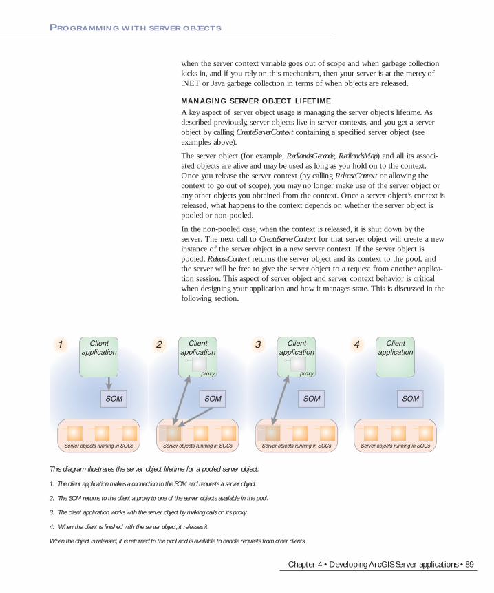
This diagram illustrates the server object lifetime for a pooled server object:
1. The client application makes a connection to the SOM and requests a server object.
2. The SOM returns to the client a proxy to one of the server objects available in the pool.
3. The client application works with the server object by making calls on its proxy.
4. When the client is finished with the server object, it releases it.
When the object is released, it is returned to the pool and is available to handle requests from other clients.
Clientapplication
1
Server objects running in SOCs
SOM
Clientapplication
proxy
2
Server objects running in SOCs
SOM
Clientapplication
proxy
3
Server objects running in SOCs
SOM
Clientapplication
4
Server objects running in SOCs
SOM
Chapter4.pmd 02/16/2005, 10:15 AM89

90 • ArcGIS Server Administrator and Developer Guide
PROGRAMMING WITH SERVER OBJECTS
This diagram illustrates the server object lifetime for a non-pooled server object:
1. The client application makes a connection to the SOM and requests a server object.
2. The SOM creates a new instance of the server object and returns to the client a proxy to the server object.
3. The client application works with the server object by making calls on its proxy.
4. When the client is finished with the server object, it releases it.
When the object is released, it is destroyed. The SOM will create new instances of the server object to handle subsequent requests.
Clientapplication
1
Server objects running in SOCs
SOM
Clientapplication
proxy
2
Server objects running in SOCs
SOM
Clientapplication
proxy
3
Server objects running in SOCs
SOM
Clientapplication
4
Server objects running in SOCs
SOM
Chapter4.pmd 02/16/2005, 10:15 AM90
Chapter 4 • Developing ArcGIS Server applications • 91
One key aspect of designing your application will be whether it is stateful orstateless. You can make either stateful or stateless use of a server object runningwithin the GIS server. Stateless here refers to making read-only use of a serverobject, meaning your application does not make changes to the server object orany of its associated objects. Stateful refers to read–write use of a server objectwhere your application does make changes to the server object or its relatedobjects.
The question of state is important in server object usage because it dictateswhether server objects can be shared across application sessions. If you makestateless use of server objects, then they can be shared across application sessions;if you make stateful use of server objects, then they cannot be shared.
GIS SERVER STATE AND OBJECT POOLING
This aspect of stateful versus stateless use and server object sharing relates di-rectly to the pooling model for the server object. The following pro-gramming rules apply to using server objects:
• Client applications cannot change the properties of a pooled serverobject.
• Client applications can change the properties of a non-pooled serverobject.
Pooled server objects are expected to be used in a stateless manner. As adeveloper, you are responsible for making sure that the state of theserver object, or its associated objects, has not changed when you returnthe object to the pool (by releasing its context via ReleaseServerContext).Each time a user or application session makes a request to create apooled server object, it’s indeterminate which running instance it willget out of the pool; therefore, all instances must have the same state, orapplications will experience inconsistent behavior.
Non-pooled server objects can be used in a stateful manner. Since non-pooled server objects and their contexts are destroyed when you releasethem, you need to hold onto them for as long as the state is important toyou. When you call ReleaseServerContext, or you allow the server contextto go out of scope, the server object and its context are destroyed,purging any state changes you made.
STATEFUL VERSUS STATELESS USE OF SERVER OBJECTS
Methods and properties that are exposed by server object interfaces, such asIMapServer and IGeocodeServer, are by their nature stateless methods, such asIMapServer.ExportMapImage and IGeocodeServer.GeocodeAddress. These methods donot change any of the properties of the server object when they are called andare, therefore, safe to call on both pooled and non-pooled server objects. Chang-ing the state of a server object typically involves making calls to get the finer-grained ArcObjects associated with a server object and making changes at thatlevel.
Most GIS Web applications are not stateless. Typically, each user or session mayhave a current extent, each user or session may have a set of visible layers (thatcan be toggled on and off through the application), and each user or session may
MANAGING APPLICATION SESSION STATE
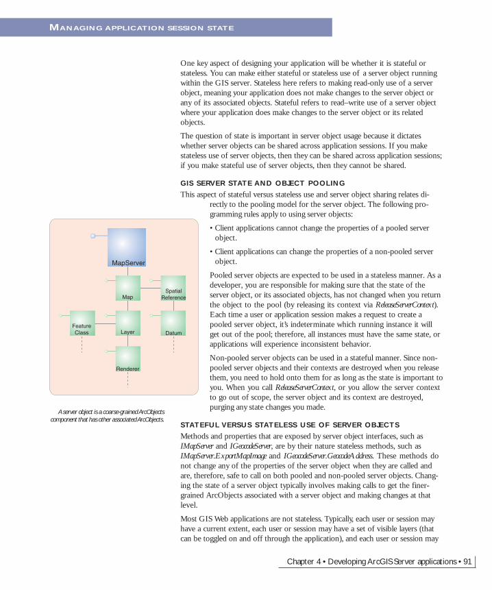
A server object is a coarse-grained ArcObjectscomponent that has other associated ArcObjects.
MapServer
Map
Layer
Renderer
FeatureClass
SpatialReference
Datum
Chapter4.pmd 02/16/2005, 10:15 AM91
92 • ArcGIS Server Administrator and Developer Guide
have different graphics visible on the map as a result of query operations such asnetwork tracing. It is possible to write a stateful Web application that makesstateless use of server objects in the GIS server by maintaining aspects of applica-tion state, such as the extent of the map, layer visibility, and application-addedgraphics, using the Web application server’s session state management capabilities.Such applications are called “shallowly stateful”.
The GIS server also supports “deeply stateful” applications that use the GISserver to maintain application state. Examples of deeply stateful Web applica-tions include:
• An application that starts a geodatabase edit session on behalf of a user andworks with it across multiple requests in a session to support operations suchas undo or redo.
• An application that allows a user to interactively compose a map across mul-tiple requests within a session.
The following code is an example of a stateless use of a MapServer object. In thisexample, a request is made to the MapServer to draw itself at its default extent:Dim pServerContext As IServerContext
Set pServerContext = pSOM.CreateServerContext("RedlandsMap", "MapServer")
Dim pMapServer As IMapServer
Set pMapServer = pServerContext.ServerObject
Dim it As IImageType
Dim idisp As IImageDisplay
Dim pID As IImageDescription
Set it = pServerContext.CreateObject("esriCarto.ImageType")
it.Format = esriImageFormat.esriImageJPG
it.ReturnType = esriImageReturnType.esriImageReturnMimeData
Set idisp = pServerContext.CreateObject("esriCarto.ImageDisplay")
idisp.Height = 400
idisp.Width = 500
idisp.DeviceResolution = 150
Set pID = pServerContext.CreateObject("esriCarto.ImageDescription")
pID.Display = idisp
pID.Type = it
Dim pMD As IMapDescription
Dim pMapServerInfo As IMapServerInfo
Set pMapServerInfo = pMapServer.GetServerInfo(pMapServer.DefaultMapName)
Set pMD = pMapServerInfo.DefaultMapDescription
Dim pMI As IImageResult
Set pMI = pMapServer.ExportMapImage(pMD, pID)
' do something with the image
pServerContext.ReleaseContext
MANAGING APPLICATION SESSION STATE
Chapter4.pmd 02/16/2005, 10:15 AM92

Chapter 4 • Developing ArcGIS Server applications • 93
The following is an example of a stateful use of a MapServer object. In thisexample, the first layer is removed from the map, then a request is made to theMapServer to draw itself at its default extent:Dim pServerContext As IServerContext
Set pServerContext = pSOM.CreateServerContext("RedlandsMap", "MapServer")
Dim pMapServer As IMapServer
Set pMapServer = pServerContext.ServerObject
Dim pMapServerObjs As IMapServerObjects
Set pMapServerObjs = pMapServer
Dim pMap As IMap
Set pMap = pMapServerObjs.Map(pMapServer.DefaultMapName)
pMap.DeleteLayer pMap.Layer(0)
pMapServerObjs.RefreshServerObjects
Dim it As IImageType
Dim idisp As IImageDisplay
Dim pID As IImageDescription
Set it = pServerContext.CreateObject("esriCarto.ImageType")
it.Format = esriImageFormat.esriImageJPG
it.ReturnType = esriImageReturnType.esriImageReturnMimeData
Set idisp = pServerContext.CreateObject("esriCarto.ImageDisplay")
idisp.Height = 400
idisp.Width = 500
idisp.DeviceResolution = 150
Set pID = pServerContext.CreateObject("esriCarto.ImageDescription")
pID.Display = idisp
pID.Type = it
Dim pMD As IMapDescription
Dim pMapServerInfo As IMapServerInfo
Set pMapServerInfo = pMapServer.GetServerInfo(pMapServer.DefaultMapName)
Set pMD = pMapServerInfo.DefaultMapDescription
Dim pMI As IImageResult
Set pMI = pMapServer.ExportMapImage(pMD, pID)
' do something with the image
pServerContext.ReleaseContext
In the first example, no changes were made to the server object or any of itsassociated objects. Once the code finishes executing and the context is released,the server object is in the same state as when the application got it. In the secondexample, a layer was explicitly removed from the map using the DeleteLayer
MANAGING APPLICATION SESSION STATE
Chapter4.pmd 02/16/2005, 10:15 AM93

94 • ArcGIS Server Administrator and Developer Guide
method on the IMap interface. This is an example of using a fine-grainedArcObjects component call to change the state of a server object.
Typically, if you are making state changes to server objects, you would hang on toa reference to its context for the duration of your application session. The aboveexample releases the server context immediately after processing the request. Youwould not do this type of operation with a pooled server object, as subsequentuse of this instance of the MapServer object will reflect the fact that the layer hasbeen removed.
The state of a server object can be changed in a number of different ways. Theexample above demonstrates making direct changes to the properties of a serverobject—for example, removing a layer from a map. It’s also possible to change thestate of a server object indirectly through other objects in the server object’scontext. The following table summarizes the ways that you can change the stateof a server object:
Using a method that is stateful on a server objectA stateful method is one that modifies or changes the instance of the serverobject. There are many examples of stateful methods; some common examplesinclude methods that add or remove layers from a map server object or methodsthat change a layer’s renderer. These methods should never be called on a pooledserver object unless the client application can return the object to its original statebefore releasing it back to the server.
Using a method that is stateful on an environmentServer objects run in contexts that have a number of environment settings associ-ated with them. Some of these environments can be modified by developers. Forexample, the geometry environment can be manipulated through theIGeometryEnvironment interface. While changes to the geometry environment donot directly affect a server object, those changes may affect other operations thata client application may perform using a server object’s context.
The following code is an example of how you can change the state of a serverobject’s environment (in this case, the geometry environment) without directlychanging the server object itself:Dim pServerContext As IServerContext
Set pServerContext = pSOM.CreateServerContext("RedlandsMap", "MapServer")
Dim pGeomEnv As IGeometryEnvironment4
Set pGeomEnv =pServerContext.CreateObject("esriGeometry.GeometryEnvironment")
pGeomEnv.DeviationAutoDensifyTolerance = 5.7
MANAGING APPLICATION SESSION STATE
Call a stateful method on aserver object
� Adding or removing a layer from a map server object � Changing the renderer for a layer in a map server object� Changing the locator properties for a geocode server object
Call a stateful method on anenvironment
� Changing the auto densify tolerance in the geometry environment� Changing the cell size in the raster analysis environment
Stateful operation Example
Chapter4.pmd 02/16/2005, 10:15 AM94

Chapter 4 • Developing ArcGIS Server applications • 95
pGeomEnv.DicingEnabled = True
' perform a geometry operation
pServerContext.ReleaseContext
Changing the state of an environment is valid for both pooled and non-pooledserver object use. To ensure that such changes to environments do not negativelyimpact operations made by client applications, applications should not rely on theenvironment being in a particular state before performing that operation. Whenperforming operations that rely on a particular state of the environment, applica-tions should set the required environment state before performing that operation,especially when using pooled server objects.
Working with cursorsSome objects that you can create in a server context may lock or use resourcesthat the object frees only in its destructor. For example, a geodatabase cursor mayacquire a shared schema lock on a file-based feature class or table on which it isbased or may hold on to an ArcSDE stream.
While the shared schema lock is in place, other applications can continue to queryor update the rows in the table, but they cannot delete the feature class or modifyits schema. In the case of file-based data sources, such as shapefiles, updatecursors acquire an exclusive write lock on the file, which will prevent otherapplications from accessing the file for read or write. The effect of these locks isthat the data may be unavailable to other applications until all of the referenceson the cursor object are released.
In the case of ArcSDE data sources, the cursor holds on to an ArcSDE stream,and if the application has multiple clients, each may get and hold on to anArcSDE stream, eventually exhausting the maximum allowable streams. Theeffect of the number of ArcSDE streams exceeding the maximum is that otherclients will fail to open their own cursors to query the database.
Because of the above reasons, it’s important to ensure that your reference to anycursor your application opens is released in a timely manner. If you are develop-ing your application using Java, when the cursor (or any other COM object) goesout of scope, your reference will be removed immediately for you. If you aredeveloping with .NET, your reference on the cursor (or any other COM object)will not be released until garbage collection kicks in. In a Web application or Webservice that services multiple concurrent sessions and requests, relying on garbagecollection to release references on objects will result in cursors and their resourcesnot being released in a timely manner.
To ensure a COM object is released when it goes out of scope, the WebControlsassembly contains a helper object called WebObject. Use the ManageLifetimemethod to add your COM object to the set of objects that will be explicitlyreleased when the WebObject is disposed. You must scope the use of WebObjectwithin a Using block. When you scope the use of WebObject within a using block,any object (including your cursor) that you have added to the WebObject using theManageLifetime method will be explicitly released at the end of the using block.
MANAGING APPLICATION SESSION STATE
Garbage collection is the process by which .NETand Java reclaim memory from objects that arecreated by applications. Garbage collection will
happen based on memory allocations beingmade. When garbage collection occurs is when
objects that are not referenced are actuallycleaned up, which may be some time after they
go out of the scope of your application.
Chapter4.pmd 02/16/2005, 10:15 AM95

96 • ArcGIS Server Administrator and Developer Guide
The following C# example demonstrates this coding pattern:private void doSomething_Click(object sender, System.EventArgs e)
{
using (WebObject webobj = new WebObject())
{
ServerConnection serverConn = new ServerConnection("doug",true);
IServerObjectManager som = serverConn.ServerObjectManager;
IServerContext ctx =som.CreateServerContext("Yellowstone","MapServer");
IMapServer mapsrv = ctx.ServerObject as IMapServer;
IMapServerObjects mapo = mapsrv as IMapServerObjects;
IMap map = mapo.get_Map(mapsrv.DefaultMapName);
IFeatureLayer flayer = map.get_Layer(0) as IFeatureLayer;
IFeatureClass fclass = flayer.FeatureClass;
IFeatureCursor fcursor = fclass.Search(null, true);
webobj.ManageLifetime(fcursor);
IFeature f = null;
while ((f = fcursor.NextFeature()) != null)
{
// do something with the feature
}
ctx.ReleaseContext();
}
}
VB.NET does not have a Using clause. The following example demonstrates thecoding pattern for VB.NET:Private Sub doSomething_Click(ByVal sender As System.Object, ByVal e AsSystem.EventArgs) Handles doSomething.Click
Dim webobj As WebObject = New WebObject
Dim ctx As IServerContext = Nothing
Try
Dim serverConn As ServerConnection = New ServerConnection("doug",True)
Dim som As IServerObjectManager = serverConn.ServerObjectManager
ctx = som.CreateServerContext("Yellowstone", "MapServer")
Dim mapsrv As IMapServer = ctx.ServerObject
Dim mapo As IMapServerObjects = mapsrv
Dim map As IMap = mapo.Map(mapsrv.DefaultMapName)
Dim flayer As IFeatureLayer = map.Layer(0)
Dim fClass As IFeatureClass = flayer.FeatureClass
Dim fcursor As IFeatureCursor = fClass.Search(Nothing, True)
webobj.ManageLifetime(fcursor)
MANAGING APPLICATION SESSION STATE
Chapter4.pmd 02/16/2005, 10:15 AM96

Chapter 4 • Developing ArcGIS Server applications • 97
Dim f As IFeature = fcursor.NextFeature()
Do Until f Is Nothing
' do something with the feature
f = fcursor.NextFeature()
Loop
Finally
ctx.ReleaseContext()
webobj.Dispose()
End Try
End Sub
The WebMap, WebGeocode, and WebPageLayout objects also have a ManageLifetimemethod. If you are using, for example, a WebMap, and scope your code in a usingblock, you can rely on these objects to explicitly release objects you add withManageLifetime at the end of the using block.
MANAGING STATE IN THE WEB APPLICATION’S SESSION STATE—SHALLOWLY STATEFUL APPLICATIONS
This is not the end of the story when it comes to managingstate of an ArcGIS Server application. As described above,it is possible to write a stateful Web application that makesstateless use of server objects in the GIS server by main-taining aspects of application state, such as the extent ofthe map, layer visibility, and application-added graphics,using the Web application server’s session state managementcapabilities.
The IServerContext interface has methods that allow you tosave GIS objects in session state by exporting them tostrings. The server context also has methods to rehydratethe objects from strings as you need them. Objects thatsupport the IPersistStream interface can be exported andrehydrated in this manner. A very common example illus-trates this capability, which is managing the user’s orsession’s current extent as it pans and zooms around themap.
This programming pattern is demonstrated using anASP.NET example. The following C# code shows how on session startup you cansave references to both the ServerObjectManager and a serialized copy of theMapServer’s map description:private void Page_Load(object sender, System.EventArgs e)
{
// Put user code to initialize the page here
if ( !Page.IsPostBack )
{
// Is this a new session?
if ( Session.IsNewSession )
{
// connect to the server
string m_host = "padisha";
MANAGING APPLICATION SESSION STATE
It is possible to write a stateful Web applicationthat makes stateless use of server objects in theGIS server by maintaining aspects of application
state, such as the extent of the map, layervisibility, and application-added graphics, using the
Web application server’s session state manage-ment capabilities.
Server object
GIS Server
Client application Client application Client application
Chapter4.pmd 02/16/2005, 10:15 AM97
98 • ArcGIS Server Administrator and Developer Guide
ESRI.ArcGIS.Server.WebControls.ServerConnection connection = newESRI.ArcGIS.Server.WebControls.ServerConnection();
connection.Host = m_host;
connection.Connect();
// save a reference to the SOM as an application variable
// called "som" so the connection can be used again later
// in the application
IServerObjectManager som = connection.ServerObjectManager;
Application.Set("som", som);
IServerContext ctx =som.CreateServerContext("RedlandsMap","MapServer");
IMapServer map = ctx.ServerObject as IMapServer;
IMapServerInfo mapinfo = map.GetServerInfo(map.DefaultMapName);
IMapDescription md = mapinfo.DefaultMapDescription;
// save the map description as a session variable called "md"
string sMapDesc = ctx.SaveObject(md);
Session["md"] = sMapDesc;
ctx.ReleaseContext();
}
}
}
The following Java example shows the same programming pattern:public void connect() throws Exception
{
// do only if it is a new session
if (session.isNew())
{
// connect to the server
IServerConnection connection = new ServerConnection();
connection.connect("padisha");
// save a reference to the SOM as an application variable
// called "som" so the connection can be used again later
// in the application
IServerObjectManager som = connection.getServerObjectManager();
session.setAttribute("som",som );
IServerContext ctx =som.createServerContext("RedlandsMap","MapServer");
IMapServer mapServer = new IMapServerProxy(ctx.getServerObject());
IMapServerInfo mapInfo =mapServer.getServerInfo(mapServer.getDefaultMapName());
IMapDescription mapDesc = mapInfo.getDefaultMapDescription();
MANAGING APPLICATION SESSION STATE
The objects and interfaces used for managingimage displays can be found in the Carto objectlibrary. To learn more about these objects, refer
to the online developer documentation.
Chapter4.pmd 02/16/2005, 10:15 AM98
Chapter 4 • Developing ArcGIS Server applications • 99
// save the map description as a session variable called "mxd"
String sMapDesc;
sMapDesc = ctx.saveObject(mapDesc);
session.setAttribute("mapDesc",sMapDesc);
ctx.releaseContext();
}
}
In the code examples above, the MapServer’s MapDescription is being serialized to astring and saved in session state. Assume now that the user for this session wishesto zoom in by a fixed amount. The following code shows how this is done. Thesteps are:
1. Load the serialized map description to get the current map description for thesession.
2. Shrink the extent for the map description.
3. Draw the map using the modified map description.
4. Export the modified map description to a string so that the session state isupdated.
The ASP.NET example of this is illustrated below:private void btnFixedZoomIn_Click(object sender, System.EventArgs e)
{
IServerObjectManager som = (IServerObjectManager)Application.Get("som");
IServerContext ctx = som.CreateServerContext("RedlandsMap","MapServer");
IMapServer map = ctx.ServerObject as IMapServer;
// rehydrate the map description
string smd = (string) Session["md"];
IMapDescription md = ctx.LoadObject(smd) as IMapDescription;
// get the extend, shrink it
IMapArea ma = md.MapArea;
IEnvelope env = ma.Extent;
env.Expand(0.9,0.9,true);
// set the extent into the MapDescription
IMapExtent mx = ma as IMapExtent;
mx.Extent = env;
md.MapArea = ma;
// create ImageDescription and export the map image
IImageType it = ctx.CreateObject("esriCarto.ImageType") as ImageType;
it.Format = esriImageFormat.esriImageJPG;
it.ReturnType = esriImageReturnType.esriImageReturnURL;
IImageDisplay idisp = ctx.CreateObject("esriCarto.ImageDisplay") asIImageDisplay;
MANAGING APPLICATION SESSION STATE
Chapter4.pmd 02/16/2005, 10:15 AM99

100 • ArcGIS Server Administrator and Developer Guide
idisp.Height = 400;
idisp.Width = 500;
idisp.DeviceResolution = 150;
IImageDescription id = ctx.CreateObject("esriCarto.ImageDescription") asIImageDescription;
id.Display = idisp;
id.Type = it;
IImageResult ir = map.ExportMapImage(md,id);
Image1.ImageUrl = ir.URL;
// export map description with the new extent and save it into session state
string sMapDesc = ctx.SaveObject(md);
Session["md"] = sMapDesc;
ctx.ReleaseContext();
}
The following code shows the Java equivalent:public void fixedZoom() throws Exception
{
IServerObjectManager som = (IServerObjectManager)session.getAttribute("mgr");
IServerContext ctx =som.createServerContext("RedlandsMap","MapServer");
IMapServer mapServer = new IMapServerProxy(ctx.getServerObject());
// rehydrate object from xml
String smd = (String) session.getAttribute("mapDesc");
IMapDescription mapDesc = newIMapDescriptionProxy(ctx.loadObject(smd));
// set the new extent
IMapArea ma = mapDesc.getMapArea();
IEnvelope env = ma.getExtent();
env.expand(0.9, 0.9, true);
// apply new extent to the MapDescription
IMapExtent mx = (IMapExtent) ma;
mx.setExtent(env);
mapDesc.setMapArea(ma);
// create ImageDescription and export the map image
IImageType imgType = newIImageTypeProxy(ctx.createObject(ImageType.getClsid()));
imgType.setFormat(esriImageFormat.esriImageJPG);
imgType.setReturnType(esriImageReturnType.esriImageReturnURL);
IImageDisplay imgDisp = newIImageDisplayProxy(ctx.createObject(ImageDisplay.getClsid()));
MANAGING APPLICATION SESSION STATE
Chapter4.pmd 02/16/2005, 10:15 AM100
Chapter 4 • Developing ArcGIS Server applications • 101
imgDisp.setHeight(400);
imgDisp.setWidth(500);
imgDisp.setDeviceResolution(150);
IImageDescription imgDesc = newIImageDescriptionProxy(ctx.createObject(ImageDescription.getClsid()));
imgDesc.setDisplay(imgDisp);
imgDesc.setType(imgType);
IImageResult imgResult = mapServer.exportMapImage(mapDesc,imgDesc);
imgResult.getURL();
// export map description with the new extent and save it into
// session state
String sMapDesc = ctx.saveObject(mapDesc);
session.setAttribute("mapDesc",sMapDesc);
ctx.releaseContext();
}
MANAGING STATE IN THE GIS SERVER—DEEPLY STATEFUL APPLI-CATIONS
The example above is a shallowly stateful application, meaning it is stateful butits state is managed within the Web application server’s session state. The GISserver also supports deeply stateful applications that use the GIS server to main-tain application state.
Supporting such applications requires a server object instance dedicated to eachapplication session. You can configure this by making your server object non-pooled. The fact that server objects necessary for such applications are non-pooled limits the number of concurrent sessions by the processing resources ofthe server.
When programming a deeply stateful Web application, you want to use the sameserver context and server object throughout the session. So, you want to get aserver context at the beginning of the session and hold on to it until the sessionhas ended. The following C# code is an example of how you would obtain anon-pooled server context and add it to your session state in an ASP.NET appli-cation:private void Page_Load(object sender, System.EventArgs e)
{
Session.Timeout = 5;
// Put user code to initialize the page here
if ( !Page.IsPostBack )
{
// Is this a new session?
if ( Session.IsNewSession )
{
// connect to the server
string m_host = "padisha";
MANAGING APPLICATION SESSION STATE
Chapter4.pmd 02/16/2005, 10:15 AM101

102 • ArcGIS Server Administrator and Developer Guide
ESRI.ArcGIS.Server.WebControls.ServerConnection connection = newESRI.ArcGIS.Server.WebControls.ServerConnection();
connection.Host = m_host;
connection.Connect();
IServerObjectManager som = connection.ServerObjectManager;
IServerContext ctx = som.CreateServerContext("Farms","MapServer");
// save the server context as a session variable called "context"
Session["context"] = ctx;
}
}
}
The following C# code shows how you can make use of the server context in thefollowing code, which alters the MapServer by removing the first layer:private void btnDoSomthing_Click(object sender, System.EventArgs e)
{
IServerContext ctx = Session["context"] as IServerContext;
IMapServer map = ctx.ServerObject as IMapServer;
IMapServerObjects mapObj = map as IMapServerObjects;
IMap fgmap = mapObj.get_Map(map.DefaultMapName);
fgmap.DeleteLayer(fgmap.get_Layer(0));
mapObj.RefreshServerObjects();
}
The server context is held on to for the duration of the session and needs to bereleased at the end of the session. The following code shows how to release thecontext when the session ends:protected void Session_End(Object sender, EventArgs e)
{
IServerContext ctx = Session["context"] as IServerContext;
ctx.ReleaseContext();
}
Note that the session ends based on a time-out that is set in the application. Inthis example, the session time-out was set to five minutes, meaning if the userdoes not interact with the running Web application session for five minutes, thenthe session will time out, and the server context will be released by the codeabove. It also means that once a user has ended the session by closing the Webbrowser, the server context will not actually be released for five minutes until thesession time-out is triggered and the code above is executed.
These code examples are illustrations of how you work with server objects whenbuilding applications. It’s important to note that if you are using the Web con-trols to build a Web application, the Web controls take care of many of thesedetails, specifically, the Map control takes care of releasing the server context andtakes care of saving the MapDescription in session state for you. The relationshipbetween Web controls and these aspects of the server API are described in moredetail later.
MANAGING APPLICATION SESSION STATE
Chapter4.pmd 02/16/2005, 10:15 AM102

Chapter 4 • Developing ArcGIS Server applications • 103
APPLICATION STATE AND SCALABILITY
The question of stateful versus stateless use of the GIS server is central to thescalability of your application. An application is more scalable than anotherapplication if it can support a larger number of users with the same amount ofcomputer resources. The keys to scalability are:
• Make stateless use of the GIS server.
• Use pooled server objects.
• Minimize the time your application holds on to a server object. Release serverobjects as soon as possible and do not rely on .NET or Java garbage collectionto do it for you.
Using the above criteria, it’s clear that stateless or shallowly stateful applicationscan make use of object pooling and, therefore, are more scalable than deeplystateful applications. The question of stateful versus stateless use of the GISserver will be critical in designing your application.
This is not the end of performance and scalability when it comes to designingArcGIS Server applications. More discussion on performance tuning of ArcGISServer applications can be found in the ‘ArcGIS Server application performancetuning’ section later in this chapter.
MANAGING APPLICATION SESSION STATE
Chapter4.pmd 02/16/2005, 10:15 AM103

104 • ArcGIS Server Administrator and Developer Guide
To this point, this chapter has focused on the use of server objects to perform thefunctionality that they expose through their coarse-grained interfaces. The ADFsWeb controls’ functionality is based on the functionality exposed by these serverobjects. If you want your application to go beyond simple mapping and geocod-ing using server objects and Web controls, you must become familiar with work-ing with server contexts as well as the ArcObjects programming model.
GETTING AND RELEASING SERVER CONTEXTS
You get a server context using the CreateServerContext method onIServerObjectManager, which hands back an IServerContext interface on the servercontext. The IServerContext interface has a number of methods for helping youmanage the objects you create within server contexts. So far in the code examplesin this chapter the use of three of these methods, specifically CreateObject,SaveObject, and LoadObject, have been shown. The use of these and other methodswill be described in more detail in this section.
IServerObjectManager : IUnknown Provides access to properties of, and members to workwith, a GIS server's server object manager.
CreateServerContext (in configName: String, in TypeName: String) : IServerContext
Gets a reference to a server context. The server context can be basedon a specified server object configuration or can be an empty server context if no server object configuration is specified.
GetConfigurationInfo (in Name: String, in TypeName: String) : IServerObjectConfigurationInfo
Gets the information for server object configuration with the specified Name and TypeName.
GetConfigurationInfos: IEnumServerObjectConfigurationInfo
An enumerator over all the GIS server's configuration info.
GetServerDirectoryInfos: IEnumServerDirectoryInfo
An enumerator over all the GIS server's directory info.
GetTypeInfos: IEnumServerObjectTypeInfo
An enumerator over all the GIS server's type info.
IServerContext : IUnknown Provides access to members for managing a server context and the objects running within that server context.
ServerObject: IServerObject The map or geocode server object running in the server context.
CreateObject (in CLSID: String) : IUnknown Pointer
Create an object in the server context whose type is specified by the CLSID.
GetObject (in Name: String) : IUnknown Pointer
Get a reference to an object in the server context's object dictionary by its Name.
LoadObject (in str: String) : IUnknown Pointer
Create an object in the server context from a string that was created by saving an object using SaveObject.
ReleaseContext Release the server context back to the server so it can be used byanother client (if pooled) or so it can be destroyed (if nonpooled).
Remove (in Name: String) Remove an object from the server context's object dictionary.RemoveAll Remove all objects from the server context's object dictionary.SaveObject (in obj: IUnknown Pointer) :
StringSave an object in the server context to a string.
SetObject (in Name: String, in obj: IUnknown Pointer)
Add an object running in the server context to the context's object dictionary.
When developing applications with ArcGIS Server, all ArcObjects that yourapplication creates and uses live within a server context. A server context is areserved space within the server dedicated to a set of running objects. Serverobjects also reside in a server context. To get a server object, you actually get areference to its context, then get the server object from the context:Dim pServerContext as IServerContext
WORKING WITH SERVER CONTEXTS
ServerContextIServerContext
ServerObject-Manager
IServerObjectManager
The ServerContext object provides access to acontext in the GIS server and methods forcreating and managing objects within that
context.
The ServerObjectManager object providesmethods for getting information about the GIS
server and for creating server contexts for use byan application.
Chapter4.pmd 02/16/2005, 10:15 AM104

Chapter 4 • Developing ArcGIS Server applications • 105
Set pServerContext =pServerObjectManager.CreateServerContext("RedlandsMap","MapServer")
Dim pMapServer as IMapServer
Set pMapServer = pServerContext.ServerObject
You can also create empty server contexts. You can use an empty context tocreate ArcObjects on the fly within the server to do ad hoc GIS processing:Dim IServerContext as IServerContext
Set IServerContext = pServerObjectManager.CreateServerContext("","")
Dim pWorkspaceFactory as IWorkspaceFactory
Set pWorkspaceFactory =pServerContext.CreateObject("esriDataSourcesGDB.SdeWorkspaceFactory")
An empty server context is useful when you want to create objects for yourapplication’s use in the server but do not require the use of a preconfigured serverobject. Empty contexts can be used to create any type of object, such as a con-nection to a workspace as shown above. Since server objects are ArcObjects, youcan also use empty contexts to create server objects (MapServer, GeocodeServer) on-the-fly. Empty server contexts are non-pooled and have high isolation.
When your application is finished working with a server context, it must releaseit back to the server by calling the ReleaseContext method. If you allow the con-text to go out of scope without explicitly releasing it, it will remain in use and beunavailable to other applications until it is garbage collected. Once a context isreleased, the application can no longer make use of any objects in that context.This includes both objects that you may have obtained from or created in thecontext.Dim pServerContext as IServerContext
Set pServerContext =pServerObjectManager.CreateServerContext("RedlandsMap","MapServer")
Dim pMapServer as IMapServer
Set pMapServer = pServerContext.ServerObject
' Do something with the object
pServerContext.ReleaseContext
CREATING OBJECTS IN THE SERVER
Client machines (for example, the Web server machine) require only the ADFruntime be installed to run ArcGIS Server applications. The ADF runtime doesnot install ArcObjects, so these applications do not have the ability to create localArcObjects. All ArcObjects that your application uses should be created within aserver context using the CreateObject method on IServerContext. In previous ex-amples, you have seen CreateObject used to create an ImageDescription object foruse in ExportMapImage.
ArcGIS Server applications written in languages other than Java should not useNew to create local ArcObjects but should always create objects within theserver by calling CreateObject on IServerContext:
Incorrect:Dim pPoint as IPoint
Set pPoint = New Point
WORKING WITH SERVER CONTEXTS
Chapter4.pmd 02/16/2005, 10:15 AM105
106 • ArcGIS Server Administrator and Developer Guide
Correct:Dim pPoint as IPoint
Set pPoint = pServerContext.CreateObject("esriGeometry.Point")
Use CreateObject when you need to create an object for use in your application.Dim pPointCollection as IPointCollection
Set pPointCollection = pServerContext.CreateObject("esriGeometry.Polygon")
CreateObject will return a proxy to the object that is in the server context. Yourapplication can make use of the proxy as if the object was created locally withinits process. If you call a method on the proxy that hands back another object,that object will actually be in the server context, and your application will behanded back a proxy to that object. In the above example, if you get a pointfrom the point collection using IPointCollection::Point, the point returned will be inthe same context as the point collection.
If you add a point to the point collection using IPointCollection::AddPoint, youshould create that point in the same context as the point collection.Dim pPointCollection as IPointCollection
Set pPointCollection = pServerContext.CreateObject("esriGeometry.Polygon")
Dim pPoint as IPoint
Set pPoint = pServerContext.CreateObject("esriGeometry.Point")
pPoint.X = 1
pPoint.Y = 1
pPointCollection.AddPoint pPoint
It’s important to understand how your application is making use of server con-texts as it does its work because objects that are used together should be in thesame context. For example, if you create a point object to use in a spatial selec-tion to query features in a feature class, the point should be in the same contextas the feature class. This becomes important if your application makes use ofmore than one server context. It may be necessary to copy objects from onecontext to another.
Also, you should not directly use objects in a server context with local objects inyour application and vice versa. You can indirectly use objects or make copies ofthem. For example, if you have a Point object in a server context, you can get itsX, Y properties and use them with local objects or use them to create a new localpoint. Don’t directly use the point in the server context as, for example, thegeometry of a local graphic element object.
Consider the following examples. In each example, assume that objects withRemote in their names are objects in a server context as in:Dim pRemotePoint as IPoint
Set pRemotePoint = pServerContext.CreateObject("esriGeometry.Point")
while objects with Local in their name are objects created locally as in:Dim pLocalPoint as IPoint
Set pLocalPoint = New Point
A proxy object is a local representation of aremote object. The proxy object controls accessto the remote object by forcing all interaction
with the remote object to be via the proxyobject. The supported interfaces and methods ona proxy object are the same as those supported
by the remote object. You can make method callson, and get and set properties of, a proxy objectas if you were working directly with the remote
object.
WORKING WITH SERVER CONTEXTS
In Java, use of the New keyword is necessary toavoid a class-cast exception. In this case, the
object returned by the proxy class constructor isactually a reference to the remote object
created on the server by theServerContext.createObject method (see the
‘Java application programming interface’ sectionof Appendix D for more information).
Chapter4.pmd 02/16/2005, 10:15 AM106

Chapter 4 • Developing ArcGIS Server applications • 107
You can’t set a local object to a remote object:' this is incorrect
Set pLocalPoint = pRemotePoint
' this is also incorrect
Set pLocalElement.Geometry = pRemotePoint
Do not set a local object, or a property of a local object, to be an object obtainedfrom a remote object:' this is incorrect
Set pLocalPoint = pRemotePointCollection.Point(0)
When calling a method on a remote object, don’t pass in local objects as param-eters:' this is incorrect
Set pRemoteWorkspace = pRemoteWorkspaceFactory.Open(pLocalPropertySet,0)
You can get simple data types (double, long, string, and so forth) that are passedby value from a remote object and use them as properties of a local object as in:' this is OK
pLocalPoint.X = pRemotePoint.X
pLocalPoint.Y = pRemotePoint.Y
The SaveObject and LoadObject methods allow you to serialize objects in the servercontext to a string, then deserialize them back into objects. You have already seenhow these methods can be used to manage state in your application while makingstateless use of a pooled server object (see previous section). These methods alsoallow you to copy objects between contexts. Any object that supportsIPersistStream can be saved and loaded using these methods. For example, in anapplication that makes use of a MapServer object for mapping and a GeocodeServer
This diagram illustrates the use of SaveObject and LoadObject to copy objects between server contexts:
1. The client application gets or creates an object within a server context.
2. The application uses the SaveObject method on the object’s context to serialize the object as a string that is held in the application’s session state.
3. The client application gets a reference to another server context and calls the LoadObject method, passing in the string created by SaveObject. LoadObject createsa new instance of the object in the new server context.
1
GIS Server
2 3Client application
proxy
Servercontext
Servercontext
GIS Server
Client application
proxy
Servercontext
Servercontext
GIS Server
Client application
proxy proxy
Servercontext
Servercontext
"abc"
WORKING WITH SERVER CONTEXTS
Chapter4.pmd 02/16/2005, 10:15 AM107
108 • ArcGIS Server Administrator and Developer Guide
object for geocoding, the GeocodeServer and MapServer will be running in differentcontexts. If you use the GeocodeServer object to locate an address and you want todraw the resulting point that GeocodeAddress returns on your map, you need tocopy the point into your MapServer’s context:Dim pServerContext as IServerContext
Set pServerContext = pSOM.CreateServerContext("RedlandsMap", "MapServer")
Dim pServerContext2 As IServerContext
Set pServerContext2 = pSOM.CreateServerContext("RedlandsGeocode","GeocodeServer")
Dim pGCServer As IGeocodeServer
Set pGCServer = pServerContext2.ServerObject
Dim pPropertySet As IPropertySet
Set pPropertySet = pServerContext2.CreateObject("esriSystem.PropertySet")
pPropertySet.SetProperty "Street", "380 New York St"
Dim pResults As IPropertySet
Set pResults = pGCServer.GeocodeAddress(pPropertySet, Nothing)
Dim pPoint As IPoint
Set pPoint = pResults.GetProperty("Shape")
' copy the Point to the Map's server context
Dim sPoint As String
sPoint = pServerContext2.SaveObject(pPoint)
Dim pPointCopy As IPoint
Set pPointCopy = pServerContext.LoadObject(sPoint)
pServerContext2.ReleaseContext
' add the point as a graphic to the map description and redraw the map
pServerContext.ReleaseContext
MANAGING OBJECTS IN A SERVER CONTEXT
As your application creates and uses various objects within a particular context,you may want a convenient place to store references to commonly used objectswithin the context. You can do this by using the server context’s object dictionaryto keep track of these objects during the lifetime of the context. You can use thecontext’s dictionary as a convenient place to store objects that you create withinthe context. Note that this dictionary is itself valid only as long as you hold on tothe server context and it’s emptied when you release the context. You can use thisdictionary to share objects created within a context between different parts ofyour application that have access to the context.
WORKING WITH SERVER CONTEXTS
A PropertySet is a generic class that is used tohold any set of properties. A PropertySet’sproperties are stored as name/value pairs.
Examples for the use of a property set are tohold the properties required for opening a
Spatial Database Engine™ (SDE®) workspaceor geocoding an address. To learn more aboutPropertySet objects, see the online developer
documentation.
Chapter4.pmd 02/16/2005, 10:15 AM108

Chapter 4 • Developing ArcGIS Server applications • 109
For example, your application may require a connection to a geodatabase work-space. Since making a geodatabase workspace connection can be expensive, youwould want your application to make the connection once, then store the Work-space object in the context’s dictionary so you can use it multiple times withouthaving to re-create it and, therefore, reconnect to the workspace each time.
You add objects to and retrieve objects from the dictionary using the SetObjectand GetObject methods, respectively. An object that is set in the context will beavailable until it is removed (by calling Remove or RemoveAll) or until the contextis released.Dim pPointCollection as IPointCollection
Set pPointCollection = pServerContext.CreateObject("esriGeometry.Polygon")
pServerContext.SetObject "myPoly", pPointCollection
Dim pPoly as IPolygon
set pPoly = pServerContext.GetObject("myPoly")
Use the Remove and RemoveAll methods to remove an object from a context thathas been set using SetObject. Once an object is removed, a reference to it can nolonger be obtained using GetObject. Note that if you do not explicitly call Removeor RemoveAll, you can still not get references to objects set in the context afterthe context has been released.pServerContext.Remove "myPoly"
WRITING OUTPUT
When your application performs operations using ArcObjects running in servercontexts, those operations may need to write out data to disk. For example, theExportMapImage method on a map server object writes images to disk. You mayhave other applications that need to write data; for example, an application thatcreates geodatabase checkouts needs to write personal geodatabases to disk wherethey can be downloaded from.
Typically, you will want these files to be cleaned up by the server after someperiod of time. To ensure this happens, your applications should write theiroutput to a server directory.
The set of a GIS server’s server directories is available by callingGetServerDirectoryInfos on the IServerObjectManager interface on the server objectmanager. For your files to be cleaned up when written into that server directory,they must follow a file naming convention. The GIS server will delete all files in aserver directory that are prefixed with “_ags_”. Any files written to an outputdirectory that are not prefixed with “_ags_” will not be cleaned by the GISserver.
WORKING WITH SERVER CONTEXTS
IServerDirectoryInfo : IUnknown Provides access to properties of a server output directory.
CleaningMode: esriServerDirectoryCleaningMode
The mode by which the files in the server directory are cleaned (byage, by size, or none).
Description: String The description of the server directory.MaxFileAge: Long The maximum age (in seconds) a file can be in the server directory
before it is deleted, if the cleaning mode is by file age.Path: String The path of the output directory.URL: String The URL of the virtual directory that maps to the physical directory as
described by the Path property.
A server context contains an object dictionarythat serves as a convenient place for you to
store references to commonly used objects. Usethe SetObject and GetObject methods on
IServerContext to work with the objectdictionary.
myWorkspace
myPoint
myProperties
(other)
esriGeodatabase.Workspace
esriGeometry.Point
esriSystem.PropertySet
Chapter4.pmd 02/16/2005, 10:15 AM109
110 • ArcGIS Server Administrator and Developer Guide
The following code shows how you can use the GetServerDirectoryInfos method onIServerObjectManager to get a server directory and create a new personalgeodatabase:Dim pServerContext As IServerContext
Set pServerContext = pSOM.CreateServerContext("", "")
Dim pWSF As IWorkspaceFactory
Set pWSF =pServerContext.CreateObject("esriDataSourcesGDB.AccessWorkspaceFactory")
Dim pEnumSDI As IEnumServerDirectoryInfo
Set pEnumSDI = pSOM.GetServerDirectoryInfos
Dim pSDI As IServerDirectoryInfo
Set pSDI = pEnumSDI.Next
Dim pProps As IPropertySet
Set pProps = pServerContext.CreateObject("esriSystem.PropertySet")
' this database will be cleaned by the GIS server
pProps.SetProperty "DATABASE", pSDI.Path & "\_ags_db1.mdb"
pWSF.Create pSDI.Path, "_ags_db1", pProps, 0
' this database will not be cleaned by the GIS server
pProps.SetProperty "DATABASE", pSDI.Path & "\db2.mdb"
pWSF.Create pSDI.Path, "db2", pProps, 0
WORKING WITH ARCGIS SERVER EXTENSIONS
If your server object container machines have licenses for the Spatial or 3Dextensions for ArcGIS Server, your applications can make use of the functional-ity that is unlocked by that license.
You do not need to do any explicit calls to get a license when you want to use anobject that requires a license. Just create the object on the server and use it. If theserver object container machine is not licensed, then any method calls you makeon the object will fail.
WORKING WITH SERVER CONTEXTS
A PropertySet is a generic class that is used tohold any set of properties. A PropertySet’sproperties are stored as name/value pairs.
Examples for the use of a property set are tohold the properties required for opening an SDE
workspace or geocoding an address. To learnmore about PropertySet objects, see the online
developer documentation.
This code creates two geodatabases, one namedsuch that it will be cleaned by the GIS server,
one named such that it will not be cleaned bythe GIS server.
Chapter4.pmd 02/16/2005, 10:15 AM110
Chapter 4 • Developing ArcGIS Server applications • 111
In many cases, you will be building Web applications that make use of the GISserver through the Web controls. To build sophisticated GIS applications that gobeyond the functionality exposed by the Web controls, it’s important to under-stand both the server programming model as discussed in this chapter and therelationship between the server API and the Web controls API.
There are two key points that are important to discuss with respect to Webcontrols and the server API:
• Management of session state
• Management of server contexts for pooled and non-pooled server objects
The Web controls are described in much more detail in Chapter 5, ‘DevelopingWeb applications with .NET’, and Chapter 6, ‘Developing Web applications withJava’. The information presented here does not preclude the need to understandthe material presented in those chapters.
WEB CONTROLS AND SESSION STATE
The WebMap (.NET) or AGSWebContext (Java) object of the map and overviewmap controls manages the MapDescription of the MapServer object in session statefor you. When you use methods on WebMap or AGSWebContext, such as Zoom,Pan, and CenterAt, to navigate the map, WebMap or AGSWebContext internallyuses SaveObject and LoadObject as described previously to maintain stateful aspectsof the application, such as current extent, within session state. The page layoutcontrol’s WebPageLayout (.NET) or AGSWebContext (Java) object does the samefor the PageDescription and collection of MapDescriptions associated with theMapServer’s page layout. The TOC control has methods for turning the visibilityof layers displayed in a map control on and off. Like the WebMap andWebPageLayout (.NET) and AGSWebContext (Java), using the methods on the TOCcontrol to turn layers on and off will update the session’s copy of theMapDescription.
If you want to manipulate the MapDescription yourself, for example, to addgraphics to the map, you can ask the WebMap or AGSWebContext for itsMapDescription, in which case you will be manipulating the copy of the mapdescription that the WebMap or AGSWebContext is managing in session state foryou.
WEB CONTROLS AND SERVER CONTEXT MANAGEMENT
The WebMap (.NET) or AGSWebContext (Java) object also manages the acquiringand releasing of server contexts. The remainder of this section will illustrate thisconcept using the .NET case (WebMap within an ASP.NET application). ForJava-specific examples of how the AGSWebContext does this, see Chapter 6,‘Developing Web applications with Java’.
If you scope the use of the WebMap within a Using block, the WebMap will get aserver context from the server at the beginning of the Using block, then explic-itly release it.
The following code is an example of using the WebMap in a Using block to usethe MapServer’s context to count the number of features in the first layer of themap that intersect the current extent:using (WebMap webMap = Map1.CreateWebMap())
WEB CONTROLS AND THE SERVER API
Chapter4.pmd 02/16/2005, 10:15 AM111

112 • ArcGIS Server Administrator and Developer Guide
{
IMapServer map = webMap.MapServer;
IMapServerObjects mapso = map as IMapServerObjects;
IMap fgmap = mapso.get_Map(map.DefaultMapName);
IFeatureLayer fl = fgmap.get_Layer(0) as IFeatureLayer;
IFeatureClass fc = fl.FeatureClass;
IServerContext sctx = webMap.ServerContext;
ISpatialFilter sf = sctx.CreateObject("esriGeoDatabase.SpatialFilter")as ISpatialFilter;
IMapDescription md = webMap.MapDescription;
IMapArea ma = md.MapArea;
sf.SpatialRel = esriSpatialRelEnum.esriSpatialRelIntersects;
sf.Geometry = ma.Extent as IGeometry;
sf.GeometryField = fc.ShapeFieldName;
long lcount = fc.FeatureCount(sf);
}
This example is valid to use for either a pooled or non-pooled server object sinceit does not change the state of any aspects of the server object and does not saveany objects for later use in the server’s context.
When the Map control’s ServerObject property is set to be a pooled server object,when you get the WebMap from the Map control using the CreateWebMapmethod, the Map control is internally using CreateServerContext to create a newserver context using the ServerObject property of the Web control to create aserver context for the appropriate MapServer object. When the WebMap goes outof scope, the Map control internally calls ReleaseContext to release the context.The methods exposed by the Web controls are stateless, so a server object’s stateis never altered by calling one of the methods on a Web control.
When the Map control’s ServerObject property is set to be a non-pooled serverobject, the Map control will create a server context at the beginning of thesession and hold on to the same server context for the entire session.CreateWebMap uses the context already in session, and when the WebMap goes outof scope, the context is not released.
The next example uses the WebMap with a non-pooled server object to get areference to the Workspace for a layer in the map and store that workspace objectin the context’s object dictionary. Since it is a non-pooled server object, the nexttime the WebMap is obtained from the Map control, it will be the same context.The following code would go in the Page_Load event of the application:using (WebMap webMap = Map1.CreateWebMap() )
{
// get the workspace from the first layer and add it to the context'sobject dictionary
IMapServerObjects mapo = (IMapServerObjects) webMap.MapServer;
IMap map = mapo.get_Map(webMap.DataFrame);
WEB CONTROLS AND THE SERVER API
The objects and interfaces used for creating andworking with geometries can be found in theGeometry object library. To learn more about
geometry objects, see the online developerdocumentation.
The objects and interfaces used for performingspatial queries and for working with the results
of those queries can be found in theGeoDatabase object library. To learn more about
geodatabase objects, see the online developerdocumentation.
Chapter4.pmd 02/16/2005, 10:15 AM112
Chapter 4 • Developing ArcGIS Server applications • 113
// get workspace from first layer and add it to the object dictionary
IFeatureLayer fl = (IFeatureLayer) map.get_Layer(0);
IDataset ds = (IDataset) fl.FeatureClass;
IWorkspaceEdit wse = (IWorkspaceEdit) ds.Workspace;
IServerContext sc = webMap.ServerContext;
sc.SetObject("theWS",wse);
}
Once the session ends, you must make sure that server context is released bylooping through all of the Web controls and explicitly releasing their contexts:protected void Session_End(Object sender, EventArgs e)
{
IServerContext context;
for ( int i = 0; i < Session.Count; i++)
{
context = Session[i] as IServerContext;
if ( context != null )
context.ReleaseContext();
}
Session.RemoveAll();
}
It’s important to note that if you create any additional contexts within the Usingblock, it is still your responsibility to call ReleaseContext on them. WebMap willonly release the context that it creates.
There is more complete documentation on using the Web controls in Chapter 5,‘Developing Web applications with .NET’, and Chapter 6, ‘Developing Webapplications with Java’.
WEB CONTROLS AND THE SERVER API
Chapter4.pmd 02/16/2005, 10:15 AM113
114 • ArcGIS Server Administrator and Developer Guide
One aspect of programming ArcGIS Server is to create GIS Web applicationsthat run in a browser and that people interact with. Developers can also useArcGIS Server to create GIS Web services. Unlike a Web application, a Webservice is a program that is used by other programs and not users directly. Thetypes of Web services that ArcGIS Server supports can be divided into twocategories: application Web services and ArcGIS Server Web services.
APPLICATION WEB SERVICES
A Web service is a set of related application functions that can be programmati-cally invoked over the Internet. An application Web service solves a particularproblem, for example, a Web service that finds all of the hospitals within acertain distance of an address or performs some other type of GIS analysis.Application Web services can be implemented using the native Web serviceframework of your Web server, for example, ASP.NET Web service(WebMethod) or Java Web service (Axis).
When using native frameworks, such as ASP.NET and J2EE, to create and con-sume your application Web services, you need to use native or application-definedtypes as both arguments and return values from your Web methods. Clients of theWeb service will not be ArcObjects applications, and as such, your Web serviceshould not expect ArcObjects types as arguments and should not directly returnArcObjects types.
Any development language that can use standard HTTP to invoke methods canconsume a Web service. The Web service consumer can get the methods and typesexposed by the Web service through its Web Service Description Language(WSDL).
The following is a simple example of a geocoding Web service written usingASP.NET, which connects to the ArcGIS Server and makes use of a GeocodeServerobject to locate the address. Notice that its arguments are strings (an address anda ZIP Code), and it does not return an ArcObjects point object but returns the xand y coordinates of the point as a string:[WebMethod]
public string LocateAddr(string address, string zipcode)
{
string wsresult = "";
if (address == null || zipcode == null)
return wsresult;
// connect to the GIS server
string m_host = "padisha";
ESRI.ArcGIS.Server.WebControls.ServerConnection connection = newESRI.ArcGIS.Server.WebControls.ServerConnection();
connection.Host = m_host;
connection.Connect();
// get a server context
IServerObjectManager som = connection.ServerObjectManager;
PROGRAMMING WEB SERVICES
To learn more about WSDL, refer to http://www.w3.org.
Chapter4.pmd 02/16/2005, 10:15 AM114
Chapter 4 • Developing ArcGIS Server applications • 115
IServerContext sc =som.CreateServerContext("RedlandsGC","GeocodeServer");
try
{
IServerObject so = sc.ServerObject;
IGeocodeServer gc = (IGeocodeServer)so;
IPropertySet ps =(IPropertySet)sc.CreateObject("esriSystem.PropertySet");
ps.SetProperty("street",address);
ps.SetProperty("Zone",zipcode);
IPropertySet res = gc.GeocodeAddress(ps,null);
ESRI.ArcGIS.Geometry.IPoint tempPt = (ESRI.ArcGIS.Geometry.IPoint)res.GetProperty("Shape");
wsresult = tempPt.X + "," + tempPt.Y;
// release the server context
sc.ReleaseContext();
}
catch
{
// release the server context
sc.ReleaseContext();
}
return wsresult;
}
Notice in the code above, all the standard aspects of programming with theArcGIS Server API apply, including connecting to the server, working with serverobjects and server contexts, and releasing the server context at the end of themethod. The following C# code is an example of a client to this Web service. Inthis example, wsref is the name of the Web reference made to this Web service:wsref.FindAddress w = new wsref.FindAddress();
string slocation = w.LocateAddr("380 New York St","92373");
An application Web service is built by application developers, using native .NETor J2EE Web service frameworks. The Web service is processed and executedwithin the Web server and makes calls into the GIS server for GIS functionality.
PROGRAMMING WEB SERVICES
Chapter4.pmd 02/16/2005, 10:15 AM115
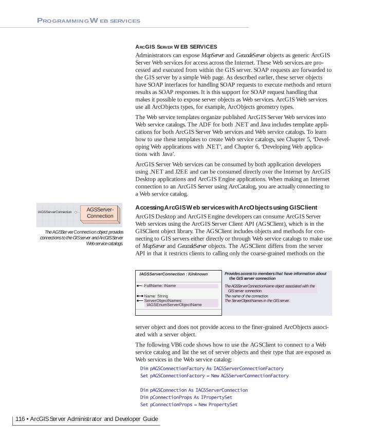
116 • ArcGIS Server Administrator and Developer Guide
ARCGIS SERVER WEB SERVICES
Administrators can expose MapServer and GeocodeServer objects as generic ArcGISServer Web services for access across the Internet. These Web services are pro-cessed and executed from within the GIS server. SOAP requests are forwarded tothe GIS server by a simple Web page. As described earlier, these server objectshave SOAP interfaces for handling SOAP requests to execute methods and returnresults as SOAP responses. It is this support for SOAP request handling thatmakes it possible to expose server objects as Web services. ArcGIS Web servicesuse all ArcObjects types, for example, ArcObjects geometry types.
The Web service templates organize published ArcGIS Server Web services intoWeb service catalogs. The ADF for both .NET and Java includes template appli-cations for both ArcGIS Server Web services and Web service catalogs. To learnhow to use these templates to create Web service catalogs, see Chapter 5, ‘Devel-oping Web applications with .NET’, and Chapter 6, ‘Developing Web applica-tions with Java’.
ArcGIS Server Web services can be consumed by both application developersusing .NET and J2EE and can be consumed directly over the Internet by ArcGISDesktop applications and ArcGIS Engine applications. When making an Internetconnection to an ArcGIS Server using ArcCatalog, you are actually connecting toa Web service catalog.
Accessing ArcGIS Web services with ArcObjects using GISClientArcGIS Desktop and ArcGIS Engine developers can consume ArcGIS ServerWeb services using the ArcGIS Server Client API (AGSClient), which is in theGISClient object library. The AGSClient includes objects and methods for con-necting to GIS servers either directly or through Web service catalogs to make useof MapServer and GeocodeServer objects. The AGSClient differs from the serverAPI in that it restricts clients to calling only the coarse-grained methods on the
server object and does not provide access to the finer-grained ArcObjects associ-ated with a server object.
The following VB6 code shows how to use the AGSClient to connect to a Webservice catalog and list the set of server objects and their type that are exposed asWeb services in the Web service catalog:Dim pAGSConnectionFactory As IAGSServerConnectionFactory
Set pAGSConnectionFactory = New AGSServerConnectionFactory
Dim pAGSConnection As IAGSServerConnection
Dim pConnectionProps As IPropertySet
Set pConnectionProps = New PropertySet
AGSServer-Connection
IAGSServerConnection
IAGSServerConnection : IUnknown Provides access to members that have information about the GIS server connection
FullName: IName The AGSServerConnectionName object associated with the GIS server connection.
Name: String The name of the connection.ServerObjectNames:
IAGSEnumServerObjectNameThe ServerObjectNames in the GIS server.
The AGSServerConnection object providesconnections to the GIS server and ArcGIS Server
Web service catalogs.
PROGRAMMING WEB SERVICES
Chapter4.pmd 02/16/2005, 10:15 AM116
Chapter 4 • Developing ArcGIS Server applications • 117
pConnectionProps.SetProperty "URL", "http://padisha/redlandscatalog/default.aspx"
Set pAGSConnection = pAGSConnectionFactory.Open(pConnectionProps, 0)
Dim pEnumSOName As IAGSEnumServerObjectName
Set pEnumSOName = pAGSConnection.ServerObjectNames
Dim pSOName As IAGSServerObjectName
Set pSOName = pEnumSOName.Next
Do Until pSOName Is Nothing
Debug.Print pSOName.Name & ": " & pSOName.Type
Set pSOName = pEnumSOName.Next
Loop
The GISClient objects can be used to connect to a GIS server either via a LANconnection (by specifying the machine property in the connection) or via a Webservice catalog (by providing the URL property in the connection). TheGISClient object provides a uniform programming interface for working withserver objects through both LAN connections and Web service connections.
The following VB6 code shows how to use the AGSClient to connect to the GISserver directly running on the machine “melange” and list the set of server objectsand their type that are running in the GIS server:Dim pAGSConnectionFactory As IAGSServerConnectionFactory
Set pAGSConnectionFactory = New AGSServerConnectionFactory
Dim pAGSConnection As IAGSServerConnection
Dim pConnectionProps As IPropertySet
Set pConnectionProps = New PropertySet
pConnectionProps.SetProperty "machine", "melange"
Set pAGSConnection = pAGSConnectionFactory.Open(pConnectionProps, 0)
Dim pEnumSOName As IAGSEnumServerObjectName
Set pEnumSOName = pAGSConnection.ServerObjectNames
Dim pSOName As IAGSServerObjectName
Set pSOName = pEnumSOName.Next
Do Until pSOName Is Nothing
Debug.Print pSOName.Name & ": " & pSOName.Type
Set pSOName = pEnumSOName.Next
Loop
You can make stateless use of server objects that you get from a GISClient con-nection and call methods exposed by the server object’s stateless interfaces;however, you cannot use a server object obtained via GISClient to drill down tothe finer-grained ArcObjects associated with the server object. You can get areference to the ServerObjectManager through the GISClient connection, provided
PROGRAMMING WEB SERVICES
Chapter4.pmd 02/16/2005, 10:15 AM117
118 • ArcGIS Server Administrator and Developer Guide
that connection is a LAN connection. You can then use the methods exposed bythe ServerObjectManager to obtain references to server contexts and server objectsto work with the server API.
Accessing ArcGIS Server Web services directlyArcGIS Server Web services, similar to application Web services, can be accessedby any development language that can submit SOAP-based requests to a Webservice and process SOAP-based responses. The Web service consumer can get themethods and types exposed by the Web service through its WSDL. ArcGIS Webservices are based on the SOAP doc/literal format and are interoperable acrossJava and .NET.
On the Web server, the Web service catalog templates can be used by developersto publish any server object as a Web service over HTTP. For any published serverobject, the template creates an HTTP endpoint (URL) to which SOAP requestscan be submitted using the standard HTTP POST method. The endpoint alsosupports returning the WSDL for the Web service using a standard HTTP GETmethod with “wsdl” as the query string. The implementation of the HTTP end-point is thin, while the actual processing of the SOAP request and the generationof the SOAP response take place within the GIS server. The WSDLs that de-scribe the definitions of the SOAP requests and responses are also part of theGIS server and are installed as part of the ArcGIS Server install under <installdirectory>\XMLSchema.
The Web service templates organize published ArcGIS Server Web services intoWeb service catalogs. Each Web service is a distinct HTTP endpoint/URL. TheWeb service catalog is itself a Web service with a distinct endpoint and can bequeried to obtain the list of Web services in the catalog and the URL for eachWeb service in the catalog.
The types of Web services supported at version 9.0 are:
• Web service catalog
• MapServer
• GeocodeServer
Each Web service has its own WSDL.
The Web service templates are available for use on both .NET and Java Webservers and create identical endpoints. To a consumer of the Web services, thetwo different server implementations are identical in terms of WSDLs and howone obtains the WSDLs and interacts with the Web service over HTTP.
For example, assume that the ArcGIS Server administrator or developer at anorganization named ACME, whose .NET Web server has the URL http://www.myserver.com, has used the ArcGIS Server Web service catalog templates tocreate a Web service catalog called “MyCatalog”, which contains a MapServerWeb service named “PortlandMap” and a GeocodeServer Web service“PortlandGeocode”. The URLs for the Web services are:
Web service catalog:http://www.myserver.com/MyCatalog/Default.aspx
PROGRAMMING WEB SERVICES
Chapter4.pmd 02/16/2005, 10:15 AM118

Chapter 4 • Developing ArcGIS Server applications • 119
PROGRAMMING WEB SERVICES
Portland map server:http://www.myserver.com/MyCatalog/PortlandMap.aspx
Portland geocode server:http://www.myserver.com/MyCatalog/PortlandGeocode.aspx
If the ArcGIS Server site was running a Java Web server, then the URLs wouldbe:
Web service catalog:http://www.myserver.com/MyCatalog/Default.jsp
Portland map server:http://www.myserver.com/MyCatalog/PortlandMap.jsp
Portland geocode server:http://www.myserver.com/MyCatalog/PortlandGeocode.jsp
ArcGIS Web services can be consumed from .NET or Java. As a consumer of anArcGIS Web service, you can use the methods exposed by the Web service byincluding a reference to the Web service in your .NET or Java project. Webservices implemented on a Java Web server can be consumed from a .NET clientand vice versa.
Assume you are a .NET developer who wishes to consume the above Web ser-vices published by ACME. You can add the following references to your VisualStudio .NET project:
ServiceCatalog:http://www.myserver.com/MyCatalog/Default.aspx?wsdl
Portland MapServer Web service:http://www.myserver.com/MyCatalog/PortlandMap.aspx?wsdl
Portland GeocodeServer Web service:http://www.myserver.com/MyCatalog/PortlandGeocode.aspx?wsdl
The following C# code is an example of using an ArcGIS Server MapServer Webservice to draw a map. In this example the Portland Web service has been refer-enced as Port:Port.Portland map = new Port.Portland ();
Port.MapServerInfo mapi = map.GetServerInfo(map.GetDefaultMapName());
Port.MapDescription pMapDescription = mapi.DefaultMapDescription;
Port.ImageType it = new Port.ImageType();
it.ImageFormat = Port.esriImageFormat.esriImageBMP;
it.ImageReturnType = Port.esriImageReturnType.esriImageReturnMimeData;
Port.ImageDisplay idisp = new Port.ImageDisplay();
idisp.ImageHeight = 400;
idisp.ImageWidth = 500;
idisp.ImageDPI = 150;
Port.ImageDescription pID = new Port.ImageDescription();
pID.ImageDisplay = idisp;
pID.ImageType = it;
Chapter4.pmd 02/16/2005, 10:15 AM119
120 • ArcGIS Server Administrator and Developer Guide
Port.MapImage pMI = map.ExportMapImage(pMapDescription, pID);
System.IO.Stream pStream = newSystem.IO.MemoryStream((byte[])pMI.ImageData);
System.Drawing.Image pImage = Image.FromStream(pStream);
The following C# code is an example of using an ArcGIS Server GeocodeServerWeb service to locate an address and get the x and y location of the resultingpoint. In this example the PortlandGeocode Web services has been referenced asPortGC:PortGC.PortlandGC gc = new PortGC.PortlandGC();
PortGC.PropertySet ps = new PortGC.PropertySet();
PortGC.PropertySetProperty[] pa = new PortGC.PropertySetProperty[2];
PortGC.PropertySetProperty pr = new PortGC.PropertySetProperty();
pr.Key = "street";
pr.Value = "2111 division st";
pa[0] = pr;
PortGC.PropertySetProperty pr2 = new PortGC.PropertySetProperty();
pr2.Key = "zone";
pr2.Value = "97202";
pa[1] = pr2;
ps.PropertyArray = pa;
PortGC.PropertySet resps = gc.GeocodeAddress(ps,null);
PortGC.PropertySetProperty[] respa = resps.PropertyArray;
PortGC.Point pnt = null;
for (int i = 0;i < respa.Length;i++)
{
if (respa[i].Key == "Shape")
pnt = respa[i].Value as PortGC.Point;
break;
}
double X = pnt.X;
double Y = pnt.Y;
The following C# code is an example of using an ArcGIS Server Service CatalogWeb service to query the URLs of the Web services in the Web service catalog. Inthis example the Web service catalog has been referenced as WSCat:WSCat.Default sc = new WSCat.Default();
WSCat.ServiceDescription[] wsdesc = sc.GetServiceDescriptions();
WSCat.ServiceDescription sd = null;
string wsURL = null;
for (int i = 1;i < wsdesc.Length;i++)
{
sd = wsdesc[i];
wsURL = sd.Url;
// do something with the URL
}
PROGRAMMING WEB SERVICES
Chapter4.pmd 02/16/2005, 10:15 AM120

Chapter 4 • Developing ArcGIS Server applications • 121
As discussed in the previous sections, developing ArcGIS Server applications is allabout remotely programming ArcObjects. As such, the server API is wide andincludes a large number of ArcObjects components organized into a series ofobject libraries. Developers can build any kind of application using the serverAPI, so it is possible to build high-performance, scalable applications, and it isalso possible to build extremely slow applications that do not scale.
This section will discuss strategies for avoiding the latter, but it will ultimately bein the hands of the developer and the GIS server administrator to work togetherto design applications that can perform and scale given available hardware re-sources.
ARCGIS SERVER AND FINE-GRAINED ARCOBJECTS
ArcGIS Server uses the same ArcObjects that ArcGIS Engine and ArcGISDesktop use, so if your server application includes GIS functionality that per-forms poorly in an ArcGIS Engine or ArcGIS Desktop deployment, that samefunctionality will likely perform poorly in your server deployments. Conversely, ifthat GIS functionality performs well in an ArcGIS Engine or Desktop deploy-ment, it will also perform well in server deployments if the application is prop-erly tuned with respect to how it makes use of ArcObjects in the server.
Both coarse-grained calls to remote ArcObjects, such as the methods on theMapServer and GeocodeServer, and fine-grained calls to remote ArcObjects, such aslooping through all the vertices of a polygon, are exposed through the ArcGISServer API and can be used in your application. However, it’s important to notethat when making a call against an object running in the server from your Webapplication, you are making that call across processes. The Web server is runningin one process, while the object is running in another process.
Calls to objects across processes are significantly slower than calls to objects in thesame process. It is also likely that your Web application is running on a Webserver that is actually a different machine from which the object is running on, sothe calls are not only cross process, but also cross machine. This performancedifference on the scale of a single call or a few tens of calls is not significant interms of the overall performance of your application. However, if your applica-tion is making thousands of fine-grained ArcObjects calls across process or ma-chine to the server, there can be a significant performance impact on the applica-tion.
You should minimize the number of round-trips to the GIS server from yourapplication by minimizing the number of fine-grained calls to remote objects. Ifthe nature of your application demands a lot of fine-grained ArcObjects work,one strategy for supporting such functionality, but keeping remote calls to aminimum, is to extend the GIS server with application-specific utility COMobjects that you can develop in VB, C++, or .NET.
EXTENDING THE GIS SERVER
The GIS server can easily be extended to use application-specific utility COMobjects that a developer can write in VB, C++, or .NET. If these COM compo-nents are installed on the server object container machines on which your serverobjects are hosted, they can be used to do work for your application. For ex-
The GIS server can easily be extended to useapplication-specific COM objects that a developer
can write in VB, C++, or .NET. If these COMcomponents are installed on the server object
container machines on which your server objectsare hosted, then they can be used to do work for
your application.
Client application
proxies Utility COMobject proxy
GIS ServerServer context
Utility COMobject
ARCGIS SERVER APPLICATION PERFORMANCE TUNING
Chapter4.pmd 02/16/2005, 10:15 AM121
122 • ArcGIS Server Administrator and Developer Guide
ample, you may have a custom network tracing function that you want to use inyour server application. You can write the tracing code as a COM object andinstall it on the server:mylib.TraceUtilities tracer =pServerContext.CreateObject("mylib.TraceUtilities") asmylib.TraceUtilities;
result = tracer.DoIsolationTrace(...)
In this example, the tracing function may involve thousands of ArcObjects calls,but all of those calls happen in the server where the TraceUtilities COM object isrunning. The coarse-grained DoIsolationTrace method is the only method that theWeb application needs to call, which means there is only a single remote objectcall to the server.
To illustrate this in more detail, here is a simple ASP.NET example in which aWeb application includes a button (btnTotalAreas) that reports the total area ofpolygon features in one of the map’s layers that intersect the map extent anddisplays the result on a label on the Web form (lblResult). In this example, theWeb application includes a Map control (Map1), from which it gets the MapServerand its server context, and includes a TOC control (Toc1) that the user of theWeb application uses to identify which layer to query.
To do the above, a spatial query is made on the selected layer’s feature class usingthe map’s current extent to return a geodatabase cursor. The application thenloops through the cursor, gets each feature’s geometry, and adds its area to thetotal. The following is the C# code that would execute when the button isclicked:private void btnTotalAreas_Click(object sender, System.EventArgs e)
{
using (WebMap webMap = Map1.CreateWebMap() )
{
IMapServer map = webMap.MapServer;
IServerContext ctx = webMap.ServerContext;
IMapServerObjects mapobj = map as IMapServerObjects;
IMap fgmap = mapobj.get_Map(map.DefaultMapName);
// find the selected layer
IEnumLayer maplayers = fgmap.get_Layers(null,true);
ILayer lyr;
string sLayername =Toc1.GetNodeFromIndex(Toc1.SelectedNodeIndex).Text;
while ((lyr = maplayers.Next()) != null)
{
if (lyr.Name == sLayername)
break;
}
if (lyr == null)
{
lblResult.Text = "Layer not found";
ARCGIS SERVER APPLICATION PERFORMANCE TUNING
Chapter4.pmd 02/16/2005, 10:15 AM122

Chapter 4 • Developing ArcGIS Server applications • 123
return;
}
// get the feature class and make sure its geometry type is polygon
IFeatureLayer flyr = lyr as IFeatureLayer;
IFeatureClass fc = flyr.FeatureClass;
if (fc.ShapeType != esriGeometryType.esriGeometryPolygon)
{
lblResult.Text = "Select a polygon layer";
return;
}
// create the query using the current extent of the map
ISpatialFilter sf = ctx.CreateObject("esriGeoDatabase.SpatialFilter")as ISpatialFilter;
IMapArea ma = webMap.MapDescription.MapArea;
sf.SpatialRel = esriSpatialRelEnum.esriSpatialRelIntersects;
sf.GeometryField = fc.ShapeFieldName;
sf.Geometry = ma.Extent as IGeometry;
// execute the query and loop through the results
IFeature f;
IArea area;
double dTotalArea = 0.0;
IFeatureCursor fcursor = fc.Search(sf,true);
while ((f = fcursor.NextFeature()) != null)
{
area = f.Shape as IArea;
dTotalArea += area.Area;
}
lblResult.Text = dTotalArea.ToString();
}
}
This code makes approximately eight remote calls on ArcObjects running on theserver to get the map from the MapServer, get the layers from the map, find theselected layer, check to verify that it is a polygon layer, then create the QueryFilterand set its properties. These fine-grained calls into the server do not add up to anysignificant amount of time.
However, once the query has been executed, three calls are made to the serverper feature: one to get the feature, one to get its geometry, and one to get thegeometry’s area. If you consider that (based on the way this application is writ-ten) the number of features that may result from the query is indeterminate, theapplication could potentially loop through thousands of features. If there are1,000 features intersecting the map extent, then this translates into 3,000 fine-grained calls into the server.
The cost of this number of fine-grained calls does add up and can cause theperformance of your application to suffer. To minimize or eliminate this large
ARCGIS SERVER APPLICATION PERFORMANCE TUNING
Chapter4.pmd 02/16/2005, 10:15 AM123
124 • ArcGIS Server Administrator and Developer Guide
number of remote calls, you can create a simple COM object that has a methodthat does the work of looping through all the features and totaling their areas.This aspect of the Web application can then be rewritten to call this singlemethod, reducing this large number of remote calls to a single call to the methodon the COM object.
The following VB6 code shows how you could write this COM object. In thisexample, the method of totaling the areas takes as arguments the feature classand the query filter:Public Function TotalAreas(pFeatureClass As IFeatureClass, pQueryFilter AsIQueryFilter) As Double
Dim dResult As Double
dResult = 0#
' check to make sure these are polygon features
If pFeatureClass.ShapeType <> esriGeometryPolygon Then TotalAreas =dResult
' loop through feature and total their areas
Dim pFeature As IFeature
Dim pFeatureCursor As IFeatureCursor
Dim pArea As IArea
Set pFeatureCursor = pFeatureClass.Search(pQueryFilter, True)
Set pFeature = pFeatureCursor.NextFeature
Do Until pFeature Is Nothing
Set pArea = pFeature.Shape
dResult = dResult + pArea.Area
Set pFeature = pFeatureCursor.NextFeature
Loop
TotalAreas = dResult
End Function
The method returns the total area of all the features that satisfy the query. Thereturn value is tailored to what the calling application (the Web application inthis case) wants as an answer (the total area). Once this COM object is installedon the server object container and on the Web server, the code behind the clickevent of the button in the ASP.NET application can be rewritten as:private void btnTotalAreas_Click(object sender, System.EventArgs e)
{
using (WebMap webMap = Map1.CreateWebMap() )
{
IMapServer map = webMap.MapServer;
IServerContext ctx = webMap.ServerContext;
IMapServerObjects mapobj = map as IMapServerObjects;
IMap fgmap = mapobj.get_Map(map.DefaultMapName);
ARCGIS SERVER APPLICATION PERFORMANCE TUNING
Chapter4.pmd 02/16/2005, 10:15 AM124

Chapter 4 • Developing ArcGIS Server applications • 125
// find the selected layer
IEnumLayer maplayers = fgmap.get_Layers(null,true);
ILayer lyr;
string sLayername =Toc1.GetNodeFromIndex(Toc1.SelectedNodeIndex).Text;
while ((lyr = maplayers.Next()) != null)
{
if (lyr.Name == sLayername)
break;
}
if (lyr == null)
{
lblResult.Text = "Layer not found";
return;
}
// get the feature class and make sure its geometry type is polygon
IFeatureLayer flyr = lyr as IFeatureLayer;
IFeatureClass fc = flyr.FeatureClass;
if (fc.ShapeType != esriGeometryType.esriGeometryPolygon)
{
lblResult.Text = "Select a polygon layer";
return;
}
// create the query using the current extent of the map
ISpatialFilter sf = ctx.CreateObject("esriGeoDatabase.SpatialFilter")as ISpatialFilter;
IMapArea ma = webMap.MapDescription.MapArea;
sf.SpatialRel = esriSpatialRelEnum.esriSpatialRelIntersects;
sf.GeometryField = fc.ShapeFieldName;
sf.Geometry = ma.Extent as IGeometry;
// create out utility COM object on the server
ServerUtil.clsTotalAreasClass totarea =ctx.CreateObject("ServerUtil.clsTotalAreas") asServerUtil.clsTotalAreasClass;
double dTotalArea = totarea.TotalAreas(ref fc, ref sf);
lblResult.Text = dTotalArea.ToString();
}
}
Using this version of the code, the remote calls when looping through the fea-tures, which could total in the thousands, have been reduced to a single call.Using this method of pushing fine-grained ArcObjects calls into the server can
ARCGIS SERVER APPLICATION PERFORMANCE TUNING
Chapter4.pmd 02/16/2005, 10:15 AM125
126 • ArcGIS Server Administrator and Developer Guide
result in a significant increase in the performance of an operation that requires alarge number of fine-grained ArcObjects calls.
The client machine (that is, your Web server) must also install either the COMobject or a proxy to the COM object so the application will have access to itsinterfaces and methods when it’s created on the server.
You can create these utility COM objects using Visual Basic, C++, or .NET.When using .NET to create a COM object for use in the GIS server, there aresome specific guidelines you need to follow to ensure that you can use your objectin a server context and that it will perform well in that environment. For anoverview of how to create a COM object using .NET, refer to Appendix D,‘Developer environments’. The guidelines below apply specifically to COMobjects you create to run within the server.
• You must explicitly create an interface that your COM class implements.Unlike Visual Basic 6, .NET will not create an implicit interface for yourCOM class that you can use when creating the object in a server context.
• Your COM class should be marshalled using the Automation marshaller. Youspecify this by adding the AutomationProxyAttribute attribute to your class witha value of true.
• Your COM class should generate a dual class interface. You specify this byadding the ClassInterfaceAttribute attribute to your class with a value ofClassInterfaceType.AutoDual.
• To ensure that your COM object performs well in the server, it must inheritfrom ServicedComponent, which is in the System.EnterpriseServices assembly. Thisis necessary due to the current COM interop implementation of the .NETframework.
The following C# code shows how you could write the COM object in .NETwith the same functionality as previously demonstrated in VB6. Notice theinterface definition, the use of class attributes, and the fact that the COM classinherits from ServicedComponent:public interface IAreaSum
{
double sumArea(ref IFeatureClass pFClass, ref IQueryFilter pQFilter);
}
namespace ServerUtilCS
{
[AutomationProxy(true), ClassInterface(ClassInterfaceType.AutoDual)]
public class ServerUtil:ServicedComponent, IAreaSum
{
public ServerUtil()
{
}
public double sumArea(ref IFeatureClass pFClass, ref IQueryFilterpQFilter)
{
ARCGIS SERVER APPLICATION PERFORMANCE TUNING
Chapter4.pmd 02/16/2005, 10:15 AM126
Chapter 4 • Developing ArcGIS Server applications • 127
double dArea = 0;
// check to make sure these are polygon features
if (pFClass.ShapeType != esriGeometryType.esriGeometryPolygon)
return dArea;
// loop through features and total their areas
IFeature pFeature = null;
IArea pArea = null;
IFeatureCursor pFeatureCursor = pFClass.Search(pQFilter,true);
while ((pFeature = pFeatureCursor.NextFeature()) != null)
{
pArea = pFeature.Shape as IArea;
dArea += pArea.Area;
}
return dArea;
}
}
}
The code behind the click event of the button in the ASP.NET application thatcreates and uses this version of the COM object would look like the following:...
// create out utility COM object on the server
IAreaSum totarea = ctx.CreateObject("ServerUtilCS.ServerUtil") asIAreaSum;
IQueryFilter qf = sf as IQueryFilter;
double dTotalArea = totarea.sumArea(ref fc, ref qf);
...
The following code shows how you could write the COM object in .NET usingVB.NET:Public Interface IAreaSum
Function sumArea(ByRef pFClass As IFeatureClass, ByRef pQFilter AsIQueryFilter) As Double
End Interface
<AutomationProxy(True), ClassInterface(ClassInterfaceType.AutoDual)> _
Public Class ServerUtil
Inherits ServicedComponent
Implements IAreaSum
Public Sub New()
MyBase.New()
End Sub
Public Function sumArea(ByRef pFClass As IFeatureClass, ByRef pQFilterAs IQueryFilter) As Double Implements ServerUtilVBNET.IAreaSum.sumArea
Dim dResult As Double = 0.0#
' check to make sure these are polygon features
If pFClass.ShapeType <> esriGeometryType.esriGeometryPolygon ThensumArea = dResult
ARCGIS SERVER APPLICATION PERFORMANCE TUNING
Chapter4.pmd 02/16/2005, 10:15 AM127

128 • ArcGIS Server Administrator and Developer Guide
' loop through feature and total their areas
Dim pFeature As IFeature = Nothing
Dim pArea As IArea = Nothing
Dim pFeatureCursor As IFeatureCursor = pFClass.Search(pQFilter, True)
pFeature = pFeatureCursor.NextFeature
Do Until pFeature Is Nothing
pArea = pFeature.Shape
dResult = dResult + pArea.Area
pFeature = pFeatureCursor.NextFeature
Loop
sumArea = dResult
End Function
End Class
The code behind the click event of the button in the ASP.NET application thatcreates and uses this version of the COM object would look like the following:...
// create out utility COM object on the server
IAreaSum totarea = ctx.CreateObject("ServerUtilVBNET.ServerUtil") asIAreaSum;
IQueryFilter qf = sf as IQueryFilter;
double dTotalArea = totarea.sumArea(ref fc, ref qf);
...
If your application makes fine-grained use of ArcObjects, it’s not necessary toalways extend the server in this way. As discussed above, it comes down to thevolume of those calls that your application will make. If your application iswritten in such a way that it always makes thousands of fine-grained ArcObjectscalls, or the number of fined-grained calls is indeterminate based on user interac-tion with the application, you should consider moving some of the code into theserver.
If you design your application such that large volumes of fine-grained ArcObjectscalls are not necessary, and your user interface is designed such that your userscannot make requests that result in a large volume of fine-grained ArcObjectscalls, then extending the server in this manner is not necessary.
USING POOLED SERVER OBJECTS TO POOL OTHER OBJECTS
If your Web application or Web service does not make use of a MapServer or aGeocodeServer object for its functionality, you can use empty server contexts forthe application or Web service to do its GIS work. In that case, your applicationwill need to create any necessary objects within the empty server context usingthe CreateObject method on the server context.
In some cases, the creation of an object may itself be expensive. A good exampleof this is a connection to a geodatabase workspace. Making a geodatabase work-space connection involves connecting to a database management system (DBMS)and querying various tables in the database. If each invocation of a Web service
ARCGIS SERVER APPLICATION PERFORMANCE TUNING
Chapter4.pmd 02/16/2005, 10:15 AM128

Chapter 4 • Developing ArcGIS Server applications • 129
started with connecting to a geodatabase workspace, that introduces the fixedcost of making the connection. Additionally, this puts a load on, and can impactthe scalability of, the database server.
Ideally, your Web service should make use of a pooled workspace connection,such that a small number of connections are made to the database once andshared across invocations of the Web service. One method of doing this is tocreate a map document that contains a single layer whose source data is a featureclass from the workspace to which your Web service needs to connect. You cancreate a pooled MapServer object using this map document as its initializationdata. When the instances of the MapServer are created to populate the objectpool, each will make and hold on to a connection to the workspace. Your Webservice can get a reference to one of the pooled instances of the MapServer, getthe layer from the map, get the feature class from the layer, and ask it for a refer-ence to its workspace. Once the Web service finishes executing and releases theMapServer, it and its database connection return to the pool for use by anotherinvocation of the Web service.
Below is an ASP.NET example of how you can use a pooled MapServer to get aworkspace connection from the first layer:[WebMethod]
public string PooledWSExample()
{
// connect to the GIS server
string m_host = "padisha";
ESRI.ArcGIS.Server.WebControls.ServerConnection connection = newESRI.ArcGIS.Server.WebControls.ServerConnection();
connection.Host = m_host;
connection.Connect();
// get a server context
IServerObjectManager som = connection.ServerObjectManager;
IServerContext sc = som.CreateServerContext("MyMapServer","MapServer");
// get the first layer in the map
IMapServer map = sc.ServerObject as IMapServer;
IMapServerObjects mapobj = map as IMapServerObjects;
// get the workspace from the layer's feature class
IMap fgmap = mapobj.get_Map(map.DefaultMapName);
IFeatureLayer fl = fgmap.get_Layer(0) as IFeatureLayer;
IDataset ds = fl.FeatureClass as IDataset;
IWorkspace ws = ds.Workspace;
// do something with the workspace
ARCGIS SERVER APPLICATION PERFORMANCE TUNING
Chapter4.pmd 02/16/2005, 10:15 AM129
130 • ArcGIS Server Administrator and Developer Guide
sc.ReleaseContext();
return "Operation complete";
}
If you are developing Web services that involve connecting to geodatabaseworkspaces, you should consider this method of pooling those workspace con-nections.
LIMITING THE SIZE OF QUERY RESULTS AND OUTPUT
As noted earlier, the server API is wide and includes a large number ofArcObjects components that developers can use to include functionality in theirapplication. This does put responsibility on the developer to build applicationsthat do not allow the user of that application to put either the Web server (in thecase of a Web application or Web service) or the database server in a state thatresults in a denial of service to other users.
Two key areas that will be discussed in detail are writing output and executingand evaluating the results of database queries.
Limiting the size of query resultsThe GeoDatabase library includes objects that allow you to query data in a data-base using spatial filters, attribute filters, or a combination of both. At this levelof the ArcObjects API, no limits or constraints are put on the nature of thequery or the number of records that may be returned by the cursor resulting fromexecuting the query. If, for example, a Web application executes a query thatreturns 1,000,000 rows and iterates through each row, this can (depending on thenature of the query) tie up the database server while the query is evaluated, thentie up the Web server as the application iterates through the 1,000,000 rows.
These types of queries should be avoided by not allowing users to perform ad hocqueries against the database. Design your application to tightly control the typesof queries that users can execute (or that are executed as a result of their interac-tion with the application). Also, set limits on the number of query results that theapplication will process for those cases where a large number of query results arereturned from the database. You can do this by evaluating a fixed number ofmaximum rows from result cursors.
The following is an example of executing a query that may return a cursor with alarge number of records. In this example, the application will stop evaluating thecursor after the first 100 rows have been retrieved. Assume that pFeatureClass is afeature class in the server context:Dim pQueryFilter As IQueryFilter
Set pQueryFilter =pServerContext.CreateObject("esriGeodatabase.QueryFilter")
pQueryFilter.WhereClause = "ObjectID > 100"
Dim pCursor As ICursor
Set pCursor = pFeatureClass.Search(pQueryFilter, True)
Dim i As Long
i = 1
ARCGIS SERVER APPLICATION PERFORMANCE TUNING
Chapter4.pmd 02/16/2005, 10:15 AM130
Chapter 4 • Developing ArcGIS Server applications • 131
Dim pFeature As IFeature
Set pFeature = pCursor.NextRow
While Not pFeature Is Nothing And i < 100
' do something with the feature
i = i + 1
Set pFeature = pCursor.NextRow
Wend
There are some cases when using the coarse-grained methods on the MapServerwhere queries can be executed, but the execution and evaluation of that querytakes place in the MapServer. For example, the QueryFeatureData method onIMapServer returns a fully populated record set containing the results of the query.To ensure that these record sets do not contain a number of rows too large forthe system to handle, the MapServer itself has built-in limits to evaluate theresults of a query to a maximum record count (logically the same as demonstratedabove).
This maximum is set as a property of the MapServer object itself calledMaxRecordCount. By default, the MaxRecordCount is 500, but this property can bemodified by the administrator of the GIS server by modifying the value of theMaxRecordCount XML tag in the MapServer’s configuration file. For more infor-mation about the GIS server’s configuration files and how to modify them, seeAppendix B, ‘Configuration and log files’.
This maximum record count will be applied to the results of the following meth-ods on IMapServer:
• QueryFeatureData
• Find
• Identify
The MapServer also allows you to dynamically draw buffers around features byspecifying a SelectionBufferDistanceProperty on ILayerDescription that is greater thanzero. If the selection is large, this can greatly increase the resources required todraw a map. The MapServer also has built-in limits to limit the number of fea-tures that can be buffered per layer.
This maximum is set as a property of the MapServer object itself calledMaxBufferCount. By default, the MaxBufferCount is 100, but this property can bemodified by the administrator of the GIS server by modifying the value of theMaxBufferCount XML tag in the MapServer’s configuration file. For more infor-mation about the GIS server’s configuration files and how to modify them, seeAppendix B, ‘Configuration and log files’.
The GeocodeServer also has built-in limits that prevent requests from returningresults that are too large. Specifically, the number of records returned by theFindAddressCandidates method is limited by the GeocodeServer’s MaxResultSizeproperty. The default for this is 500, but this property can be modified by theadministrator of the GIS server by modifying the value of the MaxResultSizeXML tag in the GeocodeServer’s configuration file. For more information aboutthe GIS server’s configuration files and how to modify them, see Appendix B,‘Configuration and log files’.
ARCGIS SERVER APPLICATION PERFORMANCE TUNING
Chapter4.pmd 02/16/2005, 10:15 AM131

132 • ArcGIS Server Administrator and Developer Guide
The GeocodeServer also has a built-in limit for the number of input records thatcan be passed into the GeocodeAddresses method. This maximum is set as a prop-erty of the GeocodeServer itself called MaxBatchSize and can be modified by theadministrator of the GIS server by modifying the value of the MaxBatchSizeXML tag in the GeocodeServer’s configuration file.
Limiting the size of outputAnother area where application developers need to be careful is when theirapplications write output to a server directory. Files that are large may take alarge amount of disk space and a large amount of resources to produce. Develop-ers will have to limit the size of files they write with these considerations inmind.
The MapServer’s ExportMapImage method takes an ImageDescription object thatincludes the size of image requested. To limit the size of images produced byExportMapImage, the MapServer has built-in limits for the size of images thatExportMapImage will produce.
This maximum is set as two properties of the MapServer object itself calledMaxImageWidth and MaxImageHeight, specified in pixels. By default, these are setto 2048, but these properties can be modified by the administrator of the GISserver by modifying the values of the MaxImageWidth and MaxImageHeight XMLtags in the MapServer’s configuration file. For more information about the GISserver’s configuration files and how to modify them, see Appendix B, ‘Configura-tion and log files’.
ARCGIS SERVER APPLICATION PERFORMANCE TUNING
Chapter4.pmd 02/16/2005, 10:15 AM132
Chapter 4 • Developing ArcGIS Server applications • 133
This chapter has covered many details on programming with ArcGIS Server. Atthe beginning of the chapter, it was stated that programming with ArcGIS Serverwas about programming ArcObjects remotely and that any ArcObjects developercould become an ArcGIS Server developer given some patterns and rules forprogramming remote ArcObjects and some knowledge of Internet programming.So far these aspects of programming the server have been covered in great detail.The following is a summary of the programming rules and best practices fordeveloping applications with ArcGIS Server.
CONNECTING TO THE SERVER
• Use the native connection object of the environment in which you are devel-oping your application (.NET, Java, or COM).
• If you are writing Web applications or Web services, you need to use imper-sonation to fix the identity of your application to a user in the GIS serversusers group (agsusers).
WORKING WITH SERVER OBJECTS
• You get a server object’s context from the server, and the server object fromits context.
• A server object exposes a number of coarse-grained methods. You can alsoaccess the fine-grained ArcObjects associated with a server object.
• When your request on a server object is finished, you must release the serverobject back to the server by releasing its context.
MANAGING APPLICATION STATE
• Pooled server objects are intended for stateless use.
• Non-pooled server objects support stateful use.
• There are aspects of your application state you can maintain in a .NET or Javasession state without making stateful use of the GIS server.
• The keys to scalability are to make stateless use of the GIS server, use pooledserver objects, minimize the time your application holds on to a server object,and explicitly release it.
SERVER CONTEXTS
• All ArcObjects in a server application run in server contexts.
• You are responsible for releasing a server context when you are finished work-ing with its objects.
• Always create ArcObjects in a server context using its CreateObject method(the exception being the server connection object).
• Objects work best together if they are in the same context.
• Do not directly use objects in a server context with local objects and viceversa.
PUTTING IT ALL TOGETHER: BEST PRACTICES
Chapter4.pmd 02/16/2005, 10:15 AM133

134 • ArcGIS Server Administrator and Developer Guide
WEB SERVICES
• ArcGIS Server supports development with both application Web services andArcGIS Server Web services.
• Application Web services should never return ArcObjects types but shouldreturn native .NET or Java types.
WEB CONTROLS
• Web controls handle managing the MapDescription in your application’s sessionstate.
• The WebMap object (.NET) and AGSWebContext object (Java) create andrelease server contexts for you.
• For pooled objects, the Web controls will create and release the server contexton each request. For non-pooled objects, the Web controls will hold on to thesame context for the duration of the session.
PERFORMANCE TUNING
• Minimize the number of fine-grained calls to remote ArcObjects.
• If large numbers of fine-grained ArcObjects calls are necessary, think aboutextending the server by creating COM objects that move the fine-grainedArcObjects usage into the server.
• Do not allow application users to perform queries that result in large numbersof rows, and limit the number of results from queries that you process.
• Work with your GIS server administrator to ensure that the built-in limits forqueries and output for a particular MapServer or GeocodeServer are config-ured appropriately for your application.
THE REMAINDER OF THIS BOOK
Now that you have a grasp of the core programming model of ArcGIS Server,the remainder of this book covers the details of the ADFs, several developerscenarios, and detailed object model overviews. Since many of the conceptscovered in this chapter are central to developing ArcGIS Server applications, itwill be useful to use this chapter as a reference as you read the remainder of thisbook.
PUTTING IT ALL TOGETHER: BEST PRACTICES
Chapter4.pmd 02/16/2005, 10:15 AM134