4 discussions on development directionsopen_jicareport.jica.go.jp/pdf/11596855_02.pdf · inland...
TRANSCRIPT

Vietnam National Transport Strategy Study (VITRANSS) Technical Report No. 7
Inland Waterway
4-1
4 DISCUSSIONS ON DEVELOPMENT DIRECTIONS 4.1 Classification of Inland Waterway Transport
1) Waterway
At present, waterways are categorized into six classes according to dimension and recently into three classes according to management, but there is no classification by function and national strategic importance. The existing waterway network should be reclassified from more strategic and functional viewpoints.
The inland waterways could be classified into three classes according to function, namely “Class A”, “Class B” and “Class C”. Class A waterways play an important role as “routes for international transportation network”. Class B waterways serve as “routes for interprovincial transportation network”. Class C waterways are “other routes functioning as provincial transportation network and capillary routes for local transportation and local life support”. Class B is divided into two subclasses: Class B1 as interprovincial trunk routes and Class B2 as other interprovincial routes (see Table 4.1.1).
To appraise each inland waterway, representative data that should be considered are also shown in Table 4.1.1. Other data can be added, if necessary. The team listed the representative data by route as shown in Table 4.1.2.
Based on the above procedure, the team classified waterways in the north and south as shown in Figure 4.1.1, Figure 4.1.2 and Table 4.1.3. The classification indicates which waterway has importance in the international, interprovincial and provincial/local level development strategies. If the situation and policy should greatly change in future, this classification would have to be revised.

Vietnam National Transport Strategy Study (VITRANSS) Technical Report No. 7
Inland Waterway
4-2
Table 4.1.1 Classification of Inland Waterways
Classification Status Expected Role Representative Data as Criteria for determining
Class Class A Routes for international
transportation network
- International trade route from/to the neighboring country, and the routes linking to the international seaports
B1 Trunk routes for inter-
provincial transportation network
Class B
B2 Other routes for inter-provincial transportation network
- Inter-provincial trade route as a part of national transportation network, and the routes linking to the major ports (Class A and Class B ports)
- Indispensable route for transporting materials and products for the key national industries
Class C Other routes
- Routes for provincial transportation network
- Capillary routes for local transportation and local life support
- Provincial trade route for transporting necessary goods for regional markets
- Indispensable route for transporting materials and products for the regional industries
- Local route for supporting the peoples’ livelihood in less developed districts
- Traffic volume and OD matrix
- Existence and future plan of the key national industries such as coal, cement plant, etc. ,which need the waterway route and generate a large quantity of traffic
- Availability of other transportation mode (road, rail)
- Stability of the waterway (Influence by hydro-meteorological specifics such as difference of water level between dry and rainy season, formation of sand banks, inflow of obstacles like stones from the upper stream, etc.)

Table 4.1.2 Representative Data for Appraising Inland Waterways
Vietnam National Transport Strategy Study (VITRANSS)Technical R
eport No. 7
Inland Waterway
4 - 3

Table 4.1.2 continued
4 - 4

Vietnam National Transport Strategy Study (VITRANSS) Technical Report No. 7
Inland Waterway
4-5
Figure 4.1.1 Proposed Classification of Inland Waterways in Northern Vietnam
Class B1
Other routes: Class B2
Class A Classification
Lach Giang Cua Day Class A (in the long future
after the year 2020)
� Viet Tri
�� ��Quang Ninh ��Cai Lan
�� Hai Ph
��Ninh Binh �� Nam Dinh
��Hoa Binh
�� Lao Cai
��Lang Son
Figure 4.1.2 Proposed Classification of Inland Waterways in Southern Vietnam
Classification
Class B1 Class B2
Other routes: Class C
Class A
��Than Chau
��Dong Thap ��Vung Tau
Cua Dinh
Cua Tieu ��Kien Luong ��My Thoi
��Can Tho
��Vinh ��My Tho
��Ca Mau
��Binh Dong ��Sai Gon (HCMC)

Vietnam National Transport Strategy Study (VITRANSS) Technical Report No. 7
Inland Waterway
4-6
Table 4.1.3 Proposed Classification of Inland Waterways (managed by central government)

Vietnam National Transport Strategy Study (VITRANSS) Technical Report No. 7
Inland Waterway
4-7
Table 4.1.3 continued

Vietnam National Transport Strategy Study (VITRANSS) Technical Report No. 7
Inland Waterway
4-8
Table 4.1.3 continued

Vietnam National Transport Strategy Study (VITRANSS) Technical Report No. 7
Inland Waterway
4-9
Table 4.1.3 continued

Vietnam National Transport Strategy Study (VITRANSS) Technical Report No. 7
Inland Waterway
4-10
2) Port
There is no comprehensive master plan, nor classification by function or national importance for the inland waterway ports. Inland waterway ports could be classified into three classes according to function, namely: “Class A”, “Class B” and “Class C”. Class A ports play an important role as “national hub ports serving international trade”. Class B ports are “regional ports serving inter-regional/inter-provincial trade”. Class C ports are “local ports serving intra-provincial trade and local life support” Class B is divided into two subclasses: Class B1 as regional hub ports serving inter-regional/inter-provincial trade and those serving goods transport for key establishments of national importance and Class B2 as regional ports serving other inter-provincial trade (see Table 4.1.3). To appraise each port, representative data that should be considered are shown in Table 4.1.4. Other data can be added, if necessary. The team listed the representative data by port as shown in Table 4.1.5.
Based on the above procedure, the Study Team classified inland waterway ports in the north and south as shown in Table 4.1.6. The classification indicates which port has importance in the national, regional and local level development strategies. If the situation and policy should greatly change in future, this classification would have to be revised.
3) Proposed Concept on the Classification of Inland Waterways and Ports
Figure 4.1.3 and 4.1.4 show the classification of ports and waterways for cargo transport in the lump, and Figure 4.1.5 shows the conceptual image on that classification. Table 4.1.7 lists the tentative proposal to achieve the minimum standard required for each class of waterway and port.

Vietnam National Transport Strategy Study (VITRANSS)Technical R
eport No. 7
Inland Waterway
4 - 11
Table 4.1.4 Strategic Classification of Inland Waterway Ports according to Functions
Classification Status Expected role Representative data as criteria for determining each class
Class A National hub ports serving international trade
National gateway for international trade 1. Cargo Transportation
- the base for collecting/distributing cargo from/to foreign countries - the base for connecting with coastal shipping trade - the base for loading/unloading necessary goods for national
markets 2. Passenger/Tourism Transportation
- the base for passenger/tourism transportation of international route
(Class A is applied only to sea port)
B1 Regional hub ports serving inter-regional/inter-provincial trade and those serving goods transport for key establishments of national importance
Class B
B2 Regional Ports serving other inter-provincial trade
Regional gateway for inter-regional/inter-provincial trade 1. Cargo Transportation
- the base for collecting/distributing cargo from/to other provinces - the base for connecting with coastal shipping trade - the base for loading/unloading necessary goods for regional
markets 2. Passenger/Tourism Transportation
- the base for passenger/tourism transportation on inter-provincial route
Class C Local ports serving intra-provincial trade and local life support
Local gateway for intra-provincial trade 1. Cargo Transportation
- the base for loading/unloading necessary goods for provincial/local markets
- the base for supporting peoples’ livelihood in less developed districts
2. Passenger/Tourism Transportation - the base for passenger/tourism transportation on provincial/local
route
(basic data) - Population - GRDP (for cargo transportation) - Cargo volume - Existence and future plan of key
national industries, such as coal, cement plant, etc., which need the port and generate large quantities of cargo
(for passenger/tourism transportation) - Passenger volume - Existence of major tourism area
and potential area for future development of tourism

Table 4.1.5 Representative Data for Appraising Inland Waterway Ports
4 - 12

Vietnam National Transport Strategy Study (VITRANSS) Technical Report No. 7
Inland Waterway
4-13
Table 4.1.6 Proposed Classification of Inland Waterway Ports
Name of Port Area Classification
Cargo Transportation Passenger/Tourism Transportation
Class A [ Hai Phong (sea port) ] [ Cai Lan (sea port) ] (Class A is applied only to sea port)
[ Hai Phong (sea port) ] (Class A is applied only to sea port)
B1 Central & Local Port Hanoi/Khuyen Luong Ninh Binh/Ninh Phuc Viet Tri Special Port Ports for national industries (Pha Lai, Hoang Thach, Chinh Pong, etc.)
Central & Local Port Hai Phong (river port) Hanoi
Class B
B2 Central & Local Port Ha Bac (Dap Cau & A Lu) Nam Dinh Hoa Binh Other provincial main ports (Da Phuc, Son Tay, Bac Giang, etc.) Special Port Ports for regional industries
Central & Local Port Ninh Binh Viet Tri Nam Dinh Hoa Binh
North
Class C other ports
other ports
Class A [ Saigon (sea port) ] [ Vung Tau (sea port) ] [ Can Tho (sea port) ] (Class A is applied only to sea port)
[ Saigon (sea port) ] [ Vung Tau (sea port) ] [ Can Tho (sea port) ] (Class A is applied only to sea port)
B1 Central & Local Port Can Tho (river port) My Tho (river port) Vinh Thai (Vinh Long) Ca Mau Cao Lanh (Dong Thap) My Thoi (Long Xuyen) Special Port Ports for national industries (Kien Luong, Hon Chong, etc.)
Central & Local Port Saigon (river port) Can Tho (river port)
Class B
B2 Central & Local Port Other provincial main ports (Ben Tre, Tra Vinh, Bac Lieu, etc.) Special Port Ports for regional industries
Central & Local Port My Tho (river port) Vinh Thai (Vinh Long) Ca Mau Cao Lanh (Dong Thap) My Thoi (Long Xuyen) Rach Gia Ha Tien
South
Class C other ports
other ports

Vietnam National Transport Strategy Study (VITRANSS) Technical Report No. 7
Inland Waterway
4-14
Figure 4.1.3 Proposed Classification of IWT in Northern Vietnam
Class B1
Other routes: Class B2
Class A
Classification
Lach Giang Cua Day Class A (in the long
future
Viet Tri
Hanoi/
Hai
Ninh Binh/ Ninh Phuc
�� Nam Dinh
��Hoa Binh
Lao Cai
Lang Son
Pha Lai Hoang Thach Chinh Pong
Thai Nguyen
�Da Phuc
� ��
Dap Cau Bac Giang A Lu
�Son Tay
(Waterway)
�
Class B1
Other ports: Class B2
Class A (Port)
Tuyen Quang
Son La
Mong C
Quang Ninh
DNC Canal
Co To Island
Cat Ba
Cai Lan
Figure 4.1.4 Proposed Classification of IWT in Southern Vietnam
Classification
Class B1 Class B2
Other routes: Class C
Class A
Than Chau
Dong Vung Tau
Cua Dinh An (Hau River)
Cua Tieu (Tien River) Kien Luong My Thoi
Can Tho
Vinh
My Tho
Ca Mau
Sai Gon
�
Class B1
Other ports: Class C Class B2
Class A (Port) (Waterway)
Hon Chong
Cho Moi
��Ben Tre
�� Tra Vinh
��Bac Lieu
Ben Suc Ben Keo
Moc Hoa Dong Thap
Cho Gao
Rach Gia
Ha Tien
Thi Vai Nuoc Man
Cho Lach
Xa No

Vietnam National Transport Strategy Study (VITRANSS) Technical Report No. 7
Inland Waterway
4-15
Figure 4.1.5 Conceptual Inland Waterway Network
(for cargo transportation) Hanoi: Hanoi & Khuyen Luong Port
Ninh Binh: Ninh Binh & Ninh Phuc Port
Class A Waterway
Class B2 Port Class B2 Port
Class A Waterway
Class A Waterway
Coa
stal
Shi
ppin
g R
oute
Class B Waterway
Class B2 Port Class B2 Port Class B Waterway
Class A Waterway
Class B2 Port
Class B Waterway
Class B2 Port
Sea Port (Hai Phong, Cai Lan,etc.)
Sea Port (Saigon, Vung Tau, etc.)
Ove
rsea
s
Class B1 Port
Class B1 Port
Ove
rsea
s
Cam
bodi
a
My Tho Can Tho etc.
Ca Mau
Hanoi Ninh Binh Viet Tri

Vietnam National Transport Strategy Study (VITRANSS) Technical Report No. 7
Inland Waterway
4-16
Table 4.1.7 Required Minimum Standard for Inland Waterway and Port
Item Class A Class B1 Class B2 Class C 1. Waterway
Vessel Size Sea-going Ship (≥2000DWT)
Barge Convoy, Sea-cum-River Ship
Barge, Small Ship Small Boat
Waterway Width ≥200m ≥50m ≥30m ≥�10m Waterway Depth >4.5m >2.5m >1.5m >1.0m Navigational Aids Safe for Day and
Night Navigation Safe for Day and Night Navigation
Safe for only Daytime Navigation
Safe for only Daytime Navigation
2. Port Vessel Size (cargo berth)
Sea-going Ship (≥2000DWT)
(applied for sea port)
Barge Convoy, Sea-cum-River Ship
Barge, Small Ship Small Boat
Cargo Throughput
≥1,000,000 t/year ≥300,000 t/year ≥100,000 t/year -
Vessel Size (passenger terminal)
International Cruise Ship
(applied for sea port)
High-speed Boat for interprovincial
travel
High-speed Boat for interprovincial
travel
Small Boat
Passenger Volume
≥500,000 person/year
≥300,000 person/year
≥100,000 person/year
-
4.2 Prioritization of Investments
1) Waterway
Based on the “Draft Master Plan for Inland Waterway Transport of Vietnam toward the Year 2020”, the TDSI and VIWA are preparing a number of development plans to improve waterway routes. However, under severe budget constraints, it is uncertain that all proposed plans will be implemented by 2020. In addition, without a detailed study, it is unknown whether the project cost of each proposed plan is accurate or not. In order to optimize the investment, proposed projects should be ranked according to strategic importance (see Table 4.2.1.). However, it is first necessary to select the priority projects and their scope by evaluating their costs and benefits through a detailed study of each project.

Vietnam National Transport Strategy Study (VITRANSS) Technical Report No. 7
Inland Waterway
4-17
Table 4.2.1 Long-term Development Plan for Inland Waterways by Priority

Vietnam National Transport Strategy Study (VITRANSS) Technical Report No. 7
Inland Waterway
4-18
Table 4.2.1 continued

Vietnam National Transport Strategy Study (VITRANSS) Technical Report No. 7
Inland Waterway
4-19
2) Port
The TDSI and VIWA are currently listing development plans for port extension and construction of new passenger ports based on the “Draft Master Plan for Inland Waterway Transport of Vietnam toward the Year 2020”. However, due to severe budget constraints, it is uncertain if these plans will be realized by 2020 or if project costs are accurate since there is no detailed study of each project. In general, a port should be developed on the basis of reliable demand forecast and a regional development plan. In case the current level of demand is low, when and how to develop a port step by step is the most important point in port planning. In this regard, it is necessary to estimate an existing port’s capacity and to aim to fully utilize it during the first stage then make a realistic and suitable development plan for it based on the demand forecast. There are three basic steps in port development, as follows: (1) Improving the productivity of existing port
• Renewal or purchase of cargo handling equipment, • Improvement of operations, etc.
(2) Extending the port • Extension of berth, yard, warehouse, etc.
(3) Developing new ports The first method is more or less applicable to many existing ports, because cargo handling equipment are either lacking or aged as to hinder suitable operations. Under severe budget constraints, this method should be prioritized at the first development stage. Port extension plan should be carefully examined in more detail. In addition, it is necessary to conduct further study on a comprehensive master plan on river ports. As with waterway, the Study Team believes that to optimize investment, proposed projects should be ranked according to strategic importance (see Table 4.2.2). However, it is necessary to select priority projects after conducting feasibility studies on each port.

Vietnam National Transport Strategy Study (VITRANSS) Technical Report No. 7
Inland Waterway
4-20
Table 4.2.2 Long-term Development Plan of Inland Waterway Ports by Priority
Cargo Berth Passenger Terminal
Area Name of Port
Strategic Classification
for Cargo /Passenger
Transportation Plan
Estimated Investment
Capital (bil. VND)
Priority Plan
Estimated Investment
Capital (bil. VND)
Priority
Hanoi Construction 15 2
Khuyen Luong Class B1/B1 Extension 85 1
Hai Phong Class A/B1 Construction 15 2
Ninh Binh
Ninh Phuc Class B1/B2 Extension 145 1
Da Phuc Class B2/C Extension 42 2
Viet Tri Class B1/B2 Extension 90 2
Nam Dinh Class B2/B2 Construction 10 3
North
Hoa Binh Class B2/B2 Extension 45 3
HCMC Class A/B1 Construction 25 2
Cao Lanh (Dong Thap) Class B1/B2 Extension 75 2
Long Xuyen (My Thoi) Class B1/B2 Extension 110 2 Construction 10 3
My Tho Class B1/B2 Extension 65 2
Vinh Thai (Vinh Long) Class B1/B2 Extension 70 2
Can Tho Class A/B1 Construction 12 2
South
Ca Mau Class B1/B2 Extension 65 2 Construction 15 3
TOTAL INVESTMENT CAPITAL by Priority (bil. VND)
Priority 1 230 Priority 2 584 Priority 3 80
TOTAL 894

Vietnam National Transport Strategy Study (VITRANSS) Technical Report No. 7
Inland Waterway
4-21
4.3 Fleet Development Based on transportation demand and other indicators of fleet capacity, VIWA forecast fleet demand toward the year 2020 as shown in Table 4.3.1.
Table 4.3.1
Demand Forecast of Fleet
1997 2010 2020 Cargo Pusher and Tugboat 90,500 CV 181,520 CV 363,045 CV Barge 454,500 DWT 726,087 DWT 1,152,174 DWT Self-propelled ship 439,300 DWT 650,000 DWT 1,247,826 DWT Small boat 396,200 DWT 538,000 DWT 600,000 DWT Oil tanker - 15,000 DWT 20,000 DWT Passenger Passenger Ship 210,000 seat 320,000 seat 480,000 seat Total DWT 1,290,000 1,929,087 3,020,000 CV 1,275,300 2,313,520 3,650,050 Seat 210,000 seat 320,000 seat 480,000 seat
Present shipyards are only capable of building and repairing barges with a maximum capacity of 400 tons and tugboats with a capacity of 270 CV due to shortage of slip ways and backward equipment. Machinery and equipment for building new ships and important spare parts for repairing ship are currently imported. Only hull and some minor accessories, like anchor chain and pumps, are manufactured in the country. Shipyards are distributed unevenly in the country. There is no shipyard in the western of the south region. In order to promote shipbuilding and repair industries and strengthen the network of shipyards, the following measures need to be attended: • Upgrading the following factories: River Ship Overhaul Repair Factory No.1
(Quang Ninh), Hanoi Ship Yard (Hanoi), Ship Repair Factory No. 81 (Haiphong), Ship Repair Factory No.71 (Ninh Binh)
• Constructing new factories (Hoa Binh lake and Can Tho area) • Encouraging joint venture investment in constructing a factory for assembling
machines and producing spare parts VIWA estimated the total investment capital (enterprise, private and state budget) as follows: Building new ships: VND 5,072 billion Building new shipyards: VND 380 billion

Vietnam National Transport Strategy Study (VITRANSS) Technical Report No. 7
Inland Waterway
4-22
4.4 Inland Waterway Transport Safety
According to accident statistics on inland waterways under central jurisdiction, the number of inland waterway transport accidents and death is equal to 2% and 5%, respectively, of the whole subsector. There are various reasons for such accidents, but the main reason is the noncompliance with traffic rules. There is no separate data on accidents in inland waterways under local jurisdiction. In order to reduce inland waterway transport accidents and standardize management and enforcement of inland waterway transport safety by central and local levels, the following measures are to be considered: • Promulgating laws, decrees or ordinances on inland waterway transport safety. • Disseminating information and traffic rules on inland waterway transport safety. • Expanding State management functions. • Improving inland waterway infrastructure (dredging, removing obstacles, installing
navigation aids, etc.). • Organizing a system for prompt information, efficient rescue and collection,
processing and storage of data on inland waterway transport safety.

Vietnam National Transport Strategy Study (VITRANSS) Technical Report No. 7
Inland Waterway
5-1
5 DRAFT MASTER PLAN 5.1 Priority Waterways and Ports for Improvement
1) Waterway
Table 5.1.1 shows the traffic volume forecast by TDSI, ADB and VITRANSS. (See main report about the data by VITRANSS.) The Study Team appraised the waterway improvement needs based on this table, and prioritized the waterways for improvement as shown in Table 5.1.2.
2) Port
Table 5.1.3 shows the cargo volume forecast by TDSI, ADB, WB and VITRANSS. (See main report about the data by VITRANSS.) The Study Team appraised the port improvement needs for cargo transportation based on this table, and prioritized the ports for improvement as shown in Table 5.1.4.

Area Route Length River Section(km)
1995 2000 2010 2020 2001 2016 2010 2020North Quang Ninh-Ninh Binh 322.5 Ven Bien H.Gai-N3 S.Chanh 4,000 7,231 10,637 12,800 6,700 11,100
(via Luoc River) Luoc N3 Phuong Tra-Qui Cao 2,000 3,654 5,891 10,158 2,100 3,900Hong Phuong Tra-Pham Lo 1,200 3,324 4,884 6,544 2,900 4,900
Pham Lo-Hung Long 1,200 2,366 3,221 4,316 2,900 4,900Nam Dinh N3 Hung Long-N3 Doc Bo 2,000 2,216 3,013 4,200 2,500 4,100Day N3 Doc Bo-Cang Ninh Binh 1,200 2,270 3,093 (-) 2,200 3,800
Quang Ninh-Pha Lai 172 Ven Bien H.Gai-N3 S.Chanh 4,000 7,231 10,637 12,800 6,700 11,100(via Chanh, Da Bach, Kinh Thay rivers) Da Bach N3 S.Chanh-Pha Dun 2,000 5,042 6,845 7,500 3,600 6,000
Phi Liet Phu Dun-N3 Trai Son (-) 3,531 5,110 5,800 3,500 5,900Kinh Thay N3 Trai Son-N3 Trieu 2,500 4,300 6,211 7,763 4,400 7,200
N3 Trieu-N3 Lau Khe (-) 5,390 7,040 8,500 4,700 7,700Hai Phong-Hanoi 150.5 Cam Hai Phong-Nga Ba Nong 400 1,164 1,945 3,350 800 1,500(via Duong River) Han N3 Nong-N3 Trai Son 400 1,164 1,945 3,350 800 1,500
Kinh Thay N3 Trai Son-N3 Trieu 2,500 4,300 6,211 7,763 4,400 7,200N3 Trieu-N3 Lau Khe (-) 5,390 7,040 8,500 4,700 7,700
Duong Cua Dau-My Loc 1,200 3,654 5,230 8,500 2,900 5,600Viet Tri-Tuyen Quang 105 Lo Viet Tri-Bai Bang 1,500 2,832 4,320 6,000 2,200 3,500
Bai Bang-Tuyen Quang (-) 672 840 1,400 (-) (-)
Cua Day-Ninh Binh 72 Day Cua Day (-) 50 200 340 (-) (-)(-) (-) 1,000 1,300 (-) (-)
N3 Doc Bo-Cang Ninh Binh 1,200 2,270 3,093 2,200 3,800Lach Giang-Hanoi 187 Hong Hanoi-Hong Chau 400 3,050 4,424 5,900 2,300 4,400(via Ninh Co River, Red River) Hong Chau-Phuong Tra 400 1,548 2,928 3,920 900 1,600
Phuong Tra-Pham Lo 1,200 3,324 4,884 6,544 2,900 4,900Pham Lo-Hung Long 1,200 2,366 3,221 4,316 2,900 4,900Cua Lach Giang (-) 200 610 660 (-) (-)
International route Lach Giang-Hanoi-Lao Cai 446.5 Hong Yen Bai-Viet Tri 150 192 252 435 (-) (-)Viet Tri-Hanoi 1,500 3,870 5,514 7,400 4,000 8,800Hanoi-Hong Chau 400 3,050 4,424 5,900 2,300 4,400Hong Chau-Phuong Tra 400 1,548 2,928 3,920 900 1,600Phuong Tra-Pham Lo 1,200 3,324 4,884 6,544 2,900 4,900Pham Lo-Hung Long 1,200 2,366 3,221 4,316 2,900 4,900Cua Lach Giang (-) 200 610 660 (-) (-)
Da River 269 Da N3 H.Ha-Cang H.Binh 450 602 632 850 400 600Ho Hoa Binh (-) 300 624 650 (-) (-)
Other routes in the North (-) (-) (-) (-) (-) (-)
Forecast Data byVITRANSS (1000Ton)
Traffic Volume on Principal Section of W aterway
(See main report)
(1000Ton)Forecast Data by TDSI Forecast Data
by ADB (1000Ton)
Table 5.1.1 Forecast Traffic Volume on Principal Sections of Waterway
5 - 2
Vietnam National Transport Strategy Study (VITRANSS)Technical R
eport No. 7
Inland Waterway

Table 5.1.1 continued
Area Route Length River Section(km)
1995 2000 2010 2020South Sai Gon-Kien Luong 320 Cay Kho-Cho Gao 9.270 11.205 16.750 19.500
(via Cho Gao Canal, Tien River, Lap Vo Canal, Tien My Tho-N3 Sa Dec 7.350 9.702 11.041 14.360Hau River and Rach Soi Canal) Kenh Sa Dec-Lap Vo 6.150 8.200 12.136 16.262
Rach Soi-Hau Giang 1.820 3.435 6.600 8.000
Sai Gon-Ca Mau 332 Cay Kho-Cho Gao 9.270 11.205 16.750 19.500(via Cho Gao Canal, Tien River, Mang Thit River, My Tho-(N3 Sa Dec) 7.350 9.702 11.041 14.360Hau River, Xa No River) Mang Thit 3.530 4.685 6.685 8.890
Xa No 1.160 2.550 3.300 4.000
Sai Gon-Kien Luong 288 Dong Tien-Lagrange (-) 1.200 1.600 2.150(via Dong Thap Muoi)
Thi Vai-Nuoc Man Canal 70 (-) (-) (-) (-)
Sai Gon-Moc Hoa 129 (-) (-) (-) (-)(from Binh Phuoc to Moc Hoa mainly on Vam CoRiver and Vam Co tay River)Sai Gon-Ben Keo 156 (-) (-) (-) (-)(from Binh Phuoc to Go Dau, Ben Keo, mainly on Vam Co Dong River)Ho Chi Minh City-Ben Suc 101,5 (-) (-) (-) (-)
Cua Dinh An-Tan Chau (-) Hau Cua Dinh An-Can Tho (-) 1.500 3.000 3.720(Hau River) Can Tho-Long Xuyen (-) 1.200 1.800 2.560
Cua Tieu-Hong Ngu-Cambodia 227 Tien Cua Tieu-My Tho (-) 1.800 2.100 2.820(Tien River) My Tho-N3 Sa Dec 7.350 9.702 11.041 14.360
N3 Sa Dec-Cao Lanh (-) 2.200 3.000 4.000
Other routes in the South (-) (-) (-) (-)Note: (-) Data unavailable
Forecast Data by TDSIVI
Traffic Volume on Principal Section
(1000Ton)
5 - 3

Vietnam National Transport Strategy Study (VITRANSS) Technical Report No. 7
Inland Waterway
5-4
Table 5.1.2 Prioritized Waterways for Improvement
Area Classification Name of the Waterway Route
North
Class B1
- Quang Ninh-Ninh Binh (via Luoc River) - Quang Ninh-Pha Lai (via Chanh, Da Bach, Kinh Thay rivers) - Hai Phong-Hanoi (via Duong River) - Hanoi-Viet Tri - Cua Day-Ninh Binh - Lach Giang-Hanoi (via Ninh Co River, Red River)
Class A
- Cua Dinh An-Tan Chau (Hau River) - Cua Tieu-Hong Ngu-Cambodia (Tien River)
Class B1
- Saigon-Kien Luong (via Cho Gao Canal, Tien River, Lap Vo
Canal, Hau River and Rach Soi Canal) - Saigon-Ca Mau (via Cho Gao Canal, Tien River, Mang Thit
River, Hau River, Xa No River) - Thi Vai-Nuoc Man Canal
South
Class B2
- Saigon-Kien Luong (via Dong Thap Muoi)

Table 5.1.3 Forecast Data on Cargo Volume
Area Name of Port 2000 2010 2020 2001(North,by ADB)
2000(South,by WB)
2016(North,by ADB)
2015(South,by WB)
2010(calculation
by proportion)
(1000Tons) (Year) (1000Tons) (1000Tons) (1000Tons) (1000Tons) (1000Tons) (1000Tons)North Hanoi 650 1997 909 1.200 1.300 1.655 2.228 1.999 1.300 (ADB)
Khuyen Luong 492 1997 458 710 1.225 (-) (-) (-) 700 (ADB)Chinh Pong (-) (-) 700 1.270 1.270 (-) (-) (-)Cong Cau (-) (-) 250 350 460 (-) (-) (-)Pha Lai 1.013 1995 1.400 2.250 2.250 (-) (-) (-)Hoang Thach 212 1995 1.279 1.550 1.550 (-) (-) (-)Thuy Loi 100 1997 150 200 200 (-) (-) (-)Thai Binh (-) (-) 150 250 250 (-) (-) (-)Nam Dinh 71 1997 200 290 350 293 527 433 150 (ADB)Ninh Binh 512 1997Ninh Phuc 100 1997Son Tay 150 1997 200 350 400 (-) (-) (-)Hong Van (Hong Chau) 55 1997 100 150 150 (-) (-) (-)
Dien Cong 400 1995 440 440 440 (-) (-) (-)Da Phuc 90 (-) 120 200 200 (-) (-) (-)Dap Cau 250 1997 300 350 460 (-) (-) (-)A Lu 130 1997 200 250 250 (-) (-) (-)Viet Tri 150 1997 370 735 1.250 338 608 500 200 (ADB)Hoa Binh 70 1997 350 400 550 (-) (-) (-)
South Thu Duc 200 1995 (-) (-) (-) (-) (-) (-)Dong Nai 207 1996 (-) (-) (-) (-) (-) (-)Cao Lanh (Dong Thap) 140 1996 509 692 1.150 519 803 708 255 (WB)
My Thoi 169 1997 635 843 1.400 1.190 1.550 1.430 255 (WB)My Tho 349 1997 453 658 882 477 798 691 255 (WB)Vinh Thai (Vinh Long) 120 1997 332 705 945 290 1.032 785 91 (WB)
Hon Chong 4 1995 218 353 475 (-) (-) (-)Kien Luong 310 1997 (-) (-) (-) 1.668 2.976 2.540 620 (WB)Can Tho 487 1998 1.374 2.656 (-) 1.795 2.730 2.418 620 (WB)Ca Mau 50 1997 305 390 472 730 1.478 1.229 255 (WB)Note: (-) Data unavailable
2.500 (ADB)350
(-)
(-)
(-)
(-)
(-)
1.080 1.900
(-)
(-)
(-)
(-)(-)
1.090
(-)
1.613
Forecasted data by ADB,WB
(-)(-)
1.962
(-)(-)
Cargo VolumeForecasted data by TDSIActual data
LatestData
(-)
Existing design capacity (Source)
(1000Tons)
���������������������������������������������������������������������������������������������������������������������������
����������������������������������������������������������������������������������������������������������������������
Vietnam National Transport Strategy Study (VITRANSS) Technical R
eport No. 7
Inland Waterway
5 - 5

Vietnam National Transport Strategy Study (VITRANSS) Technical Report No. 7
Inland Waterway
5-6
Table 5.1.4 Prioritized Ports for Improvement
Area Classification Name of the Port
North
Class B1
- Hanoi/Khuyen Luong - Ninh Binh/Ninh Phuc - Viet Tri
South
Class B1
- Can Tho - My Tho - Vinh Thai (Vinh Long) - Ca Mau - Cao Lanh (Dong Thap) - My Thoi
Note: Above ports are selected as prioritized ports for cargo transportation.

Vietnam National Transport Strategy Study (VITRANSS) Technical Report No. 7
Inland Waterway
5-7
5.2 Identified Master Plan Projects for Inland Waterways and Ports
1) Criteria of Selecting Projects
The proposed projects in the long-term development plan are currently under different study levels as follows: (1) Ongoing Projects (2) Projects whose feasibility study has already been conducted (3) Projects whose feasibility study has not been conducted yet (4) Projects whose coverage is unknown
Therefore, it is recommended that further detailed studies and feasibility studies of each selected project should be conducted before deciding the master plan. The Study Team selected projects from the prioritized waterways and ports mentioned in 5.1, from those mentioned in the master plan made by ADB and WB, and from those mentioned in the short-term plan made by VIWA. In addition, the Study Team selected projects according to the strategy on master plan as mentioned in the following section.
2) Waterway Improvement
Strategy on waterway improvement is as follows. a) Class A waterways: Waterways of this class are international routes and
play an important role to contribute to international trade and coastal shipping trade. For this role, these routes should be improved to facilitate access for coastal/sea-cum-river ship to inland river port and neighboring country. The target is to complete the improvement of these waterways by 2010.
b) Class B1 waterways: Waterways of this class are inter-provincial major routes and play an important role as a part of national transportation network. The target is to complete the improvement of these waterways by 2010.
c) Class B2 waterways: Waterways of this class are inter-provincial routes and also play an important roll for regional economy growth together with Class B1 waterways. The target is to complete the improvement of these waterways by 2020.
d) Class C waterways: Waterways of this class support transport for local trade, especially where road is not well-developed in the remote area. These waterways are necessary to maintain the function.

Vietnam National Transport Strategy Study (VITRANSS) Technical Report No. 7
Inland Waterway
5-8
Improvement plan of waterway is shown in Table 5.2.1, Table 5.2.2 and Figure 5.2.1. These improvements (a, b and c) result in increasing transport capacity because larger barge/ship can navigate, loading capabilities for barge/ship increase by LAD improvement. In addition, improvement of navigation condition by widening bend, wreck removal, etc. results in safe navigation.
3) Port Improvement
Strategy on port improvement is as follows. For cargo transport
a) Class A ports: (See the technical report on sea port) b) Class B1 ports: Ports of this class play an important roll as regional hub
for inter-regional/inter-provincial trades in the national transportation network. The target is to complete the improvement by 2010 based on the cargo demand.
c) Class B2 ports: Ports of this class also play an important roll for inter-provincial trade. Excepting the provinces which have major river port, the Study Team propose that one port of Class B2, at least, shall be developed in each province along navigable waterways. The target is to complete the improvement by 2020 based on the cargo demand.
d) Class C ports: Ports of this class are indispensable for local economy and local life support. These ports are necessary to maintain the function.
These improvements (a, b and c) result in increasing cargo-handling capacity, reducing waiting times presently experienced in most river ports, and so on.
For passenger transport
a) Class A ports: (See the technical report on sea port) b) Class B1 ports: Ports of this class play an important roll as the regional
base for passenger/tourism transportation. The target is to complete the improvement by 2010 based on the passenger demand.
c) Class B2 ports: Ports of this class also play an important roll together with Class B1 ports. The target is to complete the improvement by 2020 based on the passenger demand.
d) Class C ports: Ports of this class support transport for local community, especially where road is not well-developed in the remote area. These ports are necessary to maintain the function.

Vietnam National Transport Strategy Study (VITRANSS) Technical Report No. 7
Inland Waterway
5-9
Table 5.2.1 Waterway Improvement Plan
Figure 5.2.1 Waterway Improvement Plan
(Unit: km)2000 2005 2010 2020
Central Class A Not yet improved 465.5 296.5 0.0 0.0Improved 0.0 169.0 465.5 465.5Total 465.5 465.5 465.5 465.5Ratio of improved waterway 0% 36% 100% 100%
Class B1 Not yet improved 1,065.4 343.0 0.0 0.0Improved 94.9 817.3 1,160.3 1,160.3Total 1,160.3 1,160.3 1,160.3 1,160.3Ratio of improved waterway 8% 70% 100% 100%
Class B2 Not yet improved 1,362.5 1,241.0 1,098.0 0.0Improved 65.5 187.0 330.0 1,428.0Total 1,428.0 1,428.0 1,428.0 1,428.0Ratio of improved waterway 5% 13% 23% 100%
Class C Only Maintenance 3,177.7 3,798.2 4,186.2 4,446.2Total Length (Central) 6,231.5 6,852.0 7,240.0 7,500.0Class C Only Maintenance 1,782.0 3,762.0 5,000.0 8,500.0Total Length (Local) 1,782.0 3,762.0 5,000.0 8,500.0
8,013.5 10,614.0 12,240.0 16,000.0Grand Total Length (Central+Local)
year
Local
0.0
500.0
1,000.0
1,500.0
2,000.0
2,500.0
3,000.0
3,500.0
2000 2005 2010 2020
Year
Leng
th(k
m)
Improved length (Class B2)Improved length (Class B1)Improved length (Class A)

Table 5.2.2 Waterway Improvement Plan by River and Channel
5 - 10
Vietnam National Transport Strategy Study (VITRANSS)Technical R
eport No. 7
Inland Waterway
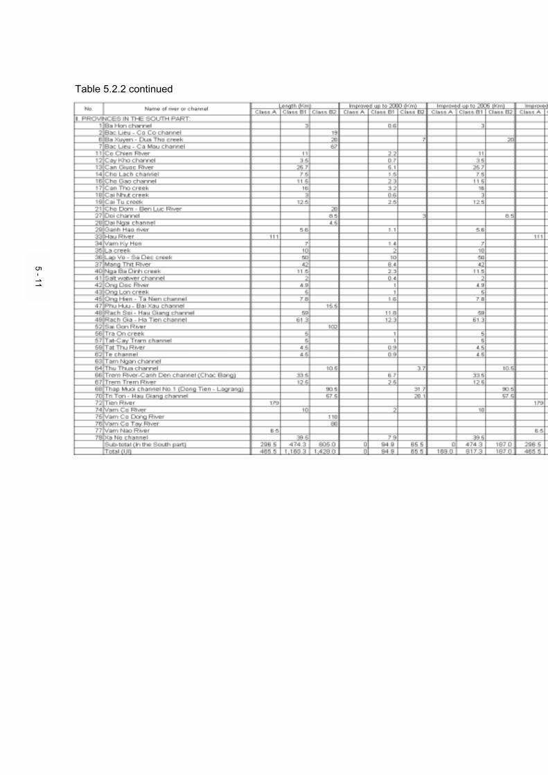
Table 5.2.2 continued
5 - 11

Vietnam National Transport Strategy Study (VITRANSS) Technical Report No. 7
Inland Waterway
5-12
4) Maintenance According to the “Draft Master Plan for Inland Waterway Transport of Vietnam toward the Year 2020”, VIWA forecast the managed length of waterway as shown in Table 5.2.3.
Table 5.2.3 Forecasted Data on Managed length of Waterways
At present, VIWA receives the maintenance fund of VND 10 million/km (US$ 714/km) on average from the state budget. It is considered short for maintenance of managed waterway even now. For instance, WB funded route in Mekong delta, the most modern waterway in near future, will require at least US$ 2000/km to maintain its original capacity. The Study Team suggests allocating fund for the maintenance cost as follows. a) Waterways under central management: ≥US$ 1,500/km b) Waterways under local management: ≥US$ 1,000/km
5) List of Potential Master Plan Projects
Project list proposed by the Study Team is shown in Table 5.2.4. Detail explanations of each proposed project are shown in the “Project Profile” sheets in the main report.
ActualData (1997)
ForecastedData (2010)
ForecastedData (2020)
Under central control (km) 6,231 7,240 7,500Under local control (km) 1,782 5,000 8,500Total managed length (km) 8,013 12,240 16,000

Vietnam National Transport Strategy Study (VITRANSS) Technical Report No. 7
Inland Waterway
5-13
No. Project Name Estimated Note SheduleCost
(million US$) -2005 2005-2010
2010-2020
W1 Hanoi/Khuyen Luong Port Improvement 11.0 X X- Hanoi/Khuyen Luong Port Improvement (II) 7.5 X
W2 Ninh Binh/Ninh Phuc Port Improvement 14.4 Ongoing X X- Ninh Binh/Ninh Phuc Port Improvement (II) 9.4 X
W3 Viet Tri Port Improvement 3.5 X X- Viet Tri Port Improvement (II) 8.1 X- Hoa Binh Port Improvement 4.0 X
W4 My Tho/Can Tho Port Improvement for IWT 6.1 Ongoing X X
-My Tho Port Improvement for IWT (II)(Can Tho Port improvement will be conducted as a sea portproject)
3.2 X
W5 Vinh Thai (Vinh Long) Port Improvement 4.3 X X- Vinh Thai (Vinh Long) Port Improvement (II) 2.6 X
W6 Ca Mau Port Improvement 2.9 X X- Ca Mau Port Improvement (II) 1.5 X
W7 Cao Lanh (Dong Thap) Port Improvement 6.4 X X- Cao Lanh (Dong Thap) Port Improvement (II) 6.1 X
W8 My Thoi (Long Xuyen) Port Improvement 6.2 X X- My Thoi (Long Xuyen) Port Improvement (II) 7.6 X
W9 Passenger Terminal Development 2.2 X- Passenger Terminal Development (II) 6.1 X
W10 Other Local Port Development 47.7 X X- Other Local Port Development (II) 42.0 X
W11 Quang Ninh-Hanoi/Pha Lai Waterway Improvement(Quang Ninh-Hai Phong-Hanoi, Quang Ninh-Pha Lai) 13.9 X X
W12Cua Day/Lach Giang-Ninh Binh/Nam Dinh-Hanoi WaterwayImprovement(Cua Day-Ninh Binh, Lach Giang-Hanoi, DNC Canal)
19.9 X X
W13 Quang Ninh-Nam Dinh/Ninh Binh Waterway Improvement 6.0 X X
W14 Hanoi-Viet Tri-Lao Cai Waterway Improvement(including Red River Embankment in Hanoi Area) 74.0 X X
- Hanoi-Viet Tri-Lao Cai Waterway Improvement (II) 33.2 X- Viet Tri-Tuyen Quang Waterway Improvement 1.8 X- Viet Tri-Hoa Binh Waterway Improvement 1.8 X- Pha Lai-Thai Nguyen Waterway Improvement 1.8 X- Pha Lai-Bac Giang Waterway Improvement 1.8 X
W15 HCMC-Can Tho Waterway Improvement 23.2 Ongoing XW16 Can Tho-Ca Mau Waterway Improvement (via Xa No) 17.6 Ongoing XW17 Cho Lach-Kien Luong Waterway Improvement 25.5 Ongoing XW18 HCMC-Kien Luong Waterway Improvement (via Dong Thap Muo 5.4 Ongoing XW19 Thi Vai-Nuoc Man Canal Development 3.2 X
- HCMC-Moc Hoa Waterway Improvement 1.1 X- HCMC-Ben Keo Waterway Improvement 4.3 X- HCMC-Ben Suc Waterway Improvement 1.1 X
W20 Waterway Improvement in Hoa Binh Lake Area 2.1 XW21 Cuu Long-Cambodia Waterway Improvement 20.5 X XW22 Island Service Improvement (Co To and Cat Ba Islands) 2.5 X
- Island Service Improvement (Other Islands) 4.6 XW23 IWT Safety Enhancement 52.7 X X
- IWT Safety Enhancement (II) 67.3 XW24 IWT Education 14.1 X X
- IWT Education (II) 14.1 XW25 IWT Fleet Development 191.9 X X
- IWT Fleet Development (II) 209.6 XTOTAL 1,017.8
(2001-2010) 577.2(2011-2020) 440.6
- Maintenance Cost 142.2 X X- Maintenance Cost (II) 180.0 X
GRAND TOTAL 1,340.0(2001-2010) 719.4(2011-2020) 620.6
Table 5.2.4 Project List

Vietnam National Transport Strategy Study (VITRANSS) Technical Report No. 7
Inland Waterway
5-14
5.3 Operation
1) ATN Improvement and Safety Enhancement At present, except some of major waterways, the facilities of ATN are insufficient, and safe navigation is not secured. Especially, nighttime navigation is impossible or very dangerous in many parts of waterways. In addition, the condition of many ATN is poor. Strategy on ATN improvement is as follows. a) Class A waterways: The target is to adapt the waterways of this class to
night navigation by installing day and night ATN by 2010. b) Class B1 waterways: The target is to adapt the waterways of this class
to night navigation by installing day and night ATN by 2010. c) Class B2 waterways: At the first stage, it is necessary for the waterways
of this class to install day ATN by 2010. And at the second stage, day and night ATN should be installed by 2020.
d) Class C waterways: As the waterways of this class are also important for local transportation, day (and night) ATN should be installed step by step at the major section of these waterways.
These improvements result in not only improving navigation safety, but also increasing operational time, efficiency and business profitability, so that transportation cost will be reduced.
To enhance navigation safety, it is necessary to handle law-breaking cases strictly by patrol, and to supply equipment and facilities for inspection including vehicles, high speed vessels, communications equipment, and so on.
2) Education
In Vietnam, there are three major institutes in inland shipping education and training, i.e. Inland Waterways School No. 1, No.2 and No. 3. Inland Waterways School No. 1 in Hai Duong is the oldest and largest school for the operational jobs on inland vessels. Inland Waterways School No. 2 in HCMC is somewhat smaller and trains for the same profession. Inland Waterways School No. 3 in Haiphong is substantially smaller, and its curricula are focused on a limited number of inland shipping aspects, mainly on navigation marks and dredging operations. (source: Netherlands report) Training demand has been continuously increasing, annual average regular students are estimated at more than 1,000 students by VIWA. Meanwhile, because of insufficient budget source for training activities, school/training equipment is short and in bad condition. Vessel operators and repairers are

Vietnam National Transport Strategy Study (VITRANSS) Technical Report No. 7
Inland Waterway
5-15
not well trained due to the short and poor school/training equipment. It is necessary to train operational skills by using more modern training equipment, i.e. radar, electronic navigation aids, radio communication equipment, PC-based simulators, and so on. In terms of these training facilities/equipment, sufficient budget source is necessary to strengthen IWT training system. In addition, special and extensive training program should be designed to increase the education level of the trainee.
3) IWT Fleet Development The total capacity of inland waterway fleet in Vietnam is estimated at about 1,290,000 DWT for cargo ship and 210,000 seat for passenger ship in 1997. Most of fleets are old, dating back to the 70’s and 60’s and even earlier, and renovated insufficiently. According to the ADB report, the fleet has shrunk continuously at a rate of between 3-5% due to its old age and an insufficient rate of renovation. The improvements of IWT including ports, waterways, ATN, etc. can only be accomplished in connection with the development of the fleet. For the fleet development, it is not only the inland waterway fleet, but also the coastal/sea-cum-river fleet that needs to be taken into consideration, because some waterways will be improved so as to be made accessible for coastal transport. The target of fleet development toward the year 2010 is estimated by VIWA, i.e. 1,929,087 DWT for cargo ship and 320,000 seat for passenger ship. Strategy on fleet development is as follows.
a) Sufficiently to repair existing fleet b) Newly to develop fleet and replace the old/existing fleet to keep up with
the expected growth in IWT (based on demand) c) To modernize fleet, such as higher powered tug which result in larger
barge capacity (DWT), vessels with shallow draft specially designed for sea-cum-river navigation, container transportation, etc.
5.4 Organization/Institution
This aspect is discussed in detail in separate Technical Report No.4 Transport Sector Institution.

APPENDICES

A-1
APPENDIX A CONTRIBUTION TO NATIONAL CONTAINER TRANSPORTATION
Nowadays, containerization in maritime transportation is a global trend, and it has prompted the modernization of international transportation. In Vietnam, container cargo volume loaded/unloaded at major seaports has increased in recent years, and the establishment of a container transportation network has become an urgent matter. Such a network in inland areas is not yet well developed with the exception of some routes, but it is sure to become vital to the economic development of these areas in future. From this point of view, inland waterway transport can possibly be used in container transport particularly in the delta areas, such as Mekong Delta, for the following reasons: 1) Hindrance in road development
• Construction cost of roads with many bridges over rivers and canals is high, therefore the development of a road network covering the whole inland area, including districts, would entail huge costs and a great deal of time.
• It is necessary to improve existing bridges to accommodate heavy trailers. At present, these vehicles ply only major routes or short-distance routes.
2) Lack of container trailers as a means of transport 3) Lack of railway (not yet developed in Mekong Delta) In using inland waterways to develop container transport, there are two alternative methods as follows (see Figure A.1): Alternative 1 Entering inland area after transshipping at major seaport in Vietnam Alternative 2 Entering inland area directly from foreign port Necessary conditions for development and characteristics of each alternative are shown in Table A.1. In order to use inland waterway for container transportation, there are some issues that should be further examined in detail as follows: 1) Investigation of new river container ship or sea-cum-river container ship involving the
examination and selection of the most suitable dimensions and carrying capacity of container, navigation speed stability, etc.
2) Examination and selection of the most suitable alternative through cost and benefit evaluation taking account of demand for river container transportation, characteristics of waterway route, etc.
3) Coordination with road development plan (schedule) and regional development conditions. Without access road from river port to regional development zone, river container transportation can not provide door-to-door service except for riverside customers.
4) Environmental conditions (shallow water depth and appearance of sandbars during dry season, fast water flow during rainy season, etc.)
These issues should be examined in detail under separate studies.

A-2
Figure A.1 Conceptual Image of River Container Transportation in Mekong Delta
Table A.1 Necessary Conditions for Development and
Characteristics of Each Alternative Case
Case Necessary Conditions for Development and Characteristics Alternative 1 - Introduction of container handling equipment at river port
- Improvement of existing barge, or development of river container ship with shallow draught specially designed for river navigation
- Suitable for long-distance transport because the rate of transshipment cost to total cost is small
- Suitable in the case that seaport has the capacity for ship-to-barge transshipment
Alternative 2 - Introduction of container handling equipment at river port - Development of sea-cum-river container ship with shallow draftt specially
designed for sea-cum-river navigation - Suitable for short-distance transport because transshipment cost at
seaport which is proportionally large to total cost is reduced - Suitable for seaport without capacity for ship-to-barge transshipment
Sea & River route
3 : Sea-cum-river container ship with shallow draft specially designed
3
Foreign port (Hong Kong,
Singapore, etc)
River port in Mekong Delta (Can Tho, etc)
(Alternative 2)
River route Sea route
1 2
Foreign port (Hong Kong,
Singapore, etc)
Major seaport in south Vietnam (Saigon, Vung
Tau (future),etc)
River port in Mekong Delta (Can Tho, etc)
1 : Normal container ship 2 : Barge, or River container ship with shallow draft specially designed
(Alternative 1)

B-1
APPENDIX B REQUIRED SURVEYS AND STUDIES
Surveys are essential in the development of inland waterway transport. To date, however, there has been a lack of basic hydrographic surveys except on some major waterways. Further surveys are strongly required to understand the present condition of waterways and to confirm the methods for improving them. For example, siltation is probably the main obstacle to the development of inland waterway transport in Vietnam. In order to devise countermeasures for reducing siltation and establish an effective dredging method, it is important at least to understand its mechanism at the heavy and irregular sedimentation sites on the basis of a long-term engineering survey. Before deciding the master plan on inland waterway transport system, further detailed surveys and studies should be properly conducted. Representative surveys and studies required are listed in Table B.1.
Table B.1
Representative Surveys and Studies Required
Survey/ Study Objectives Basic survey on hydrographic characteristics and measurement of waterways (based on up-to-date soundings, etc.)
-To measure dimensions of waterways and to identify the bottleneck in the waterway route, especially in dry season
-To evaluate the volume of dredging required to improve waterway
-To provide navigational charts periodically and to improve navigation safety
Study on countermeasures for reducing siltation and establishing an effective dredging method, especially in river estuary (based on the field survey, from the economic and technological viewpoints.)
-To determine quantitatively the principal factors of siltation
-To work out possible improvement measures for reducing siltation (contributing to reduction of dredging backlog)
-To work out effective dredging method (setting up optimum water depth for planning of waterway development, etc.)
Study on the development of an advanced water transport system, such as vessels with shallow draft specially designed for sea-cum-river navigation, container transportation, etc. (from the economic and technological viewpoints, considering future improvement plan on waterways.)
-To increase the capacity of waterway transportation
-To reduce the initial and maintenance dredging volume at river estuary
-To contribute to national container transportation network
Comprehensive master plan on river ports -To identify the function of each river port -To estimate and set up the capacity of each port -To formulate a comprehensive master plan on river ports

C-1
APPENDIX C POLICY FOR IMPROVING PORT STATISTICS SYSTEM
1. General
One of the most significant assignments of government is to compile and publish reliable statistics such as those on natural and socio-economic conditions and the status of national assets and activities. Without a firm base of statistics, accountable policies and plans of the country cannot be formed. In formulating the port development strategy, such as the long-term development and improvement plan, port statistics are very important in projecting future demand of cargo and passenger, examining improvements on port facilities and equipment, etc. With the exception of major ports, statistical data at most river ports is not well prepared.
2. Basic Policy in Improving Port Statistics System
The basic policy to improve the port statistics system is as follows: 1) Port statistics should have a uniform format so that they can be easily
accessed and understood by the entire nation and concerned parties. 2) Port statistics should comprehensively involve all ports, not just those
managed at central and local levels but special ports as well. 3) Port statistics should at least clarify the trend of cargo volume of each kind of
commodity, its origin/destination and cargo type, the number of calling vessels, number of passengers, and port characteristics such as water depth in front of wharf, area of stock yard and warehouse, etc.
4) If possible, port statistics should be integrated with the statistics system of land transportation, which is closely related to port activities, and be compatible with the international statistics system.
For a detailed improvement of the statistics system, a separate study should be conducted.

D-1
APPENDIX D COST ESTIMATION OF PROPOSED PROJECTS
1. Calculation Method of Port Capacity Requirement
Parameter of Port Design Data (A) Design Cargo Throughput: Forecasted cargo volume by each port (B) Design Vessel: 4*200t barge convoy
Barge (L*W)=36m*7m Barge convoy (L*W)=72m*14m
(C) Design Berth Length: 72m (D) Number of Crane per Berth: 1 (E) Crane Capacity: 25t/hr (F) Operating Hour: 8hr/shift (G) Number of Shift: 2shift/day (Target in 2010) (H) Working Day: 330days/year
(including 10% down time and preventive maintenance)
(I) Dwell-times of Cargo Storage 2.5days (J) Effectiveness of Warehouse Space Use
0.7
(K) Peak-factor 1.2 (L) Storage Capacity 2.0t/m2
(1) Maximum Throughput Capacity per Berth = (D)*(E)*(F)*(G)*(H) = 132,000t/year/berth (2) Requirement of Berth Number = (A)/(1) (3) Requirement of Berth Length = (C)*(2) (4) Requirement of Crane Number = (D)*(2) (5) Requirement of Forklift Number = (4) (A)*(I)*(K) (6) Requirement of Storage Area = (J)*(L)*(H)
2. Cost Estimation Method of Port Improvement Calculation Method of quantity of each item A. Civil Works
(1) Berth Length = Quantity based on the calculation of port capacity requirement (2) Pavement = (1)*20m width (3) Dredging = (1)*50m width*2m depth

D-2
(4) Refilling Port Area = (1)*50m width*4m height (5) Access Road = Required quantity
B. Facilities & Equipment
(1) Warehouse = Quantity based on the calculation of port capacity requirement (2) Mobil Crane = Quantity based on the calculation of port capacity requirement (3) Forklift = Quantity based on the calculation of port capacity requirement