4. ha-11 - maryland historical trust ha-11 maryland historical trust magi # 1300115214 inventory...
TRANSCRIPT

H A-11
MHT EASEMENTS ON TIIE WILSON'S MIIL CCK>LEX
1. HA-392 Wilson's Mill Tenant House
2. HA-25 Wilson's Mill Miller's House
3. HA-10 Wilson's Mill House (Main House)
4. HA-11 Wilson Mill

HA-11
Wilson'E= Mill 702 Darlington Road Darlington vicinity Private
c. 1800
Wilson's Mill is the most important b·.iilding in the Wilson's Mill complex, one of +-he oldest ,qnd most complete mill ;:::;roups on Deer Creek. Mills such as this were important factors in the settlement of the area and the growth of in~ustry in the county. Possibly built as early as 1760, the stone structure has the dates 1810, 1825, and 1845 carved into its walls and rafters.
' HA-11 MARYLAND HISTORICAL TRUST MAGI # 1300115214
INVENTORY FORM FOR STATE HISTORIC SITES SURVEY
UNAME HISTORIC
1:Jilson' s Mill AND/OR COMMON
flLOCATION STREET & NUMBER
702 Darlington Road CITY. TOWN
Darl jng+an STATE
Maryland
L VICINITY OF
DcLASSIFICA TION
CATEGORY
_DISTRICT
~BUILDINGISI
_STRUCTURE
_SITE
_OBJECT
OWNERSHIP STATUS
_PuBuc XoccuP1rn JCPRIVATE _UNOCCUPIED
_BOTH _WORK I~ PROGRESS
PUBLIC ACQUISITION ACCESSIBLE
_IN PROCESS *YES RESTRICTED
_BEiNG CONSIDERED
x Not applicable _YES UNRESTRICTED
_NO
·dowNER OF PROPERTY NAME Windon Fifth Real Estate Ltd. Partnership
c/o Robert Olson __ _ STREET & NUMBER
.Suite 253, 111 Presidential Elvd.
CITY TOWN Bala Cynwyd,
_ VICINITY OF
llLOCATION OF LEGAL DESCRIPTION COURTHOUSE
REG:srnv OF DEEDS.ETC Harford County Co,.irthouse STREET & NUMBER
4o So. Main St. CITY TOWN
Bel Air
II REPRESENTATION IN EXISTING SCRVEYS TITLE
CONGRESSIONAL DISTRICT
1st -~OUNJY Har1·ord
PRESENT USE
_AGRICULTURE _MUSEUM
_COMMERCIAL _PARK
_EDUCATIONAL _PRIVATE RESIDENCE
_ENTERTAINMENT _RELIGIOUS
_GOVERNMENT _SCIENTiFiC
_INDUSTRiAL
__ MlliTARY
_TRANSPORTATION
X..oTHER storage
Telephone #: (215) 667-3505
STATE ,
PA
Liber #: 1143 Folio f:: 73
STATE
MD
zip cod.e 19004
Maryland Historical Trust Historic Sites Inventory DATE
c. 1970 DEPOSITORY FOR
SURVEY RECORDS
CITY. TOWN
Mnryland Historical Trust
L\.nnapolis
_FEDERAL .:{.STATE _COUNTY _LOCAL
STATE
'!-[)

II DESCRIPTION
_EXCELLENT
:f-GOOD
_FAIR
CONDITION
_DETERIORATED
_RUINS
_ UNEXPOSED
CHECK ONE
_UNALTERED
;{--ALTERED
CHECK ONE
*ORIGINAL SITE
_MOVED DATE ___ _
DESCRIBE THE PRESENT ANO ORIGINAL (IF KNOWN) PHYSICAL APPEARANCE
\/ilson 1 s Mill is a two-and-a-half story stone industrial building dating from the early 19th century and located on the north bank of Deer Creek just west of ~he Darlington Road (MD 161) bridge in Harford County, Maryland. The millrace runs from the west to the mill, turning to parallel the west wall of the building and ru:rtning back to the Creek.
The mill was built of uncoursed rubble stone with large quoins a~d a slate gable roof. The unner ~ortion of the gables is frame with horizontal siding. On the west gable is a clock face; the clock (installation date unknown) is not presently operating, but is run by a weight and pulley system inside the mill. A board and batten frame shed was added to the northwest side of the stone block at an unknown date. The stone walls are stabilized by iron tie rods finished on the exterior in rosettes and ogee curves. ',vindows and doors are functionally placed in an irregular pattern. Most are six-over-six sash. The main entrance in the north elevation is a Dutch door with tongue and groove planks.
The interior of the mill retains itG hand-hewn structural beams. The shed contains the miller's office with the original desk and chair. The gristmill machinery was removed and stored in the third floor loft in 1931. A water-powered electrical generator was installed and remains in place, but is no longer used. The current owner plans to restore the generator and return it to operation.
The mill darn and the head of the mill race are located about one-quarter mile upstream. The darn was rebuilt in 1932 by :!"rancis J. Stokes, then owner of the mill property.
The ~.aryland ~istorical Trust obtained a perpetual easement in 1976 on ~he exterior of all buildings, the interior of the mill, and its machinery.
CONTINUE ON SEPARATE SHEET IF NECESSARY

B SIGNIFICANCE
PERIOD
~REHISTORIC
400-1499
-'500-1599
_1600-1699
x_ 1700-1 799
_1800-1899
_ 1900-
AREAS OF SIGNIFICANCE -- CHECK AND JUSTIFY BELOW
_J,.RCHECJLCJGY-PREHISTORIC _COMMUNITY PLANNING _LANDSCAPE ARCHITECTURE
_J,.RCHEOLOGY-HISTORIC _CONSERVATION _LAW
_j,.GRICULTURE _ECONOMICS _LITERATURE
____ARCHITECTURE _EDUCATION __ MILITARY
_J,.fH _ENGINEERING _MUSIC
_COMMERCE _EXPLORATIQN!SETTLioMENT _PHILOSOPHY
_COMMUNICATIONS -X1NDUSTRY _POLITICS/GOVERNMENT
_INVENTION
SPECIFIC DATES c. 1800
BUILDEI~/ ARCHITECT
STATEMENT OF SIGNIFICANCE
_RELIGION
_SCIENCE
_SCULPTURE
_SCJCJAUHUMANITARIAN
_Tr<EATER
_TRANSPORT A T!ON
--XOTHER !SPECIFY!
local history
'viilson' s Mill is the most important building in the dilson' s Mill complex, one of the oldest and most complete mill groups on Deer Creek. Mills such as this were important factors in the siettlement of the area and the growth of industry in the county.
HISTORY AND SUPPORT
Wilson's !Iill stands on the tract 11Parker's Chance" acquired in 1743 by Nathan Rigbie; his will mentions a m:~ll1and dam in 1783. One source states the present mill was built in 17b0. The mill does not appear on the 1795 map of Harford County. It passed -::;o Joseph Brinton in 1802, to Reuben Stump in 1821, to Rachel Price in 1856, and into the Hilson family through her second husband, William Wilson, and thence to their son, David Wilson. in 1866. Wilson's Mill appears near the D.E. Wilson house on the 1858 Jennings and Herrick map.
The 1880 census listed David E. Wilson's custom mill worth $6000 with five employees, three run of stones, and 500 bu/diem maximum. A 10-foot fall on Deer Creek drove a 25 hp, 3-foot turbine at 120 rpm. Its output was 250 bbl flour, 26 tons meal, 9.7 tons foed, and 1 ton hominy ($3000). The sawmill, worth $1000, h8-d two employees and one each circular and Muley saws. '!'he same fall on Deer Creek drove a 30 hp, 3-foot turbine at 200 rpm to cut 200,000 ft. ($4000). The mill is also :cisted under Glenville in the 1887 state directory.
D. Gilpin Wilson operated the mill from 1903 to 1931. Mr. and Mrs. Francis J. Stokes acquired the mill in =~931 and used it to house an electrical generator for the estate. In sp:~ te of its claims to age, the date 1810 is-chiseled into the wall. A stone in the exterior north elevation bears the date 1845 and an interior rafter has an 1825 date.
1 Harford County Directory, 1953, p. 31~).
For further information on the ':/ilson' s Nill complex, see Wilson's Mill House (HA-10), · Iilson' s l·~ill Miller's House (aA-25), and Wilson's Mill Tenant House (HA-392).
CONTINUE ON SEPARATE SHEET IF NECESSARY

IJMAJOR BIBLIOGRAPHICAL REFERENCES Harford County Directory, 1953 Mason, Samuel, Jr. Historical Sketches McGrain, John. Molinogra:Jhy of Harford C:ounty. of Harfo~d ~aunty, Mar~land, 1940. Preston, 'r. ·i. !!istory of Harford County. Forwood, W1l~1 1am S~ump. Ho~s on ·'right, c. M. Our Harford Heritage. Deer Creek , Aeg1s-Intell1gen1 Maps: Jennings---aild Herrick, 1858 Dec. 1879-February 1880.
Martenet, 1878 CONTlNUE ON SEJ;>AMTE SHEET IF NECESSARY
II!JGEOGRAPHICAL DATA ACREAGE OF NOMINATED PROPERTY _______ _
VERBAL BOUNDARY DESCRIPTION
LIST ALL STATES AND COUNTIES FOR PROPERTIES OVERLAPPING STATE OR COUNTY BOUNDARIES
STATE COUNTY
---------------------------------------~~~ STATE COUNTY
mFORM PREPARED BY r..;AME, TiTLE
Janet L. Davis, Historic :;i tes Surveyor ~--------------------------ORGA'<iZATJON
Harford County Dept. of Planning and Zoning DA"7"E
September 1982 STREET & NUMBER •ELEPt<ONE
45 So. Main St. (301) 838-6000, ext. 207 C:TY OR TOWN sr•n
3el Air MD 21014
The Maryland Historic Sites Inventory was officially created by an Act of the Maryland Legislature, t~ be f~und in the P. .... '1Y'1::Jtated Code of Maryland, Article 41, Section 121 KA, 1974 Supplement.
The Survey and Inventory are being prepared =or information and record purposes only and do not constit~te any infringement of individual property rights.
RETURN TO: Maryland Historical Trust The Shaw House, 21 State Circle Annapolis, Maryland 21401 (301) 267-1438
PS· I IOI

HA-11 Wilson 1 s Mill
CONTINUATION SHEET
8. Significance (continued)
Samuel Mason, in Historical Sketches of Harford County, Maryland, gives the carved inscriptions on Wilson 1 s Mill as: "S.B. Silver, 1817; E.R., 1822; and C.R. Smith, 1837". C.R. Smith was the miller in 1837 under the ownership of Reuben Stump.
~~illiam Stump Forwood, in his "Homes on Deer Creek" series in the AegisIntelligencer in 1879-80, referred to ~~ilson 1 s Mill as "anciently called Alfred Mills". The source of this name is unknown.
The main route between Darlington, Glenville, and Harmony Church ran along the present access road between the Mill and the Mill House on the hill. According to Mason 1 s book, the original covered bridge crossing the Deer Creek stood opposite the Miller's House and was washed away in a freshet in 1865. The second covered bridge was built at another location east of the present bridge. (See HA-393 and 394.)

rorm 10-445 l. 5TATE '.lary I and (s
62) couNTY Harford
HIST ..: AMERICAN BUILD! NGS SURVEY
INVEMTORY HA -JI
LL 0 1-uJ LJ
z 0 0 u..: 0 0 <(
TO\\'N Dur I i ngton v1c1N1TY STREETNO.f~t. 161
ORIGINALOWNERj.)ossibly, Col. l\igbie ORIGINAL usE mi I I PRESENT OWNER .irs. Francis Stokes PRESENT USE 9enerati ng plant WALL CONSTRUCTION stone NO. OF STORIES tl\'O
2. NAME , 1 I son 's ,·.1 i I I or
:\igbie's 'lill DA TE OR PERIOD revo I ut i onary STYLE r:i1ll ARCHITECT BUILDER
3. FOR LIBRARY OF CONGRESS USE
4. NOTABLE FEATURES, HISTORICAL SIGNIFICANCE AND DESCRIPTION OPEN TO PUBLIC no
The mi 11 1s a typical grist mi 11 structure, thr«.~ bays
wide .:md two bays deeµ 1vith the entrcince 1n the gable. It
is bui It of stone on the banks of Deer Creek. It retains
some original structural members within and sone window
framing. The doors are batten "Dutch" doors. i)resentl y,
there is a turbine engine 1"hich 1s used to ~1enerate electricity
c lo I CL
.::i z -1:
z 0 1-..-c ::;_
0 u... z _J <(
1-z :....J ~ :...;_: _J
CL CL ::J V)
for the farm. It was bu i It on property cal led ''Parker's
Chance'' and µossibl y by Natlia:n l\igbie who owned the i\igbie
f--:ouse, a few miles north of th is point. There are records
of Col. f(igbie having supplied the Continental Army with
supplied from his mi II.
5. PHYSICAL CONDITION OF ~TRUCTURE Endangered
~ 6. LOCATION MAP (Plan Optional)
3. PUBLISHED SOURCES (Author, Title, Pages}
INTERVIEWS, RECORDS, PHOTOS, ETC.
.<.<.<A Interior g,l() d Exteriorqoo.,
7. PHOTOGRAPH 9. NAME, ADDRESS AND TITLE OF RECORDER
f,Jichael Bourne
l·lary I und Hi stor i ca I Trust
DA TE OF RECORD 1-iav 9. 1968 . '
V"I
z 0
V"I
z
w w
: .. ( I/;) - I/ Form 10-300 UNITED STATES DEPARTME"T OF THE llHERIOR
STATE:
t (Dec. 1968) NATIONAL PARK SERVICE . '9 ·~ COUNTY:
NAT I 0 NA L R E GI ST ER 0 F HI ST 0 RIC P LAC ES ~<'.) INVENTORY - NOMINATION f'ORM s~<- FOR NPS USE ONLY
f') ENTRY NUMBER I DATE
(Type all entries - complete applicable sections) I f i. NAME
COMMON: ill ;U!/ UZ .Sek ~r ANDIOR HISTORIC: rf;'o/ bur, !Ld /:! b rL,_CJZ- Vi
A~r ../
OU- ~ s
12. LOCATION s'TREET ANC' NUMBER:
11~ ( w.A'"c- 9 { fl!riL {~L tr.-A -rt 1) .fl id>r .u<irL 7
hl-;. ,1 /;a~c ~ CITY OR TOWN: I
j)Cl L (~~._ /, 1 - Seu.IL c,f j /?A-( STATE
//( cet-~/ au<!-[ CODE I COUNTY
/-/ a 1'L kz L I CODE
I I I 13. CLASSIFICATION ,J
CATEGORY I I ACC ESSI BL E OWNFRSHIP STATUS
! TO THE PUBLIC (Check One) !
District 0 Bui I ding ci/ Public - Public Acquisition: Occupied ~·Yes: I/ .:-_j '---
~I Restric'.ed ~ Site 0 Structure - Private 7 1 n Process 0 Unoccupied ~ -- Both ~ Being Considered L Preservation work : Unrestricted .__:
Object ~ in progress :::JI No: ::J
PRESENT USE (Check One or .'\.lore as Appropriate)
Agricultural - Government - Park ::J Transportation - Comments c ~ c__C ' '
Commercial D Industrial ::::J Private R•esidence 0 Other we~ify) ~ Educational ~ Military ;i Rel;gious ::::J ~j'*WAfZ ~/J{?Ju.c
~
Entertainment c Museum ::J Scientific ~ p ~ ;1 i '-a::l~ rvL __. -{f,...,L_ -~ ·
!4. OWNER OF PROPERTY
!CITY OR TOWN: ,/,I . ~ =Pu.It ad Y-t L~
""5-.-"-L-O_C_A_T_l_O_N_O_F_L_E_G_A_L_DESCR IP TION ;
STATE· CODE
--------------------------------4 COURTHOU~~~TRY 7
CITY ORT CODE t
APPROXIMATE
6. REPRESENTATION IN EXISTING SURVEYS /TITLE OF SURVEY:
1DATE OF SURVEY: F edera I !DEPOSITORY FOR SURVEY RECORDS:
State =::::J County ::::J Local
I
lsTREET AND NUMBER:
CITY OR TOWN: STATE: CODE
I
n 0 c z -; -<
rn z -; Jl -< z c ;:: Gl rn Jl
0 ,, -; rn
-n 0 ;u
z "U V>
c V> m 0 z r -<

., . ''· -f7. DESCRIPTION ---
(Check One) CONDITION
Excellent ./ God D F · D t-----+_:_::._::..:..:...::.~..'::::[!"J::_____::.:_:"'o~ air Deterior-oted D Ruins
INTEGRITY . jCheck One) I D Unexposec D (Check One)
Altered ~ Unaltered D Moved D Original Site B DESCRIBE THE PRESENT AND ORIGINAL (if known) PHYSICAL APPEARANCE
In; ~
f'' (L7
-l.U (~ ~L c_,C h
1{.£~ 7/_ S'(·u d · h~Jl,d U JD?/ j
1 b a. -ti~ Sz~aJUA ~
I
,.,-, ;Ji="--L~' ~y; ~(/~• :::::.:.£:'.-c U/~ , V (l:f2c 12~7/
u1de rf 1 (£.;£ //or:7 c:_7 o '/L,L ,,/ :,{. ~/:,,,/ !Jte<' L ';,J/ /'<.n~ '"" r , c£ Ilic""-[/ /l, fk / . ."-'
<' /,/f;..,'e rW t ,tf,,'"- /, SU }f ~ f cu <L
,'?/!_ VU{_ . j~4vv'' ·r_u,j lL)t~~/5- r.
fl 11;.;J_ ~o cL-/ ¢
(.,[ L;1 i..<_,Zf-5
l~-l;er ~ /
/u1 i~Jr I-:_
/1:.V~ f~ If 3 2 u} s&t<'-..z,-
' t)k_ 1).u-i (~L ~
m m
z
~
;;:c
c: n -i
0
z

V')
z
0
I-
u J
ct::
I-V')
z
w w V')
· Sl(;~lflCANCf
PERIOD (Check One or More as Appropriate)
Pre-Columbian D 16th Century D 18th Century
15th Century D 17th Century D 19th Century D
SPECIFIC DATEISI (If Applicable and Known)
AREAS OF SIGNIFICANCE (Check One or More as Appropr;·ate)
Aboriginal Education
Prehistoric D Engineering
Historic D Industry
Agri cu I tu re [J Invention
Art Ci Landscape
Commerce D Architecture
Communications D Literature
Conservation ~
Military
Music
STATEMENT O SIG
""
I atP.;;?J-<'--- -
fcl( ~' 1-<. c~l J
([ /J.Lk/d t; ds ;;/;_la j cl}iu :V
t~?hi/7 11~ 0, t-£- W1 j lc.-L r
4 ii tLCtr r~~a/ (,..,~~u ,,1-;
Political 0 Religion/Phi-
losophy 0 Science ~ Seu I pture D
0 Social/Human-
0 itarian O 0 Theoter O 0 Transportation D
•'
20th Century !l
Urban P Ianni ng 0 Other (Specify) ;:]
4'27.i( iJ
I

9, MAJOR BfBLIOGRAPHICAL REFERENCES
/ ~ttye74 1 ~U<J, 4~J-;~ ;z_,ft/,,.; c/
0
/-bi-}~1 _ _h~~-i--~-----
"- !l1 . prfa -6 2 - -r: 3
~ru;,lr: { /L,/~/ !/u1j1_L -!l u 1a.1-e- }· I 7 7
df,, d fc"'__.ICV.. fiu j)?~~~f_ f · -z f .,--
-- -- ----- _J_ I
10. GEOGRAPHICAL DAT A LATITUDE AND LONGITUDE COORDINATES D
LATITUDE AND LONGITUDE COORDINATES
DEFINING A RECTANGLE LOCATING THE PROPERTY DEFINING THE CENTER POINT OF A PROPERTY
R OF LESS THAN <?N~ ACRE
CORNER LATITUDE LONGITUDE LATITUDE LONGITUDE
Degrees Minutes Seconds Degrees Minutes Seconds Degrees Minutes Seconds Degrees Minutes Seconds
NW 0 . 0 . 0 . 0 . I NE 0 . 0 . i SE 0 . 0 .
SW " . 0 . LIST ALL ST AT ES AND COUNTIES FOR PROPERTIES OVERLAPPING STATE OR COUNTY BOUNDARIES
STATE: CODE COUNTY CODE
STATE: CODE COUNTY: CODE
STATE: CODE COUNTY: CODE
STATE: CODE COUNTY: CODE
11. FORM PREPARED SY NAME AND TITLE:
\L~ s. --- ' (:;: u,~-
ORGANIZATl-?N ~ t/-,.;ldu-; _.,..- !DATE/\ I {<J
/// O£ui . """uL l'l.uf'f fUc:/ ·; STREET AND NUMB'1R:
?u S/ah· [utJ-e_ CITY OR TOWN:
Al{v<-a)tJ /;,. STATE
;JI a''Lvj lu~L-CODE
12. ST ATE LIAISON OFFICER CER'M FttAT ION NATIONA! REGISTER VERfFICATION
As the designated State Liaison Officer for the Na-
tional Historic Preservation Act of 1966 (Public Law I hereby certify that this property is included in the
89-665). I hereby nominate this property for inclusion National Register.
in the National Register and certify that it has been
evaluated according to the criteria and procedures set
forth by the National Park Service. The recommended Chief, Office of Archeology and Historic Preservation
level of significance of this nomination is:
National :::::J State ---, Local r::J ~
Date
Name ATTEST:
Title
Keeper of The National Register
Date Date
m
m
z
0
z

J/:J-11
u_,/_k ftvt.f_-CL/i/f.-- {µA_ ~( f 13 / " .- · r '
{cu"--fu;_,_(_ a~ cµ_i&,9 sk1 )

=
\ \
i \ \
·~
\ \ / I ' I I
\ I ).f
)
: . .,r--.
/ I
,,..
HA-11 ) ru;;n' s Mill Stokes-W lson Mill) ~ 702 Darlington Road (MD 161) .\
(U rford County Dept. of·Planning maP: om aerial hotos take' March, 199Q
I _.j
~----.---.- x
x
HA-11
\
r--- ... ~ .. ·_,;·

• //arn ,
· ·''// ,• • /f'l';IHN/l/r/hn/N
~ .. ;'h'f ·l/f
• i: . '/,'/,, 'll ~
i S /k7°1/f; .11.,·
, I/ l,ur/t '
' .
. .. •'.
'" •· -
, .. 1. . -
·:i .... ,. . ,,.. I
II , ' /
• ././1Nn.••
./ lluph n' •
• '/'/lnr/n.1N
I Il .\RLINOTC>X
• • • ,/ /'o "-.
e '.l/un.:', • . r .,;;Jl'//Pj.1lrU1<1 ' • // -
~ 1· "·,.,,,,,,,,11 -~ 1r·
• J5 r•· I'· <'111 /, -:p
• . . --
lh1 /JI J>nr(' • I ./' //11//,11Ya)
• ./.11/ Ir ,,;z. \
I Old.Jhll •
lf/11.ntll
~ 'i ii
./,\im'll"'r> I
'.l;.1t. ,,. " t'A •
o./t'lu ., /, ,rr{
/ll' ' /l1'1.l>rrw
t .,
• • l f1,/d/,./v;1 • ./I'~"'"'
// ;111/1 ;,,, 1./..f. lh,·nfohlo I{ '7'.lf/t'IU -,. /'
• ( • ., 1· If Ill•
• 'f ;r /f'I// , . •
• I'
•
I Jf'//r II •IN•· •1 •
1r1·,,,,,,,,//, /.%'/Ao/k..-:r •
./ //tty/,..-r I
• ///n/y1/l/rL/L
• Jrlr : l/11'1//..-1.
• ,_ • !
•I
~ 0
,, . i . 1. ... I
. ,,, 1 •
,,, .. .,, J..,,.
·-• " J;. ,,1,, . "'·''"" f' """,..,,,,. . .,, . . '· ., "''''·•114. I U /t. •
\
I "'I#' ~ .
I /
\,r: ~·· ..
\

rs · S3 3 ~.. •I )9!,J; Sl\\1 O!t i • JJ. 11 I
£Sn1
I"""'< 'I\ s
: THE \NTl RlOR : L sui<VEY
I
. ,
.. I
'f\ ' ,,,~ 11 , u~·\·tt..i'· ( ...
I
4
•91 r
/ (
......
/1
Mounta\11 Hill
. . l . ~
-.~ l
) I
(•
. ) ) l '
"'*
'\ J
I ·. ~ ~-- Sl •
... . <' ~~ ~
I
9
0 ' . '#
( Ii
. ~
( ~\
""I . . I
), 1 .:i :l . ·~
~ '
J I
- -:::' . . ~ .. (
' /1 ·"'
... { . o· · ·~ .... -'.,. ,~ . ..,,,
\ -\ '• I (
/' ~ I J '\
-
I )
; I '.l ' . ,. ~·· ..... ,.
~-·\ " :::-)
Li
!/
I '-
?. ,
'\ -::-... ~ ~ .. ;..
~ :-... I.:
l
' ... -
( \ l,'
\. 'I ........
I
I
... •
.. . . • II
•• 11 . h ,. I M
11 • • 'I M I }( " I ~
( " 11,. ..
-~·· ~·,""""7,..t
""
... . ' ...
~
-
l ,.
' ' .-
.....
' .
., "( t)l\/n-.,.,, I •
~~!.. ,~,"·r.a Ct \ -
....
\
\ •
.....
V\ • I "'
0
'i ~ ' . ;:
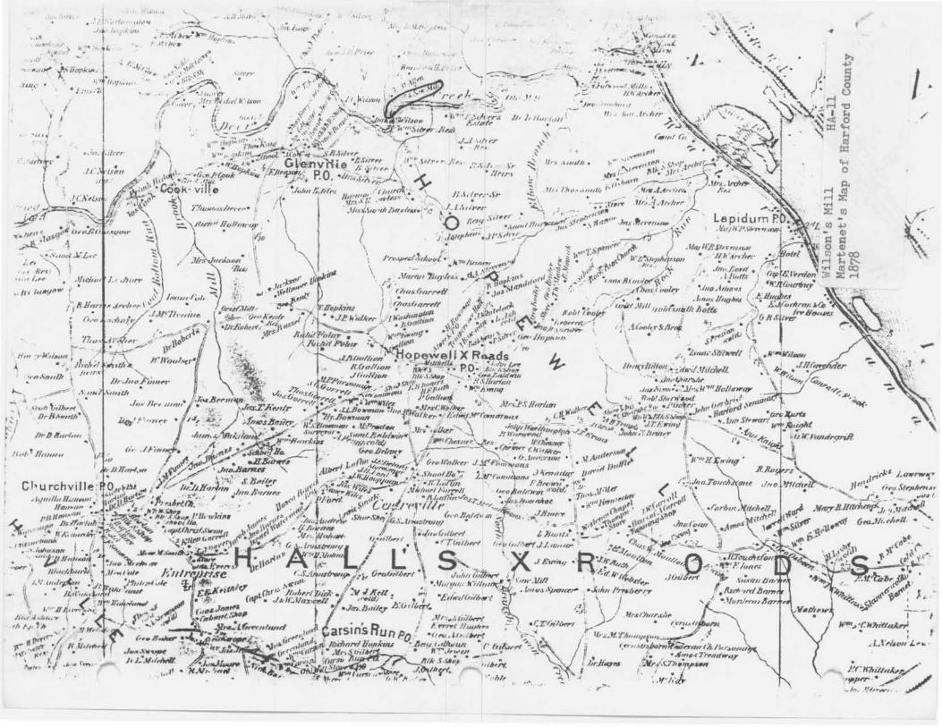
'·~~ Wilson's Mill HA-11 Aberdeen Quadrangle USGS 7.5 minute series Scale: 1:24o00 Harford County
(itt••••1 •"t"•··,. -1 II .
,.
.. .
11 • • •
.,. ·/·· -
., ,- . ......
... / ··. . ..
..
I•
.. p_


H./J I J •


Wilson's Mill HA-11 Harford County, Maryland Photo : Janet Davis September 1982 Vi ew from north 1/2


Wilson's Mill HA-11 Harford County, Maryland Photo: Janet Davis September 1982 Sluice gate, view from south 2/2


f/1+-/I