4 people 100km 30 hours - oxfamapps.org
TRANSCRIPT
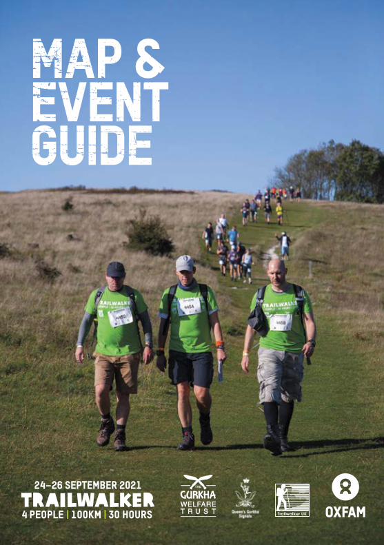
trailwalker4 people | 100km | 30 hours
24–26 september 2021

Welcome to Trailwalker!You are about to take on the most incredible adventure. Taking on the South Downs Way with your three teammates and your wonderful Support Crew. Getting stuck into your training. Figuring out what kit works for you. Asking your friends, family and colleagues to sponsor you for this epic team endurance challenge. All for Oxfam and The Gurkha Welfare Trust, and to support those in poverty around the world.
This guide is part of your compulsory kit. You will need to bring this with you on Trailwalker weekend. Don’t lose it.
trailwalker4 people | 100km | 30 hours
24–26 september 2021
Contents3 Registration and start times
4 Food
5 Transport
6 Accommodation
7 Environmental impact
8 Compulsory kit list and advice
10 Fundraising: Oxfam and The Gurkha Welfare Trust
11 Training and nutrition
12 Route – overall map and facilities
14 Route – rules, profile and navigation
15 Route – official map and directions
28 Emergency info
We would like to thank the following for their continued support in the event: Queen's Gurkha Signals, The Gurkha Welfare Trust,
Queen Elizabeth Country Park and Brighton Racecourse.

3
Registration Registration takes place at the start point, Queen Elizabeth Country Park, Petersfield, PO8 0QE. If you have a 6, 6:30, 7 or 8am start time you MUST register on Friday evening. Please note, you are expected to be at the start area 15 minutes before your start time. Teams will be
Event Weekend
Registration is limited to the following times:
The registration procedure will be as follows:Step Who What Where
1 Team Leader Collect Registration Pack upon arrival Registration desk 1
2 All Team MembersCheck your personal details sheet in the pack, and update as needed - Sign kit disclamer - Sign to agree Trailwalker terms and conditions
3 All Team Members Return completed and signed registration forms Registration desk 2
Start Time* Registration Comments
06:00 Fri 16:00 - 22:00 Friday registration mandatory
06:30 Fri 16:00 - 22:00 Friday registration mandatory
07:00 Fri 16:00 - 22:00 Friday registration mandatory
08:00 Fri 16:00 - 22:00 Friday registration mandatory
09:00 Fri 16:00 - 22:00/Sat 05:30 - 08:00 Friday registration recommended
*Start times are subject to change.
GPs For the first time, This year Trailwalker is using GPS trackers to monitor each team's progress along the route.
The trackers will make Trailwalker safer by helping us reach you quicker if an accident occurs. They will also allow your support crew and friends back home follow your live location on the route.
Each team will be issued with one tracking device. It's really important you don't lose this! If someone drops out of the event, please make sure the tracker stays with the remaining participants. If a whole team drops out, please make sure you return the tracker to a checkpoint manager.
In the event someone is injured in a remote location and you don't have phone signal, please make sure you leave the tracker with the casualty when you go to find signal or help. For more information about what to do in an emergency, see the back page of this guide.
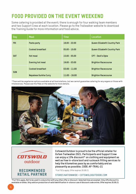
Day Meal Time Location
FRI Pasta party 18:00 - 22:00 Queen Elizabeth Country Park
SAT
Cooked breakfast 05:00 - 10:00 Queen Elizabeth Country Park
Hot meal 15:00 - 05:00 CP7 - Devil's Dyke
Evening hot meal 19:00 - 03:00 Brighton Racecourse
SUNCooked breakfast 03:00 - 11:00 Brighton Racecourse
Nepalese Gurkha Curry 11:00 - 16:00 Brighton Racecourse
4
Some catering is provided at the event; there is enough for four walking team members and two Support Crew at each location. Please go to the Trailwalker website to download the Training Guide for more information and food advice.
Food provided on the event weekend
*There will be vegetarian options available at all food stations, but we cannot guarantee catering for any vegans or those with intolerances. Please see the FAQs on the website for more details.
Recommendedretail partner
Cotswold Outdoor is proud to be the official retailer for Oxfam Trailwalker 2021. Participants and Support Crew can enjoy a 15% discount* on clothing and equipment as well as free in-store boot and rucksack fitting services to help the kilometres pass by as comfortably and as pleasantly as possible. CODE: AF-TRAIL-21*Full T&Cs apply. Offer expires 30.09.21
STORES NATIONWIDE • COTSWOLDOUTDOOR.COM
*Full T&Cs apply. Not to be used in conjunction with any other offer or discount. Selected lines are exempt. Only 10% discount is available on bikes. Only valid on production of valid identification in-store or use of discount code online. Offer expires 30.09.21

5
Transport and logisticsWhat vehicle(s) will you use? It’s up to you whether you take your own car or hire a minibus, but whatever you decide, you’ll need enough space for the whole team (in case of drop-outs), as well as for the Support Crew and all equipment. All drivers need appropriate insurance, and you should also consider breakdown cover so that your team is not stranded in the event of a mechanical problem. Size restrictions apply; vehicles larger than a 12 seater minibus (2.5m high and 5.5m long) will not be permitted at the event.
Money matters Agree a budget in advance to work out who will cover the costs of fuel, insurance, vehicle hire, food, drink and accommodation.
IMPORTANT - No Support Crews at Checkpoint 5Unfortunately, checkpoint 5 is not accessible to Support Crews this year, because of changes to the land usage in this area. Make sure you grab anything you need for the next 20km from your support crew at checkpoint 4.
Checkpoint 5 will still offer water, refreshments, and medical support.
ParkingNo vehicles can be left at Queen Elizabeth Country Park after midday on Saturday. Vehicles can be left at the finish from 18:00 on Friday. All vehicles must be collected from Brighton Racecourse by 17:00 on Sunday. After this time the exit gate will be locked. It is your responsibility to find a secure place to park your vehicle. The safety of your vehicle and its contents cannot be guaranteed.
Homeward bound Participants will be exhausted after the event and shouldn’t drive themselves home, but you’ll also be tired. We recommend you stay overnight in the Brighton area before driving home.
vehicle Pass You will be given one Support Crew vehicle pass per team for car park access. No vehicle larger than a 12 seater minibus allowed. There is ample parking for friends, family and well wishers at the Brighton Racecourse finish. If you have different Support Crew shifts, please make sure the ‘on duty’ team have the car pass.
NO CARAVANS
6
Accommodation
It’s a mandatory safety requirement for all walkers to register at the start before Trailwalker. (See page 3 for further details on Registration). Start times will be allocated 1 month before the event. Support Crews do not have to attend registration but they must collect the Support Crew vehicle pass from their team before they start on Saturday morning.
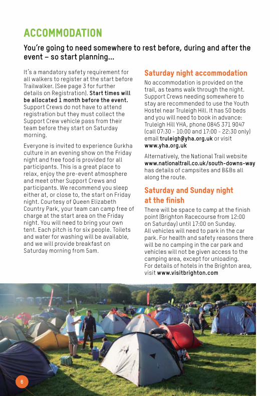
Everyone is invited to experience Gurkha culture in an evening show on the Friday night and free food is provided for all participants. This is a great place to relax, enjoy the pre-event atmosphere and meet other Support Crews and participants. We recommend you sleep either at, or close to, the start on Friday night. Courtesy of Queen Elizabeth Country Park, your team can camp free of charge at the start area on the Friday night. You will need to bring your own tent. Each pitch is for six people. Toilets and water for washing will be available, and we will provide breakfast on Saturday morning from 5am.
You’re going to need somewhere to rest before, during and after the event – so start planning...
Saturday night accommodation No accommodation is provided on the trail, as teams walk through the night. Support Crews needing somewhere to stay are recommended to use the Youth Hostel near Truleigh Hill. It has 50 beds and you will need to book in advance: Truleigh Hill YHA, phone 0845 371 9047 (call 07:30 - 10:00 and 17:00 - 22:30 only) email [email protected] or visit www.yha.org.uk
Alternatively, the National Trail website www.nationaltrail.co.uk/south-downs-way has details of campsites and B&Bs all along the route.
Saturday and Sunday night at the finishThere will be space to camp at the finish point (Brighton Racecourse from 12:00 on Saturday) until 17:00 on Sunday. All vehicles will need to park in the car park. For health and safety reasons there will be no camping in the car park and vehicles will not be given access to the camping area, except for unloading. For details of hotels in the Brighton area, visit www.visitbrighton.com
All materials used at Trailwalker are subject to Oxfam’s stringent ethical checks and we also source them locally whenever possible.
We’re making Trailwalker disposable cup free! A reusable water bottle or bladder is part of the compulsory kit list, but this year we are asking you to bring your own flasks for hot drinks. These can be kept by your Support Crew, ready for your arrival at the next check point. Water and hot drinks will remain available across the course at each checkpoint.
We’ll be using 100% compostable plates and cutlery. This means you can enjoy your meal whilst being a friend to the planet! Make sure you check out what food is available over the weekend on page 4 and plan ahead to avoid wastage.
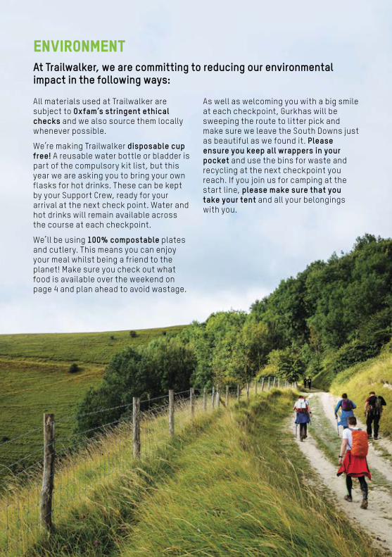
At Trailwalker, we are committing to reducing our environmental impact in the following ways:
Environment
As well as welcoming you with a big smile at each checkpoint, Gurkhas will be sweeping the route to litter pick and make sure we leave the South Downs just as beautiful as we found it. Please ensure you keep all wrappers in your pocket and use the bins for waste and recycling at the next checkpoint you reach. If you join us for camping at the start line, please make sure that you take your tent and all your belongings with you.

You must bring ALL of the equipment marked as compulsory on the kit list, and you’ll need to sign an equipment disclaimer form before taking part in the event.
We’ve split the kit list into compulsory team items, compulsory personal items (that must be kept on you at all times) and weather-dependent items that you must have available in your support vehicle. Make
sure that your team has checked off the team list together, and remember that each team member will need to take responsibility for all their own items on the personal list.
Please be aware that we have marked items as compulsory for your own safety – it is essential to be prepared for all weather conditions and know what to do if a team member needs to drop out.
PARTICIPANT kit list
1 x sturdy water bottle or bladder (full)
1 x head torch and spare batteries
2 x participant numbers (you’ll receive these at registration if not before)
1 x sun hat
1 x whistle
COMPULSORY ITEMS (ONE PER PERSON)
1 x Trailwalker Map and Event Guide
1 x Ordnance Survey Map (recommended Landranger OS 197 and 198)
1 x compass
1 x notebook and pen for recording details in an emergency
2 x mobile phones (for different networks)
1 x first aid kit
1 x survival bag
2 x high-visibility vests
1 x rucksack
1 x suncream
COMPULSORY per team
8

9
1 x warm hat and pair of gloves
1 x warm fleece
2 x sets of spare clothing (Carry one, keep one in the Support Crew vehicle)
Spare socks (We recommend at least four pairs. Carry one spare, others can be in the support vehicle)
1 x waterproof jacket and trousers
1 x mug
Weather-dependent items (per Individual – to be available in support vehicle)
Support Crew and your kiTDepending on the conditions, you may not need to carry all kit with you at all times. Use your Support Crew to transport spare dry clothing, and if it's a hot day, the warmer items for the night section. Many teams have been caught out on the course by rapidly changing weather - think carefully before setting off without waterproofs and ask your Support Crew to provide regular weather updates. There is a separate list in the Support Crew Guide with recommendations of what they should bring.
Teams should be reminded that it is their responsibility to conduct a weather check at each checkpoint and ensure that they have the necessary equipment to support themselves between each checkpoint.
Recommendedretail partner
Cotswold Outdoor is proud to be the official retailer for Oxfam Trailwalker 2021. Participants and Support Crew can enjoy a 15% discount* on clothing and equipment as well as free in-store boot and rucksack fitting services to help the kilometres pass by as comfortably and as pleasantly as possible. CODE: AF-TRAIL-21*Full T&Cs apply. Offer expires 30.09.21
STORES NATIONWIDE • COTSWOLDOUTDOOR.COM
10
how your fundraising helpsOxfam Oxfam is a global movement of millions of people working together to end poverty. By taking part in this event, you are helping to Oxfam to beat hunger, fight climate change, provide safe and clean water, respond to emergencies and support women and gender justice. More recently Oxfam has also been supporting in the fight against Coronavirus.
The Gurkha Welfare TrustWith your support, we continue to provide vital support to Gurkha veterans, their families and communities in Nepal.
We enable people to live with dignity by delivering essential financial and medical aid and work with local communities to provide access to clean water and education.
Our Pensioner Support Teams journey into the hills of Nepal on motorbikes, in 4x4 vehicles and on foot to pay a pension to Gurkha veterans and widows, check their health and deliver medication in their own homes. Last year we paid our pension to over 4,800 veterans and widows who have an average age of 80. With no entitlement to a British Army pension, for most this is their only source of income.
Your fundraising is first sent to Oxfam so it can be processed. Then it’s all added together and split between Oxfam and The Gurkha Welfare Trust.
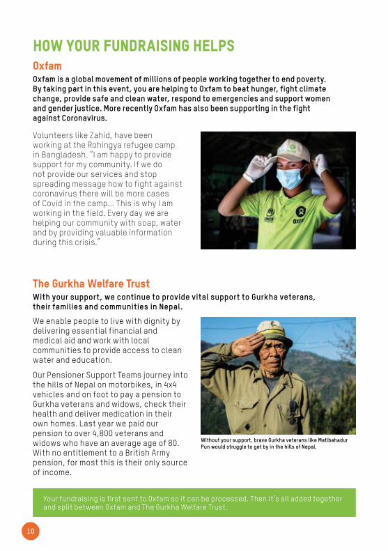
Volunteers like Zahid, have been working at the Rohingya refugee camp in Bangladesh. “I am happy to provide support for my community. If we do not provide our services and stop spreading message how to fight against coronavirus there will be more cases of Covid in the camp... This is why I am working in the field. Every day we are helping our community with soap, water and by providing valuable information during this crisis.”
Without your support, brave Gurkha veterans like Matibahadur Pun would struggle to get by in the hills of Nepal.
11
Training and Nutrition We cannot stress enough that you must train for Trailwalker. Head to the Trailwalker website to find a downloadable training guide including a plan, information on kit, medical care, route navigation and nutrition in the lead up to and over event weekend.
For now, here’s a list of milestones to help you get started on the road to success. Start fundraising as you start training. It’s much easier to reach your pledge if you give yourself time.
Go out for a short walk to check your boots fit well – buy new if needed.
Schedule team walks and planning sessions. Get your Support Crew involved. Consider linking these up with any fundraising events you might have.
Book transport and accommodation for the event weekend, if needed. Camping at the start area is free and doesn’t need to be booked.
Plan timings of the route. What time are you aiming for? When will you arrive at each checkpoint to meet your Support Crew?
Plan your kit bags. One to carry with you and another to leave with your Support Crew.
Plan and purchase all food and goodies for checkpoints. Plan your bag per checkpoint.
Remember to taper your training in the last two weeks; this is when you can carb load.
Make another push on your fundraising closer to the event. Provide your contacts with an update on your training, details of the work Oxfam and The Gurkha Welfare Trust is doing and the difference their donation will make.
Reach your fundraising pledge by event weekend.
Make sure your supporters know they can follow your progress online throughout the event.
12
Queen Elizabeth Country Park
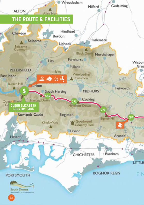
The route & facilities
SCP1
CP2
CP3
CP4
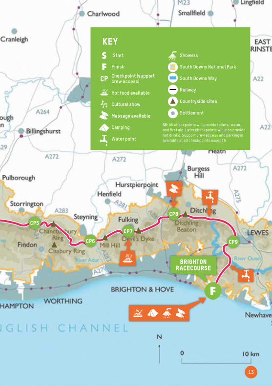
13
Brighton RaceCourse
f
CP5
CP6
CP7
CP8
CP9
KEY
NB: All checkpoints will provide toilets, water, and first aid. Later checkpoints will also provide hot drinks. Support Crew access and parking is available at all checkpoints except 5
CP
Start
Finish
Checkpoint (support crew access)
Hot food available
Cultural show
Massage available
Camping
Water point
Showers
South Downs National Park
South Downs Way
Railway
Countryside sites
Settlement
Sf
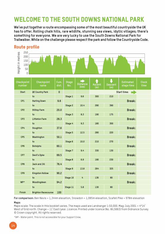
We’ve put together a route encompassing some of the most beautiful countryside the UK has to offer. Rolling chalk hills, rare wildlife, stunning sea views, idyllic villages; there’s something for everyone. We are very lucky to use the South Downs National Park for Trailwalker. While on the challenge please respect the park and follow the Countryside Code.
Welcome to the South Downs National Park
14
Route profile
For comparison: Ben Nevis = 1,344m elevation, Snowdon = 1,085m elevation, Scafell Pike = 978m elevation
Maps Maps scale: The scale in this booklet varies. The maps used are Landranger 1:50,000. Mag: July 2001 = 4º14’ West of Grid north. Change = 11’ East/year. Licence: Printed under licence (No. WL5663) from Ordnance Survey © Crown copyright. All rights reserved.
*WP - Water point. This is not accessible for your Support Crew.
Checkpoint number
Checkpoint name
Cum. dist.
Stage No.
Distance
(km)
Ascent
(m)
Descent
(m)
Estimated stage time
Clock time
Start QE Country Park 0 Start time:
to Stage 1 9.6 300 210
CP1 Harting Down 9.6 Break:to Stage 2 10.4 290 390
CP2 Hilltop Farm 20.0 Break:to Stage 3 8.3 190 175
CP3 Littleton Farm 28.3 Break:to Stage 4 9.3 180 300
CP4 Houghton 37.6 Break:to Stage 5 12.5 280 220
CP5 Washington 50.1 Break:to Stage 6 10.0 210 270
CP6 Botolphs 60.1 Break:to Stage 7 9.4 330 130
CP7 Devil’s Dyke 69.5 Break:to Stage 8 6.9 190 230
CP8 Jack and Jill 76.4 Break:to Stage 9 13.8 264 325
CP9 Kingston Hollow 90.2 Break:to Stage 10 4 136 80
WP* Woodingdean 94.2 Break:to Stage 11 5.8 130 80
Finish Brighton Racecourse 100
500
250200150100
Heig
ht in
Met
res
Fini
sh
WP
50
0
250200150100
Heig
ht in
Met
res
50
0
250200150100
Heig
ht in
Met
res
Heig
ht in
met
res

Part of this challenge is for your team to successfully navigate the course. To help you, the following maps have been designed to describe the route. They are not, however, a substitute for good navigation.
Maps & directions
Food and drinkCold drinks will be available at every checkpoint. Hot drinks will be available later in the course. Please take advantage of these, as it is vital to keep your body properly hydrated and nourished. First aid support will be available at every checkpoint for serious injuries, but please treat minor ailments, e.g. blisters, yourself. Water points are not accessible by car for Support Crew, as they are for just walkers to have a brief break.
Dogs Please do not bring your dogs to Trailwalker, even as part of a Support Crew. Landowners kindly allow us access to their land and dogs may scare their livestock so please leave your dogs at home.
Countryside Code Please be aware that over 4,000 people will be involved with Trailwalker, and that everyone should use the toilets, rubbish bins and recycling bins provided at the checkpoints. This event depends on the continued goodwill of local communities and others, so please be considerate and follow the Countryside Code.
Be safe - plan ahead and follow any signs or advice.
Leave gates and property as you find them.
Protect plants and animals and take your litter home (or to the next checkpoint or waterstop).
Consider other people - especially other walkers, landowners and local communities.
More info can be found at www.naturalengland.org.uk
Notices and correctionsAll maps, direction and figures are intended as a guide only. The course has been measured as 100km and whilst we have endeavoured to ensure that all information is correct at the time of printing, we cannot guarantee that any personal fitness trackers used over the event weekend will match our guide completely.
Each checkpoint is approximately 10km apart but please note that this varies and some sections are longer than 10km, particularly near the end. Due to the challenging landscape, we are unable to amend this so please plan ahead and review each section of the route carefully in the following pages.
Map readingIf you’re not sure where to start with map reading then have a look at the Ordnance Survey map reading tips online. www.ordnancesurvey.co.uk/resources/map-reading
Good luck!
It is essential that your team and Support Crew carry Ordnance Survey Maps 197 and 198 (1:50,000) and know how to read them. Do not rely on just one navigator, in case they drop out. Please note that for good reason we do not provide postcodes to use with your Support Crew’s sat nav. The checkpoints en route often use remote farm land which is notoriously bad to navigate using these devices. Please refer to OS maps for precise navigation.
The majority of the route is along the South Downs Way. Where the route leaves it, this is clearly indicated in the booklet. The South Downs Way is well signposted with the name and either green or blue arrows, so if you are in doubt, look for a sign.
15

16
1. From the start line, head down the paved road, keeping the buildings on your left.
2. At the turning circle, follow signs towards 'Forest Drive Car Parks'.
3. Turn off road towards ‘Bernham Bushes’ at road hairpin.
4. Continue on track. When main track merges from the right after 800m, bear left, then after 40m take the right hand fork over brow of hill.
5. Continue downhill for 700m to small car park.
6. Go straight across crossroads towards ‘Dean Barn’.
7. Road ends after 500m, continue on South Downs Way track to the left, keeping the hedge to your right.
8. After 1.2km join road, follow to T-junction and turn left.
9. Road bends left after 650m, as you pass Sunwood Farm on your right.
10. After bend turn right onto South Downs Way track.
11. At top of hill go straight on at track junction.
From: Start point (Queen Elizabeth Country Park) SU717 187 To: Checkpoint 1 (Harting Down) SU790 181
9.6KMStart Finish
stage 1
Distance: 9.6km Ascent: 300m Descent: 210m
Target Times 12 hrs: 1:09 18 hrs: 1:41
24 hrs: 2:18 30 hrs: 2:53
500
250200150100
Heig
ht in
Met
res
Start Point
CP 1
500
250200150100
Heig
ht in
Met
res
CP 1
CP 2
500
250200150100
Heig
ht in
Met
res
CP 2 CP
3
500
250200150100
Heig
ht in
Met
res
CP 3
CP 4
500
250200150100
Heig
ht in
Met
res
CP 4 CP 5
stage profile
12. Cross road after 1.2km.
13. Continue on track opposite, cross B2146 after 1.2km.
Danger – fast moving traffic.
14. Continue up track, after 600m, reach and cross B2141 road.
Danger – fast moving traffic.
Checkpoint 1 is just up track on opposite side.
THE CUT-OFF TIME FOR THIS CHECKPOINT IS 12:30 SAT. TO CONTINUE IN THE EVENT, ALL TEAMS MUST LEAVE THE CHECKPOINT BEFORE THIS TIME.
Target times (hrs) 12, 18, 24, 30 Estimated timings for teams attempting to complete the course within a target time. They are calculated using an average pace for each desired time. The calculations do not include time for stops on the route or at checkpoints and these should be factored in when planning your timing.
start
Checkpoint 1
Why not take a startline selfie and share it on Facebook, Instagram and Twitter with your fundraising link using #TrailwalkerStrong
Heig
ht in
met
res

17
1. Follow worn grass track to bridle gate.
2. Go over brow of hill and past small copse of trees on left.
3. As you descend, take the left path through the hedgerow.
4. Pass a signpost, go up very steep hill straight ahead, and pass through bridle gate.
5. After 200m, take left fork beside bushes onto grass track close to hilltop.
6. Do not go as far as the trig point on right. Go over brow of hill and 300m down far side.
Continue straight ahead, joining major track. Go up hill keeping wire fence on right.
Do not take grass track to left.
7. Go over brow of hill and down through arable land on grass track for 400m. Turn right onto the first track at signpost in corner of hedge.
8. Stay on the narrow track, hugging the edge of the field, follow track for 300m to far side.
9. At end of field, track veers left into trees.
10. After 300m track passes between fences for 250m to track T-junction, turn left.
11. Turn right after 25m onto track between hedges.
12. After 800m, pass gate on left-hand side (signed West Dean Estate). Continue on track into woodland.
13. After 600m reach cross tracks and turn left.
14. After 600m wire netting fence appears on right.
15. After 200m scrub woodlands ends. You are now in open land.
16. Continue for 4km, past barn complex on right.
17. Follow track to main road (A286) and cross road to track opposite.
Danger – fast moving traffic.
Checkpoint 2 is in field on right.
THE CUT-OFF TIME FOR THIS CHECKPOINT IS 16:00 Sat. TO CONTINUE IN THE EVENT, ALL TEAMS MUST LEAVE THE CHECKPOINT BEFORE THIS TIME.
From: Checkpoint 1 (Harting Down) SU790 181 To: Checkpoint 2 (Hilltop Farm) SU875 167
20KMStart Finish
stage 2
500
250200150100
Heig
ht in
Met
res
Start Point
CP 1
500
250200150100
Heig
ht in
Met
res
CP 1
CP 2
500
250200150100
Heig
ht in
Met
res
CP 2 CP
3
500
250200150100
Heig
ht in
Met
res
CP 3
CP 4
500
250200150100
Heig
ht in
Met
res
CP 4 CP 5
stage profile
Distance: 10.4km Ascent: 290m Descent: 390m
Target Times 12 hrs: 1:14 18 hrs: 1:52
24 hrs: 2:29 30 hrs: 3:07
Checkpoint 1
Checkpoint 2
Heig
ht in
met
res
18
From: Checkpoint 2 (Hilltop Farm) SU875 167 To: Checkpoint 3 (Littleton Farm) SU951 146
28.3KMStart Finish
stage 3
1. Go through gate at top of field and rejoin track.
2. Heading between buildings, go past ‘Manor Farm’ and through gate with ‘No Vehicular Access’ sign.
3. After 1km pass woodland on right and follow track for 2km with woodland on right, ignoring footpath to the left.
4. After sharp left and right bends within 10m of each other, track enters woodland. Continue straight for 3km, along South Downs Way.
5. At end of woods go straight on at major track crossroads, along South Downs Way for Upper Waltham.
6. Continue straight along South Downs Way, track across arable land.
7. After 1.6km reach track crossroads and continue straight on into scrub and woodland.
8. After 300m go through gateway, and head straight across arable field (compass bearing 140°)
9. Go through bridle gate for 500m, to second bridle gate.
10. Go through second bridal gate into trees, and turn left. After 25m turn right into top of field. Checkpoint 3 is in the field.
THE CUT-OFF TIME FOR THIS CHECKPOINT IS 18:30 Sat. TO CONTINUE IN THE EVENT, ALL TEAMS MUST LEAVE THE CHECKPOINT BEFORE THIS TIME.
500
250200150100
Heig
ht in
Met
res
Start Point
CP 1
500
250200150100
Heig
ht in
Met
res
CP 1
CP 2
500
250200150100
Heig
ht in
Met
res
CP 2 CP
3
500
250200150100
Heig
ht in
Met
res
CP 3
CP 4
500
250200150100
Heig
ht in
Met
res
CP 4 CP 5
stage profile
Distance: 8.3km Ascent: 190m Descent: 175m
Target Times 12 hrs: 1:00 18 hrs: 1:30
24 hrs: 2:00 30 hrs: 2:30
Checkpoint 2
Checkpoint 3
Heig
ht in
met
res
19
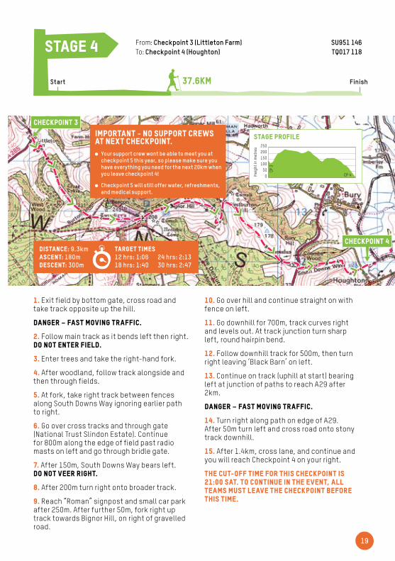
1. Exit field by bottom gate, cross road and take track opposite up the hill.
Danger – fast moving traffic.
2. Follow main track as it bends left then right.Do not enter field.
3. Enter trees and take the right-hand fork.
4. After woodland, follow track alongside and then through fields.
5. At fork, take right track between fences along South Downs Way ignoring earlier path to right.
6. Go over cross tracks and through gate (National Trust Slindon Estate). Continue for 800m along the edge of field past radio masts on left and go through bridle gate.
7. After 150m, South Downs Way bears left. Do not veer right.
8. After 200m turn right onto broader track.
9. Reach “Roman” signpost and small car park after 250m. After further 50m, fork right up track towards Bignor Hill, on right of gravelled road.
10. Go over hill and continue straight on with fence on left.
11. Go downhill for 700m, track curves right and levels out. At track junction turn sharp left, round hairpin bend.
12. Follow downhill track for 500m, then turn right leaving ‘Black Barn’ on left.
13. Continue on track (uphill at start) bearing left at junction of paths to reach A29 after 2km.
Danger – fast moving traffic.
14. Turn right along path on edge of A29. After 50m turn left and cross road onto stony track downhill.
15. After 1.4km, cross lane, and continue and you will reach Checkpoint 4 on your right.
THE CUT-OFF TIME FOR THIS CHECKPOINT IS 21:00 Sat. TO CONTINUE IN THE EVENT, ALL TEAMS MUST LEAVE THE CHECKPOINT BEFORE THIS TIME.
500
250200150100
Heig
ht in
Met
res
Start Point
CP 1
500
250200150100
Heig
ht in
Met
res
CP 1
CP 2
500
250200150100
Heig
ht in
Met
res
CP 2 CP
3
500
250200150100
Heig
ht in
Met
res
CP 3
CP 4
500
250200150100
Heig
ht in
Met
res
CP 4 CP 5
stage profile
From: Checkpoint 3 (Littleton Farm) SU951 146 To: Checkpoint 4 (Houghton) TQ017 118
37.6KMStart Finish
stage 4
Distance: 9.3km Ascent: 180m Descent: 300m
Target Times 12 hrs: 1:06 18 hrs: 1:40
24 hrs: 2:13 30 hrs: 2:47
Checkpoint 3
Checkpoint 4
Heig
ht in
met
res
IMPORTANT - No Support Crews at next checkpoint.
Your support crew wont be able to meet you at checkpoint 5 this year, so please make sure you have everything you need for the next 20km when you leave checkpoint 4!
Checkpoint 5 will still offer water, refreshments, and medical support.

20
From: Checkpoint 4 (Houghton) TQ017 118 To: Checkpoint 5 (Washington) TQ109 108
50.1KMStart Finish
stage 5
1. Exit checkpoint and follow directions towards the river; turn right along river.
2. Cross the bridge and turn right on the other side of the river.
3. After 190m, turn left through gate. Follow track round to right, cross railway bridge and go down to main road.
4. Turn right along footpath and after 100m, cross road at the South Downs Way signpost. Follow path on opposite side of road for 100m then turn LEFT following road uphill (‘High Titten’ Road).
5. After 600m, follow road right at fork, then take path left after 60m, as road bends right.
6. Reach bridle gate after 20m, wire fence each side.
7. Go straight up steep hill ignoring track on right. Cross gate after 400m.
8. Straight on for 1km passing trig point on right, and after 800m pass through clump of trees. After 800m continue past small car park.
9. Straight on for 1.7km to road with signpost marked ‘Chantry’. Continue on track towards Washington and into fields after 90m.
10. After 700m, take right fork just after the old barn, leaving the South Downs Way.
11. After 750m bear right at track junction to keep woodland on your left, then follow track past the woods and through a field.
12. Continue to follow track as it turns left 450m after the woodland.
13. As you pass through the row of trees, turn left at track junction, then after 50m turn right into field and follow grassy path to checkpoint 5.
THE CUT-OFF TIME FOR THIS CHECKPOINT IS 00:30 Sun. TO CONTINUE IN THE EVENT, ALL TEAMS MUST LEAVE THE CHECKPOINT BEFORE THIS TIME.
500
250200150100
Heig
ht in
Met
res
Start Point
CP 1
500
250200150100
Heig
ht in
Met
res
CP 1
CP 2
500
250200150100
Heig
ht in
Met
res
CP 2 CP
3
500
250200150100
Heig
ht in
Met
res
CP 3
CP 4
500
250200150100
Heig
ht in
Met
res
CP 4 CP 5
stage profile
Distance: 12.5km Ascent: 280m Descent: 220m
Target Times 12 hrs: 1:30 18 hrs: 2:15
24 hrs: 3:00 30 hrs: 3:46
Checkpoint 4
Checkpoint 5
You're halfway! Share your fundraising link and let your sponsors know your progress!
Heig
ht in
met
res
21
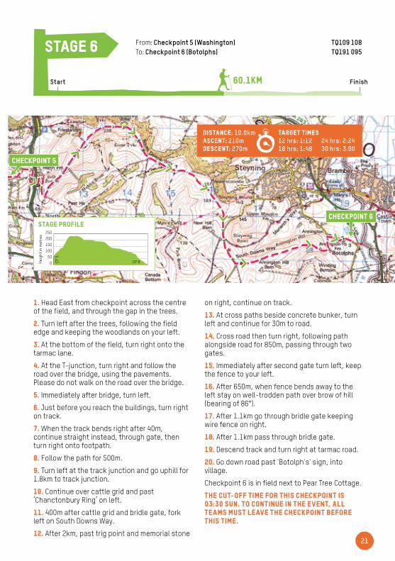
1. Head East from checkpoint across the centre of the field, and through the gap in the trees.
2. Turn left after the trees, following the field edge and keeping the woodlands on your left.
3. At the bottom of the field, turn right onto the tarmac lane.
4. At the T-junction, turn right and follow the road over the bridge, using the pavements. Please do not walk on the road over the bridge.
5. Immediately after bridge, turn left.
6. Just before you reach the buildings, turn right on track.
7. When the track bends right after 40m, continue straight instead, through gate, then turn right onto footpath.
8. Follow the path for 500m.
9. Turn left at the track junction and go uphill for 1.8km to track junction.
10. Continue over cattle grid and past ‘Chanctonbury Ring’ on left.
11. 400m after cattle grid and bridle gate, fork left on South Downs Way.
12. After 2km, past trig point and memorial stone
on right, continue on track.
13. At cross paths beside concrete bunker, turn left and continue for 30m to road.
14. Cross road then turn right, following path alongside road for 850m, passing through two gates.
15. Immediately after second gate turn left, keep the fence to your left.
16. After 650m, when fence bends away to the left stay on well-trodden path over brow of hill (bearing of 86°).
17. After 1.1km go through bridle gate keeping wire fence on right.
18. After 1.1km pass through bridle gate.
19. Descend track and turn right at tarmac road.
20. Go down road past 'Botolph's' sign, into village.
Checkpoint 6 is in field next to Pear Tree Cottage.
THE CUT-OFF TIME FOR THIS CHECKPOINT IS 03:30 Sun. TO CONTINUE IN THE EVENT, ALL TEAMS MUST LEAVE THE CHECKPOINT BEFORE THIS TIME.
500
250200150100
Heig
ht in
Met
res
CP 6CP 5
500
250200150100
Heig
ht in
Met
res
CP 7CP 6
500
250200150100
Heig
ht in
Met
res
CP 8CP
7
500
250200150100
Heig
ht in
Met
res
CP 9CP
8
500
250200150100
Heig
ht in
Met
res
CP 10CP 9
stage profile
From: Checkpoint 5 (Washington) TQ109 108 To: Checkpoint 6 (Botolphs) TQ191 095
60.1KMStart Finish
stage 6
Distance: 10.0km Ascent: 210m Descent: 270m
Target Times 12 hrs: 1:12 18 hrs: 1:48
24 hrs: 2:24 30 hrs: 3:00
Checkpoint 5
Checkpoint 6
Heig
ht in
met
res
22
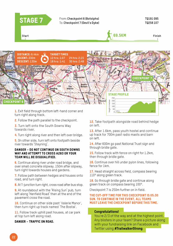
1. Exit field through bottom left-hand corner and turn right along track.
2. Follow the path parallel to the checkpoint.
3. Turn left onto the South Downs Way towards river.
4. Turn right along river and then left over bridge.
5. On other side, turn left onto footpath beside river towards ‘Steyning’.
DANGER – Do not continue on South Downs Way and attempt to cross A283 or your team will be disqualified.
6. Continue along river under road bridge, and over small concrete slipway. 150m after slipway, turn right towards houses and gardens.
7. Follow path between hedges and houses onto road, and turn right.
8. At T-junction turn right, cross road after bus stop.
9. At roundabout with the ‘Rising Sun’ pub, turn left along ‘Henfield Road’ then at the end of the pavement cross the road.
10. Continue on other side past 'Valerie Manor', then turn right up track named 'The Bostal'.
11. Follow track uphill past houses, at car park at top turn left along road.
DANGER – traffic on road.
12. Take footpath alongside road behind hedge on left.
13. After 1.6km, pass youth hostel and continue up track for 700m past radio masts and barn on left.
14. After 600m go past National Trust sign and through bridle gate.
15. Follow track with fence on right for 1.2km, then through bridle gate.
16. Continue over hill under pylon lines, following fence for 1km.
17. Head straight across field, compass bearing 110º along green track.
18. Go through bridle gate and continue along green track on compass bearing 100º.
Checkpoint 7 is 250m further on in field.
THE CUT-OFF TIME FOR THIS CHECKPOINT IS 05:30 Sun. TO CONTINUE IN THE EVENT, ALL TEAMS MUST LEAVE THE CHECKPOINT BEFORE THIS TIME.
500
250200150100
Heig
ht in
Met
res
CP 6CP 5
500
250200150100
Heig
ht in
Met
res
CP 7CP 6
500
250200150100
Heig
ht in
Met
res
CP 8CP
7
500
250200150100
Heig
ht in
Met
res
CP 9CP
8
500
250200150100
Heig
ht in
Met
res
CP 10CP 9
stage profile
From: Checkpoint 6 (Botolphs) TQ191 095 To: Checkpoint 7 (Devil's Dyke) TQ258 107
69.5KMStart Finish
stage 7
Distance: 9.4km Ascent: 330m Descent: 130m
Target Times 12 hrs: 1:07 18 hrs: 1:41
24 hrs: 2:15 30 hrs: 2:49
Checkpoint 6
Checkpoint 7
Congratulations!You're 2/3 of the way and at the highest point. Any blisters in your team? Share a picture along with your fundraising link on Facebook and Twitter using #TrailwalkerStrong
Heig
ht in
met
res

23
1. Leave field by bridle gate, cross road and go through second bridle gate. DANGER – Busy road and Support Crews entering field.
2. Follow main track, bearing left at junction.
3. Continue through bridle gate for 1.1km, parallel to, and sometimes close to, road on right. At open area 30m before car park, follow track left.
4. After 200m, pass covered reservoir (surrounded by iron fence).
5. Go down steep track for 300m to road and cross over to track signed ‘Saddlescombe Farm’.
DANGER – fast-moving traffic.
6. Pass house on right and go through bridle gate straight ahead, signed ‘New Timber Hill’.
7. Join broad track heading right, continue through gate and pass cottages and barns on main track.
8. After passing cottages take the wooden bridle gate marked South Downs Way; follow tree-covered sunken track (do not enter field on left).
9. After 200m, find two bridle gates. Take left bridle gate, go uphill for 650m keeping fence on right.
10. Go through bridle gate at top of field and go straight on.
11. Follow track downhill, keeping fence on right. After 1km, go through bridle gate and continue down track.
12. Go through bridle gate and pass farm on left.
13. After the farm, turn left onto the slip road towards the road bridge over the A23.
14. Turn right over road bridge using the pavement.
15. Cross bridge; on other side turn right at flower box and ‘Church Hill’ sign.
16. Follow road uphill, go straight on down 'School Lane' after passing church.
17. At T-junction with major road turn left along footpath beside road.
18. After 200m, cross road and turn right up track past 'Pyecombe Golf Club'. Track continues between two halves of golf course.
19. After 1.1km, pass through bridle gate. Golf course ends on right.
20. After 30m reach cross tracks. Turn left through bridle gate along South Downs Way, past farm buildings. Do not go straight on.
21. At track junction go straight on towards windmills.
22. After 125m turn right through small gap in hedge.
Checkpoint 8 is in field through gate immediately on right.
THE CUT-OFF TIME FOR THIS CHECKPOINT IS 07:30 Sun. TO CONTINUE IN THE EVENT, ALL TEAMS MUST LEAVE THE CHECKPOINT BEFORE THIS TIME.
From: Checkpoint 7 (Devil's Dyke) TQ258 107 To: Checkpoint 8 (Jack and Jill) TQ304 133
76.4KMStart Finish
stage 8
500
250200150100
Heig
ht in
Met
res
CP 6CP 5
500
250200150100
Heig
ht in
Met
res
CP 7CP 6
500
250200150100
Heig
ht in
Met
res
CP 8CP
7
500
250200150100
Heig
ht in
Met
res
CP 9CP
8
500
250200150100
Heig
ht in
Met
res
CP 10CP 9
stage profile
Distance: 6.9km Ascent: 190m Descent: 230m
Target Times 12 hrs: 0:49 18 hrs: 1:14
24 hrs: 1:39 30 hrs: 2:04
Checkpoint 7
Checkpoint 8
Heig
ht in
met
res
24
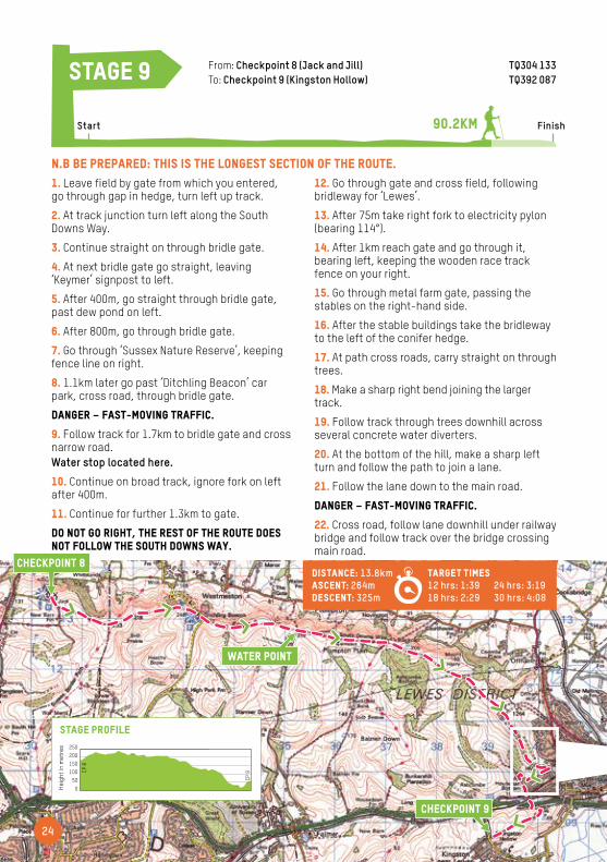
1. Leave field by gate from which you entered, go through gap in hedge, turn left up track.
2. At track junction turn left along the South Downs Way.
3. Continue straight on through bridle gate.
4. At next bridle gate go straight, leaving ‘Keymer’ signpost to left.
5. After 400m, go straight through bridle gate, past dew pond on left.
6. After 800m, go through bridle gate.
7. Go through ‘Sussex Nature Reserve’, keeping fence line on right.
8. 1.1km later go past ‘Ditchling Beacon’ car park, cross road, through bridle gate.
DANGER – fast-moving traffic.
9. Follow track for 1.7km to bridle gate and cross narrow road. Water stop located here.
10. Continue on broad track, ignore fork on left after 400m.
11. Continue for further 1.3km to gate.
Do not go right, the rest of the route does not follow the South Downs Way.
12. Go through gate and cross field, following bridleway for ‘Lewes’.
13. After 75m take right fork to electricity pylon (bearing 114°).
14. After 1km reach gate and go through it, bearing left, keeping the wooden race track fence on your right.
15. Go through metal farm gate, passing the stables on the right-hand side.
16. After the stable buildings take the bridleway to the left of the conifer hedge.
17. At path cross roads, carry straight on through trees.
18. Make a sharp right bend joining the larger track.
19. Follow track through trees downhill across several concrete water diverters.
20. At the bottom of the hill, make a sharp left turn and follow the path to join a lane.
21. Follow the lane down to the main road.
DANGER – fast-moving traffic.
22. Cross road, follow lane downhill under railway bridge and follow track over the bridge crossing main road.
From: Checkpoint 8 (Jack and Jill) TQ304 133 To: Checkpoint 9 (Kingston Hollow) TQ392 087
90.2KMStart Finish
stage 9
500
250200150100
Heig
ht in
Met
res
WPCP 9
500
250200150100
Heig
ht in
Met
res
CP 9CP
8
stage profile
Distance: 13.8km Ascent: 264m Descent: 325m
Target Times 12 hrs: 1:39 18 hrs: 2:29
24 hrs: 3:19 30 hrs: 4:08
Checkpoint 8
Checkpoint 9
N.B Be prepared: this is the longest section of the route.
water point
Heig
ht in
met
res
25
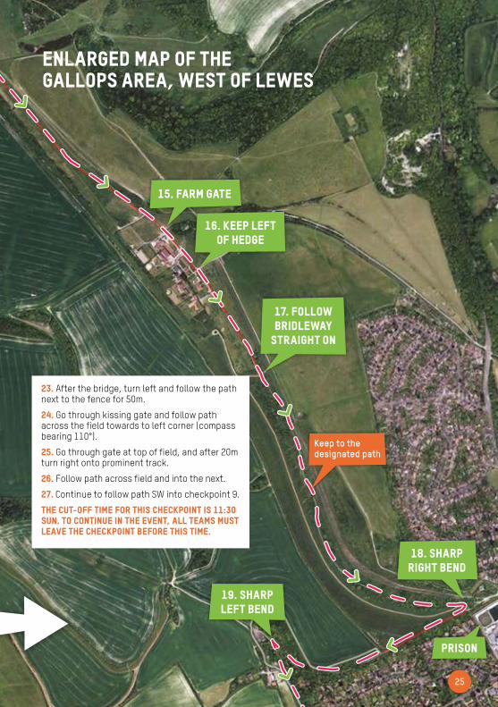
Enlarged map of the Gallops area, West of Lewes
15. Farm gate
16. Keep left of hedge
17. Follow bridleway
straight on
18. Sharp right bend
19. Sharp left bend
Prison
Keep to the designated path
23. After the bridge, turn left and follow the path next to the fence for 50m.
24. Go through kissing gate and follow path across the field towards to left corner (compass bearing 110°).
25. Go through gate at top of field, and after 20m turn right onto prominent track.
26. Follow path across field and into the next.
27. Continue to follow path SW into checkpoint 9.
THE CUT-OFF TIME FOR THIS CHECKPOINT IS 11:30 Sun. TO CONTINUE IN THE EVENT, ALL TEAMS MUST LEAVE THE CHECKPOINT BEFORE THIS TIME.

26
1. Exit checkpoint through wooden gate and follow track to the road.
DANGER – fast-moving traffic.
2. Cross the road and follow the private road.
3. At the end of the road follow prominent track; after metal gate take first track left, continue to top of hill.
4. At the top of the hill turn left through wooden gate.
5. Continue for 100m, turn right, cross cattle grid and head downhill (south easterly direction).
6. At barn on right track ends, go through bridle gate to left.
7. Track continues down valley on compass bearing 250°. Follow valley as it curves around to the left then right, and then go through bridle gate.
8. Go 300m through arable field then through bridle gate.
9. Go 400m through another arable field and through bridle gate to barn. Go through gate on left on to track. Water point is 300m further on, just before cross tracks and small copse of trees.
THE CUT-OFF TIME FOR THIS water point IS 14:00 Sun. TO CONTINUE IN THE EVENT, ALL TEAMS MUST LEAVE THE water point BEFORE THIS TIME.
From: Checkpoint 9 (Kingston Hollow) TQ392 087 To: Water point (Woodingdean) TQ378 059
94.2KMStart Finish
stage 10
500
250200150100
Heig
ht in
Met
res
WPCP 9
500
250200150100
Heig
ht in
Met
res
CP 9CP
8
stage profile
Distance: 4km Ascent: 136m Descent: 150m
Target Times12hrs: 0:2818hrs: 0:4324hrs: 0:5730hrs: 1:12
Checkpoint 9
water point
PLEASE NOTE THERE IS NO Support Crew ACCESS AT the Water Point.
Heig
ht in
met
res
27
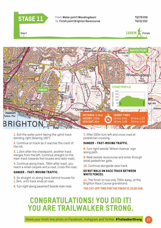
1. Exit the water point taking the uphill track bending right (bearing 160°).
2. Continue on track as it reaches the crest of the hill.
3. 1.2km after the checkpoint, another track merges from the left. Continue straight on the main track towards the houses and radio mast.
4. Continue along track, 700m after mast, you reach a small carpark and a road. Cross the road.
DANGER – fast-moving traffic.
5. Go straight on along track behind houses for 1.3km, until track ends at road.
6. Turn right along pavement beside main road.
From: Water point (Woodingdean) TQ378 059 To: Finish point Brighton Racecourse TQ332 052
100KMStart
stage 11
500
250200150100
Heig
ht in
Met
res
Fini
sh
WP
50
0
250200150100
Heig
ht in
Met
res
50
0
250200150100
Heig
ht in
Met
res
stage profile
Finish
7. After 200m turn left and cross road at pedestrian crossing.
DANGER – fast-moving traffic.
8. Turn right beside ‘Wilson Avenue’ sign along path.
9. Walk beside racecourse and enter through small pedestrian gate.
10. Continue alongside race track.
Do not walk on race track between white fences.
11. The finish is now only 700m away, at the Brighton Race Course grandstand.
THE CUT-OFF TIME FOR THE FINISH IS 16:00 Sun.
Congratulations! You did it! You are Trailwalker strong.
Distance: 5.8km Ascent: 130m Descent: 80m
Target Times 12 hrs: 0:41 18 hrs: 1:02
24 hrs: 1:23 30 hrs: 1:44
water point
finish
Share your finish line photo on Facebook, Instagram and Twitter. #TrailwalkerStrong
Heig
ht in
met
res
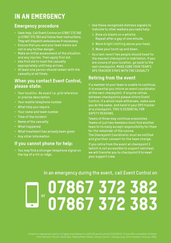
In an emergency
Oxfam is a registered charity in England and Wales (no 202918) and Scotland (SC039042). Oxfam GB is a member of Oxfam International. Photos: David Azia, Fabeha Monir/Oxfam, James Cannon, Sidregurung, Simon Rawles. Inhouse: 9501
Emergency procedure• Seek help. Call Event Control on 07867 372 382 or 07867 372 383 and follow their instructions. They will dispatch ambulances if necessary.• Ensure that you and your team mates are not in any further danger.• Make an initial assessment of the situation and any injuries. Then apply first aid.• Use first aid to treat the casualty appropriately until help arrives. • At least one person should remain with the casualty at all times.
When you contact Event Control, please state:• Your location. Be exact i.e. grid reference or precise description • Your mobile telephone number • What help you require • Your name and team number • Time of the incident • Name of the casualty • What happened • What treatment has already been given • Any other information
If you cannot phone for help:• You may find a stronger telephone signal on the top of a hill or ridge.
• Use these recognised distress signals to indicate to other walkers you need help:
1. Blow six blasts on a whistle. Repeat after a gap of one minute.
2. Wave bright clothing above your head.
3. Wave your torch up and down.
• As a last resort two people should head for the nearest checkpoint or habitation. If you are unsure of your location, go back to the last checkpoint. MAKE SURE YOUR TEAM'S GPS TRACKER STAYS WITH THE CASUALTY
Retiring from the eventIf a member of your team is unable to continue, it is essential you inform an event coordinator at the next checkpoint. If anyone retires between checkpoints please inform Event Control. If a whole team withdraws, make sure you do the same, and hand in your GPS tracker at a checkpoint. THIS IS ESSENTIAL FOR SAFETY REASONS.
Teams of three may continue unassisted. Teams of just two members must find another team to formally accept responsibility for them for the remainder of the course. The Checkpoint Coordinator must be notified and give their consent for the team change.
If you retire from the event at checkpoint 5 (which is not accessible to support vehicles), we will transfer you to checkpoint 6 to meet your support crew.
In an emergency during the event, call Event Control on
or07867 372 38207867 372 383