4.3 existing road conditions based on inventory
TRANSCRIPT

Final Report The Study on the Road Network Development in the Kingdom of Cambodia October 2006
MP-A-4-21
4.3 Existing Road Conditions Based On Inventory
The road inventory condition in this section is based on the following:
1) MPWT Location Referencing and Condition Survey (LRCS) completed in November 2004 as a component of the World Bank Road Rehabilitation Project under Credit No. 3181-KH.
2) MPWT National and Provincial Road Inventory, Department of Road Infrastructure and Provincial Department of Public Works and Transport
3) Public Works Research Center, GIS Mapping, MPWT 4) MPWT Cambodia Road Network Map (JICA, GIS) 5) MRD Provincial Road Level Inventory, 2005. 6) Study Team Collected As-Built Drawings, Contract/Design Drawings, other related
information of completed projects and on-going projects 7) Study Team Collected Design Drawings of committed projects 8) Study Team Road and Bridge Inventory
4.3.1 Limitation on Road Inventory Data in Cambodia
It is the intention of this study to cover, as much as possible, the road network under the jurisdiction of MPWT (for the national and provincial roads) and MRD (for the rural roads) for the preparation of the Master Plan. The study will thus utilize available road inventory and condition data provided by both MPWT and MRD and that conducted by the Study Team.
However, although both ministries are exerting considerable efforts to complete and improve the road network inventory, the data on road inventory is still far from being complete and accurate. It is noted that even in other countries such road inventory are still in the stage of development.
The available road inventory data in Cambodia will be utilized and efforts will be extended to supplement the data with additional surveys and investigation. An examination of the road network inventory under MPWT’s jurisdiction is presented in Table 4.3.1.
Table 4.3.1 Road Inventory by MPWT
Road Length (km)
Road Classification MPWT Road Network
Map (GIS), 2003
Department of Road Infrastructure
(DRI), 2004 Inventory
LRCS Project
Inventory, 2004
1-Digit National Road 1,988 2,052 1,988
2-Digit National Road 2,177 2,752 2,410
Reg. I 1,470 3,017
Reg. II 955 2,437 Provincial
Roads Reg. III 1,130
3,555
2,106
7,560 6,714
Total Length 7,720 12,364 11,112

Final Report The Study on the Road Network Development in the Kingdom of Cambodia October 2006
MP-A-4-22
The following differences in the inventory are noted:
• 1-Digit National Road : DRI Inventory included the new 64km NR.8
• 2-Digit National Road: DRI included additional road network from GIS Map while LRCS conducted actual road length and condition survey on limited road sections. Some road sections in the DRI inventory are inaccessible.
• Provincial Roads: Similarly new provincial roads were added by DRI in the Inventory while LRCS conducted actual road length and condition survey also on limited road sections. Similarly, some of the road sections in the DRI inventory are inaccessible.
Although not all roads included in the DRI Inventory were accessed by LRCS survey, LRCS data base contains more information concerning road condition and road length than the DRI Inventory. For this reason, the present study will utilize the data obtained from LRCS survey of 2004 as the basis of the present road network. Additional information was gathered by the Study Team including as-built and design drawings of various road projects and additional survey of NR.66, NR.76 and PR.216.
MRD conducted its road inventory at the provincial level in 2005 with road classification into Tertiary and Sub-Tertiary 1, 2, and 3. The total road length inventory for rural roads is taken as 18,948km.
It should be noted that the inventory contained in this study is still far from being complete since MPWT and MRD Road Inventory are still in the process of development.
4.3.2 Road Inventory and Condition
The distribution of road lengths for national, provincial (covers 3-Digit and 4-Digit roads as included in the LRCS survey) and rural, based on the LRCS, MPWT and MRD Inventory data, is shown in Table 4.3.2. The unpaved roads include those routes that are undergoing construction and committed for construction. Moreover, data provided by MPWT includes national road NR.8 from NR.11 at Ou Rang Ov to Prek Tamak connecting NR.6.
Table 4.3.2 Road Length Distribution in Cambodia
Road Classification Paved Road (km) Unpaved Road (km) Total (km)
1-Digit National 1,509 (73.5%) 543 (26.5%) 2,052*
2-Digit National 526 (19.9%) 2,117 (80.1%) 2,643
Provincial (3&4 -Digit)** 109 (1.6%) 6,506 (98.4%) 6,615
Rural Road 63 (0.3%) 18,885 (99.7%) 18,948
Total (km) 2,241 (7.4%) 28,017 (92.6%) 30,258 (100%)
*Includes 64.1km NR.8 Source: LRCS Inventory, 2004 and MRD Inventory **In this Study, Provincial Roads include 3-Digit and 4-Digit roads surveyed under the LRCS Inventory

Final Report The Study on the Road Network Development in the Kingdom of Cambodia October 2006
MP-A-4-23
The distribution of paved and unpaved roads for national and provincial roads is presented in Figure 4.3.1. Almost 73.5% of the 1-Digit roads are paved with most of the remaining unpaved section either under construction or committed for construction. On the contrary, only 19.9% of the 2-Digit national road is paved with the rest unpaved. Moreover, only 1.6% of the provincial road is paved while rural roads are practically unpaved.
Distribution of Paved and Unpaved Road on National andProvincial Roads
1,5092,117
6,506
18,885
63526 109
543
0
2,000
4,000
6,000
8,000
10,000
12,000
14,000
16,000
18,000
20,000
1-Digit NationalRoad
2-Digit NationalRoad
Provincial Road Rural Road
Road Classification
Roa
d Le
ngth
(km
)
Unpaved
Paved
Figure 4.3.1 Pavement Distribution for National and Provincial Roads
(1) 1-Digit National Road
In Table 4.3.3, the pavement types distribution for the 1-Digit national roads are presented, assuming all improvement works are completed. The table includes on-going projects and committed projects for the primary national road. It can be seen that once these projects are completed, 32.9% will have asphalt concrete pavement and 63.9% will be DBST. However, 183.0km of NR.2 and NR.3 will need future rehabilitation. Moreover, the remaining unpaved sections of the primary national road are basically NR.8 and a small section of NR.6 (due to historical bridge issues).
The following describes briefly the condition of the primary national roads:
[NR.1] - Section between PK 5.6 and PK 61.1 will be improved with asphalt concrete pavement by
Japan grant aid project. The road section will have 2-lane carriageway (7.0 m) except 1.8 km long of 4-lanes at beginning section, and paved shoulder (2.5 m) on both sides for motorbike running.
- Section between PK 62.1 and PK167.1 was rehabilitated with DBST pavement by ADB loan project. The road section will have 2-lane carriageway (7.5 m) and paved shoulder (1.5 m) on both sides.

Final Report The Study on the Road Network Development in the Kingdom of Cambodia October 2006
MP-A-4-24
- A bridge of 149.6 m long with 7.7 m width located at PK 66.3 is narrow than the roadway.
Table 4.3.3 Pavement Type Distribution for Primary National Roads After Completion of On-going Works
Road No. Asphalt DBST DBST*
(fair) Laterite Earth Total Remarks
NR.1 79.1 87.1 0.0 0.0 0.0 166.2 Includes 56km Japan Grant Section
NR.2 57.8 14.3 47.9 0.0 0.0 120.0 Includes 51.7km Japan Non-Project Fund Section (On-going)
NR.3 12.8 54.3 135.2 0.0 0.0 202.3 Includes 32.8km Korean Fund Section (On-going)
NR.4 214.2 0.0 0.0 0.0 0.0 214.2
NR.5 59.8 346.7 0.0 0.0 0.0 406.5 Includes 47.3km ADB Fund Section (Under Tender)
NR.6 190.0 223.4 0.0 2.1 0.0 415.5 Includes 98.2km ADB Fund Section (Under Tender)
NR.7 61.1 402.4 0.0 0.0 0.0 463.5 Includes 192.8km China Fund Section (On-going; new alignment shorter than existing)
NR.8 0.0 0.0 0.0 22.4 41.7 64.1 New 1-Digit national road
Total 674.8 (32.9%)
1,128.2 (55.0%)
183.0 (8.9%)
24.5(1.2%)
41.7(2.0%)
2,052.3100.0%
Source: As-Built Drawings, Design Drawings and Tender Drawings Collected by Study Team *This will need future rehabilitation due to present condition.
[NR.2]
- On the section between PK11.0 and PK 74.1, the rehabilitation and repairing by ADB loan was implemented. Sections of 11.1 km have 2-lane carriageway (7.0 m) without paved shoulder by DBST, and the pavement surface conditions on for other section are fair with 5 m to 7 m width to be required rehabilitation.
- Most bridges on the above section are temporary bailey bridge or narrow than the roadway, and 21 location of box culverts are less than 7.0 m width.
- Sections between PK11.0 and PK 11.2, and PK14.3 and PK 14.7 will be rehabilitated by Japan grant aid project (Bridge Rehabilitation Project). These sections will be improved as 2-lane carriageway (7.5 m) and paved shoulder (1.5 m) on both sides by asphalt concrete pavement.
- Section between PK 74.1 and PK1257 are being rehabilitated with asphalt pavement by Japan non-project fund project. The road section will have 2-lane carriageway (7.5 m) and paved shoulder (1.5 m) on both sides.
[NR.3]
- Section between PK12.6 and PK148.0 was repaired by WB loan (Flood Emergency Rehabilitation Project), where pavement surface of 5 m to 7 m width are narrow and fair conditions will be required for future rehabilitation.
Final Report The Study on the Road Network Development in the Kingdom of Cambodia October 2006
MP-A-4-25
- Many bridges and culverts on the said section are fair with narrow sections. Note that the section between PK 55.6 and PK 55.8 will be rehabilitated by Japan grant aid project (Bridge Rehabilitation Project), and will be improved as 2-lane carriageway (7.5 m) and paved shoulder (1.5 m) on both sides by asphalt concrete pavement.
- Section between PK148.0 and PK180.8 are being rehabilitated by Korea Loan and section between PK180.8 and PK202.3 was repaired by WB loan (Road Rehabilitation Project). The road section will have 2-lane carriageway (7.5 m) and paved shoulder (1.5 m) on both sides.
[NR.4]
- All section was rehabilitated with 2-lane carriageway (7.0 m) of asphalt concrete pavement by US grant aid project. Up to PK 45.6, hard shoulders of 1.5 m width are provided on the both sides.
- Roadway width of bridge is 8.0 m to 9.0 m.
[NR.5]
- Except 1.1 km section in Phnom Penh, the carriageway of NR.5 is 2-lane of 7.0 m wide. Pavement type on sections up to PK 12.6 and between PK359.3 and 406.5 (end point) is asphalt concrete, and section between PK 12.6 and PK 359.3 is DBST. Sections between PK 92.0 and PK171.0, and PK303.9 and PK359.3 are not provided with paved shoulder for space of motorbike running.
- On section up to PK359.3, the narrow and fair condition bridges and culverts remains at. 10 bridge locations with total length 335.3 m and 7 locations of box culverts are less than 7.0 m of road width unlike the width of carriageway .
[NR.6]
- NR.6 has 2-lane carriageway of 7.0 m width. For the pavement type, 190.0 km long section is asphalt concrete including on-going ADB loan between PK319.6 and PK417.8, and 223.6 km long section is DBST pavement.
- Designs of paved shoulder is different depend on the implementing programs. Section between PK 2.8 to PK 47.0 (NR.6A) and section between PK 76.4 to PK166.4 have no paved shoulder.
[NR.7]
- NR.7 has 2-lane carriageway of 7.0 m width. For the pavement type, section between PK 75.1 and PK136.2 was implemented by Japan aid with asphalt concrete, and section between PK136.2 and PK527.2 implemented by ADB and China loan with DBST pavement.
Final Report The Study on the Road Network Development in the Kingdom of Cambodia October 2006
MP-A-4-27
- Basically, paved shoulder of 1.5 m width is provided on both sides of road except rural area between PK 75.1 and PK 120.7.
- On section between PK136.3 and PK334.4 under ADB loan No.1697-CAM(SF), Primary Roads Restoration Project, 3 location with total length of 268.0 m is narrow of which the width is less than 7.0 m of roadway width.
[NR.8]
- Data on NR.8 is provided by MPWT with the road branching from NR.11 at Ou Rang Ov to Kandal border being an existing earth road. However, the section from Spean Kompong Porpil to Bambek (PK24+365) Prek Tamak (NR.6) is made laterite road.
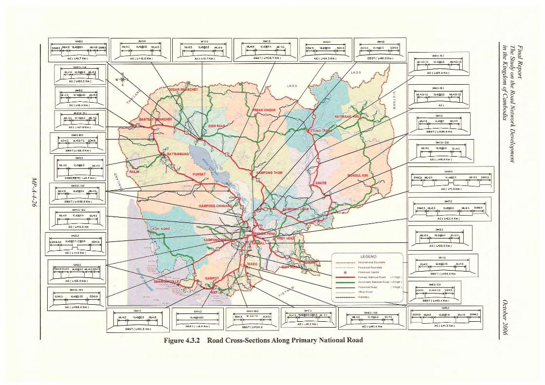
The road cross-sections of primary national road, including the on-going and committed projects are presented in Figure 4.3.2.
(2) 2-Digit National Roads
The inventory data for the 2-Digit national roads are based on the LRCS Inventory data and the as-built and design drawings collected by the Study Team. Table 4.3.4 presents the road width and pavement types of these roads.
Table 4.3.4 Summary of 2-Digit National Road Inventory
Road Length by Road Width (km) Road
Classification
Pavement
Type w<4.5m 4.5mOw<6.5m 6.5mOw<9.0m w≥9.0m
Total Length
(km)
Concrete - 8.7 - 2.4 11.1
Asphalt - - 1.3 5.2 6.5
DBST 7.8 132.6 324.6 43.0 508.0
Laterite 99.0 948.0 448.0 170.5 1,665.5
Earth 395.9 53.9 2.2 - 452.0
2-Digit
National Road
Total (km) 502.7 1,143.2 776.1 221.1 2,643.1
As presented in the Table 4.3.4, only 19.9% of the 2-Digit national roads are paved with the remaining sections either with laterite or earth road structure. Moreover, 62.3% of the roads are still less than 6.5m wide with only 8.4% of the roads greater than 9.0m wide.
The road width and pavement type distribution for the 2-Digit national road is shown in Figure 4.3.3.

Final Report The Study on the Road Network Development in the Kingdom of Cambodia October 2006
MP-A-4-28
43.3%
29.4%
8.4% 19.0%
w < 4.5m (502.7km)
4.5m ≤ w < 6.5m (1,143.2km)
6.5m ≤ w < 9.0m (776.1km)
w ≥ 9.0m (221.1km)
0100200300400500
DBST Laterite Earth
0100200300400500600700800900
1,000
Concrete DBST Laterite Earth0
100
200
300
400
500
Asphalt DBST Laterite Earth
0
50
100
150
200
Concrete Asphalt DBST Laterite Earth
Figure 4.3.3 Road Width and Pavement Type Distribution for 2-Digit National Roads
(3) Provincial Roads
Similarly, the inventory data for the provincial roads are based on the LRCS Inventory data. Table 4.3.5 presents the road width and pavement types of these roads.
Table 4.3.5 Summary of Provincial Road Inventory
Road Length by Road Width (km) Road
Classification
Pavement
Type w<4.5m 4.5mOw<6.5m 6.5mOw<9.0m w≥9.0m
Total
Length (km)
Concrete - 5.3 - - 5.3
Asphalt - 2.0 1.4 - 3.4
DBST 9.6 62.8 27.3 1.2 100.9
Laterite 564.3 2,645.8 849.5 9.0 4,068.6
Earth 1,611.8 723.0 102.0 0.0 2,436.8
Provincial Road
(3 & 4 – Digit)
Total (km) 2,185.7 3,438.9 980.2 10.2 6,615.0
As presented in the Table 4.3.5, only 1.7% of the 2-Digit national roads are paved with the remaining sections either with laterite or earth road structure. Moreover, 85% of the roads are still less than 6.5m wide with only 15% of the roads greater than 6.5m wide.
The road width and pavement type distribution for the provincial road is shown in Figure 4.3.4.

Final Report The Study on the Road Network Development in the Kingdom of Cambodia October 2006
MP-A-4-29
Figure 4.3.4 Road Width and Pavement Type Distribution for Provincial Roads
4.3.3 Road Network Condition The condition of the road network, as reported by LRCS is shown in Figure 4.3.5 for the national and provincial roads. The primary national road condition, as shown, varies from good to very poor but is expected to change from good to fair following completion of on-going and committed projects. However, although some secondary national roads have either been rehabilitated or is undergoing rehabilitation, a large percentage of the road (about 60%) still have poor to very poor condition. Much more for the provincial roads, where more than 90% of the network’s conditions are poor to very poor.
Figure 4.3.5 Relative Condition of Road Network
0%10%20%30%40%50%60%70%80%90%
100%
1 2 3
Road Classification
% in
Con
ditio
n B
and
Good Fair Poor Very Poor
Primary National Road
Secondary National Road
Provincial Road
Source: LRCS Final Report, November 2004
52.0%
33.0%
0.2%
14.8%
4.5m ≤ w < 6.5m (3,438.9km)
6.5m ≤ w < 9.0m (980.2km)
w < 4.5m (2,185.7km)
w ≥ 9.0m (10.2km)
0
500
1,000
1,500
2,000
DBST Laterite Earth0
500
1,000
1,500
2,000
2,500
3,000
Concrete Asphalt DBST Laterite Earth
0200400600800
1,000
Asphalt DBST Laterite Earth
05
10
DBST Laterite

Final Report The Study on the Road Network Development in the Kingdom of Cambodia October 2006
MP-A-4-30
Photo 4.3.1 Typical Road Condition
NR.3
NR.7
NR.6 NR.5
NR.64
NR.1 NR.2
NR.4
NR.33 NR.48
NR.57 NR.62 NR.76
NR.78 PR.308

Final Report The Study on the Road Network Development in the Kingdom of Cambodia October 2006
MP-A-4-31
4.3.4 Bridge Condition
A review of the data from LRCS 2004 inventory was conducted to determine the existing bridges along Cambodia road network. This inventory was supplemented by the Study Inventory of bridge and culverts along national road NR.5, NR.66, NR.76 and PR.216.
This section covers only bridges included in the LRCS Inventory, and since no data exist for bridges on rural roads MRD bridges will not be discussed herein.
The following definitions were used in this report: • Bridges. Bridges are defined herein as structures crossing waterways or obstructions with
aggregate opening greater than 6.0m, other structures with less than 6.0m opening are considered as culverts.
• Temporary Bridges. Temporary bridges are bridge structures classified as bailey bridges, timber bridges and other structures without complete bridge structural elements and usually with load limit posting of less than 20 tons.
• Permanent Bridges. Permanent bridges are defined as structures other than temporary bridges, either with concrete or steel as the basic structural component of the superstructure and with complete bridge structural elements including abutments. Permanent bridges have the structural capacity to carry the live loading required by the Cambodian Bridge Design Standard. In the inventory, permanent bridges are further divided into bridges with narrow carriageway width (<7m) and bridges with width greater than 7m. Narrow bridges will require improvement measures to satisfy Cambodian Bridge Design requirements.
The summary of the results for bridge inventory and bridge condition along 1-Digit national road are presented in Table 4.3.6 and Table 4.3.7.
In Table 4.3.6 it is seen that about 26 bridges (with a total length of 608m) or 4.6% of the total bridge locations are still considered as temporary bridges of bailey bridge type. These temporary bridges are found in NR.2, NR.3 and NR.7. Such temporary bridges will have to be upgraded to permanent bridges with sufficient structural capacity.
Moreover, 31 bridges or 5.5% of the permanent bridges have carriageway less than 7.0m wide causing these bridges to be the bottlenecks among the 1-Digit national roads. Narrow bridges exist in NR.2, NR.3, NR.5, NR.6, and NR.7. These bridges will have to be widened to that required by the standard for the road sections. However, only 334 bridges (59.3% of permanent bridges) have carriageway widths greater than 10m where shoulders functioning as motorbike lanes are provided.
As seen in the table, concrete bridges (93%) are preferred over steel bridges for permanent bridges along 1-Digit national roads.
Final Report The Study on the Road Network Development in the Kingdom of Cambodia October 2006
MP-A-4-32
Table 4.3.6 Bridge Inventory Along 1-Digit National Road (Including On-going Projects)*
Permanent Bridges - No. (Length, m)
Narrow Bridges (w < 7m)*** Wider Bridges (w > 7m) Road No.
Temporary Bridges***
No. (Length, m) Type
w<4.5m 4.5m≤w<7m Total 7m≤w<10m w≥10.0m Total
Concrete - - - 1 (149.6) 19 (919.9) 20 (1,069.5) NR.1 -
Steel - - - - 3 (90.8) 3 (90.8)
Concrete - 3 (19.0) 3 (19.0) 10 (158.5) 5 (214.9) 15 (373.4) NR.2
14 (232.8) Steel - - - 1 (8.0) - 1 (8.0)
Concrete - 15 (169.9) 15 (169.9) 21 (507.8) 24 (642.6) 45 (1,150.4) NR.3
11 (245.3) Steel - 2 (65.0) 2 (65.0) 1 (290.0) - 1 (290.0)
Concrete - - - 39 (1,064.5) 1 (8.2) 40 (1,072.7) NR.4 -
Steel - - - - - -
Concrete - 7 (238.1) 7 (238.1) 53 (616.3) 83 (1,423.3) 136 (2,039.6)NR.5 -
Steel - 1 (45.3) 1 (45.3) 25 (873.4) - 25 (873.4)
Concrete - 2 (54.9) 2 (54.9) 39 (1,213.8) 130 (2,909.6) 169 (4,123.4)NR.6 -
Steel - - - 5 (338.5) 2 (816.9) 7 (1,155.4)
Concrete - 1 (10.0) 1 (10.0) 3 (1,075.0) 67 (3,111.4) 70 (4,186.4) NR.7
1 (130.0) Steel - - - - - -
Concrete - 28 (491.9) 28 (491.9) 166 (4,785.5) 329 (9,229.9) 495 (14,015.4)
Steel - 3 (110.3) 3 (110.3) 32 (1,509.9) 5 (907.7) 37 (2,417.6) Total 26
(608.1)
Total - 31 (602.2) 31 (602.2) 198 (6,295.4) 334 (10,137.6)
532 (16,433.0)
*On-going bridge projects are included in the inventory as permanent bridges
**Source: Study Team 2005 Inventory (NR.5 & NR.6) and Collected as-built and design drawings
***In the Master Plan under this Study, temporary bridges and narrow bridges will be improved to satisfy Cambodian bridge standard.
Total number and length of 1-Digit bridges for improvement = 57 bridges (1,210m)
Table 4.3.7 Permanent Bridge Condition Along 1-Digit National Road
Bridge Condition - No. (Length, m) Road No.
Good Fair Poor
NR.1 23 (1,160.3) - -
NR.2 14 (362.0) 5 (38.4) -
NR.3 30 (1,317.4) 33 (357.9) -
NR.4 40 (1,072.7) - -
NR.5 158 (3,028.3) 11 (168.2) -
NR.6 153 (4,539.2) 25 (794.5) -
NR.7 71 (4,196.4) - -
Total 489 (15,676.3) 74 (1,359.0) - Source: Study Team Inventory (NR.5 and NR.6), 2005 and LRCS Inventory, 2004 *On-going bridge projects are grouped into “Good” condition **No improvement measure is necessary for 1-Digit bridges, only maintenance work shall be carried-out.

Final Report The Study on the Road Network Development in the Kingdom of Cambodia October 2006
MP-A-4-33
The conditions of the permanent bridges are presented in Table 4.3.7. It is seen that 86.9% of the permanent bridges along 1-Digit national roads are in good condition with 13.1% in fair condition and requiring minor repair and maintenance.
The 2-Digit national road and provincial road bridge inventory and bridge conditions are summarized in Table 4.3.8 and Table 4.3.9, respectively.
As presented in Table 4.3.8, there are no bridges on 107 rivers/waterways (with a total length of 1,901m) along the 2-Digit national roads. Moreover, temporary bridges are identified at 392 locations (with total bridge length of 7,392m). Permanent bridges will need to be constructed at these sites during the improvement of the 2-Digit national roads.
At least 17 historical bridges (laterite stone bridges with a total length of 364.8m) are found to exist along 2-Digit national roads. These bridges, with historical significance, are not designed for the requirements of the present live load and will require construction of new bridges. Such historic bridges may need preservation and may require road realignment for new bridge construction.
Among the permanent bridges, 139 bridges (with length of 2,126.7m) have narrow carriageway width of less than 7m. Widening of these bridges is necessary to the required road functional class.
Table 4.3.8 Bridge Inventory Along 2-Digit National Road and Provincial Road
Permanent Bridges - No. (Length, m)
Narrow Bridges (w < 7m)*** Wider Bridges (w > 7m) Road Class
Temporary Bridges***
No. (m)
Historical Bridges***
No. (m)
No ExistingBridges***
No. (m) Type
w<4.5m 4.5m≤w<7m Total 7m≤w<10m w≥10.0m Total
Concrete 37 (366.4) 74 (872.5) 111 (1,238.9) 65 (2,816.9) 56 (2,749.8) 121
(5,566.7) 2-Digit National
392 (7,392)
17 (364.8)
107 (1,901)
Steel 9 (168.0) 19 (719.8) 28 (887.8) 6 (161.9) - 6 (161.9)
Concrete 106 (1,989.0)
117 (1,608.6)
223 (3,597.6) 7 (82.0) 3 (70.4) 10 (152.4) 3-Digit
Prov’l 313
(5,956) -
3 (165)
Steel 30 (723.0) 9 (289.0) 39 (1,012.0) 1 (30.0) - 1 (30.0)
Concrete 135 (1,790.7) 88 (1,291.1) 223
(3,081.8) 1 (43.0) 1 (30.0) 2 (73.0) 4-Digit Prov’l
305 (5,824)
- -
Steel 10 (260.0) 4 (85.0) 14 (345.0) - - -
Concrete 278 (4,146.1)
279 (3,772.2)
557 (7,918.3) 73 (2,941.9) 60 (2,850.2) 133
(5,792.1)
Steel 49 (1,151.0) 32 (1,093.8) 81 (2,244.8) 7 (191.9) - 7 (344.3) Total 1010
(19,172) 17
(364.8) 110
(1,966)
Total 327 (5,297.1)
311 (4,866.0)
638 (10,163.1) 80 (3,133.8) 60 (2,850.2) 140 (6,136.)
*On-going bridge projects are included in the inventory as permanent bridges
**Source: LRCS 2004 Inventory and Study Team 2005 Inventory
***Temporary bridges, historical bridges, narrow bridges and waterways without bridges will require improvement measures to satisfy Cambodian bridge standard. However, in this Study, the master plan covers only the improvement of 2-Digit roads and some 3-Digit roads in support of the development objectives and the road network completion. Routine maintenance shall be done on bridges not included for improvement. Total for 2-Digit road bridge improvement = 655 bridges (11,785m). Total for 3-Digit road bridge improvement included in master plan = 207 bridges (4,372m).

Final Report The Study on the Road Network Development in the Kingdom of Cambodia October 2006
MP-A-4-34
However, in Table 4.3.9, 59 bridges (total length of 710.5m) along 2-Digit national roads are found to be in poor condition necessitating major repairs while 66 bridges (length of 941m) are in fair condition requiring minor repairs and maintenance. Based on the LRCS inventory, there no bridges on at least 3 river/waterway locations (with a length of 165m) while 618 bridges (11,780m long) are identified to be temporary. Provincial roads are found to have both concrete and steel bridges with about 97.5% having narrow carriageway (width < 7m), see Table 4.3.8.
Moreover, among the permanent bridges along provincial roads, 22.3% (114bridge) are in fair condition requiring minor repairs and maintenance. However, 64 bridges are in poor condition requiring major repairs. At least 10 bridges along the provincial roads collapsed rendering them impassable.
Table 4.3.9 Bridge Conditions along 2-Digit National Roads and Provincial Roads
Bridge Condition - No. (Length, m) Road Class
Good Fair Poor Collapsed
No. (Length, m) Total
No. (Length, m)
2-Digit National Road 141 (6,203.0) 66 (941.0) 59 (710.5)* - 266 (7,854.5)
3-Digit Provincial Road 166 (3,398.0) 55 (758.2) 46 (556.2)** 6 (79.6) 273 (4,792.0)
4-Digit Provincial Road 158 (2,688.7) 59 (617.7) 18 (160.4) 4 (33.0) 239 (3,499.8)
Total 465 (12,289.7) 180 (2,316.9) 123 (1,427.1) 10 (112.6) 778 (16,146.3)
Source: LRCS Inventory, 2004
*Bridges with poor conditions in 2-Digit roads are those basically old bridges with narrow carriageway width and are included for bridge improvement in the Study Master Plan.
**Poor condition bridges in 3-Digit roads which are part of the road network improvement Master Plan are included for bridge improvement. Other bridges in 3-Digit and 4-Digit roads not included in the Master Plan are included for maintenance works.
4.3.5 Supplementary Road Inventory Survey
(1) Scope of Work for Supplementary Road Inventory Survey
The Study Team conducted a supplementary road inventory survey by employing a local survey consultant, with the following two survey scopes:
- To carry out the road inventory survey on NR.66, PR.216 and NR.76. - To carry out the bridge and box culvert inventory survey on NR.5.
Locations of the above surveys are shown in Figure 4.3.6.
1) Road Inventory Survey on NR.66, PR.216 and NR.76
The Location and Reference and Condition Survey (hereafter refer to as LRCS) was conducted as one of components of the Road Rehabilitation Project under World Bank Credit No.3181-KH. LRCS aims to collect basic planning data on the national and provincial road network, to create

Final Report The Study on the Road Network Development in the Kingdom of Cambodia October 2006
MP-A-4-35
the Road Database of MPWT, and to ensure that the GIS database will facilitate the utilization of HDM-4 and RED models which in turn will provide the basis for a decision support system with which to manage the road network of Cambodia. The main output form the study of LRCS is the creation of the database containing information on the 10,000 km of the national and provincial road.
Figure 4.3.6 Location of Supplementary Road Inventory Survey
LRCS was completed on October 2004, however, the surveys of the following national and provincial roads were not included in survey scopes of total length 10,000 km:
2-Digit national road : NR.66 and NR.76 (total length: 221 km) 3-Digit provincial road : PR.101, PR.112, PR.124, PR.132, PR.145, PR.146, PR.148
PR.202, PR.216 PR.301, PR.305, PR.308, PR.315, PR.320, PR.321, PR.323, PR.328, PR.334, PR.339, PR.343, PR.345 (total length: 376 km)
Among the above un-surveyed roads, the three roads as shown in Table 4.3.10 were surveyed as
NR-5Bridge and Box Culvert
Inventory Survey( PK 5 - PK357 )
NR-66Road Inventory Survey
L = 76 km(Sta.64 - Sta.139.9 )
PR-216Road Inventory Survey
L = 132 km
NR-76Road Inventory Survey
L = 145 km
Final Report The Study on the Road Network Development in the Kingdom of Cambodia October 2006
MP-A-4-36
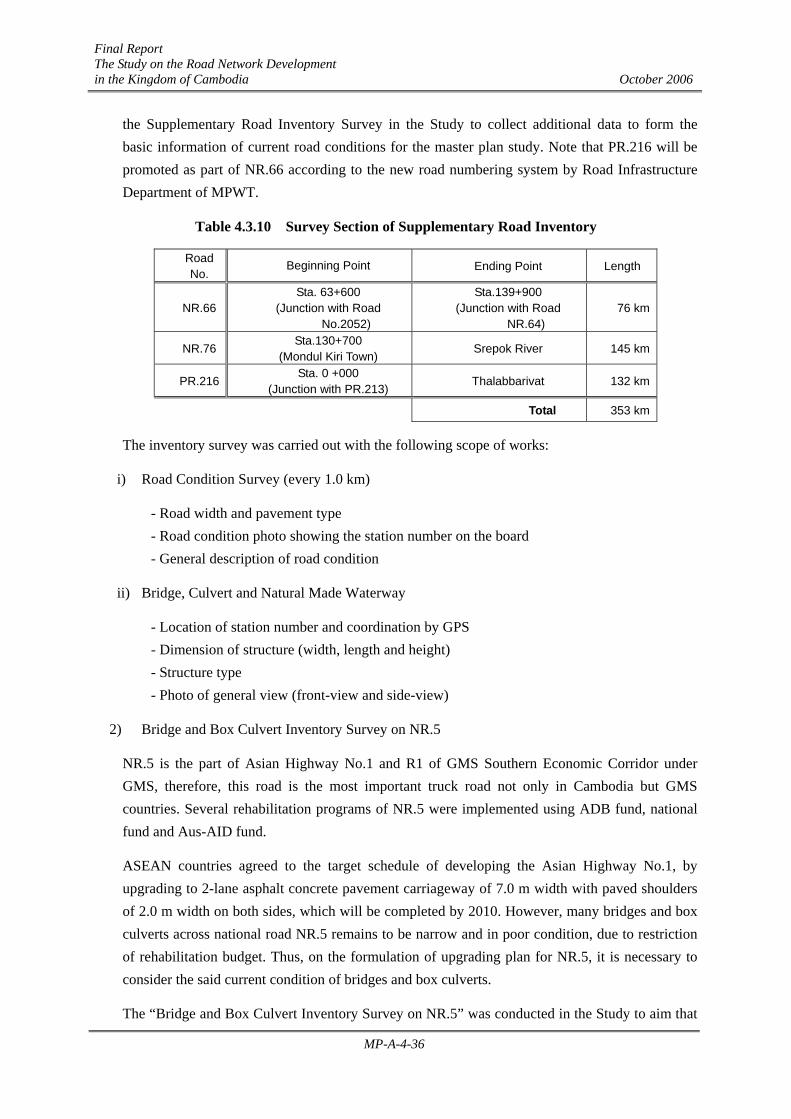
the Supplementary Road Inventory Survey in the Study to collect additional data to form the basic information of current road conditions for the master plan study. Note that PR.216 will be promoted as part of NR.66 according to the new road numbering system by Road Infrastructure Department of MPWT.
Table 4.3.10 Survey Section of Supplementary Road Inventory
Road No.
Beginning Point Ending Point Length
NR.66 Sta. 63+600
(Junction with Road No.2052)
Sta.139+900 (Junction with Road
NR.64) 76 km
NR.76 Sta.130+700
(Mondul Kiri Town) Srepok River 145 km
PR.216 Sta. 0 +000
(Junction with PR.213) Thalabbarivat 132 km
Total 353 km
The inventory survey was carried out with the following scope of works:
i) Road Condition Survey (every 1.0 km)
- Road width and pavement type - Road condition photo showing the station number on the board - General description of road condition
ii) Bridge, Culvert and Natural Made Waterway
- Location of station number and coordination by GPS - Dimension of structure (width, length and height) - Structure type - Photo of general view (front-view and side-view)
2) Bridge and Box Culvert Inventory Survey on NR.5
NR.5 is the part of Asian Highway No.1 and R1 of GMS Southern Economic Corridor under GMS, therefore, this road is the most important truck road not only in Cambodia but GMS countries. Several rehabilitation programs of NR.5 were implemented using ADB fund, national fund and Aus-AID fund.
ASEAN countries agreed to the target schedule of developing the Asian Highway No.1, by upgrading to 2-lane asphalt concrete pavement carriageway of 7.0 m width with paved shoulders of 2.0 m width on both sides, which will be completed by 2010. However, many bridges and box culverts across national road NR.5 remains to be narrow and in poor condition, due to restriction of rehabilitation budget. Thus, on the formulation of upgrading plan for NR.5, it is necessary to consider the said current condition of bridges and box culverts.
The “Bridge and Box Culvert Inventory Survey on NR.5” was conducted in the Study to aim that
Final Report The Study on the Road Network Development in the Kingdom of Cambodia October 2006
MP-A-4-37
the information of existing condition for the bridge and box culvert is collected to reflect on formulating the future development plan of NR.5. The scope of works for the survey is as follows:
- To conduct the site survey for all of the existing bridges and box culverts on NR.5 between Phnom Penh and Sisopon section (from PK 5 to PK357)
- The results of site survey for bridges and box culverts are summarize by using the inventory sheets as shown in Table 4.3.11
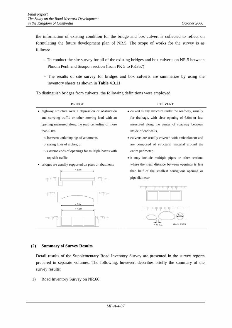
To distinguish bridges from culverts, the following definitions were employed:
BRIDGE CULVERT
• highway structure over a depression or obstruction
and carrying traffic or other moving load with an
opening measured along the road centerline of more
than 6.0m
o between undercopings of abutments
o spring lines of arches, or
o extreme ends of openings for multiple boxes with
top slab traffic
• bridges are usually supported on piers or abutments
• culvert is any structure under the roadway, usually
for drainage, with clear opening of 6.0m or less
measured along the center of roadway between
inside of end walls,
• culverts are usually covered with embankment and
are composed of structural material around the
entire perimeter,
• it may include multiple pipes or other sections
where the clear distance between openings is less
than half of the smallest contiguous opening or
pipe diameter
(2) Summary of Survey Results
Detail results of the Supplementary Road Inventory Survey are presented in the survey reports prepared in separate volumes. The following, however, describes briefly the summary of the survey results:
1) Road Inventory Survey on NR.66
> 6.0m
> 6.0m
> 6.0m
< ½ dmin
dmin
dmin ≥ 1.52m

Final Report The Study on the Road Network Development in the Kingdom of Cambodia October 2006
MP-A-4-38
NR.66 had been an important road from the old times of Angkor Wat Era, however, ruin of road condition is remarkable due to the dreadful influence of civil war in Cambodia. Several historical stone bridges, which may be supposed to be built in Angkor Wat Era, are remaining.
Table 4.3.11 Sample of Inventory Sheet for Bridges and Box Culvert on NR.5
Location Type / Materials / ConditionPK 000 + 0000 Superstructure / / Good (01/05/2005)
Province : Pier / / Fair (01/05/2005)District : Abutment / / Poor (01/05/2005)
Specification Fundation Pier / / (01/05/2005)
Length : m Abutment / / (01/05/2005)Span: Slab / good (01/05/2005) 2002
Width : m Surface / (01/05/2005)Regulations Obstacles Deck Elevation: El + m Max. Flood Level : m (Year: 2000)
ton Photo (Front of View)mm
Cross Setion
Photo (Side of View)
Remarks
Route No. Structure No.
40.02
12.0Construction Year :
Repaired Year :
Affixed Article/Utilities:Weight Limit :Width Limit :Height Limit :
25--
Asphalt(t = 5.0 cm)
2.50 2.502 @ 3.50 = 7.00
12.00 1.000.25
RC Concrete Slab(t = 20.0 cm)
1.00 0.25
For Bridge
Deck E levation: El
+ m
Max. Flood Level
Max. Flood
Height From
Deck, H
NOTE: Indicate river, bank and abutment protection condition if there is a need to extend bridge (by
how many meters) or if bridge length is sufficient.
1
2
3
4
5
Flood Data: Road Elevation: Max. Flood Level: m
Location Culvert Submerged During Flood? Yes No (Year: )PK 000 + 0000 Cross Section Remarks
Province :District :
SpecificationLength : m
Dimension :Width : m
Regulationston
Usage
Conditon
Construction Year
Repaired Year
Photo (Front of View) Photo (Side of View)
m
3-2.0 m x 1.5 m
(01/05/2005)
5.0
Weight Limit :
Route No. Structure No.
10.0
25
For Box Culvert
NOTE: Indicate river/stream and
culvert opening condition if there is a need to increase number of culvert cells or replace the culvert by bridge.
1
2
3
4
MFWLMFWL

Final Report The Study on the Road Network Development in the Kingdom of Cambodia October 2006
MP-A-4-39
This road runs through the forest where trees are growing in abundance in some parts of the road section while laterite pavement has been washed out. Consequentially, the conditions of the road are very narrow and poor. In the field inventory survey, 26 locations of pipe culvert, 20 locations of bridge structure and 20 location of natural waterway cutting road, that will require construction of bridge or culvert structure on the rehabilitation of NR.66, were confirmed as shown in Table 4.3.12.
2) Road Inventory Survey on PR.216
PR.216 will be upgraded to 2-Digit national road and will become part of NR.66. However, the road conditions are verified to be very poor. The road surface is natural earth without laterite covering material and neither bridge nor culvert structure exists at the river and natural waterway within PR.216 road. 45 locations of natural waterway were confirmed in the survey.
3) Road Inventory Survey on NR.76
NR.76 runs between Snoul on NR.7 of Kratie Province and O Cheng on NR.78 of Ratana Kiri Province passing Saen Monourom of Mondol Kiri Province with total length of 335 km.
The section between Snoul and Saen Monourom had been rehabilitated with laterite pavement of 7 m width by the army engineering using national fund. The current survey section is extremely poor. According to the hearing from residents along the road, some of village inhabitant use elephant as a mode of transportation during the rainy season. However, the rehabilitation work on the section between Saen Monourom and Kaoh Nheaek is being implemented by the army engineering to promote regional development for the remote area of Mondul Kiri Province and strengthen tourism demand between Mondul Kiri and Ratanak Kiri Province.
Table 4.3.12 Summary of Structures and Natural Waterways on NR.66, PR.216 and NR.76
Pipe Culvert Bridge Natural Waterway Survey
Route No. of Location No. of Location Length (m) No. of Location Length (m)
NR.66 26 20 401.2 20 531.3
PR.216 - - - 45 535.0
NR.76 57 13 180.9 28 537.7
4) Bridge and Box Culvert Inventory Survey on NR.5
On ADB Loan No.1697-CAM(SF), Primary Roads Restoration Project, the screening for the selection of rehabilitation of bridges and culverts located between Phnom Penh and Sisophon was conducted at the design stage. The rehabilitated bridge and culvert are designed to ensure 10 m width (7.0m of 2-lane carriageway with 1.5 m of hard shoulder on both sides). However, the results of the inventory survey, confirmed that the structures at 57 locations (with a total length of 366.7 m) are less than 5.0 m wide and the structures of 108 locations (with a total length of 1,472.8 m) are less than 10.0 m wide as shown in Table 4.3.13.

Final Report The Study on the Road Network Development in the Kingdom of Cambodia October 2006
MP-A-4-40
Table 4.3.13 Summary of Road Cross Structure on NR.5 (Phnom Penh – Sisophon Section)
Roadway Width of Structure
Less than 7.0 m 7.0 m to 10.0 m More than 10.0 m Structure
No. Length (m) No. Length (m) No. Length (m)
Bridge 10 335.3 34 1,084.3 54 1043.1
Box Culvert 7 31.4 75 399.7 44 386.0
Photo 4.3.2 Typical Bridges Along National and Provincial Roads
Steel Girder + Truss (NR.5) Concrete Bridge (NR.6)
Historical Laterite Bridge (NR.6)
Collapsed Concrete Truss Bridge (NR.6)
Kizuna Bridge (PC Box)(NR.7)
Bailey Bridge (NR.11)
Collapsed Bailey Bridge (NR.33)
Concrete Truss Bridge (NR.31)
Timber Bridge under Repair (NR.78)
Final Report The Study on the Road Network Development in the Kingdom of Cambodia October 2006
MP-A-4-41
4.4 Review of Past Flood and Damages
4.4.1 Mekong River Flood
(1) The Mekong River
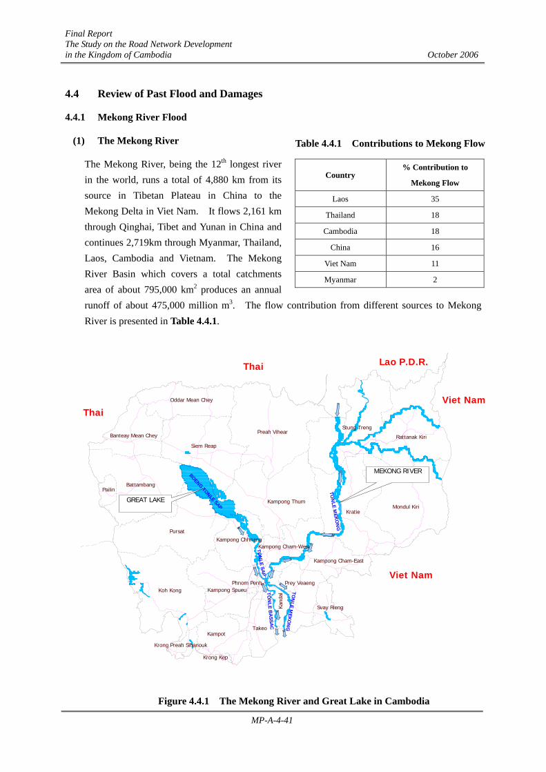
The Mekong River, being the 12th longest river in the world, runs a total of 4,880 km from its source in Tibetan Plateau in China to the Mekong Delta in Viet Nam. It flows 2,161 km through Qinghai, Tibet and Yunan in China and continues 2,719km through Myanmar, Thailand, Laos, Cambodia and Vietnam. The Mekong River Basin which covers a total catchments area of about 795,000 km2 produces an annual runoff of about 475,000 million m3. The flow contribution from different sources to Mekong River is presented in Table 4.4.1.
Figure 4.4.1 The Mekong River and Great Lake in Cambodia
Pursat
Battambang
Kampot
Krong Preah Sihanouk
Koh Kong
Kampong Thum
Siem Reap
Preah Vihear
Kratie
Viet Nam
Viet Nam
Thai
Lao P.D.R.
Mondul Kiri
Oddar Mean Chey
Kand
al
Phnom Penh
Takeo
Kampong Spueu
Kampong ChhnangKampong Cham-West
Kampong Cham-East
Prey Veaeng
Svay Rieng
Banteay Mean Chey Rattanak Kiri
Pailin
Thai
Krong Kep
Stung Treng
BOENG TONLE SAP
TON
LE SAP
TON
LE MEK
ON
G
TON
LE BA
SSAC
TON
LE MEK
ON
G
MEKONG RIVER
GREAT LAKE
Table 4.4.1 Contributions to Mekong Flow
Country % Contribution to
Mekong Flow
Laos 35
Thailand 18
Cambodia 18
China 16
Viet Nam 11
Myanmar 2

Final Report The Study on the Road Network Development in the Kingdom of Cambodia October 2006
MP-A-4-42
In Cambodia, Mekong Rivers flows 486 km from the border in the north with Laos to the Viet Nam
border in the south. Cambodia, being located in the lower Mekong Basin, has basically two major
wetland regions – the Mekong River and its flood plain and the Great Lake and Tonal Sap
floodplain.
(2) The Great Lake and Mekong River Flood Pattern
The Great Lake, Tonle Sap River and the Mekong River systems exhibit a unique seasonal hydrologic pattern. During the period from October to May (the period from March to May is considered the dry season), the Great Lake drains through the Tonle Sap River and the flow combination with the Upper Mekong River bifurcates into the Lower Mekong and the Bassac Rivers. This is the falling stage, when the water level falls during a decreasing flood and discharges downstream to Vietnam. However, at the start of the monsoon from June to September, the Tonle Sap River reverses its flow when the Upper Mekong River divides its flow into the Lower Mekong, Bassac and Tonle Sap rivers. During this peak flow period in the wet season, the capacity of the Lower Mekong river is inadequate to convey flood waters – rising to approximately 9m of water level at the Mekong/Tonle Sap confluence in Phnom Penh.
The Great Lake, which is considered the largest freshwater lake in Southeast Asia, acts as a natural flood storage reservoir and functions as flood regulator for the southern Cambodia and the Mekong Delta by decreasing peak flows in the wet season and increasing flows in the dry season. As the lake is being filled up during the flood season, its reducing effect in the peak flows is diminished, resulting to higher flood water levels in the downstream of Mekong River from Phnom Penh. At its peak in October, the Great Lake expands to several times its dry season size, flooding its shorelines and large parts of the surrounding areas. The floodwater then gradually recedes between October and February releasing freshwater to the Mekong Delta. This natural flood cycle of the Lower Mekong Basin sustains agricultural and fishery production which is significant to food production of the entire country. On the contrary, severe flooding has become an annual threat to life and property in Cambodia causing significant loss to the country’s infrastructure and the lives of many people.
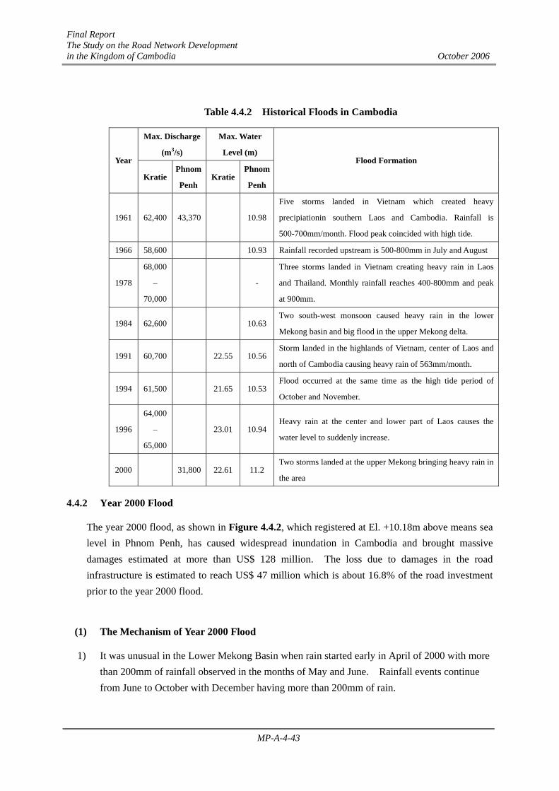
(3) Historical Floods
There are eight major floods (see Table 4.4.2) since 1960 that have resulted in substantial damages in the Mekong Delta. Among these floods, the year 2000 flood has brought serious impact to Cambodia with damages amounting to more than US$128 million.
Final Report The Study on the Road Network Development in the Kingdom of Cambodia October 2006
MP-A-4-43
Table 4.4.2 Historical Floods in Cambodia
Max. Discharge
(m3/s)
Max. Water
Level (m) Year
KratiePhnom
Penh Kratie
Phnom
Penh
Flood Formation
1961 62,400 43,370 10.98
Five storms landed in Vietnam which created heavy
precipiationin southern Laos and Cambodia. Rainfall is
500-700mm/month. Flood peak coincided with high tide.
1966 58,600 10.93 Rainfall recorded upstream is 500-800mm in July and August
1978
68,000
–
70,000
-
Three storms landed in Vietnam creating heavy rain in Laos
and Thailand. Monthly rainfall reaches 400-800mm and peak
at 900mm.
1984 62,600 10.63Two south-west monsoon caused heavy rain in the lower
Mekong basin and big flood in the upper Mekong delta.
1991 60,700 22.55 10.56Storm landed in the highlands of Vietnam, center of Laos and
north of Cambodia causing heavy rain of 563mm/month.
1994 61,500 21.65 10.53Flood occurred at the same time as the high tide period of
October and November.
1996
64,000
–
65,000
23.01 10.94Heavy rain at the center and lower part of Laos causes the
water level to suddenly increase.
2000 31,800 22.61 11.2 Two storms landed at the upper Mekong bringing heavy rain in
the area
4.4.2 Year 2000 Flood
The year 2000 flood, as shown in Figure 4.4.2, which registered at El. +10.18m above means sea level in Phnom Penh, has caused widespread inundation in Cambodia and brought massive damages estimated at more than US$ 128 million. The loss due to damages in the road infrastructure is estimated to reach US$ 47 million which is about 16.8% of the road investment prior to the year 2000 flood.
(1) The Mechanism of Year 2000 Flood
1) It was unusual in the Lower Mekong Basin when rain started early in April of 2000 with more than 200mm of rainfall observed in the months of May and June. Rainfall events continue from June to October with December having more than 200mm of rain.

Final Report The Study on the Road Network Development in the Kingdom of Cambodia October 2006
MP-A-4-44
2) In Cambodia, the average annual rainfall is observed to be 1300mm to 1500mm, with floodwater usually generated from the upper reaches of Mekong River. Discharges in the Mekong River usually start to increase in May or June with its peak occurring in the upper reaches in August or September and in the lower reaches in September or October.
Figure 4.4.2 Year 2000 Flood in Cambodia with Flood Levels at different MOWRAM Stations
3) However, as seen in Figure 4.4.3, water levels at different key stations in Cambodia started to rise in July with levels reaching flood warning stage in mid-July. Although water levels dropped in August at Kratie and Kampong Cham, it remained high in Phnom Penh and Prek Kdam (Tonle Sap River).
4) Since rainfall in 2000 started 2 months earlier and lasting longer than usual, the Great Lake flood storage capacity was filled in July and during the month of September, it can no longer absorb the flood water of the lower Mekong basin, causing the flood water to be absorbed by the flood plain along Mekong, Tonle Sap and Bassac Rivers.
5) Tropical depressions in the months of August and September has brought enormous rainfall in the upper Mekong River section causing large discharge downstream towards Phnom Penh area.
KRATIE EL. +21.53m
STUNG TRENG EL. +48.28m
KAMPONG CHAMEL. +14.98m
NEAK LOEUNGEL. +7.79m
KOH KHELEL. +6.94m
CHAK TOMUKEL. +10.18m
KAMPONG LOUNG EL. +10.63m
PREK KDAMEL. +10.34m
5
5
5
5
5
6
6A
76
6
6
6
7
7
7
1
12
2
3
3
4
4
11
6
Final Report The Study on the Road Network Development in the Kingdom of Cambodia October 2006
MP-A-4-45
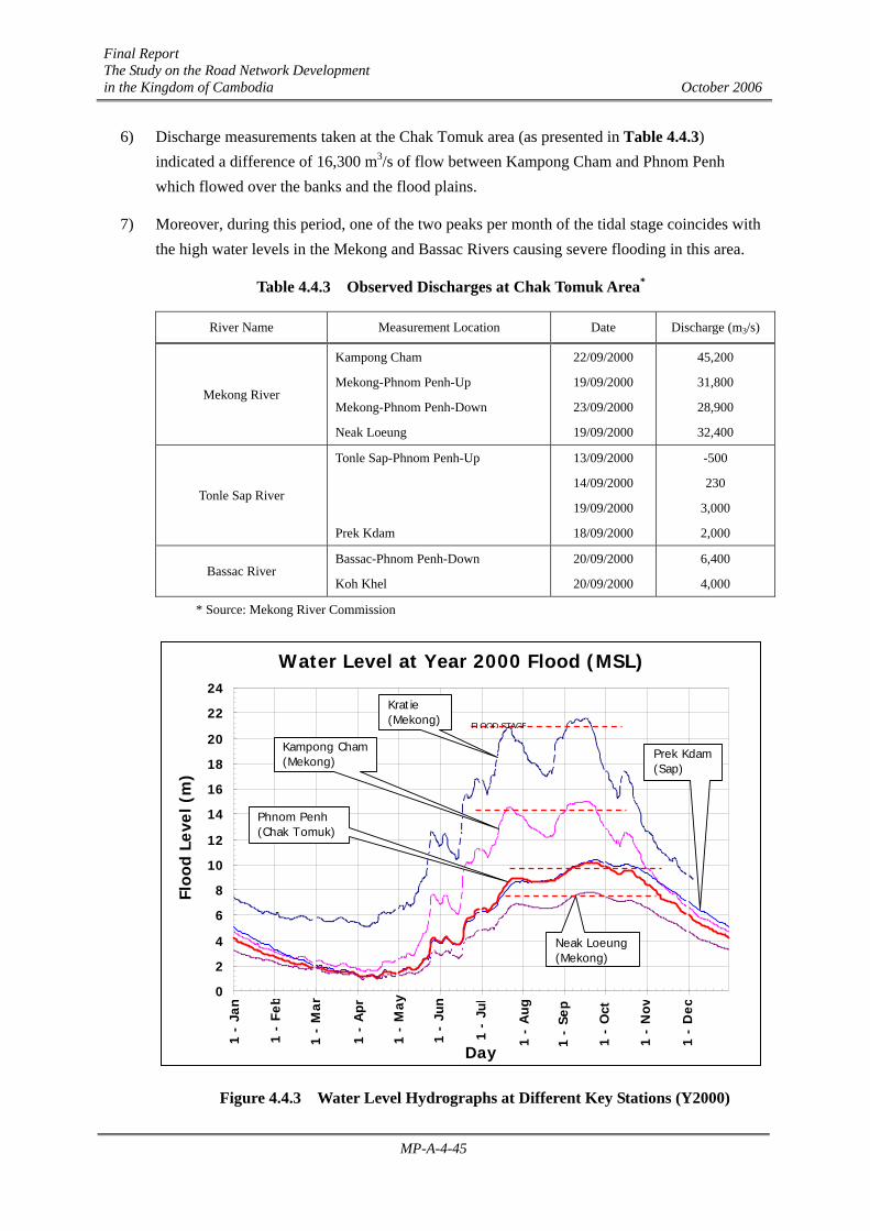
6) Discharge measurements taken at the Chak Tomuk area (as presented in Table 4.4.3) indicated a difference of 16,300 m3/s of flow between Kampong Cham and Phnom Penh which flowed over the banks and the flood plains.
7) Moreover, during this period, one of the two peaks per month of the tidal stage coincides with the high water levels in the Mekong and Bassac Rivers causing severe flooding in this area.
Table 4.4.3 Observed Discharges at Chak Tomuk Area*
River Name Measurement Location Date Discharge (m3/s)
Mekong River
Kampong Cham
Mekong-Phnom Penh-Up
Mekong-Phnom Penh-Down
Neak Loeung
22/09/2000
19/09/2000
23/09/2000
19/09/2000
45,200
31,800
28,900
32,400
Tonle Sap River
Tonle Sap-Phnom Penh-Up
Prek Kdam
13/09/2000
14/09/2000
19/09/2000
18/09/2000
-500
230
3,000
2,000
Bassac River Bassac-Phnom Penh-Down
Koh Khel
20/09/2000
20/09/2000
6,400
4,000
* Source: Mekong River Commission
Figure 4.4.3 Water Level Hydrographs at Different Key Stations (Y2000)
Water Level at Year 2000 Flood (MSL)
0
2
4
6
8
10
12
14
16
18
20
22
24
1 32 63 94 125
156
187
218
249
280
311
342
Day
Floo
d Le
vel (
m)
Kratie(Mekong)
Kampong Cham(Mekong)
Prek Kdam (Sap)
Phnom Penh(Chak Tomuk)
Neak Loeung(Mekong)
1 -
Jan
1 -
Feb
1 -
Mar
1 -
Apr
1 -
May
1 -
Jun
1 -
Jul
1 -
Aug
1 -
Sep
1 -
Oct
1 -
Nov
1 -
Dec
FLOOD STAGE

Final Report The Study on the Road Network Development in the Kingdom of Cambodia October 2006
MP-A-4-46
8) Figure 4.4.4, which compares flood water hydrographs at different year in Phnom Penh (Chak Tomuk Station), illustrates that for the period June to September, the year 2000 flood exhibited the highest water level with the peak occurring on September 21, 2000. This peak flood level (+10.18m above mean sea level) is the highest among the major floods since 1961.
Figure 4.4.4 Water Level Hydrographs at Phnom Penh (Chak Tomuk Station, Y2000)
(2) Flood Damage
The seriousness of the year 2000 flood in Cambodia is manifested by its far-reaching damage and devastation to the different sectors including agriculture, social, education, economic and infrastructure. The twenty one provinces affected by year 2000 flood includes 131 districts, 883 commune and 5,158 villages – most of which were completely under water and became isolated.
In the agricultural sector, almost 6,680 km2 of agricultural land was damaged by flood with 4,216 km2 destroyed amounting to US$66.07 million. Livestock killed during flood amounted to US$0.48 million.
The number of people affected by flood reaches to almost 3.5 million persons with 347 deaths and 873 injuries.
A total of 860 primary schools and 128 high schools were affected by this flood costing to about US$15.20 million of education related damages.
The road infrastructure also suffered during the 2000 flood with damages amounting to US$46.62 million or 16.8% of the total road infrastructure investment prior to year 2000 flood. Many of the
Water Level at Chak Tomuk (Phnom Penh)
0.0
2.0
4.0
6.0
8.0
10.0
12.0
1-J
an
31
-Jan
1-M
ar
31
-Mar
30
-Ap
r
30
-May
29
-Ju
n
29
-Ju
l
28
-Au
g
27
-Sep
27
-Oct
26
-Nov
26
-Dec
Day
Wat
er L
evel
Ele
vati
on
(m
)
1961
1966
1984
1990
1991
1992
1993
1994
1995
1996
1997
1998
1999
2000
2001
2002
2003
2004
Y2000Y1966 Y1996 Y1961
Rising Stage
FLOOD STAGE
Final Report The Study on the Road Network Development in the Kingdom of Cambodia October 2006
MP-A-4-47
roads along Mekong River and the Great Lake were either breached or overtopped by flood water causing disruption in land transportation.
The estimated impact of the year 2000 flood is summarized in Table 4.4.4 below:
Table 4.4.4 Year 2000 Flood Damage
Sector Damage Quantity Cost (US$)
Agricultural
Rice Crops
Other Crops
Livestock Killed
616,749 has (374,107 has destroyed)
51,272 has (47,461 has destroyed)
Buffaloes/Cows : 2,309
Pigs : 1,619
57.55 million
8.52 million
0.48 million
Sub-total 66.55 million
Social
People Affected
People Evacuated
Deaths
Houses Affected
750,618 families (3.449 million people)
84,717 families (0.387 million people)
347 persons died (873 injured)
317,975 damaged (7,068 destroyed)
Educational
Schools
Primary School
High School
Affected 13 provinces
860 schools
128 schools
15.20 million
Road Infrastructure
National Road
Provincial Road
Local Road
Riverbanks
Bridges
1,801.063 km
482.875 km
337.986 km
2.0 km
3,024.6 m
44.934 million
1.688 million
Sub-total 46.622 million
Total Estimated Damages of Year 2000 Flood 128.372 million
Figure 4.4.5 shows the effect of 2000 flood on the road network.
(3) Road Function During Flood
Figure 4.4.5 is a superimposed satellite image of the year 2000 flood in Cambodia showing affected areas and roads that are either overtopped or breached during the flood period. However, it can be seen from the figure that, in general, the national roads function as a dike for the flood plain which acts as a reservoir during the 2000 flood.
Moreover, it was observed during the 2000 flood that these national roads, especially national roads NR.1, NR.5 and NR.6:
1) function as important links (although breached areas needed temporary countermeasures) to province, cities and districts to continuously convey transport of people and goods,

Final Report The Study on the Road Network Development in the Kingdom of Cambodia October 2006
MP-A-4-48
2) became evacuation areas for people and animals during the flood period,
3) provide emergency access during catastrophes like flood, and
4) protect other areas from being seriously damaged by flood by acting as dikes and prevents further flooding.
Figure 4.4.5 Year 2000 Flood Damage Along National Roads
4.4.3 Flood Risk on Major Roads
To assess the impact of future floods with similar magnitude as the year 2000 flood, the Study Team conducted an investigation of the flood condition of major roads affected by the year 2000 flood. The investigation was based on the:
1) Review of the extent and damage of the year 2000 flood along Mekong River, Bassac River and Tonle Sap Lake,
2) Review of the year 2000 flood level along major roads by site interview and observation, and
3) Review of flood rehabilitation and road improvement projects along major roads through as-built plans and design drawings.
The investigation was limited to the above data gathered and does not include detailed hydrologic and hydraulic analysis of flood.
The results of the investigation is translated into flood risk map on major roads (previously
ROAD NO.
BRIDGE/CULVERT DAMAGED (m)
ROAD DAMAGED
(km) RN1 BR 130m 39 RN2 BR 45m 42 RN3 CUL 3 lines 16.5 RN4 - 1 RN5 - 190 RN6 BR 60m 50 RN7 BR 375m 92 RN6A - 10 RN11 BR 792m, CUL 9 lines 63 RN21 - 5 RN32 - 7 RN44 - 5 RN57 - 10 RN67 - 18 RN68 BR 109m 79 RN63 - 14 RN70 BR 261m 10 RN78 BR 100m 198 RN111 - 15 RN137 - 4 RN138 - 1.5 RN139 - 3.5 RN140 - 1.5 RN222 BR 114m, CUL 4 lines 10 OTHER PR
- 20
ROAD INFRASTRUCTURE DAMAGED BY YEAR 2000 FLOOD
TOTAL LENGTH OF DAMAGED ROAD : 2,623.924 km
National Road : 1,801.1 km Provincial Road : 482.9 km
Local Roads : 338.0 km Riverbanks : 2.0 km
TOTAL LENGTH OF DAMAGED BRIDGE :
3,024.6 m
SOURCE: MINISTRY OF PUBLIC WORKS AND TRANSPORT
NOVEMBER 2000
5
5
5 7
6
6
6
6
7
7
7
1 2
2
3
3
4
4
11
61
1
6
6A 5
21
5
FLOOD AREA ALONG THE ROAD
5
5
5
5
5
6
6
6
6
6
6
6A
2
21
11
7
7
7
1
123
3 4
4
BREACHED SECTION OF ROAD

Final Report The Study on the Road Network Development in the Kingdom of Cambodia October 2006
MP-A-4-49
affected by the 2000 flood) is presented in Figure 4.4.6. There are indications that flood level of the same magnitude as the 2000 flood will still be above the road level in some road sections while some road section will have a free board of about 0 – 0.5m below the road. Findings of the investigation include:
• Flood Level 0 – 0.5m Above Road
Road No. Approx. Length (km) Remarks
4 2.00
7 0.90 NR.7 rehabilitation realigns this section 5kms eastward
33 7.36 Section is under ADB project announcement
57 3.00
63 7.84
68 24.00 Section is under ADB project announcement
Note: This map is based on the flood level field survey conducted by the Study Team at limited road sections and indicates possibility of flood occurring on existing roads with a similar scale as the year 2000 flood.
Figure 4.4.6 Flood Risk Along Major Roads

Final Report The Study on the Road Network Development in the Kingdom of Cambodia October 2006
MP-A-4-50
4.5 Mine and UXO Contamination
Cambodia, geographically located in the southeast region of Asia on the Gulf of Thailand, covers about 181,035 square kilometers of land which are mostly forested, mountainous, and inaccessible due to poor infrastructure and landmines together with unexploded ordnance (UXO). The country shares its history with the neighboring countries of Vietnam, Laos and Thailand and has been exposed to several decades of political unrest, tension, colonial and civil wars, and international border conflicts. This has resulted to loss of millions of lives, severe and extensive damages to national economy and infrastructures and the long-term serious threats to life and development brought about by the landmines and UXO which are scattered throughout the country. The poor people, mostly living in rural areas (where about 85% of the total population lives), are the ones most likely to fall victim to such threats thus further aggravating their condition and the countries efforts for development.
This section is referred to the Cambodian Mines Action Center (CMAC) and the Cambodian Mine Action and Victim Assistance Authority (CMAA).
4.5.1 UXO and Landmine History
1) Unexploded Ordnances (UXO)
The unrest in Cambodia started with the World War II, when the country fell victim to international conflicts. During this time, bombs were dropped, exploded ordnances become fragments and scattered everywhere and unexploded ordnances were hidden and ready to explode. After the Second World War came the French Indochina Wars in the 1950s bringing more bombs dropped, grenades thrown and bullets fired.
Perhaps the most damaging war was during the period from 1969 to 1975 when 539,129 tons of air-to-ground bombs were dropped to Cambodia as part of the Vietnam War. This has left a legacy of thousands of unexploded bombs and ammunitions affecting the lives and safety of the Cambodian population to date.
Figure 4.5.1 shows the potential UXO contamination in Cambodia.
2) The Landmines
In 1967, the North Vietnamese army laid the first landmines in Cambodia to protect their bases and supply routes during the Vietnam War period. The United States responded in 1969 to 1973 by dropping tons of bombs and laying mines well within the neutral Cambodia.
In 1970, General Lon Nol staged a coup against Prince Norodom Sihanouk which sparked the war between the Khmer Rouge and the US-backed Lon Nol regime bringing more conflict and landmines to the rest of Cambodia. Both the Khmer Rouge and Lon Nol relied heavily on land mines for military purposes and to beef up defenses.

Final Report The Study on the Road Network Development in the Kingdom of Cambodia October 2006
MP-A-4-51
Figure 4.5.1 Potential UXO Contamination in Cambodia
Figure 4.5.2 Potential Landmine Contamination in Cambodia
Source: CMAC
Source: CMAC

Final Report The Study on the Road Network Development in the Kingdom of Cambodia October 2006
MP-A-4-52
The period of 1975 to 1979 saw extensive use of land mines by the Khmer Rouge (which controls the country during this period) along the borders with Vietnam and Thailand, turning the country into what was called “a prison without walls”. Conflict intensified further in 1978 when Vietnam invaded Cambodia, forcing the Khmer Rouge to flee to the jungles.
After 1979, guerilla warfare continued throughout Cambodia and landmine became the weapon of choice by all parties involved in the conflict to protect their territories, channel enemy forces to vulnerable positions and demoralize communities.
The period of 1985 and 1989 (when the Vietnamese troops withdraw from Cambodia) were seen as the major episode of mine laying in Cambodia. Millions of mines were laid in the 600 kilometer barrier along the Thai border to hold back resistance forces. As an offensive, resistance fighters laid mines deep in the country.
Mines continued to be employed by Khmer Rouge and Government forces even after the 1993 elections. During the three decades of mine laying in Cambodia, it has been the practice to lay much denser minefield than necessary not only in battlegrounds but also in civilian communities. And since landmine maps were not generally drawn, locating and clearing these mines became a complicated and difficult task.
Figure 4.5.2 shows the potential areas of landmine contamination in Cambodia.
4.5.2 Landmine and UXO Problems
1) Contamination
The three decades of conflict in Cambodia has made it one of the most heavily landmine/UXO-contaminated countries in the world. It is estimated, as per Landmine Impact Survey of 2002, that there are 3,075 areas (equivalent to 4,466 square kilometers) suspected of being contaminated by landmines, unexploded ordnance and cluster bombs, see Figure 4.5.1 and 4.5.2.
The areas suspected covers about 46.2% of all Cambodian villages (6,421 villages) with 23.7% of these villages very severely impacted, 24.2% impacted severely and 52.1% less severely. Among the suspected areas, 61% are concentrated in five provinces of Battambang, Banteay Meanchey, Oddar Meanchey, Preah Vihear and Pailing municipality. The survey further indicates that 5.18 million Cambodians are at risk due to the presence of landmines and UXO.
It is observed that:
(1) northern provinces along Thailand and Cambodian border are more heavily mined areas than other parts of Cambodia, and
(2) provinces along the Vietnamese and Cambodian border are more affected by Unexploded Ordnance (UXO) than other parts of Cambodia.

Final Report The Study on the Road Network Development in the Kingdom of Cambodia October 2006
MP-A-4-53
Moreover, mine contamination has a great socio-economic impact on the life of the rural population and has restricted access to different areas as presented in Table 4.5.1.
Table 4.5.1 Mine Impact by Type (Level 1 Survey)
Description No. of Areas %Area % Area
Surface
Area Surface (km2)
Impact
Restricted Access to Homes 792 26.8 58.7 2,621.54 32,904 house
Restricted Access to Home Construction Land 590 20.0 50.9 2,273.19 16,168 houses
Restricted Access to Agricultural Land 2077 70.4 84.6 3,778.24 102,778 families
Restricted Access to Pasture Land 1781 60.4 72.5 3,237.85 105,707 families
Restricted Access to Water Sources 1184 40.1 64.5 2,880.57 84,558 families
Restricted Access to Forest 2000 67.8 91.1 4,068.53 172,878 families
Restricted Access to School 525 17.8 46.9 2,094.55 44,079 students
Restricted Access to Dams, Canals 335 11.3 15.2 678.83 1,031 villages
Restricted Access to Markets 439 14.9 41.0 1,831.06 1,334 villages
Restricted Access to Business Activities 353 11.9 37.0 1,652.42 596 villages
Restricted Access to Health Center 455 15.4 41.5 1,853.39 1,312 villages
Restricted Access to Pagoda 527 17.8 44.9 2,005.23 1,487 villages
Restricted Access to Bridge 136 4.6 14.8 660.97 242 villages
Restricted Access to Neighboring Village 896 30.4 55.8 2,492.03 2,272 villages
2) Casualties
After more than a decade of peace in Cambodia, an average of 70 civilians continues to fall victim to landmines and UXO each month (Figure 4.5.3). Although this is a remarkable decrease in the number of accidents from an average of 600 per month in the years following the conflict, this indicates the extent of problem to which the country is facing in terms of reconstruction and provision of basic community services.
Figure 4.5.3 Civilian and Military Mine/UXO Casualties (1979-2000)
1979
1980
1981
1982
1983
1984
1985
1986
1987
1988
1989
1990
1991
1992
1993
1994
1995
1996
1997
1998
1999
2000
0 500
1000 1500 2000 2500 3000 3500 4000 4500 5000
Military Civilian
CIVILIAN & MILITARY MINE/UXO CASUALTIES (1979 – 2000)
NO
. OF
CA
SUA
LTIE
S
Y E A R Source: CMAC
Final Report The Study on the Road Network Development in the Kingdom of Cambodia October 2006
MP-A-4-54
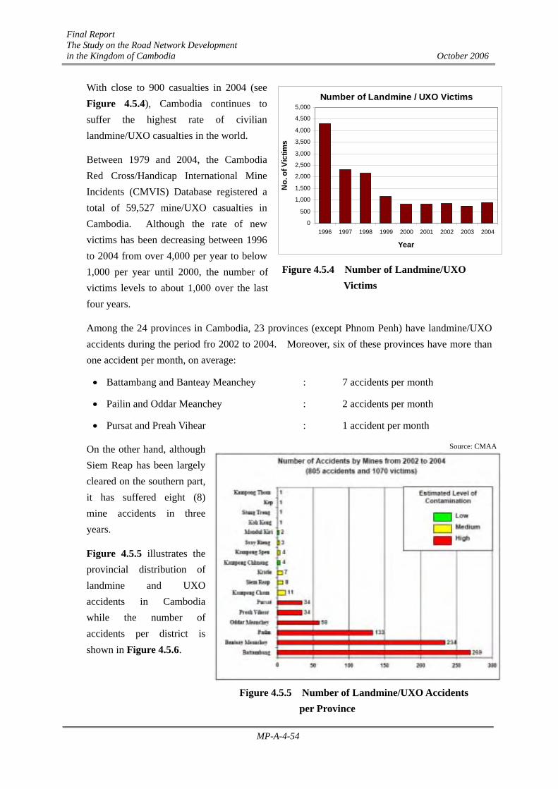
With close to 900 casualties in 2004 (see Figure 4.5.4), Cambodia continues to suffer the highest rate of civilian landmine/UXO casualties in the world.
Between 1979 and 2004, the Cambodia Red Cross/Handicap International Mine Incidents (CMVIS) Database registered a total of 59,527 mine/UXO casualties in Cambodia. Although the rate of new victims has been decreasing between 1996 to 2004 from over 4,000 per year to below 1,000 per year until 2000, the number of victims levels to about 1,000 over the last four years.
Among the 24 provinces in Cambodia, 23 provinces (except Phnom Penh) have landmine/UXO accidents during the period fro 2002 to 2004. Moreover, six of these provinces have more than one accident per month, on average:
• Battambang and Banteay Meanchey : 7 accidents per month
• Pailin and Oddar Meanchey : 2 accidents per month
• Pursat and Preah Vihear : 1 accident per month
On the other hand, although Siem Reap has been largely cleared on the southern part, it has suffered eight (8) mine accidents in three years.
Figure 4.5.5 illustrates the provincial distribution of landmine and UXO accidents in Cambodia while the number of accidents per district is shown in Figure 4.5.6.
Figure 4.5.4 Number of Landmine/UXO Victims
Figure 4.5.5 Number of Landmine/UXO Accidents per Province
Source: CMAA
Number of Landmine / UXO Victims
0
500
1,000
1,500
2,000
2,500
3,000
3,500
4,000
4,500
5,000
1996 1997 1998 1999 2000 2001 2002 2003 2004
Year
No.
of V
ictim
s

Final Report The Study on the Road Network Development in the Kingdom of Cambodia October 2006
MP-A-4-55
Figure 4.5.6 Mine/UXO Accidents by District 2002-2004
4.5.3 Landmine and UXO Clearing Operations
1) Organizations Involved in Mine Clearing Activities
In 1992, Cambodia initiated its mine action program together with the UN Transitional Authority in Cambodia (UNTAC) to rid the country of the mine/UXO problems and clear the land for resettlement of Internally Displaced People (IDP), agriculture, community development, and reconstruction of infrastructure. The Cambodia Mine Action Center (CMAC) and the UN Mine Clearance Training Unit (MCTU) were established in the same year together with several non-governmental organizations including Handicap International, Norwegian Peoples Aid, the HALO Trust and the Mines Advisory Group.
When the mandate of the UN Transitional Authority came to an end, CMAC took over the responsibility for the mine action program in Cambodia and absorbed the MCTU. Under the UNDP project of Assistance to Demining Programmes, CMAC grew rapidly from a small group of local deminers and a few international experts to a national organization employing more than 3,000 deminers and headquarter personnels in 1998. CMAC’s organizational structure for the Executive is established on four functional areas: Mine Awareness, Mine Verification, Mine/UXO Clearance and Training.
0 1-5 6-15 16-35 36-65 66-149
NUMBER OF ACCIDENT BY DISTRICT 2002-2004
Source: CMAA

Final Report The Study on the Road Network Development in the Kingdom of Cambodia October 2006
MP-A-4-56
In 1999, the necessity to reform the mine action program in Cambodia prompted the government to prepare a restructuring plan that will designate a sole national institution tasked with mine action and assistance to mine victims. As part of this plan, the Cambodian Mine Action and Victim Assistance Authority (CMAA) was established, under the direction of the Prime Minister, to regulate and coordinate all mine action operations in the country consistent with the Government’s national development plan. However, CMAC remains as the major element in the overall mine action program and the largest mine action operator in the country.
The Government’s efforts for mine action were backed by the resources deployed under the UNDP Trust Fund (which gave no less than US$ 63million to the program in the period 1993 to 2000) and the funds provided under the bilateral projects. In 2004, CMAC entered into agreement with several development partners and implemented the following bilateral projects apart from the UNDP General Trust Fund:
Table 4.5.2 Mine Action Bilateral Projects
Project Title Project Donor/Partner Project Location
The Integrated Demining and Development Program Netherlands/NPA Cambodia DU1, Banteay Meanchey
The Project to Support CMAC’s Humanitarian Demining Activities Japan DU2, Battambang
Integrated Demining and Development Project CARE Cambodia DU2, Battambang
Project to Support Mine Risk Reduction (MRT) ECHO/HIB DU2, Battambang
Support to CMAC Humanitarian Demining Operation USA DU3, Pailin
The Project to Support Demining of Archeological Sites France DU4, Kompong Thom &
Preah Vihear The Project to Support CMAC’s Humanitarian Demining Activities Japan DU5, Pursat
CMAC-German Project to Support Mine Action Activities Germany DU6, Siem Reap & Oddar
Meanchey CMAC-JMAS Project for UXO Clearance Activities JMAS Prey Veng, Svey Rieng &
Kandal Community-Based Demining Project JMAS DU2, Battambang
Community-Based UXO Risk Reduction KMAS & Rotary Club Kandal and Kampong Speu
Mine Awareness and CBMRR Project UNICEF, HIB and NPA Battambang, Pailin, Banteay Meanchey
*Source: CMAC **DU – Demining Unit
2) Progress in Clearing Operations
The combined response of the Cambodian authorities and the international community to mine action efforts have succeeded in decreasing the casualty rates and returning thousands of hectares

Final Report The Study on the Road Network Development in the Kingdom of Cambodia October 2006
MP-A-4-57
of land to productive agricultural use. The number of mine-related victims has declined steadily over the years from an average of 600 victims per month in 1992 to 74 victims per month in 2004. Moreover, CMAC has been able to free hazardous areas of mine and UXO totaling 145 square kilometers from 1992 to 2005 and has found and destroyed about 310,900 anti-personnel mines, 5,573 anti-tank mines, 1,027,876 UXO and cleared 332,052,440 fragments. Table 4.5.3 presents the details of CMAC’s mine clearing progress.
Table 4.5.3 CMAC’s Mine Clearing Progress
CLEARED/DESTROYED
Progress Period Area Cleared
(m2) Anti-Pers’l
Mine Anti-Tank
Mine UXO Fragments
No. of Clearance
Task
December 2005 2,119,814 4,222 120 8,109 2,740,135
November 2005 1,304,866 1,579 47 6,037 1,581,790
October 2005 1,375,511 1,527 26 6,096 1,866,231
September 2005 1,987,367 3,407 64 11,013 2,611,120
August 2005 2,341,811 7,316 85 14,869 2,750,892
July 2005 1,949,677 5,401 65 14,328 2,232,663
June 2005 1,932,694 3,580 56 12,492 2,063,002
May 2005 2,040,627 9,171 105 13,366 1,679,945
April 2005 1,743,889 10,704 68 12,299 1,407,746
March 2005 2,127,451 16,415 97 10,709 1,853,234
February 2005 1,651,634 5,451 55 9,782 1,575,037
January 2005 1,511,145 5,392 63 9,766 1,505,112
CMAC 2004 11,157,336 43,635 936 106,360 20,804,831 363
CMAC 2003 9,708,686 22,166 504 76,671 21,032,570 344
CMAC 2002 11,582,239 32,688 493 61,840 19,767,069 386
CMAC 2001 9,637,455 16,916 465 77,034 14,069,870 159
CMAC 2000 8,369,635 15,733 628 45,379 20,894,845 232
CMAC 1999 10,797,705 14,322 649 67,610 17,480,591 40
CMAC 1998 12,382,541 13,530 245 47,313 19,583,367 63
CMAC 1997 15,565,421 17,035 266 32,767 12,110,064 34
CMAC 1996 10,493,654 7,126 190 31,574 64,352,250 41
CMAC 1995 10,150,014 22,115 93 47,123 23,670,218 23
CMAC Nov/93-Dec/94 7,865,242 12,126 121 208,845 52,334,579 48
UNTAC Mar/92-Oct/93 5,479,850 19,433 132 96,486 22,085,279 17
Total 2005 22,086,486 74,165 851 128,865 23,866,907
Total 1992-2005 145,276,264 310,990 5,573 1,027,876 332,052,440 2,131
Total 1992-2005: Landmines/UXOs Found and Destroyed = 1,344,439
*Source: CMAC
In 2004, about 11,157,336 square meter of land in 385 sites were cleared by CMAC bringing safe land for the poor and vulnerable people in 289 villages in the high risk areas. The distribution of

Final Report The Study on the Road Network Development in the Kingdom of Cambodia October 2006
MP-A-4-58
the cleared site types is shown in Figure 4.5.7. It is seen that various site functions have been cleared during the year 2004 mine clearing operations including roads and irrigation canals. Although it is indicated in Table 4.5.1 that bridges are also affected by landmine and UXO, no bridge site was cleared in 2004. However, it was noted that several UXO were cleared in Prek Ho bridge construction site in 2005.
Figure 4.5.7 Distribution of Cleared Areas in 2004
4.5.4 Integration of Mine Action with National Priorities
Since 2002, the CMAA has been integrating its mine action program with the Socio-Economic Development Plan and the National Poverty Reduction Strategy. However, to ensure realization of the national development priorities through the mine action operations in Cambodia, CMAA updated its Five Year Mine Action Plan (FYMAP) for 2005 – 2009.
CMAA will strengthen its national coordination framework and obtain from different bodies of the Government, relevant ministries or authorities (including MPWT) their request and own priorities for mine action including specific details on clearance for the forthcoming years. Moreover, CMAA will continue to coordinate mine-action activities in Cambodia through the “National Mine Action Database” (NMAD) which is the primary repository of all mine related information within the Kingdom of Cambodia.
The role of the mine action in poverty alleviation efforts includes creating opportunities for affected communities to use cleared land and assisting in the establishment of livelihood securities for these communities. To achieve this, a constant and active cooperation between the provincial/local authorities and mine action/development agencies is needed. This lead to the establishment of the Provincial Mine Action Committee (PMAC) which is tasked to ensure that each foreseen clearance undertaking is include in the development plan by:
Resettlement16%
Agriculture6%
Health Center2%
Pagoda2%
Others17%
Government Office
2%
School14%
Bridge0%Well
1%
Pond3% Road
22%
Resettlement & Agriculture
10%
Canal Irrigation5%
Source: CMAC

Final Report The Study on the Road Network Development in the Kingdom of Cambodia October 2006
MP-A-4-59
• Integrating the national strategy, national plans and relevant national priorities for mine action;
• Ensuring effective coherence with the provincial and/or commune council’s development plans; and
• Making transparent the demining process with full participation of local authorities, demining agencies, and development organizations.
Provincial Governor
PMAC Districts Communes Villages
Final Report The Study on the Road Network Development in the Kingdom of Cambodia October 2006
MP-A-4-60
4.6 Identification of Bottleneck and Necessary Countermeasures To Be Taken
From the previous sections’ discussions, several problems were identified with the present road network considering road condition, road network and traffic safety. This section will discuss these various concerns and identify measures that will be used for the master plan.
4.6.1 Road Condition Problems and Countermeasures
(1) Road Condition
1) Poor Pavement Condition. At present, only 19.3% of the 11,310kms of national and provincial roads under the jurisdiction of the MPWT is paved with 80.7% unpaved (with either earth or gravel/laterite roads). The condition of these roads varies from good to very poor with about 9.6% (196km) of the 1-Digit road in fair condition which will require rehabilitation in the future if deterioration continues. Moreover, although some secondary roads have been rehabilitated or are undergoing rehabilitation, about 60% of these roads have poor to very poor condition while 90% of the provincial roads are also in poor or very poor condition.
It is the desire of the master plan to provide a minimum of AC pavement for all 1-Digit national roads and at least DBST pavement for other national roads. so that pavement structure will have to be provided for the following:
2) Insufficient Road Width. Depending on the road functional classification, road sections should be provided with shoulders of sufficient width. However, owing to a large number of motorbikes plying Cambodian national roads, some road sections are provided with paved shoulders functioning as motorbike lanes. Although 1-Digit roads are provided with paved shoulders, the shoulders varies from 1.0m to 2.5m. Moreover, more than 62% of the 2-Digit roads and 85% of the provincial roads ( 3 and 4-Digit roads) have road widths less than 6.5m.
The Cambodian Road Design Standard requires at least 3.0m shoulders for the national roads and at least 2.5m for provincial roads. Moreover, at least 2 traffic lanes of standard width shall be provided to national and provincial roads.
3) Insufficient Road Standard for International Routes. In Cambodia, four routes were identified to be part of the international highway network (Asian Highway, ASEAN Highway and GMS Regional Highway). These routes will have to be upgraded to Class I Standard (ASEAN/Asian Highway Standard) with 4 lanes minimum, as follows:
International Highway
Route
Cambodian Road Route
Number Road Length (km)
AH1 NR1, NR5 573.0
AH11 NR4, NR6, NR7 755.0
Total 1,328.0

Final Report The Study on the Road Network Development in the Kingdom of Cambodia October 2006
MP-A-4-61
4) Insufficient Geometric Design Level. Some 2-Digit and 3-Digit roads have low geometric design levels that should be improved to enhance both the traffic capacity and road safety level.
5) Insufficient Road Slope Protection Against Flood. Damage to road embankment slopes including scouring, embankment movement and slope protection damages are observed on flooded sections of national roads.
6) Road Maintenance Problem. Road maintenance has been a key factor to prolong the life of a road, but obviously, lack of road maintenance has caused the deterioration of most roads rendering it impassable during rainy season. Programs to enhance road maintenance will be one focus of the master plan.
(2) Bridge and Culvert Condition Problems and Countermeasures
1) Temporary Bridges. Although much of the road improvement works have been carried-out for 1-Digit primary national roads, at least 26 bridges (NR.2, NR.3 and NR.11) remain to be of temporary type (bailey bridges) with load limit postings. Similarly, in most of the 2-Digit road sections that have been rehabilitated, bridges were not improved due to lack of funds. For the 2-Digit national and 3 & 4-Digit provincial roads, there remain 1,010 bridges which are temporary and about 110 locations without bridges. Moreover, about 17 historical or ancient bridges exist along the 2-Digit roads.
This will require improvement of bridges to the required functional level width carriageway width to be the same as the road width. However, priority should be given to the remaining bridges on 1-Digit and 2-Digit roads that have been improved or rehabilitated.
2) Narrow Permanent Bridges. In some road sections, bridges are found to be narrow, causing traffic bottlenecks and accidents. For the 1-Digit national roads, 31 bridges with carriageway width of less than 7.0m are recorded while 111 bridges with similar narrow width observed in 2-Digit roads. In total, 669 bridges along the national and provincial roads have widths less than 7.0m. Other 2-lane roads have bridges with only one lane causing similar traffic problems. Narrow bridges in good condition should be widened to the required carriageway width (minimum of 2 lanes) while those in poor condition requiring major rehabilitation should be replaced by new bridges.
3) Bridges in Poor Condition. 1-Digit bridge conditions range from good to fair (LRCS survey) and do not require immediate improvement works. However, 2-Digit and 3-Digit road bridge conditions vary from good to poor which requires immediate improvement works or replacement. Moreover, at least 10 bridges for the provincial roads are in the collapsed state while two bridges in the 2-Digit roads (NR.57 and NR.33) collapsed during the course of this

Final Report The Study on the Road Network Development in the Kingdom of Cambodia October 2006
MP-A-4-62
Study. Bridges in poor conditions will have to be addressed with priority to minimize disruption of traffic in the event of collapse.
4) Small Capacity Culvert. Since areas along major rivers and lake are flood prone areas in Cambodia, existing culvert found to be in bad condition or insufficient capacity will have to be replaced.
5) Narrow Box Culverts. Similar to bridges, narrow box culvert are identified in some sections of the road networks. These will either have to be widened or replaced.
(3) Traffic Safety Facilities
1) Poor Provision of Traffic Safety Facilities. It was observed that even some 1-Digit national roads have poor traffic safety facilities (including road markings, traffic signs and warnings, traffic signals, safety rails/barriers, etc.), eg. NR.5, as discussed in traffic condition section. Such road section areas prone for traffic accidents should have sufficient traffic safety facilities. Moreover, national roads classified as international highways should have traffic facilities consistent with the international standard.
(4) Land Mine and UXO Contamination
The Landmine Impact Survey of 2002 indicated about 4,466 square kilometer of land suspected of being contaminated by landmines and unexploded ordnance. This translates to about 6,421 villages with restricted access to houses, agricultural lands, water sources, schools, markets, pagodas, health centers, roads, bridges, forests, etc. Full reconstruction of national infrastructure including roads and bridges are at risk to such contamination making this as one of the problems confronting road network development. Close coordination with CMAA and CMAC is therefore necessary for mine clearing operations to ensure safe development of the road network.
4.6.2 Road Network Problems and Countermeasures
1) Insufficient Bridge Links Crossing Rivers on National and Provincial Roads. At present, there are only three major river crossings in Cambodia – (1) Chruoy Changvar Bridge or the Japanese Friendship Bridge along NR.6 crossing Tonle Sap River, (2) Monivong Bridge along NR.1 crossing Tonle Bassac River, and (3) Kizuna Bridge along NR.7 crossing Mekong River. However, a feasibility study of the fourth bridge crossing Mekong River (Second Mekong Bridge) along NR.1 has been undertaken. In the absence of bridge crossings, ferry services are being operated to cross these major rivers. Moreover, about 110 waterway locations in 2-Digit and provincial roads have no bridge crossing.

Final Report The Study on the Road Network Development in the Kingdom of Cambodia October 2006
MP-A-4-63
It was also observed during the course of the study, collapsed of bridges along major routes have caused traffic and economic disturbance in the affected areas due to lack of alternative routes with bridges.
It is obvious that more major bridge crossings will have to be provided to improve the present road network.
2) Missing Road Links. Road section conditions in some areas are in such poor state rendering it impassable during rainy season. Moreover, although some road alignments were identified, its condition level (road section and geometric level) makes it practically inadequate to convey traffic safely. In other areas, development objectives will require provision of new roads.
3) Low Paved Road Ratio. Cambodia total road network density is comparable to other developing Asian countries, however, the road density of paved roads is still one of the lowest among Asian countries. Therefore, improvement of the road pavement structure to provide a more efficient road network at least until the 3-Digit roads is necessary.
4) Vulnerability to Flood. Investigations conducted by the study team regarding possibility of national roads being submerged to flood in the event of a flood similar to year 2000 occur, indicated that most of the primary national roads will still be passable once on-going and committed rehabilitation works are completed. However, embankment slope protection against the effects of flood must be considered.
5) Traffic Congestion in Major Cities/Areas. It was observed that traffic congestion occurs in major cities or urban areas. This affects traffic movements for long distance trips or through traffic that are not necessary to pass thru these congested areas. Specifically, built-up areas along national roads NR.5 and NR.6 will have to be addressed. The master plan will recommend bypass roads in such congested areas, including Phnom Penh, Battambang, and Siem Reap.
It is also noted that traffic slows down in district centers especially the market areas. Market stalls and parked vehicles occupy most of the shoulders in the market area which narrow down the effective road width and causes through traffic to slow down and build-up along these areas.
Markets will have to be moved away from the major routes to improve traffic flow and traffic safety.