4.4 geology and soils - hcaog€¦ · section 4.4 geology and soils hcaog 4.4-1 4.4 geology and...
TRANSCRIPT

Humboldt Regional Transportation Plan – 2013/14 Update Draft EIR Section 4.4 Geology and Soils
HCAOG 4.4-1
4.4 GEOLOGY AND SOILS 4.4.1 Setting a. Regional Geology. The State of California is divided into distinct geologic provinces. Each of these provinces displays landscapes that are unique and defining based on geology, topographic relief and climate. There are two geologic provinces in Humboldt County, the Coast Ranges province and the Klamath Mountain province. The majority of the County is within the Coast Ranges province, which extends along the coast of California from the Oregon border almost to Point Conception in Santa Barbara County. In Humboldt County, this province is drained by the Mad, Eel, and Mattole River drainages. The Coast Ranges are northwest-trending mountain ranges (generally 2,000 to 4,000 feet, and occasionally 6,000 feet in elevation above sea level), and valleys. The ranges and valleys trend northwest, subparallel to the San Andreas Fault. To the west is the Pacific Ocean. The coastline is uplifted, terraced and wave-cut. The Coast Ranges are composed of thick Mesozoic and Cenozoic sedimentary strata. The northern and southern ranges are separated by a depression containing the San Francisco Bay. The northern Coast Ranges are dominated by the irregular, knobby, landslide topography of the Franciscan Complex. The eastern border is characterized by strike-ridges and valleys in Upper Mesozoic strata. In several areas, Franciscan rocks are overlain by volcanic cones and flows of the Quien Sabe, Sonoma and Clear Lake volcanic fields. The Coast Ranges are subparallel to the active San Andreas Fault. The San Andreas Fault is more than 600 miles long, extending from Point Arena to the Gulf of California. West of the San Andreas Fault is the Salinian Block, a granitic core extending from the southern extremity of the Coast Ranges to the north of the Farallon Islands (California Department of Conservation, California Geological Survey, 2002). The Franciscan and Yager complexes dominate inland, with sand and other alluvial deposits dominating in the lower reaches of the river basins and the area surrounding Humboldt Bay. In the northeast portion of Humboldt County lies the Klamath Mountains Province. In Humboldt County, the province is drained by the Klamath and Trinity Rivers, and farther north, by the Smith River. This Province is characterized by rugged topography with prominent peaks and ridges reaching 6,000-8,000 feet above sea level. In the western Klamath Mountains Province, an irregular drainage is incised into an uplifted plateau called the Klamath peneplain. The uplift has left successive benches with gold-bearing gravels on the sides of the canyons. The Klamath River follows a circuitous course from the Cascade Range through the Klamath Mountains. Rocks in the Klamath Mountains province are generally older than those in the Coast Ranges. Rocks of sedimentary origin such as sandstone, chert, slate, and schist occur abundantly, with occasional granite intrusions. The following summarizes the geology of each planning watershed basin (from Humboldt County General Plan Update Natural Resources and Hazards Technical Report, 2002):
Eel River Basin. The four planning sub-watersheds in the Eel River Basin (South Fork Eel, Lower Eel, Middle Main Eel, and Van Duzen) are generally comprised of highly erodible rocks, including substantial amounts of Franciscan Complex rocks. Over 85% of the Middle Main Eel and 65% of the Van Duzen is Franciscan Complex. The Lower Eel and South Fork Eel

Humboldt Regional Transportation Plan – 2013/14 Update Draft EIR Section 4.4 Geology and Soils
HCAOG 4.4-2
planning watersheds contain some Coastal Belt rocks; both the Lower Eel and South Fork Eel are comprised of over 50% Cenozoic Sedimentary rocks. The Eel River basin is a mountainous area uplifted in recent geologic time (post-Miocene) and underlain by a deformed, faulted, locally sheared, and, in part, metamorphosed accumulation of subducted continental margin deposits. About 99 percent of the bedrock underlying the basin is sedimentary and metasedimentary.
Klamath-Trinity Basin. The Klamath-Trinity Basin, composed of the Lower Klamath, Lower Trinity, and South Fork Trinity planning watersheds, is the only basin with notable amounts of plutonic and metavolcanic rocks. The Humboldt County portion of the basin encompasses the North Coast Ranges province. In the North Coast Ranges, landslides and soil slips are common due to the combination of sheared rocks, shallow soil profile development, steep slopes, and heavy seasonal precipitation. Also, both the Lower Klamath and South Fork Trinity have substantial amounts of Franciscan Complex rocks. Jurassic marine sediments are the predominant bedrock type in the Lower Trinity planning watershed.
Mad-Redwood Basin. The geology of the Mad-Redwood Basin is complex and variable. The basin includes the Mad River, Redwood Creek, Eureka Plain, and Trinidad planning watersheds, which all differ in their bedrock composition. Mad River, Redwood Creek, and Trinidad watersheds are composed primarily of Franciscan rock types, while Eureka Plain is mostly younger sedimentary rock.
Cape Mendocino. About 90% of the Cape Mendocino planning watershed is underlain by Tertiary-Cretaceous Coastal Belt rock. A highly active tectonic setting (see below), combined with sensitive terrain and high rainfall amounts, make the Cape Mendocino one of the most erodible watersheds in the state.
b. Geomorphology and Topography. The most prominent topographic feature in Humboldt County is Humboldt Bay. Humboldt Bay was formed approximately 10,000 to 15,000 years ago, when sea level rose rapidly, flooding stream valleys that previously extended into the current site of Humboldt Bay (Schlosser, Susan; Annie Eicher (2012). Humboldt Bay and Eel River Estuary Benthic Habitat Project. University of California San Diego: California Sea Grant College Program Publication No. T -075). Three rivers, the Mad, Elk and Eel, drained into Humboldt Bay during the mid-Pleistocene. Subsequently, the Mad River cut a new outlet to the sea. The flow of the Eel River was diverted by tectonic uplift, but the Elk River continues to drain into Humboldt Bay. Other minor drainages into Humboldt Bay include: Janes Creek; Jolly Giant Creek; Grotzman/Beith Creeks; Jacoby Creek; Washington Gulch; Rocky Gulch; Freshwater Creek; Ryan Creek; and Salmon Creek. Presently, the Humboldt Bay is split into three regions: the North Bay to the north of Samoa Bridge; the Entrance Bay from Samoa Bridge to South Jetty; and the South Bay which is the remainder of the bay to the south. Daby, Woodley and Indian Island are in the North Bay and all three are within the City of Eureka. Low tides reveal two more islands named Bird Island and Sand Island which were formed from dredge spoils left in the early 20th century. A large eelgrass bed in the South Bay may also be exposed at low tides. At high tide the surface area of the Bay is approximately 24 square miles. However, this surface area is reduced to 10.8 square

Humboldt Regional Transportation Plan – 2013/14 Update Draft EIR Section 4.4 Geology and Soils
HCAOG 4.4-3
miles at low tide. Each tidal cycle replaces approximately 41% of the water in Humboldt Bay (Schlosser, Susan; Annie Eicher, 2012). Humboldt Bay is the only deep water bay for large ocean-going vessels between the San Francisco Bay and Coos Bay, Oregon. The Port of Humboldt Bay (sometimes also referred to as the Port of Eureka) is a deep water port with harbor facilities including large industrial docks at Fairhaven, Samoa, and Fields Landing.
Soil Characteristics. Soil is generally defined as the unconsolidated mixture of mineral grains and organic material that mantles the land surfaces of the earth. Soils can develop on unconsolidated sediments and weathered bedrock. The characteristics of soil reflect the five major influences on their development topography, climate, biological activity, parent (source) material, and time. Humboldt County is one of the few counties in California in which the Soil Conservation Service has not conducted and published a Soil Survey. According to the Humboldt County General Plan, there are a variety of soil types in Humboldt County:
Agricultural/Lowland Soils. The most abundant agricultural and lowland soils found in the County are of the Ferndale series. The Ferndale series soils are deep and well-drained soils formed on recent flood plains. The Bayside and the Loleta series, both deep but poorly drained soils, are found in depressed areas or on nearly level alluvial fans. The Rohnerville, Carlotta and Hookton soils series, all moderately well-drained soils, are found on relatively flat, high marine terraces. The Hookton soils are on sloping, dissected marine terraces, and the Carlotta soils are found on flat, low-lying terraces. Most of these agricultural soils are rated 80-100 (good to excellent productivity) in the Storie Index of agricultural productivity, except for the poorly-drained Bayside soils.
Forest Soils. The forest soils are medium textured and increasing in acidity with depth. They are permeable and well drained. In the lowlands forest soils are formed on alluvial flood plains or low-lying terraces. Here, they are either unclassified or of the Carlotta and Ferndale groups. The most exceptional old growth redwood groves are found on forest soils.
Grassland Soils. The general characteristics of grassland soils vary widely. They range from shallow loamy soils to deep clay soils. Their permeability ranges from moderate to slow. The general nutrient level of these grassland soils is higher than that of the adjacent forest soils. The major portion of these soils is intermingled with other soils in the Douglas fir zone beyond the fog belt. Some of these soils are formed on Franciscan parent material. Many of these are found in the shear zone or fault gouge material or on the melange material of the Franciscan. This parent material weathers rapidly, forming a grey-blue clay subsoil (commonly called "blue goo") that is slippery when wet. Thus, because of the parent material, these soils are prone to landslides.
Woodland Soils. Most of the woodland soils are in inland portions of the County, beyond the cool fog belt. These soils are intermingled with the conifer forest soils of the Douglas fir belt and the adjacent grassland soils. These are shallow soils, usually well drained, but permeability may be slow in some locations. The natural nutrient level of these soils tends to be somewhat higher than for the neighboring forest soils. Because the parent material is predominantly Franciscan melange, these soils are also considered to be relatively unstable.
Humboldt Regional Transportation Plan – 2013/14 Update Draft EIR Section 4.4 Geology and Soils
HCAOG 4.4-4
Alluvial soils. Alluvial soils with a high clay content may be expansive soils, which means they are subject to volumetric fluctuations (“shrink-swell”) due to changes in moisture levels. Typically, site-specific soils testing in these areas is required to determine the level of risk. Highly expansive soils can damage structures built on them unless appropriate engineering mitigation is incorporated into design. c. Seismicity. Primary seismic hazards are ground shaking and ground rupture along the surface trace of faults. Secondary seismic hazards occur when ground shaking interacts with soft or unstable soils (resulting in liquefaction, settlement, or landslide), or when it interacts with open water and results in a tsunami. Another secondary hazard would be ground failure. As a result of ground shaking, rocks and debris may fall from cliffs and steep slopes, and even flat ground may crack or tilt. Fault rupture may occur suddenly during an earthquake or slowly in the form of fault creep. Sudden displacements are more damaging to structures because they are accompanied by shaking. The offshore and coastal regions of Humboldt County contain one of the most geologically complex areas in California. Three major faults, including the San Andreas Fault, the Mendocino Fracture Zone and the Cascade Subduction Zone, all meet where three major plates of the Earth's surface come together: the Pacific plate, the Gorda plate and the North American plate. As a result of this unique and highly seismic geologic setting, Humboldt County is vulnerable to earthquakes. Because much of this area lies under the Pacific Ocean, geological information is limited. Most faults located onshore are oriented in a southeast to northwest course.
San Andreas Fault. The San Andreas Fault system is located just offshore from the southern portion of the county, where the Pacific plate is moving at a rate of about two inches per year to the northwest. The irregular sliding motion, which is almost entirely horizontal, deforms the rocks along the plate boundary until the rocks can no longer withstand the strain. Then, when the rocks shift, energy is released along the fault, causing earthquake shaking.
Falor-Korbel (Mad River) Fault. This fault zone also trends northwest-southeast through the central region of the county. Its northern end is on the coast near McKinleyville and the fault roughly parallels the Mad River.
Trinidad and Big Lagoon Faults. The Trinidad Fault is located near Trinidad, extending northwest to the coast near Trinidad State Beach. The Trinidad fault is potentially capable of generating an earthquake with a moment magnitude of 7.3. The Big Lagoon fault bisects Big Lagoon, north of Patrick’s Point State Park.
Cascadia Subduction Zone. The Cascadia Subduction Zone is where the Gorda plate and its northern extension, the Juan de Fuca plate, collide with the North American plate. The Gorda plate descends beneath the North American plate along the Cascadia subduction zone, which extends approximately 750 miles north to the Canadian border. Downward and eastward motion of the Gorda plate along this subduction zone, beginning at least 6 million years ago and continuing today, produced the volcanic Cascade Range in Washington, Oregon, and northern California. Near its southern end, the subduction zone curves onshore, exposing nine major
Humboldt Regional Transportation Plan – 2013/14 Update Draft EIR Section 4.4 Geology and Soils
HCAOG 4.4-5
thrust faults along the Humboldt County coastline in the vicinity of Cape Mendocino. The major active fault zones in this area include the Cookskie and Petrolia shear zones. The Cookskie Shear Zone contains sheared and broken rock that extends easterly from Punta Gorda. The Petrolia shear zone extends southeast through Petrolia toward along the Mattole River. Until recently, scientists did not consider the Cascadia subduction zone as a major earthquake threat. Prior to the April 1992 Cape Mendocino earthquake, the Cascadia plate boundary was not known to have produced a major earthquake during the past 150 years. New evidence, however, indicates that the subduction zone is active and capable of producing magnitude 8-9 earthquakes (David Oppenheimer, Paul Reasenberg, Steve Walter, Nan Macgregor-Scott, Barry Hirshorn, and Allan Lindh, U.S. Geological Survey. “Seismicity Report for Northern California, the Nation, and the World for the week of April 23 - 29, 1992). Alquist-Priolo Special Studies Zones. In 1972, the California Legislature passed the Alquist-Priolo Earthquake Fault Zoning Act. This action was a direct response to the 1971 San Fernando Earthquake, where extensive surface fault ruptures damaged numerous homes, commercial buildings, freeways and other structures. The purpose of the Alquist-Priolo Earthquake Fault Zoning Act is to prevent the construction of buildings used for human occupancy on the surface trace of active faults. The Act only addresses the hazard of surface fault rupture and is not directed toward other earthquake hazards. However, the Seismic Hazards Mapping Act of 1990 does address non-surface fault rupture earthquake hazards, including liquefaction and seismically induced landslides. Pursuant to the Alquist-Priolo Earthquake Fault Zoning Act, the State Geologist has designated and mapped "Special Studies Zones" and has distributed the maps to all affected cities, counties, and state agencies for their use in planning and controlling development. Before any new development can be permitted within these Special Studies Zones, cities and counties must require a geologic investigation to demonstrate that proposed buildings will not be constructed across active faults. An evaluation and written report of a specific site must be prepared by a licensed geologist. If an active fault is found, a structure for human occupancy cannot be placed over the trace of the fault and must be set back from the fault (generally by 50 feet). Official Maps of Earthquake Fault Zones (EFZ) affecting Humboldt County as of March 1, 2000, are mapped by the Department of Conservation’s Division of Mines and Geology (DMG). The maps focus on the cities of Arcata, Fortuna and Trinidad because these are the areas that are most affected by potentially active faults. These are also the areas where Special Studies Zones have been mapped. Figure 4.4-1 shows the general location of earthquake faults and Special Studies Zones in the county.
d. Liquefaction. Ground settlement and soil compaction may occur as a result of seismic ground shaking. When unconsolidated valley sediments are saturated with water, water is forced to the ground surface, where it emerges in the form of mud spouts or sand boils. If soil liquefies in this manner (liquefaction), it loses its supporting capacity, which can result in the minor displacement to total collapse of structures. These types of unconsolidated sediments represent the poorest kind of soil condition for resisting seismic shock waves. Liquefaction potential is based on the depth of groundwater and alluvial thickness. Research into the process and consequences of liquefaction in past earthquakes has linked liquefaction to certain
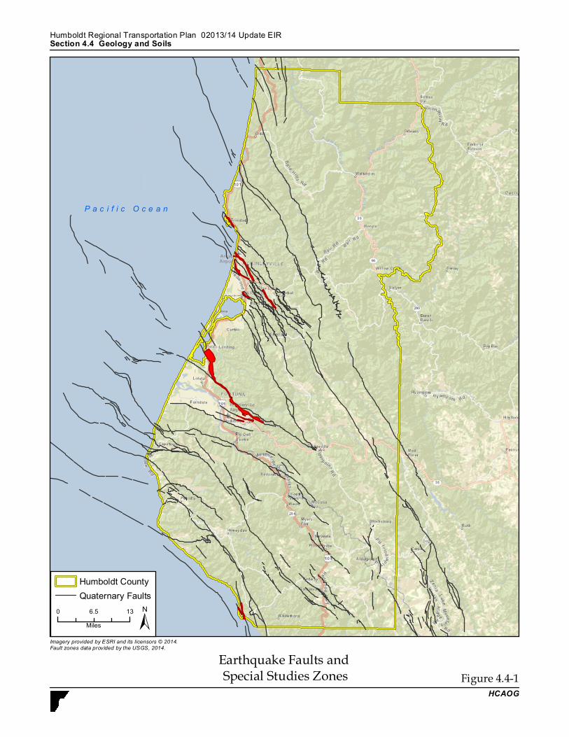
Earthquake Faults and Special Studies Zones Figure 4.4-1
HCAOG
Section 4.4 Geology and SoilsHumboldt Regional Transp ortation Plan – 2013/14 Up date EIR
Imagery provided by ESRI and its licensors © 2014.Fault zones data provided by the USGS, 2014.
±
Humboldt CountyQuaternary Faults
0 136.5Miles
P a c i f i c O c e a n

Humboldt Regional Transportation Plan – 2013/14 Update Draft EIR Section 4.4 Geology and Soils
HCAOG 4.4-7
hydrologic and geologic settings, characterized by water-saturated, cohesionless, granular materials situated at depths of less than 50 feet. The following types of areas are those identified as having a high potential for liquefaction:
• Areas known to have experienced liquefaction during historic earthquakes; • Areas of uncompacted fills that are saturated, nearly saturated or that may become
saturated; • Areas where sufficient existing geotechnical data and analyses indicates a high
liquefaction potential. • Areas containing young (less than 15,000 years) soils where there is limited or no
geotechnical data. Specific areas of high liquefaction potential are located near Humboldt Bay and in the coastal valleys between Ferndale and Arcata, coinciding with the presence of the bay’s muds and sands. Much of the county’s population resides in these areas that are highly vulnerable to liquefaction. Correspondingly, nearly all of the county’s major roadways and urban centers are located in areas where liquefaction could occur in the event of an earthquake. Trinidad does not have a high potential for liquefaction, nor do inland portions of the county. Figure 4.4-2 shows the general location of areas with a high potential for liquefaction.
e. Landslides. Landslides may be triggered by both natural and human induced changes in the environment resulting in slope instability. Precipitation, topography, and geology affect landslides and debris flows. Human activities, such as mining, road construction, and altering surface drainage areas, also affect the landslide potential. Landslides often accompany other natural hazard events, such as floods, wildfires, or earthquakes. They can occur slowly or very suddenly and damage and destroy structures, roads, utilities, and forested areas and cause injuries and death. Landslides generally occur in areas of high seismicity, steep slope, and high rainfall, but may be triggered by any combination of the following: (1) type and structure of earth materials, (2) steepness of slope, (3) water, (4) vegetation, (5) erosion, and (6) earthquake-generated groundshaking. The prediction of slope failure at a specific site, however, requires an analysis of all possible factors, some general and some site-specific. Both the County of Humboldt and California Geological Survey maintain maps depicting possible landslide problem areas. These maps must be used with caution, because it is possible that areas that seem stable may in fact be unstable and vice-versa. Figure 4.4-3 shows the general location of high landslide risk areas.
f. Regulatory Setting. The Alquist-Priolo Earthquake Fault Zoning Act, California’s Alquist-Priolo Act (PRC 2621 et seq.), originally enacted in 1972 as the Alquist-Priolo Special Studies Zones Act and renamed in 1994, is intended to reduce the risk to life and property from surface fault rupture during earthquakes. The Alquist-Priolo Act prohibits the location of most types of structures intended for human occupancy across the traces of active faults and strictly regulates construction in the corridors along active faults (Earthquake Fault Zones). It also

Areas with a High Liquefaction Potential Figure 4.4-2HCAOG
Section 4.4 Geology and SoilsHumbo ldt Regio nal Transpo rtatio n Plan – 2013/14 Update EIR
Imagery provided by ESRI and its licensors © 2014.Liquefaction data provided by County of Humboldt,
±0 136.5Miles
P a c i f i c O c e a n
Humbo ldt Co untyLiquefaction Zone
A0A2B0C0
C2D0D2

High Landslide Risk Areas Figure 4.4-3HCAOG
Section 4.4 Geology and SoilsHumboldt Regional Transp ortation Plan – 2013/14 Up date EIR
Imagery provided by ESRI and its licensors © 2014.Slope Stability data provided by County of Humboldt, 2014.
±
Humboldt CountySlope Stability
3 High Instability2 Moderate Instability1 Low Instability
0 136.5Miles
P a c i f i c O c e a n
Humboldt Regional Transportation Plan – 2013/14 Update Draft EIR Section 4.4 Geology and Soils
HCAOG 4.4-10
defines criteria for identifying active faults, giving legal weight to terms such as “active,” and establishes a process for reviewing building proposals in and adjacent to Earthquake Fault Zones. Under the Alquist-Priolo Act, faults are zoned, and construction along or across them is strictly regulated if they are “sufficiently active” and “well-defined.” A fault is considered sufficiently active if one or more of its segments or strands shows evidence of surface displacement during Holocene time (defined for the purposes of the act as within the last 11,000 years). A fault is considered well-defined if its trace can be clearly identified by a trained geologist at the ground surface or in the shallow subsurface, using standard professional techniques, criteria, and judgment (Hart and Bryant 1997). The California Building Standards Code (CBSC) is based on the Uniform Building Code (International Code Council 1997), which is used widely throughout United States (generally adopted on a state-by-state or district-by-district basis). For California conditions, it has been modified with numerous, more detailed or more stringent regulations. The CBSC provides standards for various aspects of construction, including (i.e., not limited to) excavation, grading, and earthwork construction; fills and embankments; expansive soils; foundation investigations; and liquefaction potential and soil strength loss. In accordance with California law, proponents of specific projects would be required to comply with all provisions of the CBSC for certain aspects of design and construction. The California Department of Transportation (Caltrans) has Seismic Design Criteria (SDC), which is an encyclopedia of new and currently practiced seismic design and analysis methodologies for designing new bridges in California. The SDC adopts a performance-based approach that specifies minimum levels of structural system performance, component performance, analysis, and design practices for ordinary standard bridges. The SDC has been developed with input from the Caltrans Offices of Structure Design, Earthquake Engineering and Design Support, and Materials and Foundations. Caltrans’ “Memo 20-1” outlines the bridge category and classification, seismic performance criteria, seismic design philosophy and approach, seismic demands and capacities on structural components and seismic design practices that collectively make up Caltrans’ seismic design methodology. To protect against geological hazards, the County has adopted policies in its General Plan Safety Element and has adopted the California Uniform Building Code and a Grading Ordinance. Incorporated cities within the County have also done so. These policies and regulations include preventative measures to protect lives, health, property and public welfare from hazards related to geology and soils. In addition, Humboldt County Ordinance 2203 established an integrated Emergency Operations Plan for Humboldt County, including all cities and special districts. The Office of Emergency Services (OES) is responsible for maintaining the Humboldt County Emergency Operations Plan, which serves to address the planned response to extraordinary emergency situations associated with a natural disaster, technological incident, or national security emergency. 4.4.2 Impact Analysis
a. Methodology and Significance Thresholds. In accordance with the Appendix G of the CEQA Guidelines, a project would result in a significant impact if the project would:

Humboldt Regional Transportation Plan – 2013/14 Update Draft EIR Section 4.4 Geology and Soils
HCAOG 4.4-11
• Expose people or structures to potential substantial adverse effects, including the risk of loss, injury, or death involving rupture of a known earthquake fault, strong seismic ground shaking, seismic-related ground failure, including liquefaction, or landslides;
• Result on substantial soil erosion or the loss of topsoil; • Result in the loss of a unique geologic feature; • Be located on a geologic unit or soil that is unstable, or that would become unstable as a
result of the project, and potentially result in on- or off-site landslide, lateral spreading, subsidence, liquefaction, or collapse;
• Be located on expansive soil, creating substantial risks to life or property; or • Have soils incapable of adequately supporting the use of septic tanks or alternative
wastewater disposal systems where sewers are not available for the disposal of wastewater.
As discussed in the Initial Study (see Appendix A), the proposed RTP does not include projects that contain septic systems. Therefore the RTP would not result in impacts related to soils incapable of supporting septic systems and these issues will not be further addressed within this EIR. The RTP is also not anticipated to result in any significant impacts on unique geologic features in the county. Therefore, this threshold is not discussed further in this impact analysis. Refer to Section 4.6, Hydrology and Water Quality, for a discussion of RTP impacts related to erosion.
b. Project Impacts and Mitigation Measures. This section describes generalized impacts associated with some of the projects anticipated under the RTP.
Impact GEO-1 Future seismic events could produce ground shaking throughout Humboldt County as well as surface rupture in some areas. Ground shaking and surface rupture could damage structures and/or create adverse safety effects. However, compliance with local policies, in combination with the requirements of the California Uniform Building Code and Alquist-Priolo legislation, would reduce the risk associated with ground shaking and surface rupture to Class III, less than significant.
In general, groundshaking and fault rupture is a geologic hazard that is prevalent throughout California. Humboldt County is subject to severe ground shaking from any of a number of faults in the region, including those known to exist offshore. As shown in Figure 4.4-1, the County is braided with historic faults. Alquist-Priolo Special Studies Zones have been mapped and the California Department of Conservation has made the maps available to all affected jurisdictions. Due to the programmatic nature of the RTP, a precise, project-level analysis of the specific impacts of individual transportation projects on seismic hazards is not possible at this time. In general, however, implementation of proposed transportation improvements in the RTP could be exposed to fault rupture and groundshaking. In essence, all projects under the RTP would be subject to some level of groundshaking.
Humboldt Regional Transportation Plan – 2013/14 Update Draft EIR Section 4.4 Geology and Soils
HCAOG 4.4-12
As indicated by Figure 4.4-1, projects located in and between Carlotta, Fortuna, Loleta, and Fields Landing communities, and in the Arcata, McKinleyville and Trinidad areas would be most susceptible to seismic hazards. In particular, large portions of Fields Landing, Arcata and McKinleyville are within active fault zones. Bridge-type structures are most susceptible to earthquake groundshaking and fault rupture; however, structures as well as roadways may also be damaged by either phenomenon. The RTP includes many projects that could be subject to seismic hazards due to their location. Any new development within the Special Studies Zones would have to be evaluated by a professional geologist and would have to include appropriate design features and setbacks. All public transportation improvements are engineered, and new non-transportation development within the Plan Area would conform to the Alquist-Priolo Earthquake Fault Zoning Act, California Building Code (CBC), and local grading ordinance. This adequately addresses potential impacts relating to surface rupture and ground shaking and would ensure that impacts are less than significant.
Mitigation Measures. No mitigation is required.
Significance After Mitigation. Impacts would be less than significant without mitigation.
Impact GEO-2 Future seismic events could result in liquefaction of soils in portions of the Plan Area. Development in certain areas within the Plan Area could be subject to liquefaction hazards. This impact is considered Class II, potentially significant but mitigable.
Liquefaction potential is widespread throughout the county, particularly in lower-lying valleys overlaid by alluvium, as shown on Figure 4.4-2. Such areas are also typically characterized by high groundwater. This condition is most prevalent near Humboldt Bay and in the coastal valleys between Ferndale and Arcata. Many of the County’s major roadways and urban centers are located in such areas. Consequently, the majority of RTP transportation improvement projects involving structural change or new facilities could be subject to liquefaction. These hazards could be exacerbated through grading associated with transportation projects, and construction of such projects on unconsolidated fill. The identification of on-site geologic hazards would require the preparation of project-specific geotechnical evaluations for proposed RTP projects. Due to the programmatic nature of the RTP, such detailed evaluation would only be required upon implementation of a given RTP project. The preparation of project-specific geotechnical evaluations prior to implementation of RTP projects would identify and evaluate geologic hazards for that particular project site. Generally, the analysis would provide recommendations to prepare sites for development to avoid the identified geologic hazards. Mitigation Measures. HCAOG shall, and sponsor agencies can and should, implement the following mitigation measures for potential impacts associated with liquefaction.
GEO-2 If an RTP project is located in an area of moderate to high liquefaction potential, the local jurisdiction in which this project is located shall ensure that the project is designed based upon
Humboldt Regional Transportation Plan – 2013/14 Update Draft EIR Section 4.4 Geology and Soils
HCAOG 4.4-13
appropriate geology, soils and earthquake engineering studies. Possible design measures include deep foundations, removal of liquefiable materials and dewatering.
Significance After Mitigation. Implementation of Mitigation Measure GEO-2 would
reduce potential impacts to a less than significant level.
Impact GEO-3 Transportation projects in the proposed RTP may be located in areas with expansive soils and/or landslide hazards that could damage structures and present safety risks. This impact is considered Class II, significant but mitigable.
Expansive soils have a clay content and mineralogy that renders them susceptible to volume increase when they absorb water and volume decrease when they dry. RTP roadway projects located on expansive clay soils could be damaged by repeated cycles of wetting and drying. In particular, the Bayside Silty Clay Loams (Ba2, Ba3 and Ba6) found in the alluvial lowlands and in the vicinity of Humboldt Bay have a high shrink-swell potential and are therefore considered expansive. Historically, most landslides in Humboldt County have occurred in remote uninhabited portions of the county where slopes are excessively steep (Historic Landslides Map, Humboldt County GIS Portal, December 26, 2013). The identification of on-site geologic hazards would require preparing project-specific geotechnical evaluations for proposed RTP projects. Due to the programmatic nature of the RTP, such detailed evaluation would only be required upon review of a given RTP project. The project-specific geotechnical evaluations prepared prior to implementing RTP projects would identify and evaluate geologic hazards for that particular project site. Generally, the analysis would recommend preparing sites for development to avoid the identified geologic hazards. Nonetheless, because projects under the proposed RTP would potentially be exposed to expansive soils and landslide hazards, potential impacts would be Class II, significant but mitigable. Mitigation Measures. HCAOG shall implement, and sponsor agencies can and should implement, the following mitigation measures to reduce potential impacts associated with expansive soils and landslides.
GEO-3(a) If an RTP project involves cut slopes over 15 feet in height, the local jurisdiction in which the project is located shall ensure that specific slope stabilization studies are conducted. Possible stabilization methods include buttresses, retaining walls and soldier piles.
GEO-3(b) If an RTP project is located in an area of expansive soils, the
local jurisdiction in which the project is located shall ensure that a site-specific geotechnical investigation is conducted. The investigation will identify hazardous conditions and recommend appropriate design factors to minimize hazards. Such measures could include concrete slabs on grade with increased steel reinforcement, removal of highly expansive

Humboldt Regional Transportation Plan – 2013/14 Update Draft EIR Section 4.4 Geology and Soils
HCAOG 4.4-14
material and replacement with non-expansive import fill material, or chemical treatment with hydrated lime to reduce the expansion characteristics of the soils.
Significance After Mitigation. Implementation of Mitigation Measures G-3(a) and G-3(b) would reduce potential impacts to a less than significant level.
c. Specific RTP Projects That May Result in Impacts. All RTP projects that require new construction or landscaping may create impacts as discussed in Section 4.4.2.b above and are therefore not mentioned in a table format. Individual projects could create significant impacts to geologic resources but would not necessarily do so. Additional specific analysis will need to be conducted as the individual projects are implemented in order to determine the actual magnitude of impact. Mitigation measures discussed above could apply to these specific projects.