4.5 cultural resources - california public utilities … cultural resources proponent’s...
TRANSCRIPT

4.5 CULTURAL RESOURCES
Proponent’s Environmental Assessment Page 4.5-1West of Devers Upgrade Project October 2013
4.5 Cultural Resources
This section describes the cultural (i.e., archaeological and historical) and paleontological resources in the area of the Proposed Project. Appendix D contains the results of Native American outreach to date, and Appendix G contains cultural and paleontological technical studies. The potential impacts of the Proposed Project and Alternative Project are also discussed. For the purposes of this section, the Area of Potential Effects (APE)/Project Study Area is defined as the area encompassing all of the following: (1) the existing and proposed right-of-way (ROW) for the West of Devers (WOD) Upgrade Project; (2) the existing and proposed access roads associated with the Proposed Project, 25 feet from centerline on each side for a total buffer width of 50 feet; (3) the proposed telecommunications route, 25 feet from centerline on each side for a total buffer width of 50 feet; (4) the proposed 66 kV subtransmission lines, 25 feet from centerline on each side for a total buffer width of 50 feet; and (5) the proposed staging yards outside the existing WOD corridor (see Appendix G, Cultural Resources, Cultural and Paleontological Project Study Area Figure). The buffer width allows for documentation of resources adjacent to the project limits to address any future minor modifications to the Proposed Project preliminary design.
4.5.1 Cultural Resources Environmental Setting
4.5.1.1 Geographic and Geologic Setting
Geographic Setting
The APE/Project Study Area includes the cities of Banning, Beaumont, Calimesa, Colton, Grand Terrace, Loma Linda, Palm Springs, Rancho Cucamonga, Redlands, San Bernardino, and Yucaipa, and unincorporated areas of Riverside and San Bernardino counties including portions under the jurisdiction of the Bureau of Land Management (BLM) and the Morongo Reservation. The Proposed Project component in the City of Rancho Cucamonga is limited to improvements within the Mechanical Electrical Equipment Room (MEER) at Etiwanda Substation. The extent of this work within an existing facility would not have the potential to affect cultural resources in the City of Rancho Cucamonga; therefore, the City of Rancho Cucamonga is not included for further discussion.
The APE/Project Study Area for the Proposed Project is located where the San Gorgonio Pass forms a natural break between the San Bernardino Mountains to the north and the San Jacinto Mountains to the south. The APE/Project Study Area includes the Coachella Valley at Devers Substation and continues west into San Timoteo Canyon to San Bernardino Substation. The APE/Project Study Area crosses Scott Canyon, parallels San Timoteo Canyon, passes through the San Gorgonio Pass, and terminates just west of Devers Hill. Major drainages include the Whitewater River, the San Gorgonio River, Noble Creek, and Little San Gorgonio Creek. The APE/Project Study Area crosses the Colorado River Aqueduct, and multiple unnamed drainages pass through the area. The elevation in the APE/Project Study Area ranges from approximately 950 feet above mean
4.5 CULTURAL RESOURCES
Page 4.5-2 Proponent’s Environmental AssessmentOctober 2013 West of Devers Upgrade Project
sea level (amsl) at the western end of the Proposed Project (Vista Substation), to 3,000 feet amsl southwest of the San Gorgonio River.
Geologic Setting
The APE/Project Study Area is located in San Gorgonio Pass and San Timoteo Canyon. The San Gorgonio Pass is east-to-west trending lowland, forming a natural break between the San Bernardino Mountains to the north and the San Jacinto Mountains to the south. The surface of the lowland is derived from alluvial fan deposits, mainly from the San Bernardino Mountains. The northern foothills are underlain by upper Cenozoic non-marine and marine sedimentary deposits (Morton 1999). San Gorgonio Pass drains to the east into the Coachella Valley and to the west into the Los Angeles Basin. One of the major drainages to the west of the pass is San Timoteo Canyon, which trends generally in an east-west direction. The canyon bisects terraced badlands that are composed of Quaternary and Tertiary non-marine sediments that date from the Pliocene to the Pleistocene. The pass and canyon areas are composed of late Holocene wash deposits that cut into younger alluvial deposits that date from the late Pleistocene to the early Holocene. There are exposures of older alluvial and channel deposits from the middle to late Pleistocene that derive from the surrounding mountains (Ibid.).
4.5.1.2 Cultural Setting
Prehistoric Setting
The prehistory of the southern California desert regions is typically divided into three or four time periods, each representing a segment of time starting with the earliest inhabitants of North America around 15,000 years ago. Each of these periods represents significant changes in cultural material or human behavior. Bettinger and Taylor (1974:1–26) and Warren and Crabtree (1986:183–193) both present desert chronologies based on temporal periods using radiocarbon-dated projectile point types as period markers. Based on these desert chronologies, the Holocene Model has been used to organize prehistoric culture change over time. For this study, three major time periods are described, covering the last 10,000–15,000 years (the Holocene Epoch): Early Holocene, Middle Holocene, and Late Holocene.
During the Early Holocene, approximately 12,000–7,000 years before present (BP), the area between San Bernardino and the San Gorgonio Pass was occupied by Native American people (Moratto 1984:110–113). This initial occupation of prehistoric southern California was labeled “Early Man” or “Horizon I” by Wallace (1955). Early Holocene cultures of California have been interpreted as diversified foraging economies (Moratto 1984:79–88; Erlandson 1994:44–45).Some Early Holocene artifacts, such as large, fluted bifacial spear points, suggest a predominantly hunting culture based on following now extinct megafauna, such as mammoth (Wallace 1955; Moratto 1984:81). The Middle Holocene, approximately 7,000–3,500 years BP, is represented by cultures shifting from hunting large game to a more focused economy based on small game and foraging. Flaked stone artifacts from this period include weakly-shouldered, concave-base Pinto points, large and small leaf-shaped bifaces, domed and keeled scrapers, and an abundance
4.5 CULTURAL RESOURCES
Proponent’s Environmental Assessment Page 4.5-3West of Devers Upgrade Project October 2013
of core and cobble tools. Groundstone implements, including large slightly modified metates, small, thin extensively used metates, and both shaped and unshaped manos indicate an increase in reliance on seed processing (Hall 1993:21; Horne and McDougall 1997:9).
The Late Holocene cultures in the Mojave Desert existed from approximately 3,500 years BP to historic contact in the 19th century. Groundstone tools persisted into this period, and are typically more abundant. Flaked stone artifacts include Gypsum, Humboldt, and Elko series projectile points, and leaf-shaped points, rectangular-based knives, T-shaped drills, and occasionally large scraper planes, chopper and hammer stones (Warren 1984:416; Horne and McDougall 1997:9). Manos and metates are common, and use of the mortar and pestle first occurs during this period. Other artifacts include arrow shaft straighteners, incised slate and sandstone tablets and pendants, bone awls, shell beads and ornaments. In the Coso area, which is approximately 150 miles north-northwest of the APE/Project Study Area, more unique artifacts such as Rose Spring projectile points occur with split-twig figurines and bow-and-arrow petroglyphs suggesting cultural similarities with groups in northern Arizona (Warren and Crabtree 1986:189; Grenda 1998:18). During this period, the presence of ceramics, obsidian, and other material from the Colorado Desert region reflects cultural shifts in trade and exchange. New sources of obsidian, including Obsidian Butte near the Salton Sea, were previously inaccessible. Brown ware pottery from desert cultures was introduced into the APE/Project Area during this period, representing exchange and influence between cultural groups.
Ethnographic Setting
The majority of the APE/Project Study Area was occupied by natives of the Takic (Shoshonean) language family. While the APE/Project Study Area is located near the intersection of the traditional tribal boundaries of the Serrano and Cahuilla, it is primarily within Cahuilla territory. The traditional tribal boundaries of the Gabrielino (Tongva) are west of the APE/Project Study Area, and the Chemehuevi are east of the APE/Project Study Area.
Cahuilla territory is located near the geographic center of southern California within the inland basin between the San Bernardino Mountains and the range extending southward from Mt. San Jacinto, along with some western coastal drainage areas (Kroeber 1925:693). Natural physiographic features such as mountains, deserts, and plains, separated the Cahuilla from their nearest native neighbors (Bean 1978:575). The Cahuilla occupied almost all but the extreme northwestern portion of the APE/Project Study Area near San Bernardino, which was occupied by the Serrano.
The Cahuilla practiced a hunter-gatherer lifestyle and lived in semi-permanent communities located near water such as springs, wells, or streams. These village locations were often occupied seasonally, but the general location remained consistent for a number of years. The most important factors for choosing a community site were the presence of a stable food supply, water, and some measure of protection from wind, cold in winter, and heat in summer (James 1960). Among the chief foods of the Cahuilla were
4.5 CULTURAL RESOURCES
Page 4.5-4 Proponent’s Environmental AssessmentOctober 2013 West of Devers Upgrade Project
acorns and mesquite seeds. Other foods included western juniper, pine nuts, yucca, cactus, rabbit, and deer (Barrows 1971; James 1960).
In the 1860s, the Cahuilla outnumbered Euro-Americans; however, the smallpox epidemic of 1862–1863 decimated the Native populations. They were rapidly replaced by the Euro-Americans who continued to move into the region with the availability of land, and their plight attracted national attention (Bean et al. 1981). In 1877, reservations were created for the Cahuilla, including Morongo Band of Mission Indians (Morongo), Torres-Martinez, Los Coyotes, Santa Rosa, and Agua Caliente.
The northwestern portion off the APE/Project Study Area falls along the traditional boundary between the Luiseño and the Serrano (Kroeber 1925:648). For the purposes of this study, however, the group that most likely occupied the majority of the APE/Project Study Area was the Serrano. Elements of the Serrano culture are presented below.
The very northwestern portion of the APE/Project Study Area was occupied by indigenous peoples known as the Serrano, whose name in Spanish means “mountaineer” or “highlander” (Kroeber 1925:615; Bean and Smith 1978:570). Serrano territory included the area from Cajon Pass east to a point approximately 20 miles east of Twentynine Palms, and the San Bernardino Mountains north of San Gorgonio Pass north into the Mojave Desert to a point south of Barstow and Daggett (Kroeber 1925:615–616; Bean and Smith 1978:571). Kroeber also states that the Serrano occupied a stretch of fertile lowland from Cucamonga east to above Mentone, and halfway up San Timoteo Canyon that is sometimes said to have been Gabrielino territory (Kroeber 1925:615–616).
The Serrano were hunter-gatherers. In general, men hunted and fished and the women gathered acorns and piñon nuts, which were supplemented with roots, bulbs, shoots, and seeds. They hunted deer, mountain sheep, antelope, rabbits, and quail. Meat was prepared in earth ovens or boiled. Surplus meats and vegetable foods were sun-dried for later use. The Serrano used metates, mortars, flint knives, scrapers, bowls and trays made of pottery, baskets, horn and bone spoons as utensils for preparing food (Bean and Smith 1978:571).
Serrano villages were placed near permanent water. Their dwellings were circular, domed structures built of willow and thatch. The house served primarily for sleeping and storage, other activities were carried out outside or under a ramada1 (Bean and Smith 1978:571). The villages had a large ceremonial house where the leader lived. The ceremonial house was the religious center for the Serrano. Other village structures included a granary and a sweat house (Ibid.).
Contact may have been made by the Spanish as early as 1771 or 1772, but their influence was negligible until about 1819 when the estáncia2 was established near present day Redlands. Subsequent to that date, the Serrano were removed to the missions.
1 An open shelter, often having a dome-shaped thatched roof. 2 A mission outpost.
4.5 CULTURAL RESOURCES
Proponent’s Environmental Assessment Page 4.5-5West of Devers Upgrade Project October 2013
The current Reservation Trust Land of the Morongo Band of Mission Indians (Reservation) extends over approximately 36,000 acres or 55 square miles of Tribal Trust, Individual Trust and Tribally owned fee land in the pass below San Gorgonio and San Jacinto Mountains in Riverside County. The Reservation was established by an Executive Order by President Rutherford B. Hayes in 1878 and was constantly under pressure from encroachment Anglo-European settlers and unclear boundary lines (Mathes and Brigandi 2009:89–118). The Reservation and casino now employs over 3,000 people from the reservation and the surrounding areas (Morongo n.d.). Currently, Serrano and Cahuilla descendants live on the Reservation, although members from other groups including the Cupeño, Luiseño, Chemehuevi, Gabrielino, Paiute, and Kumeyaay have also moved to the Reservation (Schulman 2009). The Reservation continues to support the local community, and offers classes and information regarding the traditional lifeways of the Serrano and Cahuilla through its Cultural Heritage Program and community outreach activities (Morongo n.d.).
Historic Setting
Spanish Period. The historic period in California began with the establishment of Spanish Colonial military outposts and missions, the first of which were the Presidio and Mission San Diego de Alcalá, both built in 1769 in the present-day City of San Diego. That same year, Gaspar de Portolá led an expedition through the coastal areas of southern California.
The 1770s saw a number of expeditions and surveys travel across the area, including that of Pedro Fages, who led a group across the area while pursuing deserters from the San Diego Presidio. Juan Bautista de Anza traveled through present-day Riverside County in 1775–76 searching for an overland route between Sonora, Mexico and the Monterey/San Francisco region in Alta California.
Mission San Gabriel Arcángel was established by Franciscan fathers in the San Gabriel Valley (Los Angeles) in 1771. The fathers also set up 27 outlying estáncias to supply the mission with meat, hay, grain, vegetables, and fruits. Two of these estáncias, the San Bernardino Rancho (Guachama) and the San Gorgonio Rancho, are located in the vicinity of the APE/Project Study Area.
In 1819, the Mission Fathers from San Gabriel, with Indian labor, erected the Guachama Estáncia (in present-day Loma Linda). Cattle ranching and farming occurred here, providing supplies to San Gabriel and the workers of the estáncia. In 1830, the estáncia was relocated one mile southeast from the original site to its present location on Barton Road at the head of San Timoteo Canyon. The Guachama Rancheria is listed as a California Registered Historical Landmark (No. 95).
In addition to the estáncia at Guachama, the San Gorgonio Rancho was established by 1823 but not formally recorded. In similar fashion to Guachama, this ranch raised cattle and sheep and pursued land cultivation. Due to the distance between the rancho and San Gabriel Mission, the rancho land was strictly used for grazing livestock.
4.5 CULTURAL RESOURCES
Page 4.5-6 Proponent’s Environmental AssessmentOctober 2013 West of Devers Upgrade Project
Mexican Period. The Decree of Secularization, passed in 1834, ended the Mission period in California. The missions were no longer under the control of the Spanish padres, as Mexico gained independence from Spain. The estáncias of San Bernardino and San Gorgonio were abandoned. The following years were marked by the proliferation of ranching throughout the region, as the Mexican Governor granted vast tracts of land (ranchos) to Mexican (and some American expatriates) settlers who would colonize the area and develop the land, generally for grazing cattle and sheep. On account of the natural flow of water from the various canyons, all the ranchos in the area were located on the north hills of the Pass.
The land of the San Timoteo Rancho in San Timoteo Canyon was granted to James (Santiago) Johnson, an English trader, who had arrived in California in 1833 after eight years in Guaymas, Mexico. In April 1845, apparently in dire financial straits, Santiago Johnson sold the land to Louis Robidoux (Beattie and Beattie 1951). Robidoux arrived in California in 1843 with a group of settlers from New Mexico at the invitation of the Lugo family, who had been granted the Rancho San Bernardino the previous year. Constantly having to protect their livestock from depredations by the Paiute and other Indians from the east, the Lugos sold their rancho to the Mormons in 1851 and returned to Los Angeles (Hornbeck 1913).
Although commonly referred to as one of the ranchos established in the Pass, the San Gorgonio Rancho was actually never recorded as a Mexican land grant. In 1845, Colonel Isaac Julian Williams, Wallace Woodruff, and Paulino Weaver petitioned Governor Pio Pico for a grant to the land of the San Gorgonio Rancho (Lech 2004:37–38). The San Gorgonio Rancho consisted of approximately 11 leagues3 of land and contained territory now occupied by Banning and Beaumont (Holmes 1912:177).
American Period. Following the signing of the Treaty of Guadalupe Hildago in 1848, the United States gained possession of California. An increase in American settlers to the area led to a boom in development of the region. Native American groups and a number of early settlers chose San Timoteo Canyon to establish homesteads and ranches, including individuals such as Duff Weaver, Dr. St. Claire, Manuel Acosta, James Singleton, Newton Noble, and Michael Vanderventer. Each of these early inhabitants left an indelible mark on the region, contributing to the initial growth of later cities and communities. Duff Weaver, for example, became good friends with a local Cahuilla Indian chief, Juan Antonio. The two worked together to reduce stress between white settlers and Native Americans, achieving a successful, albeit short-lived, balance in the San Timoteo Canyon area. Dr. St. Claire was San Timoteo Canyon’s first teacher, providing lessons in a local adobe building for the children in the region. Today, Dr. St. Claire’s property is used as a vacation locale, called Fisherman’s Retreat. The historic lakes are stocked with fish and the property features swimming pools, playgrounds, and
3 During Spanish rule, the ranchos were concessions from the Spanish crown, permitting settlement and granting
grazing rights on specific tracts of land, while the crown retained the title. The land concessions were usually measured in leagues. A league can be linear unit of measure and can also be a unit of area measurement, used to define the area of land ownership. A league of land is approximately 4,428 acres (18 km2). Measurement in leagues was used in the archaic system of old Spanish land grants.
4.5 CULTURAL RESOURCES
Proponent’s Environmental Assessment Page 4.5-7West of Devers Upgrade Project October 2013
recreational rooms. The Singleton Ranch began in 1868 with James Singleton, and the property occupies a large tract of land within the APE/Project Study Area.
Michael Vanderventer, assisted by local farmers, built the San Timoteo School House in 1883 and was the Secretary of the San Timoteo School District (Shanks 1994).
Newton Noble was born in Cayuga County, New York, in 1834, and came to San Bernardino in 1852. Noble and his partner Byron Waters established a stage coach stop and post office on the ranch, bringing the first reliable service through the canyon (Shanks 1994:61). In addition to managing a ranch, running stage coach lines through the Pass, and establishing a post office, Noble was elected the Sheriff of San Bernardino County for two terms between 1869 and 1873 (Shanks 1994; San Bernardino County Sheriff’s Office 1973; White 1886).
Settlers also established ranches and other endeavors in San Gorgonio Pass region. By 1854, Joe Pope established a residence north of present-day Banning adjacent to a small spring called Antonio Creek. In the mid-1860s, Newton Noble established a stage stop on the original Pope Ranch to provide stage coaches with meals, lodging, and fresh horses for their journey to the east along the Bradshaw Trail. He also opened the first post office in the San Gorgonio Pass region in 1868 (Gunther 1984:199). After several decades, the ranch produced oranges, figs, grapes, almonds, olives, prunes, apricots, and apples, and became one of the most successful ranches (Gilman Ranch) in San Gorgonio Pass region by the beginning of the 20th century.
One of the most influential Native Americans in San Timoteo Canyon was Juan Antonio, a Mountain Cahuilla chief. He was born circa 1800 in the San Jacinto Mountains (Smith et al. 1960). Juan Antonio first appears in the historical record in 1842 at Rancho San Bernardino, working for José del Carmen Lugo, José María Lugo, Vicente Lugo, and Diego Sepúlveda after they were granted the rancho. He avoided the influence of San Gabriel Mission, and maintained a strong following of other Cahuilla residents in the region (Smith 1960:1–36). Juan Antonio’s influence in the region was not diminished by the transfer of power from Mexico to the United States after the secession of California to the Americans in 1848. The Indian leader continued protect the Lugo family holdings and was considered the authority to turn to in all matters concerning the Cahuilla.
The discovery of gold in California resulted in an influx of thousands of settlers with little regard for existing communities. New American families began squatting on Indian property in the region, causing stress on resources and increasing discord between the Indians and the settlers. Juan Antonio met with local tribes and the United States Army to discuss solutions, with few successful results. Gold was discovered in the San Bernardino Mountains in 1859, leading to more aggressive clashes between the Indians and white settlers.
By the fall of 1862, a smallpox epidemic struck Los Angeles and quickly spread throughout southern California. The inhabitants of Saahatpa, Juan Antonio’s village, fled San Timoteo Canyon, heading for the desert or the mountains. Juan Antonio eventually fell victim to smallpox and was buried at Saahatpa, near the present El Casco School
4.5 CULTURAL RESOURCES
Page 4.5-8 Proponent’s Environmental AssessmentOctober 2013 West of Devers Upgrade Project
(Smith 1960). On August 17, 1960, Saahatpa was distinguished as California Registered Historical Landmark No. 749. A plaque commemorating Saahatpa was placed by the State Department of Parks and Recreation at the Brookside Rest Area on westbound Interstate 10 (I-10) on May 3, 1987.
Southern Pacific Railroad. By the end of July 1875, The Railroad Gazette reported that a correspondent for an (unnamed) East Coast publication noted that the Southern Pacific (SP) Railroad was soon to be extended to San Gorgonio, with stages to San Bernardino. Throughout the early summer of 1875, a large force of men was engaged in grading the railroad through San Timoteo Canyon and over San Gorgonio Pass. Four sawmills in the San Jacinto Mountains were established and operated through the months of July and August, providing the ties needed to extend the railroad line to the area. The completion of the line through San Timoteo Canyon and San Gorgonio Pass in 1875 created a vastly improved transportation network, providing a supply line that enabled greater commodity flows and facilitated more market access to the region (Lech 2004:276; Robinson 1957:29–30). The first train stations on the line were placed at Cabazon and Beaumont. Both stations had telegraphs.
During the real estate boom of the 1880s, prospective buyers were transported into the area, creating a period of agricultural and land development that eventually resulted in the establishment of Riverside County in 1893. Many new towns were established following the construction of the railroad, including Beaumont and Banning.
Banning/Moore City. During the early years, the chief industry of the San Gorgonio Pass was raising cattle, although some small patches of barley and grains were grown as well as a few fruits and vegetables. This changed dramatically in 1875, when the Southern Pacific Railroad reached the Pass (Holmes 1912:181–182).
A historic project directly connected to Banning was that of a company that cut wood in Moore (Water) Canyon, named for early settler Ransom Moore. Hall was also involved in this enterprise, building a sawmill and a large V-flume to take the timber down the canyon by water power and deposit it near the Banning railroad station. This project, too, was doomed to failure, with most of the cut wood used to build the flume (Holmes 1912).
With the railroad completed and the flume under construction, the area appeared ripe for a new settlement. In 1877, Dr. Delwood Murray arrived in the Pass and purchased 80 acres of land in the south of the San Bernardino Foothills, just east of the Gilman Ranch. A friend of Phineas Banning and an agent of a Baptist Church pastor from Los Angeles, Murray came to the Pass to secure water rights and land for business. He helped build a flume down the Banning Water Canyon to distribute lumber to the railroad. The flume was finished on June 3, 1877, with a construction cost of $20,000 (Hughes 1938:18). Murray also established the Banning fruit industry, using the flume he built to distribute water to the various fruit trees he planted on his lands. His flume business was abandoned in the late 1880s as the supply of water and timber were both limited. Murray’s flume did remain active; however, and continued to provide limited water to the new Banning residents (Lech 2004:254; de Barros and Farnsworth 1990:2-1).
4.5 CULTURAL RESOURCES
Proponent’s Environmental Assessment Page 4.5-9West of Devers Upgrade Project October 2013
Also in 1877, San Gorgonio Pass resident Ransom Moore established the town of Moore City along the railroad. The town was described as being “well selected and immediately in the center of the San Gorgonio Pass, near the railroad and flume.” While the town lasted, the name Moore City did not. Several months later, it was changed to Banning, after General Phineas Banning. Banning developed Wilmington, owned the San Pedro and Los Angeles Railroad, and kept sheep in the San Gorgonio Pass. By the end of the year, the town of Banning had a railroad station and a post office (Lech 2004:254).
By the following year, the town consisted of a few small buildings clustered near the railroad track. In addition to a few tents, there were three saloons, a boarding house, the depot, and a store owned by the San Gorgonio Fluming Company, which was carrying on the timber operations in Water Canyon (Holmes 1912:189).
The actual development of Banning as a city, however, began with the railroad boom of the 1880s, when C.W. Filkins of Riverside came to Banning and bought some land. Subsequently, to support the development, in 1884 the Banning Land Company and the Banning Water Company were established to promote the town. The following winter, the flume blew down in an eastern wind. The Banning Water Company then built another flume and laid a rock ditch system along the western bank of Water (then called Moore) Canyon, bringing water eight miles to convey it to users (Hughes 1938:25). The area was quickly planted with orchards and vineyards, requiring the company to augment its supply by digging wells in the cienegas4 (Holmes 1912:190). Investors boasted that every part of the town could be irrigated without leveling. In addition, they claimed that the high altitude of Banning (2,500 feet above sea level) was beneficial for those with health problems (Lech 2004:256).
To provide even more water for irrigation, the Consolidated Reservoir and Power Company built a ditch line from the Whitewater River across the head of Water Canyon north of Banning to be used on the large mesa known as “Barker’s Bench,” which was surveyed in preparation for subdivision. The company also obtained water rights from Sam Black, who had claimed the land and cienegas in the APE/Project Study Area (Holmes 1912:192). The bench area became known as the “Banning Bench.”
One of the most important developments to affect Banning in the 20th century was the construction of the Los Angeles Metropolitan Water District aqueduct. Field headquarters were established in Banning circa 1930, and in 1931, $220,000 in funds were allocated for construction in the Banning district, which was a welcome stimulus during the Great Depression. In October 1931, Banning voted for bonds for the construction, with $40,000 obtained from the Reconstruction Finance Corporation. Work began immediately on the field headquarters, and the first blast in the San Jacinto tunnel was fired on May 15, 1932 (Eyer 1984:14,16).
Following this expansion period, Banning grew more slowly over the ensuing years, with cattle ranches, dairies, and fruit orchards being the main economy of the area. With the post-World War II (WWII) building boom in Los Angeles, however, development began 4 Marshes.
4.5 CULTURAL RESOURCES
Page 4.5-10 Proponent’s Environmental AssessmentOctober 2013 West of Devers Upgrade Project
to expand outward from the basin to include the Inland Empire, which experienced unprecedented growth in housing and commercial development throughout the region.
San Gorgonio/Beaumont. In 1883, George Egan, a businessman from Banning, purchased 320 acres from the Southern Pacific Railroad, located near the Edgar Station at the summit of San Gorgonio Pass. The station was named Edgar Station after a physician from one of the original railroad expedition parties. By 1884, Egan had established the new town of San Gorgonio, with 20 blocks of 12 lots each subdivided and ready for sale. To ensure a steady supply of water, Egan secured water rights from Noble Canyon, piping water directly into the town. The main street was Egan Avenue, with the Southern Pacific Railroad going right through the town (Lech 2004:260–261).
Despite Egan’s best effort to turn San Gorgonio, later called Beaumont, into a railroad boom town, it never developed beyond its original subdivision. Water became a critical issue, as the irrigation pipeline that Egan established to provide water to the town provided only enough water for people and livestock; it could not sustain farms.
While Beaumont never turned into a railroad boom town, it continued to grow slowly. It attracted some new residents, particularly dry-farmers, as water rights were a continuous issue for the town. By 1914, the town of Beaumont boasted two hotels, a bank, various shops, and a fruit packing house (Southern California Panama Expositions Commission 1914:153).
Water Conveyance and Irrigation. By the 1880s, farmers in southern California embraced the value of irrigation by producing market-ready citrus fruit in combination with the newly established railroad system (JRP Historical Consulting Services 2000). The railroad provided a virtually endless market for the products of these farmers, and the demand for fresh citrus and other fruit increased. These early communities had realized the value of agriculture but had limited technology, limited funds and conflicting ideas about water rights and distribution.
The incorporation of the City of Riverside in 1883 was prompted mainly by an uncertain future regarding water resources and conflict between land promoters, newly developed water companies, and residential and rural water users (JRP Historical Consulting Services 2000). Many hoped the City, as a jurisdictional authority, would be able to effect a more equitable distribution of water and dictate a more reasonable water policy. In response to the increased demand for produce, Californians developed a number of water resource institutions designed to manage and build large irrigation systems throughout the State including: private water companies, land colonies, mutual water companies, and irrigation districts. The irrigation systems were formed and used to attract new landowners and to encourage agriculture in the southern California region.
In the 1920s, water rights to San Timoteo Creek were sold to the Moreno Municipal Water Company, which had discovered water in the canyon in 1912. The Moreno Valley area, which had originally obtained water from Big Bear Lake, lost its water rights in litigation with the City of Redlands in 1899, causing the valley to go dry (San Bernardino Valley Metropolitan Water District n.d.). After water was obtained from San Timoteo
4.5 CULTURAL RESOURCES
Proponent’s Environmental Assessment Page 4.5-11West of Devers Upgrade Project October 2013
Canyon, it was delivered through a series of pipes and pumped over the San Jacinto Mountains through a tunnel (visible on Redlands Road). There was the provision that if the wells on the ranches went below a certain level, the district had to put water back into San Timoteo Creek to be divided among the ranches in the canyon (Haskell 2004).
By the early 1940s, when the San Bernardino Valley Metropolitan Water District was studying stream diversions in the San Timoteo area, an engineer noted that the main sources of water from the canyon were wells and springs, with water stored in reservoirs and used for individual irrigation and export to the Moreno Mutual Irrigation District. The engineer went on to note that during the past 10 years or so, water from the springs was practically zero, and most was obtained from wells (Rowe 1942:620).
The portion of the Colorado River Aqueduct (CRA) crossed by the APE/Project Study Area is located in northern Riverside County, west of the Whitewater River on the west side of a small housing tract near Haugen Leman Road. The portion of the CRA in this location is underground and does not daylight within the existing WOD corridor in the APE/Project Study Area.
The CRA (CA-RIV-6726H) is recommended as eligible for listing in both the National Register of Historic Places (NRHP) and for the California Register of Historical Resources (CRHR) under Criteria A/1, C/3, and D/4 (Hamilton and Beedle 2005). The CRA is significant under Criterion A/1 because its construction enabled the economic development of southern California, and under Criterion C/3 because it represents a unique and significant civil engineering project. The system is also eligible under Criterion D/4 for the potential to yield additional important information about living and working conditions during survey and construction of the aqueduct, as observed through existing construction camps, refuse concentrations, and other evidence of occupation and construction along the aqueduct route (Ibid.). It should also be noted that the period of significance of this system extends beyond the actual years of construction; the initial planning and survey and subsequent operation and maintenance (O&M) are as significant as the construction phase (Gruen 1998).
Electrical Power. After WWII, the population in the region swelled and demand for housing grew. The combination of mass construction and installation of new time-saving home appliances contributed to an ever-increasing demand for power that quickly outpaced the generation capabilities of existing facilities. In 1949, The Fluor Corporation, Ltd. conducted an economic study and prepared preliminary drawings for the Highgrove Steam-Electric Generating Plant proposed to be located in Grand Terrace (Fluor Corporation, Ltd. 1953). In 1950, the study and plans were presented to the California Electric Power Company (Calectric), which began in 1904 and pioneered electric service in the Riverside-San Bernardino counties region (Klure 2005). Calectric began construction on the $8-million, 100,000-kilowatt (kW) (eventually 140,000 kW) steam generation plant, located at 12700 Taylor Street (Grand Terrace) outside the APE/Project Study Area in May 1951 (Fluor Corporation, Ltd. 1953). The first unit started commercial operation on June 1, 1952, and a second unit began operating just 6 weeks later (Ibid.). In 1964, Calectric merged with SCE and the plant later became known as the Riverside Canal Power Company. In the mid-1990s, concerns were expressed regarding
4.5 CULTURAL RESOURCES
Page 4.5-12 Proponent’s Environmental AssessmentOctober 2013 West of Devers Upgrade Project
the plant’s environmental controls. With the exception of the substation, which SCE still operates, the plant was purchased by AES Corporation and has since been decommissioned.
While the Highgrove plant was being constructed and expanded, the Riverside Freeway (current State Route 91/Interstate 215 [SR-91/I-215]) was also being constructed within the APE/Project Study Area. At approximately the same time, nearby properties began transitioning from agricultural uses to light industrial, commercial, and residential uses (GeoSearch 1938, 1953, 1959, and 1966). In the late 1950s and early 1960s, residential developers began numerous subdivisions including Terrace Hills, Grand Terrace Village, Grand Terrace Homes, Terrace Park Estates, and the Azure Hills Country Club. As a result, a new Grand Terrace Elementary School, located at the northwest corner of Barton Road and Vivienda Avenue in Grand Terrace outside the APE/Project Study Area was constructed and expanded in the three following decades (Ibid.). In 1962, the Grand Terrace Chamber of Commerce was formed in response to post-WWII light industrial expansion along the borders of I-215 and the railroads. With the support of the new Chamber of Commerce, light industry and residential development became the principal economic resources in the area (City of Grand Terrace 2008). By 1975, the population of Grand Terrace had increased to 7,313, nearly half of today’s population of about 13,000 (Ibid.).
San Gorgonio Hydroelectric System. The San Gorgonio Hydroelectric System is situated in the San Gorgonio Mountains, in San Bernardino and Riverside counties, approximately seven miles north of the City of Banning. The System, built between 1911 and 1923, consists of the following elements: East Fork Dam, Intake and Flowline No. 1 (Historic American Engineering Record [HAER] No. CA-2278-A), South Fork Dam and Intake (HAER No.CA-2278-B), Powerhouse No. 1 (HAER No. CA-2278-C), Tank No. 1 and Penstock (HAER No. CA-2278-D), Operators Bungalow (HAER No.CA-2278-E), Operators Garage (HAER No.CA-2278-F), Powerhouse No. 2 (HAER No. CA-2278-G), Flowline No. 2, Tank No. 2, and Penstock No. 2 (HAER No. CA-2278-H). The northernmost feature begins at the Whitewater River in the San Bernardino National Forest. From the Whitewater River, the system extends 10 miles in a southwesterly direction, running roughly parallel to and terminating at the San Gorgonio River at Powerhouse No. 2 and Tank No. 2. The APE/Project Study Area is located approximately 5.5 miles south of Powerhouse No. 2 and Tank No. 2.
As with many of the early hydroelectric systems built during this period, companies would often utilize existing mining or irrigation ditches and canals to deliver water. The area around the San Gorgonio System started as a small lumber mill constructed in 1874. A larger mill was constructed by 1876. The first mill appears to have had a short lifespan, while the second mill was designed to incorporate a flume that would extend down the river to present-day Banning, where railroad tracks were located. Water would travel the flume to carry logs, provide irrigation, and be used for domestic purposes. Eventually, the mill and the flume were created, although the flume did not, in the end, transport lumber. Some farmers did receive water for irrigation for a short time. The project was ultimately unsuccessful, and the town of Banning was “effectively depopulated” (WESTEC Services, Inc. 1982:4–84).
4.5 CULTURAL RESOURCES
Proponent’s Environmental Assessment Page 4.5-13West of Devers Upgrade Project October 2013
When construction of the irrigation system was complete, the area of Banning Heights (previously known as the Barker Bench), was “subdivided and put on the market in August of 1913” (Banning Library District Organization n.d.). This area is now referred to as the Banning Bench. The irrigation system created for the Banning Heights area became known as the Whitewater River Diversion Conduit. In 1921, the Consolidated Reservoir and Power Company (CRPC), created in 1906, reorganized into the San Gorgonio Power Company (SGPC), and plans to construct hydroelectric power generating plants along the existing irrigation system were made (National Park Service 2010). In September of 1922, construction of two high-head powerhouses began. Powerhouse 1, at an elevation of 5,300 feet and located at Big Oak Canyon, went into service on December 5, 1923. Powerhouse 2, at an elevation of 4,200 feet and located at Banning Canyon, went into service 12 days later (Ibid.). Over the subsequent years, the system was used and maintained by the current owners, SCE, until the system was shut down in 1998 following the collapse of Tank No. 1 (Ibid.).
4.5.2 Cultural Resources Regulatory Setting
4.5.2.1 Federal Regulatory Setting
The Proposed Project is subject to Federal environmental statutes involving cultural resources by virtue of lying partially within federally administered lands and requiring Federal permits.
National Environmental Policy Act
The National Environmental Policy Act (NEPA) of 1969, as amended, requires analysis of potential environmental impacts to important historic, cultural, and natural aspects of our national heritage (42 U.S.C. §§ 4321-4375; 40 C.F.R. §§ 1500-1508). The discussion of impacts pursuant to NEPA is defined by the Council on Environmental Quality (CEQ) regulations and requires consideration of the temporal scale, spatial extent, and intensity of the change that would be introduced by the Proposed Project.
National Historic Preservation Act
The Federal Government has developed laws and regulations designed to protect cultural resources that may be affected by actions undertaken, regulated, or funded by Federal agencies. The National Historic Preservation Act (NHPA) of 1966 established the Advisory Council on Historic Preservation (ACHP) and State Historic Preservation Officers (SHPO) to assist Federal and State officials regarding matters related to historic preservation. Section 106 of the NHPA requires Federal agencies to consider the effects of an action on cultural resources in or eligible for listing in the NRHP. The Historic Sites, Buildings and Antiquities Act of 1935 established the NRHP and assigned the responsibility for carrying out this policy to the U.S. Department of the Interior, National Park Service (NPS). The NHPA administering agency, the ACHP, has authored regulations implementing Section 106 of the NHPA (incorporating amendments effective August 5, 2004), and will be discussed below (36 C.F.R. Part 800).
4.5 CULTURAL RESOURCES
Page 4.5-14 Proponent’s Environmental AssessmentOctober 2013 West of Devers Upgrade Project
The proposed action is considered an undertaking and therefore must comply with the NHPA. The NHPA provides detailed procedures, called the Section 106 process, by which the assessment of impacts on archaeological and historical resources, as required by the NHPA, is implemented. Section 106 of the NHPA requires that Federal agencies take into account the effect of a Federal undertaking on properties listed in or eligible for the NRHP. The agencies must afford the ACHP a reasonable opportunity to comment on the undertaking. A Federal undertaking is a project that is federally funded or that requires a Federal permit or license. Section 106 applies to the Proposed Project because a portion of the Proposed Project route is located within the Bureau of Land Management (BLM) land and a permit from the BLM is required to construct the Proposed Project. Additionally, the APE/Project Study Area includes the Reservation; therefore, the Bureau of Indian Affairs (BIA) would be a consulting party. The United States Army Corps of Engineers (USACE) may also be a consulting party, depending upon engineering design details in the vicinity of waterway crossings.
Implementing Regulations. The regulations that stipulate the procedures for complying with Section 106 are in 36 C.F.R. Part 800. The implementing regulations require the identification of resources within the project’s APE that are eligible for listing in the NRHP (historic properties). The regulations define the term “APE” as the following:
“Area of potential effects means the geographic area or areas within which an undertaking may directly or indirectly cause alterations in the character or use of historic properties, if any such properties exist. The area of potential effects is influenced by the scale and nature of an undertaking and may be different for different kinds of effects caused by the undertaking.” (36 C.F.R. § 800.16(d))
If historic properties are present in the APE, the lead Federal agency must apply the criteria of effect, which states the following:
“An adverse effect is found when an undertaking may alter, directly or indirectly, any of the characteristics of a historic property that qualify the property for inclusion in the NRHP in a manner that would diminish the integrity of the property’s location, design, setting, materials, workmanship, feeling, or association. Consideration shall be given to all qualifying characteristics of a historic property, including those that may have been identified subsequent to the original evaluation of the property’s eligibility for the NRHP. Adverse effects may include reasonably foreseeable effects caused by the undertaking that may occur later in time, be farther removed in distance or be cumulative.” (36 C.F.R. § 800.5(a)(1))
Taking the above into account, the nature and scale of the undertaking (project) would determine the APE, including areas of direct impact and areas of indirect effect. Section 106 regulations require:
Definition of the APE;
Government-to-government consultation with federally recognized tribes;
4.5 CULTURAL RESOURCES
Proponent’s Environmental Assessment Page 4.5-15West of Devers Upgrade Project October 2013
Identification of historic properties (resources eligible for or listed in the NRHP) within the APE;
Determination of whether the effects of the undertaking or project on eligible resources would be adverse;
Affording the ACHP the opportunity to comment on the project; and
Agreement on and implementation of mitigation measures if there would be adverse effects.
The Federal agency must seek concurrence from the California SHPO and, in some cases, the ACHP, for its determinations of eligibility, effect, and proposed mitigation measures. Section 106 procedures for a specific project can be modified by negotiation of an agreement document among the Federal agency, the SHPO, and the project proponent.
Section 106 Compliance Process. According to the NHPA, three steps are required for compliance: 1) identification of significant resources that may be affected by an undertaking; 2) assessment of project effects on those resources; and 3) development and implementation of conservation measures to offset or eliminate adverse effects.
1. Identification and National Register of Historic Places Evaluation. Section 800.3 discusses the consultation process and Section 800.4 sets out the steps the agency must follow to identify significant resources (historic properties [resources eligible for or listed in the NRHP]). Section 800.4(c)(1) sets out the process for NRHP eligibility determinations with the application of the four significance criteria below. Per NPS regulations and guidance published by the NPS, “National Register Bulletin, Number 15, How to Apply the National Register Criteria for Evaluation,” different types of values embodied in districts, sites, buildings, structures, and objects are recognized. Chapter II of NPS Bulletin Number 15 provides the following statement regarding the NRHP eligibility criteria:
“The quality of significance in American history, architecture, archaeology, and culture is present in districts, sites, buildings, structures, and objects of State and local importance that possess aspects of integrity of location, design, setting, materials, workmanship, feeling, and association.”
Per 36 C.F.R Section 60.4, the four NRHP criteria are quoted below:
“(A) that are associated with events that have made a significant contribution to the broad patterns of history; or
(B) that are associated with the lives of persons significant in our past; or
(C) that embody the distinctive characteristics of a type, period, or method of construction, or that represents the work of an important creative individual, or that possesses high artistic values, or that represent a significant and distinguishable entity and whose components lack individual distinction; or
(D) that have yielded, or may be likely to yield, information important in prehistory or history.” (36 C.F.R. § 60.4)
4.5 CULTURAL RESOURCES
Page 4.5-16 Proponent’s Environmental AssessmentOctober 2013 West of Devers Upgrade Project
In addition, the resource must be at least 50 years old, except in “exceptional circumstances” (36 C.F.R. § 60.4). Cultural resources that are determined eligible for listing in the NRHP, along with SHPO concurrence, are termed “historic properties” under Section 106, and are afforded the same protection as sites listed in the NRHP. The NRHP also requires that a resource possess integrity in order to be eligible for the NRHP, which is defined as the ability of a property to convey its significance. To determine which of these factors is most important would depend on the particular NRHP criterion under which the resource is considered eligible for listing.
Archaeological sites are usually evaluated under Criterion D (potential for important information). An archaeological test program may be necessary to determine the site’s potential for important information. The lead Federal agency, in this case, the BLM, makes the determination of eligibility based on the results of the test program and seeks concurrence from the SHPO.
2. Assessment of Effects. Results of identification and evaluation, results of literature searches and field surveys, and tribal consultation are coordinated with the SHPO staff. Effects to a cultural resource are potentially adverse only if the resource has been determined eligible for the NRHP by the lead Federal agency with concurrence by the SHPO. When an agency finds that either there are no historic properties present or there are historic properties present but the undertaking would have no effect upon them, then the agency would make a “no historic properties affected” determination (36 C.F.R. § 800.4(d)(1). If the agency finds that there are historic properties which may be affected by the undertaking, the agency would make a “historic properties affected” determination (36 C.F.R. § 800.4(d)(2)).
In accordance with the ACHP’s implementing regulations, criteria of adverse effect, impacts on cultural resources are considered significant if one or more of the following conditions would result from implementation of the proposed action:
An adverse effect is found when the undertaking may alter characteristics, directly or indirectly, any of the characteristics of the historic property that qualify the property for inclusion in the NRHP in manner that would diminish the integrity of the property’s location, design, setting, materials, workmanship, felling or association
36 C.F.R. § 800.5(a)(1) Criteria of adverse effect.
An undertaking is considered to have an adverse effect when the effect on a historic property may diminish the integrity of the property’s location, design, setting, materials, workmanship, feeling, or association. As stated in 36 C.F.R. § 800.5(a)(2), examples of adverse effects on historic properties include, but are not limited to:
(i) Physical destruction, damage, or alteration of all or part of the property.
(iv) Change of the character of the property’s use or of physical features within the property’s setting that contribute to its historic significance.
(v) Introduction of visual, atmospheric, or audible elements that diminish the integrity of the property’s significant historic features. (36 C.F.R. § 800.5(a)(2) Examples of adverse effects)
4.5 CULTURAL RESOURCES
Proponent’s Environmental Assessment Page 4.5-17West of Devers Upgrade Project October 2013
The discussion of impacts pursuant to NEPA is defined by the CEQ regulations and requires consideration of the temporal scale, spatial extent, and intensity of the change that would be introduced by the Proposed Project.
3. Resolution of Adverse Effects. Section 800.6 details provisions relating to Memoranda of Agreement. The negotiation of such a document evidences an agency’s compliance with Section 106 of the NHPA and is obligated to follow its terms. An agreement document is prepared in consultation with the SHPO. The ACHP is notified regarding the project and may participate. Interested Native American tribes and other parties are provided the draft materials and are invited to be concurring or consulting parties to the agreement document. Conservation measures defined in an agreement document may include data recovery excavations involving prehistoric or historic archaeological sites, or photographic documentation and archival research for historic built environment resources (standing buildings and structures). (36 C.F.R. § 800.6)
Native American Graves Protection and Repatriation Act
The Native American Graves Protection and Repatriation Act (NAGPRA) was enacted on November 16, 1990, to address the rights of lineal descendants, Indian tribes, and Native Hawaiian organizations to Native American cultural items, including human remains, funerary objects, sacred objects, and objects of cultural patrimony. NAGPRA assigned implementation responsibilities to the Secretary of the Interior.
If human remains are encountered on Federal lands, NAGPRA states that the responsible Federal official must be notified immediately and that no further disturbance shall occur in the area until clearance is given by the responsible Federal official (43 C.F.R. § 10.4). If the remains are determined to be Native American Indian, the Federal agency will then notify the appropriate federally recognized Native American tribe and initiate consultation.
Archaeological Resources Protection Act
According to Section 2(4)(b) of the Act: The purpose of this Act is to secure, for the present and Future benefit of the American people, the protection of archaeological resources and sites which are on public lands and Indian lands, and to foster increased cooperation and exchange of information between governmental authorities, the professional archaeological community, and private individuals having collections of archaeological resources and data which were obtained before October 31, 1979 [the date of the enactment of this Act]. (16 U.S.C. 470aa-470mm; Public Law 96-95, and amendments)
Francis McManamon, formerly chief archaeologist and manager of the archaeology program of the National Park Service, writes the following:
The reasons behind enactment include recognition that archaeological resources are an irreplaceable part of America's heritage and that they were endangered increasingly because of the escalating commercial value of a small portion of the
4.5 CULTURAL RESOURCES
Page 4.5-18 Proponent’s Environmental AssessmentOctober 2013 West of Devers Upgrade Project
contents of archeological sites. Section 4 of the statute and Sections 16.5-16.12 of the uniform regulations describe the requirements that must be met before Federal authorities can issue a permit to excavate or remove any archeological resource on Federal or Indian lands. (McManamon, 2000)
The main focus of the ARPA is on regulation of legitimate archaeological investigation on public lands and the enforcement of penalties against those who loot or vandalize archaeological resources. However, both the original statute and, especially, the 1988 amendments provided authority to Federal officials to better manage archaeological sites on public land. Section 9 requires that managers responsible for the protection of archaeological resources hold information about the locations and nature of these resources confidential unless providing the information would further the purpose of the statute and not create a risk of harm for the resources.
Antiquities Act of 1906 (16 U. S. C. §§ 431-433)
The Antiquities Act of 1906 states, in part: That any person who shall appropriate, excavate, injure or destroy any historic or prehistoric ruin or monument, or any object of antiquity, situated on lands owned or controlled by the Government of the United States, without the permission of the Secretary of the Department of the Government having jurisdiction over the lands on which said antiquities are situated, shall upon conviction, be fined in a sum of not more than five hundred dollars or be imprisoned for a period of not more than ninety days, or shall suffer both fine and imprisonment, in the discretion of the court.
Bureau of Land Management Resource Management Plans
The BLM’s multiple-use mission, set forth in the Federal Land Policy and Management Act of 1976, mandates that BLM manage public land resources for a variety of uses, including natural, cultural, and historical resources. The BLM uses Resource Management Plans to guide the development, conservation, and use of BLM public lands in California. The issues addressed in these plans include but are not limited to cultural resources, Native American values, wildlife, vegetation, wilderness, recreation geology, minerals, and energy production and utility corridors. There are several Resource Management Plans that are applicable to the regional study area for the APE/Project Study Area, including the following:
California Desert Conservation Area (CDCA) Plan;
Coachella Valley/CDCA Plan Amendment; and
South Coast Resource Management Plan.
The CDCA Plan provides guidance for 25 million acres, nearly half of which are in BLM jurisdiction, encompassing the conservation area in the counties of Imperial, Inyo, Kern, Los Angeles, Mono, Riverside, and San Bernardino. The energy production and utility corridors element objectives of the existing plan include implementing a network of joint-use planning corridors to meet projected utility needs, to avoid sensitive resources
4.5 CULTURAL RESOURCES
Proponent’s Environmental Assessment Page 4.5-19West of Devers Upgrade Project October 2013
wherever possible, and to consider alternative fuel resources. Cultural Resources objectives include ensuring that cultural resources are given full consideration in land use planning and management decisions, ensuring that BLM authorized actions avoid inadvertent impacts to cultural resources, and ensuring proper data recovery of significant cultural resources where adverse impacts cannot be avoided.
Recent refinements to the CDCA plan were made through six regional amendments, including the Coachella Valley amendment. The Coachella Valley/CDCA Plan Amendment (December 2002) primarily addresses habitat conservation, wild and scenic river eligibility, standards and guidelines for land health, and designation of routes of travel (BLM n.d.). On September 23, 2011, the BLM released for public comment a Draft South Coast Resource Management Plan (RMP) Revision and Draft Environmental Impact Statement (EIS). This public comment period ended December 23, 2011. The South Coast Draft RMP provides guidance for the management of approximately 300,000 acres of BLM-administered public lands in portions of five southern California counties: San Diego, Riverside, San Bernardino, Orange, and Los Angeles. These public lands include over 130,000 acres of BLM-administered surface lands and 167,000 acres of Federal mineral ownership where the surface is privately owned. The Draft RMP/EIS is a revision to the existing South Coast RMP (1994). An updated plan has not yet been approved (BLM n.d.).
4.5.2.2 State Regulatory Setting
The Proposed Project is subject to discretionary approval by the California Public Utilities Commission (CPUC) and therefore compliance with California Environmental Quality Act (CEQA) and other State environmental statutes involving cultural resources. The CPUC is tasked with compliance of all provisions in CEQA and the CEQA Guidelines that concern cultural resources as explained below.
Cultural resources as defined in CEQA include prehistoric and historic era archaeological sites, districts, and objects; historic buildings, structures, objects and districts; and traditional/cultural sites or the locations of important historic events. CEQA Guidelines Section 15064.5 states that a project may have a significant environmental effect if it causes a substantial adverse change in the significance of a historic resource. Additionally, the Lead Agency must consider properties eligible for listing in the CRHR or that are defined as a unique archaeological resource in Public Resources Code Section 21083.2.
California Environmental Quality Act
The regulatory framework and methods used for the Proposed Project for determining impacts to cultural resources are defined in Section 15064.5 of the CEQA Guidelines. These guidelines require that the effects a proposed project on historical resources must be considered during the planning process. The process requires (a) the identification of cultural resources that may be affected by the project, (b) an evaluation of the significance of the resource, (c) an assessment to determine whether a project may have a significant effect on archaeological resources, and finally (d) the development of a
4.5 CULTURAL RESOURCES
Page 4.5-20 Proponent’s Environmental AssessmentOctober 2013 West of Devers Upgrade Project
research design and data recovery program to address or avoid impacts that may occur to the resource as a result of the project.
California Register of Historical Resources
Cultural resources include archaeological and historic objects, sites and districts, historic buildings and structures, and sites and resources of concern to local Native Americans and other ethnic groups. Cultural resources that meet the criteria of eligibility to the CRHR are termed “historical resources.” Archaeological resources that do not meet CRHR criteria also may be evaluated as “unique;” impacts to such resources could be considered significant, as described below.
A site meets the criteria for inclusion on the CRHR if:
A. It is associated with events that have made a significant contribution to the broad patterns of California’s History and Cultural Heritage;
B. It is associated with the life or lives of a person or people important to California’s past;
C. It embodies the distinctive characteristics of a type, period, region, or method of construction, or represents the work of an important creative individual, or possesses high artistic values; and/or
D. It has yielded, or may be likely to yield, information important to prehistory or history.
A resource eligible for the CRHR must meet one or more of the criteria of significance described above and retain enough of its historic character or appearance (integrity) to be recognizable as a historical resource and to convey the reason for its significance. It is possible that a historic resource may not retain sufficient integrity to meet the criteria for listing in the NRHP, but it may still be eligible for listing in the CRHR.
The CRHR automatically includes the following:
California properties listed in the NRHP and those formally Determined Eligible for the NRHP;
California Registered Historical Landmarks from No. 770 onward; and
Those California Points of Historical Interest that have been evaluated by the OHP and have been recommended to the State Historical Commission for inclusion on the California Register.
Other resources that may be nominated to the CRHR include:
Historical resources with a significance rating of Category 3 through 5;
Individual historical resources;
Historical resources contributing to historic districts; and
4.5 CULTURAL RESOURCES
Proponent’s Environmental Assessment Page 4.5-21West of Devers Upgrade Project October 2013
Historical resources designated or listed as local landmarks, or designated under any local ordinance, such as an historic preservation overlay zone.
Impacts to “unique archaeological resources” also are considered under CEQA, as described under Public Resources Code Section 21083.2. A unique archaeological resource means an archaeological artifact, object, or site about which it can be clearly demonstrated that without merely adding to the current body of knowledge, there is a high probability that it meets one of the following criteria:
It contains information needed to answer important scientific questions and there is a demonstrable public interest in that information;
It has a special and particular quality, such as being the oldest of its type or the best available example of its type; and/or
It is directly associated with a scientifically recognized important prehistoric or historic event or person.
A non-unique resource is one that does not fit any of the above criteria
California Register of Historical Resources Criteria. Historical resources, as defined by Section 15064.5, include the following:
1. A resource listed in, or determined to be eligible by the State Historical Resources Commission, for listing in the CRHR.
2. A resource included in a local register of historical resources, as defined in Section 5020.1(k) of the Public Resources Code or identified as significant in a historical resource survey meeting the requirements of Section 5024.1 of the Public Resources Code, shall be presumed to be historically or culturally significant. Public agencies must treat any such resource as significant unless the preponderance of evidence demonstrates that it is not historically or culturally significant.
3. Any object, building, structure, site, area, place, record or manuscript which a lead agency determines to be historically significant in the architectural, engineering, scientific, economic, agricultural, educational, social, political, military, or cultural annals of California may be considered to be a historical resource, provided the lead agency’s determination is supported by substantial evidence in light of the whole record. Generally, a resource shall be considered by the lead agency to be “historically significant” if the resource meets the criteria for listing in the CRHR including the following:
A. It is associated with events that have made a significant contribution to the broad patterns of California’s history and cultural heritage;
B. It is associated with the lives of persons important in our past;
C. It embodies the distinctive characteristics of a type, period, region, or method of construction, or represents the work of an important creative individual, or possesses high artistic values; and/or
4.5 CULTURAL RESOURCES
Page 4.5-22 Proponent’s Environmental AssessmentOctober 2013 West of Devers Upgrade Project
D. It has yielded, or may be likely to yield, information important in prehistory or history. (Public Resources Code § 5024.1, Title 14 CCR, § 4852)
4. If a resource is not listed in, or determined to be eligible for listing in the CRHR, not included in a local register of historical resources (pursuant to Section 5020.1(k) of the Public Resources Code), or identified in an historical resources survey (meeting the criteria in Section 5024.1(g) of the Public Resource Code) does not preclude a lead agency from determining that the resource may be a historical resource as defined in Public Resource Code Sections 5020.1(j) or 5024.1.
Archaeological sites are usually evaluated under Criterion D (potential for important information). An archaeological test program may be necessary to determine the site’s potential for important information. The CEQA lead agency, in this case, the CPUC, makes the determination of eligibility based on the results of the test program.
4.5.2.3 Local Regulatory Setting
The CPUC has jurisdiction over the siting and design of the Proposed Project because the CPUC regulates and authorizes the construction of investor-owned public utility (IOU) facilities. Although such projects are exempt from local land use and zoning regulations and permitting, General Order (GO) No. 131-D, Section III.C requires “the utility to communicate with, and obtain the input of, local authorities regarding land-use matters and obtain any nondiscretionary local permits.” Table 4.5-1, Local Land Use Documents Applicable to Cultural Resources for the Proposed Project, summarizes key policies in local plans applicable to cultural resources.
City Requirements
Banning. The City of Banning General Plan notes that there are a number of historic and archaeological sites of cultural importance within the General Plan Study Area (City of Banning 2006). The General Plan also states that the potential exists for discovering additional sites in the future, primarily in the northerly portion of the General Plan Study Area near the Banning Water Canyon. The General Plan also states that continued development associated with build out of the General Plan could result in disturbance or destruction of cultural resources due to grading, site excavation, construction, and increased foot and vehicular traffic.
The APE/Project Study Area crosses areas identified by the City as having sensitivities for cultural resources ranging from “low” to “moderate” to “high” (Ibid.) In order to reduce project-related cumulative impacts, the goals, policies and programs of the General Plan are directed toward the protection and preservation of cultural resources within the City. The General Plan restricts development in areas that are potentially highly sensitive to cultural resources such as in the canyons, washes and alluvial fans in the northerly portions of the City. It also encourages the continued development of programs by the City and private organizations for the identification, designation, and preservation of important cultural resources within the boundaries of the City.
4.5 CULTURAL RESOURCES
Proponent’s Environmental Assessment Page 4.5-23West of Devers Upgrade Project October 2013
The City requires cultural resources surveys and studies for projects, except single-family dwellings on existing lots of record, that have the potential to disturb or destroy sensitive resources. The City through its General Plan ensures that every reasonable effort is made to manage cultural resources within its jurisdiction. It has established the Banning Historical Society and the Historic Site Preservation Board. The City also plans to prepare a historic preservation plan. Further, the City will not allow development that would have adverse impacts on locally or regionally known important resources within or outside the General Plan area. The General Plan states that, by adopting and following the policies and programs contained within its General Plan, no significant cumulative impacts associated with cultural resources will occur.
Beaumont. In order to preserve and protect the City of Beaumont’s cultural resources, Goal 5 of the City’s General Plan states that the City of Beaumont will participate in cultural resources management and/or preservation efforts (City Beaumont 2007). In order to meet this goal, the Cultural Resource Management section of the City’s General Plan states: “…should archaeological or paleontological resources be encountered during excavation and grading activities, all work would cease until appropriate salvage measures are established. Appendix G of the CEQA Guidelines shall be followed for excavation monitoring and salvage work that may be necessary. Salvage and preservation efforts will be undertaken pursuant to Appendix G requirements outlined in CEQA.”
The General Plan also states that following the Plan’s policies and complying with existing State and Federal guidelines when engaged in development projects within the City will reduce potential cultural (paleontological, prehistoric, and historic) resource impacts to a less than significant level.
Calimesa. According to the General Plan of the City of Calimesa, areas with high sensitivity for archaeological and paleontological resources, such as the San Timoteo Badlands, shall be subject to an in-depth review through the provisions of special studies focusing on resource sensitivity (City of Calimesa 1994). The studies shall include feasible measures to protect and preserve the resource.
Goal 4 of the City’s General Plan states that the City shall promote cultural awareness through preservation of the City’s historical, archaeological, and paleontological resources. Policies 4.1 to 4.3 were developed to meet this goal. See Table 4.5-1, Local Land Use Documents Applicable to Cultural Resources for the Proposed Project.
The Cultural Awareness Program of the City, contained within the General Plan, requires that development in areas that have not been subject to prior cultural resource surveys shall be required to perform surveys and submit their findings to the City. When resources are identified, appropriate testing, preservation, mitigation, or salvage shall be carried out prior to grading or excavation activities. The City shall use these surveys to refine its cultural resources map. The map shall be used as a guide for requiring future surveys and studies as part of proposed development or redevelopment.
The Cultural Awareness Program of the City also requires that qualified archaeologists and paleontologists be present during the excavation of sites that have a high potential for
4.5 CULTURAL RESOURCES
Page 4.5-24 Proponent’s Environmental AssessmentOctober 2013 West of Devers Upgrade Project
archaeological or paleontological resources. Removal of fossils, Native American remains, or archaeological artifacts shall occur in compliance with State regulations. The City shall consider prohibiting development when impacts to cultural resources cannot be mitigated. It shall set up a procedure by which uncovered archaeological and paleontological resources would be removed and transferred for preservation at a local educational and scientific facility for research or display.
Colton. The General Plan of the City of Colton (1987) is currently being updated. At present, the City does not have an estimated time of approval on its amended general plan (City of Colton Planning Department 2013). The City’s Historic Preservation Ordinance was developed to address Government Code Sections 37361 and 25373 that recognize the value of identifying, protecting, and preserving places, buildings, structures, and other objects of historical, aesthetic, and cultural importance (City of Colton Historic Preservation Ordinance 0-26-04 Section 1 (part), 2004). In order to protect and preserve these resources, the ordinance calls for the adoption of reasonable and fair regulations to recognize, document, preserve, and maintain resources of cultural, aesthetic, or historical significance. The General Plan also states that these regulations will serve to integrate the preservation of resources and the extraction of relevant data from such resources into public and private land management and development processes, and to identify as early as possible and resolve conflicts between the preservation of cultural resources and alternative land uses.
Grand Terrace. The General Plan of the City of Grand Terrace states that there are a number of sites within the City that have been recorded as containing cultural resources (City of Grand Terrace 2010). However, there are no known areas of the City that have been previously identified as places of historical, cultural, or archaeological significance that should be identified as being significant enough to be preserved as open space. Nonetheless, the City recognizes that important information may still be contained within the known cultural resource sites and sites that have not yet been discovered.
Loma Linda. The General Plan of the City of Loma Linda states that there are no recorded prehistoric sites within the General Plan Study area; however, the Guachama Rancheria is an important historically known Native American property within the Loma Linda Planning Area with a potential for associated prehistoric resources (City of Loma Linda 2009).
The Loma Linda Planning Area includes many sites of historic value and the area has been the subject of many historic studies with the latest conducted in 1988. The 1988 study identified a total of 197 historical properties within the General Plan Area; however, only 22 were evaluated for potential eligibility for listing in the NRHP (Ibid.). The 1988 study also identified four potential Historic Districts. The General Plan states that it is likely that additional contributing features along with buildings will be identified once a more up to date historic resources study is completed.
The Conservation and Open Space Element of the General Plan of the City of Loma Linda states that the City shall “preserve and protect the City’s historic structures and
4.5 CULTURAL RESOURCES
Proponent’s Environmental Assessment Page 4.5-25West of Devers Upgrade Project October 2013
neighborhoods. Identify and preserve the archaeological and paleontological resources in Loma Linda.”
Palm Springs. The General Plan of the City of Palm Springs Recreation, Open Space, and Conservation Element recognizes that culture and history are integral to the Palm Springs community (City of Palm Springs 2007). The Recreation, Open Space, and Conservation Element calls for the preservation of archaeological, cultural, and historic resources within the community. The General Plan contains maps showing areas likely to have prehistoric or historic cultural resources within the City and its Sphere of Influence. The General Plan requires site assessments for projects in these mapped areas.
Redlands. The General Plan of the City of Redlands recognizes that many archaeological and paleontological resources will occur in the remaining, unexcavated open space areas within and adjacent to the City (City of Redlands 1997). As such, the City recognizes the need to conserve these resources through City Policies.
The General Plan states that the SBAIC estimates that less than 10 percent of the urban area has been surveyed for archaeological finds, and perhaps 25 percent of the rural portions of the planning area have been surveyed. In addition, the General Plan states that the locations of some resources are known. To allow a quick visual scan of potentially sensitive areas, however, the City and the SBAIC prepared an archaeological resource sensitivity map at a general scale.
San Bernardino. The General Plan of the City of San Bernardino recognizes that the City contains many historic and archaeological resources that may be threatened with demolition or removal (City of San Bernardino 2005). As such, the City recognizes the need to conserve these resources through City policies, which provide guidance that addresses the preservation and reuse of the City’s historic and archaeological resources. It is the City’s intent to effectively preserve, enhance, and maintain sites and structures that have been deemed architecturally, historically, archaeologically, and/or culturally significant.
The General Plan includes information providing a historical background of City events based on a report prepared for the General Plan. The report contains a detailed history of San Bernardino, a detailed description of incentives for preservation, a glossary of terms, and a list of source documents.
As stated in the City’s General Plan, the City desires to enjoy the social benefits of historic preservation that come in the form of increased community pride; realize a recognizable identity for San Bernardino that comes from a popular interest in the community’s past; create a rich cultural community in which we will be able experience the City’s past; enhance property values and increase economic and financial benefits in the older parts of our City; and create a unique environment that attracts investments and visitors through historic preservation, adaptive reuse, and compatible design controls.
Yucaipa. Cultural resources are addressed in the Open Space and Conservation Element of the City’s General Plan (City of Yucaipa 2004). The General Plan goals, policies, and
4.5 CULTURAL RESOURCES
Page 4.5-26 Proponent’s Environmental AssessmentOctober 2013 West of Devers Upgrade Project
actions support records searches and reviews, field surveys and evaluations, and avoidance of, or mitigation for, impacts to important cultural resources.
County Requirements
County of Riverside. The General Plan of the County of Riverside (County of Riverside 2003) follows both Federal and State laws and guidelines for the definition of significance and sensitivity of cultural resources. According to the General Plan of the County of Riverside, cultural resources consist of places (historic and prehistoric archaeological sites), structures, or objects that provide evidence of past human activity. They are important for scientific, historic, and/or religious reasons to cultures, communities, groups, or individuals. The cultural history of Riverside County is divided into three general chronological units—prehistory, ethnohistory, and history—the last two of which overlap in the early years of the historical period. The first two divisions are restricted to Native American traditions, beginning with the settlement of the southern California region 10,000 to 12,000 years ago and extending through time to initial Euro-American settlement in the late 18th century when the mission system was established. The historic era begins around 1774 with the exploratory expeditions of Juan Bautista de Anza and continues into 1967, or 45 years before the present as defined by CEQA.
The General Plan contains a map figure depicting the relative sensitivity of the diverse landscapes of Riverside County for cultural resources. Three classifications are used: high, undetermined, and low. Properties with high potential include those listed or determined eligible for listing in the NRHP. The General Plan also contains tables that list each of the NRHP-eligible resources within the County. These maps and tables are useful in the early planning stages of projects to give planners and developers an initial sensitivity for an area.
In order to protect cultural resources within the County, the General Plan contains several Policies and Mitigation Measures that relate to cultural resources. Table 4.5-1, Local Land Use Documents Applicable to Cultural Resources for the Proposed Project, summarizes elements of local land use documents that have policies applicable to cultural resources.
County of San Bernardino. The General Plan of the County of San Bernardino states that there are currently almost 12,000 known cultural resources within the County, and there are large areas that have never been surveyed or assessed for cultural resources (County of San Bernardino 2007). The General Plan states that there are likely an equal number of sites that have yet to be identified and could be affected by future development. The sites within the County include historic roads, trails, bridges, and buildings; historic engineering features; Native American villages, temporary camp sites, rock shelters, milling stations, lithic scatters, quarry sites, pottery scatters, cemeteries, cremation sites, petroglyphs, and pictographs, among other site types.
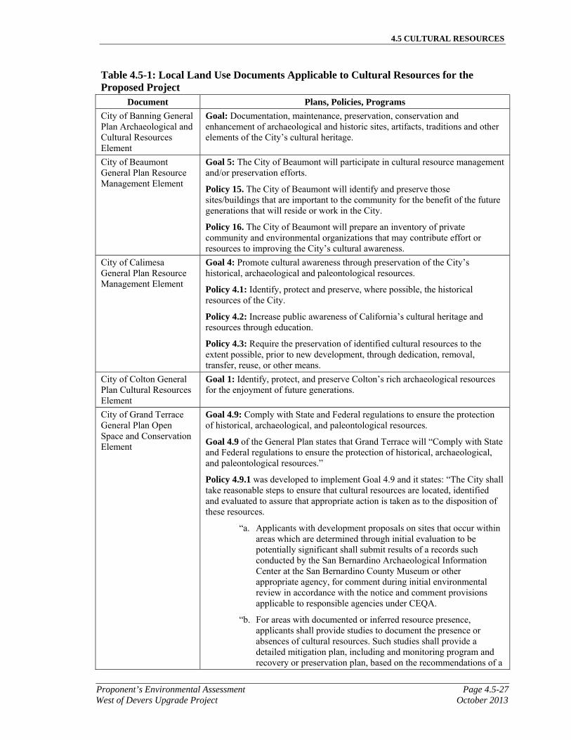
4.5 CULTURAL RESOURCES
Proponent’s Environmental Assessment Page 4.5-27West of Devers Upgrade Project October 2013
Table 4.5-1: Local Land Use Documents Applicable to Cultural Resources for the Proposed Project
Document Plans, Policies, Programs
City of Banning General Plan Archaeological and Cultural Resources Element
Goal: Documentation, maintenance, preservation, conservation and enhancement of archaeological and historic sites, artifacts, traditions and other elements of the City’s cultural heritage.
City of Beaumont General Plan Resource Management Element
Goal 5: The City of Beaumont will participate in cultural resource management and/or preservation efforts.
Policy 15. The City of Beaumont will identify and preserve those sites/buildings that are important to the community for the benefit of the future generations that will reside or work in the City.
Policy 16. The City of Beaumont will prepare an inventory of private community and environmental organizations that may contribute effort or resources to improving the City’s cultural awareness.
City of Calimesa General Plan Resource Management Element
Goal 4: Promote cultural awareness through preservation of the City’s historical, archaeological and paleontological resources.
Policy 4.1: Identify, protect and preserve, where possible, the historical resources of the City.
Policy 4.2: Increase public awareness of California’s cultural heritage and resources through education.
Policy 4.3: Require the preservation of identified cultural resources to the extent possible, prior to new development, through dedication, removal, transfer, reuse, or other means.
City of Colton General Plan Cultural Resources Element
Goal 1: Identify, protect, and preserve Colton’s rich archaeological resources for the enjoyment of future generations.
City of Grand Terrace General Plan Open Space and Conservation Element
Goal 4.9: Comply with State and Federal regulations to ensure the protection of historical, archaeological, and paleontological resources.
Goal 4.9 of the General Plan states that Grand Terrace will “Comply with State and Federal regulations to ensure the protection of historical, archaeological, and paleontological resources.”
Policy 4.9.1 was developed to implement Goal 4.9 and it states: “The City shall take reasonable steps to ensure that cultural resources are located, identified and evaluated to assure that appropriate action is taken as to the disposition of these resources.
“a. Applicants with development proposals on sites that occur within areas which are determined through initial evaluation to be potentially significant shall submit results of a records such conducted by the San Bernardino Archaeological Information Center at the San Bernardino County Museum or other appropriate agency, for comment during initial environmental review in accordance with the notice and comment provisions applicable to responsible agencies under CEQA.
“b. For areas with documented or inferred resource presence, applicants shall provide studies to document the presence or absences of cultural resources. Such studies shall provide a detailed mitigation plan, including and monitoring program and recovery or preservation plan, based on the recommendations of a
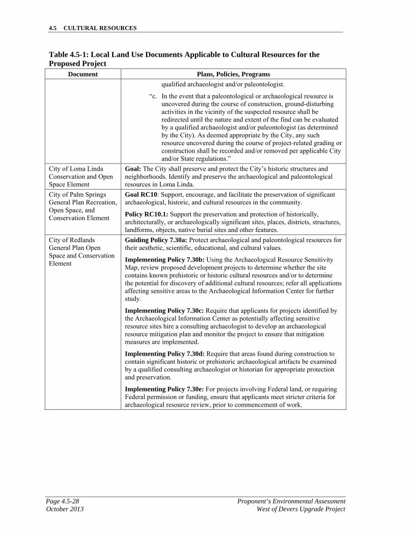
4.5 CULTURAL RESOURCES
Page 4.5-28 Proponent’s Environmental AssessmentOctober 2013 West of Devers Upgrade Project
Table 4.5-1: Local Land Use Documents Applicable to Cultural Resources for the Proposed Project
Document Plans, Policies, Programs
qualified archaeologist and/or paleontologist.
“c. In the event that a paleontological or archaeological resource is uncovered during the course of construction, ground-disturbing activities in the vicinity of the suspected resource shall be redirected until the nature and extent of the find can be evaluated by a qualified archaeologist and/or paleontologist (as determined by the City). As deemed appropriate by the City, any such resource uncovered during the course of project-related grading or construction shall be recorded and/or removed per applicable City and/or State regulations.”
City of Loma Linda Conservation and Open Space Element
Goal: The City shall preserve and protect the City’s historic structures and neighborhoods. Identify and preserve the archaeological and paleontological resources in Loma Linda.
City of Palm Springs General Plan Recreation, Open Space, and Conservation Element
Goal RC10: Support, encourage, and facilitate the preservation of significant archaeological, historic, and cultural resources in the community.
Policy RC10.1: Support the preservation and protection of historically, architecturally, or archaeologically significant sites, places, districts, structures, landforms, objects, native burial sites and other features.
City of Redlands General Plan Open Space and Conservation Element
Guiding Policy 7.30a: Protect archaeological and paleontological resources for their aesthetic, scientific, educational, and cultural values.
Implementing Policy 7.30b: Using the Archaeological Resource Sensitivity Map, review proposed development projects to determine whether the site contains known prehistoric or historic cultural resources and/or to determine the potential for discovery of additional cultural resources; refer all applications affecting sensitive areas to the Archaeological Information Center for further study.
Implementing Policy 7.30c: Require that applicants for projects identified by the Archaeological Information Center as potentially affecting sensitive resource sites hire a consulting archaeologist to develop an archaeological resource mitigation plan and monitor the project to ensure that mitigation measures are implemented.
Implementing Policy 7.30d: Require that areas found during construction to contain significant historic or prehistoric archaeological artifacts be examined by a qualified consulting archaeologist or historian for appropriate protection and preservation.
Implementing Policy 7.30e: For projects involving Federal land, or requiring Federal permission or funding, ensure that applicants meet stricter criteria for archaeological resource review, prior to commencement of work.
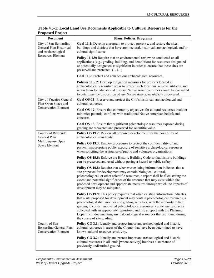
4.5 CULTURAL RESOURCES
Proponent’s Environmental Assessment Page 4.5-29West of Devers Upgrade Project October 2013
Table 4.5-1: Local Land Use Documents Applicable to Cultural Resources for the Proposed Project
Document Plans, Policies, Programs
City of San Bernardino General Plan Historical and Archaeological Resources Element
Goal 11.1: Develop a program to protect, preserve, and restore the sites, buildings and districts that have architectural, historical, archaeological, and/or cultural significance.
Policy 11.1.9: Require that an environmental review be conducted on all applications (e.g., grading, building, and demolition) for resources designated or potentially designated as significant in order to ensure that these sites are preserved and protected. (LU-1)
Goal 11.5: Protect and enhance our archaeological resources.
Policies 11.5.2: Develop mitigation measures for projects located in archaeologically sensitive areas to protect such locations, remove artifacts, and retain them for educational display. Native American tribes should be consulted to determine the disposition of any Native American artifacts discovered.
City of Yucaipa General Plan-Open Space and Conservation Element
Goal OS-11: Preserve and protect the City’s historical, archaeological and cultural resources.
Goal OS-12: Ensure that community objectives for cultural resources avoid or minimize potential conflicts with traditional Native American beliefs and concerns.
Goal OS-13: Ensure that significant paleontologic resources exposed during grading are recovered and preserved for scientific value.
County of Riverside General Plan Multipurpose Open Space Element
Policy OS 19.2: Review all proposed development for the possibility of archaeological sensitivity.
Policy OS 19.3: Employ procedures to protect the confidentiality of and prevent inappropriate public exposure of sensitive archaeological resources when soliciting the assistance of public and volunteer organizations.
Policy OS 19.6: Enforce the Historic Building Code so that historic buildings can be preserved and used without posing a hazard to public safety.
Policy OS 19.8: Require that whenever existing information indicates that a site proposed for development may contain biological, cultural, paleontological, or other scientific resources, a report shall be filed stating the extent and potential significance of the resource that may exist within the proposed development and appropriate measures through which the impacts of development may be mitigated.
Policy OS 19.9: This policy requires that when existing information indicates that a site proposed for development may contain paleontological resources, a paleontologist shall monitor site grading activities, with the authority to halt grading to collect uncovered paleontological resources, curate any resources collected with an appropriate repository, and file a report with the Planning Department documenting any paleontological resources that are found during the course of site grading.
County of San Bernardino General Plan Conservation Element
Policy CO 3.1: Identify and protect important archaeological and historic cultural resources in areas of the County that have been determined to have known cultural resource sensitivity.
Policy CO 3.2: Identify and protect important archaeological and historic cultural resources in all lands [where activity] involves disturbance of previously undisturbed ground.
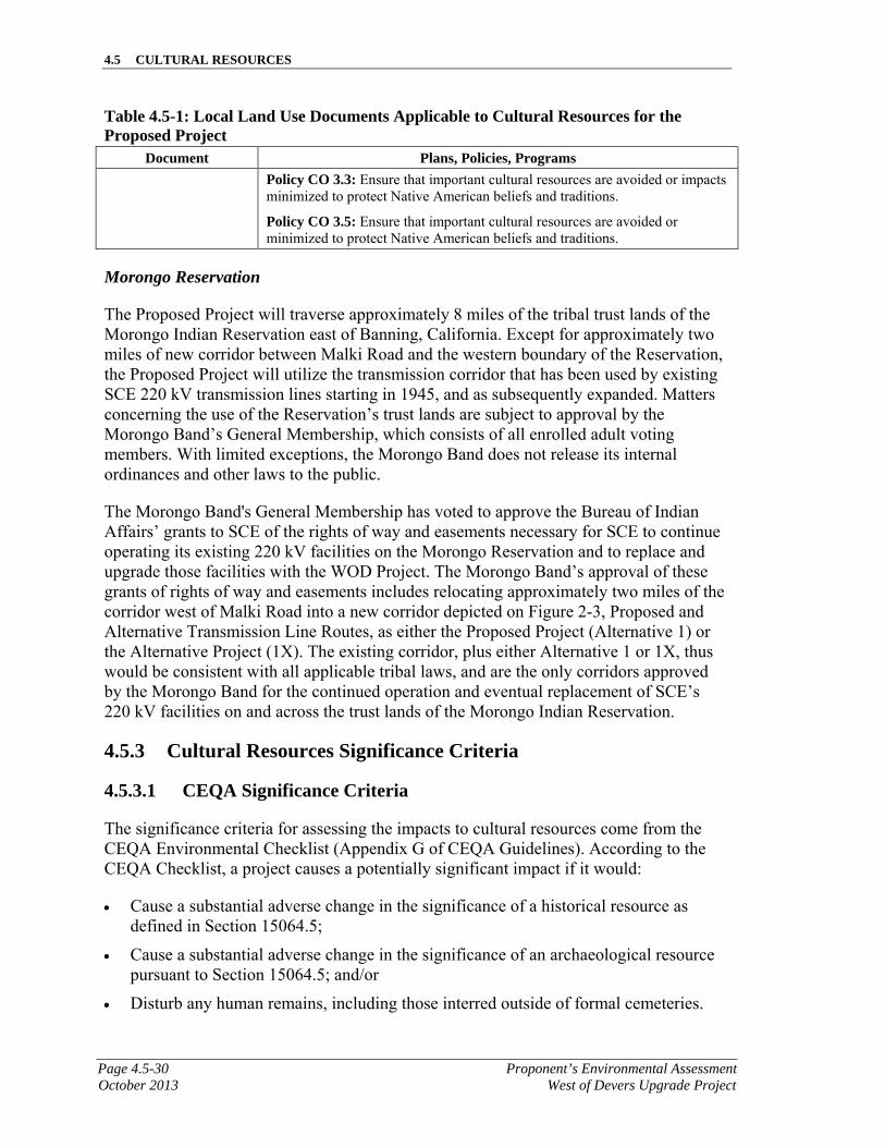
4.5 CULTURAL RESOURCES
Page 4.5-30 Proponent’s Environmental AssessmentOctober 2013 West of Devers Upgrade Project
Table 4.5-1: Local Land Use Documents Applicable to Cultural Resources for the Proposed Project
Document Plans, Policies, Programs
Policy CO 3.3: Ensure that important cultural resources are avoided or impacts minimized to protect Native American beliefs and traditions.
Policy CO 3.5: Ensure that important cultural resources are avoided or minimized to protect Native American beliefs and traditions.
Morongo Reservation
The Proposed Project will traverse approximately 8 miles of the tribal trust lands of the Morongo Indian Reservation east of Banning, California. Except for approximately two miles of new corridor between Malki Road and the western boundary of the Reservation, the Proposed Project will utilize the transmission corridor that has been used by existing SCE 220 kV transmission lines starting in 1945, and as subsequently expanded. Matters concerning the use of the Reservation’s trust lands are subject to approval by the Morongo Band’s General Membership, which consists of all enrolled adult voting members. With limited exceptions, the Morongo Band does not release its internal ordinances and other laws to the public.
The Morongo Band's General Membership has voted to approve the Bureau of Indian Affairs’ grants to SCE of the rights of way and easements necessary for SCE to continue operating its existing 220 kV facilities on the Morongo Reservation and to replace and upgrade those facilities with the WOD Project. The Morongo Band’s approval of these grants of rights of way and easements includes relocating approximately two miles of the corridor west of Malki Road into a new corridor depicted on Figure 2-3, Proposed and Alternative Transmission Line Routes, as either the Proposed Project (Alternative 1) or the Alternative Project (1X). The existing corridor, plus either Alternative 1 or 1X, thus would be consistent with all applicable tribal laws, and are the only corridors approved by the Morongo Band for the continued operation and eventual replacement of SCE’s 220 kV facilities on and across the trust lands of the Morongo Indian Reservation.
4.5.3 Cultural Resources Significance Criteria
4.5.3.1 CEQA Significance Criteria
The significance criteria for assessing the impacts to cultural resources come from the CEQA Environmental Checklist (Appendix G of CEQA Guidelines). According to the CEQA Checklist, a project causes a potentially significant impact if it would:
Cause a substantial adverse change in the significance of a historical resource as defined in Section 15064.5;
Cause a substantial adverse change in the significance of an archaeological resource pursuant to Section 15064.5; and/or
Disturb any human remains, including those interred outside of formal cemeteries.

4.5 CULTURAL RESOURCES
Proponent’s Environmental Assessment Page 4.5-31West of Devers Upgrade Project October 2013
State regulations affecting cultural resources include Public Resources Code Sections 21083.2 and 21084.1, and CEQA Guidelines Section 15064.5, and Appendix G. CEQA requires the lead agency to carefully consider the effects a project may have if it causes a substantial adverse change in the significance of a historic or archaeological resource.
Cultural resources as defined in CEQA include prehistoric and historic era archaeological sites, districts, and objects; historic buildings, structures, objects and districts; and traditional/cultural sites or the locations of important historic events. CEQA Guidelines Section 15064.5 states that a project may have a significant environmental effect if it causes a substantial adverse change in the significance of a historic resource. Additionally, the Lead Agency must consider properties eligible for listing on the CRHR or that are defined as a unique archaeological resource in Public Resources Code Section 21083.2.
4.5.3.2 NEPA Significance Criteria
Impact significance under NEPA is defined by the CEQ regulations and requires consideration of the temporal scale, spatial extent, and intensity of the change that would be introduced by the Proposed Action. To paraphrase 36 C.F.R. Part 800.8 (regulations implementing Section 106 of the NHPA), Coordination with the National Environmental Policy Act, Federal agencies are to coordinate compliance with Section 106 of the NHPA and the procedures in this part with any steps taken to meet the requirements of NEPA. Consulting parties and individuals who may be concerned with the possible effects of an agency action on historic properties should be prepared to consult early in the NEPA process. The determination of whether an undertaking is a “major Federal action significantly affecting the quality of the human environment” should include consideration of the undertaking’s likely effects on historic properties. According to 78 Fed. Reg. 38,223 (June 26, 2012). Protection of Historic Properties (Section 800.5):
An adverse effect is found when an undertaking may alter, directly or indirectly, any of the characteristics of a historic property that qualify the property for inclusion in the NRHP in a manner that would diminish the integrity of the property’s location, design, setting, materials, workmanship, feeling, or association. (36 C.F.R. § 800.5(a)(1) Criteria of Adverse effect)
4.5.4 Cultural Resources Impact Analysis
Records searches at the San Bernardino Archaeological Information Center (SBAIC) and Eastern Information Center (EIC) and archaeological survey of the APE/Project Study Area were conducted in 2012 and 2013. A total of 313 resources are located within the APE/Project Study Area based on the results of records searches and pedestrian surface surveys. One previously recorded water conveyance (P1074-85H) was not observed within the APE/Project Study Area while three previously recorded resources are no longer extant (P-33-15760, P-36-1134, and P-36-24295). Three previously recorded resources were relocated and determined not to be a cultural resource (P-33-13429, P-33-13430, and P-33-13433). Therefore, 306 cultural resources are confirmed as present within the APE/Project Study Area.
4.5 CULTURAL RESOURCES
Page 4.5-32 Proponent’s Environmental AssessmentOctober 2013 West of Devers Upgrade Project
The San Timoteo Canyon Schoolhouse (P-33-7292) is listed in the NRHP (No. 1646), and is located adjacent to the APE/Project Study Area along the telecommunications route through San Timoteo Canyon. Guachama Rancheria (P-36-2311/CA-SBR-2311H) is registered as a California Historical Landmark (No. 95), and is located within the APE/Project Study Area. The St. Boniface Indian School (CA-RIV-4213H) is a registered Point of Historical Interest (RIV-049) and located within the APE/Project Study Area. The Frink Adobe (P-36-10565), located on Mission Road in Loma Linda, is also a registered Point of Historical Interest (SBR-028).
Five major5 water conveyance systems are previously recorded within the APE/Project Study Area and include the Gage Canal (P-33-7168), Smith Creek Ditch (P-33-15033), a Pedley Type Dam (P-33-7870), Millard Canyon Stone Canal (P-33-14871), and the Colorado River Aqueduct (P-33-11265). The Colorado River Aqueduct (P-33-11265/CA-RIV-6726H) is recommended eligible for the NRHP; however, it does not daylight within the APE/Project Study Area and has not been the subject of consensus (formal) evaluation.
The Millard Canyon Stone Canal (P-33-14871) is a stone canal that served to convey water for the development in Cabazon in the 1880s. The canal is recommended as not eligible for the NRHP and is not eligible for the CRHR (Dice 2005). The APE/Project Study Area crosses this resource.
The Smith Creek Ditch (P-33-15033) is a channelized section of Smith Creek and includes check dams, foundations, footings, and access ramps in addition to steel pipe and culverts. The Smith Creek Ditch was likely used between 1880 and 1930 (Brunzell 2006). The resource is located along a portion of the APE/Project Study Area on the Reservation.
Seven previously recorded resources were not reidentified (re-located) or are not cultural resources. The historically mapped location of Camp Carleton Ditch (P1074-85H) is within the APE/Project Study Area, though the survey confirmed it is not located within the APE/Project Study Area. Marigold Farms (P-36-1134/CA-SBR-7139H) is no longer extant due to modern development. An isolated metate (P-33-15760) was collected by Morongo personnel and is no longer within the APE/Project Study Area. Isolated resources P-33-013429, P-33-013430, and P-33-013433 were determined to be non-artifactual. The historic Langford House (P-36-024295) has been demolished and is no longer extant.
No newly recorded resources are recommended as eligible for listing in the NRHP or CRHR at this time. A total of 26 resources may have sufficient potential to be eligible for listing, but require additional data to make a determination. Eight sites (P-33-11265/CA-RIV-6726H, P-36-6352, P-36-10565, P-36-13888, P-36-13891, P-36-19926, P-36-19927, and P-36-19929) were previously recommended as eligible for listing in the NRHP. One site was not relocated (P1074-85H). A total of 129 resources are recommended potentially ineligible for the NRHP or the CRHR. These resources consist of historical residences and tract homes from the 20th century and are not likely to meet any of the
5 A major water conveyance consists of a resource which was utilized exclusively for irrigation. It does not include
resources which have irrigation elements but are defined as another type of resource.

4.5 CULTURAL RESOURCES
Proponent’s Environmental Assessment Page 4.5-33West of Devers Upgrade Project October 2013
four criteria for eligibility, but added data are needed for formal evaluation. A total of 151resources are recommended ineligible for the NRHP or the CRHR. They fail to meet any of the four criteria, including association with a historic event or person, representation of important or artistic architecture, and potential to contribute important information (see Table 4.5-2, Description, Preliminary NRHP/CRHR Eligibility, Recommendations, and Impact Summary for Cultural Resources in the APE/Project Study Area). Fifty-five of these resources are isolates, which are, in all but exceptional cases, inherently ineligible for the NRHP or the CRHR. Forty of these resources consist of mid-20th century surficial trash scatters, consisting mainly of cans with limited diagnostic features. One sparse lithic scatter was determined ineligible, due to its poor integrity caused by recent grading. Seven resources do not qualify for the application of the four criteria because they are no longer extant, were not resources, or were not located; therefore, they are ineligible for listing. Forty-eight of these resources were historic-age structures, including residences, substations, transmission lines, water conveyance features, roads, and portions of railroads. These resources have been significantly altered since their period of significance and many are still in use. Their poor integrity limits their ability to contribute important information (Criterion D), and they do not meet the other three criteria.
Eight resources have the potential for significant subsurface archaeological deposits, although no surface artifacts were observed within the APE/Project Study Area and analysis of the pending final design may identify a need for subsurface testing to determine if any such deposits are present within the APE/Project Study Area. These resources are the Guachama Rancheria (P-36-2311/CA-SBR-2311), Singleton Ranch (P-33-7296), historic Native American village of Saahatpa (CA-RIV-179), and five prehistoric sites, located within the APE/Project Study Area (P-33-15992, P-33-16961, P-36-26047/CA-SBR-16502, P-33-22366/CA-RIV-11416, and P-33-22367/CA-RIV-11417). This may also apply to the San Timoteo Canyon Schoolhouse (P-33-7292), which is listed in the NRHP (No. 1646) and lies adjacent to the APE/Project Study Area along the telecommunications route.
Based on the observations from the survey and background research, the following general areas are considered culturally sensitive:
The foothills and area around Grand Terrace and the location of the bedrock milling features (LSA-SCE1110-S-PF-2): The presence of prehistoric bedrock milling stations can indicate a more substantial habitation area.
The location of the Guachama Rancheria: Although no surface evidence of the adobe or outlying structures or artifacts was observed during the survey of the APE/Project Study Area, the potential for subsurface historic deposits is high, as there is a significant history of the development of the area beginning in the early 19th century. This area is characterized by early Spanish settlement and the ethnohistoric Native American village of Guachama in the early 19th century, development in the early 20th century including the Van Uffelen diary, and residential expansion in the mid-20th century. The extant historic built environment is located adjacent to the existing WOD corridor in proposed temporary disturbance areas.
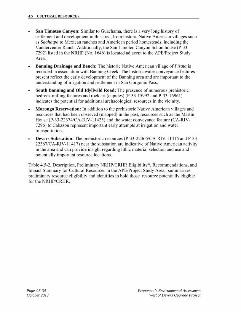
4.5 CULTURAL RESOURCES
Page 4.5-34 Proponent’s Environmental AssessmentOctober 2013 West of Devers Upgrade Project
San Timoteo Canyon: Similar to Guachama, there is a very long history of settlement and development in this area, from historic Native American villages such as Saahatpa to Mexican ranchos and American period homesteads, including the Vanderventer Ranch. Additionally, the San Timoteo Canyon Schoolhouse (P-33-7292) listed in the NRHP (No. 1646) is located adjacent to the APE/Project Study Area.
Banning Drainage and Bench: The historic Native American village of Pisata is recorded in association with Banning Creek. The historic water conveyance features present reflect the early development of the Banning area and are important to the understanding of irrigation and settlement in San Gorgonio Pass.
South Banning and Old Idyllwild Road: The presence of numerous prehistoric bedrock milling features and rock art (cupules) (P-33-15992 and P-33-16961) indicates the potential for additional archaeological resources in the vicinity.
Morongo Reservation: In addition to the prehistoric Native American villages and resources that had been observed (mapped) in the past, resources such as the Martin House (P-33-22374/CA-RIV-11425) and the water conveyance feature (CA-RIV-7296) to Cabazon represent important early attempts at irrigation and water transportation.
Devers Substation: The prehistoric resources (P-33-22366/CA-RIV-11416 and P-33-22367/CA-RIV-11417) near the substation are indicative of Native American activity in the area and can provide insight regarding lithic material selection and use and potentially important resource locations.
Table 4.5-2, Description, Preliminary NRHP/CRHR Eligibility*, Recommendations, and Impact Summary for Cultural Resources in the APE/Project Study Area, summarizes preliminary resource eligibility and identifies in bold those resource potentially eligible for the NRHP/CRHR.

4.5 CULTURAL RESOURCES
Proponent’s Environmental Assessment Page 4.5-35West of Devers Upgrade Project October 2013
Table 4.5-2: Description, Preliminary NRHP/CRHR Eligibility*, Recommendations, and Impact Summary for Cultural Resources in the APE/Project Study Area
Resource Description Preliminary NRHP/CRHR Eligibility Recommendations
Total Impact Acreage
Total No. Tower
Impacts
CA-RIV-179 Ethnohistoric Village of Saahatpa
This resource is potentially eligible for the CRHR and the NRHP, but added data are needed for a determination. It may be associated with an important historic event (Criterion A), a person significant to history (Criterion B), and has potential to contribute important information (Criterion D). The access road is within site boundary.
Avoid resource; if avoidance is not possible, the resource should be evaluated for eligibility.
— —
CA-RIV-1296 Lithic Scatter
Ineligible; this resource is not associated with an important event in history (Criterion A), a person significant to history (Criterion B), and lacks the potential to contribute important information (Criterion D). It does not have an architectural element, so Criterion C does not apply.
None 1.0 1
CA-RIV-2262H Vanderventer Ranch
This resource is potentially eligible for the CRHR and the NRHP, but added data are needed for a determination. It may have potential to contribute important information (Criterion D). No standing structures remain, so Criterion C does not apply.
Avoid resource; if avoidance is not possible, the resource should be evaluated for eligibility.
— —
CA-RIV-3446H** Historic Structures/Foundations; Historic Artifact Scatter
Ineligible; this resource is not associated with an important event in history (Criterion A) or a person significant to history (Criterion B). It does not represent the work of a master (Criterion C). It exhibits poor integrity and does not have potential to contribute important information (Criterion D).
None — —
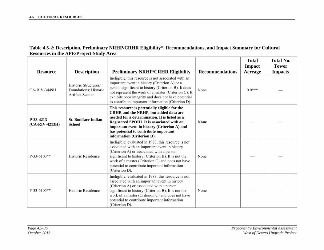
4.5 CULTURAL RESOURCES
Page 4.5-36 Proponent’s Environmental AssessmentOctober 2013 West of Devers Upgrade Project
Table 4.5-2: Description, Preliminary NRHP/CRHR Eligibility*, Recommendations, and Impact Summary for Cultural Resources in the APE/Project Study Area
Resource Description Preliminary NRHP/CRHR Eligibility Recommendations
Total Impact Acreage
Total No. Tower
Impacts
CA-RIV-3449H Historic Structures/Foundations; Historic Artifact Scatter
Ineligible; this resource is not associated with an important event in history (Criterion A) or a person significant to history (Criterion B). It does not represent the work of a master (Criterion C). It exhibits poor integrity and does not have potential to contribute important information (Criterion D).
None 0.0*** —
P-33-4213 (CA-RIV-4213H)
St. Boniface Indian School
This resource is potentially eligible for the CRHR and the NRHP, but added data are needed for a determination. It is listed as a Registered SPOHI. It is associated with an important event in history (Criterion A) and has potential to contribute important information (Criterion D).
None — —
P-33-6103** Historic Residence
Ineligible; evaluated in 1983, this resource is not associated with an important event in history (Criterion A) or associated with a person significant to history (Criterion B). It is not the work of a master (Criterion C) and does not have potential to contribute important information (Criterion D).
None — —
P-33-6105** Historic Residence
Ineligible; evaluated in 1983, this resource is not associated with an important event in history (Criterion A) or associated with a person significant to history (Criterion B). It is not the work of a master (Criterion C) and does not have potential to contribute important information (Criterion D).
None — —

4.5 CULTURAL RESOURCES
Proponent’s Environmental Assessment Page 4.5-37West of Devers Upgrade Project October 2013
Table 4.5-2: Description, Preliminary NRHP/CRHR Eligibility*, Recommendations, and Impact Summary for Cultural Resources in the APE/Project Study Area
Resource Description Preliminary NRHP/CRHR Eligibility Recommendations
Total Impact Acreage
Total No. Tower
Impacts
P-33-6107** Historic Residence
Ineligible; evaluated in 1983, this resource is not associated with an important event in history (Criterion A) or associated with a person significant to history (Criterion B). It is not the work of a master (Criterion C) and does not have potential to contribute important information (Criterion D).
None — —
P-33-6109** Historic Residence
Ineligible; evaluated in 1983, this resource is not associated with an important event in history (Criterion A) or associated with a person significant to history (Criterion B). It is not the work of a master (Criterion C) and does not have potential to contribute important information (Criterion D).
None — —
P-33-6156** Historic Residence
Ineligible; evaluated in 1983, this resource is not associated with an important event in history (Criterion A) or associated with a person significant to history (Criterion B). It is not the work of a master (Criterion C) and does not have potential to contribute important information (Criterion D).
None — —
P-33-6168** Historic Residence
Ineligible; evaluated in 1983, this resource is not associated with an important event in history (Criterion A) or associated with a person significant to history (Criterion B). It is not the work of a master (Criterion C) and does not have potential to contribute important information (Criterion D).
None — —
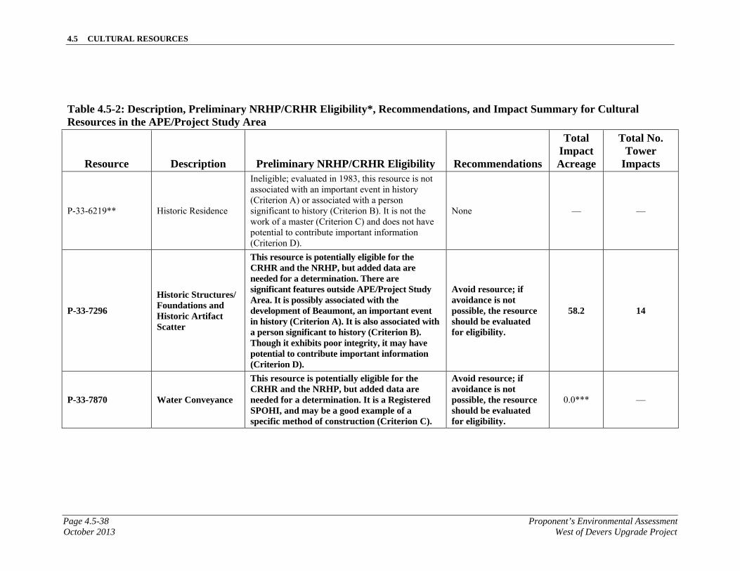
4.5 CULTURAL RESOURCES
Page 4.5-38 Proponent’s Environmental AssessmentOctober 2013 West of Devers Upgrade Project
Table 4.5-2: Description, Preliminary NRHP/CRHR Eligibility*, Recommendations, and Impact Summary for Cultural Resources in the APE/Project Study Area
Resource Description Preliminary NRHP/CRHR Eligibility Recommendations
Total Impact Acreage
Total No. Tower
Impacts
P-33-6219** Historic Residence
Ineligible; evaluated in 1983, this resource is not associated with an important event in history (Criterion A) or associated with a person significant to history (Criterion B). It is not the work of a master (Criterion C) and does not have potential to contribute important information (Criterion D).
None — —
P-33-7296
Historic Structures/Foundations and Historic Artifact Scatter
This resource is potentially eligible for the CRHR and the NRHP, but added data are needed for a determination. There are significant features outside APE/Project Study Area. It is possibly associated with the development of Beaumont, an important event in history (Criterion A). It is also associated with a person significant to history (Criterion B). Though it exhibits poor integrity, it may have potential to contribute important information (Criterion D).
Avoid resource; if avoidance is not possible, the resource should be evaluated for eligibility.
58.2 14
P-33-7870 Water Conveyance
This resource is potentially eligible for the CRHR and the NRHP, but added data are needed for a determination. It is a Registered SPOHI, and may be a good example of a specific method of construction (Criterion C).
Avoid resource; if avoidance is not possible, the resource should be evaluated for eligibility.
0.0*** —
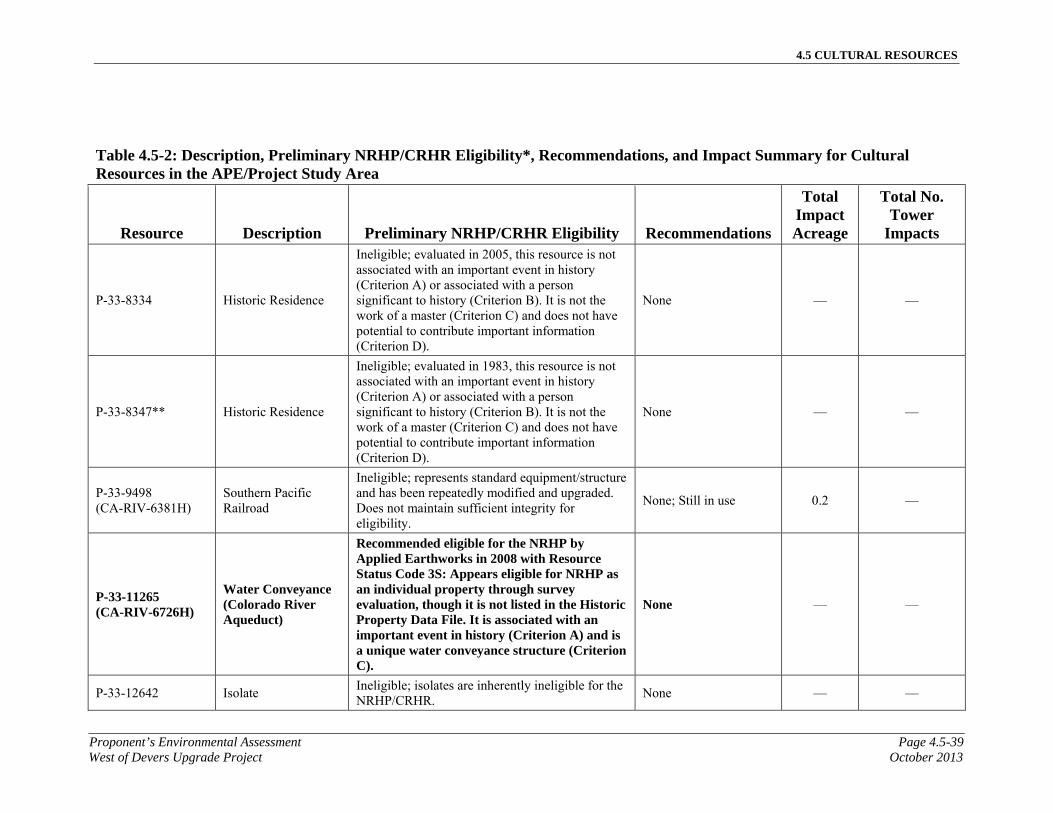
4.5 CULTURAL RESOURCES
Proponent’s Environmental Assessment Page 4.5-39West of Devers Upgrade Project October 2013
Table 4.5-2: Description, Preliminary NRHP/CRHR Eligibility*, Recommendations, and Impact Summary for Cultural Resources in the APE/Project Study Area
Resource Description Preliminary NRHP/CRHR Eligibility Recommendations
Total Impact Acreage
Total No. Tower
Impacts
P-33-8334 Historic Residence
Ineligible; evaluated in 2005, this resource is not associated with an important event in history (Criterion A) or associated with a person significant to history (Criterion B). It is not the work of a master (Criterion C) and does not have potential to contribute important information (Criterion D).
None — —
P-33-8347** Historic Residence
Ineligible; evaluated in 1983, this resource is not associated with an important event in history (Criterion A) or associated with a person significant to history (Criterion B). It is not the work of a master (Criterion C) and does not have potential to contribute important information (Criterion D).
None — —
P-33-9498 (CA-RIV-6381H)
Southern Pacific Railroad
Ineligible; represents standard equipment/structure and has been repeatedly modified and upgraded. Does not maintain sufficient integrity for eligibility.
None; Still in use 0.2 —
P-33-11265 (CA-RIV-6726H)
Water Conveyance (Colorado River Aqueduct)
Recommended eligible for the NRHP by Applied Earthworks in 2008 with Resource Status Code 3S: Appears eligible for NRHP as an individual property through survey evaluation, though it is not listed in the Historic Property Data File. It is associated with an important event in history (Criterion A) and is a unique water conveyance structure (Criterion C).
None — —
P-33-12642 Isolate Ineligible; isolates are inherently ineligible for the NRHP/CRHR.
None — —
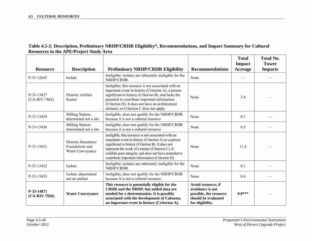
4.5 CULTURAL RESOURCES
Page 4.5-40 Proponent’s Environmental AssessmentOctober 2013 West of Devers Upgrade Project
Table 4.5-2: Description, Preliminary NRHP/CRHR Eligibility*, Recommendations, and Impact Summary for Cultural Resources in the APE/Project Study Area
Resource Description Preliminary NRHP/CRHR Eligibility Recommendations
Total Impact Acreage
Total No. Tower
Impacts
P-33-12643 Isolate Ineligible; isolates are inherently ineligible for the NRHP/CRHR.
None — —
P-33-13427 (CA-RIV-7462)
Historic Artifact Scatter
Ineligible; this resource is not associated with an important event in history (Criterion A), a person significant to history (Criterion B), and lacks the potential to contribute important information (Criterion D). It does not have an architectural element, so Criterion C does not apply.
None 3.4 —
P-33-13429 Milling Station; determined not a site
Ineligible; does not qualify for the NRHP/CRHR because it is not a cultural resource
None 0.1 —
P-33-13430 Milling Station; determined not a site
Ineligible; does not qualify for the NRHP/CRHR because it is not a cultural resource
None 0.5 —
P-33-13431 Historic Structures/Foundations and Water Conveyance
Ineligible; this resource is not associated with an important event in history (Criterion A) or a person significant to history (Criterion B). It does not represent the work of a master (Criterion C). It exhibits poor integrity and does not have potential to contribute important information (Criterion D).
None 11.6 —
P-33-13432 Isolate Ineligible; isolates are inherently ineligible for the NRHP/CRHR.
None 0.1 —
P-33-13433 Isolate; determined not an artifact
Ineligible; does not qualify for the NRHP/CRHR because it is not a cultural resource.
None 0.4 —
P-33-14871 (CA-RIV-7926)
Water Conveyance
This resource is potentially eligible for the CRHR and the NRHP, but added data are needed for a determination. It is possibly associated with the development of Cabazon, an important event in history (Criterion A).
Avoid resource; if avoidance is not possible, the resource should be evaluated for eligibility.
0.0*** —
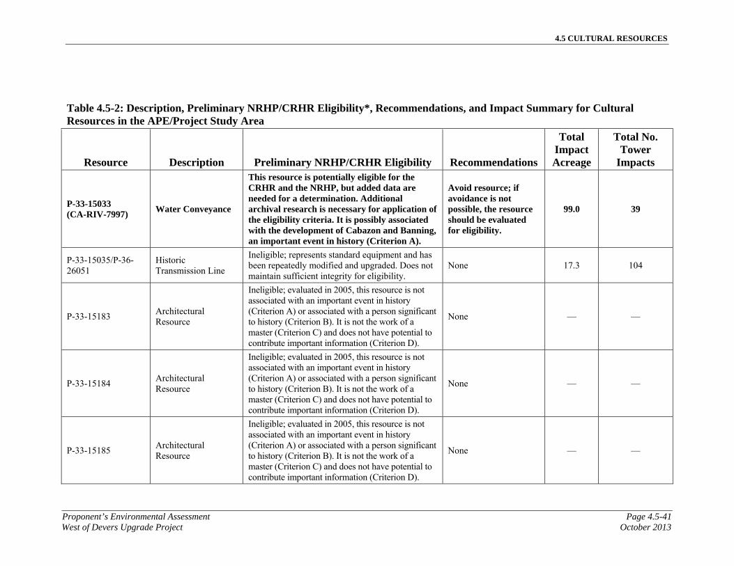
4.5 CULTURAL RESOURCES
Proponent’s Environmental Assessment Page 4.5-41West of Devers Upgrade Project October 2013
Table 4.5-2: Description, Preliminary NRHP/CRHR Eligibility*, Recommendations, and Impact Summary for Cultural Resources in the APE/Project Study Area
Resource Description Preliminary NRHP/CRHR Eligibility Recommendations
Total Impact Acreage
Total No. Tower
Impacts
P-33-15033 (CA-RIV-7997)
Water Conveyance
This resource is potentially eligible for the CRHR and the NRHP, but added data are needed for a determination. Additional archival research is necessary for application of the eligibility criteria. It is possibly associated with the development of Cabazon and Banning, an important event in history (Criterion A).
Avoid resource; if avoidance is not possible, the resource should be evaluated for eligibility.
99.0 39
P-33-15035/P-36-26051
Historic Transmission Line
Ineligible; represents standard equipment and has been repeatedly modified and upgraded. Does not maintain sufficient integrity for eligibility.
None 17.3 104
P-33-15183 Architectural Resource
Ineligible; evaluated in 2005, this resource is not associated with an important event in history (Criterion A) or associated with a person significant to history (Criterion B). It is not the work of a master (Criterion C) and does not have potential to contribute important information (Criterion D).
None — —
P-33-15184 Architectural Resource
Ineligible; evaluated in 2005, this resource is not associated with an important event in history (Criterion A) or associated with a person significant to history (Criterion B). It is not the work of a master (Criterion C) and does not have potential to contribute important information (Criterion D).
None — —
P-33-15185 Architectural Resource
Ineligible; evaluated in 2005, this resource is not associated with an important event in history (Criterion A) or associated with a person significant to history (Criterion B). It is not the work of a master (Criterion C) and does not have potential to contribute important information (Criterion D).
None — —
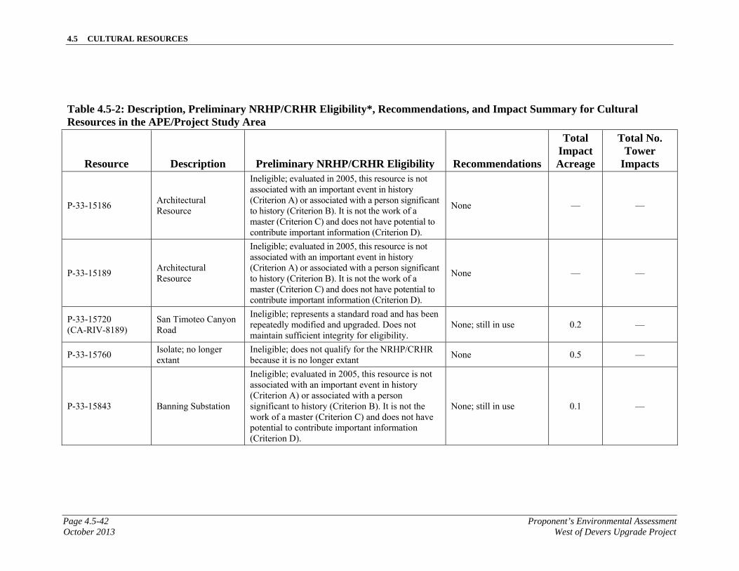
4.5 CULTURAL RESOURCES
Page 4.5-42 Proponent’s Environmental AssessmentOctober 2013 West of Devers Upgrade Project
Table 4.5-2: Description, Preliminary NRHP/CRHR Eligibility*, Recommendations, and Impact Summary for Cultural Resources in the APE/Project Study Area
Resource Description Preliminary NRHP/CRHR Eligibility Recommendations
Total Impact Acreage
Total No. Tower
Impacts
P-33-15186 Architectural Resource
Ineligible; evaluated in 2005, this resource is not associated with an important event in history (Criterion A) or associated with a person significant to history (Criterion B). It is not the work of a master (Criterion C) and does not have potential to contribute important information (Criterion D).
None — —
P-33-15189 Architectural Resource
Ineligible; evaluated in 2005, this resource is not associated with an important event in history (Criterion A) or associated with a person significant to history (Criterion B). It is not the work of a master (Criterion C) and does not have potential to contribute important information (Criterion D).
None — —
P-33-15720 (CA-RIV-8189)
San Timoteo Canyon Road
Ineligible; represents a standard road and has been repeatedly modified and upgraded. Does not maintain sufficient integrity for eligibility.
None; still in use 0.2 —
P-33-15760 Isolate; no longer extant
Ineligible; does not qualify for the NRHP/CRHR because it is no longer extant
None 0.5 —
P-33-15843 Banning Substation
Ineligible; evaluated in 2005, this resource is not associated with an important event in history (Criterion A) or associated with a person significant to history (Criterion B). It is not the work of a master (Criterion C) and does not have potential to contribute important information (Criterion D).
None; still in use 0.1 —
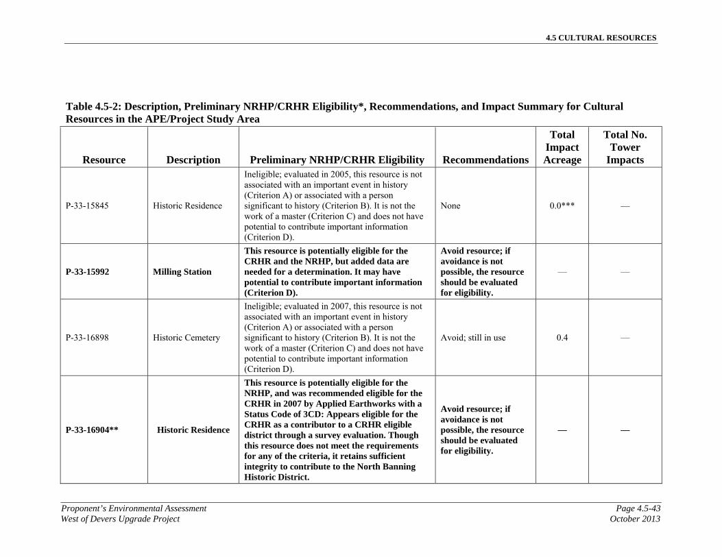
4.5 CULTURAL RESOURCES
Proponent’s Environmental Assessment Page 4.5-43West of Devers Upgrade Project October 2013
Table 4.5-2: Description, Preliminary NRHP/CRHR Eligibility*, Recommendations, and Impact Summary for Cultural Resources in the APE/Project Study Area
Resource Description Preliminary NRHP/CRHR Eligibility Recommendations
Total Impact Acreage
Total No. Tower
Impacts
P-33-15845 Historic Residence
Ineligible; evaluated in 2005, this resource is not associated with an important event in history (Criterion A) or associated with a person significant to history (Criterion B). It is not the work of a master (Criterion C) and does not have potential to contribute important information (Criterion D).
None 0.0*** —
P-33-15992 Milling Station
This resource is potentially eligible for the CRHR and the NRHP, but added data are needed for a determination. It may have potential to contribute important information (Criterion D).
Avoid resource; if avoidance is not possible, the resource should be evaluated for eligibility.
— —
P-33-16898 Historic Cemetery
Ineligible; evaluated in 2007, this resource is not associated with an important event in history (Criterion A) or associated with a person significant to history (Criterion B). It is not the work of a master (Criterion C) and does not have potential to contribute important information (Criterion D).
Avoid; still in use 0.4 —
P-33-16904** Historic Residence
This resource is potentially eligible for the NRHP, and was recommended eligible for the CRHR in 2007 by Applied Earthworks with a Status Code of 3CD: Appears eligible for the CRHR as a contributor to a CRHR eligible district through a survey evaluation. Though this resource does not meet the requirements for any of the criteria, it retains sufficient integrity to contribute to the North Banning Historic District.
Avoid resource; if avoidance is not possible, the resource should be evaluated for eligibility.
— —
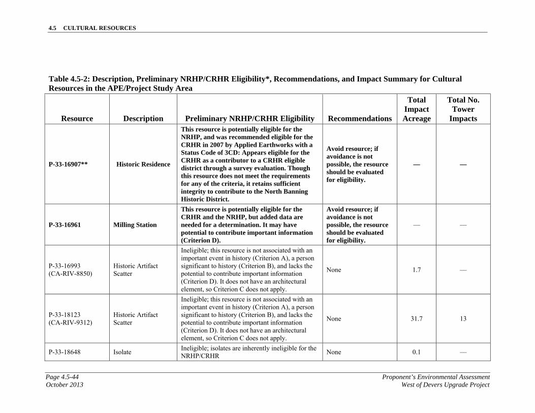
4.5 CULTURAL RESOURCES
Page 4.5-44 Proponent’s Environmental AssessmentOctober 2013 West of Devers Upgrade Project
Table 4.5-2: Description, Preliminary NRHP/CRHR Eligibility*, Recommendations, and Impact Summary for Cultural Resources in the APE/Project Study Area
Resource Description Preliminary NRHP/CRHR Eligibility Recommendations
Total Impact Acreage
Total No. Tower
Impacts
P-33-16907** Historic Residence
This resource is potentially eligible for the NRHP, and was recommended eligible for the CRHR in 2007 by Applied Earthworks with a Status Code of 3CD: Appears eligible for the CRHR as a contributor to a CRHR eligible district through a survey evaluation. Though this resource does not meet the requirements for any of the criteria, it retains sufficient integrity to contribute to the North Banning Historic District.
Avoid resource; if avoidance is not possible, the resource should be evaluated for eligibility.
— —
P-33-16961 Milling Station
This resource is potentially eligible for the CRHR and the NRHP, but added data are needed for a determination. It may have potential to contribute important information (Criterion D).
Avoid resource; if avoidance is not possible, the resource should be evaluated for eligibility.
— —
P-33-16993 (CA-RIV-8850)
Historic Artifact Scatter
Ineligible; this resource is not associated with an important event in history (Criterion A), a person significant to history (Criterion B), and lacks the potential to contribute important information (Criterion D). It does not have an architectural element, so Criterion C does not apply.
None 1.7 —
P-33-18123 (CA-RIV-9312)
Historic Artifact Scatter
Ineligible; this resource is not associated with an important event in history (Criterion A), a person significant to history (Criterion B), and lacks the potential to contribute important information (Criterion D). It does not have an architectural element, so Criterion C does not apply.
None 31.7 13
P-33-18648 Isolate Ineligible; isolates are inherently ineligible for the NRHP/CRHR
None 0.1 —
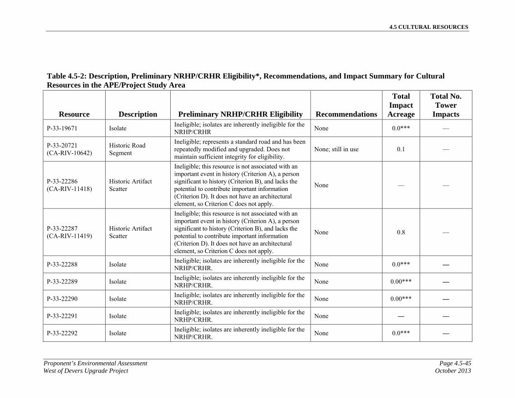
4.5 CULTURAL RESOURCES
Proponent’s Environmental Assessment Page 4.5-45West of Devers Upgrade Project October 2013
Table 4.5-2: Description, Preliminary NRHP/CRHR Eligibility*, Recommendations, and Impact Summary for Cultural Resources in the APE/Project Study Area
Resource Description Preliminary NRHP/CRHR Eligibility Recommendations
Total Impact Acreage
Total No. Tower
Impacts
P-33-19671 Isolate Ineligible; isolates are inherently ineligible for the NRHP/CRHR
None 0.0*** —
P-33-20721 (CA-RIV-10642)
Historic Road Segment
Ineligible; represents a standard road and has been repeatedly modified and upgraded. Does not maintain sufficient integrity for eligibility.
None; still in use 0.1 —
P-33-22286 (CA-RIV-11418)
Historic Artifact Scatter
Ineligible; this resource is not associated with an important event in history (Criterion A), a person significant to history (Criterion B), and lacks the potential to contribute important information (Criterion D). It does not have an architectural element, so Criterion C does not apply.
None — —
P-33-22287 (CA-RIV-11419)
Historic Artifact Scatter
Ineligible; this resource is not associated with an important event in history (Criterion A), a person significant to history (Criterion B), and lacks the potential to contribute important information (Criterion D). It does not have an architectural element, so Criterion C does not apply.
None 0.8 —
P-33-22288 Isolate Ineligible; isolates are inherently ineligible for the NRHP/CRHR.
None 0.0*** —
P-33-22289 Isolate Ineligible; isolates are inherently ineligible for the NRHP/CRHR.
None 0.00*** —
P-33-22290 Isolate Ineligible; isolates are inherently ineligible for the NRHP/CRHR.
None 0.00*** —
P-33-22291 Isolate Ineligible; isolates are inherently ineligible for the NRHP/CRHR.
None — —
P-33-22292 Isolate Ineligible; isolates are inherently ineligible for the NRHP/CRHR.
None 0.0*** —

4.5 CULTURAL RESOURCES
Page 4.5-46 Proponent’s Environmental AssessmentOctober 2013 West of Devers Upgrade Project
Table 4.5-2: Description, Preliminary NRHP/CRHR Eligibility*, Recommendations, and Impact Summary for Cultural Resources in the APE/Project Study Area
Resource Description Preliminary NRHP/CRHR Eligibility Recommendations
Total Impact Acreage
Total No. Tower
Impacts
P-33-22293 Isolate Ineligible; isolates are inherently ineligible for the NRHP/CRHR.
None — —
P-33-22294 Isolate Ineligible; isolates are inherently ineligible for the NRHP/CRHR.
None — —
P-33-22295 Isolate Ineligible; isolates are inherently ineligible for the NRHP/CRHR.
None — —
P-33-22296 Isolate Ineligible; isolates are inherently ineligible for the NRHP/CRHR.
None — —
P-33-22297 Isolate Ineligible; isolates are inherently ineligible for the NRHP/CRHR.
None — —
P-33-22305 Isolate Ineligible; isolates are inherently ineligible for the NRHP/CRHR.
None — —
P-33-22306 Isolate Ineligible; isolates are inherently ineligible for the NRHP/CRHR.
None 0.0*** —
P-33-22307 Isolate Ineligible; isolates are inherently ineligible for the NRHP/CRHR.
None 0.0*** —
P-33-22308 Isolate Ineligible; isolates are inherently ineligible for the NRHP/CRHR.
None 0.0*** —
P-33-22309 Isolate Ineligible; isolates are inherently ineligible for the NRHP/CRHR.
None 0.0*** —
P-33-22310 Isolate Ineligible; isolates are inherently ineligible for the NRHP/CRHR.
None 0.0*** —
P-33-22311 Isolate Ineligible; isolates are inherently ineligible for the NRHP/CRHR.
None 0.0*** —
P-33-22312 Isolate Ineligible; isolates are inherently ineligible for the NRHP/CRHR.
None — —
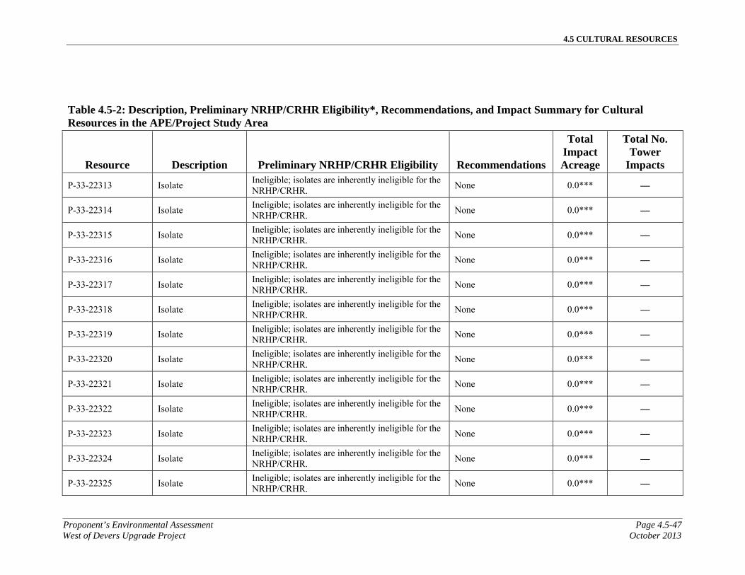
4.5 CULTURAL RESOURCES
Proponent’s Environmental Assessment Page 4.5-47West of Devers Upgrade Project October 2013
Table 4.5-2: Description, Preliminary NRHP/CRHR Eligibility*, Recommendations, and Impact Summary for Cultural Resources in the APE/Project Study Area
Resource Description Preliminary NRHP/CRHR Eligibility Recommendations
Total Impact Acreage
Total No. Tower
Impacts
P-33-22313 Isolate Ineligible; isolates are inherently ineligible for the NRHP/CRHR.
None 0.0*** —
P-33-22314 Isolate Ineligible; isolates are inherently ineligible for the NRHP/CRHR.
None 0.0*** —
P-33-22315 Isolate Ineligible; isolates are inherently ineligible for the NRHP/CRHR.
None 0.0*** —
P-33-22316 Isolate Ineligible; isolates are inherently ineligible for the NRHP/CRHR.
None 0.0*** —
P-33-22317 Isolate Ineligible; isolates are inherently ineligible for the NRHP/CRHR.
None 0.0*** —
P-33-22318 Isolate Ineligible; isolates are inherently ineligible for the NRHP/CRHR.
None 0.0*** —
P-33-22319 Isolate Ineligible; isolates are inherently ineligible for the NRHP/CRHR.
None 0.0*** —
P-33-22320 Isolate Ineligible; isolates are inherently ineligible for the NRHP/CRHR.
None 0.0*** —
P-33-22321 Isolate Ineligible; isolates are inherently ineligible for the NRHP/CRHR.
None 0.0*** —
P-33-22322 Isolate Ineligible; isolates are inherently ineligible for the NRHP/CRHR.
None 0.0*** —
P-33-22323 Isolate Ineligible; isolates are inherently ineligible for the NRHP/CRHR.
None 0.0*** —
P-33-22324 Isolate Ineligible; isolates are inherently ineligible for the NRHP/CRHR.
None 0.0*** —
P-33-22325 Isolate Ineligible; isolates are inherently ineligible for the NRHP/CRHR.
None 0.0*** —
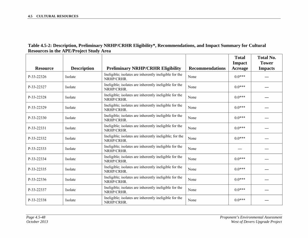
4.5 CULTURAL RESOURCES
Page 4.5-48 Proponent’s Environmental AssessmentOctober 2013 West of Devers Upgrade Project
Table 4.5-2: Description, Preliminary NRHP/CRHR Eligibility*, Recommendations, and Impact Summary for Cultural Resources in the APE/Project Study Area
Resource Description Preliminary NRHP/CRHR Eligibility Recommendations
Total Impact Acreage
Total No. Tower
Impacts
P-33-22326 Isolate Ineligible; isolates are inherently ineligible for the NRHP/CRHR.
None 0.0*** —
P-33-22327 Isolate Ineligible; isolates are inherently ineligible for the NRHP/CRHR.
None 0.0*** —
P-33-22328 Isolate Ineligible; isolates are inherently ineligible for the NRHP/CRHR.
None 0.0*** —
P-33-22329 Isolate Ineligible; isolates are inherently ineligible for the NRHP/CRHR.
None 0.0*** —
P-33-22330 Isolate Ineligible; isolates are inherently ineligible for the NRHP/CRHR.
None 0.0*** —
P-33-22331 Isolate Ineligible; isolates are inherently ineligible for the NRHP/CRHR.
None 0.0*** —
P-33-22332 Isolate Ineligible; isolates are inherently ineligible; for the NRHP/CRHR.
None 0.0*** —
P-33-22333 Isolate Ineligible; isolates are inherently ineligible for the NRHP/CRHR.
None — —
P-33-22334 Isolate Ineligible; isolates are inherently ineligible for the NRHP/CRHR.
None 0.0*** —
P-33-22335 Isolate Ineligible; isolates are inherently ineligible for the NRHP/CRHR.
None 0.0*** —
P-33-22336 Isolate Ineligible; isolates are inherently ineligible for the NRHP/CRHR.
None 0.0*** —
P-33-22337 Isolate Ineligible; isolates are inherently ineligible for the NRHP/CRHR.
None 0.0*** —
P-33-22338 Isolate Ineligible; isolates are inherently ineligible for the NRHP/CRHR.
None 0.0*** —

4.5 CULTURAL RESOURCES
Proponent’s Environmental Assessment Page 4.5-49West of Devers Upgrade Project October 2013
Table 4.5-2: Description, Preliminary NRHP/CRHR Eligibility*, Recommendations, and Impact Summary for Cultural Resources in the APE/Project Study Area
Resource Description Preliminary NRHP/CRHR Eligibility Recommendations
Total Impact Acreage
Total No. Tower
Impacts
P-33-22339 Isolate Ineligible; isolates are inherently ineligible for the NRHP/CRHR.
None 0.0*** —
P-33-22340 Isolate Ineligible; isolates are inherently ineligible for the NRHP/CRHR.
None 0.0*** —
P-33-22341 Isolate Ineligible; isolates are inherently ineligible for the NRHP/CRHR.
None 0.0*** —
P-33-22342 Isolate Ineligible; isolates are inherently ineligible for the NRHP/CRHR.
None 0.0*** —
P-33-22343 Isolate Ineligible; isolates are inherently ineligible for the NRHP/CRHR.
None 0.0*** —
P-33-22344 Water Conveyance
Ineligible; this resource is not associated with an important event in history (Criterion A) or a person significant to history (Criterion B). It does not represent the work of a master (Criterion C). It exhibits poor integrity and does not have potential to contribute important information (Criterion D).
None 0.0*** —
P-33-22345 (CA-RIV-11395)
Water Conveyance
This resource is potentially eligible for the CRHR and the NRHP, but added data are needed for a determination. Additional archival research is necessary to allow application of the eligibility criteria. Possibly significant locally. It exhibits fair integrity and may be associated with the development of Banning, an important event in history (Criterion A).
Avoid resource; if avoidance is not possible, the resource should be evaluated for eligibility.
0.0*** —
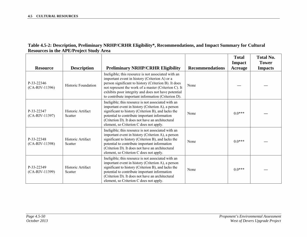
4.5 CULTURAL RESOURCES
Page 4.5-50 Proponent’s Environmental AssessmentOctober 2013 West of Devers Upgrade Project
Table 4.5-2: Description, Preliminary NRHP/CRHR Eligibility*, Recommendations, and Impact Summary for Cultural Resources in the APE/Project Study Area
Resource Description Preliminary NRHP/CRHR Eligibility Recommendations
Total Impact Acreage
Total No. Tower
Impacts
P-33-22346 (CA-RIV-11396)
Historic Foundation
Ineligible; this resource is not associated with an important event in history (Criterion A) or a person significant to history (Criterion B). It does not represent the work of a master (Criterion C). It exhibits poor integrity and does not have potential to contribute important information (Criterion D).
None — —
P-33-22347 (CA-RIV-11397)
Historic Artifact Scatter
Ineligible; this resource is not associated with an important event in history (Criterion A), a person significant to history (Criterion B), and lacks the potential to contribute important information (Criterion D). It does not have an architectural element, so Criterion C does not apply.
None 0.0*** —
P-33-22348 (CA-RIV-11398)
Historic Artifact Scatter
Ineligible; this resource is not associated with an important event in history (Criterion A), a person significant to history (Criterion B), and lacks the potential to contribute important information (Criterion D). It does not have an architectural element, so Criterion C does not apply.
None 0.0*** —
P-33-22349 (CA-RIV-11399)
Historic Artifact Scatter
Ineligible; this resource is not associated with an important event in history (Criterion A), a person significant to history (Criterion B), and lacks the potential to contribute important information (Criterion D). It does not have an architectural element, so Criterion C does not apply.
None 0.0*** —
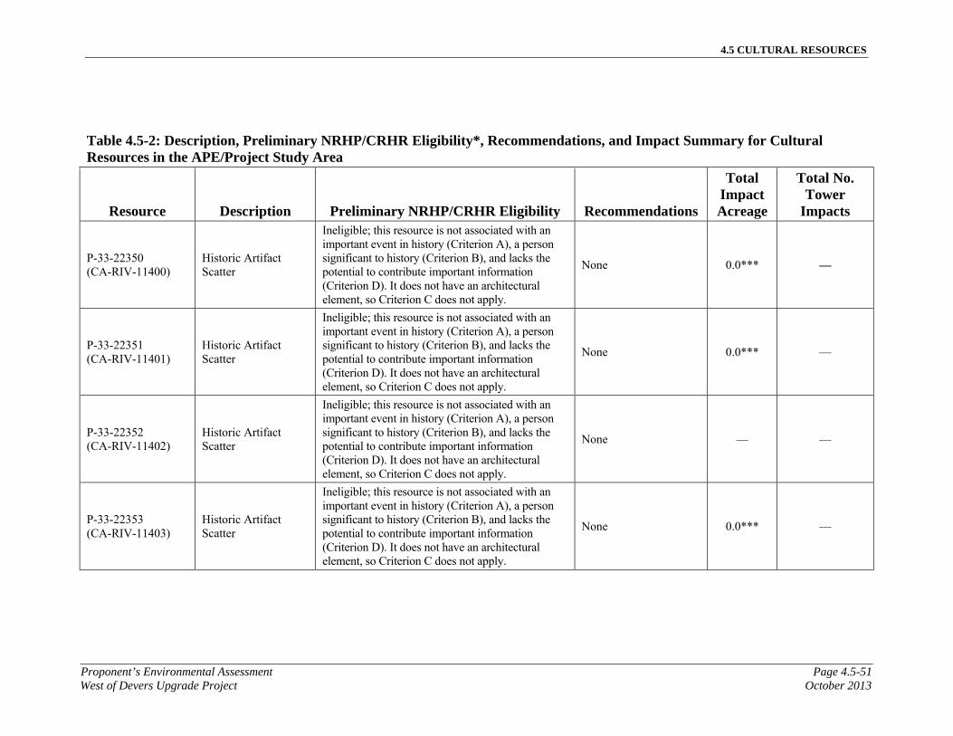
4.5 CULTURAL RESOURCES
Proponent’s Environmental Assessment Page 4.5-51West of Devers Upgrade Project October 2013
Table 4.5-2: Description, Preliminary NRHP/CRHR Eligibility*, Recommendations, and Impact Summary for Cultural Resources in the APE/Project Study Area
Resource Description Preliminary NRHP/CRHR Eligibility Recommendations
Total Impact Acreage
Total No. Tower
Impacts
P-33-22350 (CA-RIV-11400)
Historic Artifact Scatter
Ineligible; this resource is not associated with an important event in history (Criterion A), a person significant to history (Criterion B), and lacks the potential to contribute important information (Criterion D). It does not have an architectural element, so Criterion C does not apply.
None 0.0*** —
P-33-22351 (CA-RIV-11401)
Historic Artifact Scatter
Ineligible; this resource is not associated with an important event in history (Criterion A), a person significant to history (Criterion B), and lacks the potential to contribute important information (Criterion D). It does not have an architectural element, so Criterion C does not apply.
None 0.0*** —
P-33-22352 (CA-RIV-11402)
Historic Artifact Scatter
Ineligible; this resource is not associated with an important event in history (Criterion A), a person significant to history (Criterion B), and lacks the potential to contribute important information (Criterion D). It does not have an architectural element, so Criterion C does not apply.
None — —
P-33-22353 (CA-RIV-11403)
Historic Artifact Scatter
Ineligible; this resource is not associated with an important event in history (Criterion A), a person significant to history (Criterion B), and lacks the potential to contribute important information (Criterion D). It does not have an architectural element, so Criterion C does not apply.
None 0.0*** —

4.5 CULTURAL RESOURCES
Page 4.5-52 Proponent’s Environmental AssessmentOctober 2013 West of Devers Upgrade Project
Table 4.5-2: Description, Preliminary NRHP/CRHR Eligibility*, Recommendations, and Impact Summary for Cultural Resources in the APE/Project Study Area
Resource Description Preliminary NRHP/CRHR Eligibility Recommendations
Total Impact Acreage
Total No. Tower
Impacts
P-33-22354 (CA-RIV-11404)
Historic Artifact Scatter
Ineligible; this resource is not associated with an important event in history (Criterion A), a person significant to history (Criterion B), and lacks the potential to contribute important information (Criterion D). It does not have an architectural element, so Criterion C does not apply.
None 0.1 —
P-33-22355 (CA-RIV-11405)
Historic Artifact Scatter
Ineligible; this resource is not associated with an important event in history (Criterion A), a person significant to history (Criterion B), and lacks the potential to contribute important information (Criterion D). It does not have an architectural element, so Criterion C does not apply.
None 0.0*** —
P-33-22356 (CA-RIV-11406)
Historic Artifact Scatter
Ineligible; this resource is not associated with an important event in history (Criterion A), a person significant to history (Criterion B), and lacks the potential to contribute important information (Criterion D). It does not have an architectural element, so Criterion C does not apply.
None 0.0*** —
P-33-22357 (CA-RIV-11407)
Historic Artifact Scatter
Ineligible; this resource is not associated with an important event in history (Criterion A), a person significant to history (Criterion B), and lacks the potential to contribute important information (Criterion D). It does not have an architectural element, so Criterion C does not apply.
None 0.0*** —
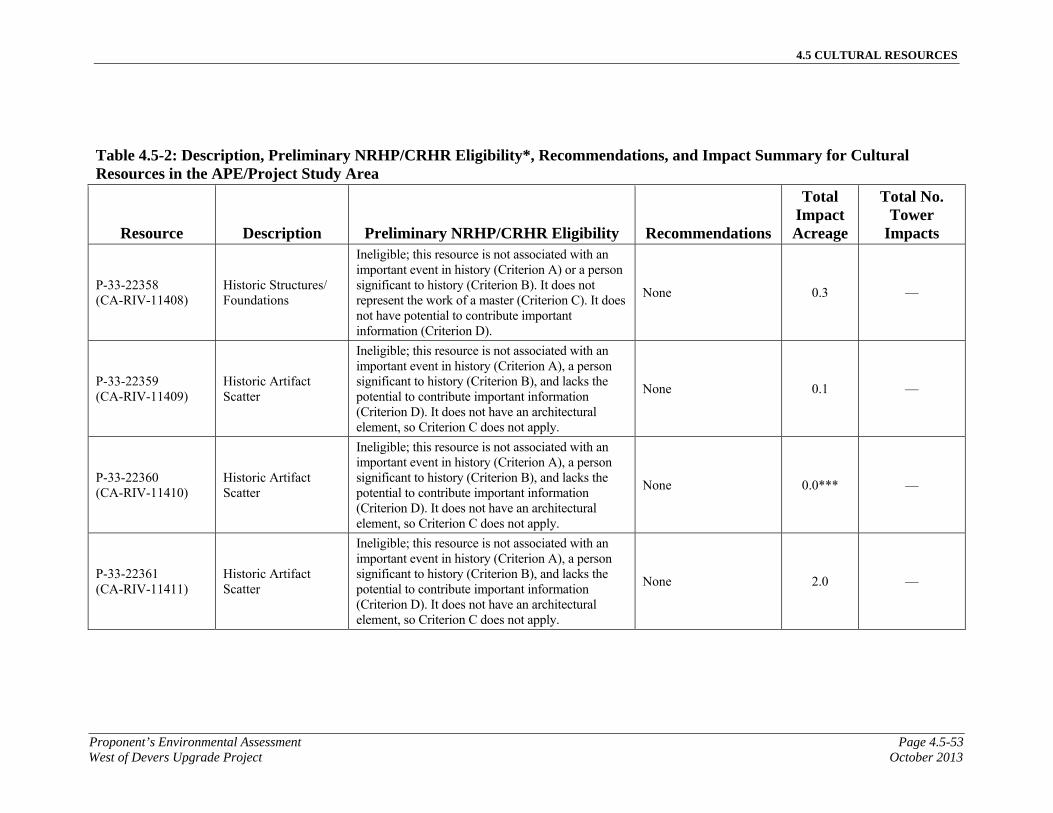
4.5 CULTURAL RESOURCES
Proponent’s Environmental Assessment Page 4.5-53West of Devers Upgrade Project October 2013
Table 4.5-2: Description, Preliminary NRHP/CRHR Eligibility*, Recommendations, and Impact Summary for Cultural Resources in the APE/Project Study Area
Resource Description Preliminary NRHP/CRHR Eligibility Recommendations
Total Impact Acreage
Total No. Tower
Impacts
P-33-22358 (CA-RIV-11408)
Historic Structures/Foundations
Ineligible; this resource is not associated with an important event in history (Criterion A) or a person significant to history (Criterion B). It does not represent the work of a master (Criterion C). It does not have potential to contribute important information (Criterion D).
None 0.3 —
P-33-22359 (CA-RIV-11409)
Historic Artifact Scatter
Ineligible; this resource is not associated with an important event in history (Criterion A), a person significant to history (Criterion B), and lacks the potential to contribute important information (Criterion D). It does not have an architectural element, so Criterion C does not apply.
None 0.1 —
P-33-22360 (CA-RIV-11410)
Historic Artifact Scatter
Ineligible; this resource is not associated with an important event in history (Criterion A), a person significant to history (Criterion B), and lacks the potential to contribute important information (Criterion D). It does not have an architectural element, so Criterion C does not apply.
None 0.0*** —
P-33-22361 (CA-RIV-11411)
Historic Artifact Scatter
Ineligible; this resource is not associated with an important event in history (Criterion A), a person significant to history (Criterion B), and lacks the potential to contribute important information (Criterion D). It does not have an architectural element, so Criterion C does not apply.
None 2.0 —

4.5 CULTURAL RESOURCES
Page 4.5-54 Proponent’s Environmental AssessmentOctober 2013 West of Devers Upgrade Project
Table 4.5-2: Description, Preliminary NRHP/CRHR Eligibility*, Recommendations, and Impact Summary for Cultural Resources in the APE/Project Study Area
Resource Description Preliminary NRHP/CRHR Eligibility Recommendations
Total Impact Acreage
Total No. Tower
Impacts
P-33-22362 (CA-RIV-11412)
Historic Artifact Scatter
Ineligible; this resource is not associated with an important event in history (Criterion A), a person significant to history (Criterion B), and lacks the potential to contribute important information (Criterion D). It does not have an architectural element, so Criterion C does not apply.
None 0.9 1
P-33-22363 (CA-RIV-11413)
Historic Artifact Scatter
Ineligible; this resource is not associated with an important event in history (Criterion A), a person significant to history (Criterion B), and lacks the potential to contribute important information (Criterion D). It does not have an architectural element, so Criterion C does not apply.
None 0.0*** —
P-33-22364 (CA-RIV-11414)
Historic Artifact Scatter
Ineligible; this resource is not associated with an important event in history (Criterion A), a person significant to history (Criterion B), and lacks the potential to contribute important information (Criterion D). It does not have an architectural element, so Criterion C does not apply.
None 0.0*** —
P-33-22365 (CA-RIV-11415)
Historic Artifact Scatter
Ineligible; this resource is not associated with an important event in history (Criterion A), a person significant to history (Criterion B), and lacks the potential to contribute important information (Criterion D). It does not have an architectural element, so Criterion C does not apply.
None 0.3 —
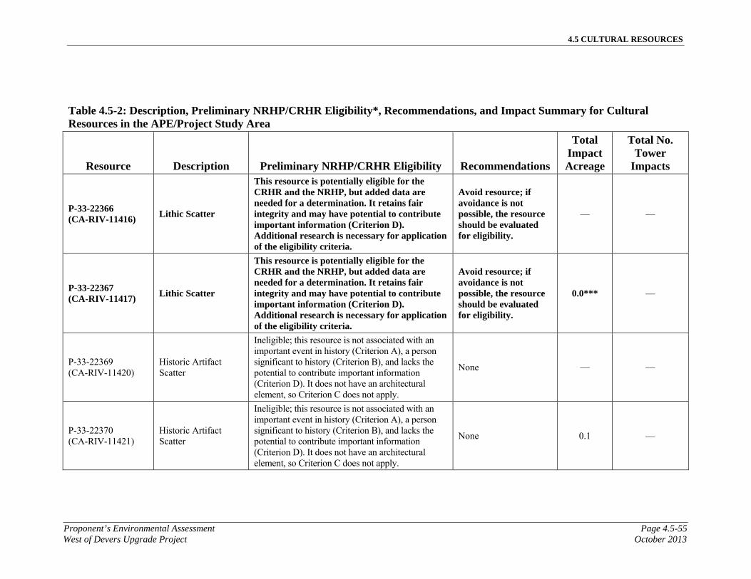
4.5 CULTURAL RESOURCES
Proponent’s Environmental Assessment Page 4.5-55West of Devers Upgrade Project October 2013
Table 4.5-2: Description, Preliminary NRHP/CRHR Eligibility*, Recommendations, and Impact Summary for Cultural Resources in the APE/Project Study Area
Resource Description Preliminary NRHP/CRHR Eligibility Recommendations
Total Impact Acreage
Total No. Tower
Impacts
P-33-22366 (CA-RIV-11416)
Lithic Scatter
This resource is potentially eligible for the CRHR and the NRHP, but added data are needed for a determination. It retains fair integrity and may have potential to contribute important information (Criterion D). Additional research is necessary for application of the eligibility criteria.
Avoid resource; if avoidance is not possible, the resource should be evaluated for eligibility.
— —
P-33-22367 (CA-RIV-11417)
Lithic Scatter
This resource is potentially eligible for the CRHR and the NRHP, but added data are needed for a determination. It retains fair integrity and may have potential to contribute important information (Criterion D). Additional research is necessary for application of the eligibility criteria.
Avoid resource; if avoidance is not possible, the resource should be evaluated for eligibility.
0.0*** —
P-33-22369 (CA-RIV-11420)
Historic Artifact Scatter
Ineligible; this resource is not associated with an important event in history (Criterion A), a person significant to history (Criterion B), and lacks the potential to contribute important information (Criterion D). It does not have an architectural element, so Criterion C does not apply.
None — —
P-33-22370 (CA-RIV-11421)
Historic Artifact Scatter
Ineligible; this resource is not associated with an important event in history (Criterion A), a person significant to history (Criterion B), and lacks the potential to contribute important information (Criterion D). It does not have an architectural element, so Criterion C does not apply.
None 0.1 —
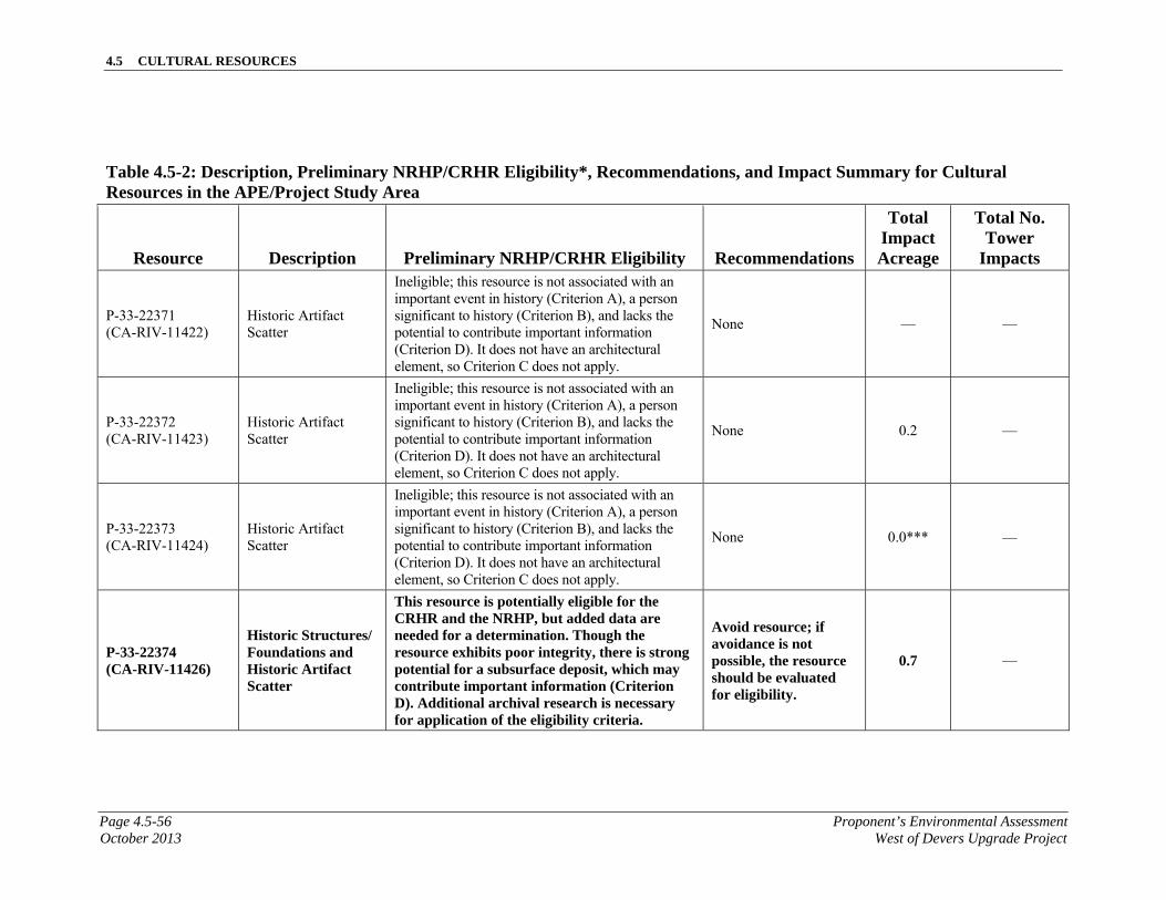
4.5 CULTURAL RESOURCES
Page 4.5-56 Proponent’s Environmental AssessmentOctober 2013 West of Devers Upgrade Project
Table 4.5-2: Description, Preliminary NRHP/CRHR Eligibility*, Recommendations, and Impact Summary for Cultural Resources in the APE/Project Study Area
Resource Description Preliminary NRHP/CRHR Eligibility Recommendations
Total Impact Acreage
Total No. Tower
Impacts
P-33-22371 (CA-RIV-11422)
Historic Artifact Scatter
Ineligible; this resource is not associated with an important event in history (Criterion A), a person significant to history (Criterion B), and lacks the potential to contribute important information (Criterion D). It does not have an architectural element, so Criterion C does not apply.
None — —
P-33-22372 (CA-RIV-11423)
Historic Artifact Scatter
Ineligible; this resource is not associated with an important event in history (Criterion A), a person significant to history (Criterion B), and lacks the potential to contribute important information (Criterion D). It does not have an architectural element, so Criterion C does not apply.
None 0.2 —
P-33-22373 (CA-RIV-11424)
Historic Artifact Scatter
Ineligible; this resource is not associated with an important event in history (Criterion A), a person significant to history (Criterion B), and lacks the potential to contribute important information (Criterion D). It does not have an architectural element, so Criterion C does not apply.
None 0.0*** —
P-33-22374 (CA-RIV-11426)
Historic Structures/Foundations and Historic Artifact Scatter
This resource is potentially eligible for the CRHR and the NRHP, but added data are needed for a determination. Though the resource exhibits poor integrity, there is strong potential for a subsurface deposit, which may contribute important information (Criterion D). Additional archival research is necessary for application of the eligibility criteria.
Avoid resource; if avoidance is not possible, the resource should be evaluated for eligibility.
0.7 —

4.5 CULTURAL RESOURCES
Proponent’s Environmental Assessment Page 4.5-57West of Devers Upgrade Project October 2013
Table 4.5-2: Description, Preliminary NRHP/CRHR Eligibility*, Recommendations, and Impact Summary for Cultural Resources in the APE/Project Study Area
Resource Description Preliminary NRHP/CRHR Eligibility Recommendations
Total Impact Acreage
Total No. Tower
Impacts
P-33-22375 (CA-RIV-11427)
Historic Artifact Scatter
Ineligible; this resource is not associated with an important event in history (Criterion A), a person significant to history (Criterion B), and lacks the potential to contribute important information (Criterion D). It does not have an architectural element, so Criterion C does not apply.
None 0.1 —
P-33-22376 (CA-RIV-11428)
Historic Structures/Foundations and Historic Artifact Scatter
Ineligible; this resource is not associated with an important event in history (Criterion A) or a person significant to history (Criterion B). It does not represent the work of a master (Criterion C). It exhibits poor integrity and does not have potential to contribute important information (Criterion D).
None — —
P-33-22378 (CA-RIV-11430)
Historic Artifact Scatter
Ineligible; this resource is not associated with an important event in history (Criterion A), a person significant to history (Criterion B), and lacks the potential to contribute important information (Criterion D). It does not have an architectural element, so Criterion C does not apply.
None 0.1 —
P-33-22379 (CA-RIV-11431)
Historic Artifact Scatter
Ineligible; this resource is not associated with an important event in history (Criterion A), a person significant to history (Criterion B), and lacks the potential to contribute important information (Criterion D). It does not have an architectural element, so Criterion C does not apply.
None 0.1 —
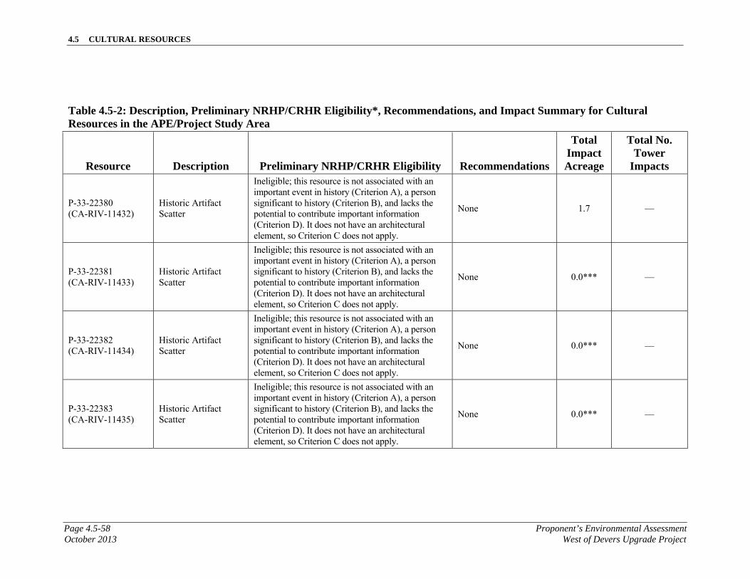
4.5 CULTURAL RESOURCES
Page 4.5-58 Proponent’s Environmental AssessmentOctober 2013 West of Devers Upgrade Project
Table 4.5-2: Description, Preliminary NRHP/CRHR Eligibility*, Recommendations, and Impact Summary for Cultural Resources in the APE/Project Study Area
Resource Description Preliminary NRHP/CRHR Eligibility Recommendations
Total Impact Acreage
Total No. Tower
Impacts
P-33-22380 (CA-RIV-11432)
Historic Artifact Scatter
Ineligible; this resource is not associated with an important event in history (Criterion A), a person significant to history (Criterion B), and lacks the potential to contribute important information (Criterion D). It does not have an architectural element, so Criterion C does not apply.
None 1.7 —
P-33-22381 (CA-RIV-11433)
Historic Artifact Scatter
Ineligible; this resource is not associated with an important event in history (Criterion A), a person significant to history (Criterion B), and lacks the potential to contribute important information (Criterion D). It does not have an architectural element, so Criterion C does not apply.
None 0.0*** —
P-33-22382 (CA-RIV-11434)
Historic Artifact Scatter
Ineligible; this resource is not associated with an important event in history (Criterion A), a person significant to history (Criterion B), and lacks the potential to contribute important information (Criterion D). It does not have an architectural element, so Criterion C does not apply.
None 0.0*** —
P-33-22383 (CA-RIV-11435)
Historic Artifact Scatter
Ineligible; this resource is not associated with an important event in history (Criterion A), a person significant to history (Criterion B), and lacks the potential to contribute important information (Criterion D). It does not have an architectural element, so Criterion C does not apply.
None 0.0*** —
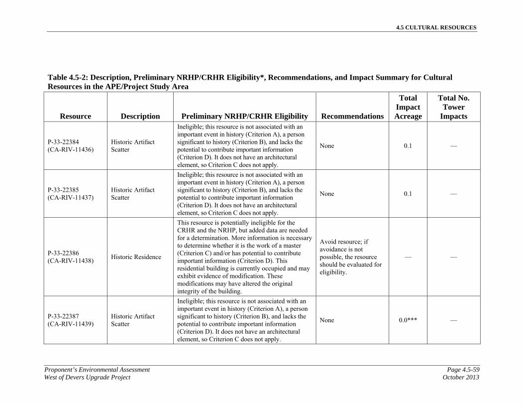
4.5 CULTURAL RESOURCES
Proponent’s Environmental Assessment Page 4.5-59West of Devers Upgrade Project October 2013
Table 4.5-2: Description, Preliminary NRHP/CRHR Eligibility*, Recommendations, and Impact Summary for Cultural Resources in the APE/Project Study Area
Resource Description Preliminary NRHP/CRHR Eligibility Recommendations
Total Impact Acreage
Total No. Tower
Impacts
P-33-22384 (CA-RIV-11436)
Historic Artifact Scatter
Ineligible; this resource is not associated with an important event in history (Criterion A), a person significant to history (Criterion B), and lacks the potential to contribute important information (Criterion D). It does not have an architectural element, so Criterion C does not apply.
None 0.1 —
P-33-22385 (CA-RIV-11437)
Historic Artifact Scatter
Ineligible; this resource is not associated with an important event in history (Criterion A), a person significant to history (Criterion B), and lacks the potential to contribute important information (Criterion D). It does not have an architectural element, so Criterion C does not apply.
None 0.1 —
P-33-22386 (CA-RIV-11438)
Historic Residence
This resource is potentially ineligible for the CRHR and the NRHP, but added data are needed for a determination. More information is necessary to determine whether it is the work of a master (Criterion C) and/or has potential to contribute important information (Criterion D). This residential building is currently occupied and may exhibit evidence of modification. These modifications may have altered the original integrity of the building.
Avoid resource; if avoidance is not possible, the resource should be evaluated for eligibility.
— —
P-33-22387 (CA-RIV-11439)
Historic Artifact Scatter
Ineligible; this resource is not associated with an important event in history (Criterion A), a person significant to history (Criterion B), and lacks the potential to contribute important information (Criterion D). It does not have an architectural element, so Criterion C does not apply.
None 0.0*** —
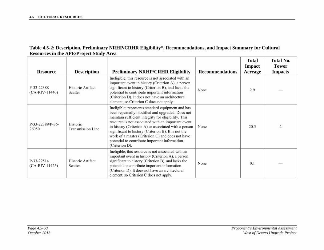
4.5 CULTURAL RESOURCES
Page 4.5-60 Proponent’s Environmental AssessmentOctober 2013 West of Devers Upgrade Project
Table 4.5-2: Description, Preliminary NRHP/CRHR Eligibility*, Recommendations, and Impact Summary for Cultural Resources in the APE/Project Study Area
Resource Description Preliminary NRHP/CRHR Eligibility Recommendations
Total Impact Acreage
Total No. Tower
Impacts
P-33-22388 (CA-RIV-11440)
Historic Artifact Scatter
Ineligible; this resource is not associated with an important event in history (Criterion A), a person significant to history (Criterion B), and lacks the potential to contribute important information (Criterion D). It does not have an architectural element, so Criterion C does not apply.
None 2.9 —
P-33-22389/P-36-26050
Historic Transmission Line
Ineligible; represents standard equipment and has been repeatedly modified and upgraded. Does not maintain sufficient integrity for eligibility. This resource is not associated with an important event in history (Criterion A) or associated with a person significant to history (Criterion B). It is not the work of a master (Criterion C) and does not have potential to contribute important information (Criterion D).
None 20.5 2
P-33-22514 (CA-RIV-11425)
Historic Artifact Scatter
Ineligible; this resource is not associated with an important event in history (Criterion A), a person significant to history (Criterion B), and lacks the potential to contribute important information (Criterion D). It does not have an architectural element, so Criterion C does not apply.
None 0.1 —
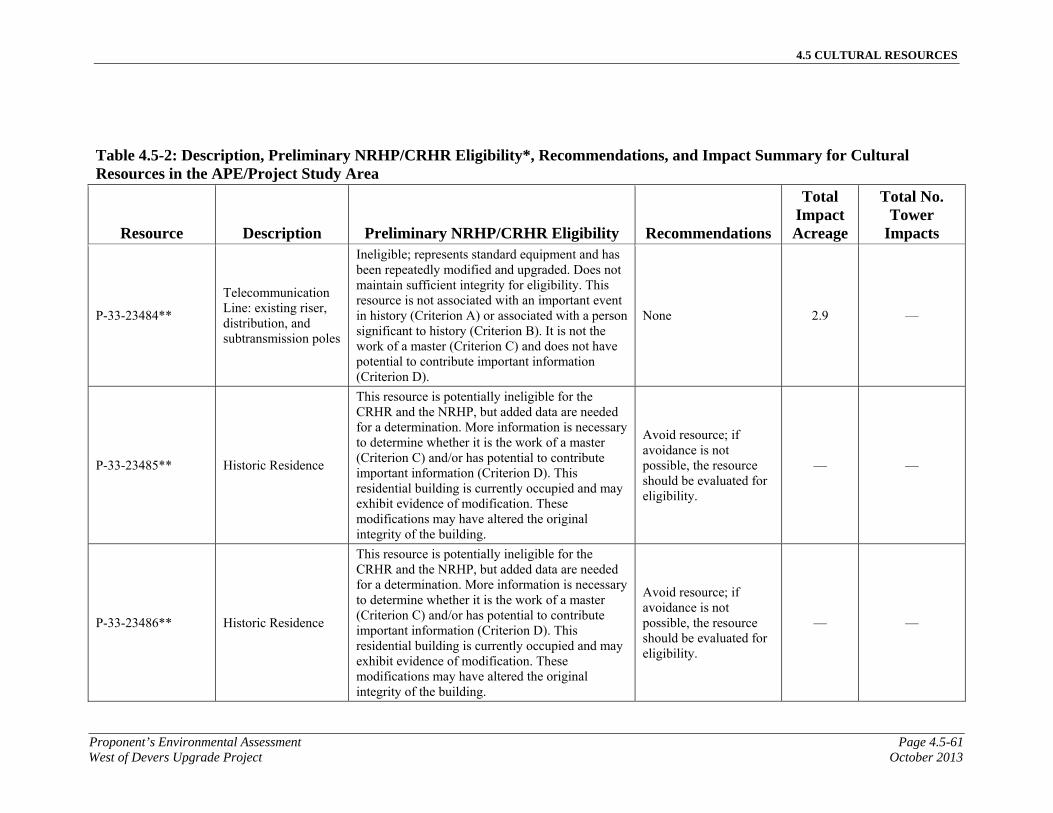
4.5 CULTURAL RESOURCES
Proponent’s Environmental Assessment Page 4.5-61West of Devers Upgrade Project October 2013
Table 4.5-2: Description, Preliminary NRHP/CRHR Eligibility*, Recommendations, and Impact Summary for Cultural Resources in the APE/Project Study Area
Resource Description Preliminary NRHP/CRHR Eligibility Recommendations
Total Impact Acreage
Total No. Tower
Impacts
P-33-23484**
Telecommunication Line: existing riser, distribution, and subtransmission poles
Ineligible; represents standard equipment and has been repeatedly modified and upgraded. Does not maintain sufficient integrity for eligibility. This resource is not associated with an important event in history (Criterion A) or associated with a person significant to history (Criterion B). It is not the work of a master (Criterion C) and does not have potential to contribute important information (Criterion D).
None 2.9 —
P-33-23485** Historic Residence
This resource is potentially ineligible for the CRHR and the NRHP, but added data are needed for a determination. More information is necessary to determine whether it is the work of a master (Criterion C) and/or has potential to contribute important information (Criterion D). This residential building is currently occupied and may exhibit evidence of modification. These modifications may have altered the original integrity of the building.
Avoid resource; if avoidance is not possible, the resource should be evaluated for eligibility.
— —
P-33-23486** Historic Residence
This resource is potentially ineligible for the CRHR and the NRHP, but added data are needed for a determination. More information is necessary to determine whether it is the work of a master (Criterion C) and/or has potential to contribute important information (Criterion D). This residential building is currently occupied and may exhibit evidence of modification. These modifications may have altered the original integrity of the building.
Avoid resource; if avoidance is not possible, the resource should be evaluated for eligibility.
— —

4.5 CULTURAL RESOURCES
Page 4.5-62 Proponent’s Environmental AssessmentOctober 2013 West of Devers Upgrade Project
Table 4.5-2: Description, Preliminary NRHP/CRHR Eligibility*, Recommendations, and Impact Summary for Cultural Resources in the APE/Project Study Area
Resource Description Preliminary NRHP/CRHR Eligibility Recommendations
Total Impact Acreage
Total No. Tower
Impacts
P-33-23487** Historic Residence
This resource is potentially ineligible for the CRHR and the NRHP, but added data are needed for a determination. More information is necessary to determine whether it is the work of a master (Criterion C) and/or has potential to contribute important information (Criterion D). This residential building is currently occupied and may exhibit evidence of modification. These modifications may have altered the original integrity of the building.
Avoid resource; if avoidance is not possible, the resource should be evaluated for eligibility.
— —
P-33-23488** Historic Residence
This resource is potentially ineligible for the CRHR and the NRHP, but added data are needed for a determination. More information is necessary to determine whether it is the work of a master (Criterion C) and/or has potential to contribute important information (Criterion D). This residential building is currently occupied and may exhibit evidence of modification. These modifications may have altered the original integrity of the building.
Avoid resource; if avoidance is not possible, the resource should be evaluated for eligibility.
— —
P-33-23489** Historic Residence
This resource is potentially ineligible for the CRHR and the NRHP, but added data are needed for a determination. More information is necessary to determine whether it is the work of a master (Criterion C) and/or has potential to contribute important information (Criterion D). This residential building is currently occupied and may exhibit evidence of modification. These modifications may have altered the original integrity of the building.
Avoid resource; if avoidance is not possible, the resource should be evaluated for eligibility.
— —

4.5 CULTURAL RESOURCES
Proponent’s Environmental Assessment Page 4.5-63West of Devers Upgrade Project October 2013
Table 4.5-2: Description, Preliminary NRHP/CRHR Eligibility*, Recommendations, and Impact Summary for Cultural Resources in the APE/Project Study Area
Resource Description Preliminary NRHP/CRHR Eligibility Recommendations
Total Impact Acreage
Total No. Tower
Impacts
P-33-23490** Historic Residence
This resource is potentially ineligible for the CRHR and the NRHP, but added data are needed for a determination. More information is necessary to determine whether it is the work of a master (Criterion C) and/or has potential to contribute important information (Criterion D). This residential building is currently occupied and may exhibit evidence of modification. These modifications may have altered the original integrity of the building.
Avoid resource; if avoidance is not possible, the resource should be evaluated for eligibility.
— —
P-3-23491** Historic Residence
This resource is potentially ineligible for the CRHR and the NRHP, but added data are needed for a determination. More information is necessary to determine whether it is the work of a master (Criterion C) and/or has potential to contribute important information (Criterion D). This residential building is currently occupied and may exhibit evidence of modification. These modifications may have altered the original integrity of the building.
Avoid resource; if avoidance is not possible, the resource should be evaluated for eligibility.
— —
P-33-23492** Historic Residence
This resource is potentially ineligible for the CRHR and the NRHP, but added data are needed for a determination. More information is necessary to determine whether it is the work of a master (Criterion C) and/or has potential to contribute important information (Criterion D). This residential building is currently occupied and may exhibit evidence of modification. These modifications may have altered the original integrity of the building.
Avoid resource; if avoidance is not possible, the resource should be evaluated for eligibility.
— —

4.5 CULTURAL RESOURCES
Page 4.5-64 Proponent’s Environmental AssessmentOctober 2013 West of Devers Upgrade Project
Table 4.5-2: Description, Preliminary NRHP/CRHR Eligibility*, Recommendations, and Impact Summary for Cultural Resources in the APE/Project Study Area
Resource Description Preliminary NRHP/CRHR Eligibility Recommendations
Total Impact Acreage
Total No. Tower
Impacts
P-33-23493** Historic Residence
This resource is potentially ineligible for the CRHR and the NRHP, but added data are needed for a determination. More information is necessary to determine whether it is the work of a master (Criterion C) and/or has potential to contribute important information (Criterion D). This residential building is currently occupied and may exhibit evidence of modification. These modifications may have altered the original integrity of the building.
Avoid resource; if avoidance is not possible, the resource should be evaluated for eligibility.
— —
P-33-23494** Historic Residence
This resource is potentially ineligible for the CRHR and the NRHP, but added data are needed for a determination. More information is necessary to determine whether it is the work of a master (Criterion C) and/or has potential to contribute important information (Criterion D). This residential building is currently occupied and may exhibit evidence of modification. These modifications may have altered the original integrity of the building.
Avoid resource; if avoidance is not possible, the resource should be evaluated for eligibility.
— —
P-33-23495** Historic Residence
This resource is potentially ineligible for the CRHR and the NRHP, but added data are needed for a determination. More information is necessary to determine whether it is the work of a master (Criterion C) and/or has potential to contribute important information (Criterion D). This residential building is currently occupied and may exhibit evidence of modification. These modifications may have altered the original integrity of the building.
Avoid resource; if avoidance is not possible, the resource should be evaluated for eligibility.
— —
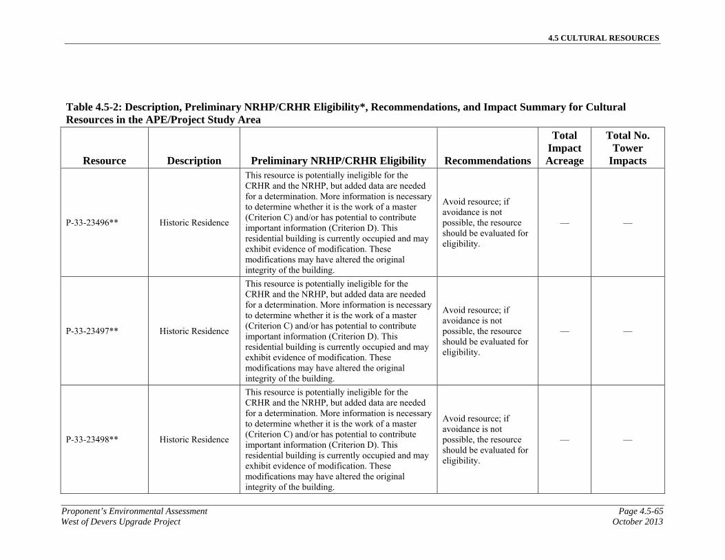
4.5 CULTURAL RESOURCES
Proponent’s Environmental Assessment Page 4.5-65West of Devers Upgrade Project October 2013
Table 4.5-2: Description, Preliminary NRHP/CRHR Eligibility*, Recommendations, and Impact Summary for Cultural Resources in the APE/Project Study Area
Resource Description Preliminary NRHP/CRHR Eligibility Recommendations
Total Impact Acreage
Total No. Tower
Impacts
P-33-23496** Historic Residence
This resource is potentially ineligible for the CRHR and the NRHP, but added data are needed for a determination. More information is necessary to determine whether it is the work of a master (Criterion C) and/or has potential to contribute important information (Criterion D). This residential building is currently occupied and may exhibit evidence of modification. These modifications may have altered the original integrity of the building.
Avoid resource; if avoidance is not possible, the resource should be evaluated for eligibility.
— —
P-33-23497** Historic Residence
This resource is potentially ineligible for the CRHR and the NRHP, but added data are needed for a determination. More information is necessary to determine whether it is the work of a master (Criterion C) and/or has potential to contribute important information (Criterion D). This residential building is currently occupied and may exhibit evidence of modification. These modifications may have altered the original integrity of the building.
Avoid resource; if avoidance is not possible, the resource should be evaluated for eligibility.
— —
P-33-23498** Historic Residence
This resource is potentially ineligible for the CRHR and the NRHP, but added data are needed for a determination. More information is necessary to determine whether it is the work of a master (Criterion C) and/or has potential to contribute important information (Criterion D). This residential building is currently occupied and may exhibit evidence of modification. These modifications may have altered the original integrity of the building.
Avoid resource; if avoidance is not possible, the resource should be evaluated for eligibility.
— —

4.5 CULTURAL RESOURCES
Page 4.5-66 Proponent’s Environmental AssessmentOctober 2013 West of Devers Upgrade Project
Table 4.5-2: Description, Preliminary NRHP/CRHR Eligibility*, Recommendations, and Impact Summary for Cultural Resources in the APE/Project Study Area
Resource Description Preliminary NRHP/CRHR Eligibility Recommendations
Total Impact Acreage
Total No. Tower
Impacts
P-33-23499** Historic Residence
This resource is potentially ineligible for the CRHR and the NRHP, but added data are needed for a determination. More information is necessary to determine whether it is the work of a master (Criterion C) and/or has potential to contribute important information (Criterion D). This residential building is currently occupied and may exhibit evidence of modification. These modifications may have altered the original integrity of the building.
Avoid resource; if avoidance is not possible, the resource should be evaluated for eligibility.
— —
P-33-23500** Historic Residence
This resource is potentially ineligible for the CRHR and the NRHP, but added data are needed for a determination. More information is necessary to determine whether it is the work of a master (Criterion C) and/or has potential to contribute important information (Criterion D). This residential building is currently occupied and may exhibit evidence of modification. These modifications may have altered the original integrity of the building.
Avoid resource; if avoidance is not possible, the resource should be evaluated for eligibility.
— —
P-33-23501** Historic Residence
This resource is potentially ineligible for the CRHR and the NRHP, but added data are needed for a determination. More information is necessary to determine whether it is the work of a master (Criterion C) and/or has potential to contribute important information (Criterion D). This residential building is currently occupied and may exhibit evidence of modification. These modifications may have altered the original integrity of the building.
Avoid resource; if avoidance is not possible, the resource should be evaluated for eligibility.
— —

4.5 CULTURAL RESOURCES
Proponent’s Environmental Assessment Page 4.5-67West of Devers Upgrade Project October 2013
Table 4.5-2: Description, Preliminary NRHP/CRHR Eligibility*, Recommendations, and Impact Summary for Cultural Resources in the APE/Project Study Area
Resource Description Preliminary NRHP/CRHR Eligibility Recommendations
Total Impact Acreage
Total No. Tower
Impacts
P-33-23502** Historic Residence
This resource is potentially ineligible for the CRHR and the NRHP, but added data are needed for a determination. More information is necessary to determine whether it is the work of a master (Criterion C) and/or has potential to contribute important information (Criterion D). This residential building is currently occupied and may exhibit evidence of modification. These modifications may have altered the original integrity of the building.
Avoid resource; if avoidance is not possible, the resource should be evaluated for eligibility.
— —
P-33-23503** Historic Residence
This resource is potentially ineligible for the CRHR and the NRHP, but added data are needed for a determination. More information is necessary to determine whether it is the work of a master (Criterion C) and/or has potential to contribute important information (Criterion D). This residential building is currently occupied and may exhibit evidence of modification. These modifications may have altered the original integrity of the building.
Avoid resource; if avoidance is not possible, the resource should be evaluated for eligibility.
— —
P-33-23504** Historic Residence
This resource is potentially ineligible for the CRHR and the NRHP, but added data are needed for a determination. More information is necessary to determine whether it is the work of a master (Criterion C) and/or has potential to contribute important information (Criterion D). This residential building is currently occupied and may exhibit evidence of modification. These modifications may have altered the original integrity of the building.
Avoid resource; if avoidance is not possible, the resource should be evaluated for eligibility.
— —

4.5 CULTURAL RESOURCES
Page 4.5-68 Proponent’s Environmental AssessmentOctober 2013 West of Devers Upgrade Project
Table 4.5-2: Description, Preliminary NRHP/CRHR Eligibility*, Recommendations, and Impact Summary for Cultural Resources in the APE/Project Study Area
Resource Description Preliminary NRHP/CRHR Eligibility Recommendations
Total Impact Acreage
Total No. Tower
Impacts
P-33-23505** Historic Residence
This resource is potentially ineligible for the CRHR and the NRHP, but added data are needed for a determination. More information is necessary to determine whether it is the work of a master (Criterion C) and/or has potential to contribute important information (Criterion D). This residential building is currently occupied and may exhibit evidence of modification. These modifications may have altered the original integrity of the building.
Avoid resource; if avoidance is not possible, the resource should be evaluated for eligibility.
— —
P-33-23506** Historic Residence
This resource is potentially ineligible for the CRHR and the NRHP, but added data are needed for a determination. More information is necessary to determine whether it is the work of a master (Criterion C) and/or has potential to contribute important information (Criterion D). This residential building is currently occupied and may exhibit evidence of modification. These modifications may have altered the original integrity of the building.
Avoid resource; if avoidance is not possible, the resource should be evaluated for eligibility.
— —
P-33-23507** Historic Residence
This resource is potentially ineligible for the CRHR and the NRHP, but added data are needed for a determination. More information is necessary to determine whether it is the work of a master (Criterion C) and/or has potential to contribute important information (Criterion D). This residential building is currently occupied and may exhibit evidence of modification. These modifications may have altered the original integrity of the building.
Avoid resource; if avoidance is not possible, the resource should be evaluated for eligibility.
— —

4.5 CULTURAL RESOURCES
Proponent’s Environmental Assessment Page 4.5-69West of Devers Upgrade Project October 2013
Table 4.5-2: Description, Preliminary NRHP/CRHR Eligibility*, Recommendations, and Impact Summary for Cultural Resources in the APE/Project Study Area
Resource Description Preliminary NRHP/CRHR Eligibility Recommendations
Total Impact Acreage
Total No. Tower
Impacts
P-33-23508** Historic Residence
This resource is potentially ineligible for the CRHR and the NRHP, but added data are needed for a determination. More information is necessary to determine whether it is the work of a master (Criterion C) and/or has potential to contribute important information (Criterion D). This residential building is currently occupied and may exhibit evidence of modification. These modifications may have altered the original integrity of the building.
Avoid resource; if avoidance is not possible, the resource should be evaluated for eligibility.
— —
P-33-23509** Historic Residence
This resource is potentially ineligible for the CRHR and the NRHP, but added data are needed for a determination. More information is necessary to determine whether it is the work of a master (Criterion C) and/or has potential to contribute important information (Criterion D). This residential building is currently occupied and may exhibit evidence of modification. These modifications may have altered the original integrity of the building.
Avoid resource; if avoidance is not possible, the resource should be evaluated for eligibility.
— —
P-33-23510** Historic Residence
This resource is potentially ineligible for the CRHR and the NRHP, but added data are needed for a determination. More information is necessary to determine whether it is the work of a master (Criterion C) and/or has potential to contribute important information (Criterion D). This residential building is currently occupied and may exhibit evidence of modification. These modifications may have altered the original integrity of the building.
Avoid resource; if avoidance is not possible, the resource should be evaluated for eligibility.
— —

4.5 CULTURAL RESOURCES
Page 4.5-70 Proponent’s Environmental AssessmentOctober 2013 West of Devers Upgrade Project
Table 4.5-2: Description, Preliminary NRHP/CRHR Eligibility*, Recommendations, and Impact Summary for Cultural Resources in the APE/Project Study Area
Resource Description Preliminary NRHP/CRHR Eligibility Recommendations
Total Impact Acreage
Total No. Tower
Impacts
P-33-23511** Historic Residence
This resource is potentially ineligible for the CRHR and the NRHP, but added data are needed for a determination. More information is necessary to determine whether it is the work of a master (Criterion C) and/or has potential to contribute important information (Criterion D). This residential building is currently occupied and may exhibit evidence of modification. These modifications may have altered the original integrity of the building.
Avoid resource; if avoidance is not possible, the resource should be evaluated for eligibility.
— —
P-33-23512** Historic Residence
This resource is potentially ineligible for the CRHR and the NRHP, but added data are needed for a determination. More information is necessary to determine whether it is the work of a master (Criterion C) and/or has potential to contribute important information (Criterion D). This residential building is currently occupied and may exhibit evidence of modification. These modifications may have altered the original integrity of the building.
Avoid resource; if avoidance is not possible, the resource should be evaluated for eligibility.
— —
P-33-23513** Historic Housing
Tract
This resource is potentially ineligible for the CRHR and the NRHP, but added data are needed for a determination. More information is necessary to determine whether it is the work of a master (Criterion C) and/or has potential to contribute important information (Criterion D). This residential building is currently occupied and may exhibit evidence of modification. These modifications may have altered the original integrity of the building.
Avoid resource; if avoidance is not possible, the resource should be evaluated for eligibility.
— —

4.5 CULTURAL RESOURCES
Proponent’s Environmental Assessment Page 4.5-71West of Devers Upgrade Project October 2013
Table 4.5-2: Description, Preliminary NRHP/CRHR Eligibility*, Recommendations, and Impact Summary for Cultural Resources in the APE/Project Study Area
Resource Description Preliminary NRHP/CRHR Eligibility Recommendations
Total Impact Acreage
Total No. Tower
Impacts
P-33-23514** Historic Residence
This resource is potentially ineligible for the CRHR and the NRHP, but added data are needed for a determination. More information is necessary to determine whether it is the work of a master (Criterion C) and/or has potential to contribute important information (Criterion D). This residential building is currently occupied and may exhibit evidence of modification. These modifications may have altered the original integrity of the building.
Avoid resource; if avoidance is not possible, the resource should be evaluated for eligibility.
— —
P-33-23515** Historic Residence
This resource is potentially ineligible for the CRHR and the NRHP, but added data are needed for a determination. More information is necessary to determine whether it is the work of a master (Criterion C) and/or has potential to contribute important information (Criterion D). This residential building is currently occupied and may exhibit evidence of modification. These modifications may have altered the original integrity of the building.
Avoid resource; if avoidance is not possible, the resource should be evaluated for eligibility.
— —
P-33-23516** Historic Residence
This resource is potentially ineligible for the CRHR and the NRHP, but added data are needed for a determination. More information is necessary to determine whether it is the work of a master (Criterion C) and/or has potential to contribute important information (Criterion D). This residential building is currently occupied and may exhibit evidence of modification. These modifications may have altered the original integrity of the building.
Avoid resource; if avoidance is not possible, the resource should be evaluated for eligibility.
— —

4.5 CULTURAL RESOURCES
Page 4.5-72 Proponent’s Environmental AssessmentOctober 2013 West of Devers Upgrade Project
Table 4.5-2: Description, Preliminary NRHP/CRHR Eligibility*, Recommendations, and Impact Summary for Cultural Resources in the APE/Project Study Area
Resource Description Preliminary NRHP/CRHR Eligibility Recommendations
Total Impact Acreage
Total No. Tower
Impacts
P-33-23517** Historic Residence
This resource is potentially ineligible for the CRHR and the NRHP, but added data are needed for a determination. More information is necessary to determine whether it is the work of a master (Criterion C) and/or has potential to contribute important information (Criterion D). This residential building is currently occupied and may exhibit evidence of modification. These modifications may have altered the original integrity of the building.
Avoid resource; if avoidance is not possible, the resource should be evaluated for eligibility.
— —
P-33-23518** Historic Residence
This resource is potentially ineligible for the CRHR and the NRHP, but added data are needed for a determination. More information is necessary to determine whether it is the work of a master (Criterion C) and/or has potential to contribute important information (Criterion D). This residential building is currently occupied and may exhibit evidence of modification. These modifications may have altered the original integrity of the building.
Avoid resource; if avoidance is not possible, the resource should be evaluated for eligibility.
— —
P-33-23519** Historic Residence
This resource is potentially ineligible for the CRHR and the NRHP, but added data are needed for a determination. More information is necessary to determine whether it is the work of a master (Criterion C) and/or has potential to contribute important information (Criterion D). This residential building is currently occupied and may exhibit evidence of modification. These modifications may have altered the original integrity of the building.
Avoid resource; if avoidance is not possible, the resource should be evaluated for eligibility.
— —

4.5 CULTURAL RESOURCES
Proponent’s Environmental Assessment Page 4.5-73West of Devers Upgrade Project October 2013
Table 4.5-2: Description, Preliminary NRHP/CRHR Eligibility*, Recommendations, and Impact Summary for Cultural Resources in the APE/Project Study Area
Resource Description Preliminary NRHP/CRHR Eligibility Recommendations
Total Impact Acreage
Total No. Tower
Impacts
P-33-23520** Historic Residence
This resource is potentially ineligible for the CRHR and the NRHP, but added data are needed for a determination. More information is necessary to determine whether it is the work of a master (Criterion C) and/or has potential to contribute important information (Criterion D). This residential building is currently occupied and may exhibit evidence of modification. These modifications may have altered the original integrity of the building.
Avoid resource; if avoidance is not possible, the resource should be evaluated for eligibility.
— —
P-33-23521** Historic Residence
This resource is potentially ineligible for the CRHR and the NRHP, but added data are needed for a determination. More information is necessary to determine whether it is the work of a master (Criterion C) and/or has potential to contribute important information (Criterion D). This residential building is currently occupied and may exhibit evidence of modification. These modifications may have altered the original integrity of the building.
Avoid resource; if avoidance is not possible, the resource should be evaluated for eligibility.
— —
P-33-23522** Historic Residence
This resource is potentially ineligible for the CRHR and the NRHP, but added data are needed for a determination. More information is necessary to determine whether it is the work of a master (Criterion C) and/or has potential to contribute important information (Criterion D). This residential building is currently occupied and may exhibit evidence of modification. These modifications may have altered the original integrity of the building.
Avoid resource; if avoidance is not possible, the resource should be evaluated for eligibility.
— —
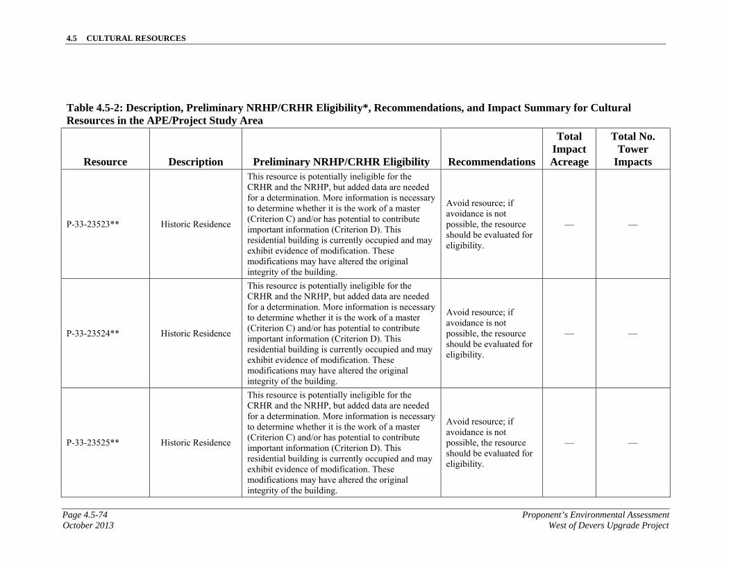
4.5 CULTURAL RESOURCES
Page 4.5-74 Proponent’s Environmental AssessmentOctober 2013 West of Devers Upgrade Project
Table 4.5-2: Description, Preliminary NRHP/CRHR Eligibility*, Recommendations, and Impact Summary for Cultural Resources in the APE/Project Study Area
Resource Description Preliminary NRHP/CRHR Eligibility Recommendations
Total Impact Acreage
Total No. Tower
Impacts
P-33-23523** Historic Residence
This resource is potentially ineligible for the CRHR and the NRHP, but added data are needed for a determination. More information is necessary to determine whether it is the work of a master (Criterion C) and/or has potential to contribute important information (Criterion D). This residential building is currently occupied and may exhibit evidence of modification. These modifications may have altered the original integrity of the building.
Avoid resource; if avoidance is not possible, the resource should be evaluated for eligibility.
— —
P-33-23524** Historic Residence
This resource is potentially ineligible for the CRHR and the NRHP, but added data are needed for a determination. More information is necessary to determine whether it is the work of a master (Criterion C) and/or has potential to contribute important information (Criterion D). This residential building is currently occupied and may exhibit evidence of modification. These modifications may have altered the original integrity of the building.
Avoid resource; if avoidance is not possible, the resource should be evaluated for eligibility.
— —
P-33-23525** Historic Residence
This resource is potentially ineligible for the CRHR and the NRHP, but added data are needed for a determination. More information is necessary to determine whether it is the work of a master (Criterion C) and/or has potential to contribute important information (Criterion D). This residential building is currently occupied and may exhibit evidence of modification. These modifications may have altered the original integrity of the building.
Avoid resource; if avoidance is not possible, the resource should be evaluated for eligibility.
— —

4.5 CULTURAL RESOURCES
Proponent’s Environmental Assessment Page 4.5-75West of Devers Upgrade Project October 2013
Table 4.5-2: Description, Preliminary NRHP/CRHR Eligibility*, Recommendations, and Impact Summary for Cultural Resources in the APE/Project Study Area
Resource Description Preliminary NRHP/CRHR Eligibility Recommendations
Total Impact Acreage
Total No. Tower
Impacts
P-33-23526** Historic Residence
This resource is potentially ineligible for the CRHR and the NRHP, but added data are needed for a determination. More information is necessary to determine whether it is the work of a master (Criterion C) and/or has potential to contribute important information (Criterion D). This residential building is currently occupied and may exhibit evidence of modification. These modifications may have altered the original integrity of the building.
Avoid resource; if avoidance is not possible, the resource should be evaluated for eligibility.
— —
P-33-23527** Historic Residence
This resource is potentially ineligible for the CRHR and the NRHP, but added data are needed for a determination. More information is necessary to determine whether it is the work of a master (Criterion C) and/or has potential to contribute important information (Criterion D). This residential building is currently occupied and may exhibit evidence of modification. These modifications may have altered the original integrity of the building.
Avoid resource; if avoidance is not possible, the resource should be evaluated for eligibility.
— —
P-33-23528** Historic Residence
This resource is potentially ineligible for the CRHR and the NRHP, but added data are needed for a determination. More information is necessary to determine whether it is the work of a master (Criterion C) and/or has potential to contribute important information (Criterion D). This residential building is currently occupied and may exhibit evidence of modification. These modifications may have altered the original integrity of the building.
Avoid resource; if avoidance is not possible, the resource should be evaluated for eligibility.
— —

4.5 CULTURAL RESOURCES
Page 4.5-76 Proponent’s Environmental AssessmentOctober 2013 West of Devers Upgrade Project
Table 4.5-2: Description, Preliminary NRHP/CRHR Eligibility*, Recommendations, and Impact Summary for Cultural Resources in the APE/Project Study Area
Resource Description Preliminary NRHP/CRHR Eligibility Recommendations
Total Impact Acreage
Total No. Tower
Impacts
P-33-23529** Historic Residence
This resource is potentially ineligible for the CRHR and the NRHP, but added data are needed for a determination. More information is necessary to determine whether it is the work of a master (Criterion C) and/or has potential to contribute important information (Criterion D). This residential building is currently occupied and may exhibit evidence of modification. These modifications may have altered the original integrity of the building.
Avoid resource; if avoidance is not possible, the resource should be evaluated for eligibility.
— —
P-33-23530** Historic Residence
This resource is potentially ineligible for the CRHR and the NRHP, but added data are needed for a determination. More information is necessary to determine whether it is the work of a master (Criterion C) and/or has potential to contribute important information (Criterion D). This residential building is currently occupied and may exhibit evidence of modification. These modifications may have altered the original integrity of the building.
Avoid resource; if avoidance is not possible, the resource should be evaluated for eligibility.
— —
P-33-23531** Historic Residence
This resource is potentially ineligible for the CRHR and the NRHP, but added data are needed for a determination. More information is necessary to determine whether it is the work of a master (Criterion C) and/or has potential to contribute important information (Criterion D). This residential building is currently occupied and may exhibit evidence of modification. These modifications may have altered the original integrity of the building.
Avoid resource; if avoidance is not possible, the resource should be evaluated for eligibility.
— —

4.5 CULTURAL RESOURCES
Proponent’s Environmental Assessment Page 4.5-77West of Devers Upgrade Project October 2013
Table 4.5-2: Description, Preliminary NRHP/CRHR Eligibility*, Recommendations, and Impact Summary for Cultural Resources in the APE/Project Study Area
Resource Description Preliminary NRHP/CRHR Eligibility Recommendations
Total Impact Acreage
Total No. Tower
Impacts
P-33-23532** Historic Residence
This resource is potentially ineligible for the CRHR and the NRHP, but added data are needed for a determination. More information is necessary to determine whether it is the work of a master (Criterion C) and/or has potential to contribute important information (Criterion D). This residential building is currently occupied and may exhibit evidence of modification. These modifications may have altered the original integrity of the building.
Avoid resource; if avoidance is not possible, the resource should be evaluated for eligibility.
— —
P-33-23533** Historic Residence
This resource is potentially ineligible for the CRHR and the NRHP, but added data are needed for a determination. More information is necessary to determine whether it is the work of a master (Criterion C) and/or has potential to contribute important information (Criterion D). This residential building is currently occupied and may exhibit evidence of modification. These modifications may have altered the original integrity of the building.
Avoid resource; if avoidance is not possible, the resource should be evaluated for eligibility.
— —
P-33-23534** Historic Residence
This resource is potentially ineligible for the CRHR and the NRHP, but added data are needed for a determination. More information is necessary to determine whether it is the work of a master (Criterion C) and/or has potential to contribute important information (Criterion D). This residential building is currently occupied and may exhibit evidence of modification. These modifications may have altered the original integrity of the building.
Avoid resource; if avoidance is not possible, the resource should be evaluated for eligibility.
— —

4.5 CULTURAL RESOURCES
Page 4.5-78 Proponent’s Environmental AssessmentOctober 2013 West of Devers Upgrade Project
Table 4.5-2: Description, Preliminary NRHP/CRHR Eligibility*, Recommendations, and Impact Summary for Cultural Resources in the APE/Project Study Area
Resource Description Preliminary NRHP/CRHR Eligibility Recommendations
Total Impact Acreage
Total No. Tower
Impacts
P-33-23535** Historic Residence
This resource is potentially ineligible for the CRHR and the NRHP, but added data are needed for a determination. More information is necessary to determine whether it is the work of a master (Criterion C) and/or has potential to contribute important information (Criterion D). This residential building is currently occupied and may exhibit evidence of modification. These modifications may have altered the original integrity of the building.
Avoid resource; if avoidance is not possible, the resource should be evaluated for eligibility.
— —
P-33-23536** Historic Residence
This resource is potentially ineligible for the CRHR and the NRHP, but added data are needed for a determination. More information is necessary to determine whether it is the work of a master (Criterion C) and/or has potential to contribute important information (Criterion D). This residential building is currently occupied and may exhibit evidence of modification. These modifications may have altered the original integrity of the building.
Avoid resource; if avoidance is not possible, the resource should be evaluated for eligibility.
— —
P-33-23537** Historic Residence
This resource is potentially ineligible for the CRHR and the NRHP, but added data are needed for a determination. More information is necessary to determine whether it is the work of a master (Criterion C) and/or has potential to contribute important information (Criterion D). This residential building is currently occupied and may exhibit evidence of modification. These modifications may have altered the original integrity of the building.
Avoid resource; if avoidance is not possible, the resource should be evaluated for eligibility.
— —

4.5 CULTURAL RESOURCES
Proponent’s Environmental Assessment Page 4.5-79West of Devers Upgrade Project October 2013
Table 4.5-2: Description, Preliminary NRHP/CRHR Eligibility*, Recommendations, and Impact Summary for Cultural Resources in the APE/Project Study Area
Resource Description Preliminary NRHP/CRHR Eligibility Recommendations
Total Impact Acreage
Total No. Tower
Impacts
P-33-23538** Historic Residence
This resource is potentially ineligible for the CRHR and the NRHP, but added data are needed for a determination. More information is necessary to determine whether it is the work of a master (Criterion C) and/or has potential to contribute important information (Criterion D). This residential building is currently occupied and may exhibit evidence of modification. These modifications may have altered the original integrity of the building.
Avoid resource; if avoidance is not possible, the resource should be evaluated for eligibility.
— —
P-33-23539** Historic Residence
This resource is potentially ineligible for the CRHR and the NRHP, but added data are needed for a determination. More information is necessary to determine whether it is the work of a master (Criterion C) and/or has potential to contribute important information (Criterion D). This residential building is currently occupied and may exhibit evidence of modification. These modifications may have altered the original integrity of the building.
Avoid resource; if avoidance is not possible, the resource should be evaluated for eligibility.
— —
P-33-23540** Historic Residence
This resource is potentially ineligible for the CRHR and the NRHP, but added data are needed for a determination. More information is necessary to determine whether it is the work of a master (Criterion C) and/or has potential to contribute important information (Criterion D). This residential building is currently occupied and may exhibit evidence of modification. These modifications may have altered the original integrity of the building.
Avoid resource; if avoidance is not possible, the resource should be evaluated for eligibility.
— —

4.5 CULTURAL RESOURCES
Page 4.5-80 Proponent’s Environmental AssessmentOctober 2013 West of Devers Upgrade Project
Table 4.5-2: Description, Preliminary NRHP/CRHR Eligibility*, Recommendations, and Impact Summary for Cultural Resources in the APE/Project Study Area
Resource Description Preliminary NRHP/CRHR Eligibility Recommendations
Total Impact Acreage
Total No. Tower
Impacts
P-33-23541** Historic Residence
This resource is potentially ineligible for the CRHR and the NRHP, but added data are needed for a determination. More information is necessary to determine whether it is the work of a master (Criterion C) and/or has potential to contribute important information (Criterion D). This residential building is currently occupied and may exhibit evidence of modification. These modifications may have altered the original integrity of the building.
Avoid resource; if avoidance is not possible, the resource should be evaluated for eligibility.
— —
P-33-23542** Historic Residence
This resource is potentially ineligible for the CRHR and the NRHP, but added data are needed for a determination. More information is necessary to determine whether it is the work of a master (Criterion C) and/or has potential to contribute important information (Criterion D). This residential building is currently occupied and may exhibit evidence of modification. These modifications may have altered the original integrity of the building.
Avoid resource; if avoidance is not possible, the resource should be evaluated for eligibility.
— —
P-33-23543** Historic Residence
This resource is potentially ineligible for the CRHR and the NRHP, but added data are needed for a determination. More information is necessary to determine whether it is the work of a master (Criterion C) and/or has potential to contribute important information (Criterion D). This residential building is currently occupied and may exhibit evidence of modification. These modifications may have altered the original integrity of the building.
Avoid resource; if avoidance is not possible, the resource should be evaluated for eligibility.
— —

4.5 CULTURAL RESOURCES
Proponent’s Environmental Assessment Page 4.5-81West of Devers Upgrade Project October 2013
Table 4.5-2: Description, Preliminary NRHP/CRHR Eligibility*, Recommendations, and Impact Summary for Cultural Resources in the APE/Project Study Area
Resource Description Preliminary NRHP/CRHR Eligibility Recommendations
Total Impact Acreage
Total No. Tower
Impacts
P-33-23544** Historic Residence
This resource is potentially ineligible for the CRHR and the NRHP, but added data are needed for a determination. More information is necessary to determine whether it is the work of a master (Criterion C) and/or has potential to contribute important information (Criterion D). This residential building is currently occupied and may exhibit evidence of modification. These modifications may have altered the original integrity of the building.
Avoid resource; if avoidance is not possible, the resource should be evaluated for eligibility.
— —
P-33-23545** Historic Residence
This resource is potentially ineligible for the CRHR and the NRHP, but added data are needed for a determination. More information is necessary to determine whether it is the work of a master (Criterion C) and/or has potential to contribute important information (Criterion D). This residential building is currently occupied and may exhibit evidence of modification. These modifications may have altered the original integrity of the building.
Avoid resource; if avoidance is not possible, the resource should be evaluated for eligibility.
— —
P-33-23546** Historic Residence
This resource is potentially ineligible for the CRHR and the NRHP, but added data are needed for a determination. More information is necessary to determine whether it is the work of a master (Criterion C) and/or has potential to contribute important information (Criterion D). This residential building is currently occupied and may exhibit evidence of modification. These modifications may have altered the original integrity of the building.
Avoid resource; if avoidance is not possible, the resource should be evaluated for eligibility.
— —

4.5 CULTURAL RESOURCES
Page 4.5-82 Proponent’s Environmental AssessmentOctober 2013 West of Devers Upgrade Project
Table 4.5-2: Description, Preliminary NRHP/CRHR Eligibility*, Recommendations, and Impact Summary for Cultural Resources in the APE/Project Study Area
Resource Description Preliminary NRHP/CRHR Eligibility Recommendations
Total Impact Acreage
Total No. Tower
Impacts
P-33-23547** Historic Residence
This resource is potentially ineligible for the CRHR and the NRHP, but added data are needed for a determination. More information is necessary to determine whether it is the work of a master (Criterion C) and/or has potential to contribute important information (Criterion D). This residential building is currently occupied and may exhibit evidence of modification. These modifications may have altered the original integrity of the building.
Avoid resource; if avoidance is not possible, the resource should be evaluated for eligibility.
— —
P-33-23548** Historic Residence
This resource is potentially ineligible for the CRHR and the NRHP, but added data are needed for a determination. More information is necessary to determine whether it is the work of a master (Criterion C) and/or has potential to contribute important information (Criterion D). This residential building is currently occupied and may exhibit evidence of modification. These modifications may have altered the original integrity of the building.
Avoid resource; if avoidance is not possible, the resource should be evaluated for eligibility.
— —
P-33-23549** Historic Housing
Tract
This resource is potentially ineligible for the CRHR and the NRHP, but added data are needed for a determination. More information is necessary to determine whether it is the work of a master (Criterion C) and/or has potential to contribute important information (Criterion D). This residential building is currently occupied and may exhibit evidence of modification. These modifications may have altered the original integrity of the building.
Avoid resource; if avoidance is not possible, the resource should be evaluated for eligibility.
— —

4.5 CULTURAL RESOURCES
Proponent’s Environmental Assessment Page 4.5-83West of Devers Upgrade Project October 2013
Table 4.5-2: Description, Preliminary NRHP/CRHR Eligibility*, Recommendations, and Impact Summary for Cultural Resources in the APE/Project Study Area
Resource Description Preliminary NRHP/CRHR Eligibility Recommendations
Total Impact Acreage
Total No. Tower
Impacts
P-33-23550** Historic Residence
This resource is potentially ineligible for the CRHR and the NRHP, but added data are needed for a determination. More information is necessary to determine whether it is the work of a master (Criterion C) and/or has potential to contribute important information (Criterion D). This residential building is currently occupied and may exhibit evidence of modification. These modifications may have altered the original integrity of the building.
Avoid resource; if avoidance is not possible, the resource should be evaluated for eligibility.
— —
P-33-23551** Historic Residence
This resource is potentially ineligible for the CRHR and the NRHP, but added data are needed for a determination. More information is necessary to determine whether it is the work of a master (Criterion C) and/or has potential to contribute important information (Criterion D). This residential building is currently occupied and may exhibit evidence of modification. These modifications may have altered the original integrity of the building.
Avoid resource; if avoidance is not possible, the resource should be evaluated for eligibility.
— —
P-33-23552** Historic Housing
Tract
This resource is potentially ineligible for the CRHR and the NRHP, but added data are needed for a determination. More information is necessary to determine whether it is the work of a master (Criterion C) and/or has potential to contribute important information (Criterion D). This residential building is currently occupied and may exhibit evidence of modification. These modifications may have altered the original integrity of the building.
Avoid resource; if avoidance is not possible, the resource should be evaluated for eligibility.
— —

4.5 CULTURAL RESOURCES
Page 4.5-84 Proponent’s Environmental AssessmentOctober 2013 West of Devers Upgrade Project
Table 4.5-2: Description, Preliminary NRHP/CRHR Eligibility*, Recommendations, and Impact Summary for Cultural Resources in the APE/Project Study Area
Resource Description Preliminary NRHP/CRHR Eligibility Recommendations
Total Impact Acreage
Total No. Tower
Impacts
P-33-23553** Historic Residence
This resource is potentially ineligible for the CRHR and the NRHP, but added data are needed for a determination. More information is necessary to determine whether it is the work of a master (Criterion C) and/or has potential to contribute important information (Criterion D). This residential building is currently occupied and may exhibit evidence of modification. These modifications may have altered the original integrity of the building.
Avoid resource; if avoidance is not possible, the resource should be evaluated for eligibility.
— —
P-33-23554** Historic Residence
This resource is potentially ineligible for the CRHR and the NRHP, but added data are needed for a determination. More information is necessary to determine whether it is the work of a master (Criterion C) and/or has potential to contribute important information (Criterion D). This residential building is currently occupied and may exhibit evidence of modification. These modifications may have altered the original integrity of the building.
Avoid resource; if avoidance is not possible, the resource should be evaluated for eligibility.
— —
P-33-23555** Historic Residence
This resource is potentially ineligible for the CRHR and the NRHP, but added data are needed for a determination. More information is necessary to determine whether it is the work of a master (Criterion C) and/or has potential to contribute important information (Criterion D). This residential building is currently occupied and may exhibit evidence of modification. These modifications may have altered the original integrity of the building.
Avoid resource; if avoidance is not possible, the resource should be evaluated for eligibility.
— —
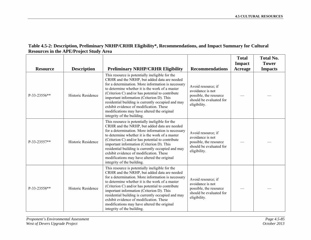
4.5 CULTURAL RESOURCES
Proponent’s Environmental Assessment Page 4.5-85West of Devers Upgrade Project October 2013
Table 4.5-2: Description, Preliminary NRHP/CRHR Eligibility*, Recommendations, and Impact Summary for Cultural Resources in the APE/Project Study Area
Resource Description Preliminary NRHP/CRHR Eligibility Recommendations
Total Impact Acreage
Total No. Tower
Impacts
P-33-23556** Historic Residence
This resource is potentially ineligible for the CRHR and the NRHP, but added data are needed for a determination. More information is necessary to determine whether it is the work of a master (Criterion C) and/or has potential to contribute important information (Criterion D). This residential building is currently occupied and may exhibit evidence of modification. These modifications may have altered the original integrity of the building.
Avoid resource; if avoidance is not possible, the resource should be evaluated for eligibility.
— —
P-33-23557** Historic Residence
This resource is potentially ineligible for the CRHR and the NRHP, but added data are needed for a determination. More information is necessary to determine whether it is the work of a master (Criterion C) and/or has potential to contribute important information (Criterion D). This residential building is currently occupied and may exhibit evidence of modification. These modifications may have altered the original integrity of the building.
Avoid resource; if avoidance is not possible, the resource should be evaluated for eligibility.
— —
P-33-23558** Historic Residence
This resource is potentially ineligible for the CRHR and the NRHP, but added data are needed for a determination. More information is necessary to determine whether it is the work of a master (Criterion C) and/or has potential to contribute important information (Criterion D). This residential building is currently occupied and may exhibit evidence of modification. These modifications may have altered the original integrity of the building.
Avoid resource; if avoidance is not possible, the resource should be evaluated for eligibility.
— —

4.5 CULTURAL RESOURCES
Page 4.5-86 Proponent’s Environmental AssessmentOctober 2013 West of Devers Upgrade Project
Table 4.5-2: Description, Preliminary NRHP/CRHR Eligibility*, Recommendations, and Impact Summary for Cultural Resources in the APE/Project Study Area
Resource Description Preliminary NRHP/CRHR Eligibility Recommendations
Total Impact Acreage
Total No. Tower
Impacts
P-33-23559** Historic Housing
Tract
This resource is potentially ineligible for the CRHR and the NRHP, but added data are needed for a determination. More information is necessary to determine whether it is the work of a master (Criterion C) and/or has potential to contribute important information (Criterion D). This residential building is currently occupied and may exhibit evidence of modification. These modifications may have altered the original integrity of the building.
Avoid resource; if avoidance is not possible, the resource should be evaluated for eligibility.
— —
P-33-23560** Historic Residence
This resource is potentially ineligible for the CRHR and the NRHP, but added data are needed for a determination. More information is necessary to determine whether it is the work of a master (Criterion C) and/or has potential to contribute important information (Criterion D). This residential building is currently occupied and may exhibit evidence of modification. These modifications may have altered the original integrity of the building.
Avoid resource; if avoidance is not possible, the resource should be evaluated for eligibility.
— —
P-33-23561** Historic Residence
This resource is potentially ineligible for the CRHR and the NRHP, but added data are needed for a determination. More information is necessary to determine whether it is the work of a master (Criterion C) and/or has potential to contribute important information (Criterion D). This residential building is currently occupied and may exhibit evidence of modification. These modifications may have altered the original integrity of the building.
Avoid resource; if avoidance is not possible, the resource should be evaluated for eligibility.
— —

4.5 CULTURAL RESOURCES
Proponent’s Environmental Assessment Page 4.5-87West of Devers Upgrade Project October 2013
Table 4.5-2: Description, Preliminary NRHP/CRHR Eligibility*, Recommendations, and Impact Summary for Cultural Resources in the APE/Project Study Area
Resource Description Preliminary NRHP/CRHR Eligibility Recommendations
Total Impact Acreage
Total No. Tower
Impacts
P-33-23562** Historic Residence
This resource is potentially ineligible for the CRHR and the NRHP, but added data are needed for a determination. More information is necessary to determine whether it is the work of a master (Criterion C) and/or has potential to contribute important information (Criterion D). This residential building is currently occupied and may exhibit evidence of modification. These modifications may have altered the original integrity of the building.
Avoid resource; if avoidance is not possible, the resource should be evaluated for eligibility.
— —
P-33-23563** Historic Residence
This resource is potentially ineligible for the CRHR and the NRHP, but added data are needed for a determination. More information is necessary to determine whether it is the work of a master (Criterion C) and/or has potential to contribute important information (Criterion D). This residential building is currently occupied and may exhibit evidence of modification. These modifications may have altered the original integrity of the building.
Avoid resource; if avoidance is not possible, the resource should be evaluated for eligibility.
— —
P-33-23564** Historic Residence
This resource is potentially ineligible for the CRHR and the NRHP, but added data are needed for a determination. More information is necessary to determine whether it is the work of a master (Criterion C) and/or has potential to contribute important information (Criterion D). This residential building is currently occupied and may exhibit evidence of modification. These modifications may have altered the original integrity of the building.
Avoid resource; if avoidance is not possible, the resource should be evaluated for eligibility.
— —

4.5 CULTURAL RESOURCES
Page 4.5-88 Proponent’s Environmental AssessmentOctober 2013 West of Devers Upgrade Project
Table 4.5-2: Description, Preliminary NRHP/CRHR Eligibility*, Recommendations, and Impact Summary for Cultural Resources in the APE/Project Study Area
Resource Description Preliminary NRHP/CRHR Eligibility Recommendations
Total Impact Acreage
Total No. Tower
Impacts
P-33-23565** Historic Residence
This resource is potentially ineligible for the CRHR and the NRHP, but added data are needed for a determination. More information is necessary to determine whether it is the work of a master (Criterion C) and/or has potential to contribute important information (Criterion D). This residential building is currently occupied and may exhibit evidence of modification. These modifications may have altered the original integrity of the building.
Avoid resource; if avoidance is not possible, the resource should be evaluated for eligibility.
— —
P-33-23566** Historic Residence
This resource is potentially ineligible for the CRHR and the NRHP, but added data are needed for a determination. More information is necessary to determine whether it is the work of a master (Criterion C) and/or has potential to contribute important information (Criterion D). This residential building is currently occupied and may exhibit evidence of modification. These modifications may have altered the original integrity of the building.
Avoid resource; if avoidance is not possible, the resource should be evaluated for eligibility.
— —
P-33-23567** Historic Residence
This resource is potentially ineligible for the CRHR and the NRHP, but added data are needed for a determination. More information is necessary to determine whether it is the work of a master (Criterion C) and/or has potential to contribute important information (Criterion D). This residential building is currently occupied and may exhibit evidence of modification. These modifications may have altered the original integrity of the building.
Avoid resource; if avoidance is not possible, the resource should be evaluated for eligibility.
— —

4.5 CULTURAL RESOURCES
Proponent’s Environmental Assessment Page 4.5-89West of Devers Upgrade Project October 2013
Table 4.5-2: Description, Preliminary NRHP/CRHR Eligibility*, Recommendations, and Impact Summary for Cultural Resources in the APE/Project Study Area
Resource Description Preliminary NRHP/CRHR Eligibility Recommendations
Total Impact Acreage
Total No. Tower
Impacts
P-33-23568** Historic Residence
This resource is potentially ineligible for the CRHR and the NRHP, but added data are needed for a determination. More information is necessary to determine whether it is the work of a master (Criterion C) and/or has potential to contribute important information (Criterion D). This residential building is currently occupied and may exhibit evidence of modification. These modifications may have altered the original integrity of the building.
Avoid resource; if avoidance is not possible, the resource should be evaluated for eligibility.
— —
P-33-23569** Historic Residence
This resource is potentially ineligible for the CRHR and the NRHP, but added data are needed for a determination. More information is necessary to determine whether it is the work of a master (Criterion C) and/or has potential to contribute important information (Criterion D). This residential building is currently occupied and may exhibit evidence of modification. These modifications may have altered the original integrity of the building.
Avoid resource; if avoidance is not possible, the resource should be evaluated for eligibility.
— —
P-33-23570** Historic Housing
Tract
This resource is potentially ineligible for the CRHR and the NRHP, but added data are needed for a determination. More information is necessary to determine whether it is the work of a master (Criterion C) and/or has potential to contribute important information (Criterion D). This residential building is currently occupied and may exhibit evidence of modification. These modifications may have altered the original integrity of the building.
Avoid resource; if avoidance is not possible, the resource should be evaluated for eligibility.
— —

4.5 CULTURAL RESOURCES
Page 4.5-90 Proponent’s Environmental AssessmentOctober 2013 West of Devers Upgrade Project
Table 4.5-2: Description, Preliminary NRHP/CRHR Eligibility*, Recommendations, and Impact Summary for Cultural Resources in the APE/Project Study Area
Resource Description Preliminary NRHP/CRHR Eligibility Recommendations
Total Impact Acreage
Total No. Tower
Impacts
P-33-23571** Historic Residence
This resource is potentially ineligible for the CRHR and the NRHP, but added data are needed for a determination. More information is necessary to determine whether it is the work of a master (Criterion C) and/or has potential to contribute important information (Criterion D). This residential building is currently occupied and may exhibit evidence of modification. These modifications may have altered the original integrity of the building.
Avoid resource; if avoidance is not possible, the resource should be evaluated for eligibility.
— —
P-33-23572** Historic Residence
This resource is potentially ineligible for the CRHR and the NRHP, but added data are needed for a determination. More information is necessary to determine whether it is the work of a master (Criterion C) and/or has potential to contribute important information (Criterion D). This residential building is currently occupied and may exhibit evidence of modification. These modifications may have altered the original integrity of the building.
Avoid resource; if avoidance is not possible, the resource should be evaluated for eligibility.
— —
P-33-23573** Historic Residence
This resource is potentially ineligible for the CRHR and the NRHP, but added data are needed for a determination. More information is necessary to determine whether it is the work of a master (Criterion C) and/or has potential to contribute important information (Criterion D). This residential building is currently occupied and may exhibit evidence of modification. These modifications may have altered the original integrity of the building.
Avoid resource; if avoidance is not possible, the resource should be evaluated for eligibility.
— —

4.5 CULTURAL RESOURCES
Proponent’s Environmental Assessment Page 4.5-91West of Devers Upgrade Project October 2013
Table 4.5-2: Description, Preliminary NRHP/CRHR Eligibility*, Recommendations, and Impact Summary for Cultural Resources in the APE/Project Study Area
Resource Description Preliminary NRHP/CRHR Eligibility Recommendations
Total Impact Acreage
Total No. Tower
Impacts
P-33-23574** Historic Residence
This resource is potentially ineligible for the CRHR and the NRHP, but added data are needed for a determination. More information is necessary to determine whether it is the work of a master (Criterion C) and/or has potential to contribute important information (Criterion D). This residential building is currently occupied and may exhibit evidence of modification. These modifications may have altered the original integrity of the building.
Avoid resource; if avoidance is not possible, the resource should be evaluated for eligibility.
— —
P-33-23575** Historic Residence
This resource is potentially ineligible for the CRHR and the NRHP, but added data are needed for a determination. More information is necessary to determine whether it is the work of a master (Criterion C) and/or has potential to contribute important information (Criterion D). This residential building is currently occupied and may exhibit evidence of modification. These modifications may have altered the original integrity of the building.
Avoid resource; if avoidance is not possible, the resource should be evaluated for eligibility.
— —
P-33-23576** Historic Residence
This resource is potentially ineligible for the CRHR and the NRHP, but added data are needed for a determination. More information is necessary to determine whether it is the work of a master (Criterion C) and/or has potential to contribute important information (Criterion D). This residential building is currently occupied and may exhibit evidence of modification. These modifications may have altered the original integrity of the building.
Avoid resource; if avoidance is not possible, the resource should be evaluated for eligibility.
— —

4.5 CULTURAL RESOURCES
Page 4.5-92 Proponent’s Environmental AssessmentOctober 2013 West of Devers Upgrade Project
Table 4.5-2: Description, Preliminary NRHP/CRHR Eligibility*, Recommendations, and Impact Summary for Cultural Resources in the APE/Project Study Area
Resource Description Preliminary NRHP/CRHR Eligibility Recommendations
Total Impact Acreage
Total No. Tower
Impacts
P-33-23577** Historic Residence
This resource is potentially ineligible for the CRHR and the NRHP, but added data are needed for a determination. More information is necessary to determine whether it is the work of a master (Criterion C) and/or has potential to contribute important information (Criterion D). This residential building is currently occupied and may exhibit evidence of modification. These modifications may have altered the original integrity of the building.
Avoid resource; if avoidance is not possible, the resource should be evaluated for eligibility.
— —
P-33-23578** Historic Residence
This resource is potentially ineligible for the CRHR and the NRHP, but added data are needed for a determination. More information is necessary to determine whether it is the work of a master (Criterion C) and/or has potential to contribute important information (Criterion D). This residential building is currently occupied and may exhibit evidence of modification. These modifications may have altered the original integrity of the building.
Avoid resource; if avoidance is not possible, the resource should be evaluated for eligibility.
— —
P-33-23579** Historic Residence
This resource is potentially ineligible for the CRHR and the NRHP, but added data are needed for a determination. More information is necessary to determine whether it is the work of a master (Criterion C) and/or has potential to contribute important information (Criterion D). This residential building is currently occupied and may exhibit evidence of modification. These modifications may have altered the original integrity of the building.
Avoid resource; if avoidance is not possible, the resource should be evaluated for eligibility.
— —

4.5 CULTURAL RESOURCES
Proponent’s Environmental Assessment Page 4.5-93West of Devers Upgrade Project October 2013
Table 4.5-2: Description, Preliminary NRHP/CRHR Eligibility*, Recommendations, and Impact Summary for Cultural Resources in the APE/Project Study Area
Resource Description Preliminary NRHP/CRHR Eligibility Recommendations
Total Impact Acreage
Total No. Tower
Impacts
P-33-23580** Historic Residence
This resource is potentially ineligible for the CRHR and the NRHP, but added data are needed for a determination. More information is necessary to determine whether it is the work of a master (Criterion C) and/or has potential to contribute important information (Criterion D). This residential building is currently occupied and may exhibit evidence of modification. These modifications may have altered the original integrity of the building.
Avoid resource; if avoidance is not possible, the resource should be evaluated for eligibility.
— —
P-33-23581** Historic Residence
This resource is potentially ineligible for the CRHR and the NRHP, but added data are needed for a determination. More information is necessary to determine whether it is the work of a master (Criterion C) and/or has potential to contribute important information (Criterion D). This residential building is currently occupied and may exhibit evidence of modification. These modifications may have altered the original integrity of the building.
Avoid resource; if avoidance is not possible, the resource should be evaluated for eligibility.
— —
P-33-23582** Historic Residence
This resource is potentially ineligible for the CRHR and the NRHP, but added data are needed for a determination. More information is necessary to determine whether it is the work of a master (Criterion C) and/or has potential to contribute important information (Criterion D). This residential building is currently occupied and may exhibit evidence of modification. These modifications may have altered the original integrity of the building.
Avoid resource; if avoidance is not possible, the resource should be evaluated for eligibility.
— —

4.5 CULTURAL RESOURCES
Page 4.5-94 Proponent’s Environmental AssessmentOctober 2013 West of Devers Upgrade Project
Table 4.5-2: Description, Preliminary NRHP/CRHR Eligibility*, Recommendations, and Impact Summary for Cultural Resources in the APE/Project Study Area
Resource Description Preliminary NRHP/CRHR Eligibility Recommendations
Total Impact Acreage
Total No. Tower
Impacts
P-33-23583** Historic Residence
This resource is potentially ineligible for the CRHR and the NRHP, but added data are needed for a determination. More information is necessary to determine whether it is the work of a master (Criterion C) and/or has potential to contribute important information (Criterion D). This residential building is currently occupied and may exhibit evidence of modification. These modifications may have altered the original integrity of the building.
Avoid resource; if avoidance is not possible, the resource should be evaluated for eligibility.
— —
P-33-23584** Historic Residence
This resource is potentially ineligible for the CRHR and the NRHP, but added data are needed for a determination. More information is necessary to determine whether it is the work of a master (Criterion C) and/or has potential to contribute important information (Criterion D). This residential building is currently occupied and may exhibit evidence of modification. These modifications may have altered the original integrity of the building.
Avoid resource; if avoidance is not possible, the resource should be evaluated for eligibility.
— —
P-33-23585** Historic Housing
Tract
This resource is potentially ineligible for the CRHR and the NRHP, but added data are needed for a determination. More information is necessary to determine whether it is the work of a master (Criterion C) and/or has potential to contribute important information (Criterion D). This residential building is currently occupied and may exhibit evidence of modification. These modifications may have altered the original integrity of the building.
Avoid resource; if avoidance is not possible, the resource should be evaluated for eligibility.
— —

4.5 CULTURAL RESOURCES
Proponent’s Environmental Assessment Page 4.5-95West of Devers Upgrade Project October 2013
Table 4.5-2: Description, Preliminary NRHP/CRHR Eligibility*, Recommendations, and Impact Summary for Cultural Resources in the APE/Project Study Area
Resource Description Preliminary NRHP/CRHR Eligibility Recommendations
Total Impact Acreage
Total No. Tower
Impacts
P-33-23586** Historic Residence
This resource is potentially ineligible for the CRHR and the NRHP, but added data are needed for a determination. More information is necessary to determine whether it is the work of a master (Criterion C) and/or has potential to contribute important information (Criterion D). This residential building is currently occupied and may exhibit evidence of modification. These modifications may have altered the original integrity of the building.
Avoid resource; if avoidance is not possible, the resource should be evaluated for eligibility.
— —
P-33-23587** Historic Residence
This resource is potentially ineligible for the CRHR and the NRHP, but added data are needed for a determination. More information is necessary to determine whether it is the work of a master (Criterion C) and/or has potential to contribute important information (Criterion D). This residential building is currently occupied and may exhibit evidence of modification. These modifications may have altered the original integrity of the building.
Avoid resource; if avoidance is not possible, the resource should be evaluated for eligibility.
— —
P-33-23588** Historic Residence
This resource is potentially ineligible for the CRHR and the NRHP, but added data are needed for a determination. More information is necessary to determine whether it is the work of a master (Criterion C) and/or has potential to contribute important information (Criterion D). This residential building is currently occupied and may exhibit evidence of modification. These modifications may have altered the original integrity of the building.
Avoid resource; if avoidance is not possible, the resource should be evaluated for eligibility.
— —

4.5 CULTURAL RESOURCES
Page 4.5-96 Proponent’s Environmental AssessmentOctober 2013 West of Devers Upgrade Project
Table 4.5-2: Description, Preliminary NRHP/CRHR Eligibility*, Recommendations, and Impact Summary for Cultural Resources in the APE/Project Study Area
Resource Description Preliminary NRHP/CRHR Eligibility Recommendations
Total Impact Acreage
Total No. Tower
Impacts
P-33-23589** Historic Residence
This resource is potentially ineligible for the CRHR and the NRHP, but added data are needed for a determination. More information is necessary to determine whether it is the work of a master (Criterion C) and/or has potential to contribute important information (Criterion D). This residential building is currently occupied and may exhibit evidence of modification. These modifications may have altered the original integrity of the building.
Avoid resource; if avoidance is not possible, the resource should be evaluated for eligibility.
— —
P-33-23590** Historic Residence
This resource is potentially ineligible for the CRHR and the NRHP, but added data are needed for a determination. More information is necessary to determine whether it is the work of a master (Criterion C) and/or has potential to contribute important information (Criterion D). This residential building is currently occupied and may exhibit evidence of modification. These modifications may have altered the original integrity of the building.
Avoid resource; if avoidance is not possible, the resource should be evaluated for eligibility.
— —
P-33-23591** Historic Residence
This resource is potentially ineligible for the CRHR and the NRHP, but added data are needed for a determination. More information is necessary to determine whether it is the work of a master (Criterion C) and/or has potential to contribute important information (Criterion D). This residential building is currently occupied and may exhibit evidence of modification. These modifications may have altered the original integrity of the building.
Avoid resource; if avoidance is not possible, the resource should be evaluated for eligibility.
— —

4.5 CULTURAL RESOURCES
Proponent’s Environmental Assessment Page 4.5-97West of Devers Upgrade Project October 2013
Table 4.5-2: Description, Preliminary NRHP/CRHR Eligibility*, Recommendations, and Impact Summary for Cultural Resources in the APE/Project Study Area
Resource Description Preliminary NRHP/CRHR Eligibility Recommendations
Total Impact Acreage
Total No. Tower
Impacts
P-33-23592** Historic Residence
This resource is potentially ineligible for the CRHR and the NRHP, but added data are needed for a determination. More information is necessary to determine whether it is the work of a master (Criterion C) and/or has potential to contribute important information (Criterion D). This residential building is currently occupied and may exhibit evidence of modification. These modifications may have altered the original integrity of the building.
Avoid resource; if avoidance is not possible, the resource should be evaluated for eligibility.
— —
P-33-23593** Historic Residence
This resource is potentially ineligible for the CRHR and the NRHP, but added data are needed for a determination. More information is necessary to determine whether it is the work of a master (Criterion C) and/or has potential to contribute important information (Criterion D). This residential building is currently occupied and may exhibit evidence of modification. These modifications may have altered the original integrity of the building.
Avoid resource; if avoidance is not possible, the resource should be evaluated for eligibility.
— —
P-33-23594** Historic Residence
This resource is potentially ineligible for the CRHR and the NRHP, but added data are needed for a determination. More information is necessary to determine whether it is the work of a master (Criterion C) and/or has potential to contribute important information (Criterion D). This residential building is currently occupied and may exhibit evidence of modification. These modifications may have altered the original integrity of the building.
Avoid resource; if avoidance is not possible, the resource should be evaluated for eligibility.
— —

4.5 CULTURAL RESOURCES
Page 4.5-98 Proponent’s Environmental AssessmentOctober 2013 West of Devers Upgrade Project
Table 4.5-2: Description, Preliminary NRHP/CRHR Eligibility*, Recommendations, and Impact Summary for Cultural Resources in the APE/Project Study Area
Resource Description Preliminary NRHP/CRHR Eligibility Recommendations
Total Impact Acreage
Total No. Tower
Impacts
P-33-23595** Historic Residence
This resource is potentially ineligible for the CRHR and the NRHP, but added data are needed for a determination. More information is necessary to determine whether it is the work of a master (Criterion C) and/or has potential to contribute important information (Criterion D). This residential building is currently occupied and may exhibit evidence of modification. These modifications may have altered the original integrity of the building.
Avoid resource; if avoidance is not possible, the resource should be evaluated for eligibility.
— —
P-33-23596** Historic Residence
This resource is potentially ineligible for the CRHR and the NRHP, but added data are needed for a determination. More information is necessary to determine whether it is the work of a master (Criterion C) and/or has potential to contribute important information (Criterion D). This residential building is currently occupied and may exhibit evidence of modification. These modifications may have altered the original integrity of the building.
Avoid resource; if avoidance is not possible, the resource should be evaluated for eligibility.
— —
P-33-23597** Historic Residence
This resource is potentially ineligible for the CRHR and the NRHP, but added data are needed for a determination. More information is necessary to determine whether it is the work of a master (Criterion C) and/or has potential to contribute important information (Criterion D). This residential building is currently occupied and may exhibit evidence of modification. These modifications may have altered the original integrity of the building.
Avoid resource; if avoidance is not possible, the resource should be evaluated for eligibility.
— —
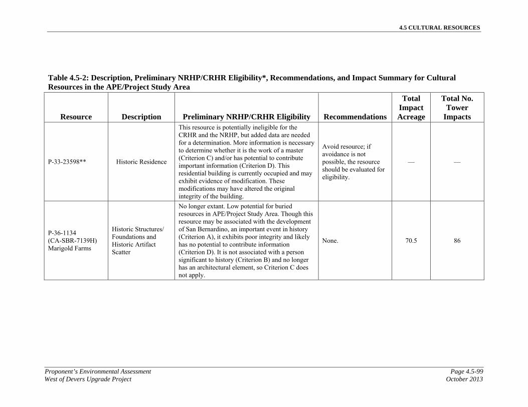
4.5 CULTURAL RESOURCES
Proponent’s Environmental Assessment Page 4.5-99West of Devers Upgrade Project October 2013
Table 4.5-2: Description, Preliminary NRHP/CRHR Eligibility*, Recommendations, and Impact Summary for Cultural Resources in the APE/Project Study Area
Resource Description Preliminary NRHP/CRHR Eligibility Recommendations
Total Impact Acreage
Total No. Tower
Impacts
P-33-23598** Historic Residence
This resource is potentially ineligible for the CRHR and the NRHP, but added data are needed for a determination. More information is necessary to determine whether it is the work of a master (Criterion C) and/or has potential to contribute important information (Criterion D). This residential building is currently occupied and may exhibit evidence of modification. These modifications may have altered the original integrity of the building.
Avoid resource; if avoidance is not possible, the resource should be evaluated for eligibility.
— —
P-36-1134 (CA-SBR-7139H) Marigold Farms
Historic Structures/Foundations and Historic Artifact Scatter
No longer extant. Low potential for buried resources in APE/Project Study Area. Though this resource may be associated with the development of San Bernardino, an important event in history (Criterion A), it exhibits poor integrity and likely has no potential to contribute information (Criterion D). It is not associated with a person significant to history (Criterion B) and no longer has an architectural element, so Criterion C does not apply.
None. 70.5 86
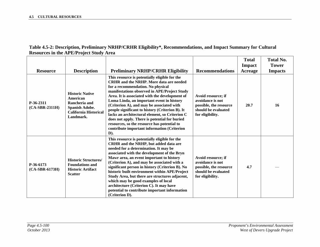
4.5 CULTURAL RESOURCES
Page 4.5-100 Proponent’s Environmental AssessmentOctober 2013 West of Devers Upgrade Project
Table 4.5-2: Description, Preliminary NRHP/CRHR Eligibility*, Recommendations, and Impact Summary for Cultural Resources in the APE/Project Study Area
Resource Description Preliminary NRHP/CRHR Eligibility Recommendations
Total Impact Acreage
Total No. Tower
Impacts
P-36-2311 (CA-SBR-2311H)
Historic Native American Rancheria and Spanish Adobe. California Historical Landmark.
This resource is potentially eligible for the CRHR and the NRHP. More data are needed for a recommendation. No physical manifestations observed in APE/Project Study Area. It is associated with the development of Loma Linda, an important event in history (Criterion A), and may be associated with people significant to history (Criterion B). It lacks an architectural element, so Criterion C does not apply. There is potential for buried resources, so the resource has potential to contribute important information (Criterion D).
Avoid resource; if avoidance is not possible, the resource should be evaluated for eligibility.
20.7 16
P-36-6173 (CA-SBR-6173H)
Historic Structures/Foundations and Historic Artifact Scatter
This resource is potentially eligible for the CRHR and the NRHP, but added data are needed for a determination. It may be associated with the development of the Bryn Mawr area, an event important to history (Criterion A), and may be associated with a significant person in history (Criterion B). No historic built environment within APE/Project Study Area, but there are structures adjacent, which may be good examples of local architecture (Criterion C). It may have potential to contribute important information (Criterion D).
Avoid resource; if avoidance is not possible, the resource should be evaluated for eligibility.
4.7 —
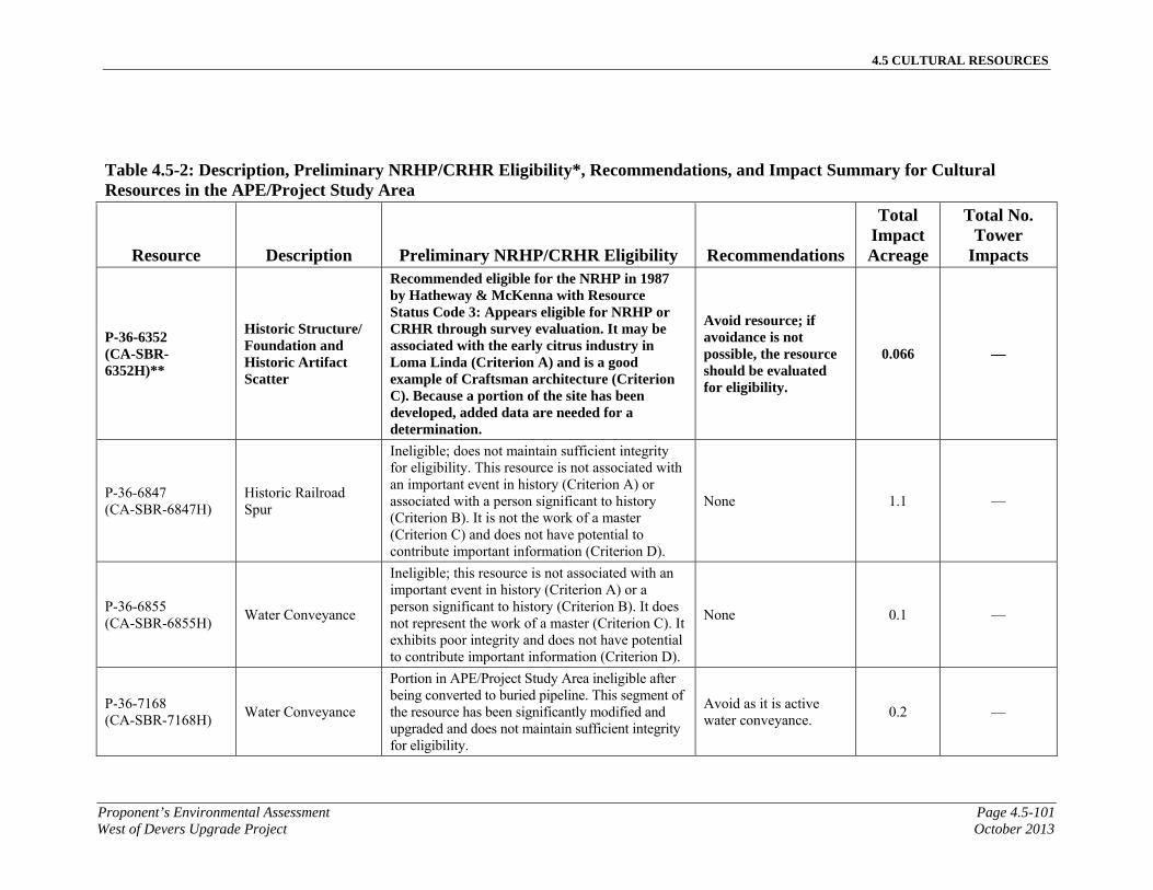
4.5 CULTURAL RESOURCES
Proponent’s Environmental Assessment Page 4.5-101West of Devers Upgrade Project October 2013
Table 4.5-2: Description, Preliminary NRHP/CRHR Eligibility*, Recommendations, and Impact Summary for Cultural Resources in the APE/Project Study Area
Resource Description Preliminary NRHP/CRHR Eligibility Recommendations
Total Impact Acreage
Total No. Tower
Impacts
P-36-6352 (CA-SBR-6352H)**
Historic Structure/Foundation and Historic Artifact Scatter
Recommended eligible for the NRHP in 1987 by Hatheway & McKenna with Resource Status Code 3: Appears eligible for NRHP or CRHR through survey evaluation. It may be associated with the early citrus industry in Loma Linda (Criterion A) and is a good example of Craftsman architecture (Criterion C). Because a portion of the site has been developed, added data are needed for a determination.
Avoid resource; if avoidance is not possible, the resource should be evaluated for eligibility.
0.066 —
P-36-6847 (CA-SBR-6847H)
Historic Railroad Spur
Ineligible; does not maintain sufficient integrity for eligibility. This resource is not associated with an important event in history (Criterion A) or associated with a person significant to history (Criterion B). It is not the work of a master (Criterion C) and does not have potential to contribute important information (Criterion D).
None 1.1 —
P-36-6855 (CA-SBR-6855H)
Water Conveyance
Ineligible; this resource is not associated with an important event in history (Criterion A) or a person significant to history (Criterion B). It does not represent the work of a master (Criterion C). It exhibits poor integrity and does not have potential to contribute important information (Criterion D).
None 0.1 —
P-36-7168 (CA-SBR-7168H)
Water Conveyance
Portion in APE/Project Study Area ineligible after being converted to buried pipeline. This segment of the resource has been significantly modified and upgraded and does not maintain sufficient integrity for eligibility.
Avoid as it is active water conveyance.
0.2 —
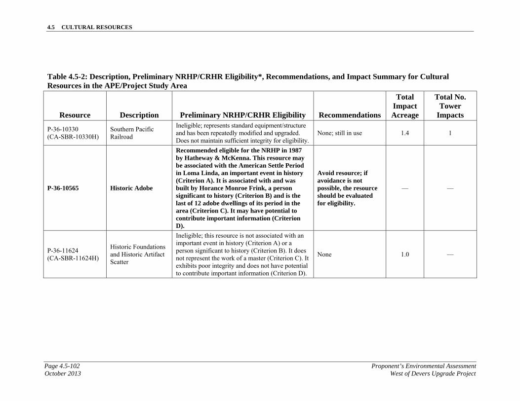
4.5 CULTURAL RESOURCES
Page 4.5-102 Proponent’s Environmental AssessmentOctober 2013 West of Devers Upgrade Project
Table 4.5-2: Description, Preliminary NRHP/CRHR Eligibility*, Recommendations, and Impact Summary for Cultural Resources in the APE/Project Study Area
Resource Description Preliminary NRHP/CRHR Eligibility Recommendations
Total Impact Acreage
Total No. Tower
Impacts
P-36-10330 (CA-SBR-10330H)
Southern Pacific Railroad
Ineligible; represents standard equipment/structure and has been repeatedly modified and upgraded. Does not maintain sufficient integrity for eligibility.
None; still in use 1.4 1
P-36-10565 Historic Adobe
Recommended eligible for the NRHP in 1987 by Hatheway & McKenna. This resource may be associated with the American Settle Period in Loma Linda, an important event in history (Criterion A). It is associated with and was built by Horance Monroe Frink, a person significant to history (Criterion B) and is the last of 12 adobe dwellings of its period in the area (Criterion C). It may have potential to contribute important information (Criterion D).
Avoid resource; if avoidance is not possible, the resource should be evaluated for eligibility.
— —
P-36-11624 (CA-SBR-11624H)
Historic Foundations and Historic Artifact Scatter
Ineligible; this resource is not associated with an important event in history (Criterion A) or a person significant to history (Criterion B). It does not represent the work of a master (Criterion C). It exhibits poor integrity and does not have potential to contribute important information (Criterion D).
None 1.0 —
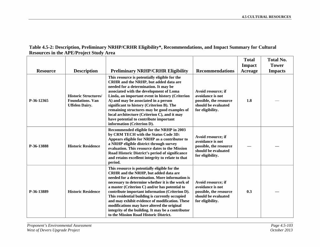
4.5 CULTURAL RESOURCES
Proponent’s Environmental Assessment Page 4.5-103West of Devers Upgrade Project October 2013
Table 4.5-2: Description, Preliminary NRHP/CRHR Eligibility*, Recommendations, and Impact Summary for Cultural Resources in the APE/Project Study Area
Resource Description Preliminary NRHP/CRHR Eligibility Recommendations
Total Impact Acreage
Total No. Tower
Impacts
P-36-12365 Historic Structures/ Foundations. Van Uffelen Dairy.
This resource is potentially eligible for the CRHR and the NRHP, but added data are needed for a determination. It may be associated with the development of Loma Linda, an important event in history (Criterion A) and may be associated in a person significant to history (Criterion B). The remaining structures may be good examples of local architecture (Criterion C), and it may have potential to contribute important information (Criterion D).
Avoid resource; if avoidance is not possible, the resource should be evaluated for eligibility.
1.8 —
P-36-13888 Historic Residence
Recommended eligible for the NRHP in 2003 by CRM TECH with the Status Code 3D: Appears eligible for NRHP as a contributor to a NRHP eligible district through survey evaluation. This resource dates to the Mission Road Historic District’s period of significance and retains excellent integrity to relate to that period.
Avoid resource; if avoidance is not possible, the resource should be evaluated for eligibility.
— —
P-36-13889 Historic Residence
This resource is potentially eligible for the CRHR and the NRHP, but added data are needed for a determination. More information is necessary to determine whether it is the work of a master (Criterion C) and/or has potential to contribute important information (Criterion D). This residential building is currently occupied and may exhibit evidence of modification. These modifications may have altered the original integrity of the building. It may be a contributor to the Mission Road Historic District.
Avoid resource; if avoidance is not possible, the resource should be evaluated for eligibility.
0.3 —

4.5 CULTURAL RESOURCES
Page 4.5-104 Proponent’s Environmental AssessmentOctober 2013 West of Devers Upgrade Project
Table 4.5-2: Description, Preliminary NRHP/CRHR Eligibility*, Recommendations, and Impact Summary for Cultural Resources in the APE/Project Study Area
Resource Description Preliminary NRHP/CRHR Eligibility Recommendations
Total Impact Acreage
Total No. Tower
Impacts
P-36-13891 Historic Residence
Recommended eligible for the NRHP in 2003 by CRM Tech with Resource Status Code 3D: Appears eligible for NRHP as a contributor to a NRHP-eligible district through survey evaluation because it contributes to the historic integrity of Mission Road Historic District.
Avoid resource; if avoidance is not possible, the resource should be evaluated for eligibility.
— —
P-36-19920 Historic Residence
Ineligible; evaluated in 2003 by CRM TECH with a Status Code 6Z: Found ineligible for NRHP, CRHR, or local designation through survey evaluation. This resource does not appear to meet any of the criteria for listing in the NRHP or CRHR and it does not contribute to the significance of the Mission Road Historic District.
None — —
P-36-19926 Historic Residence
Recommended eligible for the NRHP in 2003 by CRM Tech with Resource Status Code 3D: Appears eligible for NRHP as a contributor to a NRHP-eligible district through survey evaluation because it contributes to the historic integrity of Mission Road Historic District.
Avoid resource; if avoidance is not possible, the resource should be evaluated for eligibility.
— —
P-36-19927 Historic Residence
Recommended eligible for the NRHP in 2003 by CRM Tech with Resource Status Code 3D: Appears eligible for NRHP as a contributor to a NRHP-eligible district through survey evaluation because it contributes to the historic integrity of Mission Road Historic District.
Avoid resource; if avoidance is not possible, the resource should be evaluated for eligibility.
— —
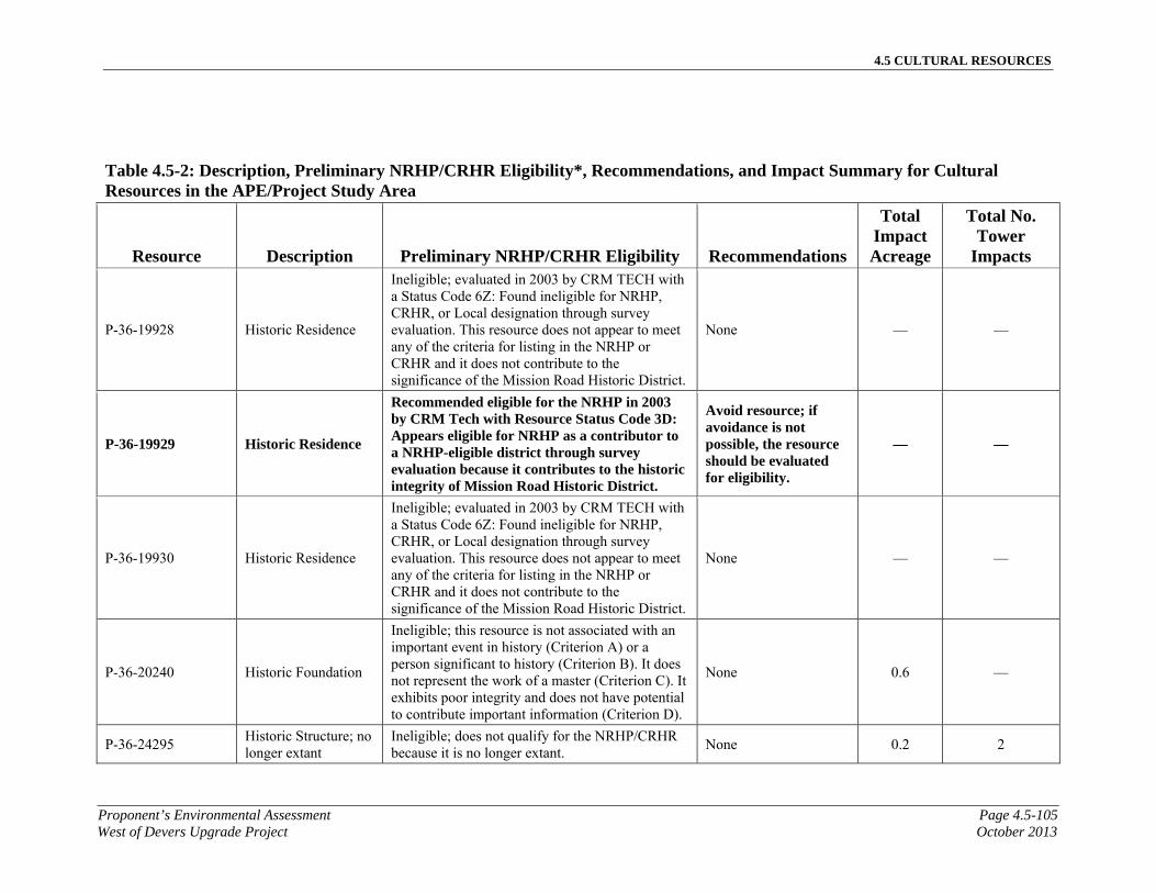
4.5 CULTURAL RESOURCES
Proponent’s Environmental Assessment Page 4.5-105West of Devers Upgrade Project October 2013
Table 4.5-2: Description, Preliminary NRHP/CRHR Eligibility*, Recommendations, and Impact Summary for Cultural Resources in the APE/Project Study Area
Resource Description Preliminary NRHP/CRHR Eligibility Recommendations
Total Impact Acreage
Total No. Tower
Impacts
P-36-19928 Historic Residence
Ineligible; evaluated in 2003 by CRM TECH with a Status Code 6Z: Found ineligible for NRHP, CRHR, or Local designation through survey evaluation. This resource does not appear to meet any of the criteria for listing in the NRHP or CRHR and it does not contribute to the significance of the Mission Road Historic District.
None — —
P-36-19929 Historic Residence
Recommended eligible for the NRHP in 2003 by CRM Tech with Resource Status Code 3D: Appears eligible for NRHP as a contributor to a NRHP-eligible district through survey evaluation because it contributes to the historic integrity of Mission Road Historic District.
Avoid resource; if avoidance is not possible, the resource should be evaluated for eligibility.
— —
P-36-19930 Historic Residence
Ineligible; evaluated in 2003 by CRM TECH with a Status Code 6Z: Found ineligible for NRHP, CRHR, or Local designation through survey evaluation. This resource does not appear to meet any of the criteria for listing in the NRHP or CRHR and it does not contribute to the significance of the Mission Road Historic District.
None — —
P-36-20240 Historic Foundation
Ineligible; this resource is not associated with an important event in history (Criterion A) or a person significant to history (Criterion B). It does not represent the work of a master (Criterion C). It exhibits poor integrity and does not have potential to contribute important information (Criterion D).
None 0.6 —
P-36-24295 Historic Structure; no longer extant
Ineligible; does not qualify for the NRHP/CRHR because it is no longer extant.
None 0.2 2
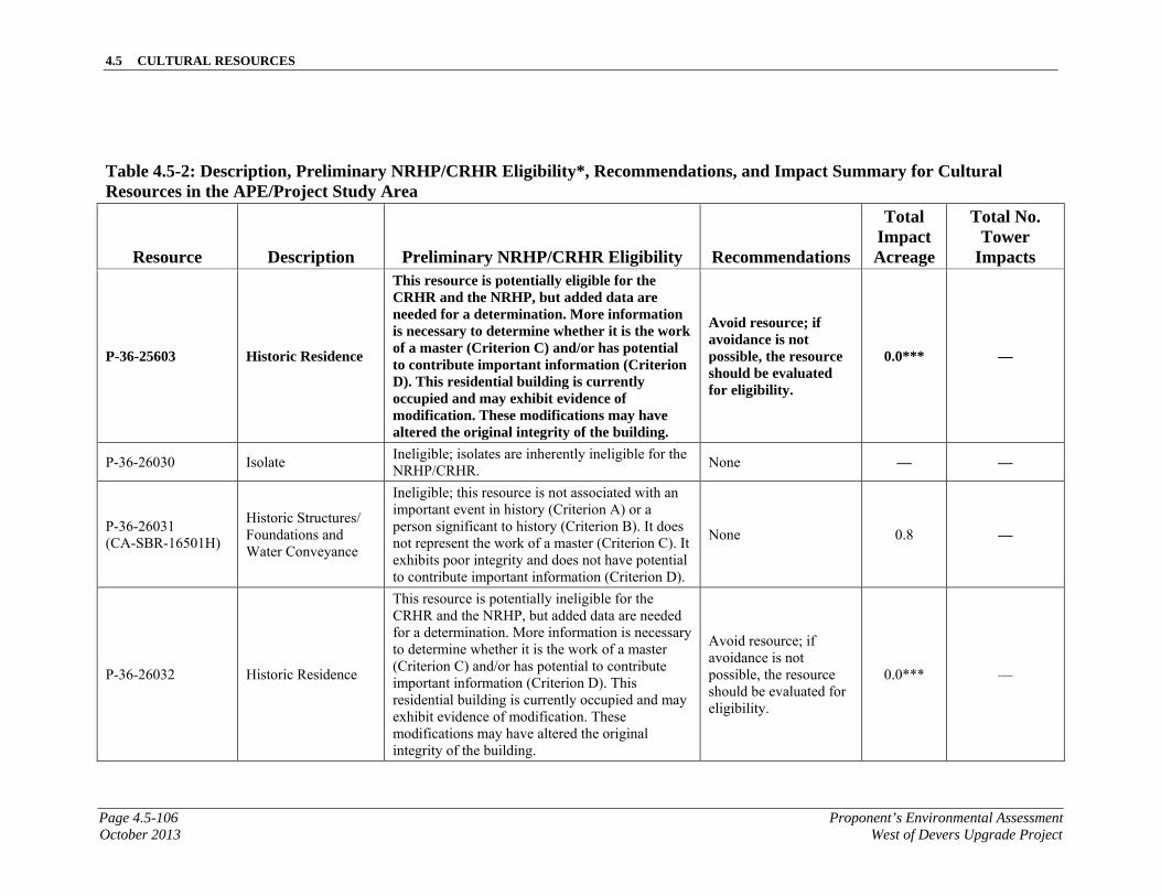
4.5 CULTURAL RESOURCES
Page 4.5-106 Proponent’s Environmental AssessmentOctober 2013 West of Devers Upgrade Project
Table 4.5-2: Description, Preliminary NRHP/CRHR Eligibility*, Recommendations, and Impact Summary for Cultural Resources in the APE/Project Study Area
Resource Description Preliminary NRHP/CRHR Eligibility Recommendations
Total Impact Acreage
Total No. Tower
Impacts
P-36-25603 Historic Residence
This resource is potentially eligible for the CRHR and the NRHP, but added data are needed for a determination. More information is necessary to determine whether it is the work of a master (Criterion C) and/or has potential to contribute important information (Criterion D). This residential building is currently occupied and may exhibit evidence of modification. These modifications may have altered the original integrity of the building.
Avoid resource; if avoidance is not possible, the resource should be evaluated for eligibility.
0.0*** —
P-36-26030 Isolate Ineligible; isolates are inherently ineligible for the NRHP/CRHR.
None — —
P-36-26031 (CA-SBR-16501H)
Historic Structures/Foundations and Water Conveyance
Ineligible; this resource is not associated with an important event in history (Criterion A) or a person significant to history (Criterion B). It does not represent the work of a master (Criterion C). It exhibits poor integrity and does not have potential to contribute important information (Criterion D).
None 0.8 —
P-36-26032 Historic Residence
This resource is potentially ineligible for the CRHR and the NRHP, but added data are needed for a determination. More information is necessary to determine whether it is the work of a master (Criterion C) and/or has potential to contribute important information (Criterion D). This residential building is currently occupied and may exhibit evidence of modification. These modifications may have altered the original integrity of the building.
Avoid resource; if avoidance is not possible, the resource should be evaluated for eligibility.
0.0*** —

4.5 CULTURAL RESOURCES
Proponent’s Environmental Assessment Page 4.5-107West of Devers Upgrade Project October 2013
Table 4.5-2: Description, Preliminary NRHP/CRHR Eligibility*, Recommendations, and Impact Summary for Cultural Resources in the APE/Project Study Area
Resource Description Preliminary NRHP/CRHR Eligibility Recommendations
Total Impact Acreage
Total No. Tower
Impacts
P-36-26033 Historic Residence
This resource is potentially ineligible for the CRHR and the NRHP, but added data are needed for a determination. More information is necessary to determine whether it is the work of a master (Criterion C) and/or has potential to contribute important information (Criterion D). This residential building is currently occupied and may exhibit evidence of modification. These modifications may have altered the original integrity of the building.
Avoid resource; if avoidance is not possible, the resource should be evaluated for eligibility.
0.0*** —
P-36-26034 Historic Residence
This resource is potentially ineligible for the CRHR and the NRHP, but added data are needed for a determination. More information is necessary to determine whether it is the work of a master (Criterion C) and/or has potential to contribute important information (Criterion D). This residential building is currently occupied and may exhibit evidence of modification. These modifications may have altered the original integrity of the building.
Avoid resource; if avoidance is not possible, the resource should be evaluated for eligibility.
0.1 —
P-36-26035 Historic Residence
This resource is potentially ineligible for the CRHR and the NRHP, but added data are needed for a determination. More information is necessary to determine whether it is the work of a master (Criterion C) and/or has potential to contribute important information (Criterion D). This residential building is currently occupied and may exhibit evidence of modification. These modifications may have altered the original integrity of the building.
Avoid resource; if avoidance is not possible, the resource should be evaluated for eligibility.
0.0*** —

4.5 CULTURAL RESOURCES
Page 4.5-108 Proponent’s Environmental AssessmentOctober 2013 West of Devers Upgrade Project
Table 4.5-2: Description, Preliminary NRHP/CRHR Eligibility*, Recommendations, and Impact Summary for Cultural Resources in the APE/Project Study Area
Resource Description Preliminary NRHP/CRHR Eligibility Recommendations
Total Impact Acreage
Total No. Tower
Impacts
P-36-26036 Historic Residence
This resource is potentially ineligible for the CRHR and the NRHP, but added data are needed for a determination. More information is necessary to determine whether it is the work of a master (Criterion C) and/or has potential to contribute important information (Criterion D). This residential building is currently occupied and may exhibit evidence of modification. These modifications may have altered the original integrity of the building.
Avoid resource; if avoidance is not possible, the resource should be evaluated for eligibility.
0.1 —
P-36-26037 Historic Residence
This resource is potentially ineligible for the CRHR and the NRHP, but added data are needed for a determination. More information is necessary to determine whether it is the work of a master (Criterion C) and/or has potential to contribute important information (Criterion D). This residential building is currently occupied and may exhibit evidence of modification. These modifications may have altered the original integrity of the building.
Avoid resource; if avoidance is not possible, the resource should be evaluated for eligibility.
0.1 —
P-36-26038 Historic Residence
This resource is potentially ineligible for the CRHR and the NRHP, but added data are needed for a determination. More information is necessary to determine whether it is the work of a master (Criterion C) and/or has potential to contribute important information (Criterion D). This residential building is currently occupied and may exhibit evidence of modification. These modifications may have altered the original integrity of the building.
Avoid resource; if avoidance is not possible, the resource should be evaluated for eligibility.
0.1 —

4.5 CULTURAL RESOURCES
Proponent’s Environmental Assessment Page 4.5-109West of Devers Upgrade Project October 2013
Table 4.5-2: Description, Preliminary NRHP/CRHR Eligibility*, Recommendations, and Impact Summary for Cultural Resources in the APE/Project Study Area
Resource Description Preliminary NRHP/CRHR Eligibility Recommendations
Total Impact Acreage
Total No. Tower
Impacts
P-36-26039 Historic Residence
This resource is potentially ineligible for the CRHR and the NRHP, but added data are needed for a determination. More information is necessary to determine whether it is the work of a master (Criterion C) and/or has potential to contribute important information (Criterion D). This residential building is currently occupied and may exhibit evidence of modification. These modifications may have altered the original integrity of the building.
Avoid resource; if avoidance is not possible, the resource should be evaluated for eligibility.
0.0*** —
P-36-26040 Historic Residence
This resource is potentially ineligible for the CRHR and the NRHP, but added data are needed for a determination. More information is necessary to determine whether it is the work of a master (Criterion C) and/or has potential to contribute important information (Criterion D). This residential building is currently occupied and may exhibit evidence of modification. These modifications may have altered the original integrity of the building.
Avoid resource; if avoidance is not possible, the resource should be evaluated for eligibility.
0.0*** —
P-36-26041 Historic Residence
This resource is potentially ineligible for the CRHR and the NRHP, but added data are needed for a determination. More information is necessary to determine whether it is the work of a master (Criterion C) and/or has potential to contribute important information (Criterion D). This residential building is currently occupied and may exhibit evidence of modification. These modifications may have altered the original integrity of the building.
Avoid resource; if avoidance is not possible, the resource should be evaluated for eligibility.
0.0*** —
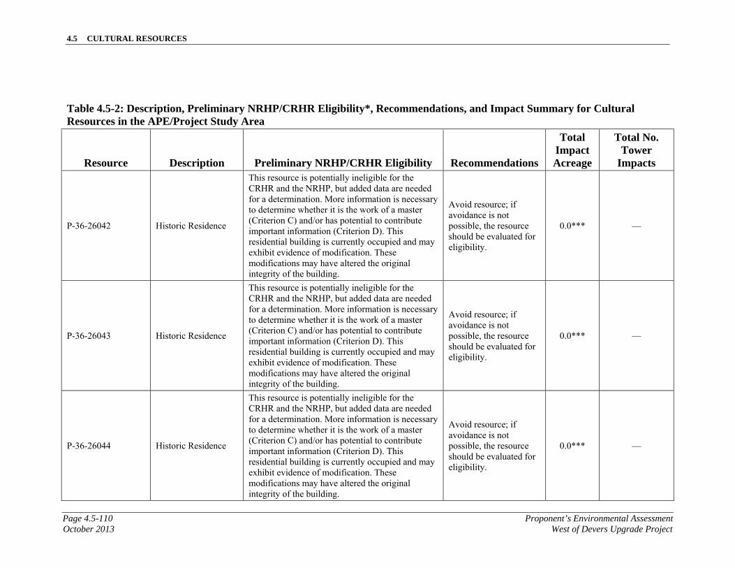
4.5 CULTURAL RESOURCES
Page 4.5-110 Proponent’s Environmental AssessmentOctober 2013 West of Devers Upgrade Project
Table 4.5-2: Description, Preliminary NRHP/CRHR Eligibility*, Recommendations, and Impact Summary for Cultural Resources in the APE/Project Study Area
Resource Description Preliminary NRHP/CRHR Eligibility Recommendations
Total Impact Acreage
Total No. Tower
Impacts
P-36-26042 Historic Residence
This resource is potentially ineligible for the CRHR and the NRHP, but added data are needed for a determination. More information is necessary to determine whether it is the work of a master (Criterion C) and/or has potential to contribute important information (Criterion D). This residential building is currently occupied and may exhibit evidence of modification. These modifications may have altered the original integrity of the building.
Avoid resource; if avoidance is not possible, the resource should be evaluated for eligibility.
0.0*** —
P-36-26043 Historic Residence
This resource is potentially ineligible for the CRHR and the NRHP, but added data are needed for a determination. More information is necessary to determine whether it is the work of a master (Criterion C) and/or has potential to contribute important information (Criterion D). This residential building is currently occupied and may exhibit evidence of modification. These modifications may have altered the original integrity of the building.
Avoid resource; if avoidance is not possible, the resource should be evaluated for eligibility.
0.0*** —
P-36-26044 Historic Residence
This resource is potentially ineligible for the CRHR and the NRHP, but added data are needed for a determination. More information is necessary to determine whether it is the work of a master (Criterion C) and/or has potential to contribute important information (Criterion D). This residential building is currently occupied and may exhibit evidence of modification. These modifications may have altered the original integrity of the building.
Avoid resource; if avoidance is not possible, the resource should be evaluated for eligibility.
0.0*** —
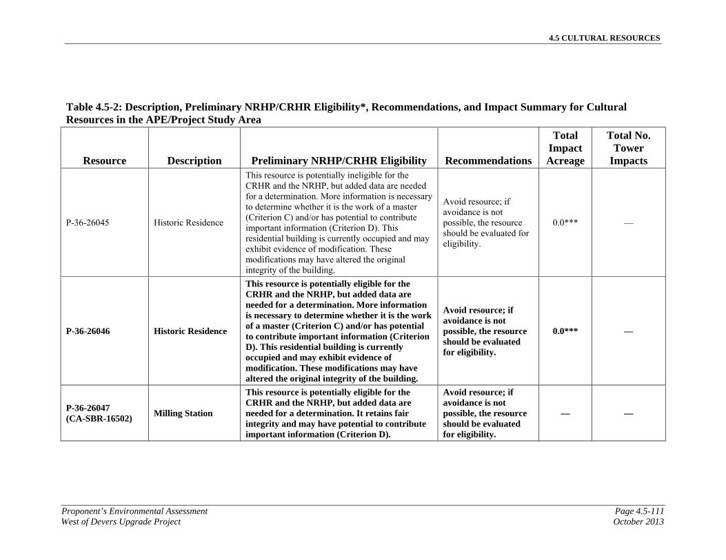
4.5 CULTURAL RESOURCES
Proponent’s Environmental Assessment Page 4.5-111West of Devers Upgrade Project October 2013
Table 4.5-2: Description, Preliminary NRHP/CRHR Eligibility*, Recommendations, and Impact Summary for Cultural Resources in the APE/Project Study Area
Resource Description Preliminary NRHP/CRHR Eligibility Recommendations
Total Impact Acreage
Total No. Tower
Impacts
P-36-26045 Historic Residence
This resource is potentially ineligible for the CRHR and the NRHP, but added data are needed for a determination. More information is necessary to determine whether it is the work of a master (Criterion C) and/or has potential to contribute important information (Criterion D). This residential building is currently occupied and may exhibit evidence of modification. These modifications may have altered the original integrity of the building.
Avoid resource; if avoidance is not possible, the resource should be evaluated for eligibility.
0.0*** —
P-36-26046 Historic Residence
This resource is potentially eligible for the CRHR and the NRHP, but added data are needed for a determination. More information is necessary to determine whether it is the work of a master (Criterion C) and/or has potential to contribute important information (Criterion D). This residential building is currently occupied and may exhibit evidence of modification. These modifications may have altered the original integrity of the building.
Avoid resource; if avoidance is not possible, the resource should be evaluated for eligibility.
0.0*** —
P-36-26047 (CA-SBR-16502)
Milling Station
This resource is potentially eligible for the CRHR and the NRHP, but added data are needed for a determination. It retains fair integrity and may have potential to contribute important information (Criterion D).
Avoid resource; if avoidance is not possible, the resource should be evaluated for eligibility.
— —
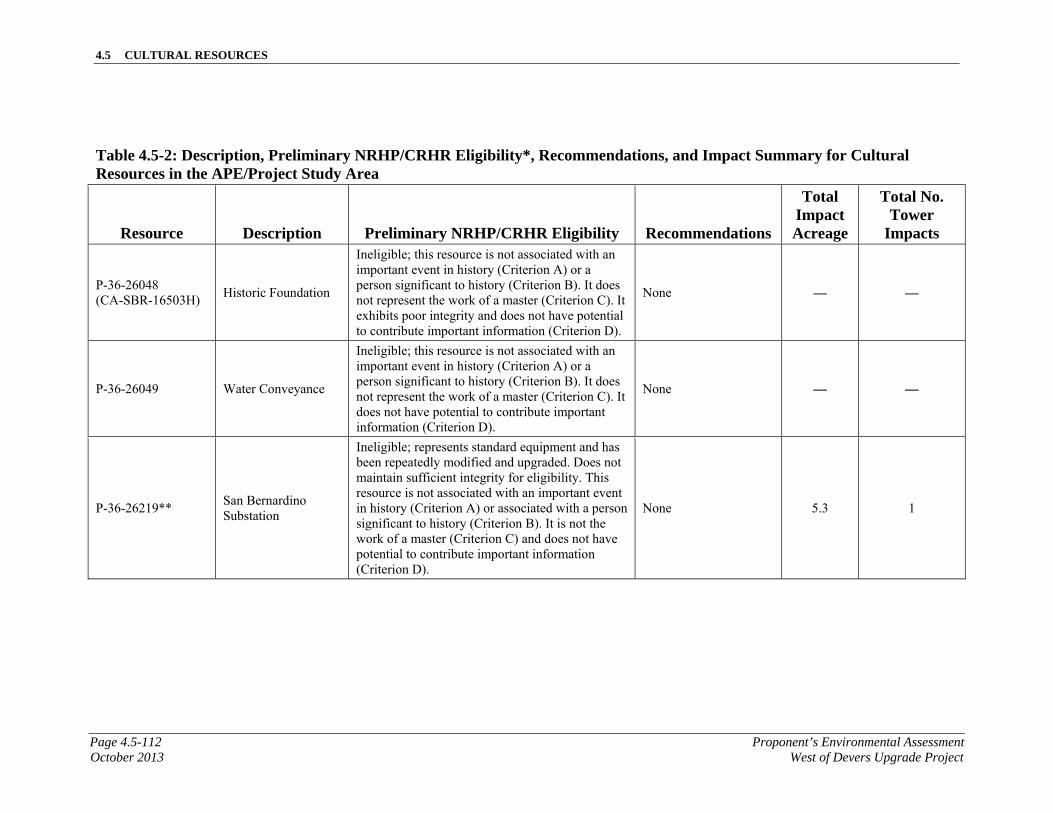
4.5 CULTURAL RESOURCES
Page 4.5-112 Proponent’s Environmental AssessmentOctober 2013 West of Devers Upgrade Project
Table 4.5-2: Description, Preliminary NRHP/CRHR Eligibility*, Recommendations, and Impact Summary for Cultural Resources in the APE/Project Study Area
Resource Description Preliminary NRHP/CRHR Eligibility Recommendations
Total Impact Acreage
Total No. Tower
Impacts
P-36-26048 (CA-SBR-16503H)
Historic Foundation
Ineligible; this resource is not associated with an important event in history (Criterion A) or a person significant to history (Criterion B). It does not represent the work of a master (Criterion C). It exhibits poor integrity and does not have potential to contribute important information (Criterion D).
None — —
P-36-26049 Water Conveyance
Ineligible; this resource is not associated with an important event in history (Criterion A) or a person significant to history (Criterion B). It does not represent the work of a master (Criterion C). It does not have potential to contribute important information (Criterion D).
None — —
P-36-26219** San Bernardino Substation
Ineligible; represents standard equipment and has been repeatedly modified and upgraded. Does not maintain sufficient integrity for eligibility. This resource is not associated with an important event in history (Criterion A) or associated with a person significant to history (Criterion B). It is not the work of a master (Criterion C) and does not have potential to contribute important information (Criterion D).
None 5.3 1
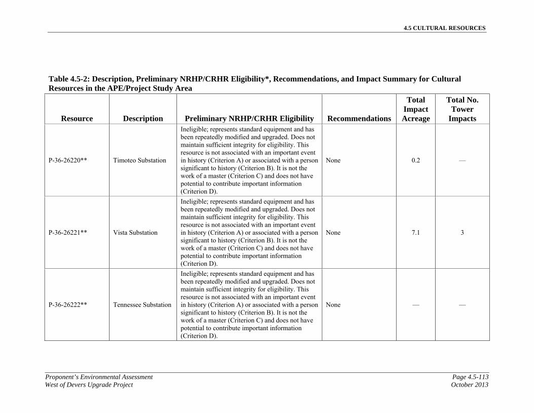
4.5 CULTURAL RESOURCES
Proponent’s Environmental Assessment Page 4.5-113West of Devers Upgrade Project October 2013
Table 4.5-2: Description, Preliminary NRHP/CRHR Eligibility*, Recommendations, and Impact Summary for Cultural Resources in the APE/Project Study Area
Resource Description Preliminary NRHP/CRHR Eligibility Recommendations
Total Impact Acreage
Total No. Tower
Impacts
P-36-26220** Timoteo Substation
Ineligible; represents standard equipment and has been repeatedly modified and upgraded. Does not maintain sufficient integrity for eligibility. This resource is not associated with an important event in history (Criterion A) or associated with a person significant to history (Criterion B). It is not the work of a master (Criterion C) and does not have potential to contribute important information (Criterion D).
None 0.2 —
P-36-26221** Vista Substation
Ineligible; represents standard equipment and has been repeatedly modified and upgraded. Does not maintain sufficient integrity for eligibility. This resource is not associated with an important event in history (Criterion A) or associated with a person significant to history (Criterion B). It is not the work of a master (Criterion C) and does not have potential to contribute important information (Criterion D).
None 7.1 3
P-36-26222** Tennessee Substation
Ineligible; represents standard equipment and has been repeatedly modified and upgraded. Does not maintain sufficient integrity for eligibility. This resource is not associated with an important event in history (Criterion A) or associated with a person significant to history (Criterion B). It is not the work of a master (Criterion C) and does not have potential to contribute important information (Criterion D).
None — —
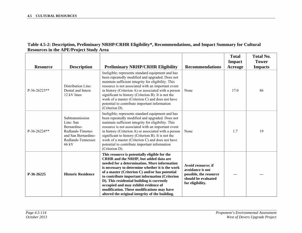
4.5 CULTURAL RESOURCES
Page 4.5-114 Proponent’s Environmental AssessmentOctober 2013 West of Devers Upgrade Project
Table 4.5-2: Description, Preliminary NRHP/CRHR Eligibility*, Recommendations, and Impact Summary for Cultural Resources in the APE/Project Study Area
Resource Description Preliminary NRHP/CRHR Eligibility Recommendations
Total Impact Acreage
Total No. Tower
Impacts
P-36-26223** Distribution Line: Dental and Intern 12 kV lines
Ineligible; represents standard equipment and has been repeatedly modified and upgraded. Does not maintain sufficient integrity for eligibility. This resource is not associated with an important event in history (Criterion A) or associated with a person significant to history (Criterion B). It is not the work of a master (Criterion C) and does not have potential to contribute important information (Criterion D).
None 17.0 86
P-36-26224**
Subtransmission Line: San Bernardino-Redlands-Timoteo and San Bernardino-Redlands-Tennessee 66 kV
Ineligible; represents standard equipment and has been repeatedly modified and upgraded. Does not maintain sufficient integrity for eligibility. This resource is not associated with an important event in history (Criterion A) or associated with a person significant to history (Criterion B). It is not the work of a master (Criterion C) and does not have potential to contribute important information (Criterion D).
None 1.7 19
P-36-26225 Historic Residence
This resource is potentially eligible for the CRHR and the NRHP, but added data are needed for a determination. More information is necessary to determine whether it is the work of a master (Criterion C) and/or has potential to contribute important information (Criterion D). This residential building is currently occupied and may exhibit evidence of modification. These modifications may have altered the original integrity of the building.
Avoid resource; if avoidance is not possible, the resource should be evaluated for eligibility.
— —
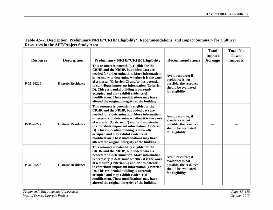
4.5 CULTURAL RESOURCES
Proponent’s Environmental Assessment Page 4.5-115West of Devers Upgrade Project October 2013
Table 4.5-2: Description, Preliminary NRHP/CRHR Eligibility*, Recommendations, and Impact Summary for Cultural Resources in the APE/Project Study Area
Resource Description Preliminary NRHP/CRHR Eligibility Recommendations
Total Impact Acreage
Total No. Tower
Impacts
P-36-26226 Historic Residence
This resource is potentially eligible for the CRHR and the NRHP, but added data are needed for a determination. More information is necessary to determine whether it is the work of a master (Criterion C) and/or has potential to contribute important information (Criterion D). This residential building is currently occupied and may exhibit evidence of modification. These modifications may have altered the original integrity of the building.
Avoid resource; if avoidance is not possible, the resource should be evaluated for eligibility.
— —
P-36-26227 Historic Residence
This resource is potentially eligible for the CRHR and the NRHP, but added data are needed for a determination. More information is necessary to determine whether it is the work of a master (Criterion C) and/or has potential to contribute important information (Criterion D). This residential building is currently occupied and may exhibit evidence of modification. These modifications may have altered the original integrity of the building.
Avoid resource; if avoidance is not possible, the resource should be evaluated for eligibility.
— —
P-36-26228 Historic Residence
This resource is potentially eligible for the CRHR and the NRHP, but added data are needed for a determination. More information is necessary to determine whether it is the work of a master (Criterion C) and/or has potential to contribute important information (Criterion D). This residential building is currently occupied and may exhibit evidence of modification. These modifications may have altered the original integrity of the building.
Avoid resource; if avoidance is not possible, the resource should be evaluated for eligibility.
— —
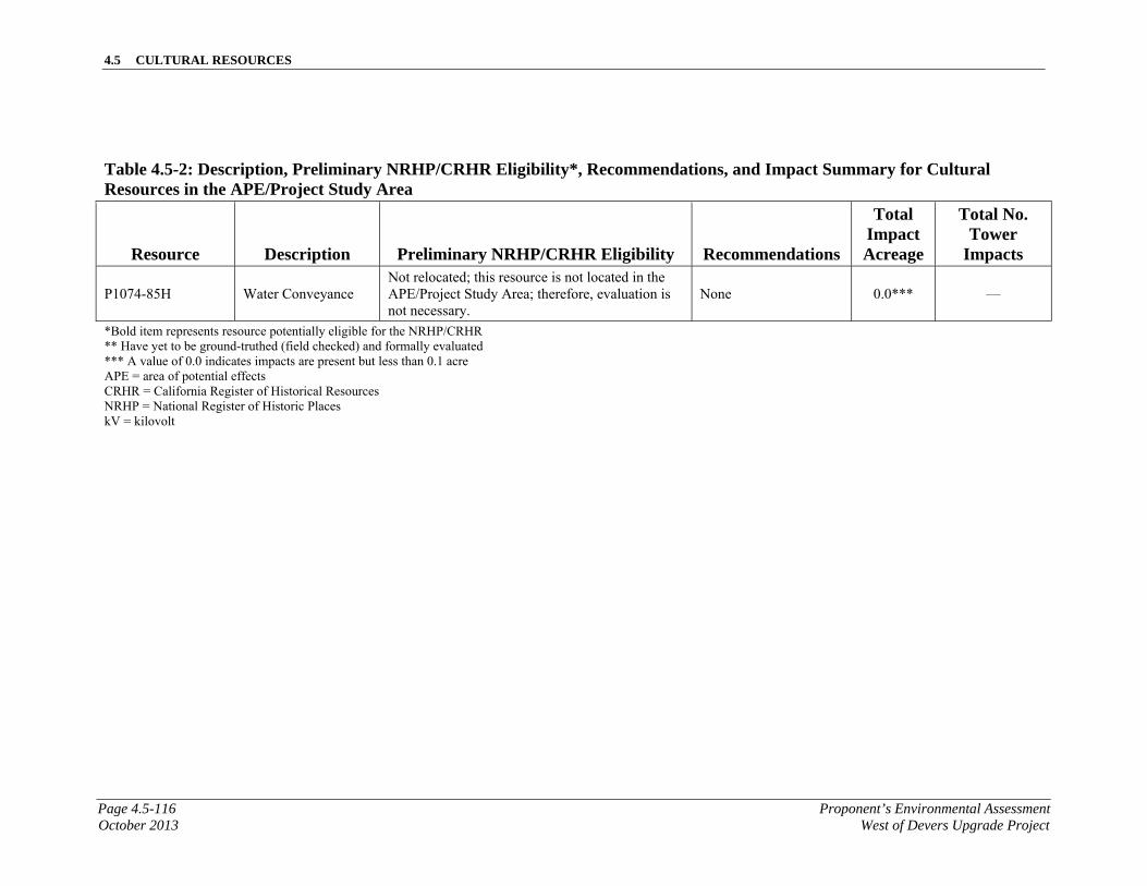
4.5 CULTURAL RESOURCES
Page 4.5-116 Proponent’s Environmental AssessmentOctober 2013 West of Devers Upgrade Project
Table 4.5-2: Description, Preliminary NRHP/CRHR Eligibility*, Recommendations, and Impact Summary for Cultural Resources in the APE/Project Study Area
Resource Description Preliminary NRHP/CRHR Eligibility Recommendations
Total Impact Acreage
Total No. Tower
Impacts
P1074-85H Water Conveyance Not relocated; this resource is not located in the APE/Project Study Area; therefore, evaluation is not necessary.
None 0.0*** —
*Bold item represents resource potentially eligible for the NRHP/CRHR ** Have yet to be ground-truthed (field checked) and formally evaluated *** A value of 0.0 indicates impacts are present but less than 0.1 acre APE = area of potential effects CRHR = California Register of Historical Resources NRHP = National Register of Historic Places kV = kilovolt
4.5 CULTURAL RESOURCES
Proponent’s Environmental Assessment Page 4.5-117West of Devers Upgrade Project October 2013
4.5.4.1 CEQA Impact Assessment
Would the project cause a substantial adverse change in the significance of a historical resource as defined in Section 15064.5?
The following discussion addresses all Proposed Project components, including substation modifications, 220 kV transmission lines, 66 kV subtransmission lines, 12 kV distribution lines, telecommunication facilities, and the establishment of staging yards.
Construction Impacts
Construction of the Proposed Project has the potential to affect cultural resources. A provisional assessment of impacts can be based on the currently available level of engineering design and preliminary evaluations of resource eligibility. Upon final design, any unevaluated resources subject to impacts would be evaluated, and impacts to all eligible resources would be further assessed. The 34 cultural resources within the APE/Project Study Area that are or may be eligible for the CRHR are identified, below, by project component. Table 4.5-3, Impact Areas and Tower Impacts for Cultural Resources in the APE/Project Study Area, shows all impacts to resources within the APE/Project Study Area by type of impact. Impacts are described as either permanent or temporary. A permanent impact is substantial and results from the construction and/or operation of long-term project improvements. A temporary impact is minor and results from short-term activities, such as work area access or wire-pulling, although ground disturbance within the limits of a cultural resource could have the potential for causing permanent damage.
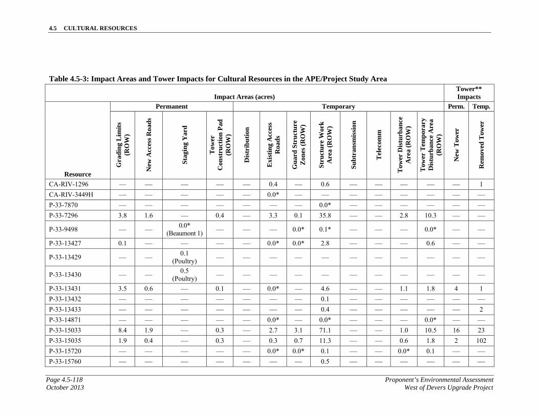
4.5 CULTURAL RESOURCES
Page 4.5-118 Proponent’s Environmental AssessmentOctober 2013 West of Devers Upgrade Project
Table 4.5-3: Impact Areas and Tower Impacts for Cultural Resources in the APE/Project Study Area
Impact Areas (acres) Tower** Impacts
Resource
Permanent Temporary Perm. Temp.
Gra
din
g L
imit
s (R
OW
)
New
Acc
ess
Roa
ds
Sta
ging
Yar
d
Tow
er
Con
stru
ctio
n P
ad
(RO
W)
Dis
trib
utio
n
Exi
stin
g A
cces
s R
oad
s
Gu
ard
Str
uct
ure
Z
ones
(R
OW
)
Str
uct
ure
Wor
k
Are
a (R
OW
)
Su
btr
ansm
issi
on
Tel
ecom
m
Tow
er D
istu
rban
ce
Are
a (R
OW
)
Tow
er T
empo
rary
D
istu
rban
ce A
rea
(RO
W)
New
Tow
er
Rem
oved
Tow
er
CA-RIV-1296 — — — — — 0.4 — 0.6 — — — — — 1
CA-RIV-3449H — — — — — 0.0* — — — — — — — —
P-33-7870 — — — — — — — 0.0* — — — — — — P-33-7296 3.8 1.6 — 0.4 — 3.3 0.1 35.8 — — 2.8 10.3 — —
P-33-9498 — — 0.0*
(Beaumont 1) — — — 0.0* 0.1* — — — 0.0* — —
P-33-13427 0.1 — — — — 0.0* 0.0* 2.8 — — — 0.6 — —
P-33-13429 — — 0.1
(Poultry) — — — — — — — — — — —
P-33-13430 — — 0.5
(Poultry) — — — — — — — — — — —
P-33-13431 3.5 0.6 — 0.1 — 0.0* — 4.6 — — 1.1 1.8 4 1
P-33-13432 — — — — — — — 0.1 — — — — — —
P-33-13433 — — — — — — — 0.4 — — — — — 2
P-33-14871 — — — — — 0.0* — 0.0* — — — 0.0* — —
P-33-15033 8.4 1.9 — 0.3 — 2.7 3.1 71.1 — — 1.0 10.5 16 23
P-33-15035 1.9 0.4 — 0.3 — 0.3 0.7 11.3 — — 0.6 1.8 2 102
P-33-15720 — — — — — 0.0* 0.0* 0.1 — — 0.0* 0.1 — —
P-33-15760 — — — — — — — 0.5 — — — — — —
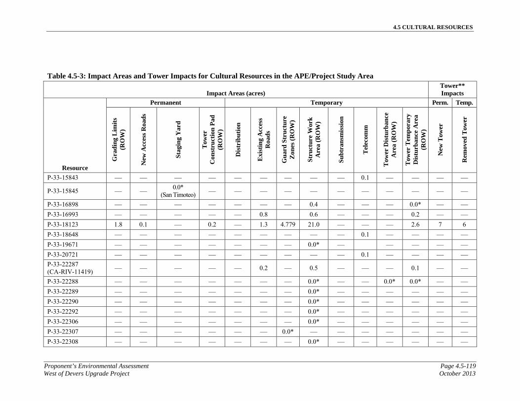
4.5 CULTURAL RESOURCES
Proponent’s Environmental Assessment Page 4.5-119West of Devers Upgrade Project October 2013
Table 4.5-3: Impact Areas and Tower Impacts for Cultural Resources in the APE/Project Study Area
Impact Areas (acres) Tower** Impacts
Resource
Permanent Temporary Perm. Temp.
Gra
din
g L
imit
s (R
OW
)
New
Acc
ess
Roa
ds
Sta
ging
Yar
d
Tow
er
Con
stru
ctio
n P
ad
(RO
W)
Dis
trib
utio
n
Exi
stin
g A
cces
s R
oad
s
Gu
ard
Str
uct
ure
Z
ones
(R
OW
)
Str
uct
ure
Wor
k
Are
a (R
OW
)
Su
btr
ansm
issi
on
Tel
ecom
m
Tow
er D
istu
rban
ce
Are
a (R
OW
)
Tow
er T
empo
rary
D
istu
rban
ce A
rea
(RO
W)
New
Tow
er
Rem
oved
Tow
er
P-33-15843 — — — — — — — — — 0.1 — — — —
P-33-15845 — — 0.0*
(San Timoteo) — — — — — — — — — — —
P-33-16898 — — — — — — — 0.4 — — — 0.0* — —
P-33-16993 — — — — — 0.8 0.6 — — — 0.2 — —
P-33-18123 1.8 0.1 — 0.2 — 1.3 4.779 21.0 — — — 2.6 7 6
P-33-18648 — — — — — — — — — 0.1 — — — —
P-33-19671 — — — — — — — 0.0* — — — — —
P-33-20721 — — — — — — — — — 0.1 — — — —
P-33-22287 (CA-RIV-11419) — — — — — 0.2 — 0.5 — — — 0.1 — —
P-33-22288 — — — — — — — 0.0* — — 0.0* 0.0* — —
P-33-22289 — — — — — — — 0.0* — — — — — —
P-33-22290 — — — — — — — 0.0* — — — — — —
P-33-22292 — — — — — — — 0.0* — — — — — —
P-33-22306 — — — — — — — 0.0* — — — — — —
P-33-22307 — — — — — — 0.0* — — — — — — —
P-33-22308 — — — — — — — 0.0* — — — — — —
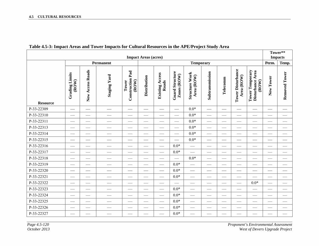
4.5 CULTURAL RESOURCES
Page 4.5-120 Proponent’s Environmental AssessmentOctober 2013 West of Devers Upgrade Project
Table 4.5-3: Impact Areas and Tower Impacts for Cultural Resources in the APE/Project Study Area
Impact Areas (acres) Tower** Impacts
Resource
Permanent Temporary Perm. Temp.
Gra
din
g L
imit
s (R
OW
)
New
Acc
ess
Roa
ds
Sta
ging
Yar
d
Tow
er
Con
stru
ctio
n P
ad
(RO
W)
Dis
trib
utio
n
Exi
stin
g A
cces
s R
oad
s
Gu
ard
Str
uct
ure
Z
ones
(R
OW
)
Str
uct
ure
Wor
k
Are
a (R
OW
)
Su
btr
ansm
issi
on
Tel
ecom
m
Tow
er D
istu
rban
ce
Are
a (R
OW
)
Tow
er T
empo
rary
D
istu
rban
ce A
rea
(RO
W)
New
Tow
er
Rem
oved
Tow
er
P-33-22309 — — — — — — — 0.0* — — — — — —
P-33-22310 — — — — — — — 0.0* — — — — — —
P-33-22311 — — — — — — — 0.0* — — — — — —
P-33-22313 — — — — — — — 0.0* — — — — — —
P-33-22314 — — — — — — — 0.0* — — — — — —
P-33-22315 — — — — — — — 0.0* — — — — — —
P-33-22316 — — — — — — 0.0* — — — — — — —
P-33-22317 — — — — — — 0.0* — — — — — — —
P-33-22318 — — — — — — — 0.0* — — — — — —
P-33-22319 — — — — — — 0.0* — — — — — — —
P-33-22320 — — — — — — 0.0* — — — — — — —
P-33-22321 — — — — — — 0.0* — — — — — — —
P-33-22322 — — — — — — — — — — — 0.0* — —
P-33-22323 — — — — — — 0.0* — — — — — — —
P-33-22324 — — — — — — 0.0* — — — — — — —
P-33-22325 — — — — — — 0.0* — — — — — — —
P-33-22326 — — — — — — 0.0* — — — — — — —
P-33-22327 — — — — — — 0.0* — — — — — — —
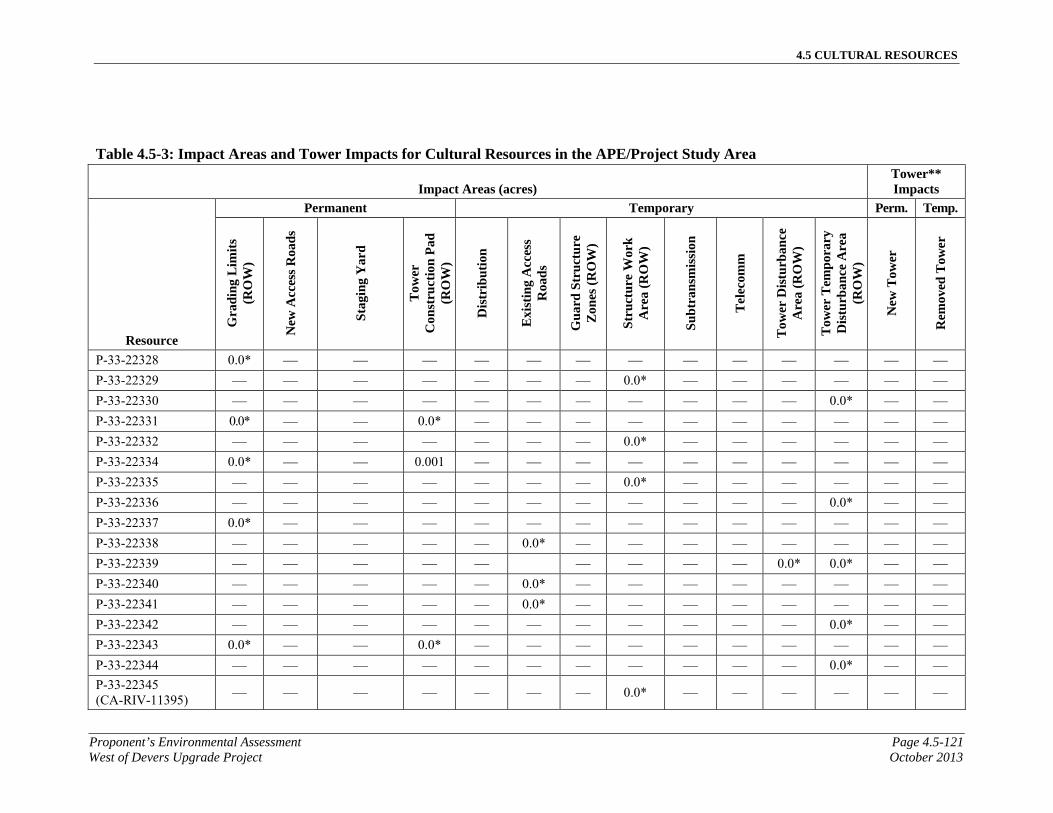
4.5 CULTURAL RESOURCES
Proponent’s Environmental Assessment Page 4.5-121West of Devers Upgrade Project October 2013
Table 4.5-3: Impact Areas and Tower Impacts for Cultural Resources in the APE/Project Study Area
Impact Areas (acres) Tower** Impacts
Resource
Permanent Temporary Perm. Temp.
Gra
din
g L
imit
s (R
OW
)
New
Acc
ess
Roa
ds
Sta
ging
Yar
d
Tow
er
Con
stru
ctio
n P
ad
(RO
W)
Dis
trib
utio
n
Exi
stin
g A
cces
s R
oad
s
Gu
ard
Str
uct
ure
Z
ones
(R
OW
)
Str
uct
ure
Wor
k
Are
a (R
OW
)
Su
btr
ansm
issi
on
Tel
ecom
m
Tow
er D
istu
rban
ce
Are
a (R
OW
)
Tow
er T
empo
rary
D
istu
rban
ce A
rea
(RO
W)
New
Tow
er
Rem
oved
Tow
er
P-33-22328 0.0* — — — — — — — — — — — — —
P-33-22329 — — — — — — — 0.0* — — — — — —
P-33-22330 — — — — — — — — — — — 0.0* — —
P-33-22331 0.0* — — 0.0* — — — — — — — — — —
P-33-22332 — — — — — — — 0.0* — — — — — —
P-33-22334 0.0* — — 0.001 — — — — — — — — — —
P-33-22335 — — — — — — — 0.0* — — — — — —
P-33-22336 — — — — — — — — — — — 0.0* — —
P-33-22337 0.0* — — — — — — — — — — — — —
P-33-22338 — — — — — 0.0* — — — — — — — —
P-33-22339 — — — — — — — — — 0.0* 0.0* — —
P-33-22340 — — — — — 0.0* — — — — — — — —
P-33-22341 — — — — — 0.0* — — — — — — — —
P-33-22342 — — — — — — — — — — — 0.0* — —
P-33-22343 0.0* — — 0.0* — — — — — — — — — —
P-33-22344 — — — — — — — — — — — 0.0* — —
P-33-22345 (CA-RIV-11395) — — — — — — — 0.0* — — — — — —
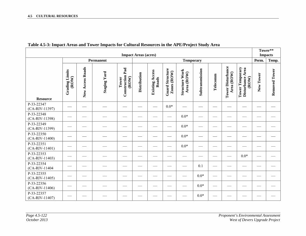
4.5 CULTURAL RESOURCES
Page 4.5-122 Proponent’s Environmental AssessmentOctober 2013 West of Devers Upgrade Project
Table 4.5-3: Impact Areas and Tower Impacts for Cultural Resources in the APE/Project Study Area
Impact Areas (acres) Tower** Impacts
Resource
Permanent Temporary Perm. Temp.
Gra
din
g L
imit
s (R
OW
)
New
Acc
ess
Roa
ds
Sta
ging
Yar
d
Tow
er
Con
stru
ctio
n P
ad
(RO
W)
Dis
trib
utio
n
Exi
stin
g A
cces
s R
oad
s
Gu
ard
Str
uct
ure
Z
ones
(R
OW
)
Str
uct
ure
Wor
k
Are
a (R
OW
)
Su
btr
ansm
issi
on
Tel
ecom
m
Tow
er D
istu
rban
ce
Are
a (R
OW
)
Tow
er T
empo
rary
D
istu
rban
ce A
rea
(RO
W)
New
Tow
er
Rem
oved
Tow
er
P-33-22347 (CA-RIV-11397) — — — — — — 0.0* — — — — — — —
P-33-22348 (CA-RIV-11398) — — — — — — — 0.0* — — — — — —
P-33-22349 (CA-RIV-11399) — — — — — — — 0.0* — — — — — —
P-33-22350 (CA-RIV-11400) — — — — — — — 0.0* — — — — — —
P-33-22351 (CA-RIV-11401) — — — — — — — 0.0* — — — — — —
P-33-22353 (CA-RIV-11403) — — — — — — — — — — — 0.0* — —
P-33-22354 (CA-RIV-11404 — — — — — — — — 0.1 — — — — —
P-33-22355 (CA-RIV-11405) — — — — — — — — 0.0* — — — — —
P-33-22356 (CA-RIV-11406) — — — — — — — — 0.0* — — — — —
P-33-22357 (CA-RIV-11407) — — — — — — — — 0.0* — — — — —
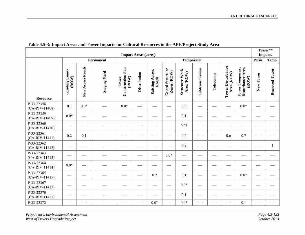
4.5 CULTURAL RESOURCES
Proponent’s Environmental Assessment Page 4.5-123West of Devers Upgrade Project October 2013
Table 4.5-3: Impact Areas and Tower Impacts for Cultural Resources in the APE/Project Study Area
Impact Areas (acres) Tower** Impacts
Resource
Permanent Temporary Perm. Temp.
Gra
din
g L
imit
s (R
OW
)
New
Acc
ess
Roa
ds
Sta
ging
Yar
d
Tow
er
Con
stru
ctio
n P
ad
(RO
W)
Dis
trib
utio
n
Exi
stin
g A
cces
s R
oad
s
Gu
ard
Str
uct
ure
Z
ones
(R
OW
)
Str
uct
ure
Wor
k
Are
a (R
OW
)
Su
btr
ansm
issi
on
Tel
ecom
m
Tow
er D
istu
rban
ce
Are
a (R
OW
)
Tow
er T
empo
rary
D
istu
rban
ce A
rea
(RO
W)
New
Tow
er
Rem
oved
Tow
er
P-33-22358 (CA-RIV-11408)
0.1 0.0* — 0.0* — — — 0.3 — — — 0.0* — —
P-33-22359 (CA-RIV-11409)
0.0* — — — — — — 0.1 — — — — — —
P-33-22360 (CA-RIV-11410) — — — — — — — 0.0* — — — — — —
P-33-22361 (CA-RIV-11411)
0.2 0.1 — — — — — 0.4 — — 0.6 0.7 — —
P-33-22362 (CA-RIV-11412) — — — — — — — 0.9 — — — — — 1
P-33-22363 (CA-RIV-11413) — — — — — — 0.0* — — — — — — —
P-33-22364 (CA-RIV-11414)
0.0* — — — — — — — — — — — — —
P-33-22365 (CA-RIV-11415) — — — — — 0.2 — 0.1 — — — 0.0* — —
P-33-22367 (CA-RIV-11417) — — — — — — — 0.0* — — — — — —
P-33-22370 (CA-RIV-11421) — — — — — — — 0.1 — — — — — —
P-33-22372 — — — — — 0.0* — 0.0* — — — 0.1 — —
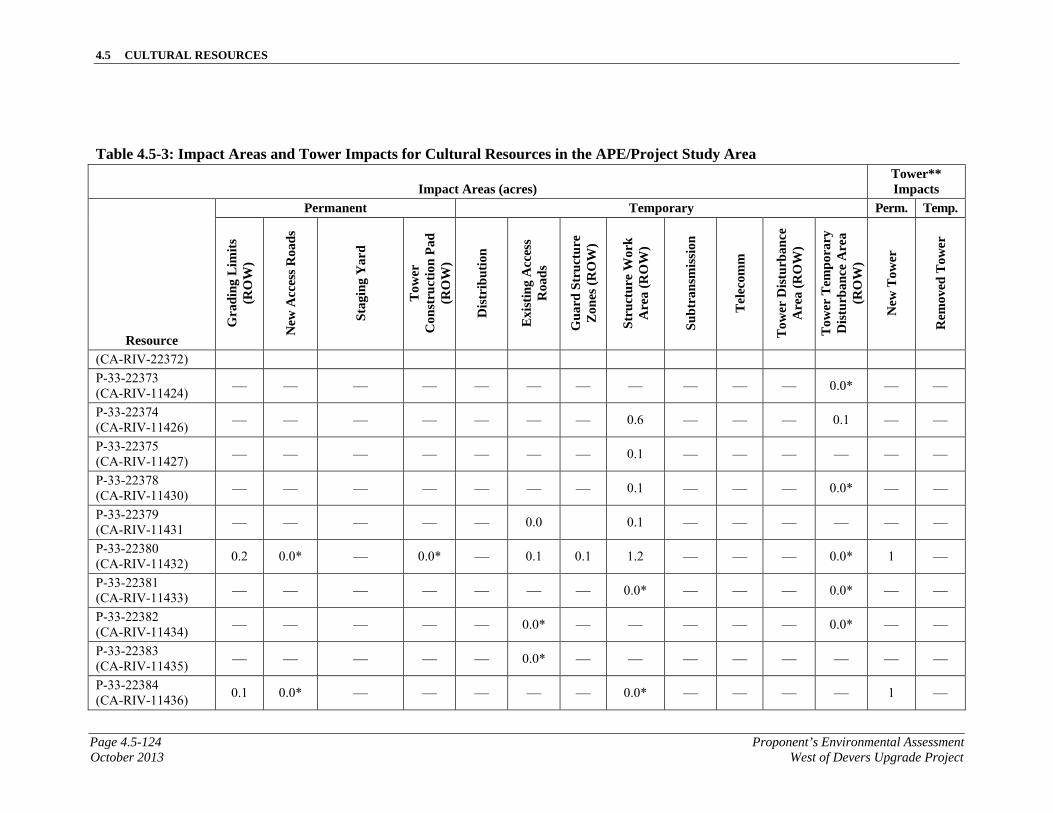
4.5 CULTURAL RESOURCES
Page 4.5-124 Proponent’s Environmental AssessmentOctober 2013 West of Devers Upgrade Project
Table 4.5-3: Impact Areas and Tower Impacts for Cultural Resources in the APE/Project Study Area
Impact Areas (acres) Tower** Impacts
Resource
Permanent Temporary Perm. Temp.
Gra
din
g L
imit
s (R
OW
)
New
Acc
ess
Roa
ds
Sta
ging
Yar
d
Tow
er
Con
stru
ctio
n P
ad
(RO
W)
Dis
trib
utio
n
Exi
stin
g A
cces
s R
oad
s
Gu
ard
Str
uct
ure
Z
ones
(R
OW
)
Str
uct
ure
Wor
k
Are
a (R
OW
)
Su
btr
ansm
issi
on
Tel
ecom
m
Tow
er D
istu
rban
ce
Are
a (R
OW
)
Tow
er T
empo
rary
D
istu
rban
ce A
rea
(RO
W)
New
Tow
er
Rem
oved
Tow
er
(CA-RIV-22372)
P-33-22373 (CA-RIV-11424) — — — — — — — — — — — 0.0* — —
P-33-22374 (CA-RIV-11426) — — — — — — — 0.6 — — — 0.1 — —
P-33-22375 (CA-RIV-11427) — — — — — — — 0.1 — — — — — —
P-33-22378 (CA-RIV-11430) — — — — — — — 0.1 — — — 0.0* — —
P-33-22379 (CA-RIV-11431 — — — — — 0.0 0.1 — — — — — —
P-33-22380 (CA-RIV-11432)
0.2 0.0* — 0.0* — 0.1 0.1 1.2 — — — 0.0* 1 —
P-33-22381 (CA-RIV-11433) — — — — — — — 0.0* — — — 0.0* — —
P-33-22382 (CA-RIV-11434) — — — — — 0.0* — — — — — 0.0* — —
P-33-22383 (CA-RIV-11435) — — — — — 0.0* — — — — — — — —
P-33-22384 (CA-RIV-11436)
0.1 0.0* — — — — — 0.0* — — — — 1 —
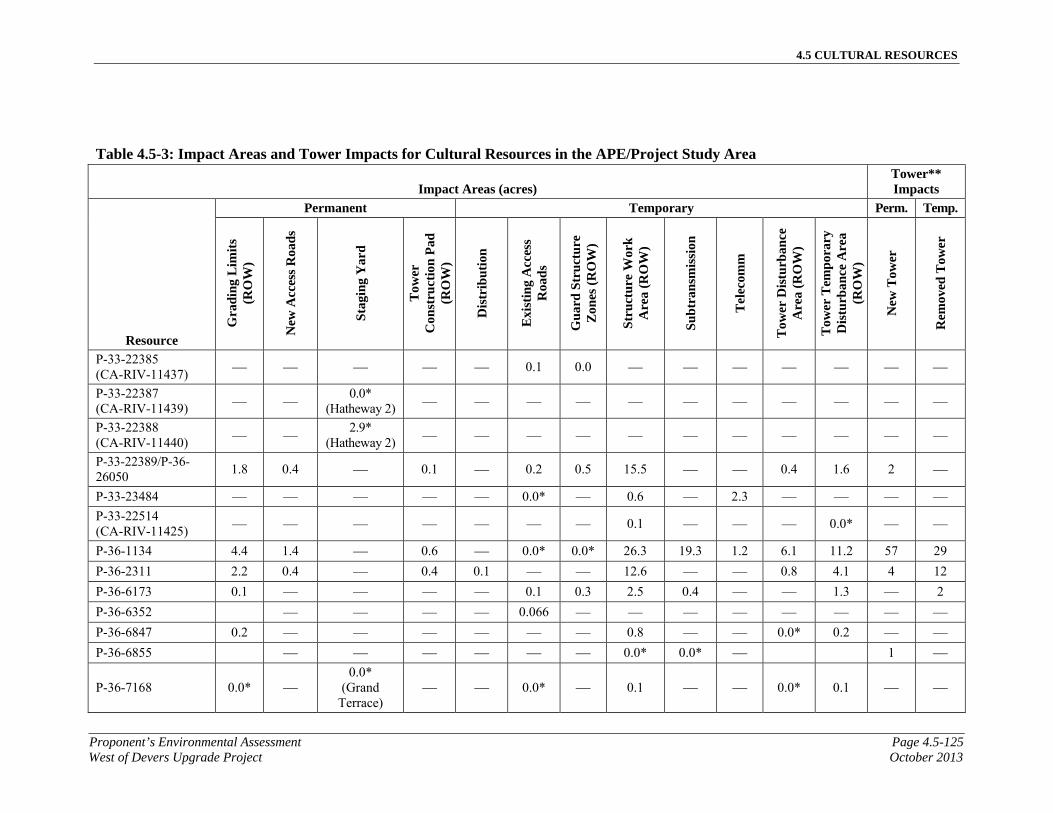
4.5 CULTURAL RESOURCES
Proponent’s Environmental Assessment Page 4.5-125West of Devers Upgrade Project October 2013
Table 4.5-3: Impact Areas and Tower Impacts for Cultural Resources in the APE/Project Study Area
Impact Areas (acres) Tower** Impacts
Resource
Permanent Temporary Perm. Temp.
Gra
din
g L
imit
s (R
OW
)
New
Acc
ess
Roa
ds
Sta
ging
Yar
d
Tow
er
Con
stru
ctio
n P
ad
(RO
W)
Dis
trib
utio
n
Exi
stin
g A
cces
s R
oad
s
Gu
ard
Str
uct
ure
Z
ones
(R
OW
)
Str
uct
ure
Wor
k
Are
a (R
OW
)
Su
btr
ansm
issi
on
Tel
ecom
m
Tow
er D
istu
rban
ce
Are
a (R
OW
)
Tow
er T
empo
rary
D
istu
rban
ce A
rea
(RO
W)
New
Tow
er
Rem
oved
Tow
er
P-33-22385 (CA-RIV-11437) — — — — — 0.1 0.0 — — — — — — —
P-33-22387 (CA-RIV-11439) — —
0.0* (Hatheway 2) — — — — — — — — — — —
P-33-22388 (CA-RIV-11440) — —
2.9* (Hatheway 2) — — — — — — — — — — —
P-33-22389/P-36-26050
1.8 0.4 — 0.1 — 0.2 0.5 15.5 — — 0.4 1.6 2 —
P-33-23484 — — — — — 0.0* — 0.6 — 2.3 — — — —
P-33-22514 (CA-RIV-11425) — — — — — — — 0.1 — — — 0.0* — —
P-36-1134 4.4 1.4 — 0.6 — 0.0* 0.0* 26.3 19.3 1.2 6.1 11.2 57 29
P-36-2311 2.2 0.4 — 0.4 0.1 — — 12.6 — — 0.8 4.1 4 12
P-36-6173 0.1 — — — — 0.1 0.3 2.5 0.4 — — 1.3 — 2
P-36-6352 — — — — 0.066 — — — — — — — —
P-36-6847 0.2 — — — — — — 0.8 — — 0.0* 0.2 — —
P-36-6855 — — — — — — 0.0* 0.0* — 1 —
P-36-7168 0.0* — 0.0*
(Grand Terrace)
— — 0.0* — 0.1 — — 0.0* 0.1 — —

4.5 CULTURAL RESOURCES
Page 4.5-126 Proponent’s Environmental AssessmentOctober 2013 West of Devers Upgrade Project
Table 4.5-3: Impact Areas and Tower Impacts for Cultural Resources in the APE/Project Study Area
Impact Areas (acres) Tower** Impacts
Resource
Permanent Temporary Perm. Temp.
Gra
din
g L
imit
s (R
OW
)
New
Acc
ess
Roa
ds
Sta
ging
Yar
d
Tow
er
Con
stru
ctio
n P
ad
(RO
W)
Dis
trib
utio
n
Exi
stin
g A
cces
s R
oad
s
Gu
ard
Str
uct
ure
Z
ones
(R
OW
)
Str
uct
ure
Wor
k
Are
a (R
OW
)
Su
btr
ansm
issi
on
Tel
ecom
m
Tow
er D
istu
rban
ce
Are
a (R
OW
)
Tow
er T
empo
rary
D
istu
rban
ce A
rea
(RO
W)
New
Tow
er
Rem
oved
Tow
er
P-36-10330 0.0* — — — — 0.4 — 0.7 0.0* — — 0.2 — 1
P-36-11624 — — — — 0.2 — 0.7 — — — 0.0 — —
P-36-12365 0.2 — — — — — — 1.2 — — — 0.3 — —
P-36-13889 — — — — — — — 0.3 — — — — — —
P-36-13891 — — — 0.0* — — 1.2 — — — 0.3 — —
P-36-20240 0.0* — — 0.0* — — — — — — — — — —
P-36-24295 — — — — — — 0.6 — — — — 1 1
P-36-25603 — — — — — — — — — — 0.0* — —
P-36-26031 (CA-SBR-16501H) — —
0.8 (Mountain View 1)
— — — — — — — — — — —
P-36-26032 — — — — — — — — — — 0.0* 0.0* — —
P-36-26033 — — — — — — — — — — — 0.0* — —
P-36-26034 0.0* — — — — — — 0.1 — — — — — —
P-36-26035 — — — — — — — 0.0* — — — — — —
P-36-26036 — — — — — — — 0.1 — — — — — —
P-36-26037 — — — — — — — 0.1 — — — — — —
P-36-26038 — — — — — — — 0.1 — — — — — —

4.5 CULTURAL RESOURCES
Proponent’s Environmental Assessment Page 4.5-127West of Devers Upgrade Project October 2013
Table 4.5-3: Impact Areas and Tower Impacts for Cultural Resources in the APE/Project Study Area
Impact Areas (acres) Tower** Impacts
Resource
Permanent Temporary Perm. Temp.
Gra
din
g L
imit
s (R
OW
)
New
Acc
ess
Roa
ds
Sta
ging
Yar
d
Tow
er
Con
stru
ctio
n P
ad
(RO
W)
Dis
trib
utio
n
Exi
stin
g A
cces
s R
oad
s
Gu
ard
Str
uct
ure
Z
ones
(R
OW
)
Str
uct
ure
Wor
k
Are
a (R
OW
)
Su
btr
ansm
issi
on
Tel
ecom
m
Tow
er D
istu
rban
ce
Are
a (R
OW
)
Tow
er T
empo
rary
D
istu
rban
ce A
rea
(RO
W)
New
Tow
er
Rem
oved
Tow
er
P-36-26039 — — — — — — — 0.0* — — — 0.0* — —
P-36-26040 — — — — — — — — — — — 0.0* — —
P-36-26041 — — — — — — — — — — — 0.0* — —
P-36-26042 — — — — — — — — — — — 0.0* — —
P-36-26044 — — — — — — — — — — — 0.0* — —
P-36-26044 — — — — — — — 0.0* — — — 0.0* — —
P-36-26045 — — — — — — — — — — — 0.0* — —
P-36-26046 — — — — — — — 0.0* — — — 0.0* — —
P-36-26219 0.1 — — — — — — 3.0 — 1.2 0.1 0.9 1 —
P-36-26220 — — — — — — — — 0.2 — — — — —
P-36-26221 0.9 — — 0.1 — — — 4.5 — 0.4 0.0* 1.2 2 1
P-36-26223 — — — — 0.0* — — 0.7 16.1 0.0* 0.0* 0.1 65 21
P-36-26224 0.3 0.1 — 0.0* — 0.0* 0.0* 0.9 0.0* — 0.1 0.1 — 19
P1074-85H 0.0* — — 0.0* — — — 0.0* — — — 0.0* 8 6
Grand Total 28.9 6.9 4.4 2.3 0.1 11.1 9.8 214.2 20.0 1.5 13.5 48.4 104 185 * A value of 0.0 indicates impacts are present but less than 0.1 acres ** Tower refers to LSTs and TSPs

4.5 CULTURAL RESOURCES
Page 4.5-128 Proponent’s Environmental AssessmentOctober 2013 West of Devers Upgrade Project
Substation Modifications. There are no new substations proposed as part of the Proposed Project. Modifications to existing substation equipment would be performed to accommodate continuous and emergency power on the 220 kilovolt (kV) transmission lines between Vista, San Bernardino, El Casco, Etiwanda, and Devers substations. Additionally, modifications to Timoteo and Tennessee substations would also be performed to accommodate the 66 kV subtransmission line relocations. All substation-related work would be conducted within the existing substation walls or fence lines.
San Bernardino Substation (P-36-26219), Timoteo Substation (P-36-26220), Vista Substation (P-36-26221), Tennessee Substation (P-36-26222), and Banning Substation (P-33-15843) are historic in age. These are electrical substations built by SCE between 1940 and the late 1960s. They were built to accommodate the increase in utility usage that resulted from the residential and commercial booms that occurred throughout southern California following WWII. The substations are not recommended eligible for listing in the NRHP or to be historical resources for the purposes of CEQA. Although they are associated with the post-WWII development of southern California, they are not important examples of that significant event (Criteria A/1). The substations are not associated with any persons important to history (Criteria B/2). The substations are utilitarian in design and are a common resource type. Other than the Timoteo Substation, which is in fair condition and retains integrity, the remaining substations have been modified and upgraded extensively. They do not possess high artistic value and they are not the work of a master (Criteria C/3). Finally, the substations do not appear to be able to answer questions important to history (Criteria D/4).
No cultural resources that are potentially eligible for the CRHR are located within the substations component of the Proposed Project.
220 kV Transmission Lines. The Proposed Project would include the removal and upgrade of approximately 181 circuit miles of existing 220 kV transmission line facilities (approximately 48 corridor miles) primarily within existing WOD corridor. The Proposed Project would primarily be constructed on a combination of new 220 kV double-circuit lattice steel towers (LSTs), double-circuit tubular steel poles (TSPs), and single-phase TSPs. Each of the proposed 220 kV transmission lines would consist of overhead wires (conductors).
Access and spur roads would be used to access the planned removal and construction areas. SCE’s existing access roads are located within SCE ROW/easements. New and/or expanded property rights may be required to construct new access/spur roads.
Temporary wood and/or steel structures would be used to facilitate construction of the new 220 kV transmission lines, and would function as guard structures and/or shoo-fly structures. These temporary structures would be direct-buried and/or guyed and removed following completion of construction for the particular location.
Two of the existing 220 kV transmission lines have been recorded as cultural resources (P-33-15035/P-36-26051 and P-33-22389/P-36-26050) but recommended as ineligible for listing in the NRHP or CRHR. The transmission lines include typical and standard pole design and technology, and have been continuously upgraded and modified,
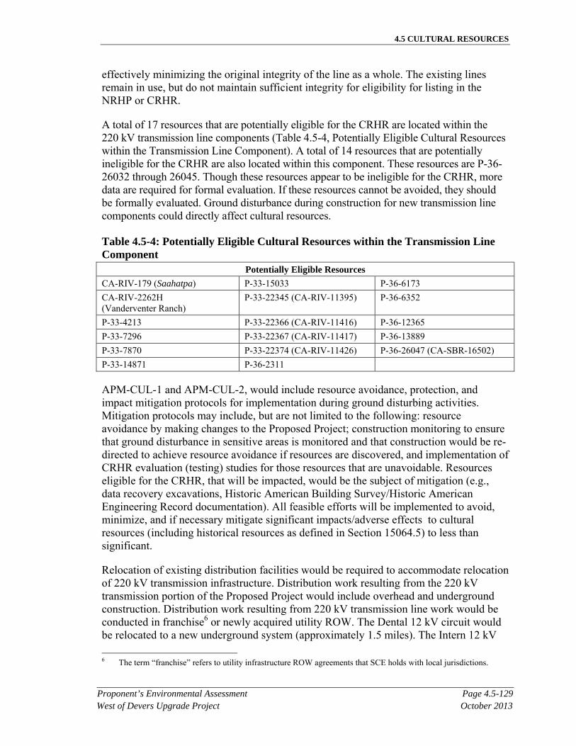
4.5 CULTURAL RESOURCES
Proponent’s Environmental Assessment Page 4.5-129West of Devers Upgrade Project October 2013
effectively minimizing the original integrity of the line as a whole. The existing lines remain in use, but do not maintain sufficient integrity for eligibility for listing in the NRHP or CRHR.
A total of 17 resources that are potentially eligible for the CRHR are located within the 220 kV transmission line components (Table 4.5-4, Potentially Eligible Cultural Resources within the Transmission Line Component). A total of 14 resources that are potentially ineligible for the CRHR are also located within this component. These resources are P-36-26032 through 26045. Though these resources appear to be ineligible for the CRHR, more data are required for formal evaluation. If these resources cannot be avoided, they should be formally evaluated. Ground disturbance during construction for new transmission line components could directly affect cultural resources.
Table 4.5-4: Potentially Eligible Cultural Resources within the Transmission Line Component
Potentially Eligible Resources
CA-RIV-179 (Saahatpa) P-33-15033 P-36-6173
CA-RIV-2262H (Vanderventer Ranch)
P-33-22345 (CA-RIV-11395) P-36-6352
P-33-4213 P-33-22366 (CA-RIV-11416) P-36-12365
P-33-7296 P-33-22367 (CA-RIV-11417) P-36-13889
P-33-7870 P-33-22374 (CA-RIV-11426) P-36-26047 (CA-SBR-16502)
P-33-14871 P-36-2311
APM-CUL-1 and APM-CUL-2, would include resource avoidance, protection, and impact mitigation protocols for implementation during ground disturbing activities. Mitigation protocols may include, but are not limited to the following: resource avoidance by making changes to the Proposed Project; construction monitoring to ensure that ground disturbance in sensitive areas is monitored and that construction would be re-directed to achieve resource avoidance if resources are discovered, and implementation of CRHR evaluation (testing) studies for those resources that are unavoidable. Resources eligible for the CRHR, that will be impacted, would be the subject of mitigation (e.g., data recovery excavations, Historic American Building Survey/Historic American Engineering Record documentation). All feasible efforts will be implemented to avoid, minimize, and if necessary mitigate significant impacts/adverse effects to cultural resources (including historical resources as defined in Section 15064.5) to less than significant.
Relocation of existing distribution facilities would be required to accommodate relocation of 220 kV transmission infrastructure. Distribution work resulting from the 220 kV transmission portion of the Proposed Project would include overhead and underground construction. Distribution work resulting from 220 kV transmission line work would be conducted in franchise6 or newly acquired utility ROW. The Dental 12 kV circuit would be relocated to a new underground system (approximately 1.5 miles). The Intern 12 kV
6 The term “franchise” refers to utility infrastructure ROW agreements that SCE holds with local jurisdictions.
4.5 CULTURAL RESOURCES
Page 4.5-130 Proponent’s Environmental AssessmentOctober 2013 West of Devers Upgrade Project
circuit would be relocated into the same new underground system as the Dental 12 kV circuit, and a portion would be underbuilt on an existing 66 kV subtransmission line. These distribution lines (P-36-26223) include typical and standard pole design and technology, and have been continuously upgraded and modified, effectively minimizing the original integrity of the line as a whole. The existing lines remain in use, but do not maintain sufficient integrity for eligibility for listing in the CRHR.
Additionally, the relocations of both the San Bernardino-Redlands-Timoteo 66 kV and the San Bernardino-Redlands-Tennessee 66 kV subtransmission lines would require the additional relocation of existing distribution circuits and associated equipment from existing poles to new subtransmission poles exclusively in Segment 1. The subtransmission lines (P-36-26224) include typical and standard pole design and technology, and have been continuously upgraded and modified, effectively minimizing the original integrity of the line as a whole. The existing lines remain in use, but do not maintain sufficient integrity for eligibility for listing in the CRHR.
A total of fifteen resources that are potentially eligible for the CRHR are located within the 12 kV distribution line component. These are sites P-36-13889, P-36-26225 through -26228, P-36-2311, P-36-6173, P-36-10565, P-36-12365, P-36-13891, and P-36-19927. Several resources that are potentially eligible for the CRHR are located within multiple project components. Ground disturbance for the distribution line could directly affect historical resources. Table 4.5-3, Impact Areas and Tower Impacts for Cultural Resources in the APE/Project Study Area, identifies potential impacts to these resources based on preliminary design for the Proposed Project; however, actual impacts to these resources as a result of ground-disturbing activities during construction may change depending on configuration of final design.
APM-CUL-1 and APM-CUL-2, would include resource avoidance, protection, and impact mitigation protocols for implementation during ground-disturbing activities. Mitigation protocols may include, but are not limited to the following: resource avoidance by making changes to the Proposed Project; construction monitoring to ensure that ground disturbance in sensitive areas is monitored and that construction would be redirected to achieve resource avoidance if resources are discovered; and implementation of CRHR evaluation (testing) studies for those resources that are unavoidable. Resources that are eligible for the CRHR and that would be affected would be the subject of mitigation (e.g., data recovery excavations, Historic American Building Survey/Historic American Engineering Record documentation). All feasible efforts will be implemented to avoid, minimize, and if necessary mitigate significant impacts/adverse effects to cultural resources (including historical resources as defined in Section 15064.5) to less than significant.
66 kV Subtransmission Lines. The Proposed Project would require relocation of portions of the existing San Bernardino-Redlands-Timoteo (approximately 2 miles) and the San Bernardino-Redlands-Tennessee 66 kV (approximately 3.5 miles) subtransmission lines located within Segment 1 to new routes within existing ROW or franchise, or newly acquired ROW. The relocated 66 kV subtransmission lines would be constructed within new ROW or existing franchise. The 66 kV subtransmission lines (P-
4.5 CULTURAL RESOURCES
Proponent’s Environmental Assessment Page 4.5-131West of Devers Upgrade Project October 2013
36-26224) include typical and standard pole design and technology, and have been continuously upgraded and modified, effectively minimizing the original integrity of the line as a whole. The existing lines remain in use, but do not maintain sufficient integrity for eligibility for listing in the CRHR.
A total of five resources that are potentially eligible for the CRHR are located within the 66 kV subtransmission line component. These are sites P-36-13889, P-36-1134, P-36-2311, P-36-6173, and P-36-12365. Several resources that are potentially eligible for the CRHR are located within multiple project components. A total of five resources that are potentially ineligible for the CRHR are also located within this component. These resources are P-36-26032, P-36-26034, P-36-26036, P-36-26038, and P-36-26040. Though these resources appear to be ineligible for the CRHR, more data are required for formal evaluation. If these resources cannot be avoided, they should be formally evaluated. Ground disturbance for new subtransmission line components could directly affect cultural resources. Table 4.5-3, Impact Areas and Tower Impacts for Cultural Resources in the APE/Project Study Area, identifies potential impacts to these resources based on preliminary design for the Proposed Project; however, actual impacts to these resources as a result of ground-disturbing activities during construction may change depending on configuration of final design.
APM-CUL-1 and APM-CUL-2, would include resource avoidance, protection, and impact mitigation protocols for implementation during ground-disturbing activities. Mitigation protocols may include, but are not limited to the following: resource avoidance by making changes to the Proposed Project; construction monitoring to ensure that ground disturbance in sensitive areas is monitored and that construction would be redirected to achieve resource avoidance if resources are discovered; and implementation of CRHR evaluation (testing) studies for those resources that are unavoidable. Resources that are eligible for the CRHR and that would be affected would be the subject of mitigation (e.g., data recovery excavations, Historic American Building Survey/Historic American Engineering Record documentation). All feasible efforts will be implemented to avoid, minimize, and if necessary mitigate significant impacts/adverse effects to cultural resources (including historical resources as defined in Section 15064.5) to less than significant.
Telecommunications. The new telecommunications infrastructure would include additions and modifications to the existing telecommunications system in order to maintain telecommunications operations during and after construction of the Proposed Project. The telecom infrastructure would be constructed in new and existing underground conduit and cable trench, and on existing riser, distribution and subtransmission poles. Additionally, removal of the fiber optic portions from the 220 kV existing structures to connections in the field and/or at existing substations would be required. Telecommunications equipment and cables would be installed along the same route as the 220 kV transmission lines, as well as other locations outside of the existing WOD corridor as shown in Figure 3.1-6, Telecommunications Route Description. The telecommunication routes outside of the 220 kV ROW are associated with existing substations, and would be constructed primarily in existing public streets.
4.5 CULTURAL RESOURCES
Page 4.5-132 Proponent’s Environmental AssessmentOctober 2013 West of Devers Upgrade Project
The existing telecommunications line (P-36-23484) has typical and standard design and technology, and has been continuously upgraded and modified as necessary, effectively minimizing the original integrity of the line as a whole. The existing lines remain in use, but do not maintain sufficient integrity for eligibility for listing in the CRHR.
A total of six resources that are potentially eligible for the CRHR are located within the telecommunications component. These resources are CA-RIV-179, P-33-7296, P-33-15992, P-33-16904, P-33-16907, and P-33-16961. Several resources that are potentially eligible for the CRHR are located within multiple project components. A total of 115 resources that are potentially ineligible for the CRHR are also located within this component. These resources are P-33-22386 and P-33-23484 through 23598. Though these resources appear to be ineligible for the CRHR, more data are required for formal evaluation. If these resources cannot be avoided, they should be formally evaluated. Ground disturbance for new telecommunication line components could directly affect cultural resources. Table 4.5-3, Impact Areas and Tower Impacts for Cultural Resources in the APE/Project Study Area, identifies potential impacts to these resources based on preliminary design for the Proposed Project; however, actual impacts to these resources as a result of ground-disturbing activities during construction may change depending on configuration of final design. Above-ground design may include adding additional lines to existing poles. This, along with under-grounding portions of the telecommunication component would not significantly change the existing setting of the historic built environment. Therefore, the integrity of resources affected by this impact would not be diminished.
APM-CUL-1 and APM-CUL-2, would include resource avoidance, protection, and impact mitigation protocols for implementation during ground-disturbing activities. Mitigation protocols may include, but are not limited to the following: resource avoidance by making changes to the Proposed Project; construction monitoring to ensure that ground disturbance in sensitive areas is monitored and that construction would be redirected to achieve resource avoidance if resources are discovered; and implementation of CRHR evaluation (testing) studies for those resources that are unavoidable. Resources that are eligible for the CRHR and that would be affected would be the subject of mitigation (e.g., data recovery excavations, Historic American Building Survey/Historic American Engineering Record documentation). All feasible efforts will be implemented to avoid, minimize, and if necessary mitigate significant impacts/adverse effects to cultural resources (including historical resources as defined in Section 15064.5) to less than significant.
Staging Yards. SCE anticipates using one or more of the possible temporary staging yards listed in Table 3.2-A, Potential Staging Yard Locations, and seen in Figure 3.2-1, Potential Staging Yard Locations, used as a reporting location for workers, vehicle and equipment parking, and material storage. Typically, each yard would be 3 to 20 acres in size, depending on land availability and intended use. Preparation of the staging yard would include temporary perimeter fencing and, depending on existing ground conditions at the site, include the application of gravel or crushed rock. Any land that may be disturbed at the staging yard would be restored to pre-construction conditions or to conditions agreed upon between SCE and the landowner following the completion of
4.5 CULTURAL RESOURCES
Proponent’s Environmental Assessment Page 4.5-133West of Devers Upgrade Project October 2013
construction for the Proposed Project. Eight cultural resources were observed in six of the staging yard locations. All are ineligible for the CRHR, therefore, impacts would be less than significant. The resources are described below in Table 4.5-5, Cultural Resources Observed in Staging Yard Locations.
Table 4.5-5: Cultural Resources Observed in Staging Yard Locations Staging
Yard Resources Description Eligibility
Beaumont P-33-9498 Southern Pacific Railroad Portion in staging yard ineligible
Grand Terrace
P-36-7168 Historic water conveyance Portion in staging yard ineligible
Hathaway 2 P-33-22387 and -22388
Historic artifact scatters Both ineligible
Mountain View
P-36-26031 (CA-SBR-16501H)
Historic water conveyance Ineligible
Poultry P-33-13429 and 13430 Survey determined recorded resources are non-cultural
Both ineligible
San Timoteo P-33-15845 Historic Residence Ineligible
Operation Impacts
Normal operation of the lines would be controlled remotely through SCE control systems, and manually in the field as required. SCE inspects the subtransmission overhead and underground facilities in a manner consistent with CPUC GO 165 a minimum of once per year via ground and/or aerial observation. Maintenance would occur as needed and could include activities such as repairing conductors, washing or replacing insulators, repairing or replacing other hardware components, replacing poles, tree trimming, brush and weed control, and access road maintenance. Most regular O&M activities of overhead facilities are performed from existing access roads with no surface disturbance. Repairs to facilities, such as repairing or replacing poles and structures, could occur in undisturbed, but previously surveyed areas. Therefore, operation impacts to cultural resources (including historical resources as defined in Section 15064.5) would be less than significant.
Would the project cause a substantial adverse change in the significance of an archaeological resource pursuant to Section 15064.5?
The following discussion addresses all Proposed Project components, including substation modifications, 220 kV transmission lines, 66 kV subtransmission lines, 12 kV distribution lines, telecommunication facilities, and the establishment of staging yards.
Construction Impacts
The APE/Project Study Area contains 26 resources that are considered potentially eligible for listing in the CRHR and eight resources that have been previously evaluated and recommended eligible for listing in the CRHR (Table 4.5-2, Description, Preliminary NRHP/CRHR Eligibility, Recommendations, and Impact Summary for Cultural
4.5 CULTURAL RESOURCES
Page 4.5-134 Proponent’s Environmental AssessmentOctober 2013 West of Devers Upgrade Project
Resources in the APE/Project Study Area). Preliminary project design plans indicate that 11 of these resources would likely receive some type of impact. Of those 11 resources subject to impact, structures would affect only three, while the balance would be affected by such actions as road improvement or other light grading. Ground disturbance during construction for new transmission lines, subtransmission lines, distribution lines, staging yards, and telecommunication line components could directly affect cultural resources. Table 4.5-3, Impact Areas and Tower Impacts for Cultural Resources in the APE/Project Study Area, identifies potential impacts to these resources based on preliminary design for the Proposed Project; however, actual impacts to these resources as a result of ground-disturbing activities during construction may change depending on configuration of final design.
APM-CUL-1 and APM-CUL-2, would include resource avoidance, protection, and impact mitigation protocols for implementation during ground-disturbing activities. Mitigation protocols may include, but are not limited to the following: resource avoidance by making changes to the Proposed Project during subsequent design phases; construction monitoring to ensure that ground disturbance in sensitive areas is monitored and that construction would be redirected to achieve resource avoidance if resources are discovered; and implementation of CRHR evaluation (testing) studies for those resources that are unavoidable. Resources that are eligible for the CRHR that would be affected would be the subject of mitigation (e.g., data recovery excavations, Historic American Building Survey/Historic American Engineering Record documentation). All feasible efforts will be implemented to avoid, minimize, and if necessary mitigate significant impacts/adverse cultural resources (including historical resources as defined in Section 15064.5) to less than significant.
Operation Impacts
Normal operation of the lines would be controlled remotely through SCE control systems, and manually in the field as required. SCE inspects the subtransmission overhead and underground facilities in a manner consistent with CPUC GO165 a minimum of once per year via ground and/or aerial observation. Maintenance would occur as needed and could include activities such as repairing conductors, washing or replacing insulators, repairing or replacing other hardware components, replacing poles, tree trimming, brush and weed control, and access road maintenance. Most regular O&M activities of overhead facilities are performed from existing access roads with no surface disturbance. Repairs to facilities, such as repairing or replacing poles and structures, could occur in undisturbed, but previously surveyed areas. Therefore, operation impacts to the significance of an archaeological resource would be less than significant.
Would the project disturb any human remains, including those interred outside of formal cemeteries?
The following discussion addresses all Proposed Project components, including substation modifications, 220 kV transmission lines, 66 kV subtransmission lines, 12 kV distribution lines, telecommunication facilities, and the establishment of staging yards.
4.5 CULTURAL RESOURCES
Proponent’s Environmental Assessment Page 4.5-135West of Devers Upgrade Project October 2013
Construction Impacts
There are known cemeteries present at the St. Boniface Indian School and the historic Native American village of Saahatpa. The Proposed Project spans a historic cemetery (P-33-16898) on the eastern end of Segment 5. Existing access roads at both of these locations would be used as part of the 220 kV transmission line component. Utilization of access roads would not affect P-33-4213 (CA-RIV-4213H) Saint Boniface School, or CA-RIV-179 (Sahat’pa).
Encountering human remains at other locations is considered unlikely because the results of the record search and pedestrian field surveys do not indicate the presence of sites likely to contain human remains. If human remains were encountered during construction, all work would stop and the county coroner and a qualified archaeologist would be notified, pursuant to Public Resources Code Sections 5097.98 and 5097 and CEQA Guidelines 15064.5 (e)(1), ensuring that impacts would be less than significant (APM-CUL-2).
Operation Impacts
Normal operation of the lines would be controlled remotely through SCE control systems, and manually in the field as required. SCE inspects the subtransmission overhead and underground facilities in a manner consistent with CPUC GO 165 a minimum of once per year via ground and/or aerial observation. Maintenance would occur as needed and could include activities such as repairing conductors, washing or replacing insulators, repairing or replacing other hardware components, replacing poles, tree trimming, brush and weed control, and access road maintenance. Most regular O&M activities of overhead facilities are performed from existing access roads with no surface disturbance. Repairs to facilities, such as repairing or replacing poles and structures, could occur in undisturbed, but previously surveyed areas. Therefore, no operation impacts to human remains are anticipated.
4.5.4.2 NEPA Impact Assessment
Would the project alter, directly or indirectly, any of the characteristics of a historic property that qualify the property for inclusion in the NRHP in a manner that would diminish the integrity of the property’s location, design, setting, materials, workmanship, feeling, or association?
The following discussion addresses all Proposed Project components, including substation modifications, 220 kV transmission lines, 66 kV subtransmission lines, 12 kV distribution lines, telecommunication facilities, and the establishment of staging yards.
Construction Impacts
Ground-disturbing activities during construction of the Proposed Project have the potential to affect cultural resources. The APE/Project Study Area contains 29 resources that are considered potentially eligible for listing within the NRHP and five resources which have been previously evaluated and recommended eligible for listing within the
4.5 CULTURAL RESOURCES
Page 4.5-136 Proponent’s Environmental AssessmentOctober 2013 West of Devers Upgrade Project
NRHP (Table 4.5-2, Description, Preliminary NRHP/CRHR Eligibility, Recommendations, and Impact Summary for Cultural Resources in the APE/Project Study Area). Preliminary project design plans indicate that 11 of these resources would likely receive some type of impact. Of those 11 resources subject to impact, structures would affect only three, while the balance would be affected by such actions as road improvement or other light grading.
A provisional assessment of impacts can be based on the currently available level of engineering design and preliminary evaluations of resource eligibility. Upon final design, any unevaluated resources subject to impacts would be evaluated, and impacts to all historic properties would be further assessed. Table 4.5-3, Impact Areas and Tower Impacts for Cultural Resources in the APE/Project Study Area, identifies potential impacts to these resources based on preliminary design for the Proposed Project; however, actual impacts to these resources as a result of ground-disturbing activities during construction may change depending on configuration of final design.
APM-CUL-1 and APM-CUL-2, would include resource avoidance, protection, and impact mitigation protocols for implementation during ground-disturbing activities. Mitigation protocols may include, but are not limited to the following: resource avoidance by making changes to the Proposed Project; construction monitoring to ensure that ground disturbance in sensitive areas is monitored and that construction would be redirected to achieve resource avoidance if resources are discovered; and implementation of NRHP eligibility (testing) studies for those historic properties that are unavoidable. Historic properties eligible for the NRHP that would be affected would be the subject of mitigation (e.g., data recovery excavations, Historic American Building Survey/Historic American Engineering Record documentation). Implementation of the mitigation protocols would be expected to resolve adverse effects in most cases.
Cultural resources within the APE/Project Study Area that are or may be eligible for the CRHR are identified, below, by project component. Table 4.5-3, Impact Areas and Tower Impacts for Cultural Resources in the APE/Project Study Area, shows all impacts to resources within the APE/Project Study Area by type of impact. Impacts are described as either permanent or temporary. A permanent impact is substantial and results from the construction and/or operation of long-term project improvements. A temporary impact is minor and results from short term activities, such as work area access or wire-pulling, although ground disturbance within the limits of a cultural resource could have the potential for causing permanent damage.
An undertaking has an effect on a historic property when the undertaking may alter characteristics of the property that may qualify the property for inclusion in the NRHP. An undertaking is considered to have an adverse effect when the effect on a historic property may diminish the integrity of the property’s location, design, setting, materials, workmanship, feeling, or association. Potential for adverse effects cannot be assessed in full detail until final design. Table 4.5-3, Impact Areas and Tower Impacts for Cultural Resources in the APE/Project Study Area, identifies potential impacts to these resources as a result of ground-disturbing activities during construction based on preliminary
4.5 CULTURAL RESOURCES
Proponent’s Environmental Assessment Page 4.5-137West of Devers Upgrade Project October 2013
design for the Proposed Project; however, actual impacts to these resources may change depending on configuration of final design.
APM-CUL-1 and APM-CUL-2, would include resource avoidance, protection, and impact mitigation protocols for implementation during ground-disturbing activities. Implementation of the mitigation protocols would, in most cases, resolve adverse effects.
Regarding indirect effects, the existing setting is characterized by the presence of transmission line towers. The Proposed Project would not have a qualitative change to the existing setting as the construction of transmission structures is proposed for replacement of the existing transmission towers. The proposed telecommunication line would be hung on existing power poles or installed underground, which does not represent a substantial change to the existing setting. Potentially historic properties would not be isolated from their settings, and the characters of their settings would not be altered as a result of the Proposed Project. There would be no introduction of visual, audible, or atmospheric elements that are out of character with these properties or that would alter their settings. Therefore, there would be no changes to these properties’ qualification for the NRHP.
Operation Impacts
As stated above, normal operation of the lines would be controlled remotely through SCE control systems, and manually in the field as required (pursuant to CPUC GO 165). Maintenance would occur as needed and could include activities such as repairing conductors, washing or replacing insulators, repairing or replacing other hardware components, replacing poles, tree trimming, brush and weed control, and access road maintenance. Most regular O&M activities of overhead facilities are performed from existing access roads with no surface disturbance. Repairs to facilities, such as repairing or replacing poles and structures, could occur in undisturbed areas. Therefore, no impacts to resources during operation of the Proposed Project are anticipated.
4.5.5 Paleontological Resources Environmental Setting
In order to address resource significance and effect/impact, cultural resources are framed within cultural, historic, and archaeological contexts. Paleontological resources are discussed and presented within geologic and fossil resource significance contexts below.
4.5.5.1 Regional Geologic Setting
The APE/Project Study Area for the Proposed Project is located in the Peninsular Ranges Province of southern California and in the westernmost portions of the Colorado Desert Province. The Peninsular Ranges are oriented northwest to southeast and include a complex of blocks separated by similarly trending faults. Some igneous rocks of Nevadan age plutonism (~117 million years ago (mya)–Mesozoic) are exposed in the San Jacinto Mountains, including granodiorite and diorite, clasts of which can be found in the San Timoteo Formation and other Quaternary units (Norris and Webb 1976).
4.5 CULTURAL RESOURCES
Page 4.5-138 Proponent’s Environmental AssessmentOctober 2013 West of Devers Upgrade Project
Devers Substation at the eastern end of the APE/Project Study Area is located within the Colorado Desert Province, an area characterized by low elevations, internal drainage, and low precipitation. The valley between the San Bernardino Mountains on the north, and the San Jacinto Mountains of the Peninsular Ranges geomorphic province on the south, is known as San Gorgonio Pass. The San Gorgonio Pass is an east to west-trending lowland, forming a natural break between the San Bernardino Mountains and the San Jacinto Mountains. The surface of the lowland is derived by alluvial fan deposits, mainly from the San Bernardino Mountains. The northern foothills are underlain by upper Cenozoic non-marine and marine sedimentary deposits (Morton 1999).
The pass drains to the east into the Coachella Valley and to the west into the Los Angeles Basin. One of the major drainages to the west of the pass is San Timoteo Canyon, which trends generally in an east-west direction. The canyon bisects terraced badlands that are composed of Quaternary and Tertiary non-marine sediments that date from the Pliocene to the Pleistocene. The pass and canyon areas are composed of late Holocene wash deposits that cut into younger alluvial deposits that date from the late Pleistocene to Holocene. There are exposures of older alluvial and channel deposits from the middle to late Pleistocene that derive from the surrounding mountains (Morton 1999).
Faults dominate the structure of the Peninsular Ranges. In the APE/Project Study Area, the activity of the San Jacinto Fault Zone is the dominating fault that gave rise to the features visible today, and is the driving force behind the stratigraphy of San Timoteo Canyon. The San Andreas Fault contributes greatly to the topography of the APE/Project Study Area as a whole. Compressional forces resulting from motion within and along the San Andreas-San Jacinto Fault Complex have uplifted and deformed sediments along the western and central portions of the APE/Project Study Area (Albright 1999a: 1265–1293), and erosion and uplift characterize the eastern portion of the APE/Project Study Area.
The western and central portions of the APE/Project Study Area are located in the San Timoteo Badlands, characterized by gently rolling hills, moderate washes, and uplifted sediments plunging to the northwest. The Badlands are bounded immediately to the southwest by the San Jacinto Fault Zone. The Badlands sequence of the San Timoteo Formation was deposited in a basin located between what are now the San Andreas and San Jacinto Fault zones over 6 million years; movement along these fault zones in the last 1.5 million years has uplifted these sediments (Albright 1999a: 1265–1293).
The eastern portion of the APE/Project Study Area, between the intersection of the Proposed Project alignment and Interstate 10, is largely characterized by younger and coarser rock units than found in the western and central portions of the Proposed Project. Some portions of the San Timoteo Formation are located in this area. However, Quaternary alluvial and fan deposits dominate the landscape. The Miocene Coachella Fanglomerate is found in limited amounts to the eastern side of this area. The Coachella Fanglomerate was first named by Vaughan (1922:319–411) as a thick alluvial-type depositional unit with a basal breccia sourced from the San Bernardino Mountains to the north. It contains volcanic units and basalt flows in some places (Allen 1954).
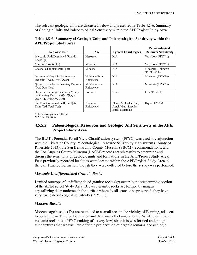
4.5 CULTURAL RESOURCES
Proponent’s Environmental Assessment Page 4.5-139West of Devers Upgrade Project October 2013
The relevant geologic units are discussed below and presented in Table 4.5-6, Summary of Geologic Units and Paleontological Sensitivity within the APE/Project Study Area.
Table 4.5-6: Summary of Geologic Units and Paleontological Sensitivity within the APE/Project Study Area
Geologic Unit Age Typical Fossil Types Paleontological
Resource Sensitivity Mesozoic Undifferentiated Granitic Rocks (gr)
Mesozoic N/A Very Low (PFYC 1)
Miocene Basalts (Tb) Miocene N/A Very Low (PFYC 1)
Coachella Fanglomerate (Tcf) Miocene N/A Moderate/ Unknown (PFYC3a/3b)
Quaternary Very Old Sedimentary Deposits (Qvoa, Qvof, Qvor)
Middle to Early Pleistocene
N/A Moderate (PFYC3a)
Quaternary Older Sedimentary Deposits (Qof, Qoa, Qog)
Middle to Late Pleistocene
N/A Moderate (PFYC3a)
Quaternary Younger and Very Young Sedimentary Deposits (Qa, Qf, Qls, Qw, Qyf, Qyls, Qyw, Qg)
Holocene None Low (PFYC 1)
San Timoteo Formation (Qste, Qstr, Tstm, Tstl, Tstrl, Tstf)
Pliocene- Pleistocene
Plants, Mollusks, Fish, Amphibians, Reptiles, Birds, Mammals
High (PFYC 5)
APE = area of potential effects N/A = not applicable
4.5.5.2 Paleontological Resources and Geologic Unit Sensitivity in the APE/Project Study Area
The BLM’s Potential Fossil Yield Classification system (PFYC) was used in conjunction with the Riverside County Paleontological Resource Sensitivity Map system (County of Riverside 2013), the San Bernardino County Museum (SBCM) recommendations, and the Los Angeles County Museum (LACM) records search results to determine and discuss the sensitivity of geologic units and formations in the APE/Project Study Area. Four previously recorded localities were located within the APE/Project Study Area in the San Timoteo Formation, though they were collected before the survey was performed.
Mesozoic Undifferentiated Granitic Rocks
Limited outcrops of undifferentiated granitic rocks (gr) occur in the westernmost portion of the APE/Project Study Area. Because granitic rocks are formed by magma crystallizing deep underneath the surface where fossils cannot be preserved, they have very low paleontological sensitivity (PFYC 1).
Miocene Basalts
Miocene age basalts (Tb) are restricted to a small area in the vicinity of Banning, adjacent to both the San Timoteo Formation and the Coachella Fanglomerate. While basalt, as a volcanic rock, has a PFYC ranking of 1 (very low) since it is was formed under high temperatures that are unsuitable for the preservation of organic remains, the geologic
4.5 CULTURAL RESOURCES
Page 4.5-140 Proponent’s Environmental AssessmentOctober 2013 West of Devers Upgrade Project
units that the basalts are found within have higher sensitivity (Coachella Fanglomerate PFYC 3a/3b-moderate/unknown, San Timoteo Formation PYFC 5-very high).
Coachella Fanglomerate (Miocene)
The Coachella Fanglomerate (Tcf) is a highly variable unit laterally in terms of composition and thickness, reflecting the sourcing of clasts and varied depositional environments from debris flow to riverine/stream. Largely made up of clasts from the local San Bernardino Mountains, it may contain granitic or schist clasts, as well as some basalt flow. This unit is generally well-indurated, poorly sorted, variable in color, and has a medium-grained sand matrix (Allen 1954). No fossils have been reported in this formation; however, during surveying for this Proposed Project, numerous paleosols and root casts were observed within this formation in finer beds. These conditions illustrate the possibility that fossils may be found in this formation. This formation has been given a Moderate/Unknown PFYC ranking (PFYC Class 3a/3b).
Quaternary Very Old Sedimentary Deposits
Quaternary very old deposits include axial deposits (Qvoa), alluvial fan deposits (Qvof), and regolith (Qvor). These units are all terrestrial alluvial deposits of middle to early Pleistocene age. They are described as consisting of sandy alluvium or gravel that is generally reddish brown, often well-indurated, and often well-dissected (Morton and Miller 2006). They may be present as deeply weathered rock and soil (Ibid.). No records of fossils from these units were found in the literature from within the APE/Project Study Area. However, these units are similar to those found throughout southern California of the same age, which have produced numerous scientifically important Pleistocene-aged fossils (Jefferson 1991). In combination, these very old deposits are considered to have moderate paleontological sensitivity (PFYC Class 3a).
Quaternary Older Sedimentary Deposits
Quaternary older sedimentary deposits include Quaternary older alluvial fan (Qof), Quaternary older axial channel (Qoa: Morton), Quaternary older fan (Qof: Dibblee), Quaternary older alluvium (Qoa: Dibblee), and Quaternary older gravel deposits (Qog). These deposits have a similar depositional environment, composition and appearance to that of the very old deposits above (red-brown to gray silty sands, gravels, and alluvial deposits), but are of the middle to late Pleistocene in age (Morton and Miller 2006; Dibblee 2003a, 2003b, 2004a, 2004b, 2004c). No records of fossils from these units were found in the literature from within the APE/Project Study Area. However, these units are similar to those found throughout southern California of the same age, which have produced numerous scientifically important Pleistocene-aged fossils (Jefferson 1991; Morton and Miller 2006). In combination, these units are considered to have moderate paleontological sensitivity (PFYC Class 3a).
Quaternary Younger and Very Young Sedimentary Deposits
Quaternary younger and very young sedimentary deposits include Quaternary very young axial channel deposits (Qa), Quaternary very young alluvial fan deposits (Qf), Quaternary
4.5 CULTURAL RESOURCES
Proponent’s Environmental Assessment Page 4.5-141West of Devers Upgrade Project October 2013
very young landslide deposits (Qls), Quaternary very young wash deposits (Qw), Quaternary young alluvial fan deposits (Qyf), Quaternary young landslide deposit (Qyls), Quaternary young wash deposits (Qyw), Quaternary alluvium (Dibblee: Qa), Quaternary fan deposits (Dibblee, Qf), and Quaternary gravel deposits (Qg). These units are all alluvial and landslide deposits of Holocene age (Morton and Miller 2006). Because they are too young to contain in situ fossils, they are considered to have low paleontological sensitivity (PFYC Class 2), although it should be noted that they may shallowly cover units of higher PFYC ranking. Furthermore, in the El Casco Substation area, Paleo Solutions and LSA data and direct field observations indicate that much of the area mapped as Qyls (LSA 2012; Paleo Solutions 2012) is in fact the very highly sensitive San Timoteo Formation. Areas believed to be erroneously mapped by Dibblee of Qyls have been designated PFYC3b, unknown sensitivity.
San Timoteo Formation (Pliocene-Pleistocene)
The Plio-Pleistocene San Timoteo Formation is a very high sensitivity terrestrial sedimentary sequence. It was deposited between ~6.2 mya and 0.78 mya. The San Timoteo Formation is a largely badlands type exposure of sedimentary rock that extends about 30 kilometers southeast from the San Bernardino Basin. The basal member is a ripple-bedded, laminated sandstone, located in the Jackrabbit Trail and Eden Springs area (Albright 1999:1–121). Above this member lies a sequence of poorly indurated sandstone, siltstone, and sandy mudstone with conglomeratic lenses, which is discussed below. Overlying this is a sequence of generally coarser, reddish sediment that is characterized by thick, sheet-like pebble sandstone and cobble conglomerate that may exhibit some scouring into underlying units (Ibid.). This unit is thought to represent intermittent braided stream sheetwash (Matti and Morton 1975:344) with clasts sourced from the adjacent mountains. Some lenses of massive, fine-grained calcareous ‘marls’ representing shallow marshes have been reported (Albright 1999:1–121). The San Timoteo Formation is generally laterally very inconsistent due to both uplift and the nature of lacustrine and riverine depositional environments (LSA 2012; Paleo Solutions 2012).
The San Timoteo Formation is a lithologically diverse formation composed of sandstone, conglomeratic sandstone, conglomerate, and occasional mudstone. It is an entirely terrestrial alluvial deposit with sediment sources appearing to be entirely derived from a Transverse Range source similar in composition to rocks presently exposed in the eastern San Gabriel Mountains, central San Bernardino Mountains, and the San Bernardino-Yucaipa area (Matti and Morton 1993:107–159). Most sandstone is arkosic (composed of at least 25 percent of the mineral feldspar) and much of the sand composition is lithic (small rock fragments). This formation was first named by Frick (1921:277–424) for an upper Pliocene, vertebrate-bearing, non-marine strata in San Timoteo Canyon. According to Albright (1999a:1265–1293), the San Timoteo Formation may reach a maximum thickness of 2,000 feet, but this is only an estimate due to extensive vegetation cover, discontinuous beds, and movement along faults. The upper portion of the San Timoteo beds contains vertebrate fauna of earliest Pleistocene, while the lower beds are from the Pliocene (Morton and Miller 2006). The San Timoteo Formation itself is not Miocene but
4.5 CULTURAL RESOURCES
Page 4.5-142 Proponent’s Environmental AssessmentOctober 2013 West of Devers Upgrade Project
in some areas it abuts and/or surrounds the very low sensitivity basalts (non-conformably).
Morton and Miller (2006) have divided the formation into five informal members, some of which contain additional subdivisions based primarily on their composition and location. The five informal members include the Upper Member (Qstu), the Middle Member (Tstm), the Lower Sandstone Member (Tstl), the Ripple Laminated Member (Tstrl), and the Fine-Grained Member (Tstf). The Ripple Laminated Member (Tstrl) and the Fine-Grained Member (Tstf) were formerly listed as part of the underlying Mount Eden Formation (Tme). The Upper Member was deposited during the early to middle Pleistocene (1.8 million years–700,000 years), and all the other members were deposited 4.3–1.8 mya during the Pliocene (Morton and Miller 2006). The fossils discovered during the surveys in 2013 were located within this Upper Member.
Within the APE/Project Study Area, sediments from the Upper Member (Qstu), the Reche Canyon Member of the Upper Member (Qstr), the Middle Member (Tstm), the Lower Sandstone Member (Tstl), and the Ripple Laminated Member (Tstrl) are exposed. Table 4.5-1, Local Land Use Documents Applicable to Cultural Resources for the Proposed Project, summarizes the paleontological sensitivity of each geologic unit within the APE/Project Study Area. These sediments are described in more detail below.
4.5.5.3 The San Timoteo Formation within the APE/Project Study Area and Fossil Species Observed
The APE/Project Study Area runs westerly through the upper portion of the San Timoteo Formation. This formation yields critical information that describes the climatic, botanic, and zoological transitions through three North American Land Mammal Ages—the Hemphillian, Blancan, and early Irvingtonian. The 5.0 million year span of deposition (6.2–0.5 Ma) contains exceptional data on the radiation of mammals across the Bering land bridge and from South America to the North American continent. Sediments in the San Timoteo Formation contain evidence that dates the uplift of the Transverse Ranges, the right lateral translation on the San Andreas Fault of the San Bernardino Mountains past the San Gabriel Mountains, and the inception of the San Jacinto Fault. No other terrestrial sequence in North America records the same, essentially continuous, deposition over this period of time (Albright 1999a:1265–1293).
The San Timoteo Formation has produced a very significant assemblage of terrestrial vertebrates and plants spanning the last 5.7 million years. The fossils in the formation have been the subject of investigations for 90 years (Frick 1921:277–424; Matti and Morton 1975:344; Reynolds and Reeder 1991:44–48; LSA 2012). The sediments have produced an excellent record of plants that help decipher past elevations and rainfall patterns (Axelrod 1966:79, 1979:74). The most recent comprehensive studies of the formation (Albright 1999a:1265–1293, 1999:1–121) have recorded 42 taxa of animals such as camel, deer, horse, sloth, elephant, tapir, sloth, dog, bear, rabbit, and rodents. Thirty-six taxa of plants have been recorded (Axelrod 1966:79, 1979:74).
4.5 CULTURAL RESOURCES
Proponent’s Environmental Assessment Page 4.5-143West of Devers Upgrade Project October 2013
Recent fossil recovery by LSA and Paleo Solutions supported by SCE at El Casco Substation in San Timoteo Canyon recovered 67 taxa of plants, mollusks, fish, amphibians, reptiles, birds, insectivores, rodents, deer, camels, horses, sloths and two different saber cats (LSA 2012). This exceptional assemblage from a single sedimentary interval (Upper Member; Qstu) (Morton and Miller 2006) has only 13 taxa in common with the taxa reported from all five members of the entire San Timoteo Formation (Albright 1999:1–121).
SCE’s El Casco Substation study in 2012 recognized 10 species of plants, primarily riparian and aquatic (LSA 2012). This habitat is reinforced by stickleback fish, whose presence hints at ancient drainage systems. The riparian community supported nine types of previously unreported slugs and snails. Amphibians had never before been reported from the San Timoteo Formation, but the LSA work for SCE recovered remains of three salamanders and a frog (Ibid.). The reptiles represent a broader habitat, and include the first records of two species of giant tortoise, a pond turtle, three lizards, and poisonous and non-poisonous snakes. Birds also had not previously been reported from the formation, but monitoring of El Casco Substation construction recovered duck, rail, and scrub jay from the aquatic and riparian area (Ibid.).
New discoveries of fossil mammals are a robust addition to the fauna previously described from the San Timoteo Formation (Albright 1999:1–121). First records of insectivores at El Casco include species of shrew and the broad-footed mole. The round-tailed ground squirrel is a first record. Pocket mice, kangaroo rats, their ancestors, and gophers were recovered. Deer mice and wood rats were recovered, and two species of the latter are new records for the formation. Large and small microtine rodents are present, and the discovery of one species records the first entrance of meadow mice (voles) (Repenning 1987:236–268, 1992:1–98) into the southwestern states (LSA 2012).
Deer and horses were abundant in the El Casco fauna, and one almost complete horse skeleton was recovered. Camels have always been rare in the fauna, but this work recovered a new species of giant camel and a fossil llama. Also unusual, was the recovery of two species of giant ground sloth, including one with a reasonably complete skull and lower jaw (LSA 2012).
Carnivores are rare in any fauna. The El Casco Substation salvage program recovered the first record of a skunk from the San Timoteo Formation. Two different species of saber cat, dirk-tooth cat (Homotherium serum), and ancestral saber tooth cat (Smilodon gracilis) were found at El Casco as partially articulated skeletons (LSA 2012).
The mammalian taxa recovered fill an important biostratigraphic gap not investigated in previous studies (Albright 1999:1–121). A total of 26 of the newly reported mammalian taxa are geographical and temporal range extensions. Only 13 of the mammalian taxa found at El Casco Substation had been previously reported. The entire El Casco Substation fauna and flora is an assemblage that is important to the understanding of the Blancan transition (LSA 2012). This study involved examination of 1,013 invertebrate, 2,816 plant, and 12,080 vertebrate fossils, for a total of 15,909 specimens, which are curated into the Western Science Center as groups of 78 invertebrates, 143 plants, and
4.5 CULTURAL RESOURCES
Page 4.5-144 Proponent’s Environmental AssessmentOctober 2013 West of Devers Upgrade Project
1,701 vertebrates, totaling 1,922 groups of specimens (Ibid.). Geologically and stratigraphically, the sedimentary sequence of the San Timoteo Formation is very important (Matti and Morton 1975:344, 1993:107–159). In addition to providing dates on the uplift and lateral movement of the San Gabriel and San Bernardino Mountain ranges, the silty sands at El Casco suggest that the San Jacinto Fault was becoming active.
During the surveys in 2012, one fossil locality was discovered in the San Timoteo Formation, and during the 2013 surveys, an additional 13 localities were discovered, six of which are significant. Additional important and nonrenewable paleontological resources would certainly continue to be recovered during excavation in the San Timoteo Formation. Due to the diverse and locally abundant fossil vertebrates recovered from this formation in the vicinity of the Proposed Project, it is considered to have very high paleontological sensitivity (PFYC Class 5). The Riverside County General Plan ranks this formation as “High A.” The planning departments of Riverside and San Bernardino counties consider the San Timoteo Formation sensitive and require paleontological resource assessments, monitoring, and salvage.
4.5.6 Paleontological Resources Regulatory Setting
Appendix G (part V) of the CEQA Guidelines provides guidance relative to significant impacts on paleontological resources, which states, “a project will normally result in a significant impact on the environment if it will … disrupt or adversely affect a paleontological resource or site or unique geologic feature, except as part of a scientific study.” Public Resources Code Section 5097.5 specifies that any unauthorized removal of paleontological remains is a misdemeanor.
4.5.6.1 Federal Regulatory Setting
National Environmental Policy Act
The National Environmental Policy Act of 1969, as amended, requires analysis of potential environmental impacts to important historic, cultural, and natural aspects of our national heritage (U.S.C., § 4321 et seq.; 40 C.F.R. § 1502.25). NEPA directs Federal agencies to use all practicable means to “Preserve important historic, cultural, and natural aspects of our national heritage…” (NEPA, Section 101(b) (4)). Regulations for implementing the procedural provisions of NEPA are found in 40 C.F.R. §§ 1500–1508.
If the presence of a significant environmental resource is identified during the scoping process, Federal agencies and their agents must take the resource into consideration when evaluating project effects. Consideration of paleontological resources may be required under NEPA when a project is proposed for development on Federal land, or land under Federal jurisdiction. The level of consideration depends upon the Federal agency involved.
4.5 CULTURAL RESOURCES
Proponent’s Environmental Assessment Page 4.5-145West of Devers Upgrade Project October 2013
Federal Land Policy and Management Act
The Federal Land Policy and Management Act (FLPMA) of 1976 (FLMPA, 43 U.S.C. 1701) includes objectives that include the evaluation, management, protection and location of fossils on BLM-managed lands, defines fossils, and lays out penalties for the destruction of significant fossils.
Paleontological Resources Protection Act
On March 30, 2009, President Barack Obama signed H.R. 146, also known as the Omnibus Public Land Management Act (OPLMA) of 2009, Public Law 111-011 into law. Title VI, Subtitle D, Sections 6301–6312 of this Act is also known as the Paleontological Resources Preservation Act (PRPA), which sets forth protection of paleontological resources located on Federal lands. In general, the PRPA directs the Secretary of the Interior and/or the Secretary of Agriculture to protect paleontological resources by requiring that any work on Federal land that has the potential to contain paleontological resources follow procedures that will protect and preserve those resources for scientific study and future generations. The Omnibus Public Lands Act refines NEPA and FLPMA guidelines and strictures, as well as laying out minimum punishments for removal or destruction of fossils from Federal/public lands.
The BLM uses the PFYC to classify geological formations by their potential to yield important fossils. The lowest sensitivity is PFYC Class 1 and the highest is PFYC Class 5. BLM policies also require any fossils from BLM-administered lands be transferred to an appropriately accredited museum for storage or display after a project ends.
4.5.6.2 State Regulatory Setting
California Environmental Quality Act Guidelines
Appendix G (part V) of the CEQA Guidelines provides guidance relative to significant impacts on paleontological resources, which states, “a project will normally result in a significant impact on the environment if it will …disrupt or adversely affect a paleontological resource or site or unique geologic feature, except as part of a scientific study.” Public Resources Code Section 5097.5 specifies that any unauthorized removal of paleontological remains is a misdemeanor.
4.5.6.3 Local Regulatory Setting
The CPUC has jurisdiction over the siting and design of the Proposed Project because the CPUC regulates and authorizes the construction of IOU facilities. Although such projects are exempt from local land use and zoning regulations and permitting, GO No. 131-D, Section III.C requires “the utility to communicate with, and obtain the input of, local authorities regarding land-use matters and obtain any nondiscretionary local permits.” As part of its environmental review process, SCE considered local and State land use plans and policies, and local land use priorities and concerns. The BLM uses the PFYC to classify geological formations by their potential to yield important fossils, while
4.5 CULTURAL RESOURCES
Page 4.5-146 Proponent’s Environmental AssessmentOctober 2013 West of Devers Upgrade Project
Riverside County uses the Riverside County Paleontological Resource Sensitivity Map system.
4.5.7 Paleontological Resources Significance Criteria
4.5.7.1 CEQA Significance Criteria
Significance criteria for assessing the impacts to paleontological resources come from the CEQA Environmental Checklist. According to the CEQA Checklist, a project causes a potentially significant impact if it would:
Directly or indirectly destroy a unique paleontological resource or site or unique geologic feature
Appendix G (part V) of the CEQA Guidelines provides guidance relative to significant impacts on paleontological resources, which states, “a project will normally result in a significant impact on the environment if it will …disrupt or adversely affect a paleontological resource or site or unique geologic feature, except as part of a scientific study.” Public Resources Code Section 5097.5 specifies that any unauthorized removal of paleontological remains from public lands is a misdemeanor.
4.5.8 Paleontological Resources Impact Analysis
Based on preliminary design plans, 832.23 acres of very high potential (PFYC Class 5; Paleontological Resources Sensitivity Map [PRSM] High A) geologic units and 601 acres of moderate to unknown potential (PFYC 3; PRSM High B) are located within the APE/Project Study Area. Construction of the Proposed Project has the potential to result in direct adverse effects or significant impacts to subsurface fossils as the result of ground disturbance. Table 4.5-7, Impact Areas and Tower Impacts for Geological Units in the APE/Project Study Area, shows all impacts to geological unit in the APE/Project Study Area by type of impact.
One fossil locality (GLA20120214.001) consisting of a gastropod was discovered during the survey on February 14, 2012. Thirteen fossil localities, including six significant and identifiable localities, were discovered during the secondary surveys in March 2013. The significant fossils observed during this survey include MER03112013.001, an extinct horse (Equus sp.) tooth, JTR03112013.01, a gopher (Thomomys sp., cf. T. bottae), JTR03112013.02, an aquatic gastropod (Planorbula sp.?), MER03192013.01, a rodent limb fragment, MER03192013.06, an antelope horn core (Antilocapra cf. sp. A. americana), and JTR03252013.01, a horse tooth (Equus sp. cf. E. bautistensis. These surveys were an incomplete pedestrian survey of access roads, yards, and other Proposed Project-related sites. Portions were not surveyed as of the writing of this document due to restricted or limited access. The four previously recorded fossils provided as museum localities from the records search were collected prior to these areas being surveyed. They were located within the San Timoteo formation and included fossils from a horse (Equus sp.), a large mammal, unidentified chordate (chordate), and a camel (Camelidae). These areas were inspected again during the surveys.

4.5 CULTURAL RESOURCES
Proponent’s Environmental Assessment Page 4.5-147West of Devers Upgrade Project October 2013
Table 4.5-7: Impact Areas and Tower Impacts for Geological Units in the APE/Project Study Area
Impact Areas (acres) Tower
Impacts
Geologic Unit
Permanent Temporary Perm Temp
Gra
din
g L
imit
s (R
OW
)
New
Acc
ess
Roa
ds
Sta
gin
g Y
ard
Tow
er C
onst
ruct
ion
Pad
(R
OW
)
Dis
trib
uti
on
Exi
stin
g A
cces
s R
oads
Gu
ard
Str
uctu
re Z
ones
(R
OW
)
Stru
ctur
e W
ork
Are
a (R
OW
)
Su
btr
ansm
issi
on
Tel
ecom
m
Tow
er D
istu
rban
ce A
rea
(RO
W)
Tow
er T
emp
orar
y D
istu
rban
ce A
rea
(RO
W)
New
Tow
er
Rem
oved
Tow
er
basaltic (Coachella Miocene)Tb 0.0* 0.1 — — — — — 5.8 — — 0.3 0.8 — 2
Box Springs plutonic complex gr — — — — — — — 1.1 — — 0.1 0.4 — —
Coachella fanglomerate (Miocene) Tcf 22.1 4.4 — 1.8 — 14.2 4.9 176.8 — — 8.9 46.4 47 48
Old alluvial-fan deposits, Unit 3 Qof 8.4 1.5 — 0.5 — 9.5 0.0* 63.7 — — 6.1 15.6 20 22
Old axial-channel deposits, Unit 1 Qoa 4.5 1.3 — 0.6 — 2.1 8.1 95.3 — — 1.0 8.9 20 29
Quaternary alluvium Qa 10.8 0.8 10.0 Devers
1.1 — 4.1 10.9 147.2 — 2.2 0.2 21.5 28 39
Quaternary fan deposit Qf 57.8 14.8 11.0 Hathaway 1
4.0 — 53.7 19.5 756.3 — — 19.6 117.9 238 196
Quaternary gravel deposit Qg 5.6 2.1 — 0.4 — 2.8 0.1 68.6 — 0.0* 2.7 14.0 31 15
Quaternary older alluvium Qoa 5.0 1.3 3.8 Beaumont 1
5.0 Beaumont 2
0.5 — 6.3 2.2 98.8 — — 0.8 8.2 21 30
Quaternary older fan deposit Qof 5.7 1.9 — 0.3 — 7.3 0.4 56.7 — — 3.6 13.5 15 17
Quaternary older gravel deposit Qog 0.4 0.0* — 0.1 — 0.7 0.4 5.9 — — 0.1 2 2
San Timoteo Beds Qstr 6.8 2.0 — 0.5 — 4.5 0.8 53.6 — — 7.6 21.5 11 9
San Timoteo Beds Qstu 74.4 7.2 — 2.7 — 33.1 5.3 291.6 — — 53.2 153.0 78 72
San Timoteo Beds Tstl 1.4 0.1 — — — — 1.3 4.9 — — 1.6 3.6 1 1
San Timoteo Beds Tstm 24.2 5.3 3.4 0.6 — 5.9 0.2 88.4 — — 10.3 32.6 29 33
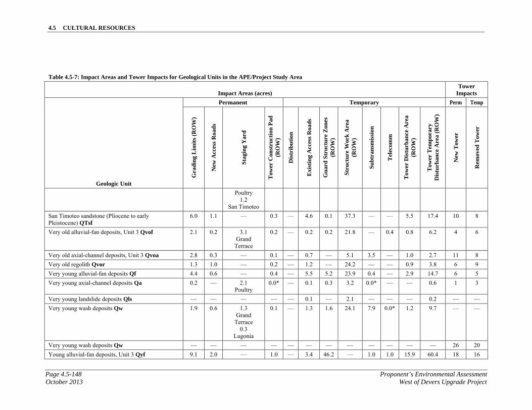
4.5 CULTURAL RESOURCES
Page 4.5-148 Proponent’s Environmental AssessmentOctober 2013 West of Devers Upgrade Project
Table 4.5-7: Impact Areas and Tower Impacts for Geological Units in the APE/Project Study Area
Impact Areas (acres) Tower
Impacts
Geologic Unit
Permanent Temporary Perm Temp
Gra
din
g L
imit
s (R
OW
)
New
Acc
ess
Roa
ds
Sta
gin
g Y
ard
Tow
er C
onst
ruct
ion
Pad
(R
OW
)
Dis
trib
uti
on
Exi
stin
g A
cces
s R
oads
Gu
ard
Str
uctu
re Z
ones
(R
OW
)
Stru
ctur
e W
ork
Are
a (R
OW
)
Su
btr
ansm
issi
on
Tel
ecom
m
Tow
er D
istu
rban
ce A
rea
(RO
W)
Tow
er T
emp
orar
y D
istu
rban
ce A
rea
(RO
W)
New
Tow
er
Rem
oved
Tow
er
Poultry 1.2
San Timoteo
San Timoteo sandstone (Pliocene to early Pleistocene) QTsf
6.0 1.1 — 0.3 — 4.6 0.1 37.3 — — 5.5 17.4 10 8
Very old alluvial-fan deposits, Unit 3 Qvof 2.1 0.2 3.1 Grand
Terrace
0.2 — 0.2 0.2 21.8 — 0.4 0.8 6.2 4 6
Very old axial-channel deposits, Unit 3 Qvoa 2.8 0.3 — 0.1 — 0.7 — 5.1 3.5 — 1.0 2.7 11 8
Very old regolith Qvor 1.3 1.0 — 0.2 — 1.2 — 24.2 — — 0.9 3.8 6 9
Very young alluvial-fan deposits Qf 4.4 0.6 — 0.4 — 5.5 5.2 23.9 0.4 — 2.9 14.7 6 5
Very young axial-channel deposits Qa 0.2 — 2.1 Poultry
0.0* — 0.1 0.3 3.2 0.0* — — 0.6 1 3
Very young landslide deposits Qls — — — — — 0.1 — 2.1 — — — 0.2 — —
Very young wash deposits Qw 1.9 0.6 1.3 Grand
Terrace 0.3
Lugonia
0.1
— 1.3 1.6 24.1 7.9 0.0* 1.2 9.7 — —
Very young wash deposits Qw — — — — — — — — — — — — 26 20
Young alluvial-fan deposits, Unit 3 Qyf 9.1 2.0 — 1.0 — 3.4 46.2 — 1.0 1.0 15.9 60.4 18 16

4.5 CULTURAL RESOURCES
Proponent’s Environmental Assessment Page 4.5-149West of Devers Upgrade Project October 2013
Table 4.5-7: Impact Areas and Tower Impacts for Geological Units in the APE/Project Study Area
Impact Areas (acres) Tower
Impacts
Geologic Unit
Permanent Temporary Perm Temp
Gra
din
g L
imit
s (R
OW
)
New
Acc
ess
Roa
ds
Sta
gin
g Y
ard
Tow
er C
onst
ruct
ion
Pad
(R
OW
)
Dis
trib
uti
on
Exi
stin
g A
cces
s R
oads
Gu
ard
Str
uctu
re Z
ones
(R
OW
)
Stru
ctur
e W
ork
Are
a (R
OW
)
Su
btr
ansm
issi
on
Tel
ecom
m
Tow
er D
istu
rban
ce A
rea
(RO
W)
Tow
er T
emp
orar
y D
istu
rban
ce A
rea
(RO
W)
New
Tow
er
Rem
oved
Tow
er
Young alluvial-fan deposits, Unit 5 Qyf 16.2 4.6 15.8 Poultry
16.6 San Timoteo
0.7 — 19.6 8.4 84.1 — 1.0 15.9 60.4 30 8
Young alluvial-fan deposits, Unit 7 Qyf — — — — — 0.620 — — — — — — — —
Young axial-channel deposits, Unit 3 Qya 11.2 2.4 3.3 Lugonia
3.1 Mountain View 1
1.7 1.5 0.3 0.0* 73.6 49.5 1.3 7.4 27.8 143 94
Young axial-channel deposits, Unit 5 Qya 2.2 0.8 — 0.2 — 0.7 1.1 28.2 — 0.2 1.8 10.4 6 4
Young axial-channel deposits, Unit 6, Qya — — — — — 0.1 1.6 2.7 — — — 0.1 — —
Qya — — — — — 0.2 — — — — — — — —
Young landslide deposits Qyls 13.3 2.1 — 0.5 — 4.6 0.5 56.1 — 0.3 9.6 31.0 17 13
Young wash deposits Qyw 0.9 0.4 — 0.1 — 0.8 1.3 — — 2.5 6.5 — —
Grand Total 298.8 59.0 80.0 18.6 1.5 189.7 71.6 2348.8 61.2 5.6 171.5 670.6 78 72
* A value of 0.0 indicates impacts are present but less than 0.1 acres
4.5 CULTURAL RESOURCES
Page 4.5-150 Proponent’s Environmental AssessmentOctober 2013 West of Devers Upgrade Project
Proposed Project facilities within the study area would likely result in the need for additional paleontological surveys to collect or re-locate any fossil resources on the surface that may be affected by construction that were identified at the surface of the Proposed Project during surveys or that may have eroded onto the surface in the interim. A Paleontological Resources Treatment Plan (PRTP) (APM-PAL-1) for paleontological resources would be prepared based on the results of this report in conjunction with the final selected Proposed Project alignments. The PRTP would, in part, specify procedures and protocols in the event of fossil discoveries, specific monitoring locations, and would be prepared according to BLM guidelines H-8270-1 (BLM 1998) and IM 2009-011 (BLM 2008) as well as applicable State (CEQA) regulations. Contingency plans should be discussed in a PRTP for discovery of fossil resources on private or Tribal lands, as these would need to be addressed in a different manner. Fossils recovered from non-private and non-Tribal lands would be accessioned into an accredited regional repository such as the Western Science Center, the San Bernardino County Museum, or the Los Angeles County Natural History Museum. In accordance with Riverside County regulations, the Western Science Center should have preference as a repository for any fossils found in Riverside County.
4.5.8.1 CEQA Impact Assessment
Would the project directly or indirectly destroy a unique paleontological resource or site or unique geologic feature?
Construction Impacts
Project construction has the potential to result in direct adverse effects or significant impacts to subsurface fossils as the result of ground disturbance. All Proposed Project personnel involved in ground-disturbing activities would be subject to worker environmental awareness training regarding the possible presence of fossils in construction ground disturbance and excavations. See Section 3.9, Worker Environmental Awareness Training, for more information.
Potentially unique paleontological resources may be located within the APE/Project Study Area. The potential impacts to these resources are listed below by Proposed Project component.
Substation Modifications. There are no new substations proposed as part of the Proposed Project. Modifications to existing substation equipment would be performed to accommodate continuous and emergency power on the 220 kV transmission lines between Vista, San Bernardino, El Casco, Etiwanda, and Devers substations. Additionally, modifications to Timoteo and Tennessee substations would also be performed to accommodate the 66 kV subtransmission line relocations. All substation-related work would be conducted within the existing substation walls or fence lines.
No fossil localities were observed within the substations component, but the San Timoteo Formation is located within this component and has a high sensitivity for paleontological resources. Table 4.5-7, Impact Areas and Tower Impacts for Geological Units in the
4.5 CULTURAL RESOURCES
Proponent’s Environmental Assessment Page 4.5-151West of Devers Upgrade Project October 2013
APE/Project Study Area, identifies potential impacts to these resources based on preliminary design for the Proposed Project; however, actual impacts to these resources as a result of ground-disturbing activities during construction may change depending on configuration of final design.
APM-PAL-1 would include resource avoidance, protection, and impact mitigation protocols for implementation during ground-disturbing construction activities. Protocols may include, but are not limited to the following: construction monitoring to ensure that ground disturbance in sensitive areas is monitored and that construction would be redirected to achieve resource avoidance if resources are discovered and recovery (excavation) of significant fossil discoveries. Implementation of the mitigation protocols would reduce impacts to the level of less than significant.
220 kV Transmission Lines. The Proposed Project would include the removal and upgrade of approximately 181 circuit miles of existing 220 kV transmission line facilities (approximately 48 corridor miles) primarily within the existing WOD corridor. The Proposed Project would primarily be constructed on a combination of new 220 kV double-circuit lattice steel towers (LSTs), double-circuit tubular steel poles (TSPs), and single-phase TSPs. Each of the proposed 220 kV transmission lines would consist of overhead wires (conductors).
Access and spur roads would be used to access the planned removal and construction areas. SCE’s existing access roads are located within SCE ROW/easements. New and/or expanded property rights may be required to construct new access/spur roads.
Temporary wood and/or steel structures would be used to facilitate construction of the new 220 kV transmission lines, and would function as guard structures and/or shoo-fly structures. These temporary structures would be direct-buried and/or guyed and removed following completion of construction for the particular location.
Seven fossil localities were recorded within the 220 kV transmission line component as a result of survey, including GLA20120214.001, MER03112013.001, JTR03112013.01, JTR03112013.02, MER03192013.01, MER03192013.06, and JTR30252013.01, and are of concern for the potential exposure to impacts. Table 4.5-7, Impact Areas and Tower Impacts for Geological Units in the APE/Project Study Area, identifies potential impacts to these resources based on preliminary design for the Proposed Project; however, actual impacts to these resources as a result of ground disturbing activities during construction may change depending on configuration of final design.
APM-PAL-1 would include resource avoidance, protection, and impact mitigation protocols for implementation during ground-disturbing construction activities. Protocols may include, but are not limited to the following: construction monitoring to ensure that ground disturbance in sensitive areas is monitored and that construction would be redirected to achieve resource avoidance if resources are discovered and recovery (excavation) of significant fossil discoveries. Implementation of the mitigation protocols would reduce impacts to the level of less than significant.
4.5 CULTURAL RESOURCES
Page 4.5-152 Proponent’s Environmental AssessmentOctober 2013 West of Devers Upgrade Project
Relocation of existing distribution facilities would be required to accommodate relocation of 220 kV transmission infrastructure. Distribution work resulting from the 220 kV transmission portion of the Proposed Project would include overhead and underground construction. Distribution work resulting from 220 kV transmission line work would be conducted in franchise or newly acquired utility ROW. The Dental 12 kV circuit would be relocated to a new underground system (approximately 1.5 miles). The Intern 12 kV circuit would be relocated into the same new underground system as the Dental 12 kV circuit, and a portion would be underbuilt on an existing 66 kV subtransmission line.
Additionally, the relocations of both the San Bernardino-Redlands-Timoteo 66 kV and the San Bernardino-Redlands-Tennessee 66 kV subtransmission lines would require the additional relocation of existing distribution circuits and associated equipment from existing poles to new subtransmission poles exclusively in Segment 1.
No fossil localities were observed within the 12 kV distribution line component, the distribution line is located within low sensitivity (PFYC 2: low), Quaternary, channel deposits (young axial). Impacts to fossil localities as a result of ground-disturbing activities are low.
66 kV Subtransmission Lines. The Proposed Project would require relocation of portions of the existing San Bernardino-Redlands-Timoteo (approximately 2 miles) and the San Bernardino-Redlands-Tennessee 66 kV (approximately 3.5 miles) subtransmission lines located within Segment 1 to new routes within existing ROW or franchise, or newly acquired ROW). The relocated 66 kV subtransmission lines would be constructed within new ROW or existing franchise.
No fossil localities were observed within the 66 kV subtransmission line component, but the San Timoteo Formation is located within this component and has a high sensitivity for paleontological resources and fossil localities may be affected. Table 4.5-7, Impact Areas and Tower Impacts for Geological Units in the APE/Project Study Area, identifies potential impacts to these resources, including the San Timoteo Formation, based on preliminary design for the Proposed Project; however, actual impacts to these resources as a result of ground-disturbing activities during construction may change depending on configuration of final design. Impacts associated with the 66 kV subtransmission lines are noted under the Subtransmission category of Table 4.5-7, Impact Areas and Tower Impacts for Geological Units in the APE/Project Study Area.
APM-PAL-1 would include resource avoidance, protection, and impact mitigation protocols for implementation during ground-disturbing construction activities. Protocols may include, but are not limited to the following: construction monitoring to ensure that ground disturbance in sensitive areas is monitored and that construction would be redirected to achieve resource avoidance if resources are discovered and recovery (excavation) of significant fossil discoveries. Implementation of the mitigation protocols would reduce impacts to the level of less than significant.
Telecommunications. The new telecommunications infrastructure would include additions and modifications to the existing telecommunications system in order to
4.5 CULTURAL RESOURCES
Proponent’s Environmental Assessment Page 4.5-153West of Devers Upgrade Project October 2013
maintain telecommunications operations during and after construction of the Proposed Project. The telecommunications infrastructure would be constructed in new and existing underground conduit and cable trench, and on existing riser, distribution and subtransmission poles. Additionally, removal of the fiber optic portions from the 220 kV existing structures to connections in the field and/or at existing substations would be required. Telecommunications equipment and cables would be installed along the same route as the 220 kV transmission line, as well as other locations outside of the existing WOD corridor as shown in Figure 3.1-6, Telecommunications Route Description. The telecommunication routes outside of the existing WOD corridor are associated with existing substations, and would be constructed primarily in existing public streets.
No fossil localities were observed within the telecommunications component, but the San Timoteo Formation is located within this component and has a high sensitivity for paleontological resources and fossil localities may be affected. Table 4.5-7, Impact Areas and Tower Impacts for Geological Units in the APE/Project Study Area, identifies potential impacts to these resources, including the San Timoteo Formation, based on preliminary design for the Proposed Project; however, actual impacts to these resources as a result of ground-disturbing activities during construction may change depending on configuration of final design. Impacts associated with telecommunications infrastructure are noted under the Telecomm category of Table 4.5-7, Impact Areas and Tower Impacts for Geological Units in the APE/Project Study Area.
APM-PAL-1 would include resource avoidance, protection, and impact mitigation protocols for implementation during ground-disturbing construction activities. Protocols may include, but are not limited to the following: construction monitoring to ensure that ground disturbance in sensitive areas is monitored and that construction would be redirected to achieve resource avoidance if resources are discovered and recovery (excavation) of significant fossil discoveries. Implementation of the mitigation protocols would reduce impacts to the level of less than significant.
Staging Yards. SCE anticipates using one or more of the possible temporary staging yards listed in Table 3.2-A, Potential Staging Yard Locations, and seen in Figure 3.2-1, Potential Staging Yard Locations, used as a reporting location for workers, vehicle and equipment parking, and material storage. Typically, each yard would be 3 to 20 acres in size, depending on land availability and intended use. Preparation of the staging yard would include temporary perimeter fencing and, depending on existing ground conditions at the site, include the application of gravel or crushed rock. Any land that may be disturbed at the staging yard would be restored to preconstruction conditions or to conditions agreed upon between SCE and the landowner following the completion of construction for the Proposed Project.
No fossil localities were observed within the Staging Yards component, but the San Timoteo Formation is located within this component and has a high sensitivity for paleontological resources and fossil localities may be affected. Table 4.5-7, Impact Areas and Tower Impacts for Geological Units in the APE/Project Study Area, identifies potential impacts to these resources, including the San Timoteo Formation, based on preliminary design for the Proposed Project; however, actual impacts to these resources
4.5 CULTURAL RESOURCES
Page 4.5-154 Proponent’s Environmental AssessmentOctober 2013 West of Devers Upgrade Project
as a result of ground-disturbing activities during construction may change depending on configuration of final design. Impacts associated with the staging yards are noted under the Staging Yard category of Table 4.5-7, Impact Areas and Tower Impacts for Geological Units in the APE/Project Study Area.
APM-PAL-1 would include resource avoidance, protection, and impact mitigation protocols for implementation during ground-disturbing construction activities. Protocols may include, but are not limited to the following: construction monitoring to ensure that ground disturbance in sensitive areas is monitored and that construction would be redirected to achieve resource avoidance if resources are discovered and recovery (excavation) of significant fossil discoveries. Implementation of the mitigation protocols would reduce impacts to the level of less than significant.
Operation Impacts
The following discussion addresses all Proposed Project components, including substation modifications, 220 kV transmission lines, 66 kV subtransmission lines, 12 kV distribution lines, and telecommunication facilities.
Normal operation of the lines would be controlled remotely through SCE control systems, and manually in the field as required (pursuant to CPUC GO 165). Maintenance would occur as needed and could include activities such as repairing conductors, washing or replacing insulators, repairing or replacing other hardware components, replacing poles, tree trimming, brush and weed control, and access road maintenance. Most regular O&M activities of overhead facilities are performed from existing access roads with no surface disturbance. Repairs to facilities, such as repairing or replacing poles and structures, could occur in undisturbed areas. Therefore, no impacts to resources during operation of the Proposed Project are anticipated.
It is unlikely that the operations phase of the Proposed Project would have significant impacts, as no earthmoving activities are expected during the operations phase. Increased access to areas of high paleontological sensitivity may indirectly impact paleontological resources. However, these impacts are typically reduced by limiting access to scientifically important fossils through a combination of law enforcement, protective enclosures, and land access restrictions. Operation of the Proposed Project would result in less than significant impacts.
4.5.8.2 NEPA Impact Assessment
The following discussion addresses all Proposed Project components, including substation modifications, 220 kV transmission lines, 66 kV subtransmission lines, 12 kV distribution lines, telecommunication facilities, and the establishment of staging yards.
Construction Impacts
Expected construction impacts are described above in Section 4.5.8.1, CEQA Impact Assessment. A PRMP, APM-PAL-1, governing construction- and operation-phase resource avoidance, protection, and impact mitigation protocols should be prepared and
4.5 CULTURAL RESOURCES
Proponent’s Environmental Assessment Page 4.5-155West of Devers Upgrade Project October 2013
implemented. Implementation of the mitigation protocols would reduce the severity of any impacts.
Operation Impacts
Expected operation impacts are described above in Section 4.5.8.1, CEQA Impact Assessment.
Operation of the Proposed Project would not result in adverse effects.
The Proposed Project would have less than significant impacts to paleontological resources with implementation of the proposed APMs.
4.5.9 Applicant Proposed Measures
4.5.9.1 Applicant Proposed Measures Cultural Resources
APM-CUL-1 Potential Project effects to Historical Resources/Historic Properties may be mitigated or reduced to a less than significant level by utilizing one, or a combination of standard-practice mitigation scenarios potentially including, but not limited to:
Prehistoric Resources:
a. avoid (avoidance by design, preserve in place, capping);
b. minimize (reduction of Area of Direct Impact/Effect);
c. mitigate (data recovery).
Historic Resources:
a. avoid (avoidance by design, preserve in place, capping);
b. minimize (reduction of Area of Direct Impact/Effect);
c. mitigate (historic context statement, data recovery).
Historic Architecture/Utility Infrastructure:
a. avoid (avoidance by design, preserve in place);
b. minimize (reduction of Area of Direct Impact/Effect);
c. mitigate (historic context statement, Historic American Engineering Record, Historic American Building Survey, advanced DPR recordation).
Traditional Cultural Property:
a. consult with Native American stakeholders on perceived impacts/effects and negotiate mutually agreeable treatment.
APM-CUL-2 During construction, it is possible that previously unknown archaeological or other cultural resources or human remains could be discovered. Prior to construction, SCE would prepare a Construction Monitoring and Unanticipated Cultural Resources Discovery Plan or similar document to
4.5 CULTURAL RESOURCES
Page 4.5-156 Proponent’s Environmental AssessmentOctober 2013 West of Devers Upgrade Project
be implemented if an unanticipated discovery is made. At a minimum the Plan would detail the following elements:
Worker and supervisor training in the identification of cultural remains that could be found in the Proposed Project area, and the implications of disturbance and collection of cultural resources per applicable federal and state laws.
Worker and supervisor response procedures to be followed in the event of an unanticipated discovery, including appropriate points of contact for professionals qualified to make decisions about the potential significance of any find.
Identification of persons authorized to stop or redirect work that could affect the discovery, and their on-call contact information.
Procedures for monitoring construction activities in archaeologically sensitive areas.
A minimum radius around any discovery within which work would be halted until the significance of the resource has been evaluated and mitigation implemented as appropriate.
Procedures for identifying and evaluating the historical significance of a discovery.
Procedures for consulting Native Americans when identifying and evaluating the significance of discoveries involving Native American cultural materials.
Procedures to be followed for treatment of discovered human remains per current state law and protocol developed in consultation with Native Americans.
4.5.9.2 Applicant Proposed Measures Paleontology
In paleontologically sensitive areas, the objective of paleontological mitigation is to reduce adverse effects on paleontological resources by recovering fossils and associated contextual data prior to and during ground disturbing activities. Paleontological mitigation results in a beneficial impact when scientifically important fossils and associated data are housed in perpetuity and made available for educational purposes and scientific research in an accredited museum.
APM-PAL-1 Potential effects of the Proposed Project to sensitive paleontological resources may be mitigated or reduced to a less-than-significant level by implementing a Paleontological Resource Mitigation and Monitoring Plan, which would identify monitoring and treatment requirements for sensitive paleontological resources of significance.
4.5 CULTURAL RESOURCES
Proponent’s Environmental Assessment Page 4.5-157West of Devers Upgrade Project October 2013
4.5.10 Alternative Project
The 220 kV Line Route Alternative 2 (Alternative Project) would entail relocating an approximately 3-mile-long portion of Segment 5 of the existing WOD corridor pursuant to an agreement between SCE and Morongo. Both the Proposed Project and Alternative Project include the same common elements outside of Segment 5 (including the same modifications to existing substations, the same 66 kV subtransmission line relocations in Segment, and the same modifications to the telecommunications system).
The removals for Segment 5 would be the same for the Proposed Project and the Alternative Project; however, the Alternative Project is 0.13 mile longer, and there are some minor differences regarding installation. For example, the Alternative Project would require two additional double-circuit LSTs and commensurate additional length in circuit length, conductor, and optical ground wire (OPGW).
4.5.10.1 Cultural Resources
The Proposed Project would entail relocating approximately 3 miles of the transmission route through the Reservation territory within a new ROW through the Reservation. The Alternative Project would follow the same route as the Proposed Project except for an approximately 3-mile route realignment of the corridor on the western limits of the Reservation land. Whereas the cultural resources present within the Alternative Project have not been formally evaluated, they may not be eligible for the NRHP or CRHR. The impacts of the Alternative Project to cultural resources are similar to those of the Proposed Project.
4.5.10.2 Paleontological Resources
The Proposed Project would entail relocating approximately 3 miles of the transmission route through the Reservation territory within a new ROW through the Reservation. The Alternative Project would follow the same route as the Proposed Project except for an approximately 3-mile route realignment of the corridor on the western limits of the Reservation land. The Alternative Project is located in Quaternary Alluvium (alluvial fan deposits), where the paleontological sensitivity is very low. No paleontological resources were observed within the Alternative Project. The impacts of the Alternative Project to paleontological resources are similar to those of the Proposed Project.
4.5.11 No Project Alternative
The No Project Alternative would not result in construction or operation of the Proposed Project.
4.5.11.1 Cultural Resources
The No Project Alternative would not result in construction or operation of the Proposed Project. Therefore, no impacts to cultural resources would result.
4.5 CULTURAL RESOURCES
Page 4.5-158 Proponent’s Environmental AssessmentOctober 2013 West of Devers Upgrade Project
4.5.11.2 Paleontological Resources
The No Project Alternative would not result in construction or operation of the Proposed Project. Therefore, no impacts to paleontological resources would result.
4.5.12 References Cited
Albright, L.B., III. 1999. “Biostratigraphy and Vertebrate Paleontology of the San Timoteo Badlands, Southern California.” University of California Publications in Geological Sciences, vol. 144, pp. 1–121.
Albright, L.B., III. 1999a. “Magnetostratigraphy and Biochronology of the San Timoteo Badlands, Southern California, with Implications for Local Pliocene-Pleistocene Tectonic and Depositional Patterns.” Geological Society of America Bulletin, vol. 111, pp. 1265–1293.
Allen, C.R. 1954. The San Andreas Fault Zone in San Gorgonio Pass, California, Dissertation (Ph.D.). California Institute of Technology.
Axelrod, D.I. 1966. “The Pleistocene Soboba Flora of Southern California.” University of California Publications in Geological Sciences, vol. 60, p. 79.
Axelrod, D.I. 1979. “Age and Origin of Sonoran Desert Vegetation,” Occasional Papers of the California Academy of Sciences, vol. 132, p. 74.
Banning Library District Organization (BLDO). n.d. Banning Library District Documents Website: The Banning Bench, www.banninglibrarydistrict.org/banning/documents/the%20banning%20bench.pdf. Accessed on April 26, 2012.)
Barrows, David Prescott. 1971. “Desert Food of the Coahuilla,” in Heizer, R.F., and M.A. Whipple, The California Indians, 2nd Edition. Berkeley: University of California Press.
Bean, Lowell John, and Charles R. Smith. 1978. “Serrano,” in California, edited by R. F. Heizer, p. 570. Handbook of North American Indians, Vol. 8, W. Sturtevant, general editor. Washington D. C.: Smithsonian Institution.
Bean, Lowell John, Sylvia Brakke Vane, and Jackson Young. 1981. “The Cahuilla and the Santa Rosa Mountain Region: Places and their Native American Association,” Riverside, CA: California Desert District, Bureau of Land Management.
Bean, Lowell John. 1978. “Cahuilla,” in California, edited by R.F. Heizer, Handbook of North American Indians, Vol. 8, W. Sturtevant, general editor. Washington D. C.: Smithsonian Institution.
Beattie, George William, and Helen Pruitt Beattie. 1951. Heritage of the Valley: San Bernardino’s First Century. San Pasqual Press, Pasadena, California.
4.5 CULTURAL RESOURCES
Proponent’s Environmental Assessment Page 4.5-159West of Devers Upgrade Project October 2013
Bettinger, Robert L., and R.E. Taylor. 1974. “Suggested Revisions in Archaeological Sequences of the Great Basin and Interior Southern California,” Nevada Archaeological Survey Research Papers 5:1-26.
Brunzell, David. 2006. Department of Parks and Recreation Site Record for P-33-15033. On file at the Eastern Information Center, University of California, Riverside.
Bureau of Land Management, Coachella Valley/CDCA Plan. n.d. Accessed at: http://www.blm.gov/pgdata/etc/medialib/blm/ca/pdf/ridgecrest.Par.83536.File.dat/Coachella_ROD_12-27-02.pdf. Accessed July 26, 2013.
Bureau of Land Management, Draft South Coast Resource Management Plan. n.d. Accessed at: http://www.blm.gov/pgdata/etc/medialib/blm/ca/pdf/pdfs/palmsprings_pdfs/sc_rmp.Par.24754.File.dat/South-Coast-RMP&ROD-1994.pdf. Accessed July 26, 2013.
Bureau of Land Management. 1998 revised. Paleontology Resources Management Manual and Handbook. H-8270-1.
Bureau of Land Management. 2008. Assessment and Mitigation of Potential Impacts to Paleontological Resources: BLM Instruction Memorandum No. 2009-011.
City of Banning. 2006. City of Banning General Plan.
City of Beaumont. 2007. City of Beaumont General Plan.
City of Calimesa. 1994. City of Calimesa General Plan.
City of Colton Planning Department, Munoz, Manuel. July 18, 2013. Telephone conversation with Jason Miller, LSA.
City of Colton. 2004. Historic Preservation Ordinance 0-26-04 Section 1 (part).
City of Grand Terrace. 2008. “Grand Terrace City History.” Accessed at: http://www.cityofgrandterrace.org/index.asp?nid=56. Accessed April 24, 2008.
City of Grand Terrace. 2010. City of Grand Terrace General Plan.
City of Loma Linda. 2009. City of Loma Linda General Plan.
City of Palm Springs. 2007. City of Palm Springs General Plan.
City of Redlands. 1997. City of Redlands General Plan.
City of San Bernardino. 2005. City of San Bernardino General Plan.
City of Yucaipa. July 2004. City of Yucaipa General Plan.
4.5 CULTURAL RESOURCES
Page 4.5-160 Proponent’s Environmental AssessmentOctober 2013 West of Devers Upgrade Project
County of Riverside. 2013. Riverside County Land Information Systems. Available at: http://www3.tlma.co.riverside.ca.us/pa/rclis/.
County of Riverside, 2003. County of Riverside General Plan Multipurpose Open Space Element, adopted October 7, 2003. Available at http://www.rctlma.org/genplan/content/gp/chapter05.html#TOC2_7 , accessed September 23, 2013.
County of San Bernardino. 2007. County of San Bernardino General Plan.
Dibblee, T.W. 2003a. “Geologic Map of the El Casco Quadrangle,” Dibblee Geology Center of the Santa Barbara Museum of Natural History, Map #DF-113 (scale 1:24,000).
Dibblee, T.W. 2003b “Geologic Map of the Beaumont Quadrangle,” Dibblee Geology Center of the Santa Barbara Museum of Natural History, Map #DF-114 (scale 1: 24,000).
Dibblee, T.W. 2004a. “Geologic Map of the Cabazon Quadrangle,” Dibblee Geology Center of the Santa Barbara Museum of Natural History, Map #DF-119 (scale 1: 24,000).
Dibblee, T.W. 2004b. “Geologic Map of the Whitewater Quadrangle,” Dibblee Geology Center of the Santa Barbara Museum of Natural History, Map #DF-120 (scale 1: 24,000).
Dibblee, T.W. 2004c. “Geologic Map of the Desert Hot Springs Quadrangle,” Dibblee Geology Center of the Santa Barbara Museum of Natural History, Map #DF-121 (scale 1: 24,000).
Dice, Michael. 2005. “Cultural Resource Excavation and Monitoring at the Mission Lane Project, Tract #16323, City of Loma Linda, California,” on file at the San Bernardino Archaeological Information Center, San Bernardino County Museum, Redlands, California.
Erlandson, Jon M. 1994. Early Hunter-Gatherers of the California Coast. New York: Plenum Press.
Eyer, William K. 1984. Banning and San Gorgonio Pass. pp. 14, 16. W.K. Eyer, Publisher.
Fluor Corporation, Ltd. 1953. “California Electric’s Highgrove Steam Plant, Riverside, California.” Marketing brochure provided by Laura Klure.
Frick, C. 1921. “Extinct vertebrate faunas of the Badlands of Bautista Creek and San Timoteo Canyon, Southern California.” University of California Publications in Geology, v. 12, no. 5, pp. 277–424.
GeoSearch. 1938, 1953, 1959, and 1966. Aerial photographs from the ASCS-USDA collection.
4.5 CULTURAL RESOURCES
Proponent’s Environmental Assessment Page 4.5-161West of Devers Upgrade Project October 2013
Grenda, Donn R. 1998. “Between the Coast and the Desert – Archaeological Data Recovery at the Yukaipa’t Site, CA-SBR-1000, Yucaipa, California.” Technical Series 70, Tucson Arizona: Statistical Research, Inc.
Gruen, J. Philip. 1998. Colorado River Aqueduct Historic American Engineering Record, (HAER No. CA-226). Accessed at: http://lcweb2.loc.gov/pnp/habshaer/ca/ca2400/ca2472/data/ca2472data.pdf. Accessed May 22, 2012.
Gunther, Jane Davies. 1984. Riverside County, California, Place Names, Their Origins and Their Stories. p. 199, Rubidoux Printing Co, Riverside, CA.
Hall, Matt E. 1993. “Archaeology of Seven Prehistoric Sites in Tiefort Basin, Fort Irwin, San Bernardino County, California,” p. 21, Far Western Anthropological Research Group, Inc. Ms on file, U. S. Army Corps of Engineers, Los Angeles District.
Hamilton, M.C., and P. Beedle. 2005. Department of Parks and Recreation Record for CA-RIV-6726H. On file at the Eastern Information Center, University of California, Riverside.
Haskell, Nara (Mrs. James W. Haskell). 2004. Interviews of October 26 and December 1, 2004. Notes on file, LSA Associates, Inc., Irvine.
Holmes, Elmer Wallace. 1912. History of Riverside County, California. Historic Record Company, Los Angeles, California.
Hornbeck, Robert. 1913. Rubidoux’s Ranch in the ‘70s. Riverside Press Printing Company, Riverside.
Horne, Melinda C., and Dennis P. McDougall. 1997. “Cultural Resource Survey in the Southern Portion of the National Training Center, Fort Irwin, San Bernardino County, California,” p. 9, Applied Earthworks, Inc. Ms. on file, San Bernardino Archaeological Information Center, San Bernardino County Museum.
Hughes, Tom. 1938. The History of Banning and San Gorgonio Pass. Banning Record Print, Banning California.
James, Harry C. 1960. The Cahuilla Indians. Riverside, CA: Malki Museum Press.
Jefferson, G.T. 1991. “A catalogue of late Quaternary vertebrates from California: Part Two, mammals.” Natural History Museum of Los Angeles County Technical Reports, No. 7.
JRP Historical Consulting Services. 2000. Water Conveyance Systems in California: Historic Context Development and Evaluation Procedures. Unpublished document on file with the California State Parks Office of Historic Preservation, Sacramento, California. Accessed at: www.ohp.parks.ca.gov.

4.5 CULTURAL RESOURCES
Page 4.5-162 Proponent’s Environmental AssessmentOctober 2013 West of Devers Upgrade Project
Klure, Laura L. 2005. “California Electric Power Company 1904–1964: A Powerful Corporate Family.” Riverside, CA. Pages 1 and 2.
Kroeber, Alfred L. 1925. Handbook of the Indians of California. Bulletin No. 78, Bureau of American Ethnology. Washington D. C.: Smithsonian Institution.
Lech, Steve. 2004. Along the Old Roads, A History of the Portion of Southern California that became Riverside County, 1772–1893. Published by the author.
LSA Associates, Inc. 2012. “Final Paleontological Mitigation and Monitoring Plan Report, SCE El Casco System Project.”
Mathes, Valerie, and Phil Brigandi. 2009. “Charles C. Painter, Helen Hunt Jackson and the Mission Indians of Southern California.” The Journal of San Diego History, Volume 55 (No. 3): 89-118.
Matti, J.C., and D.M. Morton. 1975. “Geologic history of the San Timoteo Badlands, Southern California.” Geological Society of America Abstracts with Programs, v. 7, p. 344.
Matti, J.C., and D.M. Morton. 1993. “Paleogeographic Evolution of the San Andreas Fault in Southern California: A Reconstruction Based on a New Cross-Cut Fault Correlation,” in Powell, R.E., Weldon, R.J., and Matti, J.C., eds., The San Andreas Fault System: Displacement, Palinspastic Reconstruction, and Geologic Evolution, Geological Society of America Memoir 178, pp. 107–159.
McManamon, Francis. 2000. National Park Service Archeology Program. Accessed at http://www.nps.gov/archeology/tools/Laws/arpa.htm,
Moratto, Michael J. 1984. California Archaeology. San Diego: Academic Press, Inc.
Morongo. n.d. Accessed at: at http://www.morongonation.org/content/our-history. Accessed July 26, 2013.
Morton, D.M. 1999. “Preliminary Digital Geological Map of the Santa Ana 30′ × 60′ Quadrangle, Southern California,” United States Geological Survey, Open File Report 99–172.
Morton, D.M., and F.K. Miller. 2006. “Geologic map of the San Bernardino and Santa Ana 30' × 60' quadrangles, California,” with digital data preparation by Cossette, Pamela M, and Bovard, Kelly R.: U.S. Geological Survey Open-File Report 2006-1217. Accessed at: http://pubs.usgs.gov/of/2006/1217/.
National Park Service. 2010. Historic American Engineering Record. San Gorgonio Hydroelectric System, San Bernardino National Forest, Banning vicinity, Riverside County, California: Photographs, written historical and descriptive data, field records.
4.5 CULTURAL RESOURCES
Proponent’s Environmental Assessment Page 4.5-163West of Devers Upgrade Project October 2013
Norris, R.M., and Webb, R.W. 1976. Geology of California, John Wiley & Sons, N.Y.
Paleo Solutions. 2012. Unpublished data, observations, and log sheets from the SCE El Casco System Project. On File at Paleo Solutions.
Repenning, C.A. 1987. “Biochronology of the Microtine Rodents of the United States,” in Woodburne, M.O., ed., Cenozoic Mammals of North America, Geochronology and Biostratigraphy. Berkeley, University of California Press, pp. 236–268.
Repenning, C.A. 1992. “Allophaiomys and the Age of the Olyor Suite, Krestovka Sections, Yakutia.” U.S. Geological Survey Bulletin 2037, pp. 1–98.
Reynolds, R.E., and W.A. Reeder. 1991. “The San Timoteo Formation, Riverside County, California.” San Bernardino County Museum Association Quarterly, 38(3, 4): 44–48.
Robinson, William W. 1957. The Story of Riverside County. Riverside Title Company, Riverside, California.
Rowe, W.P. 1942. Cooperative Investigation of USGS and San Bernardino County. Hydrology of San Timoteo Creek, Third Progress Report, p. 620. On file, Water Resources Institute, CSUSB, San Bernardino.
San Bernardino County Sheriff’s Office. 1973. “San Bernardino County Sheriff’s Office, 1853–1973.” San Bernardino County Free Library, San Bernardino, California.
San Bernardino Valley Metropolitan Water District. n.d. “Stream Diversions in the Bunker Hill-San Timoteo Area.” Report on file, Water Resources Institute, CSUSB, San Bernardino, California.
Schulman, Sandra Hale. 2009. “The Morongo Band of Mission Indians: A lot of history, many descendants, many challenges.” Accessed at: http://indiancountrynews.net. Accessed May 22, 2012.
Shanks, Mark L. 1994. “Bringing the Schoolhouse to Life: Methodologies of Living History Education Demonstrated in a Living History Program for San Timoteo Schoolhouse, Riverside County, California. A Project Presented to the Faculty of California State University, San Bernardino, in Partial Fulfillment of the Requirement for the Degree of Master of Arts in Interdisciplinary Studies: Public History Education.”
Smith, Gerald A., R. Sexton, and E. Koch. 1960. “Juan Antonio, Cahuilla Indian Chief,” San Bernardino County Museum Association Quarterly 8(1): 1–36.
Southern California Panama Expositions Commission. 1914. Southern California: Comprising the Counties of Imperial, Los Angeles, Orange, Riverside, San Bernardino, San Diego, Ventura. p. 153.
4.5 CULTURAL RESOURCES
Page 4.5-164 Proponent’s Environmental AssessmentOctober 2013 West of Devers Upgrade Project
Springer, K.B., E. Scott, J.C. Sagebiel, and K.M. Scott. 1999. “A late Pleistocene lake edge vertebrate assemblage from the Diamond Valley, Riverside County, California.” Journal of Vertebrate Paleontology 19:77A.
Thompson, Richard D., and Kathryn L. Thompson. 1955. “Pioneer of the Mojave: The Life and Times of Aaron G. Lane.” Desert Knolls Press, Apple Valley, California.
Vaughan, F.E. 1922. Geology of the San Bernardino Mountains north of San Gorgonio Pass. California University Publications Geological Sciences, v. 13, p. 319–411.
Wallace, William. J. 1955. “A Suggested Chronology for Southern California Coastal Archaeology,” Southwestern Journal of Anthropology 11(3).
Warren, Claude N. 1984. “The Desert Region,” in M. Moratto, California Archaeology, p. 416, San Diego: Academic Press, Inc.
Warren, Claude N., and Robert H. Crabtree. 1986. “The Prehistory of the Southwestern Area,” in Great Basin, edited by W.L. D’Azevedo. Handbook of North American Indians, Vol. 11, W. Sturtevant, general editor. Washington D. C.: Smithsonian Institution. Originally written in 1972.
WESTEC Services, Inc. 1982. “Cultural Resource Overview San Bernardino National Forest, California: Volume I,” pp. 4–84, San Diego.
White’s Business Directory of San Bernardino County for 1886. 1886. San Bernardino City and County Directory.