47th annual meeting institute on lake superior...
TRANSCRIPT

47th Annual MeetingInstitute on Lake Superior Geology
Proceedings Volume 47Part 1—Program and Abstracts
Madison, Wisconsin • May 9—12, 2001

INSTITUTE ON LAKE SUPERIOR GEOLOGY
U47th Annual Meeting
May 9-12, 2001Madison, Wisconsin
Hosted by:
University of Wisconsin-ExtensionWisconsin Geological and Natural History Survey
University of Wisconsin-MadisonDepartment of Geology and Geophysics
ProceedingsVolume 47
Part 1 - Program and Abstracts

47th Annual MeetingInstitute on Lake Superior Geology
Volume 47 contains the following parts:
Part 1: Program and Abstracts
Part 2: Field Trip Guidebook
1 - Sedimentologic, Tectonic and Metamorphic History of the Baraboo Interval:New Evidence from Investigations in the Baraboo Range, Wisconsin
2 - Geology, Ore Deposits, and Cultural History of the Upper Mississippi ValleyZinc-Lead District
3 - Economic Geology of the Baraboo and Waterloo Quartzitesof Southern Wisconsin
Reference to the material in this volume should follow the example below:
Medaris, L.G., Jr., 2001, Precambrian geology of S. Wisconsin: A panorama from theBaraboo Range, [abstract]: Institute on Lake Superior Geology Proceedings, 47th AnnualMeeting, Madison, WI, 2001, v. 47, Part 1, p. 51.
Volume 47 is published by the Institute on Lake Superior Geology and distributed by theInstitute Secretary-Treasurer:
Mark JirsaMinnesota Geological Survey2642 University AvenueSt. Paul, MN USA 55114-1057(612) 627-4780email: jirsa001tc.umn.eduILSG webstite http://www.ilsgeology.org/
ISSN 1042-9964
Cover Illustration:Van Hise Rock, Abelmans Gorge, SW1/4, sec. 28, T21N, R5E, Sauk County, Wisconsin fromSalisbury, R.D., and W. W Atwood, 1900, The Geography of the Region About Devil's Lakeand the Dalles of the Wisconsin: Wisconsin Geological and Natural History Survey BulletinV. Plate IX.
Charles R. Van Hise and Charles K. Leith used this outcrop as a laboratory to demonstrate thefundamental geometric relationship between slaty cleavage and bedding at an outcrop-scale forinferring larger-scale structures. See Field Trip Stop 4, this meeting, Part 2, p. 17.

CONTENTSProceedings Volume 47Part 1—Program and Abstracts
Editor: Michael G. Mudrey, Jr.
Institutes on Lake Superior Geology, 1955-2001 iv
Constitution of the Institute on Lake Superior Geology v
By-Laws of the Institute on Lake Superior Geology vi
An Obituary for Samuel S. Goldich by Bruce R. Doe vii
Goldich Medal Guidelines xiv
Goldich Medalists XV
Goldich Medal Committee xvi
Citation for 2001 Goldich Medal Recipient by Gene L. Laberge xvii
Eisenbrey Student Travel Awards xviii
Student Travel Award Application Form xviii
Student Paper Awards xix
Student Paper Awards Committee xix
Membership Criteria xx
Board of Directors Xxi
Local Committee XXi
Session Chairs XXU
Banquet Speaker Xxii
Report of the Chair of the 46th Annual Institute Meeting xxiii
Program XXiV
Wednesday May 9 Xxiv
Thursday Morning May 10 Xxiv
Thursday Afternoon and Evening May 11 xxv
Friday Morning May 11 xxvi
Friday Afternoon May 11 xxvii
Saturday May 12 XXVfl
List of Poster Presentations xxviii
Abstracts 1
111

INSTITUTES ON LAKE SUPERIOR GEOLOGY, 1955-2001
# DATE PLACE CHAIRS1 1955 Minneapolis, Minnesota C.E. Dutton2 1956 Houghton, Michigan A.K. Sneigrove3 1957 East Lansing, Michigan B.T. Sandefur4 1958 Duluth, Minnesota R.W. Marsden5 1959 Minneapolis, Minnesota G.M. Schwartz & C. Craddock6 1960 Madison, Wisconsin E.N. Cameron7 1961 Port Arthur, Ontario E.G. Pye8 1962 Houghton, Michigan A.K. Sneigrove9 1963 Duluth, Minnesota H. Lepp10 1964 Ishpeming, Michigan A.T. Broderick11 1965 St. Paul, Minnesota P.K. Sims & R.K. Hogberg12 1966 Sault Ste. Marie, Michigan R.W. White13 1967 East Lansing, Michigan W.J. Hinze14 1968 Superior, Wisconsin A.B. Dickas15 1969 Oshkosh, Wisconsin G.L. LaBerge16 1970 Thunder Bay, Ontario M.W. Bartley & E. Mercy17 1971 Duluth, Minnesota D.M. Davidson18 1972 Houghton, Michigan J. Kalliokoski19 1973 Madison, Wisconsin M.E. Ostrom20 1974 Sault Ste. Marie, Ontario P.E. Giblin21 1975 Marquette, Michigan J.D. Hughes22 1976 St. Paul, Minnesota M. Walton23 1977 Thunder Bay, Ontario M.M. Kehienbeck24 1978 Milwaukee, Wisconsin G. Mursky25 1979 Duluth, Minnesota D.M. Davidson26 1980 Eau Claire, Wisconsin P.E. Myers27 1981 East Lansing, Michigan W.C. Cambray28 1982 International Falls, Minnesota D.L. Southwick29 1983 Houghton, Michigan T.J. Bornhorst30 1984 Wausau, Wisconsin G.L. LaBerge31 1985 Kenora, Ontario C.E. Blackburn32 1986 Wisconsin Rapids, Wisconsin J.K. Greenberg33 1987 Wawa, Ontario E.D. Frey & R.P. Sage34 1988 Marquette, Michigan J. S. Kiasner35 1989 Duluth, Minnesota J.C. Green36 1990 Thunder Bay, Ontario M.M. Kehienbeck37 1991 Eau Claire, Wisconsin P.E. Myers38 1992 Hurley, Wisconsin A.B. Dickas39 1993 Eveleth, Minnesota D.L. Southwick40 1994 Houghton, Michigan T.J. Bornhorst41 1995 Marathon, Ontario M.C. Smyk42 1996 Cable, Wisconsin L.G. Woodruff43 1997 Sudbury, Ontario R.P. Sage, W. Meyer44 1998 Minneapolis, Minnesota J.D. Miller, M.A. ursa45 1999 Marquette, Michigan T.J. Bomhorst, R.S. Regis46 2000 Thunder Bay, Ontario S.A. Kissin, P. Fralick47 2001 Madison, Wisconsin M.G. Mudrey, Jr., B.A. Brown
iv

CONSTITUTION OF THE INSTITUTE ON LAKE SUPERIOR GEOLOGY(Last amended by the Board—May 8, 1997)
Article I NameThe name of the organization shall be the "Institute on Lake Superior Geology'.
Article II ObjectivesThe objectives of this organization are:
A. To provide a means whereby geologists in the Great Lakes region may exchangeideas and scientific data.B. To promote better understanding of the geology of the Lake Superior region.C. To plan and conduct geological field trips.
Article III StatusNo part of the income of the organization shall insure to the benefit of any member orindividual. In the event of dissolution, the assets of the organization shall be distributedto
__________
(some tax free organization).
(To avoid Federal and State income taxes, the organization should be not only scientific"or "educational, but also "non-profit")
Minn. Stat. Anno. 290.01, subd. 4Minn. Stat. Anno. 290.05(9)1954 Internal Revenue Code s.501(c)(3)
Article IV MembershipThe membership of the organization shall consist of persons who have registered for anannual meeting within the past three years, and those who indicate interest in being amember according to guidelines approved by the Board of Directors.
Article V MeetingsThe organization shall meet once a year. The place and exact date of each meeting willbe designated by the Board of Directors.
Article VI DirectorsThe Board of Directors shall consist of the Chair, Secretary-Treasurer, and the last threepast Chairs; but if the board should at any time consist of fewer than five persons, byreason of unwillingness or inability of any of the above persons to serve as directors, thevacancies on the board may be filled by the Chair so as to bring the membership of theboard to five members.
Article VII OfficersThe officers of this organization shall be a Chair and Secretary-Treasurer.A. The Chair shall be elected each year by the Board of Directors, who shall give dueconsideration to the wishes of any group that may be promoting the next annual meeting.His/her term of office as Chair will terminate at the close of the annual meeting overwhich he/she presides, or when his/her successor shall have been appointed. He/she willthen serve for a period of three years as a member of the Board of Directors.B. The Secretary-Treasurer shall be elected at the annual meeting. His/her term of officeshall be four years, or until his/her successor shall have been appointed.
Article VIII AmendmentsThis constitution may be amended by a majority vote (majority of those voting) of themembership of the organization.
V

BY-LAWSOF THE INSTITUTE ON LAKE SUPERIOR GEOLOGY
I. Duties of the Officers and Directors
A. It shall be the duty of the Annual Chairman to:
1. Preside at the annual meeting.
2. Appoint all committees needed for the organization of the annual meeting.
3. Assume complete responsibility for the organization and financing of the annualmeeting over which he/she presides.
B. It shall be the duty of the Secretary-Treasurer to:
1. Keep accurate attendance records of all annual meetings.
2. Keep accurate records of all meetings of, and correspondence between, the Boardof Directors.
3. Hold all funds that may accrue as profits from annual meetings or field trips and tomake these funds available for the organization and operation of future meetings asrequired.
C. It shall be the duty of the Board of Directors to plan locations of annual meetings and toadvise on the organization and financing of all meetings.
II. Duties and Extenses
A. Regular membership dues of $5.00 or less on an annual basis shall be assessed eachmember as determined by the Board of Directors..
B. Registration fees for the annual meetings shall be determined by the Chair inconsultation with the Board of Directors. The registration fees can include expenses tocover operations outside of the annual meeting as determined by the Board ofDirectors. It is strongly recommended that registration fees be kept at a minimum toencourage attendance of students.
III. Rules of Order
The rules contained in Robert's Rules of Order shall govern this organization in all cases towhich they are applicable.
IV. Amendments
These by-laws may be amended by a majority vote (majority of those voting) of themembership of the organization; provided that such modifications shall not conflict with theconstitution as presently adopted or subsequently amended.
vi

AN OBITUARY FOR SAMUEL S. GOLDICH
By Bruce R. Doe
Goldschmidt Medal winner in 1983, SamuelStephen Goldich died 20 December 2000 at hisapartment in Applewood, Colorado (a suburb ofDenver), less than a month before his 92nd birthday.Sam, as he was widely known, received early famewith his 1938 paper in the Journal of Geology onrock weathering based on his Ph.D. thesis, an amaz-ing paper that continued to receive citations into the1990s, more than 50 years later. In short, he deter-mined that the resistance of igneous minerals toweathering was the inverse of the Bowen ReactionSeries, that is minerals crystallized at lower tempera-tures were more resistant to weathering than thosecrystallized at high temperatures (and pressures). Inother words the last minerals to crystallize (e.g., themost resistant was quartz followed by orthoclase,etc.) from a melt were the most resistant to weather-ing, a sequence that became known as the GoldichStability Series (for a short discussion of this on theweb see the 1996 web site of Pamela Gore athttp://www.dc.peachnet.edu/_pgore/ge0logY/geo 101/weáther.htm. A few years later in 1941, a second,two-part widely utilized paper was published bySandell and Goldich on the trace-element concentra-tions in igneous rocks, also in the Journal of Geology.This pioneering paper introduced the dithizonecolorimetric analytical technique for trace-elementdetermination to earth science and resulted in some ofthe most precise trace-element data in extent at thetime and for decades thereafter.
Sam got into an argument with the late Paul Gastover which radiometric dating system on biotitewould be more susceptible to alteration by weather-ing -- the K-Ar system or the Rb-Sr system -- and a
bet ensued. Paul thought that K-Ar would be moreaffected by weathering which would open the struc-ture of biotite and let the argon escape which was notbound in the structure. Sam, however, thought thatRb-Sr would be more affected because the Sr that didnot fit in the structure would be subject to ion ex-change. Thus a paper resulted (Goldich and Gast1966). Incidentally, Goldich won the bet. A veryimportant paper with Mudrey (first presented inabstract form at the Geological Society of Americameeting as Goldich and Mudrey, 1969, with the paperappearing in 1972) using dilatancy to help explain thediscordance of the U-Th-Pb ages in zircons neverreceived the acclaim it deserved because of its origi-nal publication in a Russian book, but Doe was laterto make use of it in explain the U-Th-Pb whole-rock
system in granites. In brief, the theory says that as the
pressure on minerals and rocks is released throughuplift and erosion, they expand and make lead that isnot in the structure accessible to removal by crustalfluids. No biography of Goldich would be completewithout mention of Sam's interest in the3 ,500-myr.-old rocks of the Minnesota River Valleywhich originally appeared to be 3,800 myr. old in hiscollaborations with Ed Catanzaro and later Tom Stern(see Goldich, Hedge and Stern, 1970). This discoveryled to the search of other areas in the U.S. forperancient rocks with the discovery by others of thesesorts of rocks in Michigan and Wyoming. He endedhis research career with a very important paper on theair abrasion method ofpreparing zircons for U-Th-Pbdating (Goldich and Fischer, 1986) that has becomemuch used for Pb isotope tracer work as well aszircon dating. Sam received the Department ofInterior Distinguished Service Award in 1965, and hewas a founder of the Institute of Lake superiorGeology and received its first Goldich Award in1980.
vii
S.S. Goldich received an AB from the UniversityofMinnesotain 1929 andeventuallyaPh.D. in 1936.In between, he earned an M.A. from Syracuse Uni-versity in 1930 (and was to receive their AlexanderWinchell Award in Geology in 1977), spent twoyears as an assistant in geology at the then Missouri

School of Mines, 1930-1932 (now, University ofMissouri at Rolla) where his association with GarrettMuilenburg resulted in his first paper (Muilenbergand Goldich, 1933), and was a fellow at WashingtonUniversity in St. Louis where he published a paperwith Carl Tolman (Tolman and Goldich, 1935).While a graduate student at the University of Minne-sota, he was a chemist in the famous Rock AnalysisLaboratory. In the period 1936- 1941, Sam rose frominstructor to Associate Professor at the Texas Agri-cultural and Mechanical College which resulted in anumber of papers on Texas geology and developedhis research interest in iron ore in a paper withBarnes, Goldich, and Romberg (1949) that resulted inthe milestone papers with Henry Lepp (Lepp andGoldich, 1959, 1964). He served World War II in theU.S. Geological Survey in exploration and study oflaterite and bauxite in a number of unusual locationsthat eventually resulted in a series of papers during asecond tour with the U.S. Geological Survey in 1947and 1948. There were papers with Hendricks andNelson in 1946 on a portable differential thermalanalysis unit for bauxite exploration, with Bergquiston aluminous latentic soil ofthe Dominican Republicin 1947, and with Bridge in 1948 on the bauxite ofBabelthuap Island in the Palau Group of islands.
Sam rejoined the University of Minnesota in1948 and became Professor and Director of the RockAnalysis Laboratory the following year, a position hewas to hold until his departure in 1959 (and was toreceive the Minnesota Outstanding AchievementAward in 1985). Notable among his Ph.D. graduatestudents were Ralph Erickson who was the foundingBranch Chief of the U.S. Geological Survey's Geo-chemical Exploration Branch, Ronald Burwash whobecame a professor at the University of Alberta,Harry Gehman who went to work in the oil industry,and Richard B. Taylor who became Chief of theBranch of Central Mineral Resources in the U.S.Geological Survey. Master's candidates includedGary Ernst, currently a Professor at Stanford Univer-sity, and Zell Peterman a former Chief of the lateBranch of Isotope Geology, U.S. Geological Survey,and a pioneer in strontium isotope geochemistry.During this period and in collaboration with AlfredNier of the University of Minnesota, Sam organizeda potassium-argon facilty in the Department ofGeology with Halfdon Baadsgaard (who also laterbecame a professor at the University of Alberta). Anumber of important papers resulted from this collab-oration.
Upon leaving the University of Minnesota,Goldich joined the U.S. Geological Survey a third
viii
time and became the founding Branch Chief of thefamous Branch of Isotope Geology in 1960, nowdefunct. Initially, the Branch was located at the oldNational Bureau of Standards site on ConnecticutAvenue and Van Ness in Washington. D.C. (Now thesite of the University of the District of Columbia).This location also allowed Goldich to make a closeassociation with Bill Shields of the National Bureauof Standards (NBS, now called the National Instituteof Standards and Technology) who was involved inusing mass spectrometry for redeterniining atomicweights. This association resulted in much upgradingof the instrumentation in the Branch plus the buildingof new equipment known as Shields Mass Spectrom-eters and led the late Paul Gast to say that Shieldswas the most valuable employee in the Branch ofIsotope Geology and the U.S. Geological Surveydidn't even have to pay him. The core of this Branchcame from the old Nucleonics Group that had beenheaded by Frank Senftle. In addition to Senftle, therewere Irving Friedman, Henry Faul, Lorin Stieff,Thomas Stern, and Meyer Rubin, among others.Stieff shortly left to pursue his interest in worldpeace. Faul and Goldich had a falling out and Fauleventually left for the University of Pennsylvania.Quickly added were Ron Kistler (who was soon toreturn to the U.S. Geological Survey in Menlo Park,California), Carl Hedge, Edward Catanzaro, andBruce Doe. Catanzaro soon left to join Shields at theNBS. The NBS site had to be abandoned because oftheir move to Gaithersburg and the Assistant ChiefGeology for the Central Region came up with a smallbuilding (Bldg. 21) at the former WW II munitionsplant in Lakewood, Colorado, known as the DenverFederal Center. John Rosholt was already there, andIrving Friedman in 1963 was the first to move. JohnStacey and Mitsunobu Tatsumoto were soon addedand Bruce Doe moved there in 1963 followed bymost of the others in 1964, including Robert Zartmanand John Obradovich. During a period of years afterthis move, Senftle and Stern stayed in Washington,D.C., and joined other groups. Meyer Rubin was toremain there in the Branch with his carbon- 14 opera-tion. A popular way for the Branch of Isotope Geol-ogy to acquire researchers was from other branches.Zell Peterman, for example, came from a branchcalled Geochemical Census (and, for example, laterin Menlo Park, Marvin Lanphere from the Branch ofAlaskan Geology, and Brent Dalrymple from theBranch of Theoretical Geophysics) . [History of theBranch of Isotope Geology after Sam ceased beingBranch Chief in 1964 is not covered here.]
Doe, a Post-doctoral Fellow at the GeophysicalLaboratory, was hired under an agreement that the

U.S. Geological Survey would acquire a 12-inchShields solid-source mass spectrometer. After that,however, most equipment was obtained as a result ofcooperation with other organizations. Stieff, forexample, arranged an investigation of uranium seriesdisequilibrium in soils that freed up money for asecond 12-inch Shields mass spectrometer and thebuilding of a clean laboratory for isotopic investiga-tions in Denver. A program with Saudi Arabia freedup money for a 6-inch Shields solid-source massspectrometer. Money was obtained from the Ja-pan-U.S. Scientific Cooperation Program for anargon mass-spectrometer (for an entertaining accountof the argon mass spectrometer, you are referred toGlynu's book "The Road to Jaramillo").
After his tour as Chief of the Branch of IsotopeGeology, Goldich was to leave the U.S. GeologicalSurvey again and from 1964-1965 joined Pennsylva-nia State University as Professor of Geology andGeochemistry and Director of the Mineral Constitu-tion Laboratories, for which he was to hire his formerassociate Oliver Ingamells. The State University ofNew York began upgrading their faculty and Sammoved to the State University of New York at StonyBrook as Professor of Geology from 1965 to 1968 atwhich he oversaw the building of another isotopelaboratory and hired Gil Hanson who became aprofessor there. Restless, he moved to NorthernIllinois University in 1968 as Professor of Geologyuntil his retirement in 1977 as emeritus and where heorganized yet a fourth isotope geology laboratory. Hewas to move to Denver in his retirement and becameemeritus at the Colorado School of Mines. Sam wasa fellow of the American Geophysical Union, Miner-alogical Society of America, and Geological Societyof America.
No discussion of Sam would be complete with-out some mention of his famous personality. Al-though Sam could be very generous, he was prone togiving unsolicited good advice or opinions. Thisadvice or opinions was often given in a tone that therecipient would take as criticism or, even, condemna-tion. Perhaps all those who were close to Sam, andeven many more distant, experienced this at sometime or other. He was prone to allergies which did notimprove his disposition. I recall once in a class whenhe repeatedly asked some question in an increasinglyagitated and loud voice punctuated by his blowing hisnose as one student after another he called uponcouldn't answer it. He finally said with a cute smile,"This class sure is stupid when I don't feel good." Irecall thinking he didn't like me when I was anundergraduate at the University of Minnesota. I had
stayed on for a fifth year to get a bachelors degree ingeological engineering but decided to go on and geta master's degree somewhere else as well. I went in toSam to tell him this and I was going to ask him not toprejudice others that I would ask to write letters ofreference for me. I only got out that I was thinking ofgoing somewhere for a master degree when heinterrupted that he thought that was a great idea andhe could get me a good deal at Missouri School ofMines. He added that I would never regret it. So Idecided to leave it at that, and he was right, I neverdid regret it. Later when I mentioned I wanted to goon for a Ph.D., he suggested I apply to Caltech andthat he would have a place for me in the isotope labwhen I flunked out. Well, I did apply and was ac-cepted, but, fortunately, never flunked out. Once Itold Dick Taylor about my confusion concerning theunexpected result over the master's degree proposal,and he replied, that Sam was hard on me because hethought I had potential. I had noticed that with certainstudents of little accomplishment he would talk aboutfishing, hunting, movies, and the like, but that heeventually even wrote papers with some of the peoplehe was hardest on. However, he left an ill will withmany which probably accounts for this remarkablescientist not winning more honors than he did. Butthere were a lot of us that learned to overcome Sam'soutbursts and to regard him as a friend and wonderfulscientist.
Selected Bibliography ofSamuel Stephen Goldich
Bridge, Josiah, Goldich, Samuel S., Preliminaryreport on the bauxite deposits of Babeithuap island,Palau group, p. 46, 1948.
Cameron, R.L., Goldich, S.S., Hoffman, J.H., Radio-activity age ofrocks from the Windmill islands, Buddcoast, Antarctica, Stockholm Contributions in Geol-ogy, 6, p. 1-6, 1960.
Goldich, Samuel S., A study of rock-weathering, 97p., 1936. Thesis Doctoral from University of Minne-sota, Minneapolis, Minneapolis, MN, United States
Goldich, Samuel S., Authigenic feldspar in sand-stones of southeastern Minnesota, Journal of Sedi-mentary Petrology, 4 (2), p. 89-95, 1934.
Goldich, Samuel S., A study in rock weathering,Journal of Geology, 46(1), p. 17-58, 1938.
Goldich, Samuel Stephen, Bergquist, Harlan Richard,Aluminous latentic soil of the Sierra de Bahoruco
ix

area, Dominican Republic, West Indies, U. S. Geo-logical Survey Bulletin, B 0953-C, p. 53-84, 1947.
Goldich, Samuel Stephen, Origin and development ofaluminous latente and bauxite, Geological Society ofAmerica Bulletin, 59 (12, Part 2), p. 1326, 1948.
Goldich, Samuel Stephen, Bergquist, Harlan Richard,Aluminous lateritic soil of the Republic of Haiti,West Indies, U. S. Geological Survey Bulletin, B0954-C, p. 63-111, 1948.
Goldich, Samuel Stephen, Oslund, Eileen H., Com-position of Westerly granite G- 1 and Centervillediabase W-l, Geological Society of America Bulle-tin, 67(6), p. 811-815, 1956.
Goldich, Samuel Stephen, Nier, Alfred Otto C.,Problems of the division of Precambrian time, Insti-tute on Lake Superior geology, April 21-22, 1958., p.11, 1958.
Goldich, Samuel Stephen, Nier, Alfred Otto C.,Baadsgaard, Halfdon, Three-fold division ofPrecam-brian in the Lake Superior region, Transactions -American Geophysical Union, 39 (3), p. 516, 1958.
Goldich, S.S., Nier, A.O., Washburn, A.L., A (super40) /K (super 40) age of gneiss from McMurdoSound, Antarctica, Transactions - American Geo-physical Union, 39 (5), p. 956-958, 1958.
Goldich, Samuel S., Nier, Alfred 0., Baadsgaard,Halfdon, Hoffman, John H., Krueger, Harold W.,The Precambrian geology and geochronology ofMinnesota, Bulletin - Minnesota Geological Survey,193 p., 1961.
Goldich, S.S., Hedge, C.E., Dating of the Precam-brian of the Minnesota River valley, Minnesota,Journal of Geophysical Research, 67 (9), p.3561-3562, 1962.
Goldich, S.S., Hedge, C.E., Investigations in Rb-Srdating, Journal of Geophysical Research, 67 (4), p.1638, 1962.
Goldich, S.S., Ingamells, C.O., Comparative determi-nations of potassium and rubidium, Transactions -American Geophysical Union, 44(1), p. 109, 1963.
Goldich, S.S., Gast, P. W., Effects of weathering onthe Rb-Sr and K-Ar ages of biotite from the MortonGneiss, Minnesota, Earth and Planetary ScienceLetters, 1(6), p. 372-375, 1966.
x
Goldich, Samuel S., Lidiak, Edward G., Hedge, CarlE., Walthall, Frank G., Geochronology of themidcontinent region, United States; [Part] 2, Northernarea, Journal of Geophysical Research, 71(22), p.5389-5408, 1966.
Goldich, Samuel S., Muehlberger, William R.,Lidiak, Edward G., Hedge, Carl E., Geochronologyof the midcontinent region, United States; [Part] 1,Scope, methods, and principles, Journal ofGeophysi-cal Research, 71(22), p. 5375-5388, 1966.
Goldich, S.S., Geochronology in the Lake Superiorregion, Inst. Lake Superior Geology, 13th Ann., EastLansing, Mich., 1967, p. 13, 1967.
Goldich, S.S., Ingamells, CO., Suhr, N. H., Ander-son, D. H., Analyses of silicate rock and mineralstandards, Canadian Journal of Earth Sciences, 4(5),p. 747-755, 1967.
Goldich, S.S., Mudrey, M.G., Jr., Dilatancy modelfor discordant U-Pb zircon ages, Abstracts withPrograms - Geological Society of America, Part 7, p.80, 1969.
Goldich, S.S., Hanson, G.N., Geology of theSaganaga-Northern Light Lakes area, Minne-sota-Ontario, Inst. Lake Superior Geology, 15thAnn., 1969, Tech. Sess. Abs., p. 16, 1969.
Goldich, S.S., Geochronology in the Lake Superiorregion, Geochronology of Precambrian stratifiedrocks--Internat. Conf., Edmonton, Alberta, 1967,Papers, Canadian Journal of Earth Sciences, 5 (3,Part 2), p. 7 15-724, 1968.
Goldich, S.S., Geochronology of the Minne-sota-Ontario border region, Summary of fieldwork,1969, Information Circular - Minnesota GeologicalSurvey, 7, p. 30, 1969.
Goldich, S.S., Ages of rocks assigned to thePenokean orogeny in Minnesota, Summary of field-work, 1969, Information Circular - Minnesota Geo-logical Survey, 7, p. 31, 1969.
Goldich, S.S., Age of the Precambrian rocks ofsouthwestern Minnesota, Summary of fieldwork,1969, Information Circular - Minnesota GeologicalSurvey, 7, p. 31, 1969.
Goldich, S.S., Hanson, G.N., Hailford, C.R., Mudrey,M.G., Jr., Re-interpretation of the structure of theSaganaga-Northern Light Lakes area,

Minnesota-Ontario, Special Paper - GeologicalSociety of America, p. 114, 1969.
Goldich, S.S., Hedge, C.E., and Stern, T.W., Age ofthe Morton and Montevideo gneisses and relatedrocks, southwestern Minnesota: Geological Societyof Amenca Bulletin, 81, p. 367 1-3696, 1970.
Goldich, Samuel S., Turek, Andrew, Hanson, GilbertN., Peterman, Zell E., Correlation of early Precam-brian basins of the Canadian shield, GeologicalAssociation of Canada-Mineralogical Association ofCanada, Joint Annual Meetings, Abstracts of Papers,p. 27, 1970.
Goldich, S.S., Lunar and terrestrial ilmenite basalt,Science, 171 (3977), p. 1245-1246, 1971.
Goldich, S.S., Geochronology in Minnesota, Geologyof Minnesota; A Centennial Volume, p. 27-37, 1972.
Goldich, S.S., The Penokean orogeny [abstr.], Pro-ceedings and Abstracts - Institute on Lake SuperiorGeology, Annual Meeting, 1972.
Goldich, S.S., Ages of Precambrian iron-formations,Precambrian iron-formation symposium, Abstractsand Field Guides, p. [19], 1972.
Goldich, Samuel S., Geochronology and geochemis-try, Field Trip Guide Book for PrecambrianMigmatitic Terrane of the Minnesota River Valley,Guidebook Series - Minnesota Geological Survey, 5,p. 17-41, 1972.
Goldich, Samuel S., Fallacious isochrons and wrongnumbers, North-Central Section, 6th Annual Meeting,Abstracts with Programs - Geological Society ofAmerica, 4 (5), p. 322, 1972.
Goldich, S.S., Mudrey, M.G.,Jr., Model' rasshireniyadlya ob"yasneniya nesoglasnykh urano-svintsovykhvozrastov v tsirkonakh; Dilatancy model for explain-ing discordant uranium-lead zircon ages, Ocherkisovremennoy geokhimii i analiticheskoy khimii, p.415-418, 1972.
Goldich, S.S., Hanson, G.N., Hallford, C.R., andMudrey, M.G., Jr., Early Precambrian rocks in theSaganaga Lake-Northern Light Lake area, Minne-sota-Ontario. Part II. Petrogenesis, Doe. B.R. (edi-tor) and Smith, D.K. (editor), Studies in Mineralogyand Precambrian Geology, Memoir - GeologicalSociety of America, l3S,p. 151-178, 1972.
Goldich, Samuel S., Ages of Precambrian BandedIron-Formations, Precambrian iron-formations of theworld, Economic Geology and the Bulletin of theSociety of Economic Geologists, 68 (7), p.1126-1134, 1973.
Goldich, S.S., Hedge, C.E., 3 ,800-Myr granitic gneissin south-western Minnesota, Nature (London), 252.(5483), p. 467-468, 1974.
Goldich, S.S., Hedge, C.E., Interpretation ages inMinnesota — Reply: Nature, 257 (5528), p. 722-722,1975.
Goldich, S.S., Bodkin, J.L., Fluorine in Cenozoicvolcanic rocks of Ross Island and vicinity,Antarctica; a progress report, Bulletin - Dry ValleyDrilling Project (DVDP) (6), p. 6-7, 1975.
Goldich, S.S., Doe, Bruce R., Delevaux, M.H.,Possible further evidence for 3.8 b.y.-old rocks in theMinnesota River valley of southwestern Minnesota,Open-File Report - U. S. Geological Survey, OF75-0065, p. Il, 1975.
xi
Goldich, S.S., Treves, S.B., Suhr, N.H., et al., Geo-chemistry of Cenozoic volcanic-rocks of Ross-Islandand vicinity, Antarctica: Journal of Geology, 83 (4),p. 415-435, 1975
Goldich, S.S., Precision and accuracy in silicateanalysis, National Bureau of Standards SpecialPublication (422), p. 79-89, 1976.
Goldich, S.S., Problems in dating old Precambrianrocks, Program with Abstracts - Geological Associa-tion of Canada; Mineralogical Association ofCanada; Canadian Geophysical Union, Joint AnnualMeeting, 1, p. 71, 1976. Meeting: Geological Associ-ation of Canada, 29th annual meeting; MineralogicalAssociation of Canada, 21st annual meeting, Edmon-ton, Alberta, Canada, May 19-21, 1976.
Goldich,. S.S., Peterman, Z. E., Geology and geo-chemistry of the Rainy Lake area, Gorton, M. P.(editor), Archean geochemistry, Precambrian Re-search, 11(3-4), p. 307-327, 1980. Meeting: Archeangeochemistry field conference, Ontario and Minne-sota, Canada, Aug. 2-17, 1978.
Goldich, S.S., Wooden, J.L., Geochemistry of theArchean rocks in the Morton and Granite Falls areas,southwestern Minnesota, Gorton, M. P. (editor),Archean geochemistry, Precambrian Research, 11(3-4), p. 267-296, 1980. Meeting: Archean geochem-

istry field conference, Ontario and Minnesota,Canada, Aug. 2-17, 1978.
Goldich, S.S., Wooden, J.L., Origin of the MortonGneiss, southwestern Minnesota; Part 3, Geochronol-ogy, More, G. B. (editor), Hanson, Gilbert N. (edi-tor), Selected studies of Archean gneisses and lowerProterozoic rocks, southern Canadian Shield, SpecialPaper - Geological Society of America (182), p.77-94, 1980. ISBN: 0-8137-2182-2.
Goldich, S.S., Wooden, J.L., Ankenbauer, G.A., Jr.,Levy, T.M., Suda, R.U., Origin of the MortonGneiss, southwestern Minnesota; Part 1, Lithology,More, G. B. (editor), Hanson, Gilbert N. (editor),Selected studies of Archean gneisses and lowerProterozoic rocks, southern Canadian Shield, SpecialPaper - Geological Society of America (182), p.45-56, 1980. ISBN: 0-8137-2182-2.
Goldich, S.S., Hedge, C.E., Stern, T.W., Wooden,J.L., Bodkin, J.B., North, R.M., Archean rocks of theGranite Falls area, southwestern Minnesota, More, G.B. (editor), Hanson, Gilbert N. (editor), Selectedstudies of Archean gneisses and lower Proterozoicrocks, southern Canadian Shield, Special Paper -Geological Society of America (182), p. 19-43, 1980.ISBN: 0-8137-2182-2.
Goldich, Samuel S., Determination of ferrous iron insilicate rocks, Chemical Geology, 42 (1-4), p.343-347, 1984.
Goldich, S.S., and Fisher, L.B., Air-Abrasion experi-ments in U-Pb dating of zircon: Chemical Geology,v. 58: (3), p. 195-215, 1986
Hanson, G.N., Goldich, S.S., Early PrecambrianRocks in the Saganaga Lake-Northern Light LakeArea, Minnesota-Ontario; Part II, Petrogenesis, Doe.B.R. (editor) and Smith, D.K. (editor), Studies inMineralogy and Precambrian Geology, Memoir -Geological Society of America, 135, p. 179-192,1972.
Jenks, William F., Goldich, S.S., Ignimbrites insouthern Peru, Geological Society of America Bulle-tin, 65 (12, Part 2), p. 1271, 1954.
Lepp, Henry, Goldich, Samuel Stephen, The chemis-try and origin of iron formations, Economic Geologyand the Bulletin of the Society of Economic Geolo-gists, 54 (7), p. 1348-1349, 1959.
Lepp, Henry, Goldich, Samuel S., Origin of Precam-
xii
brian iron formations, Economic Geology and theBulletin of the Society of Economic Geologists, 59(6), p. 1025-1060, 1964.
Lepp, Henry, Goldich, Samuel S., Kistler, RonaldW., A Grenville cross section from Port Cartier toMount Reed, Quebec, Canada, American Journal ofScience, 261 (8), p. 693-7 12, 1963.
Lepp, Henry, Goldich, Samuel S., Origin of Precam-brian iron formations, Kvenvolden, Keith A. (editor),Geochemistry and the origin of life, BenchmarkPapers in Geology, 14, p. 195-209, 1974. (reprint)
Ludwig, K.R., Zartman, R.E., Goldich, S.S., Gentry,Robert V., Lead retention in zircons; discussion andreply, Science, 223 (4638), p. 835, 1984.
Peterman, Z.E., Goldich, S.S., Hedge, CE., andYardley, D.H., Geochronology of the Rainy LakeRegion, Minnesota-Ontario, Doe, B.R. (editor) andSmith, D.K. (editor), Studies in Mineralogy andPrecambrian Geology, Memoir - Geological Societyof America, l35,p. 193-215, 1972.
Sandell, Ernest Birger, Goldich, Samuel S., The rarermetallic constituents of some American igneousrocks, American Mineralogist, 24(12, Part 2), p. 12,1939.
Sandell, Ernest Birger, Goldich, Samuel Stephen, Therarer metallic constituents of some American igneousrocks; Part 1, Journal of Geology, 51. (Part 1), p.99-115, (Part 2), 167-189, 1943.
Shields, W.R., Garner, E.L., Hedge, C.E., Goldich,S.S., Survey of Rb (super 85)/Rb (super 87) ratios inminerals, Journal of Geophysical Research, 68 (8), p.233 1-2334, 1963.
Shields, W.R., Goldich, S.S., Garner, E.L., Murphy,T. J, Natural variations in the abundance ratio and theatomic weight of copper, Journal of GeophysicalResearch, 70 (2), p. 479-49 1, 1965.
Stern, T.W., Goldich, S.S., Newell, M.F., Effects ofweathering on the U-Pb ages of zircon from theMorton Gneiss, Minnesota, Earth and PlanetaryScience Letters, 1(6), p. 369-371, 1966.
Stuckless, John S., Weiblen, Paul W., Goldich,Samuel S., A petrogenetic model for the alkalic rocksfrom the Ross Island area, Antarctica, Dry ValleyDrilling Project (DVDP) Seminar-i, Bulletin - DryValley Drilling Project (DVDP), 4, p. 52-53, 1974.

Stuckless, J. S., Miesch, A.T., Goldich, S.S.,Weiblen, P. W., A Q-mode factor for the petrogen-esis of the volcanic rocks from Ross Island andvicinity, Antarctica, McGinnis, Lyle D. (editor), DryValley Drilling Project, Antarctic Research Series,33, p. 257-280, 1981. ISBN: 0-87590-177-8.
Wooden. J.L., Goldich, S.S., Suhr, N.H., Origin ofthe Morton Gneiss, southwestern Minnesota; Part 2,Geochemistry, More, G. B. (editor), Hanson, GilbertN. (editor), Selected studies of Archean gneisses andlower Proterozoic rocks, southern Canadian Shield,Special Paper - Geological Society of America (182),p. 57-75, 1980. ISBN: 0-8137-2182-2.
Yardley, D.H., Goldich, S.S., Preliminary review ofPrecambrian shield rocks for potential waste reposi-tory, YIOWIISUB-436712, p. (unpaginated), 1975.
xlii

G0LDICH MEDAL GUIDELINES(Adopted by the Board of Directors, 1981; amended 1999)
Preamble
The Institute on Lake Superior Geology was born in 1955, as documented by the fact that the 27th annualmeeting was held in 1981. The Institute's continuing objectives are to deal with those aspects of geologythat are related geographically to Lake Superior; to encourage the discussion of subjects and sponsoringfield trips that will bring together geologists from academia, government surveys, and industry; and tomaintain an informal but highly effective mode of operation.
During the course of its existence, the membership of the Institute (that is, those geologists who indicate aninterest in the objectives of the ILSG by attending) has become aware of the fact that certain of theircolleagues have made particularly noteworthy and meritorious contributions to the understanding of LakeSuperior geology and mineral deposits.
The first award was made by ILSG to Sam Goldich in 1979 for his many contributions to the geology ofthe region extending over about 50 years. Subsequent medalists and this year's recipient are listed in thetable below.
Award Guidelines
1) The medal shall be awarded annually by the ILSG Board of Directors to a geologist whose name isassociated with a substantial interest in, and contribution to, the geology of the Lake Superior region.
2) The Board of Directors shall appoint the Goldich Medal Committee. The initial appointment will be ofthree members, one to serve for three years, one for two years, and one for one year. The member with thebriefest incumbency shall be chair of the Nominating Committee. After the first year, the Board ofDirectors shall appoint at each spring meeting one new member who will serve for three years. In his/herthird year this member shall be the chair. The Committee membership should reflect the main fields ofinterest and geographic distribution of ILSG membership. The out-going, senior member of the Board ofDirectors shall act as liaison between the Board and the Committee for a period of one year.
3) By the end of November, the Goldich Medal Committee shall make its recommendation to the Chair ofthe Board of Directors, who will then inform the Board of the nominee.
4) The Board of Directors normally will accept the nominee of the Committee, inform the medalist, andhave one medal engraved appropriately for presentation at the next meeting of the Institute.
5) It is recommended that the Institute set aside annually from whatever sources, such funds as will berequired to support the continuing costs of this award.Nominating Procedures -
1) The deadline for nominations is November 1. Nominations shall be taken at any time by the GoldichMedal Committee. Committee members may themselves nominate candidates; however, Board membersmay not solicit for or support individual nominees.
2) Nominations must be in writing and supported by appropriate documentation such as letters ofrecommendation, lists of publications, curriculum vita's, and evidence of contributions to Lake Superiorgeology and to the Institute.
3) Nominations are not restricted to Institute attendees, but are open to anyone who has worked on andcontributed to the understanding of Lake Superior geology.
xiv

Selection Guidelines
1) Nominees are to be evaluated on the basis of their contributions to Lake Superior geology (sensu lato)including:
a) importance of relevant publications;b) promotion of discovery and utilization of natural resources;c) contributions to understanding of the natural history and environment of the region;d) generation of new ideas and concepts; ande) contributions to the training and education of geoscientists and the public.
2) Nominees are to be evaluated on their contributions to the Institute as demonstrated by attendance atInstitute meetings, presentation of talks and posters, and service on Institute boards, committees, and fieldtrips.
3) The relative weights given to each of the foregoing criteria must remain flexible and at the discretion ofthe Committee members.
4) There are several points to be considered by the Goldich Medal Committee:a) An attempt should be made to maintain a balance of medal recipients from each of the three
estates—industry, academia, and government.b) It must be noted that industry geoscientists are at a disadvantage in that much of their work in not
published.
5) Lake Superior has two sides, one the U.S., and the other Canada. This is undoubtedly one of theInstitute's great strengths and should be nurtured by equitable recognition of excellence in both countries.
xv
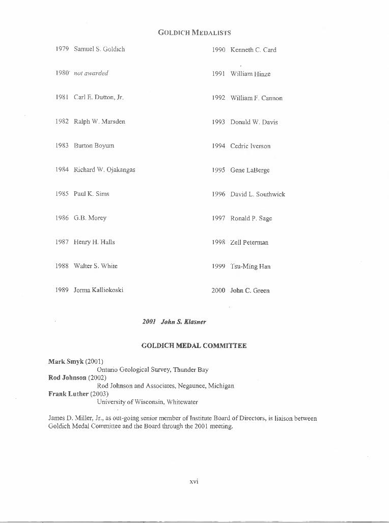
GOLDICH MEDALISTS
1979 Samuel S. Goldich 1990 Kenneth C. Card
1980 not awarded 1991 William Hinze
1981 Carl E. Dutton, Jr. 1992 William F. Cannon
1982 Ralph W. Marsden 1993 Donald W. Davis
1983 Burton Boyum 1994 Cedric Iverson
1984 Richard W. Ojakangas 1995 Gene LaBerge
1985 Paul K. Sims 1996 David L. Southwick
1986 G.B.Morey 1997 RonaldP.Sage
1987 Henry H. Halls 1998 Zell Peterman
1988 Walter S. White 1999 Tsu-Ming Han
1989 Jorma Kalliokoski 2000 John C. Green
2001 John S. Kiasner
GOLDICH MEDAL COMMITTEE
Mark Smyk (2001)Ontario Geological Survey, Thunder Bay
Rod Johnson (2002)Rod Johnson and Associates, Negaunee, Michigan
Frank Luther (2003)University of Wisconsin, Whitewater
James D. Miller, Jr., as out-going senior member of Institute Board of Directors, is liaison betweenGoldich Medal Committee and the Board through the 2001 meeting.
xvi

CITATION FOR JOHN S. KLASNER2001 G0LDICH AWARD RECIPIENT
It is my distinct honor and privilege to present this citation for John Klasner, the 22 recipient of theGoldich Award. John was born and raised in the Upper Peninsula. He received his Bachelor's degree in1957 from Michigan State. His first professional job was with [NCO in the bush of northern Ontario in thesummer of 1957. From 1958 to 1962, John worked for Geophysical Services International reducing seismicdata for petroleum exploration in New Mexico, Texas, Wyoming, and then overseas in Libya and Muscat.He returned to Michigan State in 1962 and earned a Master's degree in geophysics in 1964. His thesis,mapping a bedrock valley by gravity methods was sponsored by the Groundwater Branch of the U.S.G.S.For the next five years, John worked for the Standard Oil Company of California as an explorationgeophysicist stationed mainly in Anchorage, Alaska. He worked in the Cook Inlet area, and while inAnchorage, he met and married his wife, Gretchen, who also happens to be from the U.P. of Michigan. Heworked in California from 1967 to 1969, and was then transferred back to Alaska in 1969 to work on theNorth Slope oil project.
In the fall of 1969, he left Standard Oil to work on a Ph.D. at Michigan Tech., under Jo Kalliokoski.His dissertation was on the structure and metamorphism in the western Marquette range. I believe thatJohn's thesis was the first study to show that the Early Proteozoic rocks are detached from the Archean in thearea, suggesting large-scale horizontal tectonics. Upon completion of his Ph.D. in 1972, John joined thefaculty at Western Illinois University, where he taught for 27 years. He resumed his contact with theU.S.G.S. spending summers mapping in northern Michigan. John as applied his knowledge of geophysic andstructural geology to solving problems in the Precambrian of a number of areas including he Marquette range,the Gogebic range, the Feich trough, several areas in Wisconsin and in the Trans-Hudson Orogeny. He hasdone a broader range of structural studies in the Lake Superior region than anyone I know. He has a long listof publications (49) resulting from his work, in addition to the teaching and administrative load at anundergraduate university. He received the highest awards offered by Western Illinois University for histeaching and research. An indication of the esteem with which he was held at Western is shown by his beingnamed Director of their Honors Program from 1994-1998. He introduced many students to the mysteries ofhe Precambrian by leading a field trip to the area every year. Especially important, I think, has been his roleof introducing undergraduate students to professional activities by supervising fourteen Senior theses and sixHonors theses during his years of teaching at Western.
I have had the privilege of working directly with John since the mid-i 980s, doing field work inWisconsin and northern Michigan. During this time John has been the mentor for a number ofNAGGED/USES Summer trainees and volunteers. I have found John to be an exceptionally dedicatedteacher of young geologists, as well as being a very competent geologist himself, a very good woodsman, anda pleasant fellow to work with. Therefore, it is with great pleasure that I present the 2001 recipient of theGoldich Award for "Outstanding Contributions To The Geology Of The Lake Superior Region", John S.Klasner.
Gene L. LaBerge
xvii

EISENBREY STUDENT TRAVEL AWARDS
The 1986 Board of Directors established the ILSG Student Travel Awards to support student participation at theannual meeting of the Institute. The name "Eisenbrey" was added to the award in 1998 to honor Edward H.Eisenbrey (1926-1985) and utilize substantial contributions made to the 1996 Institute meeting in his name.'Ned" Eisenbrey is credited with discovery of significant volcanogenic massive sulfide deposits in Wisconsin,but his scope as much broader—he has been described as having unique talents as an ore finder, geologist, andteacher. These awards are intended to help defray some of the direct travel costs of attending Institute meetings,and include a waiver of registration fees, but exclude expenses for meals, lodging, and field trip registration. Thenumber of awards and value are determined by the annual Chair in consultation with the Secretary-Treasurer.Recipients will be announced at the annual banquet.
The following general criteria will be considered by the annual Chair, who is responsible for the selection:1) The applicants must have active resident (undergraduate or graduate) student status at the time ofthe annual meeting of the Institute, certified by the department head.2) Students who are the senior author on either an oral or poster paper will be given favoredconsideration.3) It is desirable for two or more students to jointly request travel assistance.4) In general, priority will be given to those in the Institute region who are farthest away from themeeting location.5) Each travel award request shall be made in writing to the annual Chair, and should explain need,student and author status, and other significant details. The form below is optional.
Successful applicants will receive their awards during the meeting.
INSTITUTE ONLAIE SUPERIOR GEOLOGY
enbrey Student Travel Award Application
Student Name:
_______________________________
Date.
Address:
DpartmentHead-Tjped
EducationalStatns:__________________ Department Head-Si gnature
Are you the senior author of an oral or poster paper? YES_ NO___
Will any other students be traveling with you? Who?
_____________
Statement of need (use additi onal page Efnecessary)
___________
Please rdurn to:
xviii

STUDENT PAPER AWARDS
Each year, the Institute selects the best of the student presentations and honors presenters with a monetaryaward. Funding for the award is generated from registrations of the annual meeting. The Student PaperCommittee is appointed by the annual meeting Chair in such a manner as to represent a broad range ofprofessional and geologic expertise. Criteria for best student paper—last modified by the Board in1997—follow:
1) The contribution must be demonstrably the work of the student.
2) The student must present the contribution in-person.
3) The Student Paper Committee shall decide how many awards to grant, and whether or not to give separateawards for poster vs. oral presentations.
4) In cases of multiple student authors, the award will be made to the senior author, or the award will beshared equally by all authors of the contribution.
5) The total amount of the awards is left to the discretion of the meeting Chair and Secretary-Treasurer, buttypically is in the amount of about $300 US.
6) The Secretary-Treasurer maintains, and will supply to the Committee, a form for the numerical ranking ofpresentations. This form was created and modified by Student Paper Committees over several years in aneffort to reduce the difficulties that may arise from selection by raters of diverse background. The use of theform is not required, but is left to the discretion of the Committee.
7) The names of award recipients shall be included as part of the annual Chair's report that appears in thenext volume of the Institute.
Student papers will be noted on the Program.
STUDENT PAPER AWARDS COMMITTEE
Dave Meineke - Committee ChairMenden Engineering LLC
Anne ArgastIndiana University - Purdue University Fort Wayne
Thomas J. EvansWisconsin Geological and Natural History Survey
Steve KircherNicolet Minerals
xix

MEMBERSHIP CRITERIAFOR THE INSTITUTE ON LAKE SUPERIOR GEOLOGY
Approved May 8, 1997
A. Membership in the Institute on Lake Superior Geology requires either participation in Institute activities,or an indication on a regular basis of interest in the Institute. Those individuals registering for an annualmeeting will remain as members for 4 years unless: 1) they indicate no further interest in the Institute byresponding negatively to the statement on meeting circulars "Remove my name from the mailing list"; or 2)two successive mailings in different years are returned by the postal service as address unknown.
B. Those individuals who have not registered for an annual meeting in the past 4 years must indicate aninterest in the Institute by postal, electronic , or verbal correspondence with the Secretary-Treasurer at leastonce every two years. Such individuals will be removed from the membership if they indicate no furtherinterest in the Institute or two successive mailing in different years are returned by the postal service asaddress unknown.
C. The Secretary-Treasurer will maintain a list of current members. The list will include the date of thebeginning of continuous membership, dates of returned mail, dates of last contact (expression of interest),and the date membership expires, barring a change of status initiated by the member. Those individuals whohave become members of ILSG by Section B will have an expiration date listed at 2 years from the upcomingmeeting. For example, a member who expresses interest in September of 1997 (the next annual meeting isMay, 1998) will have an expiration date of May, 2000, unless the member contacts the Secretary-Treasurer orattends an annual meeting.
D. "Member for Life" status is granted to individuals who have been (nearly) continuous participants of theILSG meetings for 15 years, Goldich Medal recipients, or those who have served as meeting chairs. Thisstatus will be further maintained unless the individuals indicate no further interest in the Institute, or 4mailings in different years are returned by the postal service as address unknown, or they are deceased.
E. All members will be mailed the First Circular for the Annual Meeting and the ILSG Newsletter. TheChair of the annual meeting may opt to send the first circular to additional individuals. All returned mailshould be reported to the Secretary-Treasurer.
F. The Secretary-Treasurer can designate any individual who is on the ILSG membership list (mailing list) asof January 1, 1997 as a member for life based on participation in ILSG activities.
G: Members are strongly encourage to send address corrections to the Secretary-Treasurer to avoidunintentional lapse of membership.
xx

2001 BOARD OF DIRECTORS(Board membership through the close of the meeting year shown)
Michael G. Mudrey, Jr., General Chairman (2004)Bruce A. Brown, Co-chair
Wisconsin Geological and Natural History Survey
Stephen A. Kissin (2003)Lakehead University
Theodore J.Bornhorst (2002)Michigan Technological Univensty
James D. Miller, Jr. (2001) Goldich LiaisonMinnesota Geological Survey
Mark A. Jirsa - Executive Secretary (2002)Minnesota Geological Survey
2001 LOCAL PLANNING COMMITTEE
Michael G. Mudrey, Jr. - Co-chairBruce A. Brown - Co-chair
Robert H. Dott, Jr. - Program Co-chairL. Gordon Medaris, Jr. - Program Co-chair
Kathleen M. Zwettler - Meeting Coordinator
Assistance to the local committee was provided by the following individuals from the Wisconsin Geologicaland Natural History Survey:
James M. RobertsonDirector and State Geologist - Wisconsin Geological and Natural History Survey
Virginia TrapinoOffice Support
Mindy JamesPublication Preparation
Susan HuntGraphic Arts
Michael L. CzechanskiProgram and Technical Assistance
xxi

2001 SEssioN CHAIRS(In order of appearance)
James M. Robertson - Geologic Overview of Southern WisconsinWisconsin Geological and Natural History Survey
D.L. Daniels - Geophysical Overview and Earliest Archean EvolutionU.S. Geological Survey
William F. Cannon - Geology and Hydrogeology ofArsenic in Domestic and Public Water SuppliesU.S. Geological Survey
Michael D. Lemcke - Geology and Hydrogeology of Arsenic in Domestic and Public Water SuppliesWisconsin Department of Natural Resources
Suzanne W. Nicholson - General GeologyU.S. Geological Survey
Dean Rossell - Developments in Understanding Keweenawan GeologyKennecott Exploration Company
D.K. HoIm - Thermo-Tectonic History of 1800 to 1200 Ma post-Penokean to Pre-Keweenawan RocksBowling Green State University
D.A. Schneider - Thermo- Tectonic History of 1800 to 1200 Ma post-Penokean to Pre-Keweenawan RocksSyracuse University
Eric Jerde - Developments in Understanding Archean Geology and Ore Depo.itsMorehead State University
2001 BANQUET SPEAKER
Thomas C. HuntUniversity of Wisconsin - Platteville
A Practical Exercise in Metallic Mine Reclamation - Ladysmith, Wisconsin
xxii

REPORT ON THE 46TH ANNUAL MEETINGOF THE INSTITUTE ON LAKE SUPERIOR GEOLOGY
Thunder Bay, Ontario
The 46tl Annual Meeting ofthe Institute on Lake Superior Geology was held in Thunder Bay, Ontario, May 8-13,2000, at Lakehead University. The meeting was sponsored by the Department of Geology, Lakehead University,with the assistance of the Ministry of Northern Development and Mines, Thunder Bay office. The meeting wasco-chaired by Stephen A. Kissin and Philip W. Fralick. The meeting was attended by approximately 200geoscientists from the United States and Canada. The meeting consisted of two days of technical sessions, withwelcoming reception and annual banquet, and after six field trips before and after the technical sessions.
The Proceedings Volume 46 was published in two parts. Part 1 - Program and Abstracts was edited by StephenA. Kissin. There were 41 published abstracts for the 23 oral and 18 poster presentations given in the technicalsessions. Part 2 - Field Trips was edited by Philip W. Fralick. There were six field trips, one before and afterthe technical sessions; all were described by the respective leaders in Part 2 of the Proceedings.
The field trips were as follows:1) Mesoproterozoic Sibley Group was lead by Philip Fralick and Mark Smyk. This was a two day trip.2) Lac des Iles Mine was lead by Moe Lavigne. The trip was run before and after the technical sessions.3) Geoarcheology of the Thunder Bay Area was lead by Brian Phillips, Scott Hamilton, Joe Stewart, Pat
Julig, and Bill Ross.4) Paleoproterozoic Gunflint Formation was lead by Peir Pufahl and Philip Fralick.5) Quaternaiy Geology, Shebandowan Belt was lead by Andy Bajc.6) Steeprock-Finlayson-Lumby Belts, a two day trip was lead by Denver Stone, Kirsty Tomlinson, Ray
Bernatchez and Philip Fralick.
The annual banquet was held in the Residence Dining Room at Lakehead University. The dinner speaker wasBruce Simonson of Oberlin College whose talk "Depositional Settings and Early Diagenesis of LargePrecambrian Iron-Formations" was enthusiastically received. The 2000 Goldich Medal was awarded to John C.Green for his contributions to the geology of the North Shore Volcanic Group.
The technical sessions included seven invited papers on the Canadian side of Lake Superior: M.M. Kehlenbeck"A Review of Structures in Rocks of Quetico Subprovence and Adjacent Terranes", D.W. Davis "WesternSuperior Province: Geochronologic Aspects", K. Tomlinson "Western Superior Provence: SedimentologicalAspects", M.J. Lavigne "The Lac des Ties Mine, Northwestern Ontario", P.W. Fralick "Western SuperiorProvince: Proterozoic Sediments", and S.A. Kissin "Vein-type Deposits of the Thunder Bay Area". Studentawards were given to Neil Pettigrew (University of Ottawa) for his oral presentation on the Samuels Lakeintrusion, Ontario and to K.F. Beaster and J.D. Kohn (University of Wisconsin-Eau Claire) for their posterpresentation on the Hinckley Sandstone of Minnesota. The Eisenbrey Student Travel Award was distributedamong eight student presenters of oral and poster papers.
The Board of Directors of the Institute met for a brief business meeting on May 10. Michael Mudrey of theWisconsin Geological and Natural History Survey agreed to host the 2001 meeting at Madison, Wisconsin. Theterm of the Secretary-Treasurer, Mark Jirsa, expired at this meeting. He was nominated for an additional termas Secretary-Treasurer. There being no further nominations, he was acclaimed for an additional term.
We wish to thank all those who contributed to the success of the meeting. The field trip leaders who contributedto the guidebook in Part 2 and devoted time and energy to field trips merit our special thanks. The session chairsare thanked for their services as well as the awards committee. We are especially grateful to Mark Smyk and staffof the Ministry of Northern Development and Mines, Sam Spivak, Karen Farrier, Becky Rogola and FranceLagroix of the Department of Geology for invaluable assistance. Finally we would like to thank all participantswhose attendance made the meeting a financial success.
Stephen A. Kissin and Philip W. FralickCo-Chairs of the 46th Annual ILSG
xxiii

CALENDAR OF EVENTS AND PROGRAM
WEDNESDAY MAY 9
8:00 am. FIELD TRIP 1: Sedimenlology, Tectonic and Metamorphic History of the Baraboo Interval:New Evidence from Investigations in the Baraboo Range, Wisconsin
L.Gordon Medans, Jr. and Robert. H. Dott, Jr.University of Wisconsin - Madison
6:00 p.m. Return of Trip 15:00 p.m. - 8:00 p.m. Registration7:00 p.m. - 10:00 p.m. Welcoming Reception, Cash bar and Poster Setup
THURSDAY MAY 10
7:00 a.m. - 9:00 a.m. REGISTRATION
8:10 a.m. INTRODUCTORYREMARKS
M.G. Mudrey, Jr. ChairmanWisconsin Geological and Natural History Survey
SESSION I: GEOLOGIC OVERVIEW OF SOUTHERN WISCONSINSession Chair: J.M. Robertson, Director and State Geologist, Wisconsin Geological and
Natural History Survey
8:20 a.m. MICKELSON, D.M. and Clayton, L., (University of Wisconsin - Madison;Wisconsin Geological & Natural History Survey)
Recent Advances in Understanding the Glacial Record of Wisconsin
9:05 a.m. BYERS, C.E. (University of Wisconsin - Madison)Overview of Paleozoic Geology in Southern Wisconsin
9:50 a.m. MEDARIS, L.G., Jr. (University of Wisconsin - Madison)Precambrian Geology of S. Wisconsin: A Panorama from the Baraboo Range
10:35 a.m. COFFEEBREAK AND POSTER SESSION
SESSION II: GEOPHYSICAL OVERVIEW AND EARLIEST ARCHEAN EVOLUTIONSession Chair: D. Daniels, US. Geological Survey
10:55 a.m. CHANDLER, Val W. and MUDREY, M.G., JR.Overview of Aeromagnetic Mapping: Minnesota (Chandler) and Wisconsin (Mudrey)
11:20 a.m. CANNON, W.F., Daniels, David L., Snyder, Stephen L., and Nicholson, Suzanne W.A Preliminary Interpretation of New Aeromagnetic and Gravity Data in Wisconsin
11:40 a.m. VALLEY, J.W., Peck, W.H., King, E.M, Graham, C.M., and Wilde, S.A.The Cool Early Earth: Oxygen isotope Evidence for Continental Crust and Oceans on Earth at4.4 Ga
NOON LUNCH BREAK
ILSG BOARD MEETING (by invitation)POSTER SESSION
xxiv

SESSION III: GEOLOGY AND HYDROGEOLOGY OF ARSENIC IN DOMESTIC AND PUBLIC WATERSUPPLIES
Session Chairs: W.F. Cannon (U.S. Geological Survey)M.D. Lemcke (Wisconsin Department of Natural Resources)
1:30 p.m. NORDSTROM, D. Kirk (US. Geological Survey)Overview of Arsenic Occurrences and Processes in Controlling Mobility in Groundwater
2:30 p.m. MUDREY, M.G., Jr., Brown, B.A., Freiberg P.G., and Simo, J.A.Mississippi Valley-Type Mineralization in the Fox River Valley, Eastern Wisconsin
2:45 p.m. GOTKOWITZ, M.B., Schreiber, M.E., and Simo, J.A.Contrasts in the Geologic and Hydrochemical Occurrences of Arsenic contamination ofGroundwater in Eastern Wisconsin
3:05 p.m. KANIVETSKY, Romanilydrogeochemical Modeling of Arsenic in Minnesota Ground Water
3:25 p.m. KOLKER, Allan, Cannon, W.F., Haack, S.K., Westjohn, D.B. and Woodruff, L.G.Hydrogeologic Setting of Elevated Arsenic in Southeastern Michigan
3:45 p.m. COFFEE BREAK AND POSTER SESSION
SESSION IV: GENERAL GEOLOGYSession Chair: Suzanne W. Nicholson, US. Geological Survey
4:05 p.m. WOODRUFF, L.G., Attig, J.W., and Cannon, W.F.Geochemistry of Quaternary Deposits in North-central Wisconsin: Geochemical Exploration andProvenance Analysis
4:25 p.m. FAUBLE, Philip, and Lien, JenniferSome Observations from the Williams Quarry Exposure: Evidence of Debris Flow Deposits inthe Parfeys Glen Formation?
4:45 p.m. BOERBOOM, Terrence J. and Jirsa, Mark A.Stratigraphy of the Paleoproterozoic Denham Formation - a Continental Margin Assemblage ofBasalt, Arkose, and Dolomite
6:00 p.m. ICE BREAKER - MIXERCash Bar
7:00 p.m. ANNUAL BANQUET AND AWARD PRESENTATION• Announcement of 48th Annual Meeting Location• Memorial on Samuel Stephen Goldich 1909 - 2000
• 2001 Goldich Award Presentation to John Kiasner• Banquet Speaker: Thomas Hunt, University of Wisconsin Platteville
A Practical Exercise in Metallic MineReclamation - Ladysmith, Wisconsin
Participants who are not registered for the banquet are welcome to join for the speaker
xxv

FRIDAY MAY 11
8:10 a.m. INTRODUCTORYREMARKS
M.G. Mudrey, Jr. ChairmanWisconsin Geological and Natural History Survey
SESSION V: DEVELOPMENTS IN UNDERSTANDING KEWEENA WAN GEOLOGYSession Chair: Dean Rossell, Ken necott Exploration Company
8:20 a.m. MILLER, James D., Jr.The Duluth Complex: What it Is, What it Ain't, and What We Still Don't Know
8:50 a.m. GREEN, J.C., Davis, D.W., and Schmitz, M.D.Three New Zircon Dates for the Midcontinent Rift, North Shore, Minnesota: More Data, MoreQuestions
9:10 a.m. ROGALA, B., and Fralick, P.W.A Metamorphosed Evaponte Sequence from the Sibley Basin
SESSIoN VI: THERMO-TECTONIC HISTORY OF 1800 TO 1200 MA POST-PENOKEAN TO PRE-KEWEENA WANROCKS IN THE MIDWESTSession Chairs: D.K. Holm, Kent State University
D.A. Schneider, Syracuse University
9:30 a.m. HOLM, D.K., Van Schmus, W.R. and MacNeill, L.C.Age of the Humboldt granite, northern Michigan: Implications for the origin of the Republicmetamorphic node
9:50 a.m. VAN SCHMUS, W.R., MacNeill, L.C., Hoim, D.K., and Boerboom, T.J.New U-Pb Ages from Minnesota, Michigan, and Wisconsin: Implications for LatePaleoproterozoic Crustal Stabilization
10:10 a.m. COFFEEBREAK AND POSTER SESSION
10:30 a.m. SCHWEITZER, D., Hoim, D., Van Schmus, W.R. and Boerboom, T.Results of Igneous Thermometry and Barometry on the East-central Minnesota Batholith:Evidence for Post-emplacement Exhumation and Cooling
10:50 a.m. NAYMARK, Alissa, Singer, Brad, and Medaris, L.G., Jr., Recognition of Post-1630 Ma Fluid-driven Metamorphism in Baraboo Interval Quartzites by Means of Laser Probe 40Ar/39ArGeochronology
11:10 am. DAVIS, Peter B., Williams, Michael L., Bownng, Samuel A. and Ramezani, JahanMiddle Proterozoic Tectonic History of the Central Tusas Mountains, Northern New Mexico,and Comparison with the Baraboo Interval, Southern Lake Superior Region
11:30 a.m. WILLIAMS, M.L., Jercinovic, M.J., and Karlstrom, K.E.Proterozoic Tectonic History of Southwestern North America: Insight from MicroprobeMonazite Geochronology
11:50 a.m. HOLM, D., Jercinovic, M.M., and Williams, M.Initial Results of In Situ electron Microprobe (EMP) Age Dating of Monazite from the SouthernLake Superior Region: Confirmation of Widespread Geon 17 Metamorphism
xxvi

12:10 p.m. SCHNEIDER, D.A., Hoim, D.K., and Hamilton, M.A.Directing Timing Constraints of Paleoproterozoic Metamorphism, Southern Lake Superior
_____
Region: Results from Shrimp U-Pb Dating of Metamorphic Monazites
12:30 LUNcH BREAK
POSTERS removed after Lunch
SESSION VII: DEVELOPMENTS IN UNDERSTANDING ARCHEAN GEOLOGYAND ORE DEPOSITS
Session Chair: Eric Jerde, Morehead State University
2:00 p.m. HUDAK, George J., Peterson, Dean M., and Morton, Ronald L.New Volume Calculations for the Pyroclastic Eruptions Associated with the Sturgeon Lake
Caldera Complex, Northwestern Ontario: Implications for the Scale of Archean Volcanic
Processes
2:20 p.m. PETERSON, D.M., Gallup, C., Jirsa, M.A. and Davis. D.W.
Correlation of Archean Assemblages Across the U.S.-Canadian Border: Phase I Geochronology
2:40 p.m. JIRSA, Mark A. and Chandler, Val W.
Geophysical Answers to Geologic Queries in the Superior Province of Northern Minnesota
3:00 p.m. SMYK, Mark C., Mason, John K., Schnieders, Bernie R., and Stott, Greg M.A Synopsis of Archean and Proterozoic Platinum Group Element Mineralization in the ThunderBay District, Ontario
3:20 p.m. COFFEEBREAK
SESSION VIII: GEOLOGIC SETTINGS OF WEEKEND FIELD TRIPS
3:40 p.m. MUDREY, M.G., Jr., Hunt, T.C., and Czechanski, M.L.Overview of Field Trip 2: Upper Mississippi Valley Zinc-Lead District
4:00 p.m. BROWN, B.A., Luther, F.R., Courter, S.M., Schmitt, J.W., and Lien, 3.
Field Trip 3: Economic Geology of the Baraboo and Waterloo Quartzites
5:00 p.m. SINGER, Brad (Department of Geology and Geophysics)Tour of Weeks Hall, University of Wisconsin and Weeks End Refreshment Seminar
(Transportation provided)
SATURDAY MAY 12
8:00 a.m. FIELD TRIP 2: Upper Mississippi Valley Zinc-Lead DistrictM.G. Mudrey, Jr. and Thomas C. HuntWisconsin Geological and Natural History Survey and University of Wisconsin - Platteville
8:00 a.m. FIELD TRIP 3: Industrial Mineral and Aggregate Resources of the Baraboo Interval QuartzitesBrown, B.A., Luther, F.R., Courter, S.M., Schmitt, J.W., and Lien, 3.Wisconsin Geological and Natural History Survey, University of Wisconsin - Whitewater, MathyConstruction, Kraemer Company
6:00 p.m. Return of Field Trips
xxvii

POSTER PRESENTATIONS
BESKAR, ShawnThe Blake Gabbro: A taxitic-tectured gabbro sill south of Thunder Bay, Ontario
BIHARI, D.B. and Kissin, S.A.Alteration and Pge-au Mineralization in the North Roby Zone, Lac Des lies Mine, NorthwesternOntario
BOERBOOM, Terrence J.Redefined Volcanic and Sedimentary Stratigraphy of the Northern St. Croix Horst in Pine County,Minnesota, and the Application of Arcview to Geologic Mapping
BROWN, B.A. and Czechanski, M.L.GIS Applications for Resource Inventory and Land-use Planning in Wisconsin
BUCHHOLZ, Thomas W., Faister, Alexander U., and Simmons, Wm. B.Recent Developments in the Mineralogy of the Nine Mile Piuton, Wausau Complex
CANNON, W.F. and Woodruff, L.G.Regional Arsenic Anomalies Shown by NURE Stream Sediment and Hydrogeochemical Data inNorthern Wisconsin and Michigan
CHANDLER, Val W. and Morey, G.B.Paleomagnetic Study of Paleoproterozoic Rocks in the Animikie Group, Northern Minnesota
DAHL, D.Structure, Stratigraphy and Punctuated Evolution of Minnesota's Mineral Exploration Archives
DANIELS, David L., Nicholson, Suzanne W., Cannon, William F., and Kucks, Robert P.New Aeromagnetic Map of Wisconsin Examined by Regional Context
Jerde, Eric A., SAL VATO, DanielJ., Thole, Jeff and Wirth, Karl R.The Early Gabbroic Series of the Midcontinent Rift System: Continued Assessment of MagmaticOrigins
JOHNSON, DaveDistribution of Arsenic in Wisconsin Groundwater
JOHNSON, J.R. and Kissin, S.A.Fluid Inclusion Evidence for a Role for Hydrothermal Activity in the Roby Zone, Lac Des lies Mine,Northwestern Ontario
KELLY, Colleen, and Kean, William F.Rock Magnetic Studies of Phyllitic Zones from the Baraboo Syncline, Wisconsin
KNOBELOCH, Lynda, Warzecha, Charles. and Nelson, ShelliHealth Surveillance in a Community Affected by Arsenic-Contaminated Water
LARSON, Phillip C.Potential for Copper Mineralization in the Animikie Group, Minnesota
LIVELY, Richard and Morey, G.B.Contributions to the Cultural Geography of the West Mesabi Range, Northern Minnesota
xxviii

MILLER, J.D., Jr., Wahi, T.E., Green, J.C.,Chandler, V.W., Severson, M.A., and Peterson, D.E.Digital Geologic Map of Northeastern Minnesota and Associated Databases in GEMS - a ModifiedArcview Format
MUDREY, M.G., Jr., and Brown, B.A.Structure of the Buried Precambrian Basement in Southwest Wisconsin and Its Influence on RegionalPaleozoic Geology and Zinc-Lead Mineralization
MUDREY, M.G., Jr., Brown, B.A. and Daniels, Daniels L.Preliminary Analysis of Aeromagnetic Data in Southern Wisconsin: The Role of PrecambrianBasement in Paleozoic Evolution
NEMITZ, Michael B. and Larson, Phillip C.Mineralogical Variations in Iron-formation in the Thermal Metamorphic Aureole of a Diabase Dike
NEWKIRK, Trent T., Hudak, George J., and Hauck, Steven A.Preliminary Lava Flow Morphology Studies at the Five Mile Lake Vms Prospect, Archean VermilionDistrict, Ne Minnesota: Implications for Volcanic Processes, Volcanic Paleoenvironments, and VMSExploration
NICHOLSON, S.,W., Boerboom, T., Cannon, W.F., Wirth, K., and Isachsen, C.E.A New Look at the 1.1. Ga Chengwatana Volcanics in the St. Croix Horst, Minnesota and Wisconsin
ODETTE, Jason D., Hudak, George J., Suszek, Thomas, and Hauck, Steven A.Preliminary Evaluation of Hydrothermal Alteration Mineral Assemblages and Their Relationship toVMS-style Mineralization in the Five Mile Lake Area of the Archean Vermilion Greenstone Belt,Northeastern Minnesota
PETERSON, Dean M., Gallup, Christina, Jirsa, Mark A. and Davis. Donald W.Correlation of Archean Assemblages Across the U.S.-Canadian Border: Phase I Geochronology
PEYCHAL, C., Kean, W.F., and Schaper, D.Magnetic Survey Near Waterloo Wisconsin
PHILLIPS, Erin H., Wirth, Karl R., Veroort, J.D. Gehrels, G.E.Nd and U-Pb Isotope Studies of the Syenitic Aurora Sill, Mesabi Range, Minnesota
REID, Daniel D.Freeze/Thaw Testing of Carbonate Aggregate Sources in Wisconsin - a Status Report
SANDLAND, Travis 0., Wirth, Karl R., Vervoort, Jeff D., Gehrels, George E., Kennedy, BryanC. and Harpp, Karen S.Roles of Fractional Crystallization and Assimilation in the Production of Midcontinent Rift Grano-phyres
SMYK, Mark C., Stewart, Jennifer and O'Brien, Mark S.Platinum Group Element Exploration in Northwestern Ontario
SNYDER, Stephen L., Ervin, C.Patrick, Geister, Daniel W., and Daniels, David L.A New Gravity Map of Wisconsin
SOOFI, M.A. and King, S.D.Post-rift Evolution of the Midcontinent Rift System: Some Numerical Experiments
Weissbach, Annette E., HEINEN Elizabeth M., and Lauridsen, Keld B.A Study of Well Construction for Arsenic Contamination in Northeast Wisconsin
xxix
Industry and Informational Displays
CRONK, William J.Layne Northwest, W229 N5005 DuPlainville Rd, Pewaukee, WI 53072. Phone (262)-246-4646
KIRCHER, SteveCrandon Mine Development, Nicolet Minerals, 7 N. Brown St, 3rd Floor, Rhinelander, WI 54501.Phone (715)365-1450 (Rhinelander office), (715)478-1516 (Crandon office)
STEWART, JenniferOntario Geological Survey Resident Geologist Program, Northwestern Ontario District, Suite B002,475 South James Street, Thunder Bay ON, P7E 6E3. Phone (807) 475-1108
SUNDEEN, S. PaulMichigan Department of Environmental Quality, Geological Survey Division, 735 E. Hazel Street,P.O. Box 30256, Lansing, MI 48909. Phone(517) 334-6959.
xxx

The Blake Gabbro: A taxitic-textured gabbro sill south of Thunder Bay, Ontario.
Shawn Beskar - University of St. Thomas
South of Thunder Bay, Ontario, plutonic and hypabyssal rocks associated with the Keweenawan Rift (1109 Ma to1086 Ma) intrude sedimentary rocks of the Lower Proterozoic (1.9 Ga) Animikie Group. Prior to the discovery ofthe Blake Gabbro, the igneous terrane south of Thunder Bay was thought to have been comprised of five distinctintrusions (Lightfoot and Lavigne, 1995): (1) Logan Sills; (2) Arrow River Dikes; (3) Pigeon River Dikes; (4)Crystal Lake Gabbro; (5) Pine River - Mount Molly Intrusion.
Discovered in 1995, the Blake Gabbro is situated south of Thunder Bay within Blake Township, some 60 km northof the Duluth Complex. The region is characterized by northeast trending diabase-capped ridges and deeply erodedvalleys. Positioned beneath a sequence of flat lying Logan Sills, the Blake Gabbro intrudes the argillites of the RoveFormation (Animikie Group). Since 1995, diamond drill cores that intersect the Blake Gabbro have been recoveredand logged. From these cores it has been determined that the Blake Gabbro is a northeast trending, sub-horizontalsill of limited plan width but unknown strike length. The maximum thickness intersected by holes drilled thus far is131 m. The sill thins to less than 20 mat its margins, some 300 m from the center of the body.
Samples of the Blake Gabbro have been taken from the diamond drill cores for petrologic study. Initial studiesindicate that the Blake Gabbro is a taxitic-textured sulphide-bearing sill. Plagioclase and pyroxene are present inroughly equal quantities. Elongate, cumulus plagioclase grains of variable size are enclosed by optically continuousintercumulus pyroxene. Initial analyses of plagioclase yield compositions ranging from An72 to An83. Minoramounts of olivine and biotite are present. Sulphide minerals consist of pyrrhotite and chalcopyrite. Preliminarywhole-rock geochemical data obtained through XRF spectroscopy is presented in Table 1.
The significance of the Blake Gabbro is realized upon comparison with the igneous terrane of Noril'sk, Siberia. Theregion south of Thunder Bay is thought to be equivalent in many respects to the geologic setting of the Noril'skregion and as such, may host large magmatic sulphide deposits (Lightfoot and Lavigne, 1995). The KeweenawanOsler Group Volcanic rocks are similar in composition to the Nadezhdinsky Formation lavas at Noril'sk. Bothexhibit large degrees of crustal contamination (as evidenced by their high silica content and LaJSm ratio) and aredepleted in nickel and copper. At Noril'sk, chonoliths (subvolcanic tube-like magma channels) containingmineralized picrites and gabbros served as feeders to the overlying sequence of flood basalt. It is thought that theBlake Gabbro may represent such a conduit. Chalcophile elements (nickel, copper and platinum group metals)missing from the associated Osler Group Volcanic sequence may reside within the Blake Gabbro, although thepreliminary geochemical data presented seems to suggest otherwise.
REFRENCES
Lightfoot, P.C. and Lavigne, Jr., M.J. 1995. Nickel, copper, and platinum group element mineralization inKeweenawan intrusive rocks: new targets in the Keweenawan of the Thunder Bay region, northwestern Ontario:Ontario Geological Survey, Open File Report 5928, 32p.
1

Table 1. Preliminary whole-rock geochemistryMajor element data presented as weight per centTrace element data presented as parts per million
BP98.1-1 BP99.1-2 BP99.2-1 BP99.3-2 BP99.3-3
Si02 51.42 49.29 48.54 52.00 51.18
Ti02 3.38 1.43 1.27 2.95 3.48
A1203 13.84 18.52 15.18 13.65 13.97
Fe203 17.09 10.91 11.14 16.15 16.54
MnO 0.17 0.14 0.14 0.15 0.16
MgO 4.44 6.72 10.16 4.62 4.92
CaO 6.76 10.85 9.11 6.68 6.99
Na20 2.97 2.81 1.58 2.67 2.70
1(20 1.35 0.66 0.61 1.38 1.33
P205 0.59 0.25 0.18 0.44 0.48
Total 102.01 101.58 97.91 100.69 101.75
Sc 23.5 25.6 25.2 25.8 26
V 337.5 224 200.9 343.9 396.8
Cr 51.8 157.1 104.8 63.1 48.9
Co 46.1 46.7 58 47.5 45.9
Ni 67 121.1 207 79.2 74.5
Zn 162.5 82.9 90.6 172.9 144.9
Ga 25.6 20.9 19.5 23.9 24.1
Rb 54.9 23.2 29.3 61.3 60.8
Sr 425 306.6 348.8 447.4 501.8
Y 42.4 23.5 20.4 36.2 36
Zr 277.8 101.7 87.3 243.6 233.5
Nb 30.8 9.7 9.5 27.4 28.9
Ba 337.7 167.4 189.3 390.9 442.8
La 32.4 6.6 4.2 32.3 24.8
Ce 79.5 26.6 25.6 77.3 68.7
Pb 7.5 3.9 3 10.1 6.7
2

ALTERATION AND PGE-AU MINERALIZATION IN THE NORTH ROBYZONE, LAC DES ILES MINE, NORTHWESTERN ONTARIO
BIHARI, D.B. and KISS1N, S.A., Department of Geology, Lakehead University, Thunder Bay, ON,P7B 5E 1, stephen.kissin(Z)lakeheadu.ca
The Lac des Ties Complex appears as a linear zone of mafic plutons that trend east to northeast andextends from Lake Nipigon to Atikokan in northwestern Ontario (Sutcliffe, 1986). The complex issituated in Archean granitoids that consist of gneissic tonalites, medium-grained hornblende diorites
and quartz diorites. The Lac des lies Complex occurs in a circular outcrop fashion that isapproximately 30 km in diameter and is the largest of a series of mafic to ultramafic intrusions(Sutcliffe, 1986). The Roby Zone was the initial site of mining at the Lac des Iles Mine. The NorthRoby Zone is its narrow northward extension.
The North Roby Zone contains a narrow strip (<50 m) of anomalously high PGE and Auvalues associated with sparse sulfides called "noseeum ore". Five stripped outcrops approximately50 x 10 m were studied in the North Roby Zone. Alteration of primary pyroxene to talc and pinkcoloration of recessively weathered plagioclase is strongly suggestive of hydrothermal alteration.
The five stripped outcrops reveal a northeasterly striking, steeply dipping sequence ofleucogabbro, varitextured gabbro, pyroxenite and east gabbro. A total of 32 hand samples werecollected and studied in thin section. From these 21 were selected for whole-rock and trace elementanalysis in order to compare chemistry of altered and unaltered samples.
Hydrothermal alteration appears to have affected the primary ortho- and clinopyroxenes ofthe host rocks, progressively converting them to talc. Other petrographic indications are obscure,
as regional metamorphism has overprinted the Lac des Iles Complex and its mineralized rocks.The grade of metamorphism is the albite-epidote subfacies of greenschist facies as evidence
by incipient breakdown of plagioclase to sericite and clinozoisite, chioritization of pyroxenes andformation of tremolite-actinolite, as well as minor metamorphic albite. Chlorite coronas surroundmafic minerals, and develops decussate assemblages of chlorite and tremolite-actinolite. Minorpenetrative deformation is evident in undulatory extinction in plagioclase and development of weak
schistosity.The development chlorite coronas and general overprinting ofmafic minerals by chlorite and
sericitization ofplagioclase are significant in distinguishing hydrothermalalteration from subsequent
regional metamorphism.Analysis did not generally reveal striking compositional variations in the host rocks;
however, more detailed analysis did show chemical effects ofalteration. Chondrite-normalized REEplots revealed that all REEs were depleted relative to unaltered rocks; however, in most alteredleucogabbro and varitextured gabbro, minor to insignificant depletion of Eu relative to other REEs
produced an apparent positive Eu anomaly in the plots.Other chemical changes, because of their subtle expression and obscurity owing the problem
of closure, were examined by use of Pearce Element Ratios. Most notable was Na-depletion due to
alteration, which can be distinguished from igneous fractionation effects in plagioclase.
Sutcliffe, R.H., 1989. Magma Mixing in Late Archean Tonalitic and Mafic Rocks of theLac des lies Area, Western Superior Province. Precambrian Research, vol. 44,
pp.81-101.
3

REDEFINED VOLCANIC AND SEDIMENTARY STRATIGRAPHY OF THE NORTHERN ST. CROIX HORSTIN PINE COUNTY, MINNESOTA, AND THE APPLICATION OF ARC VIEW TO GEOLOGIC MAPPING
BOERBOOM, Terrence J.(Minnesota Geological Survey, [email protected])
Pine County, Minnesota, located on the northwestern margin of the St. Croix horst (Fig. 1), contains bedrock that rangesfrom Archean to Pale ozoic in age; however, most of the county is underlain by rocks of the Midcontinent rift (Fig. 2).The southeastern half of the county is underlain by mafic volcanic rocks ofthe St. Croix horst, late rift-filling sedimentaryrocks (Hinckley Sandstone and Fond du Lac Formation) underlie the central part of the county, and the far northwesterncorner is made up of Archean and Paleoproterozoic rocks (see Boerboom, this volume). This county was recentlyremapped by the Minnesota Geological Survey (MGS)', but due to generally poor outcrop, the mapping relied heavilyon geophysical and drill hole data. ArcView GISsoftware proved useful in manipulating and integratingthese data, particularly the 4000 water wells containedin the MGS County Well Index database.
This presentation is intended to demonstrate theusefulness of Arc View software in map construction,and also to show the results of our mapping efforts inPine County. Other Arc files to be demonstrated —
include maps of depth to bedrock, bedrock topography,and surficial geology. I
— -) — St. Croix horstCraddock (1972) provides a review of the history
of investigations in Pine County and environs, butsome of the notable early accounts of the bedrockgeology in Pine County are by Upham (1888) and Hall
________________
(1901); Grout (1910) described the occurrence of Sedimentary rocks
copper mineralization in Pine County. The most recent — Intrusive rocks
published geologic map to cover Pine County is Volcanic rocks1:250,000scale(Moreyandothers, 1981). Ourlatest N / \ Imapping coincides with other mapping projects in Figure 1. Location of Pine County relative to the St. Croix
adjacent Wisconsin (Wirth and others, 1998, Cannon horst and the Mid-continent rift system.
and others, 2001; Nicholson and others, 2001).Geologists on both sides of the border benefited greatly from the recent acquisition of high-resolution aeromagneticdata in Wisconsin by the U.S.G.S., as summarized by Cannon and others (2001).
The St. Croix horst, part of the Mesoproterozoic Midcontinent rift system, is comprised of subaerial mafic volcanicrocks that have traditionally been lumped together as the Chengwatana volcanic group. Based on our work and that ofthe U.S.G.S., the term "Chengwatana" is now restricted only to those volcanic rocks that lie between the Douglas andPine Faults (Fig. 2). The demarcation of Keweenawan sedimentary vs. volcanic rocks (i.e. the Douglas Fault) is well-defined on the basis of water well information. The Pine Fault (Fig. 2) lies inboard of and parallel to the Douglas Fault,and as summarized by Cannon and others (2001), may have been a bounding fault that controlled the distribution ofgraben-fill volcanic rocks.
Hall (1901) first applied the term "Chengwatana Series" to a series of steeply dipping basalt flows and interfiowconglomerates exposed along the Snake River near Pine City, Minnesota. According to Hall: "Thefloodofl898, whichtore away the dam at the foot of Cross Lake and poured down the [Snake] river a vast volume of water, cleaned out inan admirable manner for examination the channel of the stream for several miles." In this stretch of outcrop, Hallrecognized 65 steeply dipping lava flows and five interfiow conglomerates. Our remapping of this now less well-exposed sequence identified 37 basalt flows that range from 10 to 300 feet thick, and six interfiow conglomerates thatrange from 10 to 100 feet thick, although a more careful examination might reveal more flows. The interfiowconglomerates contain abundant round boulders of Keweenawan-type granophyric granite and porphyritic basalt froman unknown source. This sequence, the type locality for the Chengwatana volcanic group, dips about 65 degrees east,and starts within a few hundred feet of the Douglas Fault. Other outcrops of the redefined Chengwatana group that areadjacent to the Douglas Fault dip 40 to 70 degrees east, and those near the Pine Fault dip 10 degrees west. This changein dip is consistent with aeromagnetic patterns that indicate the presence of a southward-plunging syncline that merges
4
/1T
Pine

into an unnamed fault (Fig. 2). Hall (190 l)recognized thissyncline on the basis of the change in dip direction.Sedimentary rocks similar to the Fond du Lac Formationare present on top of the horst at the south edge of the county.The Minong volcanics (approximately 1094 Ma; Nicholsonand others, 2001), part of the northeast-plunging AshlandSyncline, lie to the east of the Chengwatana group, and areinterpreted to be younger. The Minong volcanics aredistinguished from an unnamed central pile of volcanic rocksto the north by divergent linear aeromagnetic patterns.Aeromagnetic lineaments imply that the rocks in this centralpanel are folded into a doubly-plunging anticline (Fig. 2).Several aeromagnetically-inferred, reverse-polarizeddiabase dikes cut all three of the volcanic packages in PineCounty.
The Hinckley fault (Fig. 2) is proposed as a splay fromthe Douglas Fault that has displaced the contact betweenthe Hinckley Sandstone and Fond du Lac Formation slightlyupward, based on outcrop and geophysical data. North ofthis fault, the Hinckley Sandstone is typical cliff-forming,uniform and fine-grained quartz arenite, whereas south ofthe fault the sandstone forms subdued outcrops, is slightlymore feldspathic, and contains scattered cobbles of quartziteand minor agate. Locally, tributary streams have cut throughthis feldspathic sandstone and exposed conglomeraticsandstone, typified by trough cross-beds with trough baseslined by small basalt cobbles, which is assigned to the
underlying Fond du Lac Formation.Although the major distribution of rock types has not changed significantly as a result of this mapping effort, we
have been able to refine the volcanic stratigraphy of the St. Croix horst. Pronounced linear trends on aeromagneticmaps, essentially parallel to the strike of bedding in volcanic rocks, outline the different volcanic basins, and the measured
orientations of volcanic flows in outcrops match those aeromagnetic trends.'This work was done as part of the Pine County Geologic Atlas (Minnesota Geological Survey, County Atlas Series, in prep.), which includes database, bedrock geology, surficial geology, Quaternary stratigraphy, depth to bedrock and bedrock topography, and mineral resource plates.
References:Cannon, W.F., Daniels, D.L., Nicholson, S.W., Phillips, J., Woodruff, L.G., Chandler, V.W., Morey, G.B., Boerboom,
T.J., Wirth, K., and Mudrey, M.G., Jr., 2001, New map reveals origin and geology of North American Mid-continentrift: Eos, v. 82, no. 8, p. 97.
Craddock, C., 1972, Keweenawan geology of east-central and southeastern Minnesota, in Sims, P.K., and Morey, G.B.,eds., Geology of Minnesota—A centennial volume: Minnesota Geological Survey, p. 4 16-424.
Grout, F.F., 1910, Keweenawan copper deposits: Economic Geology, v. 5, p. 471-476.Hall, C.W., 1901, Keweenawan area of eastern Minnesota: Bulletin of the Geological Society ofAmerica, v. 12, p. 312-
342.Morey, G.B., Olson, B.M., and Southwick, D.L., 1981, East-central Minnesota, bedrock geology: Minnesota Geological
Survey, scale 1:250,000. -
Nicholson, S.W., Boerboom, T.J., Cannon, W.F., and Wirth, K., 2001, Reinterpretation of the Chengwatana volcanics inthe St. Croix horst, Minnesota and Wisconsin: Geological Society ofAmerica, North-Central Section Abstracts, 35"
Annual Meeting.Upham, W., 1888, The geology of Pine County, in Winchell, N.H., and Upham, W., eds., The geology of Minnesota:
Minnesota Geological Survey Final Report 1, v. 2, p. 629-645.Wirth, K., Cordua, W.S., Kean, W.F., Middleton, M., and Naiman, Z.J., 1998, Field guide to the geology of the southeastern
portion of the Midcontinent rift system, eastern Minnesota and western Wisconsin: Institute on Lake Superior Geology44" Annual Meeting, Minneapolis, Minn., Proceedings, v. 44, Pt. 2, Field trip guidebook, P. 33-75.
5
Sandstone similarto Fond du Lac Formation
Figure 2. Simplified geologic map of Pine County, Minnesota.

STRATIGRAPHY OF THE PALEOPROTEROZOIC DENHAM FORMATION-A CONTINENTAL MARGINASSEMBLAGE OF BASALT, ARKOSE, AND DOLOMITE
BOERBOOM, Terrence J., and JIRSA, Mark A.(Minnesota Geological Survey, [email protected] [email protected])
The Paleoproterozoic Denham Formation, as originally defined, consists of metamorphosed quartz-rich sedimentaryrocks, dolomite, and mafic volcanic rocks (Morey, 1978). The type locality of the Denham Formation, in northwesternPine County, Minnesota (see figure 2 in Boerboom, this volume), consists of a series of outcrops in and near anabandoned glacial outwash channel. The Denham Formation forms a pronounced linear, positive aeromagnetic anomalythat can be traced from the exposures for 40 miles to the west, to Mille Lacs Lake (Boerboom and others, 1999). Thisanomaly follows the northern margin of the Archean McGrath Gneiss (2550±14 Ma, Van Schmus and others, thisvolume). The anomaly is produced by scattered chert-magnetite clasts within fragmental volcanic rocks. The Denhamarea was mapped as part of the Pine County Geologic Atlas (see Boerboom, this volume). In addition to the outcrops,15 exploratory drill cores and cuttings holes were utilized in the map interpretation, as was information from waterwells contained in the Minnesota Geological Survey County Well Index. The results will be published on the forthcoming1:100,000 scale geologic map of Pine County, which will include a 1:12,000 scale inset map of the type locality.
The rocks of the Denham Formation have undergone regional, amphibolite-grade metamorphism and at least twoperiods of deformation. The mafic volcanic rocks are amphibolitic, but contain well-preserved primary features. Thegranular sedimentary rocks are recrystallized, but retain much of their primary grain size, shape, and composition. Incontrast, layers interpreted as pelitic sedimentary rocks are recrystallized to garnet-staurolite-sericite schist. Dolomiteis completely recrystallized to marble, with local relict bedding features. The first of two deformation events wassynchronous with metamorphism to the garnet zone of the amphibolite facies (Holm, 1986). It produced Si foliationthat typically is parallel to bedding, and a locally strong, shallowly plunging, stretching lineation. The second deformationfolded Si and bedding along steeply dipping axes, and was concurrent with or followed by peak metamorphism thatproduced staurolite. In the Denham valley, the stratigraphic sequence dips variably to the north, having local F2 foldswith overturned limbs. North of the valley, bedding and SI in graywacke are nearly horizontal, and are deformed intoopen F2 folds with local crenulation features. North of these graywacke outcrops, the bedding dips to the south,defining a broad, regional-scale, F2 syncline.
Despite deformation and metamorphism, the stratigraphy of the Denham Formation forms a coherent package thatis shown schematically on Figures 1 and 2. In this discussion, metamorphic rock names, and the prefix "meta" areomitted for clarity. The base of the Denham consists of interbedded siltstone andcross-stratified pebble conglomerate. This is overlain by coarse-grained and locally Okconglomeratic arkose that apparently pinches out laterally. The arkose is interbedded
3-10 Graphitic argillitewith amygdaloidal basalt flows that grade stratigraphically upward (northward) frommassive, to pillowed, to fragmental. The volcanic rocks are thickest at the eastern >500 Dolomite
limit of outcrop, where at least four flows of nearly 1000 feet total thickness were c Fragmental maficrecognized and thin westward to two flows of 300 feet total thickness This distribution 700 ol anic rocks
implies that the eastern exposures are nearest to the vent, which may lie beneath the DOIOiIC
Fond du Lac Formation (Fig 2) The overlying arkosic and pelitic strata apparently ad arkose
pinch out to the east where the volcanic package thickens, and are not present in drill 350 Shale
holes to the north and east of the Denham valley. The northern-most outcrops in thePillowed
valley consist of very pure dolomite, now marble, having ptygmatically folded and 300- basalt
strongly lineated quartz veins. Drill cores show that the dolomite is at least 500 feet 1000
thick, and is overlain by graywacke that is exposed discontinuously to the north for 200 Dolomiticarkose
some distance. The contact between dolomite and overlying graywacke is marked by1100 Siltstone
a thin layer of graphitic argillite. -
Field and petrographic observations imply that clastic detritus in the DenhamFormation was derived in large part from a weathering residuum on the subjacent McGthMcGrath Gneiss. Near the contact with the Denham Formation, the McGrath grades Gneiss :abruptly from granite gneiss containing quartz, orthoclase, plagioclase, and biotite; to Figure 1. Stratigraphic column ofstrongly foliated, quartz- and sericite-rich schist that contains orthoclase, but no Denham Formation; thicknessesplagioclase. The arkosic parts of the Denham Formation similarly lack plagioclase, in feet.
6

Dolomitic mble _FraacvolcL t. Lva_3.
— —----- r' -—t_I
- Metagraywactse-
(Palnoproterozotc)— Outcrop
Strike and dip of Fl cleavage
Explanation
Direction and plunge of lineations inctndingelongate metamohic mineeds, fold axes.and elongate pillows
Strike and dip of inclined bedding showingyounging dtrection
on Map urea
McOuath Fond On Lac
— Conlacl between basalt flows
Geologic contact
-r--10
Strike and dip of inclined bedding, youngiugdireclion unknown
—r_ Strike and dip of overturned bedding. in thisexample beds top to northeast but dip southwest
Ofleiss Formation
Figure 2. Simplified geologic map of the Denham Formation and adjacent McGrath Gneiss.
and are composed of quartz and orthoclase grains, together with scattered clasts of granitic gneiss. Studies of saprolitedeveloped beneath Cretaceous sedimentary rocks on Precambrian crystalline rocks in southwestern Minnesota mayprovide an analog (Setterholm and others, 1989). These studies demonstrate that plagioclase is one of the first mineralsto alter to kaolinitic clay during the weathering process, and that orthoclase and quartz are the most resistant to weathering.The basal Cretaceous strata locally consists of reworked saprolite, including beds of cross-stratified sandstone andnearly pure kaolinitic shale, Exposures of basal Cretaceous sedimentary rocks locally contain detrital orthoclase andquartz derived by slight reworking of grus-textured, weathered granite. We infer that the same process occurred in thePaleoproterozoic by erosion and reworking of weathered McGrath Gneiss into beds of arkose and kaolinitic shale.These were subsequently metamorphosed to produce recrystallized arkose and staurolite-garnet- sericite schist.Weathering of orthoclase may have liberated potassium for the inferred conversion of kaolinite to sericite duringmetamorphism.
The Denham Formation is interpreted to represent a rift-margin assemblage deposited during the Paleoproterozoic,genetically similar to, and perhaps temporally equivalent with, the Chocolay Group in Michigan. In this setting, theMcGrath Gneiss was part of the continental margin that was weathered and eroded to provide detritus to an evolvingrift basin undergoing active, shallow water volcanism. Interbedded arkose and dolomite higher in the stratigraphicsection represent foundering of the shelf and deepening water, possibly by subsidence of localized grabens. The lackof arkose in the upper, dolomite-dominated part of the sequence indicates that deposition of coarse detritus was restrictedto the shallow, nearshore environment adjacent to the McGrath. The sedimentological gradation of dolomite to graywackestratigraphically upward indicates further deepening water and associated turbidite deposition. The deformation of theDenham Formation is inferred to be the product of basin closure during the Penokean orogeny.References:Boerboom, T.J., Severson, M.J., and Southwick, DL., 1999, Bedrock geology of the Mule Lacs 30 x 60-minute quadrangle, east-
central Minnesota: Minnesota Geological Survey Miscellaneous Map Series M-l00, scale 1:100,000.Holm, D.K., 1986, A structural investigation and tectonic interpretation of the Penokean Orogeny: east-central Minnesota: Unpubi.
M.S. thesis, University of Minnesota, Duluth, 114 p.Morey, GB., 1978, Lower and Middle Precambrian stratigraphic nomenclature for east-central Minnesota: Minnesota Geological
Survey Report of Investigations 21,52 p.Setterhoim, DR., Morey, GB., Boerboom, T.J., and Lamons, R.C, 1989, Minnesota kaolin clay deposits—A subsurface study in
selected areas of southwestern and east-central Minnesota: Minnesota Geological Survey Information Circular 27, 99 p.
7

GIS Applications for Resource Inventory and Land-use Planning in Wisconsin
B. A. Brown and M. L. Czechanski
Wisconsin Geological and Natural History SurveyMadison, Wi
Wisconsin has recently enacted comprehensive "smart growth"land-use planning
legislation that specifically requires counties and local units of government to consider
metallic and nonmetallic mineral resources as they develop and adopt a comprehensive plan
by 2010. Wisconsin's nonmetallic mine reclamation rules take effect in 2001. These rules
contain provisions to protect undeveloped aggregate deposits from zoning changes, and
designate end uses for reclaimed sites, both of which link reclamation into the planning
process. Implementation of mandatory reclamation and planning for future supplies both
require an inventory of active production sites. In addition, planning requires analysis of
geologic data to identify location, extent, and quality of undeveloped resources. Wisconsin
Geological and Natural History Survey (WGNHS) is working in cooperation with the U.S.
Geological Survey and several state agencies to compile a spatial database of active
operations and historic mineral production sites. This database will ultimately link existing
state and federal databases containing a variety of information on location, lithology,
formation, engineering testing, permit status etc., through a common identification number.
WGNIHS is also working with county and local governments to inventory active sites and to
assemble and assess the quality of geologic data available for comprehensive planning.
Computerized geographic information system (GIS) technology provides powerful
new tools for inventory and analysis of mineral resource information. Digital coverages
showing the locations of mines, pits, and quarries, and spatial databases documenting the
character and extent of deposits can now be easily incorporated with bedrock and surficial
geology, soils maps, water resource maps and an ever increasing variety of other
environmental, cultural, and political coverages to feed directly into the land-use planning
process.
We will present an interactive demonstration of statewide and county geologic and
mineral resource coverages recently produced by WGNHS and discuss some of the land-use
planning methodologies and applications currently under development.
8

Field Trip 3:Economic Geology of the Baraboo and Waterloo Quartzites
Bruce A. Brown (1), Frank R. Luther (2), Susan M. Courter (3), James W. Schmitt (4), and —
Jennifer Lien (5)
Field trip 3 will examine the aggregate and industrial mineral resources of the ProterozoicBaraboo and Waterloo Quartzites of southern Wisconsin. In the Waterloo area twenty miles east
of Madison, we will visit a large quarry that produces construction aggregate, breakwater stone,
and railroad ballast. We will travel from waterloo to the Baraboo area, where we will visit five
operations that produce a variety of aggregate products.The Proterozoic quartzites of southern Wisconsin have long been recognized for their
unique hardness and durability, refractory properties, and resistence to weathering. Quarries have
operated in both areas for more than a century, producing a variety of industrial mineral products
and aggregates. Today the major uses for this hard and durable rock are railroad ballast, riprapand breakwater stone, and crushed stone base material. A variety of specialty aggregates ranging
from seal coat chips to leachate collection and filter bed material are produced as well.
Stop 1 will be the Michels Materials Waterloo quarry. This operation was opened in
1988 as a source of large stones with high resistance to freeze-thaw loss, for use in constructing
breakwaters and erosion control structures on the great lakes. Bedding in the Waterloo Quartzite
is up to 2 meters thick and joints are widely spaced, allowing blocks up to 10 tons or larger tobe quarried. Crushed material was first produced only as a means of disposing of undersize waste
rock. Michels continues to produce breakwater stone that exceeds all Corps of Engineers
specifications, but much of the current output is crushed for ballast and construction aggregate.
We will not have time to visit the historical quarries located to the south of the Michels Quarry
which were operated in the early 1900s for refractory blocks, but the geology of the Michels
quarry and the old quarry area is described in previous guidebooks by Luther(1992, 1997). From
Stop 1 we will travel northwest across the glaciated landscape of Dane and Colombia counties to
the Baraboo Range. This drive will provide a look at a classic drumlin landscape.
Stop 2 will be the Williams quarry, operated by the Kraemer Company. This quarry is
located on the north limb of the Baraboo syncline and utilizes the Parfreys Glen Formation, atime-transgressive, near-shore deposit that accumulated around the Baraboo bluffs during
Cambro-Ordovician submergence. This quarry produces aggregate that is essentially a quartzite
gravel. As the quarry goes deeper into the hillside, more solid quartzite is being quarried. The
sedimentary structures in the coarse basal conglomerates and overlying sandstones are
spectacular. Stop 3 will briefly examine the 1760 Ma. Rhyolite that underlies the quartzite,
9

exposed in a road cut on STH 33. Stop 4 will be Milestone Materials Jesse Pit a combination
gravel pit/quartzite quarry on top of the south range. Lunch will be in Devils Lake State Park,
near the site of a former refractory and abrasive quarry. After lunch we will visit Milestone's
Fox Ridge pit and asphalt plant where a variety of quartzite aggregate products are produced,
sold, and made into asphalt paving materials. We will next visit the Martin-Marietta RockSprings Quarry, a historic operation now a major producer of ballast. We will finish at the
Kraemer Co, LaRue Quarry on the south range near the site of the historic Sauk and Illinois iron
mines. LaRue Quarry contains many examples of sedimentary and tectonic structures as well as
examples of quartzite weathering. The trip will return to the Sheraton by 6:00 PM.
Luther, F.R., (1992 ), The Waterloo Quartzite at the old Portland Quarry: in The 56th Annual Tri-
State Geology Field conference Guidebook to the Geological setting of whitewater, Wisconsin
and surrounding Area, Jack Travis, ed. P51-61.
Luther, F.R. (1997), The Precambrian Waterloo Quartzite, Dodge and Jefferson Counties,
Wisconsin—Petrology, Structure, and Industrial Use: in Mudrey, M.G., Jr., ed. Guide to Field
Trips in Wisconsin and Adjacent areas of Minnesota., 31st Meeting Northcentral Section, Geol.
Soc. Am., Madison, WI, p.31-35.
1) Wisconsin Geological Survey, Madison, WI
2 )UW-Whitewater, Whitewater, Wi
3) Michels Materials, Inc., Brownsville, WI
4) D.L.Gasser Construction, Baraboo, WI
5) The Kraemer Company, Plain, WI
10

RECENT DEVELOPMENTS IN THE MINERALOGY OF THE NINE MILE PLUTON, WAUSAUCOMPLEX
BUCHHOLZ, Thomas W., 1140 12th Street North, Wisconsin Rapids, Wisconsin 54494; FALSTER,Alexander. U., and SIMMONS, Wm. B., Department of Geology and Geophysics, University of NewOrleans, New Orleans, Louisiana 70148
The mid-Proterozoic Wausau Complex is composed of four intrusive centers; from north to south theStettin, Wausau, Rib Mountain and Nine Mile plutons (Meyers eta!, 1984). The Stettrn intrusion is the oldestand most ailcalic, and the three other plutons are progressively younger and more siicic. The youngest andmost silicic intrusion, the Nine Mile Pluton, is an epizonal anorogenic and heterogeneous granitic intrusion,with locally abundant pegmatites, aplites and miarolitic zones. Miarolitic cavities in the pegmatites as well asmiaroles within some phases of the granite attest to shallow levels of emplacement of the pluton. At thesurface the granite is altered to a friable disaggregated material called "grus" that is extensively quarried for useas road gravel.
The Nine Mile pluton's pegmatites and aplites contain a wealth of mineral species (Faister, 1981,1987, Hanson et a!., 1998. Buchholz eta!., 1999, 2000), which show heterogeneous distribution for manyspecies across the pluton.Titanium oxide species, such as anatase, brookite, and rutile are abundant in pegmatites of the northern part ofthe pluton and are far less conspicuous in the central and southern portions. Anatase is by far the most abundantpolymorph in the Nine Mile pluton. Niobium and tantalum mineralization is sparse in the northern part of thepluton but becomes more abundant in the central and southern parts. As in most other anorogenic pegmatites,Nb> Ta in Nb-Ta oxides such as ferrocolumbite, uranopyrochlore, liandratite/petschekite, and ilmenorutile.However, in some small-scale, restricted environments late-stage Ta-enrichment is manifest as tapiolite,manganotantalite, strueverite and microlite. In Ta-rich areas there is also a dramatic increase in the abundanceof fluorite (Buchholz et al., 1999, 2000). In these areas fluorite becomes a significant mineral phase in some ofthe pegmatites and even in the adjacent granite.
Beryllium mineralization is dominated by phenakite and bertrandite. Rare beiyl, bavenite, and euclasetend to be more common in the northern segment of the pluton. Lithium mineralization is absent but elevatedcontents of Li are found in micas (lithian biotite and zinnwaldite) in the central and northern parts of the pluton,typically associated with more fractionated mineral species of the Nb-Ta oxides.
LREE-mineralizalion in the Wausau complex is dominated by phosphates of the monazite group,rhabdophane, and by carbonates of the bastnaesite group. HREE-minerals are essentially restricted toxenotime-group minerals. Both LREE and HREE minerals are found throughout the pluton. Unlike the REE-minerals in the South Platte district in Colorado (Simmons Ct a!., 1987), REE-minerals in the Nine Mile plutonoccur as small crystals and grains throughout the pegmatites (Hanson et a!., 1998), whereas in the South Plattepegmatites, they form large masses in the core margin and in the replacement units.
Zirconium mineralization is restricted to zircon, which occurs as an accessory mineral throughout thecomplex, but more HI-enriched examples are restricted to the high-F environments. Tin is exceedingly rare butit has been found as cassiterite in the central and western portions of the pluton. Some Nb-Ta-oxide mineralsfrom this area contain elevated Sn-content, as well. Manganese mineralization tends to increase from north tosouth throughout the pluton.
The mineralogy of the Nine Mile pluton exhibits some unusual geochemical trends which are notcommonly seen in other anorogenic intrusive systems (which are typical NYF-type environments, i.e. Nb, Y,and F-enriched): The strong Ta-, HI- and minor Li-, and Sn-enrichment, if only in localized environments, arefar more characteristic of LCT-type pegmatites (Li, Cs, and Ta-enriched).
REFERENCES:
Buchholz, T. W., Falster, A. U. & Simmons, Wm. B. 1999. Ta, Nb, U, Y, and REF Minerals of the KossQuariy, Marathon County, Wisconsin: The 26th Rochester Mineralogical Symposium, Abstracts of ContributedPapers. p.6.
Buchholz, T. W., Falster, A. U. & Simmons, Wm. B. 2000. Additional Mineralogy of the Koss Quarry,Miarathon County, Wisconsin: The 27" itochester Mineralogical Symposium, Abstracts of Contributed Papers.
P.S.
11

Falster, A. U. 1981. Minerals of the Wausau Pluton: The Mineralogical Record, 12, P. 93-97.
Faister, A. U. 1987. Minerals of the Pegmatitic Bodies in the Wausau Pluton, Marathon Co., Wisconsin: Rocksand Minerals, 62, p. 188-193.
Faister, A. U., Simmons, Wm. B., Webber, K. L., & Buchholz, T.W. (in press). Peginatites and PegmatiteMinerals of the Wausau Complex, Marathon C., Wisconsin: Special volume published by the Societa Italianadi Scienze Naturali
Hanson, S.L., Faister, A.U., Simmons, W.B., Webber, K.L., Buchholz, T. 1998. Rare-Earth-Element (REE)Mineralization of Pegmatites in the Wausau Complex, Marathon County, Wisconsin: The 25thRochesterMineralogical Symposium, Abstracts of Contributed Papers. p. 12.
Myers, P.E., Sood, M.H., Berlin, L.A. & Faister, A.U. 1984. The Wausau Syenite Complex, CentralWisconsin: Thirtieth Annual Inst. On Lake Superior Geology, Field Trip Guidebook 3.
Simmons, W. B., M. T. Lee, and R. H. Brewster 1987. Geochemistry and evolution of the South Platte granite-pegmatite system, Jefferson Co., Colorado. Geochimica et Cosmochimica Ada, 51, 455-471.
12

CAMBRO-ORDOVICIAN STRATIGRAPHY OF SOUTHERN WISCONSIN:SEQUENCE STRATIGRAPHY RULES
Byers, C.W., Dept. of Geology and Geophysics, University of Wisconsin, Madison, WI 53706cwbyers(i).geology.wisc .edu
During the past decade, the series of sandstone and carbonate formations that range fromLate Cambrian through Late Ordovician have been reinterpreted n terms of the tenets of sequencestratigraphy. Older interpretations relied heavily on the facies concept; while some facieschanges are still accepted, others have been superceded by the recognition of subtleunconformities, both at formation contacts and within formations. The new approach breaks thestratigraphic column into numerous unconformity-bounded units, indicating many short-term sealevel fluctuations. These cycles are shorter by more than an order of magnitude than the majorcratonic sequences originally defined by Sloss.
Rarely do they local sequences show the full range of features expected in a completecycle: subaerial weathering, lowstand sediments, marine transgressive surface, zone of maximumflooding, offlapping deposits. More typically, the sequences are asymmetric and truncated, withtheir thicknesses dominated by only one phase of the transgressive-regressive cycle. Forexample, the Cambrian Jordan Sandstone consists of two shaling-upward marine packages(offlaps) separated by a surface of transgression; lowstand and transgressive deposits are lacking.In contrast, the Ordovician St. Peter Sandstone is composed mostly of eolian lowstand andtransgressive marine strata, with a thin cap of Glenwood Shale representing the zone ofmaximum flooding. Offlapping strata are thin or absent.
Because southern Wisconsin lies on the flank of a cratonic dome, minor unconformitiesmight be expected to grade into comformable sections downdip into the surrounding basins butreappear on other cratonic highs, if the cycles are eustatic in origin.
13

A preliminary interpretation of new aeromagnetic and gravity data in Wisconsin
W. F. Cannon, David L. Daniels, Stephen L. Snyder, Suzanne W. Nicholson, USGS,Reston, VA
This geologic sketch map showing Precambrian basement terranes of Wisconsin is anearly interpretation of newly acquired and compiled gravity and aeromagnetic data.Geophysical data are supplemented by bedrock mapping in the north and by limited drillhole information and erosional windows through Paleozoic cover in the south. The mappresents a new picture of parts of the Precambrian basement in the southern and westernparts of the state where it is largely concealed by a thin cover of Paleozoic strata. Themap allows inferences on the mineral resources of shallowly buried basement rocks.
NOKEAN FOLD AND THu
rfI'?*
Most of the basement of Wisconsin is composed of rocks formed or modified during thePenokean orogeny, roughly 1850 m.y. ago. Isotopic evidence indicates that Penokeancrust extends throughout the southern part of the state where younger granite, rhyolite,
14
•

and quartzite lie unconformably on it. All were folded and metamorphosed in theforeland of the Mazatzal orogen sometime after 1760 Ma. Archean crust can beconfidently traced as far south as the Trempealeau fault, but there is no geologic orisotopic evidence for it south of that structure. The southern Penokean Province appearsto be entirely juvenile crust formed during the Penokean orogeny and composes thecontinental basement for the slightly younger Mazatzal orogeny. Large anorogenicgranite plutons were intruded at about 1450 Ma and mafic plutons of unknown age alsoare widespread. Finally, dikes of diabase, probably related to the Midcontinent rift, cutall other Precambrian units.
Diabase dikes
I. I
Midcontinent Rift- sandstone in flanking basins.
Midcontinent Rift- basalt flows and conglomerate in central horst (1100 Ma).
Anorogenic granite plutons and related rhyolite. Roughly 1 450 m.y. old.
Mafic plutons of unknown age. Identified by circular to ovoid correspondingmagnetic and gravity anomalies.
Quartzite, lesser argillite and schist, minor iron-formation. Unconformable on1 760 Ma rhyolite and granite. Strongly folded and variably metamorphosed.
Granite plutons (1 760 Ma). Post -orogenic plutons with respect to Penokeanorogeny.
Rhyolite and epizonal granite (1760 Ma). Contains undifferentiated areas ofyounger quartzite. Strongly folded in Mazatzal orogeny.
ROCKS OF PENOKEAN OROGEN
1'I
v . V VV Y V •
Ia—I
V V V V V V
*VXXXXV K V V V
1.'
Fold and thrust belt- Early Proterozoic metasedimentary and metavolcanicrocks and Archean basement gneisses.
Pembine-Wausau terrane- Early Proterozoic metavolcanic rocks, syntectonicgranite. Archean basement lacking or discontinuous.
Marshfield terrane- Archean gneiss and infolded Early Proterozoic metavolcanicand granitic rocks. Mostly granitic gneisses based on low gravity values.
Marshfield terrane- Archean gneiss and infolded Early Proterozoic metavolcanicand granitic rocks. Mostly mafic gneiss based on high gravity values.
Southern Penokean terrane- poorly known unit with high gravity and magneticanomalies. Probably mostly mafic metavolcanic rocks. Contains undifferentiatedareas of quartzite and 1 760 Ma rhyolite and granite.
Southern Penokean terrane- poorly known unit with low gravity and magneticanomalies. Probably mostly felsic rocks. Contains undifferentiated areas ofquartzite and 1 760 Ma rhyolite and granite.
Northern limit of Paleozoic strata.
15

REGIONAL ARSENIC ANOMALIES SHOWN BY NURE STREAM SEDIMENT ANDHYDROGEOCHEMICAL DATA IN NORTHERN WISCONSIN AND MICHIGAN
W. F. Cannon, USGS, Reston, VAL. G. Woodruff, USGS, Mounds View, MN
A regional arsenic anomaly in northeastern Wisconsin and the upper peninsula ofMichigan is identified in the NURE (National Uranium Resource Evaluation) surveys ofstream sediments and ground water. The anomalous region is about 250 miles long innorth-south direction and as much as 75 miles wide. Examination of the anomaly withregard to bedrock and glacial geologic features suggests that it is a composite anomalycaused by two different bedrock sources of arsenic and variations in glacial dispersal ofarsenic-rich bedrock. The two sources differ in their expression. One, the Michigammeanomaly is expressed mostly in stream sediments and to a lesser degree in well water.The other, the Fox River Valley anomaly is expressed strongly in well water, but hasalmost no stream sediment signature.
Figure 1. Composite arsenic anomaly map of northern Wisconsin and Michigan. Base ismap of glacial lobes. The shaded semi-transparent surface shows a combined anomalyfrom both NURE stream sediment and well water data. The surface shows the moreanomalous of the two data sets relative to the regional mean values of 2 ppm As forstream sediments and 0.65 ppb As for well water. Only areas with arsenic above regionalmean values are shown in the 3-D surface. The surface is defined by about 3200 streamsediment analyses and 3500 well water analyses. Black unit is arsenic-bearingMichigamme Formation and heavy line is the outcrop trace of arsenic-bearing Ordoviciansandstone.
16

Figure 2. A. The Fox River Valley anomaly shown by well water. Anomaly lies mostlywest of arsenic-rich sandstone. B. The Michigamme anomaly shown by streamsediments. Anomaly location is controlled by location of Michigamme Formation andglacial features. Base map as in Figure 1. Arrows show direction of ice movement.
The Fox River Valley Anomaly
The Fox River Valley arsenic anomaly is best shown by NURE well water data and isonly weakly expressed in stream sediment data (see Figure 2A). Arsenic values range upto a maximum of 60 ppb in well water. Interestingly, a great majority of the wells thatshow high arsenic in the NURE data lie west of the outcrop trace of the gently east-dipping arsenic-bearing sandstone and also west of the area where more recent data hasidentified an arsenic problem in wells. Bedrock in the western area of the anomaly ismostly Cambrian sandstone and Precambrian crystalline rocks, mostly granite. No arsenicsource is known in these rock units. The anomaly is mostly within the area once occupiedby the Green Bay glacial lobe and lies in a down-ice direction from the Ordoviciansandstone. Glacial transport of arsenic-rich bedrock into the anomalous area appears to be
a significant factor, suggesting that the immediate source of arsenic in well water west ofthe outcrop of the arsenic-rich sandstone is the unconsolidated glacial deposits.
The Michigamme Anomaly
The Michigamme anomaly is most strongly expressed in stream sediment date, but alsooccurs in well water data (Figure 2). It is geographically restricted by a combination ofbedrock and glacial geology. The northern extent of the anomaly in stream sedimentscoincides very closely with the northern extent of the outcrop belt of black slate withinthe Precambrian Michigamme Formation. The eastern extent of the anomaly in northernMichigan is defined by the western margin of the Green Bay glacial lobe, which did notcross arsenic-rich bedrock. To the south, there appears to be glacial dispersal of arsenic-rich bedrock in both the Green Bay lobe and Langlade sublobe in northern Wisconsinwhere high arsenic values in stream sediments and well water extend more than 50 km
south of the outcrop belt of the Michigamme black slates.
17

PALEOMAGNETIC STUDY OF PALEOPROTEROZOIC ROCKS IN THE ANIMIKIEGROUP, NORTHERN MINNESOTA
CHANDLER, Va! W. and MOREY, G.B.(Minnesota Geological Survey, [email protected] and moreyOol @urnn.edu)
A pilot study was conducted to investigate paleomagnetism in the Pokegama Quartzite andBiwabik Iron Formation of the Paleoproterozoic Animikie Group. The quartzite was sampled at six sitesalong the northern margin of the central and western parts of the Mesabi Iron Range, with three to sixoriented samples collected per site. The iron-formation was sampled at four sites at a small outlier locatedto the north of the range near Pike Mountain; one to five oriented samples were collected per site. Allsamples are fresh and unoxidized. Core and cube specimens were cut from the field samples, and selectedspecimens were subjected to stepwise alternating-field and thermal demagnetization. Observed directionsof magnetization have considerable scatter, and some specimens, especially those of magnetite-rich iron-formation, were highly unstable during stepwise demagnetization. Nonetheless, several samples of eachunit yielded stable, well-clustered magnetizations which appear to be associated with the early history of therocks. With regard to thermal demagnetization, high blocking temperatures (greater than 600°C) areconsistent with hematite as the primary carrier of stable magnetizations in the iron-formation. Hematite isan original or very early diagenetic phase in the iron-formation, whereas magnetite is a diagenetic phase thatmay have formed much later in the paragenetic scheme. Unstable or nulled magnetizations above thermallevels of 550°C in Pokegama specimens imply that magnetic minerals other than hematite may be present.
Correcting for a bedding dip average of 100 to the south, the stable magnetizations of the Biwabikand Pokegama formations are directed at declinations/inclinations averaging 242°/65° and 289°/85°,respectively. The Pokegama (alpha=13.3°) and Biwabik (alpha=21.9°) directions cannot be discriminatedfrom each other, or from a direction derived previously for the stratigraphically equivalent Gunflint IronFormation in Canada (Symons, 1966) within 95 percent confidence. Our Animikie directions also overlapwith those of a secondary imprint recognized to the north in the pre-Animikie Kenora-Kabetogama dikesby Halls (1986), who attributed it to a regional episode of hydrous alteration that tended to be morepronounced southwards, towards the Animikie basin. A working model that is consistent with presentobservations proposes that the diagenesis and subsequent magnetization of the Animikie rocks wereaccompanied by a regional groundwater flow system that may have been concentrated near the base of theAnimikie sequence.
The results of this study indicate that further paleomagnetic work on the Animikie Group rockswill be valuable, although the selection of sites that will produce useful results may pose some problems.Remaining tasks include determining if the Pokegama and Biwabik directions are truly indiscriminate fromeach other as well as from other Paleoproterozoic directions reported in the area. Ultimately, tightlyconstrained paleopole(s) can be combined with high-resolution radiometric dating to significantly improvethe Paleoproterozoic apparent polar wander path for North America.
References Cited:
Halls, H. C., 1986, Paleomagnetism, structure, and longitudinal correlation of middle Precambrian dykesfrom northwestern Ontario and Minnesota: Canadian Journal of Earth Sciences, v. 23, p. 142-157.
Symons, D. T. A., 1966, A paleomagnetic study of the Gunflint, Mesabi, and Cuyuna Iron Ranges in theLake Superior Region: Economic Geology, v.61, p. 1336-1361.
18

AN OVERVIEW OF AEROMGANETIC MAPPING IN MINNESOTA
CHANDLER, Val W., Minnesota Geological Survey,2642 University Avenue,St. Paul, MN 55114, [email protected]
AN OVERVIEW OF AEROMAGNETIC MAPPING IN WISCONSIN
MUDREY, M.G. Jr., Wisconsin Geological and Natural History Survey,3817 Mineral Point Rd., Madison, WI 53705, mgmudreyfacstaff.wisc.edu
MINNESOTAMagnetic methods have long been used by geologists in Minnesota to help investigate poorlyexposed Precambrian bedrock. In fact, the Cuyuna iron range, which was discovered in 1904by dip needle, was the first mining district in the United States that was discovered wholly by
a geophysical method. The first large-scale magnetic project in Minnesota occurred afterWWII, when George M. Schwartz, then-director of the Minnesota Geological Survey (MGS),made a cooperative arrangement with the U.S. Geological Survey (USGS) for surveying inMinnesota using the newly developed aeromagnetic method. Although the priority of thisearly work was locating new iron ore resources, the usefulness of the new method in mappingPrecambrian geology was quickly realized, and by 1950 over 40,000 square miles of northernMinnesota had been covered by this method. During the 1960s while P.K. Sims was directorof the MGS, the USGS aeromagnetic coverage over the entire state was completed, and anintegrated program of geologic mapping using aeromagnetic and gravity data began. Theseefforts culminated in 1970 with the publication of a state geologic map, the first since 1932.
By the mid-1970s, the potential of the USGS aeromagnetic data had been realized,and newer, higher resolution data were needed. Through the efforts of Matt Walton, then-director of the MGS, and Robert Hansen, then-executive director of the LegislativeCommission on Minnesota Resources (LCMR), a new state-wide program of high-resolutionaeromagnetic surveying began in 1979. Funding came primarily from the LCMR, withadditional contributions of data from the USGS, the U.S. Steel Corporation and theGeological Survey of Canada. The data obtained earlier was flown at one mile line spacingwith 1000 feet terrain clearance, and much of the new flying was conducted at ¼ milespacing with 500 feet terrain clearance. In addition, the new data were digital and could be
readily subjected to a variety of computer-based processing and enhancement schemes toassist in geologic interpretation and mapping. State-wide coverage was completed in 1991,
and the new aeromagnetic data, used in conjunction with an improved gravity database, havedramatically improved Precambrian geologic mapping in Minnesota. Virtually allPrecambrian bedrock in the state has been re-mapped at a scale of 1:1,000,000 or larger. The
new geologic maps, as well as the geophysical data used to help make them, will be useful to
a variety of scientific and economic investigations for many years to come.
WISCONSINT.C. Chamberlin's geologic staff began mapping in northern Wisconsin in 1 870s as acontinuation of mapping in southern Wisconsin. It was recognized that conventionalgeological techniques did not provide sufficient information in the glacially covered,
19

geologically complex areas of the Gogebic Range. C.E. Wright of the Chamberlin'sWisconsin Geological Survey sent a sketch to instrument maker Gurley in Troy, New York,of a "dipping needle" based on a design he had seen from Sweden. The determination of theinclination and declination of the magnetic field had been well established by R.D. Irving andC.R. Van Hise of the U.S. Geological Survey by the late nineteenth century. Beginning in1913, W.O. Hotchkiss and colleagues of the Wisconsin Geological and Natural HistorySurvey (WGNHS) mapped large areas of northern Wisconsin by conventional and magneticmethods to assess mineral value for taxation. In 1935, C.K. Leith, R.J. Lund and A. Leith ofthe U.S. Geological Survey were able to produce a reasonable regional geologic map of theLake Superior Precambrian that was based on conventional geology, mineral mapping, andextensive magnetic surveys.
Using fluxgate magnetometers developed during World War II, G.P. Wollard and hisstudents undertook regional magnetic surveying in Wisconsin in the early 1 960s. Of note isthe regional aeromagnetic map of Wisconsin in 1964 by R.W. Patenaude and colleagues, whomapped Wisconsin on a 1 0-km line spacing at 1 000-m elevation.
Prior to 1972, more detailed surveys were limited to small areas in support ofgeologic programs in southwestern and central Wisconsin. In 1972, the WGNHS received asmall grant from industry to initiate surveys in central Wisconsin. With this seed and grantsfrom Upper Great Lakes Regional Commission, the WGNHS and University of Wisconsin-Oshkosh professor John Karl conducted a survey of a large area in northern Wisconsin. Thatsurvey was completed in 1977 with a "fill in the holes" grant from U.S. Geological Survey.These and subsequent public surveys were flown on lines spaced at 805 m, and oriented in anorth-south direction. The altitude was draped to topography at 305 m above ground level.
Interest in massive sulfide exploration in the 1 980s resulted in many private surveys,some of which were released to the public through the WGNHS. More recently (1997-1999)the U.S. Geological Survey completed surveying the remaining land areas of Wisconsin. Therelease of these data on CD-ROM is stimulating a reevaluation of the regional geologic fabricof the upper Midwest.
Remaining activities include an adjustment of the surveys to a common base andpreliminary analysis of the newly acquired data by W.F. Cannon and others.
The statewide coverage, used in conjunction with an improved gravity database, willdramatically improve subsurface geologic mapping. The new geologic maps as well as thegeophysical data used to help make them will be useful to a variety of scientific andeconomic investigations for many years to come.
20

STRUCTURE, STRATIGRAPHY AND PUNCTUATED EVOLUTION OFMINNESOTA'S MINERAL EXPLORATION ARCHIVES
David Dahi, Minnesota Department of Natural Resources, Hibbing, Mn 55746
A project to catalog the content of Minnesota DNR's mineral exploration archives for remotedigital access has provided a substantial "opportunity" to better understand the structure andrelationships among some 15,000 unpublished mineral exploration documents, and the 100+exploration programs they came from. Together, the documents provide a mosaic ofevolving mineral exploration methods and exploration models, and reflect changingexploration focus over time.
In the past, archive users have often had a sense of déjà vu when researchingMinnesota's archives. Indeed, during the process of cataloguing the content, some 25% ofthe archive documents were found to be duplicates of existing information. In some cases,more than a dozen copies of a document existed in the files. The lineage of that duplication,and the reasonable geographic motif that led to that duplication offer several lessons aboutthe geographic nature of mineral exploration programs and storage of mineral explorationdata for future geologic research.
Within government activities, remote access to the mineral exploration archiveprovides a needed input for more responsive local and regional planning, and offers ahistorical background for mineral resource management decisions. In conjunction withonline comparison to other data sets such as DOQ's, DRG's, DEM's, Public Land Survey,aeromagnetic data, published geologic maps, land use, landsat, soils and other baselineinformation, the exploration data archives can now be used to more quickly glean uniqueinsights about previous exploration efforts and to develop insights for new geologic and
geophysical exploration and research.
21

NEW AEROMAGNETIC MAP OF WISCONSIN EXAMINED IN A REGIONAL CONTEXT
DANIELS, David L., daveusgs.gov, NICHOLSON, Suzanne W., swnichusgs.gov, CANNON,William F., wcannonusgs.gov, U.S. Geological Survey, MS 954 National Center, Reston, VA 20192,and KUCKS, Robert P., rkucksusgs.gov, U.S. Geological Survey, MS964 DFC Box 25046, Denver,CO 80225
The new aeromagnetic map of Wisconsin portrayed in color at a scale of 1:500,000, is the result of digitallyblending grids of 22 surveys flown between 1948 and 1999. The composite grid features 1) a resolution of 250m,and 2) a common elevation; all surveys were either flown at, or digitally continued to, an elevation of 1000 ft(305m) above mean terrain, prior to assembling into a state grid. The U.S. Geological Survey acquired all recentdata in the state (1988 to 1999) amounting to about 77,000 line-miles. The digital flightline data for three of thesesurveys have recently been released on CD-ROMs. These data were added to earlier USGS surveys and 4 surveysacquired by Wisconsin Geological and Natural History Survey. Flight lines are V2-mile apart or less for 95% of thestate, giving the aeromagnetic map nearly uniform specifications, and making the map an excellent tool for USGSmineral resource investigations.
The Wisconsin grid has also been digitally blended with data from surrounding areas (Chandler, 1991;Hildenbrand and Kucks 1984, 1991) to form a preliminary regional aeromagnetic map of the North-Central US thatreflects the structure of Precambrian basement rocks (see gray-scale index map). The regional map will be shown incolor at a scale of 1:2,000,000.
The aeromagnetic data of the region include some surveys of widely spaced flight lines (3 to 6 miles),particularly in northwestern and central Illinois, Lake Michigan, and the lower-peninsula of Michigan. These areareas where higher resolution data would be helpful to better define basement geology.
Aeromagnetic features observed within Wisconsin can be traced into surrounding states. These featuresinclude: 1) high-amplitude linear anomalies that record the upturned edges of Keweenawan basaltic lava flows ofthe Midcontinent Rift System, and the smooth magnetic field of the flanking sedimentary basins; 2) abundant,narrow, linear magnetic anomalies probably generated by diabase dikes show a variety of trends across the region.(These anomalies are prominent only in areas of high-resolution surveys); 3) a strong ENE directed aeromagneticfabric in areas of exposed Precambrian rocks in northern Wisconsin, Minnesota, Michigan's northern Peninsula, andCanada that records highly-deformed basement rocks, and 4) an aeromagnetic fabric with no preferred trend andabundant circular to arcuate anomalies, that characterizes much of the area to the south. This undirected fabric mayreflect large areas of anorogenic igneous rocks, although part of the undirected fabric could also be due to greaterdepth to basement and lower survey resolutions. In SE Wisconsin a belt of high overall magnetic intensity lieswithin this area of undirected fabric, and is characterized by a series of high-amplitude, oval to circular anomalies.The belt continues SW through Illinois and Iowa into Missouri and eastward across Lake Michigan (A-A' onfigure). The circular to oval anomalies suggest plutonic complexes in the basement.
References
Chandler, V. W., 1991, Shaded-relief aeromagnetic anomaly maps of Minnesota: Minnesota Geological Survey, onesheet, Scale 1:1,000,000
Hildenbrand, T.G., and Kucks, R.P., 1984, Residual total intensity magnetic map of Ohio: U.S. Geological SurveyGeophysical Investigations Map GP-096 1, 1 sheet, scale 1:500,000.
Hildenbrand, T.G., and Kucks, R.P., 1991, Total intensity magnetic anomaly map of Missouri: U.S. GeologicalSurvey Open-File Report 9 1-0573, 1 sheet, scale 1:500,000.
22

Aeromagnetic Anomaly Map of Wisconsin and North-Central US
23
00
_950 9O0100
-85°0 100 200
kilometresNAD27/LCC9O

MIDDLE PROTEROZOIC TECTONIIC HISTORY OF THE CENTRAL TUSASMOUNTAINS, NORTHERN NEW MEXICO, AND COMPARISON WiTH THEBARABOO INTERVAL, SOUTHERN LAKE SUPERIOR REGION
DAVIS, Peter B 1, WILLIAMS, Michael L. 1, BOWRING, Samuel A 2, and RAMEZANI, Jahan 2.(1) Department of Geosciences, Univ of Massachusetts, Amherst, MA 01003,[email protected], (2) Earth, Atmospheric & Planetary Sciences, Massachusetts Institute ofTechnology
The similarity between mid-Proterozoic quartzite units of the Baraboo interval, and the Ortegaquartzite of northern New Mexico, has been recognized for decades. (Dott 1993) Thesesimilarities are based on sedimentary characteristics and the general timing of deposition,deformation and metamorphism of these supermature quartzite units. Plate tectonicreconstruction models also show a trend in the bedrock's mantle separation age extending fromsouthwest to northeast that conned these units(Hoffman 1988)(Figure#1).However, drawing a meaningful correlationbetween them across a 1000-mile separation isextremely difficult because of the sparse nature ofintervening exposure, and the uncertainty in theabsolute timing of events. Recent work in theTusas Mountains of northern New Mexico hasfurther constrained the tectonic history thataffected the Ortega quartzite among other units,and therefore might shed light on this tentativecorrelation.
Recent field mapping, geochronology, andpetrologic analysis in the Tusas Mountains hasfocused on a northwest-southeast striking enigmatic discontinuity that is suspected to be a latemesoproterozoic ductile fault. This fault juxtaposes higher-grade complexly deformedsupracrustal immature to mature metasediments (which includes the Ortega Quartzite) andfelsic metavolcarncs found to the south against lower grade immature metasediments and maficto felsic metavolcanics and intrusives found to the north (Figure#2). Ductile deformationalfeatures present in these rocks can be grouped into three generations. A strong bedding parallelSi foliation is ubiquitous, however there are few Fl folds. D2 features include reclined tight toisoclinal folds with a strong SW dipping S2 foliation, and SW plunging stretching lineations(L2), sub-parallel to fold axes. Kinematic indicators suggest transport on this lineation was tothe northeast. These structures are more pronounced south of the discontinuity. D3 producedeast-west trending open folds, and either a newer crenulation clevage, or reactivated S2. Insome localities D3 has reoriented F2 folds into F3 folds. Metamorphic conditions can also begrouped into three generations. Ml conditions reached lower greenschist facies. M2 reachedgreenschist facies conditions. M3 is discontinuous across the NW-SE discontinuity from uppergreenschist to the north, to sub-amphibolite to the south (550°C -4.5kb). Timing of all three ofthese deformational events were traditionally correlated with the 1.67-1.65Ga. Mazatzalorogeny. New geochronologic data of 1.67-1.69 Ga. for the wealdy deformed Tusas granitesuggests that the strong fabric in the Moppin group host rock was produced before 1.69Ga.,possibly during the Yavapai Orogeny. A refined age for the Tres Piedras Granite, and a syn-Didike, is now 1.67-1.69 Ga. is interpreted to suggest that the first two fabrics in the granite,directly correlative to regional fabrics, are indeed the result of 1.68-1.65Ga. Mazatzal tectonism.These data also further constrain the age of deposition of the Hondo group, which includes the
24

Ortega Quartzite, to older than 1.69 -Ga., butyounger than the underlying 1.70-1.7lGa. BurnedMountain rhyolite. D3, which increases in strengthfrom north to south across the Tusas Mountains,was recently constrained in the southern TusasMountains to 1.45-1.4OGa. (Bishop et al 1996).
The earliest tectonic event represents anearly phase of thrusting with syn-orogenicplutonism, and is primarly preserved to thenorthern portion of the Tusas Mountains. Thesecond event, thought to be the result of additionalthrusting with folding, is preserved throughout theTusas Mountain range. The third eventsignificantly overprinted much of the range bothtectonically and thermally. Its effects are thought tobe the result of the burial of the range to the mid-crust leaving the region to eventually coolisobarically, erasing much of the evidence forearlier events. The effects of this overprint however
______
strong in the southern half of the tusas, diminish atthe discontinuity, and are poorly preserved to thenorth.
This refined model for the central TusasMountains of northern New Mexico provides a better framework with which to compare theBaraboo Interval in future regional models. Both regions contain a generalized supracrustalsequence of rhyolite followed by laminated to massive supermature quartzites. Constraint onthe timing of deposition of both quartzite units is between approximately 1.71 — 1.65 Ga.Deformation is constrained between deposition and respective thermal event around 1.45 Ga.(Medaris 1996). Some have suggested that folding of the Baraboo Interval occured aroundapproximately 1.63 Ga., during which whole-rock Rb-Sr systems were reset over the region.The 1.45 Ga. thermal and tectonic event that affected both the southern Lake Superior Regionand the Tusas Mountains is thought to be related to the anorogenic magmatic event (Anderson1992).
Proterozoic rocks of northern New Mexico and the Baraboo Interval of the southernLake Superior region are windows into important tectonic processes. These widely separatedwindows reveal different structural levels and foreland proximities along a general orogenictrend across the Laurentian margin as it grew through mid-Proterozoic time.
Hoffman, Paul F. United plates of America, the birth of a craton; early Proterozoic assemblyand growth of Laurentia, Annual Review of Earth and Planetary Sciences. 16; P 543-603. 1988.
Bishop, Jennifer L. Williams, Michael L. Lanzirotti Antonio. A doubly-looping P-T-t-D historyfor Proterozoic rocks of northern New Mexico and implications for the tectonothermal behaviorof the mid-crust. Abstracts with Programs, Geological Society of America. 28; 7, P 495.
1996.Medaris, Gordon L. The Baraboo Quartzite, Wisconsin; Proterozoic deposition and deformationin the Lake Superior region. Abstracts with Programs, Geological Society of America. 28; 7,P376. 1996.Dott, Robert H. The Proterozoic red quartzite enigma in the north-central United States;
resolved by plate collision?. In: Early Proterozoic geology of the Great Lakes region. Memoir -Geological Society of America. 160; Pages 129-141. 1983.
Island-Arc RelatedMafic to Felsic Volcanicsediments and Intrusives
Moppin Group> 1.775
SuDracrustalSedimentsand Volcanics
Tusas Granite- 1.69 Ga
Tres/Granite—1.68 Ga
Vadito Group-1 .7OGa.
5 Miles
Figure#2 - Tectonic Map ofthe Tusas Mountains, NM
25

SOME OBSERVATIONS FROM THE WILLIAMS QUARRY EXPOSURE: EVIDENCE OF DEBRISFLOW DEPOSITS IN THE PARFEYS GLEN FORMATION?
PHILIP FAUBLE, Wisconsin Department of Natural Resources, P.O. Box 7921, Madison, WI53707-7921; [email protected]
JENNIFER LIEN, Kraemer Company, P.O. Box 235, Plain, WI 53577; [email protected] quarry located on the north side of the North Range of the Baraboo Syncline, originally developed to minesand and gravel from a quartzite conglomerate of the Parfeys Glen Formation, has recently expanded into in-situ Baraboo Quartzite. This provides a unique opportunity to observe the Precambrian/Cambrianunconformity and its relationship to the overlying conglomeratic deposits.
The undifferentiated quartzite conglomerate and conglomeratic sandstones, found in a broad band onboth sides of the North and South Ranges of the Baraboo Hills, were first described in detail by Dalziel andDoll (1970). They inferred that these deposits were the result of wave action eroding and transportingquartzite from the ancestral Baraboo Hills during the transgression of the late Cambrian seas. These depositswere later named the Parfeys Glen Formation by Clayton and Attig (1990), who split the formation into threecomponants: a talus conglomerate directly adjacent to the quartzite, a conglomeratic sandstone and asandstone unit that may or may not contain quartzite pebbles. Although the causes of the lithologicdifferences between individual units within the Parfreys Glen Formation were unclear, they considered itlikely that the talus conglomerate was considerably older than the adjacent sandstone.
At present, the quarry exposure is approximately 15 meters high, 200 meters long, north facing, andgenerally oriented east to west, parallel to the axis of the North Range. There are three distinct lithologiesexposed along the quarry wall consisting of the following, from the base of the exposure to the top: in-situquartzite, a very coarse quartzite conglomerate, and a finer-grained conglomeritic sandstone that graduallytransitions to a quartz sandstone.
In-situ Quartzite: An irregular, rounded outcrop of Precambrian Baraboo Formation quartzite isexposed at the base of the quarry wall. The quartzite is slightly overturned and dips steeply to the north.The main quarry face roughly parallels the strike of the quartzite beds. The largest exposure of quartzite islocated just west of the center of the quarry wall and seems to represent a subdued topographic high prior todeposition of the upper units.
The most striking feature of the in-situ quartzite is the presence of a smooth, rounded, gentlyundulating erosional surface along the unconformity between the quartzite and the overlying conglomerate.This smooth surface is present on both vertical and near horizontal exposures. While smooth, this surface isnot varnished and does not possess striations, gouges or percussion marks. There are no obvious potholesdeveloped in this surface, but shallow features that resemble small chutes are common.
Quartzite Conglomerate: Overlying the smooth erosional unconformity developed on the quartzite isa quartzite conglomerate of varying thickness. This deposit is thinnest on the top of the quartzite knob,thickest within two low areas that flank the western and eastern sides of the knob, and gradually thins to theeast. An exposure along the western wall of the quarry indicates that the coarse conglomerate gently dipsnorthward.
The conglomerate is composed of large rounded boulders of quartzite suspended in an unsorted,massive matrix of sand, rounded pebbles and cobbles. The conglomerate is poorly cemented and seems tolack any materials smaller than fme sand. All lithic fragments larger than sand are composed of quartzite orquartzite breccia likely derived from the nearby outcrops of Baraboo quartzite. Depending on quarrydevelopment, exposed quartzite boulders can range in size from 1 to over 3 meters in diameter along theirlongest visible axis. The largest boulders appear to be concentrated along the quartzite unconformity and theupper margins of the deposit. As first noted by Dalziel and Dott (1970), boulders larger than 2 meters indiameter tend to be angular or posses smooth rounded features on only one or two faces. Boulders smallerthan about 2 meters are almost always completely rounded. There does not appear to be any clear fabric orpreferred orientation to the larger clasts within the deposit.
Con glomeratic Sandstone: Above and to the north of the quartzite conglomerate is a conglomeraticsandstone that thickens dramatically from less than 3 meters directly above the quartzite knob to over 10meters at the northern edge of the quarry. It is composed of horizontally bedded strata consisting ofalternating layers of sand and pebble conglomerate. This deposit is likely marine in origin, with abundantglauconite, sometimes occurring in thin, discrete beds, and abundant Scolithus burrows in the sand layers.The sandstone is visibly finer grained and much better cemented than the quartzite conglomerate directlybelow it. In contrast to the large boulders found in the conglomerate, an informal, random sampling of 50 of
26

the largest pebbles visible in the sandstone exposed along the eastern wall of the quarry indicated a long axisdiameter no greater than 20 cm.
On the eastern wall of the quarry, the horizontally bedded conglomeratic sandstone can be seen toneatly onlap the north-dipping conglomerate. Above the conglomerate/sandstone unconformity, sandstonedrapes the larger boulders projecting above the surface of the conglomerate deposit. Along the southern wallof the quarry, the conglomeratic sandstone extends from above the quartzite conglomerate to within about 3meters of the top of the exposure where it abruptly transitions into a well cemented quartz aremte. Thistransition does not appear to be an unconformable surface, but likely reflects the drowning of the pebblesource as the transgressing Cambrian seas covered the crest of the North Range.
Conclusions: The exposure at the Williams Quarry clearly preserves and records three distinctevents that occurred on the North Range of the ancestral Baraboo Hills sometime from the late Precambrianto the late Cambrian. First, topographically prominent exposures of the Baraboo quartzite were eroded into aseries of smoothly rounded features. Second, conditions changed and a deposit of unsorted quartzite debris(conglomerate) covered the erosional surface, filling in swales and blanketing hillslopes. Lastly, a marinedeposit of sand and locally derived pebbles covered the conglomerate.
The exact processes and conditions that produced the smooth weathering/erosional surface on the in-situ quartzite are unknown. However, the nature of the unsorted quartzite conglomerate indicates that it islikely the result of subaerial mass movements of material eroded from the crest of the North Range. Wesuggest that these movements took place in the form of large debris flows that generally followed drainagesdeveloped in the ancestral Baraboo Hills. Similar coarse conglomeritic deposits adjacent to Precambrianerosional surfaces have been noted in other regions. The lowest facies of the Upper Cambrian LamotteSandstone in southeast Missouri contain locally-derived rhyolite boulder conglomerates that have beeninterpreted as small alluvial fans formed, in part, by debris flows adjacent to the incised Precambrian bedrockof the ancestral St. Francois Mountains (Houseknecht, 1978).
The wide grain size distribution of the conglomerate, ranging from fine sands to boulders severalmeters in diameter, the larger clasts suspended within in an unsorted mass, and the lack of clear grading orinternal structures, closely matches the description of debris flow deposits in Coussot (1996). Debris flowdeposits result from the rapid transport and mass emplacement of a highly viscous slurry of water and debris.Evidence that the quartzite debris within the conglomerate was transported and not merely weathered in placecan be seen at the unconformable boundary between the in-situ quartzite and the conglomerate, just east of thebedrock knob. The in-situ quartzite at this location contains an extensive quartzite breccia, very similar to theRock Springs (Abelman's Gorge) breccia (Dalziel and Dott, 1970). Directly above the smooth, truncatedsurface of the eroded breccia lie large boulders and cobbles that contain no evidence of breccia. Conversely,large grains of breccia-bearing material can be seen in the conglomerate mass above other areas that lack in-situ breccia.
Many other questions concerning this conglomerate deposit remain unanswered. The source areaand the processes that produced the rounded boulders, cobbles and sand that make up the conglomerateremain enigmatic. Thick deposits of Paleozoic and glacial sediments obscure the most likely quartzite sourceareas near the crest of the North Range, south of the quarry. If the top of the conglomeratic sandstonerepresents the drowning of the uppermost quartzite outcrop, then the source area for the conglomerate may be
no more than a few meters higher in elevation than the top of the quartzite knob exposed in the quarry wall.This doesn't preclude the formation of a debris flow because, once a flow is initiated, it may continue tomove over slopes as low as a few degrees. Debris flows are also very poor rounding agents, so it is likelythat the quartzite clasts in the deposit were already rounded smooth prior to transport. Features visible in afew of the conglomerate boulders suggest that at least some of the rounding occurred in situ, possibly inresponse to intense chemical weathering.REFERENCES CITEDClayton, L. and Attig, J., 1990, Geology of Sauk County, Wisconsin, Wisconsin Geological and Natural
History Survey Information Circular No. 67, 68p.Coussot, P. and Meunier, M., 1996, Recognition, classification and mechanical description of debris flows,
Earth Science Reviews, 40, 209-2TJp.Dalziel, I.W. and Dott, R.H., 1970, Geology of the Baraboo District, Wisconsin, Wisconsin Geological and
Natural History Survey Information Circular No. 14, l64p.Houseknecht, D. and Etheridge, F., 1978, Depositional history of the Lamotte Sandstone of southeast
Missouri, Journal of Sedimentary Petrology, v.48, 5'75-586p.
27

Contrasts in the Geologic and Hydrochemical Occurrences of Arsenic Contamination of Groundwater inEastern WisconsinGotkowitz, M.B., Wisconsin Geological and Natural History Survey, 3817 Mineral Point Road, Madison,WI 53705 mbgotkow(facstaffvisc .eduSchreiber, M.E., Department of Geological Sciences, Virginia Tech, Derring Hall, Blacksburg, VA [email protected], J.A., Department of Geology and Geophysics, University of Wisconsin-Madison, 1215 W. DaytonSt, Madison, WI 53706 [email protected]
Clusters of arsenic-impacted wells are found in two areas of eastern Wisconsin: the Fox River valley(east-central Wisconsin) and the Lake Geneva (southeastern Wisconsin) areas. In the Fox River valleyarea, arsenic concentrations up to 12,000 ppb have been measured in groundwater from a Cambrian-Ordovician sandstone aquifer. An arsenic-rich, sulfide-bearing, secondary cement horizon (SCH) iscommonly present at the top of the Ordovician St. Peter Formation. Within the SCH, arsenic occurs inpyrite and marcasite and in iron oxyhydroxides, but not as a separate arsenopyrite phase. Whole rockconcentrations of arsenic within the SCH range from about 15 to 675 ppm. Core samples show thatarsenic-bearing minerals are also present in the St. Peter below the SCH.
Several pieces of evidence support the hypothesis that oxidation of sulfides is the cause of high(>100 ppb) concentrations of arsenic in well water, including 1) the presence of arsenic-bearing sulfidesin the aquifer, 2) water-chemistry data that show a positive correlation between arsenic, iron, and sulfateand negative correlation between arsenic and pH; and 3) nearly identical sulfur isotopic signatures inpyrite and dissolved sulfate. There is a strong correlation between high arsenic concentrations and theoccurrence of intersecting elevations of the SCH and water levels within wells. This relationship providesthe basis for our conclusion that atmospheric oxygen, introduced to the SCH through well boreholes,provides an oxidant to the system.
However, the cause of more commonly encountered, moderate (less than 100 ppb) arsenicconcentrations found in wells in the Fox River valley is not well understood. The variability of thethickness of the SCH and the associated mass of arsenic within the sulfides, as well as the localavailability of an oxidant to fuel the oxidation of the SCH, may contribute to the spatial variability inarsenic concentrations in well water. The available water quality data are not sufficient to determine ifother geochemical mechanisms, such as desorption or reductive dissolution of arsenic-bearing ironoxyhydroxides, control the moderate arsenic concentrations measured in well water.
Our preliminary work in the Lake Geneva area indicates that geologic and hydrogeologicconditions leading to a cluster of arsenic-impacted wells in this part of the state are not similar to those inthe Fox River valley. Arsenic has been detected in wells open to the Quaternary deposits, Siluriandolomite, and the Cambrian-Ordovician sandstone. Arsenic concentrations in rock samples from theseaquifers range from 1.4 to 18 ppm; aqueous concentrations in well water range up to 80 ppb. Waterchemistry in arsenic-contaminated wells is not consistent with sulfide oxidation, and sulfidemineralization has not been observed in rock samples collected from the area. These results indicate thatother geochemical mechanisms of arsenic release, such as the reduction of arsenic-bearing iron-oxides,may also affect Wisconsin groundwater supplies.
28

THREE NEW ZIRCON DATES FOR THE MIDCONTINENT RIFT, NORTH SHORE,MINNESOTA: MORE DATA, MORE QUESTIONS
GREEN,J. C., Geological Sciences, U. of MN Duluth, Duluth, MN 55812; DAVIS, D. W.,Royal Ontario Museum, 100 Queen's Park, Toronto, ON M5S 2C6; and SCHMITZ, M. D.,Earth and Planetary Sciences, MIT, 77 Mass. Ave., Cambridge, MA 02139
U/Pb zircon dates have been obtained for three significant localities on the North Shore,with some intriguing results.
Skeletal zircons from the residual monzodiorite at the top of the Duluth Complex LayeredSeries in Duluth give an age of 1098.5 +7-1.3 Ma (DWD). This agrees with the 1099.3 +1- 0.3
Ma age determined by Paces and Miller (1993) from a segregation within the upper part of theLayered Series. The skeletal crystal habit assures that the new date represents the magmacrystallization age, not inherited crystals.
A rhyolite flow exposed below the quarry in the southeast flank of Canton Peak near Toftegives an age of 1092.6 +7- 2.0 Ma (DWD). This is the youngest date yet found on the NorthShore. This local volcanic sequence is apparently isolated by faults from the rest of the NorthShore Volcanic Group, including its uppermost sequence, the Schroeder-Lutsen basalts (SLB),and it is clearly younger than the 1096.6 +7- 1.9 Ma Palisade thyolite (Davis and Green, 1997)which unconformably underlies the SLB. Since it has been suested (Miller et al., 1995) thatthe SLB is an outlier or fringe of the Portage Lake Volcanics (dated at 1096-1094 Ma, Davis andPaces, 1990), this new date implies either that the SLB is actually considerably younger that thePLy, or that the Canton Quarry sequence is an isolated remnant of heretofore unrecognizedlate volcanic activity on the Minnesota flank of the MRS. Furthermore, the dated quarrysequence is intruded by the anorthosite-xenolith-bearing Carlton Peak diabase, making that stillyounger and not coeval with dated units of the Beaver Bay Complex (—1096 Ma, Paces andMiller, 1993).
Finally, a granite xenolith in the Terrace Point basalt flow southwest of Grand Marais(Green, 2000) is dated at 1096.7 +7- 1.4 Ma (MDS). Since this medium-grained, uppermesozone-looking biotite granite must have crystallized slowly at many kilometers' depth beforebeing broken off and carried to the surface in the basalt magma, this implies that the TerracePoint flow (basal flow of the SLB) is significantly younger than the granite. A coarse-grainedsegregation vein within the Schroeder basalts was collected and processed, but no zircons orbaddelyite were found, leaving the SLB still undated.
Davis, D.W. and Green,J.C., 1997, Geochronology of the North American Midcontinentrift in western Lake Superior and implications for its geodynamic evolution: Can. Jour. EarthSci., v. 34, p. 476-488Davis, D.W. and Paces,J.B., 1990, Time resolution of geologic events on the KeweenawPeninsula and implications for development of the Midcontinent Rift system: Earth andPlanet. Sci. Lett., v. 97, p. 54-64Green, J .C., 2000, Mystery faults of the Cascade River, North Shore, or, What is this granitedoing here? (abs.): Proceedings Vol. 46, Part 1: Abstracts and Programs, Forty-Sixth Ann.Institute on Lake Superior Geology, Thunder Bay, ON, p. 14Miller,J.D.,Jr., Chandler, V.W., Green,J.C. and Witthun, K., 1995, The Finland Tectono-magmatic Discontinuity - a growth fault marking the western margin of the Portage Lakevolcanic basin of the Midcontinent Rift System: Basement Tectonics 10, R.W. Ojakangas,A.B. Dickas, andJ.C. Green, Eds, Kiuwer Acad. Publ, p. 35-40Paces,J.B. and Miller,J.D.,Jr., 1993, Precise U-Pb ages of Duluth Complex and relatedmafic intrusions, northeastern Minnesota: Geochnonological insights to physical,petrogenetic, paleomagnetic, and tectonomagmatic processes associated with the 1.1 GaMidcontinent Rift System: Jour. Geophys. Res., v. 98, No. B8, p. 13,997-14,013.
29

INITIAL RESULTS OF IN SITU ELECTRON MICROPROBE (EMP) AGE DATING OFMONAZITE FROM THE SOUTHERN LAKE SUPERIOR REGION: CONFIRMATION OFWIDESPREAD GEON 17 METAMORPHISM
IIOLM, D., dhohnkentedu, Dept of Geology, Kent State University, 44242; JERCINOVIC, MJ.,and WILLIAMS, M., both at Dept of Geosciences, University of Massachusetts, Amherst MA01002.
Introduction. Like most orogens the pattern and degree of Proterozoic metamorphism preserved across the1870-1830 Ma Penokean orogemc belt is highly variable. Widespread 1630 Ma metamorphism of much ofthe Penokean arc terrane in Wisconsin is well documented (see Table 4 of Peterman et aL, 1985, CMP;Romano Ct al., 2000, PreC. Res.) and intrusion of the 1470 Ma Wolf River batholith certainly producedthermal overprinting in central and southern Wisconsin (Hohn et aL, 1998, GSAA; Naymark et al., 2001,GSAA). Until recently, intermediate pressure and higher temperature metamorphism both north and west ofthe arc terrane (northernmost Wisconsin, northern Michigan and east-central Minnesota) has been attributed tothe geon 18 Penokean orogeny (see overview by Geiger and Guidotti, 1989, Geoscience Wise.). Threeseparate studies published in the late 1990's however (Schneider Ct al., 19%, CJES; Marshak et al., 1997,Geology; Hohu et al, 1998, AJS) proposed the presence of a widespread geon 17 amphibolite faciesoverprinting metamorphism. In order to better establish the timing of intermediate grade metamorphism in thesouthern Lake Superior region we have started a microprobe monazite geochronology study of selectedmetamorphic samples from east-central Minnesota and northern Wisconsin. EMP dating of monazite iscurrently emerging as a rapid and accurate means of geochronology, and is most easily applied to thePrecambrian where the Pb concentration often allows greater analytical precision (Williams et al., 1999,Geology).
Results from East-Central Minnesota. We dated monazite from a staurolite-garnet schist outcrop (sampleMN-29) of the metamorphosed Little Falls Formation collected on the Mississippi River (Blanchard Dam).Thermobarometric, thermochronologic, and textural analysis of this and other metamorphosed samples ledHoim et al. (1998) to suggest two episodes of aniphibolite facies metamorphism (a geon 18 Penokean Ml anda younger geon 17 M2 associated with emplacement of abundant post-tectonic plutons). Eight EMP spotanalyses on three separate monazite grains yielded U-Th-P ages ranging from 1755 Ma down to 1667 Ma(mean age of 1719±21 Ma). The oldest ages are concordant with abundant Ar/Ar mica and hornblende agesobtained throughout the region (Holm and Lux, 19%, Geology; Holin et al., 1998).
Results from northern Wisconsin. We have obtained preliminaiy data from two drill core samples ofgarnet-biotite-sillimanite schist located near Park Falls, Wisconsin. These samples occur within the recentlyidentified fault-bounded, sillimanite-bearing panel just north of the Niagara Fault zone (Park Falls subterraneof Cannon et al., 1998, ILSG). Sample PF-2-311 yielded a mean age of 1710 ± 43 Ma from 3 spots analyzedon 3 separate monazite grains. Sample BL-2-252 (located nearby the first sample) revealed a distinctlychemically zoned grain which produced distinct core and rim ages of 1805 Ma and 1695 Ma, respectively.
Finally, we sampled the well known kyanite bearing outcrop located near the town of Powell. This sampleis located within the higher pressure fault-bounded panel identified as the Powell subterrane (Cannon et at.,1998). Ten EMP spot analyses on three separate grains yielded U-Th-Pb ages ranging from 1780 Ma to 1747Ma(meanageofl765±7Ma).
Implications and Conclusions. These data, although preliminary, appear to support other independentevidence for a widespread, post-Penokean, geon 17 intermediate grade metamorphic event in the southernLake Superior region. In Minnesota, geon 17 metamorphism appears concentrated within the internal zone ofthe orogen where abundant post-tectonic pistons exist To the north in the medial zone earlier geon 18metamorphic ages are preserved in garnet grade rocks (Schneider et aL, 2001, ILSG). In northern Wisconsinthe age of metamorphism in stmctural panels preserving contrasting metamorphic conditions (sillimarnteversus kyanite) appears to be dominantly geon 17 although a hint of earlier Penokean metamorphism isapparently preserved (see also Schneider et at., 2001, for Penokean metamorphic ages preserved north of theNiagara Fault zone in northern Michigan). These metamorphic age constraints suggest that the fault-boundedsubterranes may have been juxtaposed after the Penokean orogeny during a period of widespreadmetamorphism followed by rapid unrooflng (as suggested by geon 17 cooling ages).
We conclude that microprobe monazite geochronology holds promise for unraveling the timing ofmultiple metamorphic and tectonic events in the Lake Superior region as it has for other portions of thesouthern maigin of Laurentia (Williams et at, 2001, ILSG).
30

AGE OF THE HUMBOLDT GRANITE, NORThERN MICHIGAN: IMPLICATIONS FOR THEORIGIN OF THE REPUBLIC METAMORPHIC NODE.
HOLM, D., dholni(ã)Jentedu, Dept of Geology, Kent State University, 44242; VAN SCLIMUS,W.R.. and MacNEILL, LC., both at Dept of Geology, Univ. of Kansas, Lawrence, KS, 55045.
The alkali-feldspar granite near Humboldt lies on the northeastern edge of a large negative gravityanomaly that is roughly coincident with the Republic metamorphic node. Hornblende, muscovite, andbiotite Ar/Ar ages obtained from country rock across the node are 1720-1670 Ma (Schneider et al., 1996).
A whole-rock Rb/Sr minimum age of 1733±25 Ma on the granite was reported by Schulz et a!. (1988). Theconcordance of the whole-rock age with the thermochronologic data led Schneider Ct a!. (1996) to infer thatpost-tectonic plutonism caused the metamorphic nodal pattern. In order to test this hypothesis we obtainedboth U-Pb and Ar/Ar mineral age data on the Humboldt granite.
U-Pb zircon results. Six single-grain analyses of somewhat tuibid grains separated from a sampleof the Humboldt granite (AGR-1, collected by Holin) yielded a linear array on a conventional U-Pbconcordia diagram. All six analyses yield an upper intercept age of 1806±21 Ma, although one analysis isclearly off the line. Elimination of this analysis yields an age of 1805 ±7 Ma with a lower intercept of 181
±64 Ma. One analysis is nearly concordant and has a 201Pb/206Pb age of 1802±6 Ma. Thus it is clear thatthe ciystallization age is significantly older than the Ar retention age or the Rb/Sr age, which is a common
situation in the Lake Superior region.Ar/Ar mica results. We dated three separate mica fractions obtained from a coarse phase of the
granite. In order to test for possible intraciystalline age gradients we furnace step-heated the rim and core
portion of a coarse muscovite grain. Both analyses yielded essentially concordant plateau dates of1712±6 Ma (core) and 1703±6 Ma (rim). Step-heating of biotite did not produce a reliable plateau age.Incremental ages increased monotonically with the three highest temperature fractions giving ages between1670 and 1700 Ma (amounting to 45% of the gas released). These Ar/Ar results are comparable to micaAr/Ar ages from older bedrock of the Republic region and are concordant within error with the whole-rock
Rb/Sr age of the Humboldt granite.The crystallization age of the granite indicates that it could not have provided the heat source
needed to form the Republic metamorphic node at ca. 1720 Ma. We cannot rule out the possibility of ayounger geon 17 intrusive body existing in the Republic subsurface, although thus far geon 17 plutons havebeen documented predominantly south of the Niagara fault zone (the sole exception being the 1781 MaParlc Falls granite, Van Schmus et a!., 2001). A combination of anomalously high basement heatproduction rates (Attob, 2000) together with basement remobilization (i.e., Marshak et al., 1997) mightbetter explain geon 17 low P/high T metamorphism in the Republic region of northern Michigan.
Attob, K, 2000, Contrasting Metamorphic Record of Heat Production Anomalies in the Penokean Orogenof Northern Michigan: Journal of Geology, v. 108, p. 353-36 1.
Marshak, S., Tinkham, D., Allcmim, F., Bruekner, H., and Bornhorst, T., 1997, Dome-and-keel provinces
formed during Paleoproterozoic orogenic collapse — core complexes, diapirs, or neither?: Examplesfrom the Quadrilatero Ferrifero and the Penokean orogen: Geology, v. 25, p. 415-418.
Schneider, D., Holin, D., and Lux, D., 1996, On the origin of Early Proterozoic gneiss domes andmetamorphic nodes, northern Michigan: Canadian Journal of Earth Sciences, v. 33, p. 1053-1063.
Schulz, K.J., Sims, P.K., and Peterman, Z.E., 1988, A post-tectonic rare-metal-rich granite in the Southern
Complex, Upper Peninsula, Michigan:34th Ann. Inst. on L. Superior Geology, Marquette, Michigan,
p. 95-96.Van Schmus, W.R, MacNeill, L.C., Holm, D.K, and Boerboom, T.J., 2001, New U-Pb ages from
Minnesota, Michigan, and Wisconsin: Implications for Late Paleoproterozoic Crustal Stabilization:47th Ann. Inst. on L. Superior Geology, Madison, Wisconsin, May (this volume).
I
31

206P
bI
0.34
0.32
0.30
0.28
0.26
0.24
0.22
0.20
3.0
207P
b/23
5U
5.4
3.4
3.8
4.2
4.6
5.0

NEW VOLUME CALCULATIONS FOR THE PYROCLASTIC ERUPTIONS ASSOCIATEDWITH THE STURGEON LAKE CALDERA COMPLEX, NORTHWESTERN ONTARIO:
IMPLICATIONS FOR THE SCALE OF ARCHEAN VOLCANIC PROCESSES
GEORGE J. HUDAKDepartment of Geology, University of Wisconsin Oshkosh, Oshkosh, WI 54901
DEAN M. PETERSON and RONALD L. MORTONDepartment of Geology, University of Minnesota — Duluth, Duluth, MN 55812
The Archean Sturgeon Lake Caldera Complex (SLCC) of northwestern Ontario comprises anorth-facing, homoclinal, bimodal sequence of caldera-associated, greenschist facies metamorphosed,volcanic, intrusive and sedimentary strata with a composite thickness of nearly 4500 meters and a strikelength of at least 25 km (Morton et al., 1991). At least three volcanic-associated massive sulfide (VMS)orebodies were formed as sub-seafloor replacement deposits within quartz-phyric, pumice-rich vitric tuffwithin the caldera complex (F-Group, Mattabi, and Sturgeon Lake); the other three orebodies in theregion (Sub-Creek Zone, Creek Zone, and Lyon Lake) were probably formed from structural deformationof the Sturgeon Lake Mine (Hudak, 1996).
Hudak et al. (2000) have divided the caldera complex into three stratigraphic sequences. ThePre-Caldera Sequence (PCS) is composed of a 200-2100 meter thick succession comprising subaerialbasalt lavas, scoria-rich volcaniclastic rocks, and very minor rhyolite lavas that formed prior to thedevelopment of the caldera complex. The Early Caldera Sequence (ECS) comprises a 650-1300 meterthick succession of subaerial rhyolite ash tuff formed immediately prior to the formation of the calderaedifice, and subaqueous coarse heterolithic breccias, syneruptive aphyric and quartz-phyric pumice-richvitric tuffs, and andesitic to rhyolitic lava flows formed prior to, or simultaneously with, the Mattabi VMSorebody. The Late Caldera Sequence (LCS) is composed of a complex, 500-1500 meter thick successionof subaqueous quartz- and quartz-plagioclase-phyric vitric tuffs, andesitic to dacitic lava flows, lavadomes, and cryptodomes, resedimented syn-eruptive ash-rich mudstones, ash-rich sandstones, and lithiclapillistones, as well as post-eruptive tuffaceous mudstones, tuffaceous sandstones, tuffaceous breccias,and Algoma-type iron formations. Hudak (1996) and Morton et a!. (1998) have shown that thestratigraphic relationships indicate that the SLCC developed in a manner similar to the well-knowncaldera cycle of Smith and Bailey (1968).
The presence of exceptionally well-preserved, often delicate primary lithological textures withinthe volcaniclastic and volcanic rocks in the south Sturgeon Lake region has allowed individual rock unitsand their facies equivalent deposits to be distinguished and correlated. These features indicate that onlyminor amounts of structural deformation, and probably only minor amounts of diagenetic compaction,have occurred within the intracaldera volcaniclastic rocks that are present. This, along with the steeplydipping nature of the strata in the region, allows us to make very accurate areal calculations of thevolcaniclastic strata by means of geographic information system (GIS) analysis. Although arguablyspeculative, volumes of individual pyroclastic eruptions have been calculated using the averagethicknesses of each of the major pyrociastic units within the caldera, the strike lengths of the pyroclasticunits, and the assumption that these units were deposited within a circular caldera.
The results of our eruption volume calculations are contained in Table 1. These calculationsindicate that, although Archean in age, the SLCC eruptions were similar in scale to eruptions associatedwith Cenozoic arc-associated caldera systems. Thus, it appears that not only was the caldera cycle (Smithand Bailey, 1968) established by Late Archean time, but that pyroclastic eruptions occurring in Archeanarc-associated caldera complexes were similar in scale to pyroclastic eruptions occurring in more recentarc-associated caldera systems. Although more detailed studies on the evolutionary processes anderuptive volumes need to be completed at other well-preserved Archean caldera complexes, these resultsmay provide us with clues to Late Archean tectonic and petrological processes.
33

Table 1. Volume Estimates of Sturgeon Lake Caldera Complex EruptionsEruption Caldera Sequence - Estimated VoIu(JJackpot Lake Pre-Caldera 8.8
High Level Lake Early Caldera 16.6Bell River Early Caldera 1.9
Mattabi Early Caldera-
28.7Lower "L" Late Caldera 3.0Middle "L" Late Caldera 6.9Upper "L" Late Caldera 3.5
Table 2. Volume Estimates of Historic Caldera EruptionsEruption Estimated Volume (km3) Source
Pinatubo (1991) 4-5 Lipman, 2000Krakatau(1883) 10 Lipman, 2000Santorini (3.6 ka) 25-30 Lipman, 2000; Cas and Wright, 1987Tambora (1815) 25 Cas and Wright, 1987
Vandever Mtn Tuff(T-J) 13-26 Kokelaar and Busby, 1992Taupo (1.8 Ka) 30-35 Lipman, 2000: Cas and Wright, 1987Kuwai (—1450) 32-39 Monzier et al., 1994
References
Cas, R. A., and Wright, J. V., 1987. Volcanic Succession Modern and Ancient: Allen and Unwin,London, 528 pp.
Hudak, G. J., 1996. The physical volcanology and hydrothermal alteration associated with late calderavolcanic and volcaniclastic rocks and volcanogenic massive sulfide deposits in the Sturgeon Lakeregion of northwestern Ontario: unpublished Ph. D. dissertation, University of Minnesota,Minneapolis, MN, 463 pages.
Hudak, G. J., Morton, R. L., Peterson, D.M., and Franklin, J. M., 2000. The Sturgeon Lake CalderaComplex, northwestern Ontario: volcanological evolution of an Archean shallow water VHMSbelt: Volcanic Environments and Massive Sulfide Deposits, CODES Special Publication 3, p. 89-91.
Kokelaar, P., and Busby, C., 1992. Subaqueous explosive eruptions and welding of pyroclastic deposits:Science, v. 257, p. 196-201.
Lipman, P. W., 2000. Calderas, in Sigurdsson, H., 2000, Encyclopedia of Volcanoes: Academic Press,San Diego, CA, p. 643-662.
Monzier, M., Robin, C., and Eissen, J.-P., 1994. Kuwae (—1425 A. D.): the forgotten caldera: Journal ofVolcanology and Geothermal Research, v. 59, p. 207-218.
Morton, R. L., Walker, J. S., Hudak, G. J., and Franklin, J. M., 1991. The early development of anArchean submarine caldera complex with emphasis on the Mattabi ash-flow tuff and itsrelationship to the Mattabi massive sulfide deposit: Economic Geology, v. 86, p. 1002-1011.
Morton, R. L., Hudak, G. J., Walker, J. S., Jongewaard, P. K., and Murphy, C. M., 1998. Thestratigraphy and physical volcanology of the Archean south Sturgeon Lake Caldera Complex,northwestern Ontario: Geological Association of Canada / Mineralogical Association of CanadaAnnual Meeting Abstract Volume 23, p. A-128.
Smith, R. L., and Bailey, R. A., 1968. Resurgent Cauldrons, in Coats, R. R., Hay, R. L., and Anderson,C. A. (eds), Studies in Volcanology (Howell Williams Volume), Geological Society of AmericaMemoir ll6,p. 153-210.
34

A PRACTICAL EXERCISE IN METALLIC MINE RECLAMATIONLADYSMITH, WISCONSIN
T.C. HUNT, Director of the Reclamation Program, School of Agriculture,University of Wisconsin - Platteville, Platteville, WI 53818
hi November 1968, Great Lakes Exploration, a subsidiary of Kennecott, intersected coppermineralization along the Flambeau River south of Ladysmith, Rusk County, Wisconsin. Thisdiscovery and the rising environmental consciousness in Wisconsin lead to nearly 25 years oflegislation, engineering evaluation, and environmental regulation. The Flambeau Mine wasofficially opened on July 31, 1993 and by the time the mine closed in 1997, 1.9 million shorttons of ore averaging 8.9 percent copper and 0.10 ounces per ton of gold were produced.This mine was unique in that all of the ore was shipped directly to smelters for metalrecovery; there was no beneficiation on site. Reclamation of the property was an importantpart of the entire mine design.
Kennecott Minerals' Flambeau Mine reclaimed their open pit copper mine under thejurisdiction of Wisconsin's environmentally sensitive metallic mining laws; viewed by manyas the most strict in the nation. It was alleged that Wisconsin's modem mining laws wereprohibitive, but the Flambeau Mine provides a case study demonstrating viable mining andreclamation within the constraints of rigorously protective regulatory requirements canhappen.
The mine site is adjacent to the Flambeau River, one of Wisconsin's premierwhitewater canoeing area, and surface water, groundwater, and mine water were importantparts of the mining plan. Reclamation was initiated prior to the completion of mining.Flambeau backfilled the open pit mine by layering mine waste and carbonate rock to controlacidity, and reclaimed the surface using state-of-the-science ecological restoration methods.The company brought the surface of the former pit to its approximate original contour, rebuiltpre-existing intermittent stream channels, restored native plant communities, and developed aseries of biofilters and wetlands to enhance runoff quality. A trail system opens the site to thepublic for recreational pursuits such as hiking, cross-country skiing, and bird watching. BaldEagles and black bears are frequent visitors to the site. Visual inspection and statisticalanalysis of surface water samples present evidence that the site is stabilizing and that thehydrologic system is functioning as designed. Monitoring continues on the site, and thevegetative sampling results indicate the reclaimed mine site is on the desired trajectory forplant community development, diversity, cover, plant frequency, and productivity.
This experience of a well designed and implemented mine plan, in conjunction with awell designed and implemented reclamation plan, illustrates that mining and the environment
can be compatible.
35

THE EARLY GABBROIC SERIES OF THE MIDCONTINENT RIFT SYSTEM:CONTINUED ASSESSMENT OF MAGMATIC ORIGINS
JERDE, Eric A. ([email protected]) and SAL VATO, Daniel J. (student), Department ofPhysical Sciences, Morehead State University, Morehead, KY 40351; THOLE, Jeff andWTRTH, Karl R., Geology Department, Macalester College, St. Paul, Minnesota, 55105
The Early Gabbroic Series of the Midcontinent Rift System (MCR), informally known as Nathan's Layered Series (afterNathan, 1969), is comprised of numerous tabular and sheetlike intrusions just south of the Gunflint Trail in the vicinity of PoplarLake in extreme northeastern Minnesota. A U-Pb zircon date of 1106.9 ± 0.6 Ma has been obtained for one of the units in thisseries (Paces and Miller, 1993), making it among the oldest materials associated with the MCR. Nathan (1969) identified 27separate units, given the letter designations A-Z and AA in their inferred chronological order. The chronological sequence wasbased entirely on cross-cutting relations and discordances observed. Nathan's own interpretation, plus those of subsequentobservers, offers that many of the separate units may be gradational variations, while others may be unique dikes or "sport"varieties (to use the terminology of Nathan (1969).
In terms of major magma bodies, the series comprises four principal units: A-B (troctolites to gabbronorites), F-G (oxide-rich olivine gabbro), M (gabbronorite), and P-Q (troctolites to gabbros). These intrusions can fairly be considered to be theprincipal events in the evolution of the Early Gabbroic Series. A key aspect of this series of rocks, and one that led to the initialinterest by H.D. Nathan in the I 960s, is that several units contain large amounts of Fe-Ti oxides. In places oxides comprise inexcess of 30% of the rock (Nathan, 1969). However, among the major units listed above, only unit F-G is notable for highabundances of oxide, exceeding 60% at some locations. Until now, no chemical analyses have been available for rocks of thisseries.
Initial modeling of magma crystallization (Jerde, 2000) indicated that the principal units of the early Gabbroic Series may bethe result of polybaric fractionation. In such a scenario, units A-B, and P-Q formed through crystallization at 6kb, with M beingmore fractionated. Unit F-G could have formed through extensive crystallization at I kb. Oxide phases are favored byfractionation at lower pressures, resulting in the higher amounts seen in unit F-G.
Results of initial chemical analyses of bulk rocks (Table I) show that both high-Al, low-Ti magmas and low-Al, high-Timagmas are present. This is an interesting result since it has long been assumed that the earliest magmatic products of the MCRwere all low-Al and high-Ti. The oxide-rich nature of the Early Gabbroic Series was consistent with this assumption. From thisdata, it is evident that unit F is significantly different from other units. Unit F may not be associated with unit G at all, andchemically resembles unit A. This is in marked contrast to the interpretation of Nathan (1969).
The mineral data for some of the units shows variations consistent with multiple magma compositions, particularly amongthe pyroxenes. Among pyroxenes, Unit C appears to resemble unit P-Q, which was originally thought to be much younger. Thevariations in pyroxene may be additional evidence for polybaric fractionation since pressure differences plays a pivotal role in theappearance of pyroxene during crystallization. Most plagioclase is of an intermediate An content, showing very little variationamong the units.
The latest field efforts have focused on individual units, simply to be systematic. These probably represent individualintrusions, and once each one is examined, they can hopefully be placed into a broader context. The first unit examined was P-Q.This unit is present in a single band extending from Poplar Lake for approximately 15 kilometers to the west. It is interesting tonote that Unit P is repeated, appearing twice in the magma stack (Fig. 1). In both instances, unit J is present stratigraphicallyabove unit P. Unit J has a very characteristic appearance, with large ophitic pyroxenes (up to 3 cm) and layers of coarse grainedmaterial rich in Fe-Ti oxides. In most instances, when the top of unit P is approached, material very much like unit J appears,suggesting a gradational contact. A definitive contact between P and J was not observed at any location. Chemical and mineraldata, along with the completely gradational contact between P (a gabbro) and Q (a troctolite), indicate that these are probably asingle intrusion that has undergone continuous fractionation. It is possible that J is simply a late stage fractionate, formed after P.The repetition of unit P may reflect a second pulse of magma, or perhaps faulting (a thrust?) There is some indication that thetwo layers of unit P may have different compositions (compare sample JO-I 4 with the other unit P compositions in Table 1). Onesample does not a difference make, however, and a definitive answer awaits further analysis, which will take place in the nextfew weeks.
Recent studies of anorthosite-bearing intrusions such as the Kiglapait, Laramie, and Nain intrusions, has indicated thatanorthosites can be produced through fractionation of a high-Al, high-Fe basaltic magma at pressures of 9-14 kb (Scoates andLindsley, 2000). Such high-Al, high-Fe melts are consistent with low degrees of melting of an Fe-rich, enriched mantle source.Fractionation of these melts at higher pressures (-.14 kb) produces strong Fe enrichment and oxide phases appear early in thecrystal assemblage. In such a scenario, the fractionation produces a ferrodiorite which is in equilibrium with anorthosite of anintermediate (An) composition. Enrichment of Si during fractionation is only possible at low pressures due to a thermaldivide between cpx and opx at pressures in excess of 5 kb (Scoates and Lindsley, 2000). If such a magma were parental to theEarly Gabbroic Series, it suggests that some of the Early Gabbroic Series units may be siblings to the liquids that formed theanorthositic series further to the south. Additional crystallization modeling is definitely needed to explore this new potentialsource for rocks of the early stages of the Midcontinent Rift development.
36
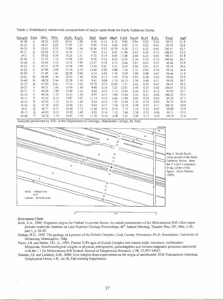
Table 1. Preliminary whole-rock compositions of major units from the Early Gabbroic Series
Sample Unit SiO2 TiO2J9-38 A 48.26 0.25 20.01 1.28J9-35 A 49.47 0.25 17.93 1.32J9-32 B 52.63 0.55 13.84 1.54J9-31 B 52.66 0.75 16.36 1.11J9-2 C 50.02 0.50 16.23 1.31
J9-46 F 51.53 1.12 15.08 1.26J9-24 G 45.65 3.73 15.74 1.99J9-23 G 47.31 4.79 12.98 1.99J9-22 G 47.06 3.05 15.14 2.19J9-29 J 51.48 1.61 22.98 0.92J9-41 M 48.09 1.30 18.93 1.38J9-40 M 48.29 2.64 22.28 1.26J9-37 M 47.03 0.41 17.52 1.62J9-27 P 48.31 1.83 15.56 1.50J9-17 P 49.20 1.80 15.40 1.45io-io P 49.30 1.72 14.53 1.50jo-il p 4743 2.15 15.81 1.67J0-14 P 49.63 1.15 16.14 1.30J9-26 Q 51.70 0.93 14.68 1.21J0-4 Q 48.17 0.17 18.48 1.72
J0-13 Q 49.03 0.12 19.92 1.48J9-48 Y 52.76 1.75 18.81 1.70
!P MiiQ M CaO ! !Qs8.50 0.12 8.75 8.92 2.94 0.25 0.048.80 0.14 9.40 9.05 2.75 0.23 0.03
10.24 0.23 10.70 8.38 2.13 0.22 0.027.42 0.16 8.03 11.08 2.65 0.42 0.138.72 0.15 8.99 11.68 2.46 0.25 0.038.38 0.16 8.24 12.05 2.34 0.33 0.10
13.27 0.18 4.73 9.60 2.87 0.61 0.5713.26 0.21 5.41 9.39 2.68 0.81 0.3114.60 0.20 4.88 7.36 3.13 0.93 0.766.14 0.08 1.76 9.58 3.80 0.98 0.079.20 0.13 7.43 9.74 2.85 0.29 0.038.41 0.09 1.76 10.15 3.78 0.48 0.11
10.79 0.15 10.25 7.71 2.63 0.29 0.079.98 0.16 7.23 12.81 2.40 0.23 0.029.68 0.16 7.15 12.09 2.44 0.37 0.139.97 0.17 7.84 12.60 2.32 0.21 0.06
11.14 0.16 6.46 11.80 2.45 0.29 0.038.63 0.15 7.25 12.94 2.32 0.19 0.028.03 0.17 7.64 12.79 2.58 0.47 0.11
11.46 0.16 8.16 7.12 3.14 0.35 0.079.85 0.14 7.12 7.66 3.38 0.35 0.06
11.30 0.10 4.38 3.07 2.92 2.15 0.22
99.33 61.899.39 62.6
100.51 62.1100.83 63.0100.37 61.8100.64 60.798.96 35.999.14 39.099.32 34.499.44 31.099.40 55.999.26 24.798.47 59.9
100.07 53.299.90 53.7
100.22 55.399.39 47.799.72 56.9
100.32 59.999.00 52.899.11 53.299.19 37.8
Fig. 1. North-Southcross section of the EarlyGabbroic Series. Notethe P-J-Q-P-J sequencein the center of thefigure. (from Nathan,1969).
References Cited:Jerde, E.A., 2000, Magmatic origins for Nathan's Layered Series: An initial reassessment of the Midcontinent Rift's first major
plutonic materials: Institute on Lake Superior Geology Proceedings, 46th Annual Meeting, Thunder Bay, ON, May, v.46,part 1, p. 24-25.
Nathan, H.D., 1969, The geology of a portion of the Duluth Complex, Cook County, Minnesota: Ph.D. dissertation, University ofMinnesota, Minneapolis, i98p.
Paces, J.B. and Miller, J.D., Jr., 1993, Precise U-Pb ages of Duluth Complex and related mafic intrusions, northeasternMinnesota: Geochronological insights to physical, petrogenetic, paleomagnetic and tectono-magmatic processes associatedwith the 1.1 Ga Midcontinent Rift System: Journal of Geophysical Research, v.9 8, 13,997-14013.
Scoates, J.S. and Lindsley, D.H., 2000, New insights from experiments on the origin of anorthosite: EOS Transactions AmericanGeophysical Union, v.81, no.48, Fall meeting Supplement.
37
Analyses performed by XRF in the Department of Geology, Macalester College, St. Paul.
0 I,,,,

GEOPHYSICAL ANSWERS TO GEOLOGIC QUERIES IN THE SUPERIOR PROVINCE OFNORTHERN MINNESOTA
JIRSA, Mark A., and CHANDLER, Va! W.(Minnesota Geological Survey, [email protected], and [email protected])
Geophysical investigations play a vital role in geologic mapping in Minnesota. As an example, we presenthere some highlights from mapping the Archean Superior Province in parts of Minnesota where the bedrockis covered by glacial sediment as thick as one hundred meters. Mapping of the well-exposed Archeanrocks, restricted largely to the Vermilion district of northeastern Minnesota (Fig. 1), was completed in the1960s and 1970s. Although significant, this outcrop mapping suffered from two shortcomings: 1) the areaconstitutes less than 5 percent of the state's bedrock crust; and 2) the Vermilion district may not berepresentative of the remainder of the state's Archean terranes that comprise two-thirds of Minnesota'sfirst crystalline bedrock beneath glacial materials. These shortcomings were recognized in the late-1970sby Dr. Matt Walton, then-director of the Minnesota Geological Survey (MGS). He lobbied the State Legislatureand received funding (from 1979 to 1991) to collect high-resolution, state-wide, aeromagnetic data. Additionalaeromagnetic data were contributed by the U.S. Geological Survey and U.S. Steel Corporation. This wascoupled with efforts to map areas having poorly exposed bedrock, acquire gravity and corresponding rockproperties data, and drill test-borings in locations determined by the new geophysical data and geologicmodels. After two decades, the results include aeromagnetic coverage of the entire state, a grid containingmore than 56,000 gravity stations (averaging 1 station per 2 square kilometers, state-wide), 2,500determinations of density and magnetic susceptibility from nearly every major rock type, and drill coresrepresenting many of Minnesota's Archean rocks. Armed with these data, the MGS has produced variablydetailed geologic maps, and in the process raised important questions about the nature of the Archeancrust. Some of those questions are described below.
Archean rocksMafic to felsic stocks
Figure 1. Simplified geologic map of the Superior Province in Minnesota showing the location of variousmap areas discussed in the text (LLSD—Leech Lake structural discontinuity, GRB—Giants Rangebatholith).
InternationalFalls VERMILION
DISTRICT
9o
COOK- ,-'SIDE LAKE>GRB NIA
HORN
LIJthb2
//
Granitoid batholiths
Schist of sedimentary protolith
0 6OmiI I I
L_0 80km
Gneiss and schist
MAP AREA
(JJ Layered mafic complexes
Metavolcanic and metasedimentary rocks
38

Early thrust nappesMapping in the Cook-Side Lake area (Fig. 1) was directed toward understanding the geological
relationships between well exposed strata of the Vermilion district on the east, and the less well exposedrocks of the Side Lake area on the west. The volcanic sequences in each district are lithologicallysimilar, and form broad anticlines that face stratigraphically toward one another. The intervening area,covering some 600 square kilometers, is marked by scattered exposures composed of turbiditic graywackeand slate of the Lake Vermilion Formation. These strata are complexly deformed, and their interpretationrequired detailed structural and sedimentological analysis. The model that evolved requires that muchof the Lake Vermilion Formation has been exhumed to a level that exposes the bottom of a very largethrust nappe. Geophysical data are consistent with this interpretation, as they show graywacke as arelatively thin, geophysically translucent package overlying a "floor" of denser and variably magneticvolcanic strata.Leech Lake structural discontinuity
The broadly folded volcanic and turbiditic strata of the Lake Vermilion Formation are part of whatis known as the Soudan belt. The Soudan belt is structurally contrasted with the adjacent Newtonbelt to the north; the latter forms a series of fault-bounded, mostly north-facing, homoclinal panels.The Newton belt differs further in containing komatiitic flows and abundant mafic to ultramafic sillsthat are not present in rocks of the Soudan belt. In the well-exposed Vermilion district, the belts aredissected by late faults to such an extent that the relationships between the belts, and even the exactposition of the boundary, are unclear. Extending the belts westward away from the zone of coincidingfaults using a combination of geophysical, outcrop, and drilling data identified a major state-widediscontinuity between the two contrasting structural panels. Although its origin is not well understood,the informally named Leech Lake structural discontinuity (LLSD on Fig. 1) is considered a significantArchean crustal suture.Mud Lake syncline
Because Archean bedrock in the area known as the Virginia horn (Fig. 1) is mantled by magneticiron-formation of Paleoproterozoic age, recent mapping in the area relied almost exclusively on gravitymodeling. The Archean bedrock is marked by a large fold, thought by earlier geologists to be an anticline,having graywacke in the core and volcanic strata on the limbs. The graywacke is complexly folded,and detailed structural analyses of cleavage/bedding relationships produced a contrasting model of anearly-formed, west-facing, upright syncline. The model was tested by a series of gravity profiles thatoutlined a broad synform that is cored by relatively low-density graywacke, and flanked by inward-facing limbs of dense basaltic crust. Gravity modeling indicates that graywacke along the synclineaxis is I to 2 kilometers thick and underlain by dense basaltic rocks.Geophysical boundary at 5 kilometers
Constrained by physical property data, gravity and magnetic model studies of Superior Provincerocks in Minnesota indicate that density and magnetization contrasts associated with the Archeangreenstone-granite belts do not appear to extend to depths much greater than about 5 kilometers. Thisdepth is surprisingly shallow, given the width and near-vertical geometry of most of these belts. Thebelts could be cut off by low-angle thrusting, which would be consistent with the convergent-margin,accretionary models advanced by the Canadian Lithoprobe project. On the other hand, the limiteddepth extent of the greenstone-granite belts could represent enhanced assimilation and mixing of magmaticand supracrustal components at depth. Support for the latter model exists along the southern boundaryof the Giants Range batholith with adjacent supracrustal sequences that are complexly invaded andlocally migmatized by granodiorite. In either interpretation (low-angle thrust or assimilation at depth),gravity and magnetic model studies indicate the observed anomaly signatures associated with SuperiorProvince rocks in Minnesota are largely the result of sources within the uppermost crust, and that relativelylittle anomaly signature is apparently produced by middle or lower crustal rocks.
In summary, aeromagnetic data, supplemented by gravity and rock property data, have had tremendousimpact on mapping Superior Province rocks in Minnesota. These geophysical data provide an essentialframework and continuity that is not typically available from existing drill holes and outcrops. Duringthe last 20 years, much of the Archean bedrock outside of the Vermilion district has been remapped atscales of 1:1,000,000 or greater. This ongoing mapping provides a valuable base for launching mineralexploration programs, and has revolutionized our understanding of early crustal evolution in Minnesota.
39

DISTRIBUTION OF ARSENIC IN WISCONSIN GROUNDWATER
DAVE JOITThSON, Drinking Water & Groundwater Bureau, Wisconsin Department ofNatural Resources, PU Box 7921, Madison, WI 53707-7921,johnsdmmail0.dnr.state.wi.us
Iii the past ten years, with the recognition of elevated arsenic is drinking water supplies, theWisconsin Department of Natural Resources has analyzed over 15,000 individual samples statewide.Ten percent of the statewide samples exceed the 10 ppb proposed Arsenic standard by the USEnvironmental Protection Agency; in some large areas over 25 percent of the samples exceed thislevel. The objectives of the sampling program were to (1) identify the distribution of elevatedarsenic in water supplies, (2) identify concentration ranges and causes for the elevated arsenic, and(3) determine construction guidelines to minimize the problem.
The arsenic appears in many settings, the most common presently recognized being anortheast trending belt in east-central Wisconsin, west of the Fox River. The highest concentrationin Wisconsin, 15,000 ppb, occurs in this belt. Numerous studies (Burkel, 1993; Pelczar, 1996; Simoand others, 1996,1997; and Gotkowitz, 2001) have identified a sulfide-rich horizon recognized nearthe top of the St. Peter sandstone. This appears to be the principal source for As in this area.However, there are some elevated levels west of the western-most subcrop extent of the sandstoneunit.
Other areas of elevated As have been identified. These include relatively shallow domesticwater wells in Silurian dolomite in southeast Wisconsin and in association with the UpperMississippi Valley Zinc-Lead District in southwestern Wisconsin. Elevated concentrations are alsonoted in isolated areas in central and northeastern Wisconsin associated with unique Precambrianunits.
Township-based surveys of private wells in east central Wisconsin are continuing and maypermit greater delineation of the As problem and possible solutions.
Burkel, R.S., 1993, Arsenic as a Naturally Elevated Parameter in Water Wells in Winnebago andOutagamie Counties, Wisconsin: unpub. MS thesis, University of Wisconsin -Green Bay, 111 p.
Pelczar, J.S., 1996, Groundwater Chemistry of Wells Existing Natural Arsenic Contamination inEast-central Wisconsin: unpub. MS thesis, University of Wisconsin - Green Bay, 206 p.
Simo, J.A., Freiberg, P.G., and Freiberg, KS., 1996, Geologic Constraints on Arsenic inGroundwater with Applications to Groundwater Modeling: Wisconsin Water Resources Center GRR96-01, 57 p.
Simo, J.A., Freiberg, P.G., and Schreiber, M.E., 1997, Stratigraphic and Geochemical Controls on theMobilization and Transport of Naturally Occurring Arsenic in Groundwater: Implications for WaterSupply Protection in Northeastern Wisconsin: Wisconsin Water Resources Center GRR 97-05, 56 p.
Gotkowitz, M.B., Scbrieber, M.E., and Simo, J.A., 2001, Contrasts in the geologic andhydrochemical Occurrences of Arsenic contamination of Groundwater in Eastern Wisconsin:thstitute on Lake Superior Geology, this meeting.
40

FLUID INCLUSION EVIDENCE FOR A ROLE FOR HYDROTHERMALACTIVITY IN THE ROBY ZONE, LAC DES ILES MINE, NORTHWESTERNONTARIOJOHNSON, J.R. and KISSIN, S.A., Department of Geology, Lakehead University, ThunderBay, ON, P7B 5E 1, [email protected]
The Roby Zone of the Lac des lies Pd-Pt-Ni-Cu-Au mine, located 90 km north-northwest ofThunder Bay, Ontario, was the initial locus of mining activity in the deposit. A strikingaspect of the deposit in the early stages of mining was the coincidence of the ore zone with anenvelope of taicose hydrothermal alteration (Michaud, 1998). Based on evidence ofhydrothermal activity in off-set and deep, copper-rich deposits at Sudbury (Molnar et al.,1997) and observations of felsic veins and pods in the Roby Zone, an investigation of fluidinclusions was undertaken.
From a suite of samples collected during pre- and early-mining stages at the RobyZone by Michaud (1998), hand specimen were selected. The hand samples used in the studywere selected based on the presence and abundance of transparent minerals.
From three hand samples (Lac-3 18, Lac-304 and Lac-46) taken from the heterolithicgabbro located in the middle of the Roby Zone, a number of doubly polished sections 100tim-thick were prepared. Sample Lac-3 18 is composed of pegmatitic gabbro that containminor veins of plagioclase and epidote. Sample Lac-304 consists of a quartz vein that isemplaced within a medium-grained gabbro. The last sample used, Lac-46, is a medium-grained gabbro crosscut by a felsic vein network.
Four distinct types of fluid inclusions were observed occurring in plagioclase andquartz:
Type I - Single-phase liquid inclusions. These were extremely numerous inquartz but less common in plagioclase.Type II- Two-phase inclusions (liquid + vapour). The most numerous type ofinclusion that was found in plagioclase. The majority had a vapour content of10-20% by volume.Type III - Polyphase inclusions (liquid + vapour + one or more solid phases).These were fairly abundant but of a small size, occurring only only inplagioclase. Numerous inclusions contained a single crystal, but only a fewwere found to contain more than one solid.Type IV - CO2-rich polyphase inclusions. These were found only inplagioclase, containg two solids, two liquids and vapour.
The fluid inclusion studies revealed the following results:
Type II and Type III inclusions - All but one inclusion homogenized to vapourin the range of 540.1-352.4°C, but the majority were in the range 460-420°C.Eutectic temperatures generally clustered about -52°C or -49.8°C, the eutectics
41

for NaC1-CaC12-H20 and CaCl2-H20, respectively. Some lower eutectictemperatures observed may be the result of the small size of the inclusions anddifficulty in detecting the first melting. Some eutectic temperatures were near-21.2°C, the NaCl-H20 eutectic temperature. These may be attributed to lowerconcentrations of CaC12, such that its effects on melting behaviour weredifficult to observe. Most inclusions in this group had final meltingtemperature of about -20°C, indicating moderate to high salinity.
Type IV inclusion - Only one inclusion containing liquid CO2 and twodaughter crystals was observed. The eutectic temperature was -54.2°C with afinal melting temperature of -15.5°C, consistent with data from Type II and IIinclusions. Liquid CO2 homogenized to vapour at 26.8°C, and the remainingvapour homogenized to liquid at 160.8°C. However, the daughter crystalsmelted at 230°C and >412°C, the decrepetation temperature.
Type I - Liquid only inclusions exhibited eutectic temperatures of--34°C andfinal melting temperatures of-15°C. These inclusions, although saline, wereclearly formed at low temperature.
The study has shown that high-temperature saline fluids are intimately associated withthe ore zone of the Roby Zone. It is suggested that the present distribution of the ore is theresult of hydrothermal activity associated with these fluids, possible of late magmatic origin.Similarity to fluids active in the Sudbury Igneous Complex is striking.
Michaud, M.J., 1998. The Geology, Petrology, Geochemistry and Platinum-Group Element-Gold-Copper-Nickel Ore Assemblage of the Roby Zone, Lac des Iles Mafic-UltramaficComples, Northwestern Ontario. M.Sc. thesis, Lakehead University, Thunder Bay, Ontario.
Molnar, F., Watkinson, D.H., Jones, P.C. and Gatter, I., 1997. Fluid inclusion Evidence forHydrothermal Enrichment of Magmatic Ore at the Contact Zone of the Ni-Cu-Platinum-Group Element 4b Deposit, Lindsley Mine, Sudbury, Canada. Economic Geology, vol. 92,pp. 674-685.
42

HYDROGEOCHEMICAL MODELING OF ARSENIC IN MINNESOTA GROUNDWAT1R
KANTVTSKY, Roman, Minnesota Geological Survey, 2642 University Avenue, St. Paul, MN55114, [email protected]
Concentrations of dissolved arsenic in Minnesota ground water commonly exceed 3pJL(micrograms per liter) and are as much as 157 piL. The highest regional concentration of arsenic inground water (0.06—91 WL, mean 6 iJL) is documented in the western part of the state where theaquifers are buried bodies of sand, gravel, and silty sand that form discontinuous lenses beneathlake deposits and within till. Because of this, the hydrogeochemical modeling was performed forground water systems in this part of the state.
A surface complexation two-layer sorption model was used to assess the mechanismscontrolling arsenic distribution in the Quaternary buried artesian aquifer and Cretaceous aquifersystems. The release of sorbed arsenic from iron hydroxides into ground water was estimated bythis model. The test data consisted of concentrations of total arsenic and iron in solution; this wasderived from the arsenic and iron concentrations in the geological materials. The result of thismodel is the distribution of arsenic—either adsorbed to the surface of iron hydroxides, or into theaqueous phase.
These results suggest that mobility of arsenic is promoted by the onset of suboxicconditions in aquifer systems where iron hydroxides have sorbed arsenic. The reduction of ferricoxides and hydroxides, together with the reduction of As(V) to the less-strongly adsorbed andmore mobile As(III), can release adsorbed arsenic into ground water. This reduction may bedriven by microbial degradation of natural organic matter in aquifer systems. The source of thearsenic in the Quaternary buried artesian system is presumed to be iron oxides and iron hydroxidesthat have sorbed arsenic, and form amorphous coatings on mineral grains within the silty-clayeytill. Despite the fact that the arsenic concentrations in the ground water and the geological materialsused for the modeling were far apart, the modeling illustrates that the process is probably genericand not limited by geography.
Based on the sorption model and the classification of aqueous environments, the workingmodel that explains the mech anisms controlling distribution of arsenic in ground water can beapplied to five hydrogeochemical systems in Minnesota: the Quatemary buried artesian aquifersystem, the Quaternary water-table aquifer system, the Cretaceous aquifer system, the Paleozoic-Mesoproterozoic artesian basin aquifer system, and the Precambrian crystalline rock aquifersystem. The thick, silty-clayey, glacial and lacustrine sediments that cover the aquifers of theQuatemary buried artesian aquifer system in west-central Minnesota serve as a geochemicaltransition zone associated with the transformation from oxic to suboxic conditions. In areas wherethe tifi is more sandy, suboxic conditions may not exist. Variability in arsenic concentrations inwater of the Quaternary buried artesian aquifer system can thus be explained by changes ingeochemical conditions, the variability of the arsenic content in the sediments, or by variability indistribution of chemical reductants (e.g. buried organic matter). Waters within otherhydrogeochemical systems typically have low concentrations of arsenic, possibly because they areassociated with oxic conditions. High arsenic concentrations associated with sulfide mineralizationor iron-formation may be present locally within any system, but are not a regional feature of any ofthese hydrogeochemical systems.
Reference:
Kanivetsky, R., 2000, Arsenic in Minnesota ground water: hydrogeochemical modeling of theQuaternary buried artesian aquifer and Cretaceous aquifer systems: Minnesota Geological SurveyReport of Investigation 55, 23 p.
43
ROCK MAGNETIC STUDIES OF PHYLLITIC ZONES FROM THE BARABOOSYNCLINE, WISCONSIN.
KELLY*, COLLEEN, AND KEAN, WILLIAM F., Department of Geosciences,University of Wisconsin —Milwaukee, P.O. Box 413, Milwaukee, WI [email protected]. (* student)
Preliminary paleomagnetic results based on limited sampling from a variety of rock types,suggested that the magnetism of the metamorphic rocks associated with the BarabooSyncline was pre-folding (Kean and Mercer,1986). The detailed work by Mercer (1984)based on data from two quartzite sites on the southern limb and one site on the northern limbshows the magnetism is carried by hematite, and is prefolding. The unfolded magneticdirection is Dec=201°, Inc.66.4°, Alpha 95=10.7°, which gives a paleopole at 257°E,4.67°N. This is consistent with 1.75Ga. paleopole positions for North American.
However, the sites with phyllites were notably inconclusive (Mercer, 1984). Possible causes
are; incomplete structural information, synfolding magnetization that was not recorded by thequartzite, or anisotropy of magnetization caused during the folding. Nonetheless magneticresults from these strata could provide important clues about the actual age of folding of thesyncline. The phyllites result from metamorphism of clay rich layers within the originalsandstone sequence, which could also contain hematite, magnetite or maghemite. It is likelythat the magnetic mineralogy, and/or the magnetic direction in these layers will changeduring metamorphism and folding, and therefore provide information on the deformation
history.
A suite of oriented hand samples, collected from phyllitic zones on both sides of the BarabooSyncline, were subjected to a variety of magnetic measurements to determine the magneticmineralogy and remanent directions. The measurements included stepwise alternating field(AF) and thermal demagnetization to either 1 OOmT or 750° C respectively, magneticsusceptibility, saturation isothermal remanent magnetization (SIRM), and hysteresisproperties. A.F. demagnetization was mostly ineffective. However, the thermaldemagnetization results show that the majority of samples have a single magnetic directionthat reduced to zero intensity between 650-750° C. The SIRM plots never reach saturation by300mT, and the coercivity of remanence (Hcr) values derived from the hysteresis ioops are inthe range of 140-180 mT. These results are indicative of hematite with an effective grain size
of 15-20 tm, that probably developed during metamorphism. However, additional studies
are required to exclude the possibility that the differences in the magnetic directions for thesesites are not due to local structural conditions, or anisotropy of remanent magnetization.
References:Mercer, D.,1984, Paleomagnetism of the Baraboo Quartzite, Unpublished MS thesis, UW-
Milwaukee, 294 pp.Kean, W.F. and Mercer, D., 1986, Preliminary Paleomagnetic Study of the BarabooQuartzite, Wisconsin, Geoscience Wisconsin, Vol. 10, p 46-53.
44

HEALTH SURVEILLANCE IN A COMMUNITY AFFECTED BY ARSENIC-CONTAMINATED WATER
Lynda Knobeloch and Charles Warzecha, Wisconsin Department of Health and Family ServicesShelli Nelson, University of Wisconsin-Madison, Environmental Toxicology Center
Many private drinking water wells in Wisconsin's Fox River Valley contain naturally occurringarsenic at levels of health concern (Riewe et al., 2000). In 1993, the Department of Health andFamily Services surveyed water use and health status among families living in the affectedregion. Data from this initiative indicated that residents whose daily arsenic intakes exceeded 50
were approximately three times more likely to report skin cancer than residents with lowerarsenic intakes (Haupert et al, 1996). The Department is currently re-evaluating arsenic exposureand health status in this region. Three factors make this re-evaluation timely. In January, theU.S. EPA lowered the safe drinking water standard for arsenic from 50 ug/L to 10 ugIL,increasing the number of wells that will be deemed "unsafe." Since the previous study, thenumber of families that use private wells in this region has increased dramatically. In addition,repeated sampling of several wells in this region seems to indicate that arsenic concentrations areincreasing over time, possibly due to regional drawdown of the aquifer. The current study coversa much broader geographic region than the 1993 study. Each township within Outagamie andWinnebago Counties has been encouraged to participate. To date, nearly 2000 families havesubmitted well water samples for arsenic analysis and completed a 4-page health questionnaire.This larger study population, combined with a more extensive list of health outcomes, isexpected to provide us with a better understanding of arsenic exposure and its impact on thehealth of families that consume water from private wells in these counties.
References:Riewe T, Weissbach A, Heinen L, and R Stoll, 2000. Naturally occurring arsenic in well waterin Wisconsin. Water Well J; (June 2000): 24-31.
Haupert TA, Wiersma JH, and JM Goldring, 1996. Health effects of ingesting arsenic-contaminated groundwater. Wisc Med J; 95(2):100-104.
45

HYDROGEOLOGIC SETTING OF ELEVATED ARSENIC IN SOUTHEASTERN MICHIGANKOLKER, Allan, and CANNON, W. F., U.S. Geological Survey, Reston, VA, 20192,HAACK, S. K., and WESTJOHN, D. B., U.S. Geological Survey, Lansing, Ml, 48911, andWOODRUFF, L. G., U.S. Geological Survey, Saint Paul, MN 55112.
High levels of arsenic, up to nearly 40 times the EPA standard of 10 tg/L, are present insoutheastern Michigan, primarily in private supply wells. To investigate the problem, the USGS,in collaboration with the University of Michigan, sampled more than 100 wells, including public,private and monitoring wells, and examined aquifer materials in the region for possible sourcesof arsenic. The study area includes nearly all of Genesee, Huron, Lapeer, Livingston, Oakland,Sanilac, Shiawassee, Tuscola, and Washtenaw counties, which have a combined population ofmore than 2 million. Of the wells sampled by the USGS, more than 50% exceed the currentEPA drinking water standard [1,2]. Most of the affected wells are completed in the MarshallSandstone (Mississippian), the principal bedrock aquifer in the region, but in some cases, waterin overlying glacial aquifers, or in the Saginaw (Pennsylvanian) aquifer is also affected.Problem wells are concentrated in the eastern and southeastern parts of the MarshallSandstone subcrop belt, where Marshall Sandstone is in direct hydrologic contact withpermeable Pleistocene glacial deposits [3].
To investigate the possible relation between the composition of aquifer materials and thearsenic content of well water, test wells were drilled by the USGS in Huron County (H-i 5D) andLapeer County (LP-1), in areas known to contain wells with high arsenic contents. Both of theUSGS wells show a gradual decrease in total arsenic of well water with depth, but redoxconditions (Eh = 29 to 68 mV; [1]) and the fraction of As III (88 — 100% of total arsenic),measured for H-15D, are essentially uniform with depth (Figure). There is no distinct correlationbetween arsenic contents of aquifer materials, sampled in 4.5 ft. (1.37 m) intervals (0 to —300ppm), and waters, sampled largely in 50-ft. (15.7 m) intervals (Figure). Likewise, there is nocorrelation between As concentration and total Fe or SO4 contents of waters in the region, evenfor samples having the highest (>50 p.g/L) As contents. These findings suggest that in-situpyrite oxidation in the Marshall aquifer is very limited.
In the Marshall Sandstone and in portions of the overlying Michigan Formation, pyrite islocally present as a cement whose texture indicates growth that has displaced framework sandgrains. This pyrite locally contains highly arsenic-enriched domains (up to 8.5 wt. %) occurringas overgrowths on pyrite framboids having much lower arsenic contents, that are in turnincorporated into pyrite having low arsenic contents [4,5]. Well cuttings containing arsenic-richpyrite have arsenic contents as high as 1020 ppm. Investigation of till samples containing ironoxy-hydroxides, probably derived from weathering of arsenian pyrite, shows arsenic contents upto about 0.7 weight percent. This indicates that a portion of the arsenic is retained during theweathering/oxidation process, or that arsenic is concentrated on oxide surfaces by adsorption ofaqueous arsenic.
Because there are multiple sources of arsenic in glacial and bedrock aquifers that are inhydrologic continuity, no single process may explain the overall distribution of arsenic insoutheastern Michigan wells. Reduction of iron-oxyhydroxides in glacial aquifers by exposure tosuboxic ground water, is one possible source. In-situ pyrite oxidation, while limited, may locallybe enhanced by high concentrations of bicarbonate [6]. Because of the extreme arseniccontents of some Marshall Sandstone pyrite, small amounts of in-situ oxidation could result incontamination of bedrock aquifers. Likewise, we cannot rule out sporadic paleo-oxidation ofpyrite in the bedrock aquifer, resulting from lower water table levels that existed following thelast glaciation. All of these processes have likely contributed to the widespread but sporadicnature of arsenic enrichment in southeastern Michigan ground water.
46

Compilation ofanalytical results forarsenic in USGS testcores H-15D (A), andLP-1 (C) and waters incorresponding packedintervals (B and D).Data represent bedrockintervals only, with theexception of glacial driftrecovered from LP-i.Brackets on water dataindicate size of packedintervals represented.Results for arsenicspeciation in H-i 5Dwaters are from M.-J.Kim [21.
Sandstone!Siltstone
Mudstone
[1] Haack, S. K., and Trecanni, S. L., 2000, Arsenic concentration and selected geochemical characteristics of
ground water and aquifer materials in southeastern Michigan: U.S. Geological Survey Water Resources
Investigations Report 00-4171, 38 p.
[2] Kim., M.-J., 1999, Arsenic dissolution and speciation in groundwater of southeast Michigan: Ph.D. dissertation,
University of Michigan, Ann Arbor, Ml, 201 p.
[3] Westjohn, 0. B., and Weaver, T. L., 1998, HydrogeologiC framework of the Michigan Basin Regional Aquifer
System: U.S. Geological Survey Professional Paper 1418, 47 p.
[4] Kolker, Allan, Cannon, W. F., Westjohn, 0. B., Woodruff, L. G., 1998, Arsenic-rich pyrite in the Mississippian
Marshall Sandstone: Source of anomalous arsenic in southeastern Michigan ground water: Geological Society
of America, Abstracts with Programs, v. 30, no. 7, p. A-59.
[5] Kolker, Allan, Cannon, W. F., Woodruff, L. G., Westjohn, D. B., Haack, S. K., and Kim, M.-J., 1999, Arsenic in
southeastern Michigan ground water: Results of USGS test drilling: EOS, American Geophysical Union
Transactions, v.80, no.17, p. S146- S147.
[6] Kim, M.-J., Nriagu, Jerome, and Haack, S. K., 2000, Carbonate ions and arsenic dissolution by ground water:
Environmental Science and Technology, v. 34, p. 3094-3100.
E
aC
0
10
20
30
40
6070
80
90
100
110
120
As (ppm)
Shale
As (ppb)
References
Carbonate
47

POTENTIAL FOR COPPER MINERALIZATION IN THE ANIMIKIE GROUP, MINNESOTALARSON, Phillip C., Department of Geological Sciences, University of Minnesota, Duluth, MN 55812,[email protected]
Numerous lines of evidence have recently been identified suggesting the potential occurrence of Keewenawan-style native copper or White Pine-style sediment-hosted copper mineralization in Animikie Group sediments innortheastern Minnesota.
Native copper has been reported in quartz veins in the Wanless Mine near Buhi (Gruner, 1946). Copper-stained rocks have been observed in the Butler Taconite mine (D. Ridgeway, pers. comm.). Hydrothermally altereddiabase dikes in the National Steel Pellet Company (NPSC) Mine have elevated copper values (up to 950 ppm)associated with a chlorite-quartz alteration assemblage (Larson et a!., 1999). In addition, diagenetic pyrite from theNSPC mine frequently displays a secondary coating of chalcopyrite on bedding and fracture surfaces. Finds of floatnative copper in glacial drift have occasionally been reported in the Nashwauk-Keewatin area of the Mesabi Range(L. Mattson, pers. comm.). It is improbable that this float copper is derived from the Lake Superior basin, assurficial drift on the Mesabi has either a northwest or northeast provenance; this strongly suggests a localprovenance. These occurrences suggest the northern flank of the Animikie Basin has hosted a regional-scalemineralizing event by an oxidized cupriferous fluid.
The timing of copper mineralization is constrained by cross-cutting relationships. A series of diabase dikesintrude iron formation in the NSPC mine area; these dikes are tentatively dated at —1 100 Ma. Overprinting ofalteration on well-developed cooling structures and post-emplacement shears in the dikes suggests that the coppermineralizing event significantly post-dated dike emplacement — similar to native copper mineralization on theKeewenaw peninsula. In contrast, in the South Stevenson Mine a diabase dike intruded the natural iron-ore body,indicating dike emplacement post-dates natural iron-ore formation. These relationships demonstrate that the naturaliron-ore forming hydrothermal event is distinct from, and preceded the copper mineralizing event.
Morey (1999) has presented a model for formation of natural iron ore deposits on the Mesabi by alterationof Biwabik iron-formation by a hydrothermal fluid generated deep in the Animikie basin. A topographically-drivenregional hydraulic flow system was induced by recharge in a highland area bounding the southern end of the basin.Fluids evolved deep in the basin were driven through relatively permeable strata at the base of the Animikie Group(Pokegama Quartzite). These fluids leaked upward along fractures through the overlying iron-formation toward themargins of the basin.
Concentration of iron oxides in natural iron-ore deposits is chiefly a function of silica removal fromunaltered iron-formation. Evidence suggests that this process extended down into the underlying PokegamaQuartzite as well. Holway (1956) reported that at the Auburn Mine, quartzite underlying the natural iron-ore wascomposed of friable sand from which the silica cement had been leached. In most exposures, the PokegamaQuartzite is a well-cemented low permeability rock. However, local desilicification associated with natural iron-oreformation has enhanced permeability along numerous fault- and fracture-hosted fluid pathways.
During formation of the Midcontinent Rift System, rift-filling volcanics, intrusives, and sedimentstruncated the southern margin of the Animikie basin. The base of the Animikie Group is thus presumably in contactwith volcanic rocks in the deeper portions of the rift — the likely source of oxidized cupriferous brines associatedwith Keewenawan native copper mineralization. These same fluids may have been driven from the western flank ofthe rift into the basal portion of the Animikie Group (Fig. 1). Fluid flow would have been focused through the basalclastic units, and in particular along the preexisting desilicified faults and fractures. Overlying iron-formation andshale units would have served as effective aquitards.
Two scenarios for concentration of significant copper mineralization by cupriferous brines dischargingalong the northern margin of the basin present themselves (Fig. 2). High-porosity, high-permeability desilicifiedclastic sediments within the Pokegama Quartzite may be the host for native copper mineralization similar to thatobserved in brecciated flow-tops and conglomerate beds on the Keewenaw Peninsula. Interaction of the brines withthe iron-sulfide-rich base of the Virginia Formation may have produced stratiform copper sulfide mineralizationsimilar to that observed at the White Pine and Presque Isle deposits.
48

References
Figure 1. Schematic cross-section of post-Midcontinent Rift flow system through theAnimikie Basin.
Figure 2. Schematic cross-section of copper mineralization, showing relationshipbetween faults/fractures, desilicification, and Animikie Group sediments.
Gruner, J.W., 1946, Mineralogy and Geology of the Mesabi Range: Office of the Commissioner of the Iron Range
Resources and Rehabilitation, St. Paul, 127 p.Hoiway, W., 1956, Auburn Mine, in Schwartz, G.M., ed., Geol. Soc. America Annual Meeting Field Trip 1
Guidebook, p.160-167.Larson, P. C., Hanttula, J. E. and Price, J. 5., 1999, Proterozoic mafic dikes, western Mesabi Range, Minnesota.
GSA Abstracts with Programs, Vol. 31, No. 7: 106.Morey, G. B., 1999, High-grade iron ore deposits of the Mesabi Range, Minnesota — product of a continental-scale
Proterozoic ground-water flow system. Economic Geology 94: 133-142.
Midconfinent RiftMesabi RangeAnimikie Basin
OronfoIBaieIdSEGroup Sec mentsJNW
k\ White Pine-Style\ Copper Sulfide \Tirginia Formation
49

CONTRIBUTIONS TO THE CULTURAL GEOGRAPHY OF THE WEST MESABI RANGE,NORTHERN MINNESOTA
LIVELY, Richard and MOREY, G. B.(Minnesota Geological Survey, [email protected] and [email protected])
The Mesabi Iron Range in northern Minnesota has produced more than 4 billion tons of iron ore andtaconite from more than 500 mines since ore was first shipped from that area in 1892. Mining, confined toan east-northeast trending strip of land some 100 miles long and 4 miles wide, has greatly modified boththe original landscapes and associated cultural features. In this discussion, we assess some of thosechanges utilizing modern data and topographic maps prepared during the summer of 1899 and 1900 byE.C. Bebb and his assistants D.L. Fairchild and Louis B. Weed, all topographers with the U.S. GeologicalSurvey. The original data were compiled at a scale of 1:16,000 with a contour interval of 20 feet, andultimately were published at a scale of 1:50,000 in 1903 (Leith, 1903). The original field maps wereobtained from the Cuyler Adams estate in the early 1 980s and were subsequently digitized by Emily Bauerof the Minnesota Geological Survey to produce a pre-mining topographic rendition of the western half ofthe Mesabi range. The digitized maps were prepared as part of a larger study of the hydrologic character ofthe western Mesabi range sponsored by the Legislative Commission on Minnesota Resources (LCMR).
We compare here the 1899-1900 data with topographic data obtained in 1999 by the MinnesotaDepartment of Natural Resources as part of the Mesabi Elevation Project (DNR, 1999). As one wouldexpect, open-pit mining has considerably changed the topographic expression along the range, mainly byincreasing the relative abundance and depth of topographically low areas and redistributing topographicallyhigh areas. In general, the overall spread in elevation has increased by over 100 feet due to excavation,while over the same period the maximum elevations on the range have not changed substantially. Whencomparing data from the 1999 high-resolution digital surface with data from the 1899-1900 survey inundisturbed areas, the resulting correlations are virtually identical. This implies a high degree of accuracyamong the early topographers mapping the Mesabi range.
In 1899-1900, the western half of the range contained 11 mines and 17 mine dumps totaling about0.7 square miles, or about 0.3 percent of the 230 square miles originally mapped. In 1986, mining activityaccounted for about 140 square miles of pits and dumps, or about 60 percent of the study area. Miningalso significantly affected drainage patterns along the range. In 1899-1900, mapped streams totaled over400 miles in length, whereas only about 220 miles could be found compiled from topographic mapsbetween 1970 and 1990, a reduction of about 45 percent. Much of that loss involved the removal ofheadwaters for many southward flowing streams along the south side of the Laurentian drainage divide.
The transportation features mapped on the range in 1899-1900 were primarily limited to about 170miles of roads or trails and about 125 miles of railroad track. Most of these extended along the strike of therange, with relatively little development crossing the range. By 1990, railroad mileage had doubled to about250 miles and road length had increased to over 1000 miles. In addition to the increased transportationnetwork, mining created and destroyed many towns as it progressed. For example, the entire town ofHibbing was moved several miles after a rich deposit was discovered under its streets.
The Leith (1903) report also included a geologic map that was designed to aid exploration bydelineating the boundaries of the Biwabik Iron Formation. That map, compiled during the spring of 1900and the summers of 1900 and 1901, relied heavily on the support and geologic information, especially testpit and drill hole data, provided by J.U. Sebenius of the Lake Superior Consolidated Iron Mines (nowowned by the U.S. Steel Corporation). Although the geologic data base was limited to relatively few,sparsely distributed data points, the resulting geologic map read very much as it does today, even withmore complete data now available. The only significant difference involves a better understanding of faultsand related structures which became apparent as extensive test drilling and mining progressed.
References Cited:
Leith, C.K., 1903, The Mesabi iron-bearing district of Minnesota: United States Geological SurveyMonographs, v. 43, 316 p., 1 plate.
Minnesota Department of Natural Resources, 1999, Mesabi Elevation Project: St. Paul, Minnesota.
50

PRECAMBRIAN GEOLOGY OF S. WISCONSIN: A PANORAMA FROM THE BARABOO RANGEMEDARIS, L.G., Jr., Dept. of Geology & Geophysics, Univ. of Wisconsin-Madison,
1215 W. Dayton Street, Madison, WI, 53706, medarisgeology.wisc.edu
Red, supermature quartzites, most notably the Baraboo, Barron, and Sioux Quartzites, have long beenrecognized as a distinctive Proterbzoic feature in the southern Lake Superior region, signifyingdepositionon a stable craton under conditions of intense chemical weathering in the presence ofsignificant free atmospheric oxygen (Dalziel & Dott, 1970; Ojakangas & Weber, 1984; Southwick et al.,1986). The quartzites were inferred to be post-1750 Ma in age, to have been folded and metamorphosedat —4630 Ma, and locally intruded by granitic rocks at —1450 Ma. The term, Baraboo interval, wasintroduced by Dott (1983) for this succession of sedimentation, deformation, metamorphism, andintrusion in the time span of 1750 to 1450 Ma. In the last six years investigators at Wisconsin and DanHolm at Ball State and coworkers have taken a renewed interest in the Baraboo interval, and their resultssubstantiate the original concept and framework of the Baraboo interval and provide a more detailedunderstanding of the disparate geological processes that shaped the southern Lake Superior region inmid-Proterozoic time.
Igneous Basement of the Baraboo Range The Baraboo Quartzite is underlain by diorite, granite,and rhyolitic lavas and pyroclastic rocks (Dalziel and Doff, 1970). U-Pb zircon ages of the BaxterHollow granite and rhyolite are indistinguishable, and taken together, yield an age of 1749±12 Ma (VanWyck, 1995). Chronologically and petrologically, the Baraboo basement is correlative with thesubalkalic granite and rhyolite suite of the Fox River Valley (Smith, 1978; Anderson et a!., 1980).Igneous textures are well preserved in all units of the Baraboo basement, although igneous minerals arepartly to completely replaced by a variety of greenschist facies minerals. Typically, biotite is replaced bychlorite, plagioclase is transformed to albite and fine-grained epidote (saussurite), and intermediate alkalifeldspar is recrystallized to a fine-grained mixture of near end-member microcline and albite.
Hornblende in diorite is partly replaced by chlorite and intergrown actinolite and cummingtonite.Paleosols beneath the Quartzites Mature paleosols have been recognized beneath the Sioux,
Baraboo, and Barron quartzites (Southwick & Mosler, 1984; Medaris et al., 1997; Medaris, 2000).Among these paleosols, the Barron represents the best standard for comparison, because it has not beenaffected by later hydrothermal alteration, as have the other two. The Barron paleosol is a saprolite,derived from Penokean metatonalite and consisting of quartz, kaolinite, hematite, traces of sericite, andcrandallite-florencite. During weathering of the metatonalite protolith, A12O3, TiO2 and Zr remained
immobile, Na20, CaO, MgO, and MnO were effectively removed, Ba, Sr, K2O, and Rb were substantiallyreduced, and SiO2 decreased by 10%. The extreme chemical maturity of the Barron saprolite is reflected
in a high value, 95.7, for its Chemical Index of Alteration.The Baraboo Quartzite is underlain by saprolite, which varies in thickness from 30 to 50 feet and was
derived from granite and rhyolite. Chemical changes in the Baraboo saprolite relative to protolith are
similar to those in the Barron, except for subsequent hydrothermal addition of K20 and Rb.Common features of the Barron, Baraboo, and Sioux paleosols are the absence of feldspar and a high
degree of mineralogical and chemical maturity, similar to present-day weathering profiles in warm,
humid climates, where intense chemical leaching is characteristic. Such a climate and a stable tectonicsetting were essential for generating the supermature features of the Baraboo interval quartzites.
Depositional Age and Composition of Baraboo Interval Sedimentary Rocks A post-Pen okeandepositional age for the Baraboo interval quartzites was long recognized, and recent analyses of detrital
zircon grains in the Baraboo, Barron, Flambeau, McCaslin, and Sioux quartzites have yielded numerous
U-Pb ages from 1782 to 1712 Ma (Van Wyck, 1995; Doff et a!., 1997; Holm Ct al, 1998), demonstrating
that the quartzites were deposited no earlier than —1710 Ma. The chemical maturity of the Baraboo
51

interval sediments was previously inferred from the near absence of detrital feldspar, the abundance ofpyrophyllite or kaolinite, and the predominance of zircon, magnetite, rutile, and apatite among heavyminerals. Recent analyses of Barron, Baraboo, and Sioux siltstone, pelite, and their metamorphosedequivalents, yield compositions consisting essentially of Si02, Al203, Fe203, hO2, and H20, with aChemical Index of Alteration ranging from 96.8 to 98.6. The extreme chemical maturity of the Baraboointerval sediments reflects a source region that experienced extensive chemical leaching and produceddetritus consisting largely of quartz, kaolinite, and hematite.
1630 Ma Folding and Metamorphism There was widespread Rb-Sr isotopic resetting at 1635±33Ma in Fox River Valley granite and rhyolite, Baxter Hollow granite, and Baraboo rhyolite (Dott &Dalziel, 1972; Van Schmus et al., 1975; X = 1.42*1011 yr'), and it was suggested that such isotopicresetting was coincident with folding of the quartzites, which might represent an eastern expression ofthe Mazatzal deformation in the southwestern U.S. (Dott, 1983; Van Schmus et al., 1993). The extent offoreland deformation is marked by a 1630 Ma tectonic and thermal front in northern Wisconsin, whichwas located on the basis of 40ArP9Ar cooling ages of mica and hornblende in basement rocks and thedistribution of folding in quartzites (Holm et al., 1998; Romano et al., 2000).
The Barron Quartzite is unfolded and unmetamorphosed, consisting of quartz, kaolinite, andhematite. In contrast, the Baraboo Quartzite and underlying basement have been folded andrecrystallized under low grade conditions (Medaris et al., 1998). The coexistence of quartz andpyrophyllite in the metasedimentary rocks requires a temperature between 285°C and 360°C, at 1 kbarand unit activity of H20.
Post-i 630 Ma HydrothermalActivitv Muscovite grains from sub-Baraboo metasaprolite and frommuscovite-pyrophyllite-diaspore veins near the base of the Baraboo quartzite yield discordant 39Arrelease spectra, with well-defined plateaux ages at 1456±11 and 1467±11 Ma, respectively (Naymark etal., 2001a). An apparent whole-rock Rb-Sr isochron age for saprolite and pedogene is 1336±75 Ma.These data provide the first substantial evidence for a Wolf River-age imprint on the Baraboo Range, dueto the effects of hydrothermal fluids that probably were driven along the sub-Baraboo nonconformity byheat from regionally extensive Wolf River magmatism.
Muscovite grains from two samples of Sioux pipestone, which contain the assemblage muscovite-pyrophyllite-diaspore, also yield discordant 39Ar release spectra, but with significantly younger plateauxages of 1370±10 and 1268±11 Ma (Naymark et al., 2001b). The geological significance of such ages isunclear at present, and the —100 m.y. difference in ages of the two samples, which occur at the samestratigraphic level, deserves further investigation. Nevertheless, these recent 40ArP9Ar results reveal theexistence of important, and possibly widespread, post-1630 Ma hydrothermal activity in the southernLake Superior region.ReferencesAnderson, J.L. et al. (1980) Contrib. Mineral. Petrol., v. 74, 3 11-328; Dalziel I.W.D. & Dott R.H., Jr. (1970)Wis. Geol. Nat. History Survey, Inf. Circ. 14, 164 pp; Dott, RH. Jr. (1983) Geol. Soc. Amer. Memoir 160,129-141; Dott, R.H., Jr. & Daiziel, I.W.D. (1972) Jour. Geol., v. 80, 552-568; Dott, R.H., Jr. et al. (1997) GeolSoc. Amer. Abstr. with Progr., v. 29, No. 4, 13; HoIm, D. et at. (1998) Geology, v. 26, 907-910; Medaris, L.G. Jr.et al. (1997) 43rd Inst. Lake Superior Geol., 39-40; Medaris, L.G., Jr. et al. (1998) 44th Inst. Lake Superior Geol.,89-90; Medaris, L.G., Jr. (2000) 46th Inst. Lake Superior Geol., 37-38; Naymark, A. et at. (2001a) Geol. Soc.Amer. Abstr. with Progr., v. 33, No. 4, in press; Naymark. A. et al. (2001b) 47th Inst. Lake Superior Geol., in press;Ojakangas, R.W. & Weber, R.W. (1984) Minn. Geol. Surv., Rept. mv. 32, 1-15; Romano, D. et at. (2000)Precambr. Res., v. 104, 25-46; Smith, E.I. (1978) Geol. Soc. Amer. Bull., v. 89, 875-890; Southwick, D.L. et at.(1986) Geol. Soc. Amer. Bull., v.97, 1432-1441; Southwick, D.L. & Mossler,J.H. (1984) Minn. Geol. Surv.,Rept. mv. 32, 17-44; Van Schmus, W.R. et at. (1975) Geol. Soc. Amer. Bull., v. 86, 1255-1265; Van Schmus,W.R. et al. (1993) Precambrian: Conterminous U. S., Geol. North America, v. C-2, 270-28 1, Geol. Soc. Amer.; VanWyck, N. (1995) Ph.D. thesis, Univ. Wis.-Madison, 280 pp.
52

RECENT ADVANCES IN UNDERSTANDING THE GLACIAL RECORD OF WISCONSINMICKELSON, D.M., Department of Geology and Geophysics, University of Wisconsin, Madison, WI 53706.Micke1son(dgeology.wiscedu and CLAYTON, LEE, Wisconsin Geological and Natural History Survey, 3817Mineral Point Rd., Madison, WI 53706.
Several glacier advances reached Wisconsin, but the record of early ice advances is sparse, probably because oftheir age (some >800 ka) and the intense erosion that took place during the subsequent glaciations (Alden, 1918;Bleuer, 1970; Baker, etal., 1983; Miller, 2000). Thin, discontinuous till occurs on the uplands in west central andcentral Wisconsin and south of the late Wisconsin deposits in southern Wisconsin. Most have been classified intothe lithostratigraphic system adopted by the Wisconsin Geological and Natural History Survey, as have youngerglacial deposits (Mickelson, 1984; Attig, 1987; Clayton, 1991). More detailed mapping ofQuaternary deposits at 1:100,00 scale has been published for about 18 counties, and several more are in preparation.
South and west of late Wisconsin and older glacial deposits lies the Dnftless Area. Recognized as driftless sincebefore 1850 because of its higher relief and lack of erratics, the Driftless Area has Paleozoic bedrock close to thesurface with only a cover of bess less than lOm thick. The landscape has been produced by fluvial erosion since atleast sometime in the Tertiary. Although Black (1960) suggested that it was glaciated, there is no evidence that itwas (Mickelson etal., 1982). In all likelihood, the Driftiess Area remained unglaciated because it had to cross thedeep, east-west Lake Superior basin. Much ice was diverted into the Green Bay Lobe and into the Superior Lobe,which extended westward into Minnesota. The Driftless Are a is surrounded by glacial deposits of different ages,but was never surrounded by ice as portrayed by early workers and many textbooks.
Late Wisconsin ice advanced into the northeast Wisconsin by about 24,000 radiocarbon years ago based on modelresults and radiocarbon dates in Illinois. There is a relative lack of radiocarbon dates from this time period inWisconsin, probably because permafrost was thick and tundra vegetation covered the landscape. Also, ice wasparticularly erosive behind the ice margin compared to further south in Illinois. Although there is no radiocarbonrecord of the advance, model results indicate that the Lake Michigan Lobe advanced more quickly than lobes thathad to traverse the deep, east-west oriented Lake Superior basin (Cutler, j., 2000a) because extensive calvingslowed their advance.
Ice of the Green Bay, Langlade, Chippewa, and Superior Lobes clearly advanced onto permafrost. This argument isbased field observation of ice wedge casts (Clayton, etal., 1997), the lack of buried wood, (Attig, etal., 1989)evidence of tundra vegetation (Maher and Mickelson, 1996), and model results (Cutler, etal., 2000b). Landformsnear the maximum ice extent appear to reflect subglacial conditions at the time they were deposited. Relief withinend moraines increases from about 10 m in southern Wisconsin to more that 60 m in northern Wisconsin, reflectingthe wider, longer lasting frozen-bed zone near the margin. Drumlins are extensive, probably because slow melt outof subglacial permafrost caused inhomogenities in the bed and differential streamlining. Tunnel channels left bylarge, probably catastrophic, flows of water from beneath the ice sheet are common along the outer margins(Clayton,., 1999; Cutler, in press). Tunnel channels and drumlins appear to be absent farther south inIllinois where buried wood and model results indicate there were warmer temperatures during the advance to themaximum ice advance position.
The length of time that ice remained at or near the maximum position in the Green Bay lobe is debated. Maher andMickelson (1996) have argued that ice remained near its maximum extent until about 15, 000 years ago and thatsubsquent deglaciation was rapid based on radiocarbon dates from Devils Lake and northeastern Wisconsin. Colgan(1999; Colgan submitted) argue that deglaciation was slower based on cosmogenic dates and time needed forglacial landform development.
References Cited
Attig, J.W., Clayton, Lee, and Mickelson, D.M., (Eds.), 1988, Pleistocene stratigraphic units of Wisconsin 1984-87: Wisconsin Geological and Natural History Survey, Information Circular 62, 61 pp.
Attig, J.W., Mickelson, D.M., and Clayton, Lee, 1989, Late Wisconsin landform distribution and glacier-bedconditions in Wisconsin, Sedimentary Geology, v. 62, p. 399-405.
Baker, R.W., Biehl, J.F., Simpson, T.W., Zelazny, L.W., and Beske-Deihl, S., 1983, Pre-Wisconsinan glacial
53

stratigraphy, chronology, and paleomagnetics of west-central Wisconsin: Geological Society of America Bulletin,v. 94, p. 1442-1449.
Clayton, Lee, Attig, J.W., and Mickelson, D.M., and Johnson, M.D., 1991, Glaciation of Wisconsin: WisconsinGeological and Natural History Survey, Educational Series 36, 4 p.
Clayton, Lee, Attig, J.W., Mickelson, D.M., 1997, Conditions around the margin of the Green Bay lobe during theheight of the Wisconsin glaciation: j: Mudrey, M.G., Jr., Guide to Field Trips in Wisconsin and adjacent areas ofMinnesota, 31st Annual meeting of the North-central section, Geological Society of America: WisconsinGeological and Natural History Survey, p. 23-30.
Clayton, L, Attig, J.W., and Mickelson, D.M., 1999, Tunnel channels formed in Wisconsin during the lastglaciation: In Mickelson, D.M. and Attig, J.A., (Eds.), Glacial Processes Past and Present: Geological Society ofAmerica Special Paper 337, p. 69-82.
Colgan, P.M. and Mickelson, D.M., 1997, Genesis of streamlined landforms and flow history of the Green Baylobe, Wisconsin, USA: Sedimentary Geology, v. 111, p. 7-25.
Colgan, P.M., 1999, Reconstruction of the Green Bay Lobe, Wisconsin, United States, from 26,000 to 13,000radiocarbon years B.P. :In Mickelson, D.M. and Attig, J.A., (Eds.), Glacial Processes Past and Present: GeologicalSociety of America Special Paper 337, p. 137-150.
Colgan, P.M., Bierman, P.R., Mickelson, and Caffee, Marc, submitted, Variation in glacial erosion near thesouthern margin of the Laurentide Ice Sheet, south central Wisconsin: implications for cosmogenic dating of glacialterrains: Geological Society of America Bulletin,
Cutler, P.M., Colgan, P.M., Mickelson, D.M., and MacAyeal, 2000a, Influence of the Great Lakes on the advanceof the southern Laurentide Ice Sheet at the last glacial maximum: Geological Society of America, 2000 Abstractswith Programs, v. 32, no. 7, p. A-330
Cutler, P.M., MacAyeal, D.R., Mickelson. D.M., Parizek, B.R., and Colgan, P.M., 2000b, A numerical investigationof ice-lobe-permafrost interaction around the southern Laurentide Ice Sheet: Journal of Glaciology, v. 46, no. 153,p.311-325.
Cutler, P. M. Clayton, Lee, Mickelson, D.M., Colgan, P.M., and Attig, J.W., in press, Tunnel Channels andAssociated Fan Deposits in Wisconsin, U.S.A.: Insights into the Plumbing of the Southern Laurentide Ice Sheet:Quaternary International.
Maher, L.J. Jr., and Mickelson, D.M., 1996, Palynological and radiocarbon evidence for deglaciation events in theGreen Bay lobe, Wisconsin: Quaternary Research, v. 46, p. 251-259.
Mickelson, D.M., 1997, Wisconsin's glacial landscapes: In Ostergren, R.C. and Vale, T.R., Wisconsin Land andLife: Madison, University of Wisconsin Press, p. 35-48.
Mickelson, D.M., Clayton, Lee, Baker, R.W., Mode, W.N., and Schneider, A.F., 1984, Pleistocene stratigraphicunits of Wisconsin: Wisconsin Geological and Natural History Survey, Miscellaneous Paper, 84-1, 199 pp.
Miller, J.W., 2000, Glacial stratigraphy and chronology of central southern Wisconsin, west of the Rock River,Wisconsin: Madison, Wisconsin, M.S. Thesis, University of Wisconsin, 147 pp.
Mickelson, D.M.,Knox, J.C. and Clayton, Lee, 1982, Glaciation of the Driftless Area: An evaluation of theevidence, In: Quaternary history of the Driftless Area , Knox, J.C., Clayton, Lee, and Mickelson, D.M. (Eds.),Wisconsin Geological and Natural History Survey, Field Trip Guidebook 5, p. 155-169.
54

THE DULUTH COMPLEX: WHAT IT IS, WHAT IT AIN'T, AND WHAT WE STILL DON'TKNOW
Miller, James D., Jr.p
(Minnesota Geological Survey, do Natural Resources Research Institute, 5103 Miller TrunkHighway, Duluth, MN 55811 [email protected])
Since the time of the first Minnesota state geological survey over 100 years ago (1.), several generationsof geologists have worked to unravel the mysteries of the igneous rocks of northeastern Minnesota: theaptly named Duluth Complex. Each new level of understanding was brought about by new data orconcepts about geological processes. With early survey studies recognizing the general distribution ofigneous rock types, Grout's (2-5) work in the Duluth area established many of the broader geologicrelationships of the Complex and developed fundamental concepts about how layered mafic intrusionsform, many of which are still held today. However, one of his principle ideas, that the Duluth Complex isa large singular lopolithic intrusion (2), was proven to be an oversimplification by a flurry of geologicmapping conducted throughout the complex in the 1950s to 1970s (6-13). These studies were spurred byefforts to establish a geological framework within which to understand the Cu-Ni sulfide deposits firstdiscovered in the late-1940s. Despite the fact that these deposits have yet to prove of economicimportance, this intense period of geologic mapping served to formalize the general intrusive stratigraphyof the Duluth Complex and showed it to be a multiply intruded igneous system. In the early-70s,acceptance of the plate tectonic theory and recognition that the Duluth Complex was part of anintracontinental rift system created a new paradigm within which to evaluate the magmatic and tectonichistory of the Duluth Complex (14).
The current generation of Duluth Complex studies have focused on five major objectives:
1) to interpret the geologic picture of the vast, poorly exposed central part of the Duluth Complexusing high-resolution aeromagnetic data acquired in the early-1980s (15, 16);
2) to unravel the intrusive history of the complex with high resolution U-Pb dating of its gabbroic,anorthositic and felsic rocks (17, 18);
3) to delineate the internal igneous stratigraphy of the various layered intrusions of the DuluthComplex with core logging, detailed mapping, and petrologic studies (19-22);
4) to map the intrusive components of the hypabyssal Beaver Bay Complex and distinguish thesefrom intrusions of the deeper Duluth Complex (23); and
5) to evaluate the potential for economic base- and precious-metal deposits in areas of knownmineralization and in other unexplored areas of the Duluth Complex (25).
This presentation will highlight some of the new ideas that have emerged from this generation ofstudies and that are currently being summarized in a new 1:200,000-scale digital geologic map ofnortheastern Minnesota (see Miller and others, this volume) and in a companion report to be published insummer, 2001. It will also attempt to clarify some misconceptions about the Duluth Complex and pointout where more study is needed.
Keweenawan intrusive igneous rocks compose more than 60 percent of the bedrock geology ofnortheastern Minnesota, but only about half of them constitute the Duluth Complex. The Duluth Complexrefers to those intrusions that were emplaced into the base of the comagmatic volcanic edifice of theNorth Shore Volcanic Group. Intrusions emplaced higher within the volcanic pile are not considered partof the Duluth Complex, but rather belong to the Beaver Bay Complex or, where isolated, are identified asindividual subvolcanic bodies. Other than scattered, isolated masses of strongly hornfelsed mafic volcanicrock, the Duluth Complex is virtually a continuous mass of intrusive igneous rock. Within that mass, fourgeneral rock series are distinguished on the basis of age, dominant lithology, internal structure, andstructural position within the complex. Each rock series was multiply emplaced and, where possible,individual intrusion names are assigned.
55

Early Gabbroic Series—layered sequences of dominantly gabbroic cumulates occurring along thenortheastern contact of the Duluth Complex. With their reversed magnetic polarity and 1108 Ma U-Pbzircon age (17), these rocks were evidently emplaced during the early magmatic stage of rifting. Twointrusive units are currently recognized: Nathan's Layered Series and the Cucumber Lake gabbro,though the latter has not been mapped in detail (10).
Felsic Series—massive granophyric granite with lesser intermediate rocks occur in a semicontinuousstring of elliptical bodies along the eastern and central roof zone of the complex. Ongoing age datingand isotopic studies of these various bodies by Vervoort (26, 18) suggest that most were emplacedduring early magmatic activity between 1109 to 1102 Ma and came from Paleoproterozoic toMesoproterozoic crustal sources. The position of major mafic and anorthositic intrusions beneaththese granophyre bodies suggests that the felsic rocks acted as density barriers to mafic magmas, thuscausing their plutonic emplacement.
Anorthositic Series—a structurally complex suite of foliated, but rarely layered plagioclase-rich gabbroiccumulates that evidently formed by multiple emplacement of plagioclase crystal mushes (27). Theerratic internal structure of these rocks typically precludes distinguishing individual intrusive bodies.Although commonly intruded by and included in layered series rocks, U-Pb dating indicatescomparable ages of 1099 Ma for both rock series (17).
Layered Series—previously referred to as the troctolitic series (9-12, 14), this suite is composed oftroctolitic to ferrogabbroic cumulates that constitute at least 11 major mafic layered intrusions. Theseintrusions display a range of internal differentiation from poorly differentiated troctolitic bodies, suchas the Partridge River and South Kawishiwi intrusions, to the well-differentiated Duluth LayeredSeries and Greenwood Lake intrusion (21). Interpretations of geophysical data over the unexposedcentral and southern parts of the complex (15, 16; Miller and others, this volume) have led to therecognition of several previously unidentified layered intrusions: the Boulder Lake, Western Margin,Greenwood Lake, and Osier Lake intrusions. Aeromagnetic data also imply that emplacement of thethick sheet-like intrusions of the layered series occurred by sequential overplating of previousintrusions beginning in the northwestern part of the complex and progressing southeastward.
Although much has been learned about this enormous and complex igneous system in the past 20years, much more remains to be done before a complete picture of the Duluth Complex is developed.Vast areas of the Duluth Complex and associated subvolcanic intrusions are unmapped in detail(especially in the BWCA). Age dating studies have only begun to unravel the emplacement history ofDuluth Complex intrusions and their possible relationship to higher subvolcanic intrusions and volcanicrocks. Determining the igneous stratigraphy of the newly recognized, but poorly exposed layeredintrusions (and their potential for stratiform POE deposits) will require systematic drilling andgeochemical studies. These and other challenges await the next generation of geologists who dare totackle the mysteries of the Duluth Complex.
References:
1) Winchell, 1899, MGS Final Rpt IV; 2) Grout, 1918a, Am J Sci 46, p.516; 3) Grout, l9l8b, J Geol 26, p.626; 4)
Grout, 1918c, J Geol 26, p.481; 5) Grout, 9l8d; J Geol 26, p.439; 6) Grout, Sharp, & Schwartz, 1959, MGS Bull 39;7) Taylor, 1964, MGS Bull 44; 8) Green, Phinney & Weiblen, 1966, MGS Misc Map M-2; 9) Phinney, 1972, Geolof Mimi: Cent Vol, p.335; 10) Phinney, 1972, Geol of Minn: Cent Vol, p.346; II) Davidson, 1972, Geol of Minn:Cent Vol, p.354; 12) Bonnichsen, 1972, Geol of Minn: Cent Vol, p.361; 13) Green, 1982, MGS Geologic Map ofMinn—Two Harbors sheet; 14) Weiblen & Morey, 1980, Am J Sci 280-A, p. 88; 15) Chandler, 1990, Econ Geol 85,p.816; 16) Miller & Chandler, 1999, MGS Misc Map M-l0l; 17) Paces & Miller, 1993, J Geophys Res 98, p.13997;18) Vervoort & others, this volume; 19) Severson & Hauck, 1990, NRRIJGMIN-TR-89-1l; 3) Severson, 1994,
NRRI/TR-93/34; 21) Miller & Ripley, 1996, Layered intrusions, Elsevier, p.257; 22) Severson & Miller, 1999, MGSMisc Map M-91; 23) Miller & Chandler, 1997, GSA Spec Paper 312, p.73; 24) Hauck et a!., 1997, GSA Spec Paper312, p.137; 25) Miller, 1999, MGS Inf Circ 44; ) Vervoort & Green, 1997, Can J Earth Sci 34, p.521; 27) Miller &Weiblen, 1990, J Pet 31, p.295.
56

DIGITAL GEOLOGIC MAP OF NORTHEASTERN MINNESOTA AND ASSOCIATED DATABASESIN GeMS—A MODIFIED ARCVIEW FORMAT
Miller, J.D., Jr.', WahI, T.E.', Green, J.C.2, Chandler, V.W.', Severson, MA.3, and Peterson, D.E.231) Minnesota Geological Survey, 2642 University Ave., St. Paul, MN 55114; 2) Department of GeologicalSciences, University of Minnesota—Duluth, Duluth, MN 55812; 3) Natural Resources Research Institute,5013 Miller Trunk Highway, Duluth, MN 55811
The Minnesota Geological Survey (MGS), in collaboration with the Natural Resources Research Instituteand the Department of Geological Sciences at the University of Minnesota—Duluth, is currently compilinggeologic, structural, drill hole, geophysical and geochemical data from northeastern Minnesota into an ArcView-based GIS called GeMS (Geologic Mapping System). The main focus of this project, which is being fundedby the Minnesota State Legislature through the Minerals Coordinating Committee, is to develop a new1:200,000-scale geologic map of the Duluth Complex and related Keweenawan igneous rocks. The mapwill be available in summer, 2001 either as a 1:200,000-scale paper map, as a downloadable image fromthe MGS website, or as part of a CD-ROM that will also include all related data compiled for the study inan ArcView format. A companion report addressing the geology and mineral potential of the Duluth Complexwill also be published in summer, 2001. This presentation will give an overview of the basic componentsof GeMS and will describe the types and attributes of database themes included in the compilation.
GeMS was initially conceived to be a user-friendly interface to the UNIX workstation-based Arclnfosoftware for the purpose of digitally storing, retrieving and imaging geologic, geophysical and geochemicaldata (WahI and others, 1995, 1997). GeMS was recently converted to ArcView 3.2 for this and otherMGS mapping projects because of ArcView's common usage as GIS software on the PC platform, its expandeddata management capabilities, and its more flexible and easy-to-use graphical user interface. ArcViewmanages geographical data as point, line and polygon themes and links them to attribute tables containingrelated information. ArcView is particularly well-suited to making geologic maps because of its ability tosort data and interpretive themes by various attributes, to graphically portray the sorted data in a varietyof ways, and to accommodate various types of base images (DRGS, geophysical images, orthophotos,etc.). The types of data and information themes that are part of the current version of GeMS are listed inTable 1.
Table 1. Data and interpretive themes included in GeMS
Data type Theme type Attributes
outcrop polygon field station ID, geologist, date visited, data source, observational detail, exposure,outcrop types, # of photos taken, # of samples taken, rock type, field description, mapunit
sample point field station ID, geologist, date sampled, data source, form of sample, rock type, mapunit, field description, # of thin sections, petrographic description, related data available(probe, whole rock, isotope, assay, geochron, rock properties)
structure point field station ID, geologist, date measured, data source, structure type, attitude, confidencelevel, # of averaged measurements, display scale
drill hole point drill hole ID, date drilled, logged by, date logged, lessee, elevation, azimuth, plunge,depth, depth to bedrock, first bedrock, last rock type, present core location, core diameter
map lines line geologist, date, basis 1, basis 2, line type (e.g., fault, contact, dike, fold axis, etc.)
map unit polygon geologist, date, basis I, basis 2, map label, unit description
miscellaneous varied gossan zones, test pit locations, etc.
57

The advantages of moving from the old cartographic methods of making geologic maps to a GIS-basedapproach are numerous: GIS maps are easily updated as new data become available; several types of geologicdata can be viewed at the same time; and different bases can be used. In addition to these advantagescommon to all GIS map systems, GeMS incorporates some other unique and useful features. These includesource identification data (who, when and where). This is especially important for the compilation of the1:200,000-scale geologic map of northeastern Minnesota, which compiles data and interpretations fromvarious sources. Another important feature is the identification of the basis for geologic interpretations(map lines and units). For example, possible options for the basis for a fault interpretation are: topographicexpression, inference from aeromagnetic data, geologic unit offset, air photo lineament, or local observationin outcrop.
The database for northeastern Minnesota available on CD-ROM will not be a complete compilation.The amount of detailed outcrop data alone that could potentially be compiled totals more than 100,000polygons. This project is concentrating on data from areas that are open to mineral exploration. Thecompleteness of the database at present is shown in Table 2. In addition to continuing to fill out this database,some other elements that will be added to GeMS include 1) compiling all geochemical data and linkingthat database to outcrop and drill hole samples, 2) allowing for drill core logs to be added to the database,and 3) exporting portions of the system to handheld devices to allow direct data capture in the field. Asnew mapping is conducted and new data are acquired, updated versions of the regional geologic map andits associated database will be published—a task made easier having moved our map-making into the digitalage.
Table 2. Current Status of Data Compilation for the Northeastern Minnesota Geologic Map Area
Data Type Total unitsto be compiled
Units compiledto date
Areas where compilationnearly complete
Areas yet to be compiled
Outcrop >100,000 —23,000 Duluth area, southern andcentral Duluth complex, Allenand Babbitt quadrangles,Beaver Bay Complex'
Northern Duluth Complex (mapareas of Phinney, Davidson,Foose, and Nathan), NorthShore (Green)
Samples2 —5000 —3600 Duluth area, central DuluthComplex, Allen quadrangle,Beaver Bay Complex
Samples of Green and misc.uncatalogued samples and thinsections stored at the MGS
Structure —8000 >5000 All published geologic maps Unpublished mapping byPhinney and Green
Drill Holes —600 —600 All drill hole data are compiled
')only about 30% of outcrop polygons in the Beaver Bay Complex have their attributes compiled, the unattributedpolygons thus mark only outcrop location.2) includes well-located samples for which geochemical, petrographic, or rock property data exist and/or for whicha preserved sample or thin section exists.
References:
Wahl, T.E., Miller, J.D., Jr., Bauer, E.J., 1995, Bedrock geologic mapping using Arclnfo: 1995 ESRIInternational User Conference Proceedings, http://www.esri.comllibrary/userconf/proc95/to200/p I 67.html
Wahi, T.E., Miller, J.D., Jr., Jirsa, M.A., Boerboom, T.J., Chandler, V.W., Runkel, A.C., Dahl, D., Severson,M.J., 1997, Geologic mapping System (GeMS): a digital approach to bedrock geologic mapping: Instituteon Lake Superior Geology, Proceedings v. 43, part 1, p. 59-60.
58
STRUCTURE OF THE BURIED PRECAMBRIAN BASEMENT IN SOUTHWESTWISCONSIN AND ITS INFLUENCE ON REGIONAL PALEOZOIC GEOLOGYAND ZINC-LEAD MINERALIZATION
MUDREY, M.G. Jr., Wisconsin Geological and Natural History Survey,3817 Mineral Point Rd., Madison, WI 53705, mgmudreyfacstaff.wisc.edu
BROWN, B.A., Wisconsin Geological and Natural History Survey,3817 Mineral Point Rd., Madison, WI 53705, [email protected]
Our recent geologic mapping in southwestern Wisconsin has focused on pre-Sinnipee Groupformations in the area north of the historic upper Mississippi Valley Zinc-Lead MiningDistrict and south of the Wisconsin River. The regional stratigraphy can be clearly definedfrom outcrop exposures and mineral exploration boreholes in the Tunnel City Group,Trempealeau Group, Prairie du Chien Formation, and Ancell Group. The relatively easyrecognition of the various units, in some cases to within 3 meters of a member or formationboundary, permits recognition of repeated sections and offset. This and previous mappingpermits delineation of regionally significant anticlines, synclines, and faults, some which ofhave throws of more than 30 meters.
Our analysis of recent aeromagnetic data (Bracken and Nicholson, 2000) leads to abetter understanding of folds and faults recognized in outcrop and permits extrapolation ofsome of the faults to the east at least 60 km. The large, broad folds mapped by previousworkers were based on detailed examination of mineral exploration boreholes and outcrops.Many of the structures correlate with basement linear features defined from the aeromagneticdata. Some of the folds, such as the Allamakee Anticline, may be related to readjustmentsalong Keweenawan and older structural features (such as the Belle Plaine Fault andequivalent structures). Other east-west features, notably the Meekers Grove Anticline, arecoincident with aeromagnetic linears at depth. These linear features are probably faults orfaults with coincident dikes and probably define the north tectonic edge of the Illinois Basin.Regional map analysis suggests a steepening of dip of the Paleozoic rock units southwardinto the Illinois Basin along these regional deep basement trends, from a regional dip of less
than 10 feet per mile to over 20 feet per mile.
The large, quiet magnetic areas in western Grant County and else where in southernWisconsin may reflect Wolf River-age plutons within the basement because the signaturesare circular and apparently undeformed. Wolf River-aged material has been drilled along thestate line between Wisconsin and Illinois (Coates, and others, 1983). Some of the linearanomalies defined from aeromagnetic data are coincident with positive linear gravityanomalies (Geister and Ervin, this meeting) and are probably wide, mafic dikes. Thelocation of the plutons and faults probably influenced sedimentation patterns during the earlyPaleozoic by localizing the large reef/carbonate bank deposits of Middle Ordovician(Ludvigson and others, 1983).
It is commonly thought that deep brines from the Illinois Basin gave rise to thehydrothermal solutions responsible for mineralization (Bethke, 1986). Localization of the
59

zinc-lead mineralization along small faults and folds in mine workings is well documentedfrom detailed mine mapping; however, this mineralization does not appear to be related to thedeeper, more extensive basement structures. Heyl and others (1970) concluded that thebroad-scale folds and faults were responsible for the tectonic framework, but the structurescontrolling ore deposition were developed by solution and slumping during themineralization stages.
We propose that the broader tectonic elements at the periphery of the Illinois Basincontrolled ascent of the hydrothermal brines and therefore distribution of regionalmineralization. The rapid cooling of those ascending brines along fractures resulted in themineral concentrations. In this model it is the details of depth of burial of individual geologicunits, their uplift and cooling history, and timing of transit of the hydrothermal brines, thatare important in mineralization rather than host-rock lithology and local structure.
Bethke, C.M., 1986, Hydrologic constraints on the genesis of the Upper Mississippi Valleymineral district from Illinois Basin brines: Economic Geology, v. 81, p. 233-249.
Bracken, R.E., and Nicholson, S.W., 2000, Aeromagnetic Surveying in Wisconsn 1998-99:Digital Data Files: U.S. Geological Survey Open-File Report 99-527.
Coates, M.S., Haimson, B.C., Hinze, W.J., and Van-Schmus, W.R., 1983, Introduction to theIllinois Deep Hole Project: Journal of Geophysical Research. B, v 88, no. 9, p. 7267-7285.
Heyl, A.V., Broughton, W.A., and West, W.S., 1970 (1st edition), Geology of the UpperMississippi Valley Base-Metal District, Wisconsin Geological and Natural History SurveyInformation Circular 16, 45 p. (some sections revised by M.G. Mudrey, Jr. in 1978 [3Td
edition]).
Ludvigson, G.A., Bunker, B.J., Witzke, B.J., and Garvin, P.L, 1983, A burial diageneticmodel for the emplacement of zinc-lead sulfide ores in the Upper Mississippi Valley, USA:in Kisvarsanyi, G., Grant, S.K., Pratt, W.P., and Koenig, J.W., eds. International conference
on mississippi valley type lead-zinc deposits (proceedings volume): University of Missouri -
Rolla, Rolla, MO, p. 497-5 15.
60

PRELIMINARY ANALYSIS OF AEROMAGNETIC DATA IN SOUTHERN
___
WISCONSIN: THE ROLE OF PRECA1'LBRIAN BASEMENT IN PALEOZOICEVOLUTION
MUDREY, M.G. Jr., Wisconsin Geological and Natural History Survey,3817 Mineral Point Rd., Madison, WI 53705, mgmudreyfacstaff.wisc.edu
BROWN, B.A., Wisconsin Geological and Natural History Survey,3817 Mineral Point Rd., Madison, WI 53705, [email protected]
DANIELS, David L., U.S. Geological Survey, MS954 National Center,Reston, VA 20192, [email protected]
The new aeromagnetic map of Wisconsin was the result of digitally blending the data from22 surveys flown between 1948 and 1999. The most recent survey (74,000 line-kilometers),acquired by the U.S. Geological Survey, covers much of southern Wisconsin. The flight linedata for four surveys acquired by the U.S.Geological Survey during the past 12 years havebeen released on CD-ROMs. These data were added to earlier U.S.Geological Survey surveysand 4 surveys acquired by Wisconsin Geological and Natural History Survey. Flight lines are800m apart or less for 95% of the state, giving the aeromagnetic map nearly uniformspecifications. All surveys were either flown at or continued to an elevation of 305m aboveterrain prior to assembling into a state grid. The data interval of the grid is 250 m.
In this presentation, we show a preliminary analysis of the aeromagnetic data south of4350, for which there is little Precambrian information either from outcrop or cuttings fromdeep boreholes. The resulting aeromagnetic map of southern Wisconsin illustrates thestructure of the Precambrian rock underlying Paleozoic and Pleistocene cover. The patterngenerally represents a complex Precambrian terrane that may include middle Proterozoicgranite-green stone terrace containing small, circular anomalies related to the Wolf Riverbatholith. The dominant Precambrian bedrock in eastern Wisconsin is quartzite of theBaraboo type. This unit is generally magnetically transparent; as a result, the magneticsignature originates from rock of the basement to the quartzite. In places, notably Fond duLac County, folding within some units in the quartzite sequence is evident and suggestsinterbedded slate and iron formation.
Other basement features include well defined faults in the Precambrian, some ofwhich are clearly of Paleozoic age. In eastern Wisconsin the Waukesha and related faultsdefine a basement terrace boundary, and in southern Wisconsin the Beloit and other faultsdefine the northern edge of the Illinois Basin. The lack of relationship between the UpperMississippi Valley Zinc-Lead District mineralization and Precambrian basement suggests aminor role for pre-Paleozoic elements during localization of the zinc-lead mineralization.
61

MISSISSIPPI VALLEY-TYPE MINERALIZATION IN THE FOX RIVER VALLEY,EASTERN WISCONSIN (Modified from 42nd ILSG - Cable, Wisconsin, 1996)
MUDREY, M.G. Jr., Wisconsin Geological and Natural History Survey,3817 Mineral Point Rd., Madison, WI 53705, [email protected]
BROWN, B.A., Wisconsin Geological and Natural History Survey,3817 Mineral Point Rd., Madison, WI 53705, [email protected]
FREIBERG, P.G., Department of Geology and Geophysics 1215 W. Dayton St.,Madison, WI 53706-1692,
SIMO, J.A., Department of Geology and Geophysics 1215 W. Dayton St.,Madison, WI 53706-1692, [email protected]
Regional NURE (National Uranium Resource Evaluation Program) geochemical data suggestthat anomalous concentrations of arsenic and other mineral exploration path-finder elementsare present in the area southwest of Green Bay, Wisconsin where the Sinnipee, Ancell andPrairie du Chien Groups are the uppermost bedrock units. In addition, fluorine levels ingroundwater have been known to be high in the Fox River valley between Green Bay andAppleton, where fluorite and other Mississippi Valley-type minerals are reported to bepresent in well cutting from the Sinnipee Group.
Areas of significantly elevated values occupy northwestern Outagamie County andadjacent areas. A clearly defined nickel province that spatially corresponds to the arsenicprovince suggests that a polymetallic (As, Co, Mo, Ni, Th, V) hydrogeochemical provinceexists in eastern Wisconsin and may relate to documented faults (Mudrey and Bradbury,1992). The geology differs from the better documentd five-element (Ni-Co-As-Ag-Bi) veins(Kissin, 1993) by being carbonate hosted rather than shale or volcanic hosted, but are similarin essential mineralogy and elements.
Economic concentrations of Mississippi Valley-type mineralization have not beenfound in Wisconsin outside of Grant, Iowa, and Lafayette Counties, but geologic logs of 16mineral exploration holes and more than 600 water wells in eastern Wisconsin containreports of minor mineralization. In addition, more than 100 occurrences of sulfide mineralshave been reported from outcrops and quarries throughout southern and eastern Wisconsin(Brown and Maass, 1992). A fairly continuous horizon of sulfide mineralization has beenobserved in quarries and drill core from Kenosha to Green Bay. Mineralization within thishorizon consists of sulfide-cemented sandstone and sulfide infills of vugs and molds of fossil.The principal concentration of mineralization has been observed at or near the top of the St.Peter sandstone, but scattered mineralization is known throughout the Paleozoic section inthis region.
References:
Brown, B.A. and Maass, R.S.. 1992, A reconnaissance survey of wells in eastern Wisconsinfor indications of Mississippi Valley type mineralization: Wisconsin Geological and NaturalHistory Survey Open-file Report WOFR 1992-3, 31 p.
62

Kissin, S.A., 1993, Five-element Ni-Co-As-Ag-Bi) Veins: in P.A. Sheahan and M.E. Cheny,Ore Deposit Models, Volume II, Geoscience Canada Reprint Series,V. 6, p. 87-98.
Mudrey, M.G., Jr., and Bradbury, K.R., 1992, Evaluation of NURE hydrogeochemical datafor use in Wisconsin groundwater studies: Wisconsin Geological and Natural Histoly SurveyOpen-file Report WOFR 93-2, 61 p., 1 computer diskette.
Mudrey, M.G., Jr., Brown, B.A., Freibeg, P.O., and Simo, J.A, 19%, Mississippi Valley-Type Mineralization in the Fox River Valley, Eastern Wisconsin (abs.): Institute on LakeSuperior Geology Proceedings, 42nd Aimual Meeting, Cable, WI, 1996, v. 42, part 1, p. 38-39
63

OVERVIEW OF FIELD TRIP 2: UPPER MISSISSIPPI VALLEY - ZINC-LEADDISTRICT, WISCONSIN
MUDREY, M.G., Jr., Wisconsin Geological and Natural History Survey, 3817Mineral Point Road, Madison WI 535705, mgmudreyfacstaff.wisc.edu
HUNT, T.C., Director of the Reclamation Program, School of Agriculture, Universityof Wisconsin - Platteville, Platteville, WI 53818, [email protected]
CZECHANSKI, M.L., Wisconsin Geological and Natural History Survey, 3817Mineral Point Road, Madison WI 535705, [email protected]
First recovery of galena in the Driftless Region of Wisconsin, Illinois, Iowa and Minnesotawas by native Americans for ornamentation about 1000 C.E. By 1690 Europeans recognizedthe lead deposits and began mining in what is now known as the Upper Mississippi ValleyZinc-Lead District. In the early 19th century, this was the premier lead mining district inNorth America. Numerous immigrant groups and developers were attracted to the area andthe resulting population in flux played a major role in the eventual formation of the states ofIllinois, Iowa, and Wisconsin.
Initial mineral development (late 1 8111 and early 19t11 centuries) consisted of collectingsurface occunences of galena and digging down until the excavations became unstable(badger holes). Deeper mining techniques were initiated, but were hampered by inadequatedewatering techniques below the water table. By 1850 lead production had peaked.Metallurgical developments and techniques to dewater mines led to significant zincproduction (zinc ore became abundant with depth), initially from smithsonite (dry bone) andsince 1900 from spha!erite. Peak production years were 1917 and 1952. The last mine,Eagle-Picher's Shullsburg Mine, ceased production in 1978.
Since 1900, the U.S. Bureau of Mines, the U.S. Geological Survey, and the WisconsinGeological and Natural History Survey have collected large amounts of information from thearea including, detailed mine maps, drillhole locations, assay data, and geologic logs. Thisinformation is summarized in detailed geologic maps. Al Hey! and others (1959)summarized information up to 1950s in U.S. Geo!ogica! Survey Professiona! Paper 309.Hey! and others (1970) prepared a shorter summary of Professional Paper 309 for theGeological Society of America Meeting in Milwaukee in 1970. In addition, a large numberof detailed geologic maps were prepared for southwestern Wisconsin and adjoining Illinoisand Iowa.
This area is the type-locality of the Upper Mississippi Valley Zinc-Leadmineralization. Warm (135 to 180 °C) mineral-bearing saline bnnes from the south (IllinoisBasin) and southwest (Iowa Basin) are responsible for the mineralization. The bulk of themineralization occuned in Middle Ordovician strata during the PermianlPennsylvania.Dominant mineralization occurred in the Decorah shaly dolomite, with significant quantitiesof mineralization in the over- and under-lying dolomite strata. Deeper mineralization has notbeen significantly tested. Local ore controls include minor folds and faults. Mineralizationoccurs as replacement and breccia filling in vertical fractures and crevices (gash veins),
64

dipping fracture planes (pitches) and horizontal bedding planes (flats). Gash veins notuncommonly occur directly over the pitch and flat structures. There is a general vertical orezonation with lead in the vertical veins and zinc concentrated in pitches and flats.Replacement and solution breccia are common, leading to some bonanza-type mineralization.Wall rock alteration is minimal, suggesting no widespread thermal events, but rather jointand fracture localization.
The field trip will examine the Potosi Hill Ordovician geologic exposure, where theentire section from the Ancell Group through the Sinnipee Group is exposed; the PlattevilleMining Museum and Bevan Mine which illustrates the regional geology and historicalmineral development techniques; Pendarvis State Historical Site which captures the 1 830sspirit of mining;; and modem reclamation at the Shullsburg site, location of the lastproducing zinc mine in Wisconsin (1978).
Heyl, A.V., Agnew, A.F., Lyons, E.J., and Behre, C.H., Jr., 1959, The Geology of the UpperMississippi Valley Zinc-Lead District: U.S. Geological Survey Professional Paper 309, 310
p.Heyl, A.V., Broughton, W.A., and West, W.S., 1970 (1st edition), Geology of the UpperMississippi Valley Base-Metal District, Wisconsin Geological and Natural History SurveyCircular 16, 45 p. (some sections revised by M.G. Mudrey, Jr. in 1978 (3"' edition))
65

RECOGNITION OF POST-1630 MA FLUID-DRIVEN METAMORPHISM IN BARABOOINTERVAL QUARTZITES BY MEANS OF LASER PROBE 40Ar/39Ar GEOCHRONOLOGY
NAYMARK, ALISSA, SINGER, BRAD and MEDARIS, L.G., Jr., Deptartment of Geology andGeophysics, Univ. of Wisconsin-Madison, 53706, [email protected],[email protected], medaris @geology.wisc.edu.
The southern Lake Superior region experienced many transformations during Proterozoic timeQuartzites of the Baraboo interval, most notably the Baraboo, Barron, and Sioux, are known to havebeen deposited between —1710 Ma and 1630 Ma on 1750 Ma and older igneous and metamorphicbasement. Quartzites south of Hoim et al.'s (1998) tectonic front were folded at —1630 Ma and,presumably, subjected to low-grade metamorphism at the same time. The present investigation, usingCO2 laser probe 40Ar/39Ar incremental-heating methods, was undertaken to evaluate the timing andextent of low-grade metamorphism in Baraboo interval sedimentary rocks. Surprisingly, littleevidence for 1630 Ma metamorphism was found in the analyzed samples; instead, a strong signatureof post-1630 Ma hydrothermal activity was discovered in the Baraboo and Sioux quartzites.
The Baraboo Ranke: Age spectra for three muscovite samples are discordant in the low temperaturegas steps, but gave similar plateau ages. The initial 30% of gas released typically gave apparent agesbeginning at —900 Ma in the vein material, and —1200 Ma in the samples from Baxter Hollow, risingto concordant plateau ages for the last 70% of the gas released. Muscovite from hydrothermalmuscovite-pyrophyllite-diaspore veins in the base of the Baraboo Quartzite yielded a plateau age of1467±10 Ma (±2) [Figure 1A]. Samples of muscovite from metasaprolite at Baxter Hollow yieldedplateau ages of 1456± 11 and 1461± 12 Ma [Figure 1B]. These data provide the first evidence thathydrothermal metamorphism coeval with the Wolf River Batholith affected rocks in the BarabooRange. We propose that this hydrothermal activity was due to large-scale movement of fluidsthrough the crust, driven by heat provided by Wolf River granitic magmatism. The Denzer diorite isa member of the —1750 Ma igneous suite underlying the Baraboo Quartzite. It preserves an igneoustexture, but was weakly recrystallized, presumably at 1630 Ma, with plagioclase partly replaced byalbite and epidote, biotite altered to chlorite, and hornblende altered to actinolite, cumrningtonite, andchlorite. Biotite from the Denzer diorite yielded a plateau age of 1746±12 Ma [Figure 1D] that mayreflect time since crystallization. In contrast, two samples of hornblende with intergrowths ofactinolite, cummingtonite, and chlorite, yielded ages of 1596±16 and 1427± 15 Ma, which representpartial and complete Ar resetting of what may have been a 1630 Ma metamorphic assemblage.
Sioux Ouartzite: Numerous samples of fine-grained metasedimentary rocks (pipestone) werecollected from Pipestone National Monument, SE Minnesota. They were analyzed optically and viaelectron microprobe, X-ray diffraction, and X-ray fluorescence to determine their mineralogical andchemical compositions. Most samples contain the assemblage: muscovite-pyrophyllite-diaspore,similar to pipestone and hydrothermal veins at Baraboo. Owing to the fine grain size (—20 pm), lessthan 0.0 1mg whole rock samples were prepared from the SiOux pipestone based on X-ray diffractionpatterns indicating that muscovite was the only potassium bearing phase present. The samples withK20 greater than 4.0 wt. % and more than 35% modal muscovite were chosen for the whole rock40Ar/39Ar experiments. The plateau ages are slightly discordant at low and high temperature.However, 80% of the gas gave plateau ages of 1370±10 and 1268±10 Ma [Figure 1C], suggestingthat post-1460 Ma hydrothermal activity affected the Sioux Quartzite. The geological significance ofthese ages from Sioux pipestone remains unclear, and the 100 million year difference in age betweentwo samples from the same stratigraphic level is problematic. A possible explanation is differentialloss of argon via diffusion from multiple small domains within the submicroscopic mica.
The Barron Quartzite: The Barron Quartzite, which is located north of Holm et al.'s (1998)inferred tectonic front, was unaffected by 1630 Ma folding and metamorphism, and consists
66

predominately of quartz, kaolinite, and hematite. Although muscovite is rare in the Barronsedimentary rocks, t was found immediately beitw the Barron Quartzite in a vein, which cutsmetatonalite basement. Both the vein and metatonalite are now saprolites, having been weathered inProterozoic time, and the muscovite is partly replaced by kaolinite. The muscovite yields a plateauage of 1808±14 Ma, demonstrating that the Barron Quartzite and underlying basement were notaffected by 1630 Ma folding and metamorphism, or by 1460 Ma hydrothermal activity.
Conclusions: "°Ar/39Ar analyses of Baraboo and Sioux samples that were affected by K-metasomatism, including Baraboo metasaprolite and hydrothermal veins and Sioux pipestone,revealed post-1630 Ma hydrothermal activity in the southern Lake Superior region. Hydrothermalfluids attending Wolf River magmatism exploited the nonconformity separating quartzites fromunderlying plutonic and metamorphic rocks. The muscovite 40Ar/39Ar plateau ages most likely recordlow temperature crystallization (—300CC) assemblages in metasaprolite, hydrothermal veins, andpipestone. Further investigation will be necessary to delineate the scale of this potentially regionalfluid flow in the crust.
Reference: HoIm, D., D. Schneider, and C. D. Coath. (1998) Age and deformation of EarlyProterozoic quartzites in the southern Lake Superior region: Implications for extent of forelanddeformation during final assembly of Laurentia. Geology, v. 26, p. 907-9 10.
Figure 1: Age spectra discussed in text. Weighted mean plateau ages are reported with 2 errors.
67
AI I I I
B2000-
: 1600:
120O-
, 8O0
400-
OOBOWIa muscovite vein1467.14 ± 10.55 Ma
4
I I I I20 40 60 80 iC
C I
2000 .96BHIA Baxter Hollow muscovite
•
1600
1200
1461.23 ± 11.79 Ma and 1455.93± 11.45 Ma.,
800-
400-
0 I I I0 20 40 60 80 10
D •uuu.
0
1600-
,1200-
I:
0
OOPNMOI muscovite whole rock1370.42± 10.30 Ma
OOPNMO3 muscovite whole rock1268.10± 10.63 Ma
I I I I20 40 60 80
Cumulative 39Ar released %
1600-
1200
800-
400
OODDOI Denzer Diorite biotite1742.02±11.91 Ma
0 100 0 20 40 60 80
Cumulative 39Ar released %100

MINERALOGICAL VARIATIONS IN IRON-FORMATION IN THE THERMALMETAMORPHIC AUREOLE OF A DIABASE DIKENEMITZ, Michael B., and LARSON, Phillip C., Department of Geological Sciences, Universityof Minnesota, Duluth, MN 55812
The Biwabik Iron-formation in the National Steel Pellet Company Mine near Keewatin,Minnesota is cut by a series of diabase dikes. It has previously been empirically observed thatiron-formation adjacent to these dikes is characterized by enhanced magnetite weight recovery,increased silica liberation indices, and increased oxidation reflected as elevated Fe3!Fe2 ratios.
Granular cherty iron-formation samples were collected in two transects perpendicular tothe contact of a 5-rn thick diabase dike. The transects extended 25-rn along the strike of the iron-formation. Whole-rock geochemical analyses, x-ray diffractometry, and reflected- andtransmitted-light polarizing microscopy were used to assess the geochemical, mineralogical, andtextural variations in iron-formation adjacent to the dikes.
Microscopy indicates an increase in the total amount of primary, euhedral magnetite,hematite, and total Fe-oxide proximal to the dike. The total Fe-oxide content appears to increasein an exponential fashion. This trend is reflected in the whole-rock Fe content. Magnetite occursin all samples as primary euhedral crystals. Hematite occurs in a number of forms: euhedral tosubhedral pseudomorphs after magnetite (martite), as inclusions in the lattice of euhedralmagnetite, or as fine grained aggregates.
Previous to iron-formation oxidation, a hydrothermal alteration event was focused alongthe dike margins. Alteration leached Mg, Ca, and Na from both diabase and iron-formation. Thisevent is reflected in the iron-formation whole-rock Mg content, which show that Mg hasessentially been removed in the 5-m zone proximal to the contact. Carbonate, and to a lesserextent Fe-silicate minerals have essentially been removed in the 10-rn zone proximal to the dikecontact. Conversely, void space is most abundant in this same zone. This suggests void spacehas been created at the expense of carbonate and silicate phases.
The increase in void space also correlates with the increase in hematite proximal to thedike. This suggests that the oxidation of Fe-oxides to hematite may be related to increasedporosity and permeability of iron-formation due to void space. Increased porosity allowedoxidizing meteoric waters to circulate deeper along the dike margins.
This study demonstrates that thermal metamorphism of iron-formation by diabase dikeshas caused an increase in Fe-oxide content, both magnetite and hematite, thus resulting inincreased magnetite weight recovery. However, the increase in void space due to alteration hasallowed increased circulation of meteoric waters, resulting in oxidation of iron-formation andelevated hematite content relative to magnetite.
68
PRELIMINARY LAVA FLOW MORPHOLOGY STUDIES AT THE FIVE MILE LAKE VMSPROSPECT, ARCHEAN VERMILION DISTRICT, NE MINNESOTA: IMPLICATIONS FOR
VOLCANIC PROCESSES, VOLCANIC PALEOENVIRONMENTS, AND VMS EXPLORATION
TRENT T. NEWKIRK, GEORGE J. HUDAKDepartment of Geology, University of Wisconsin Oshkosh, Oshkosh, WI 54901
STEVEN A. HAUCKNatural Resources Research Institute, University of Minnesota-Duluth, Duluth, MN 55811
As part of a two-year grant from the Minerals Coordinating Committee (MCC, State ofMinnesota), we have undertaken a field-based, detailed investigation of the pillow lava morphology atthe Five Mile Lake volcanic-associated massive sulfide (VMS) prospect, which is located approximately15 miles southwest of Ely, Minnesota. This prospect is situated within a greenschist faciesmetamorphosed assemblage of Archean subaqueous, primarily mafic metavolcanic and metasedimentaryrocks. These rocks lie within the Lower Member of the Late Archean Ely Greenstone (Peterson andursa, 1999).
Historically, several mineral exploration programs have been conducted in the Lower Member ofthe Ely Greenstone to evaluate its potential for VMS-style base metal mineralization. One of the mostsignificant exploration programs to date was completed in 1995, when Teck Exploration Ltd. intersectedstringer Zn-Cu mineralization in several diamond drill holes at the Five Mile Lake prospect.
Cas (1992) and Gibson et al. (1999) and have emphasized the importance to mineral explorationprograms of determining the volcanic environments associated with VMS mineralization. Gibson et al.(1999) have noted that mapping the orientation of synvolcanic dikes and sills is perhaps one of the mosteffective means to identify synvolcanic fault zones in lava flow dominated volcanic settings. Thismapping is important because these structures not only dictate the location of volcanic vent sites, but alsocommonly control the locations of hydrothermal discharge sites responsible for making VMS deposits.
Unfortunately, the generally small size of synvolcanic dikes and sills relative to their volcanicproducts commonly makes them difficult to recognize, especially in ancient volcanic sequences that areoften plagued by a general lack of outcrop. Thus, detailed facies mapping in volcanic sequences is alsoan essential part of determining vent proximal volcanic environments.
Studies of modern subaqueous mafic lava flows indicate that flow morphology has a directrelationship to effusion rate, cooling rate, and the slope upon which the lavas are erupted (Kennish andLutz, 1998). In areas with relative fast effusion rates, sheet flows commonly occur in vent proximalenvironments, and grade laterally into pillow lavas farther from the volcanic vent. Slow effusion ratesfavor the immediate development of pillow lavas.
It is interesting to note that several studies (Ballard and Moore, 1977; Ballard et al., 1981;Hekininan, 1984; Hekinian et al., 1989) have found that the glassy margins on vent proximal sheet flowstend to be thicker than the glassy margins on more distal, pillow lavas formed from the same eruption.This occurs because pillow lavas generally contain more crystals or crystal nuclei that inhibit theformation of their glassy outer margins (Kennish and Lutz, 1998). Therefore, the thickness of the glassymargins on these lava flows is also a general indicator of proximity to the volcanic vent.
We have undertaken detailed mapping (1:120 scale to 1:5000 scale) of the physicalcharacteristics of the extremely well-preserved, relatively undefonned pillow lavas at the Five Mile Lakeprospect. We have measured various features of these pillows, including pillow shape, pillow horizontaldimensions, pillow vertical dimensions, pillow vesicularity, pillow selvedge characteristics, and thethicknesses of chlorite-rich, formerly glassy pillow margins. The relatively high vesicularity of these
69

pillows (commonly between 10% and 15%), as well as the local presence of multiple pillow selvedgessuggests that these flows were formed in a relatively shallow (<1 km) subaqueous environment.
Our detailed mapping has also allowed us to identify several shallow mafic dikes that can be seenundergoing a vertical, then lateral transformation into pillow lavas. These regions represent the volcanicvent sites from which these pillow lavas issued. In several vent-proximal locations, chert-rich exhalitehorizons (up to 1 meter thick) containing traces to several percent pyrite, sphalerite, and chalcopyrite arealso present. Thus, our results support the relationships between proximal volcanic environments andmineralization in lava flow dominated sequences indicated by Gibson et al. (1999).
Of particular interest are the results of our measurements of the thickness of the formerly glassymargins surrounding the pillows at the prospect. We have found that the formerly glassy pillow marginsare clearly thicker (>4.5 cm thick) at these vent proximal locations than they are at locations that appearto be more distal to volcanic vents (where they are generally 2cm or less in thickness).
Our results suggest that in pillow-dominated sequences, the thickness of the glassy marginsurrounding pillow margins may be an accurate indicator of proximity to volcanic vents. This hassignificant implications for mineral exploration, as this measurement can be easily and quickly completedduring field mapping, and may provide an effective means to identify regions within monotonous pillowsequences that are more likely to contain VMS mineralization.
ReferencesBallard, R. D., and Moore, J. G., 1977. Photographic Atlas of the Mid-Atlantic Ridge Rift Valley:
Springer-Verlag, Berlin, 114 p.Ballard, R. D., Francheteau, J., Juteau, T., Rangin, C., and Normark, W.,1981. East Pacific Rise at 21°N:
the volcanic, tectonic and hydrothermal processes of the central axis: Earth and PlanetaryScience Letters, v. 55, p. 1-10.
Cas, R. A. F., 1992. Submarine volcanism: eruptions styles, products, and relevance to understanding thehost rock successions to volcanic-hosted massive sulphide deposits: Economic Geology, v. 87., p.5 11-541.
Gibson, H. L., Morton, R. L., and Hudak, G. J., 1999. Submarine volcanic processes, deposits, andenvironments favorable for the location of volcanic-associated massive sulfide deposits: Reviewsin Economic Geology, v. 8, p. 13-5 1.
Hekinian, R., 1984. Undersea Volcanoes: Scientific American, v. 251, p. 46-55.Hekinian, R., Thompson, G., and Bideau, D., 1989. Axial and off-axial heterogeneity of basaltic rocks
from the East Pacific Rise at 12°35'N — 12°5 1 'N and 1 1°26'N — I l°30'N: Journal ofGeophysical Research, v. 94, p. 17437-17463.
Kennish, M. J., and Lutz, R. A., 1998. Morphology and distribution of lava flows on mid-ocean ridges: areview: Earth Science Reviews, v. 43, p. 63-90.
Peterson, D. M., and Jirsa, M. A., 1999. Bedrock Geological Map and Mineral Exploration Data,Western Vermilion District, St. Louis and Lake Counties, Northeastern Minnesota.
70

A NEW LOOK AT THE 1.1 GA CHENGWATANA VOLCANICSIN THE ST. CROIX HORST, MINNESOTA AND WISCONSIN
Nicholson, S.W., U.S.Geological Survey, MS 954, Reston, VA 20192; Boerboom, T.,Minnesota Geological Survey, St. Paul, MN 55114; Cannon, W.F., U.S.Geological Survey,MS 954, Reston, VA 20192; Wirth, K., Macalester College, St. Paul, MN 55105; andIsachsen, C.E., University of Arizona, Tucson, AZ 85721
The 1.1 Ga Midcontinent rift system (MRS) hosts several classes of hydrothermal and magmaticmineral deposits (Nicholson et al, 1992). Recent speculation about the presence of additional magmatic mineraldeposits (e.g., "Voisey's Bay"-type Ni-Cu: Schulz et al., 1998) has focused attention on the chemicalcompositions of rift-related basalts and the identification of central volcanic complexes as exploration tools. TheSt. Croix horst contains the most southerly exposure of volcanic and sedimentary rocks related to the MRS, butuntil now, sufficient chemical, age, and geophysical data have not been available to characterize adequately thenature of the volcanic rocks (Nicholson et al., 1997) and their relationship to the regional chemical stratigraphyestablished for the MRS.
North of the St. Croix horst rift-related rocks are exposed around the margins of Lake Superior anddetailed stratigraphic sections are well established. Outcrops within the St. Croix horst are sparse: the volcanicrocks are nearly all subaerial basalt flows and were previously assigned to the Chengwatana Volcanics. RecentlyCannon et al. (2001) used new detailed aeromagnetic imaging and age determinations to subdivide the formerChengwatana Volcanics into three units, the Minong Volcanics, the Clam Falls Volcanics, and a newlyredefined Chengwatana Volcanics (Fig. 1). More than 200 chemical analyses are now available for volcanicrocks in the St. Croix horst. When compared to the regional chemical stratigraphy recognized previously aroundwestern Lake Superior (Nicholson et al., 1997), the three new volcanic units appear to be related as follows.
The youngest unit, the Minong Volcanics, is most similar to the Portage Lake Volcanics (1096-1094Ma). Both are dominated by low- TiO2 (less than about 2.0 wt. % Ti02 ) basalts with low abundances ofincompatible trace elements. Like the Portage Lake Volcanics, the Minong Volcanics contain few rhyolites, buta rhyolite flow near the base of the section has been dated at about 1094 Ma (Lake Nelson rhyolite; Zartman etal., 1997), an age comparable to the upper Portage Lake Volcanics. Basalts with depleted compositions similarto N-MORB occur as flows near the top of the Minong Volcanics and as dikes in the upper Portage LakeVolcanics.
The Clam Falls Volcanics unconformably underlie the Minong Volcanics. It is also dominantly low-Ti02 basalts, but high-Ti02 basalts (more than about 2.5 wt % Ti02; increased abundances of incompatible traceelements) are more common in this unit than in the overlying unit. The high- TiO2 basalts are similar incomposition to high- Ti02 basalts in the Portage Lake Volcanics and the underlying upper Kallander CreekVolcanics (dated at 1098 Ma) to the northeast. Although chemically similar, the metamorphic grade of the ClamFalls Volcanics is considerably higher than the Minong, Portage Lake, or Kallander Creek Volcanics, suggestingthat this unit represents exhumation of a more deeply buried portion of the rift (Wirth et al., 1997). A rhyoliteflow at the base of the Clam Falls Volcanics yields ages between 1100 and 1102 Ma (unpub. data: K.R. Wirth).
The oldest unit, the newly redefined Chengwatana Volcanics now confined to the volcanic rocksbetween the Pine and Douglas faults, is dominated by high- Ti02 basalts with accompanying intermediate andfelsic volcanic rocks. This association of high-hO2 basalts with intermediate and felsic volcanic rocks has beenpostulated elsewhere in the rift to be related to central volcanic complexes, sites of prolonged shallow magmachamber development and accompanying volcanism. The Amnicon gabbroic and granophyric intrusive complexsoutheast of Duluth cuts the base of the redefined Chengwatana Volcanics and most likely represents the magmachamber for a central volcanic complex. The extensive granophyre in the Amnicon pluton is identicalchemically to an overlying rhyolite flow. This rhyolite flow has a preliminary date of about 1106 Ma (unpub.data: C.E. Isachsen). Southwest of the Amnicon pluton the Chengwatana Volcanics include more low- hO2basalts as the influence of the localized Amnicon magmatic system diminishes.
In conclusion, the high- Ti02 basalts and related intermediate and felsic rocks of the redefinedChengwatana Volcanics in the St. Croix horst were probably erupted from localized magmatic sources fromabout 1107 to about 1102 Ma. This was followed by outpourings of voluminous low-Ti02 flood basaltscharacteristic of the main stage of nfting of the MRS after about 1102 Ma, now represented in the St. Croix
71

horst by the Clam Falls and Minong Volcanics. Central volcanic complexes in the St. Croix horst, such as theAmnicon complex, may be potential exploration targets for Cu-Ni sulfide mineralization, if further study canshow the availability of a source of sufficient sulfur to produce segregation of Cu-Ni+PGE metals.
References:Cannon, W.F., Daniels, D.L., Nicholson, S.W., Phillips, J., Woodruff, L.G., Chandler, Va!, Morey, G.B.,
Wirth, K.R., and Mudrey, MG., Jr., 2001, New map reveals origin and geology of North America Mid-continent rift: EOS, v. 82, no.8, pp. 97-101.
Davis, D.W., and Green, J.C., 1997, Geochronology of the North American Midcontment rift in western LakeSuperior and implications for its geodynamic evolution: Canadian Journal of Earth Sciences, v. 34, pp.476-488.
Davis, D.W., and Paces, J.B., 1990, Time resolution of geologic events on the Keweenawan Peninsula andimplications for development of the Midcontinent rift system: Earth and Planetary Science Letters, v.97, pp. 54-64.
Nicholson, S.W., Cannon, W.F., and Schulz, K.J., 1992, Metallogeny of the Midcontinent rift system of NorthAmerica: Precambrian Research, v., 58, pp. 355-386.
Nicholson, SW., Shirey, S.B., Schulz, K.J., and Green, J.C., 1997, Rift-wide correlation of 1.1 GaMidcontinent rift system basalts: implications for multiple mantle sources during rift development:Canadian Journal of Earth Sciences, v. 34, pp. 504-520.
Schulz, K.J., Cannon, W.F., Nicholson, S.W., and Woodruff, L.G., 1998, Is there a "Voisey's Bay" —type Ni-Cusulfide deposit in the Midcontinent rift system in the Lake Superior region?: Mining Engineering, v. 50,pp. 57-62.
Wirth, K.R., Vervoort, J.D., and Naiman, Z. J., 1997, The Chengwatana Volcanics, Wisconsin and Minnesota:petrogenesis of the southernmost volcanic rocks exposed in the Midcontinent rift: Canadian Journal ofEarth Sciences, v. 34, pp. 536-548.
Zartman, R.E., Nicholson, SW., Cannon, W.F., and Morey, G.B., 1997, U-Th-Pb zircon ages of someKeweenawan Supergroup rocks from the south shore of Lake Superior: Canadian Journal of EarthSciences, v. 34, pp. 549-561.
Fig.!: Stratigraphic column for Keweenawan volcanicrocks on the south shore of western Lake Superior.The U-Pb age dates are from the following sources: a,Davis and Green, 1997; b, Zartman et a!., 1977; c,Davis and Paces, 1990; d, unpublished data, K.R.Wirth; e, unpublished data, C.E. Isachsen
72
Upper Michigan and Northwest WisconsinNorth-Central Wisconsin Eastern Minnesota

OVERVIEW OF ARSENIC OCCURRENCES AND PROCESSES CONTROLLINGARSENIC MOBILITY IN GROUND WATER
D. Kirk NordstromU.S. Geological Survey
Boulder, CO
Introduction
Arsenic concentrations in ground waters can range from less than a few jtg/L to tens or evenhundreds of mg/L in locally contaminated environments. Both anthropogenic and natural sourcesfor arsenic in ground waters occur in many locations world-wide. Natural sources are causing or havecaused poisoning of populations in India, Bangladesh, Chile, Argentina, Mexico, Taiwan, Mongolia,
Japan, and China. Mining activities are responsible for arsenic poisoning in Thailand. Arsenic masspoisoning in Bangladesh is the largest known, affecting nearly 30 millionpeople. The processes thatenrich arsenic in minerals and in ground waters are complex but apprehensible.
Sources
The geochemical cycle of arsenic from magmatic-hydrothermal processes through weathering,sedimentation, and diagenesis transforms the element in a number of ways that produces an arrayof present-day natural sources. Probably the single most abundant mineral source of arsenic isarsenian pyrite. Pyrite is ubiquitous in the earth's crust, occurring in sedimentary, metamorphic, andigneous rocks. Arsenic has a strong affinity for the sulfur site in pyrite, substituting up to about 10wt. % regardless of whether the origin is sedimentary or hydrothermal (Kolkar, Nordstrom, andGoldhaber, 2001). Arsenopyrite contains higher concentrations of arsenic (39-53%) but it is a much
rarer mineral. Arsenopyrite and arsenian pyrite are commonly found in association with goldmineralization so that gold mining frequently releases arsenic to the environment. Other arsenic-rich
minerals include orpiment, realgar, and enargite. Weathering of these minerals in oxidizingenvironments solubilizes arsenic as As(III) and ultimately as As(V). Arsenate, or As(V), has a strong
adsorption affinity for hydrated iron oxides (Pierce and Moore, 1982) and in oxidized sediments iron
oxides can be a source of soluble arsenic if they undergo reductive dissolution during earlydiagenesis. Geothermal springs are commonly enriched in arsenic, containing 0.1-5 mgIL dissolved
arsenic (as both As(llI) and As(V)). Geothermal power plants often have to deal with proper disposal
of arsenic-enriched waste waters.
Anthropogenic sources of arsenic are numerous. The primary source of industrial and commercialarsenic was arsenic trioxide that was produced as a by-product of metal mining and processing,primarily from copper smelting. More than 300,000 tons of flue dust containing an average of 6.5%
arsenic were piled at Anaconda, Montana before removal and disposal. Stockpiles of arsenic trioxide
still exist without proper containment and are releasing soluble arsenic to ground waters. Several
arsenic insecticides (copper, lead, calcium, magnesium, zinc, and sodium arsenites and arsenates),
herbicides (sodium arsenite and methanearsonate, disodium methanearsonate, and cacodylic acid),
dessicants (arsenic acid), wood preservatives, animal feed additives, drugs, chemical weapons, and
alloys were produced for many years. Roxarsone, an organic arsenical, is still widely used today to
73
clean parasites out from the stomachs of pigs and poultry (Garbarino et al., 2001).
Transformations and Processes
Arsenic in surface and ground waters occur dominantly as either arsenite, As(III), or arsenate, As(V).Reduction of arsenic occurs with the possible formation of several methylated species, the mostprevalent being monomethly- and dimethylarsenic acid. Several microorganisms including speciesof fungi, algae, and bacteria catalyze the reduction of arsenic. Methylated arsenic is volatile and isreleased to the atmosphere in open systems. Oxidation of arsenic is also catalyzed by microbes andit has been demonstrated that soluble As(III) and arsenic sulfide minerals such as arsenopyrite andorpiment can be catalytically oxidized to soluble As(V). More than 25 species of arsenic-oxidizingbacteria have been identified and many more are believed to exist. In geothermal waters, thedominant form of dissolved arsenic is As(ffl) at the source of the discharge but this can be oxidizedrapidly to As(V) by microbes that survive at temperatures of 50-95°C. Little is known about thebreakdown of feed additives such as roxarsone. Although there has been research on thetransformations of arsenic within humans and some other organisms, the pathways are verycomplicated and much remains to be learned.
Water quality environments that encourage solubilization and mobility of arsenic are high pH andoxic conditions, anoxic or moderately reducing conditions with no sulfate reduction, anoxic withstrongly reducing conditions with little to no sulfate present, or strongly acidic oxidizing conditions(below the normal solubility of hydrated iron oxides). Environments that encourage low arsenicmobility are moderately acidic to neutral and oxidizing conditions, or organic rich sulfate-reducingenvironments.
References
Garbarino, J.R., Rutherford, D.W., and Wershaw, R.L. (2001) Degradation of roxarsone in poultrylitter. USGS Workshop on Arsenic in the Environment, Feb. 21-22, 2001, website:wwwbrr.cr.usgs.gov/Arsenic
Kolkar, A., Nordstrom, D.K., and Goidhaber, Mi. (2001) Occurrence and micro-distribution ofarsenic in pyrite. USGS Workshop on Arsenic in the Environment, Feb. 21-22, 2001,website: wwwbrr.cr.usgs.gov/Arsenic
Pierce, M.L. and Moore, C.B. (1982) Adsorption of arsenite and arsenate on amorphous ironhydroxide. Water Res. 16, 1247-1253.
74

PRELIMINARY EVALUATION OF HYDROTHERMAL ALTERATION MINERALASSEMBLAGES AND THEIR RELATIONSHIP TO VMS-STYLE MINERALIZATION IN THE
FIVE MILE LAKE AREA OF THE ARCHEAN VERMILION GREENSTONE BELT,NORTHEASTERN MINNESOTA
JASON D. ODETTE, GEORGE J. HUDAK, THOMAS SUSZEKDepartment of Geology, University of Wisconsin Oshkosh, Oshkosh, WI 54901
STEVEN A. HAUCKNatural Resources Research Institute, University of Minnesota Duluth, Duluth, MN 55811
The Minerals Coordinating Committee (MCC, State of Minnesota) recently awarded a two yeargrant to geologists from the Natural Resources Research Institute (NRRI), University of Minnesota —Duluth (UMD), and the University of Wisconsin Oshkosh to further characterize the geology,volcanology and metamorphosed hydrothermal alteration mineral assemblages associated with severalvolcanic-associated massive sulfide (VMS) prospects in the Vermilion District of northeastern Minnesota.This investigation includes detailed outcrop mapping, diamond drill core relogging, petrography,lithogeochemistry, and geophysical rock property evaluations.
The Five Mile Lake prospect occurs approximately 15 miles southwest of Ely, Minnesota, and issituated within greenschist facies metamorphosed, primarily mafic Archean metavolcanic andmetasedimentary rocks within the Lower Member of the Ely Greenstone Sequence of the VermilionDistrict. In 1994, Teck Exploration Ltd. intersected volcanic-associated massive sulfide (VMS) — stylestringer Zn-Cu mineralization in three of four diamond drill holes completed at this prospect. Subsequentstudies by the Minnesota Department of Natural Resources (Hudak and Morton, 1999) have suggestedthat mineralization at Five Mile Lake may be representative of that associated with "Noranda-type"(Morton and Franklin, 1987) Archean VMS
We are currently completing a detailed investigation of the mineralogical, chemical, and spatialcharacteristics of the metamorphosed synvolcanic hydrothermal alteration that occurs at the Five MileLake VMS prospect. Our two-month long field program was completed during the summer, 2000, andconsisted of two investigative phases. The first phase comprised GPS-assisted geological mapping of theentire prospect at 1:5000 scale, with more detailed mapping of surface-mineralized zones at 1:120 scale.During our mapping, special attention was paid to alteration mineral assemblages present, and theirapparent relationships to locally extremely well-preserved volcanic and volcaniclastic textures. Handsamples were collected from each outcrop. When appropriate, a portable, hand-held diamond drill wasused to collect samples of adjacent alteration mineral assemblages. During the second phase of ourinvestigation, Teck Exploration Ltd.'s four diamond drill holes (SXL-1, SXL-2, SXL-3 and SXL-4) wererelogged, with particular emphasis being paid to the alteration mineral assemblages and textures present.
Laboratory investigations are currently being conducted. All outcrop and drill core samples havebeen slabbed and investigated using a binocular microscope for alteration mineral assemblages, alterationtextures, and alteration paragenesis. Prepartion of one hundred ninety-seven thin sections is currentlybeing completed, and petrographic analyses on the available thin sections are being performed. Fifty-three samples have been analyzed for major and trace elements by ALS Chemex Labs, Inc. (Sparks, NV).
At the present time, we have concentrated our alteration studies on the mafic pillow lava flowsand the diabase dikes that occur at the prospect. Based on our preliminary field and laboratoryinvestigations, all pillow lavas at the prospect have undergone varying degrees of hydrothermal alteration.This is consistent with the findings of Peterson (personal communication, 2001), who indicates that theprospect resides within a semiconformable alteration zone comprising at least 3 0km2 of rocks. Threedistinct hydrothermal alteration mineral assemblages occur within the pillow lavas at the prospect. The
75

least altered assemblage (LA) comprises pillow lavas containing a mineral assemblage composed of albite+ epidote + chlorite in proportions which are consistent with greenschist facies metamorphism of anoriginal basalt or basaltic andesite lava composition. A quartz + albite + epidote ± actinolite assemblage(QAE) occurs within pillow cores, whereas a chlorite + actinolite ± epidote assemblage (CA) occurs inpillow selvedges and within the matrix to pillow breccia and pillow hyaloclastite. Locally, CAassemblage filled amygdules occur within the QAE assemblage pillow cores, and these rocks seem tohave a close spatial relationship to thin (<Im thick) mineralized exhalite horizons at the prospect.Textural relationships indicate that the paragenesis of these alteration mineral assemblages is early QAEfollowed by later CA.
Mass balance analysis of least altered pillow lavas, QAE assemblage, and CA assemblage rockshave been performed using constant Al203 and best fit (based on Al203, Ti02, Zr, Nb) isocons (Grant,1986). Relative to least altered rocks, QAE assemblage rocks illustrate gains in Si02 and Na20 anddecreases in CaO, Fe203, FeO, MgO, MnO, K20, H20, Cu and Zn. These trends may be indicative ofregional silicification and spilitization from rapidly heated, downwelling, silica-saturated hydrothermalfluid. Relative to least altered rocks, CA assemblage pillows are enriched in MgO, Fe203, FeO, Zn andH20 and are depleted in Si02, K20, and CaO. These results may represent an alteration assemblageformed from the mixing of cooler, downwelling Mg-rich seawater and hotter, upwelling Fe- and Zn-richevolved hydrothermal solutions within permeable pillow selvedges and hyaloclastite.
Locally, diabase dikes are altered to epidosite. The epidosite zones comprise rounded to oval,0.1-1.5 meter diameter patches composed of pale green epidote (locally up to 40%) + quartz ± actinolite.Preliminary x-ray diffraction analyses indicate that the major epidote mineral in these epidosite zones isclinozoisite. Least altered diabase is composed of a mineral assemblage containing quartz-clinochlore-ferroactinolite and albite with only minor (<5%) epidote and clinozoisite being present. Mass balanceanalysis of the least altered diabase and the epidosite alteration patches have also been performed usingconstant A1203 and best fit isocons. These analyses indicate that the epidosite zones are enriched in CaO,and simultaneously depleted in Na20, K20, MnO, Fe203, FeO, 5, Zn, and Cu relative to the least altereddiabase. We initially interpret these epidosite patches as areas of locally high water:rock ratio alterationwithin lower semi-conformable alteration zones associated with high temperature base metal leaching.
At the present time we are in the process of further characterizing the alteration mineralassemblages by means of our laboratory studies. Petrographic and x-ray analyses to further characterizethe mineralogy and paragenetic sequences of the alteration mineral assemblages is just beginning, andfurther geochemical classification of the alteration mineral assemblages will be performed. It is believedthat in the long term, further characterization of the alteration mineral assemblages at the Five Mile LakeVMS prospect will provide exploration companies with additional data that is needed to conduct efficientand effective mineral exploration programs for VMS deposits in the Vermilion District.
References
Grant, J. A., 1986. The isocon diagram — a simple solution to Gresen's equation for metasomaticalteration: Economic Geology, v. 81, p. 1976-1982.
Hudak, G. J., and Morton, R. L., 1999. Bedrock and Glacial Drift Mapping for VMS and LodeGold Alteration in the Vermilion — Big Fork Greenstone Belt, Part A, Discussion of Lithology,Alteration, and Geochemistry at the Five Mile Lake, Eagles Nest, and Quartz Hill Prospects:Minnesota Department of Natural Resources Project 326, 136 pages.
Morton, R. L., and Franklin, J. M., 1987. Two-fold classification of Archean volcanic-associatedmassive sulfide deposits: Economic Geology, v. 82, p. 1057-1063.
76

CORRELATION OF ARCHEAN ASSEMBLAGES ACROSS THE U.S.-CANADIAN BORDER:PHASE I GEOCHRONOLOGY
PETERSON, Dean M. (Natural Resources Research Institute, Duluth, MN, [email protected]); GALLUP, Christina(University of Minnesota-Duluth, cgallupd.umn.edu); uRSA, Mark A. (Minnesota GeologicalSurvey,jirsa [email protected]);and DAVIS, Donald W. (Royal Ontario Museum, Toronto, ON, [email protected])
Past attempts at temporal correlation of Archean stratigraphic assemblages between rocks of the geochronologically wellconstrained Shebandowan district of Ontario, and the Vermilion district of northeastern Minnesota (Figure 1), have invariablysuffered because: I) at some scale, one greenstone belt looks pretty much like another; 2) rocks of both districts are dissected byfaults having poorly known displacements; and 3) little geochronologic data exists for the Minnesota rocks. Nevertheless,detailed analyses reveal that there are significant stratigraphic and lithologic relationships in each assemblage that can becompared and contrasted. Recent U-Pb geochronology is beginning to shed light on similarities and differences between assem-b1aes in the two areas. Here we report the results of two sets of U-Pb dates on zircons from the Vermilion district.
' Shebandowan
Locatkrn of dated samples -A 2683±1.4 Ma Porphyry
'.Northern Light GneissB 2722±0.9 Ma Rhyohte .'.''.."- ''/, Saganaga piuton",t,A,,,
Vermilion "Western SupedoProvtce
ADistrict wgoo,
R B 's.Stratigraphic faong p'Lake \,....- ,E!y',' 'l S.ipeno
j IIIIlIU4Soudari'Btgfork , ;)" ,-,- r
S '11'" ,',S 'SSS, 5555s'Gmnitnd truss
Twnisiiameg lypeconglomeratic sequences
Wawa Subprovlnce- ''" 'S" Vermilion ShebandowanOuetico Subprovlnce J1111 Graywacke
Wabigoon -KomatutcTholeidic NEWTON BELT GREETCHELLSubprovince Cak-akaiic/thoIeitic/komatiitic
Migmatite.
Graywactraj
schist. and TIf1 Graywacke SOUDAN BELT SAGANAGONS ASSEMBLAGEMetasvcanic rocks granite LI Cac-aalcflhoeiiiic
Figure 1. Preliminary correlation of Late Archean stratigraphic assemblages and belts through the Vermiliondistrict, showing the location of dated samples. Inset shows the map location within the western Superior Province.
Rocks of the Vermilion district are subdivided on the basis of stratigraphic and structural contrast into two distinct domains,known as the Soudan and Newton belts (Figure 1). The Soudan belt contains large, broad folds involving caic-alkalic andtholeiitic volcanic strata overlain by, and locally interdigitates with, turbiditic rocks. In contrast, the Newton belt consists ofelongate, northeast trending, and mostly northward-younging volcanic and volcaniclastic sequences. Volcanic rocks of theNewton belt differ from those of the Soudan in containing locally abundant komatiitic flows and peridotitic sills (eg. the NewtonLake Formation and Deer Lake sequence). The belts are fault-bounded, and the relationship between stratigraphic units withineach belt is largely conformable, though faults obscure contacts locally. In its eastern extension, the Soudan belt is continuouswith the Saganagons assemblage that terminates against the Saganaga pluton and Northern Light Gneiss (Figure 1). The Newtonbelt extends discontinuously eastward into the Shebandowan district, and broadens to form the approximately 2720 Ma-oldGreenwater and Burchell assemblages2. The Greenwater assemblage is similar to the Newton Lake Formation in youngingpredominantly to the north, and in containing komatiitic and tholeiitic flows, mafic and ultramafic sills, and local intermediate tofelsic flows and pyroclastic rocks. The Burchell is lithologically similar and temporally identical, but youngs to the south.Intrusions in both districts vary from felsic porphyries demonstrably related to volcanism, to large plutons emplaced post-tectonically. Both districts contain unconformable, Timiskaming-type sequences composed of caic-alkalic volcanic rocks, con-glomerates, and finer grained sedimentary rocks. These Timiskaming-type rocks include the roughly 2690 Ma-old Shebandowanassemblage2 and some lithologic components of the Knife Lake Group in Minnesota5.
Periods of generally N-S-directed compression resulted in three major deformation events that are recognized in rocks ofboth districts. The earliest, D1, produced broad, locally recumbent folds within the Soudan belt and major fault zones throughoutthe region. The affect of D1 on rocks of the Newton belt and much of the Greenwater assemblage appears to have been thrustimbrication of large crustal blocks, resulting in mainly northward stratigraphic facing. Field relationships indicate that uplift,faulting, and the deposition of Timiskaming-type sequences in local fault-bounded basins occurred late in D1 deformation. The
77

second deformation event, D2, produced synchronous regional metamorphism, foliation development, and structures havinglargely dextral asymmetry. D2 has been constrained in the Vermilion district to the time period 2674 Ma to 2685 Ma', andbetween about 2680 and 2685 Ma in the Shebandowan2. The abundant NE- and NW-trending faults that dissect the stratigraphicassemblages are assigned to D3.
The two samples from the Vermilion district were selected mainly because they had the potential to produce zircons, and theirages would constrain the timing of volcanism and D2 deformation. Zircons were separated and isotopic compositions weremeasured at the Royal Ontario Museum in Toronto, using methods developed by Krogh4. The samples include: A) Newton belt -a weakly deformed, irregularly shaped quartz-feldspar porphyry (QFP) body intruded discordantly along a basalt - iron-formationcontact within the Pac Man Pond gold prospect. Field relationships indicate that the QFP was emplaced late in D2, because it(and similar intrusions) cuts D2 shear zones but is itself weakly deformed. B) Soudan belt — quartz-phyric rhyolite lava flow inthe Fivemile Lake VMS prospect. Zircons from the Newton belt sample were very light brown, small (—lig after abrasion),subhedral, prismatic, and typically cracked. The zircons from the Soudan belt sample were colorless to light brown or pink,larger (—2-3 jig after abrasion), euhedral to subhedral, prismatic, and except for rare grains having a clear core, lacked observableinternal cracks. After abrasion, three zircons from each sample were chosen for dating: the results are shown in Figure 2, plottedas 2 sigma error ellipses relative to concordia. Regression and age calculation follow the method of Davis (1982). Only onezircon without cracks could be found in the Newton belt sample. This produced the datum that is closest to concordia (Figure 2).It defines a line with the other data, giving an upper concordia intercept age of 2681 +1-4 Ma. All data have 207Pb/206Pb ages thatare indistinguishable within error. Under the assumption that Pb loss was recent, the average 207Pb/206Pb age of 2683.0 +1- 1.4 Magives a more precise value for the age of intrusion. The age of this late-syn D2 porphyry constrains the maximum age of D2 in theVermilion district, and is similar in age to parts of the Giants Range batholith, which forms the southern margin of the Vermiliongreenstone belt. Data from the Fivemile Lake rhyolite zircons plot very near concordia and have indistinguishable 207Pb/206Pb
ages that average to 2722.6 ± 0.9 Ma. This is the first age ever reported for the Ely Greenstone, and is similar in age to rhyolitesin the Greenwater assemblage in Shebandowan district.
.528
.526
D.524
.522
.520
.518
Figure 2. U-Pb isotopic compositions for A) Porphyry in the Newton Belt, and B) Rhyolite in the Soudan Belt.
The ca 2720 Ma volcanic rocks in the Vermilion and Shebandowan districts, as well the Manitouwadge area6' 7 farther to theeast, together with the bracketed ages for D2 deformation that are nearly identical in all three districts, implies that this terranedefines a major orogen extending more than 600 kilometers. The individual belts have been strongly attenuated by deformationand pluton emplacement, but further U-Pb dates will continue to explore the Vermilion district in this broader orogenic context.
Boerboom, T.J., and Zartman, R.E., 1993, Geology, geochemistry, and geochronology of the central Giants Range batholith,northeastern Minnesota: Can. J. Earth Sci. 30:25 10-2522.
2Corfu, F., and Stott, G.M., 1998, Shebandowan greenstone belt, western Superior Province: U-Pb ages, tectonic implications,and correlations: GSA Bulletin 110:1467-1484.
3Davis, D.W., 1982. Optimum linear regression and error estimation applied to U-Pb data. Can. J. Earth Sci. 19: 2141-2149.
4Krogh, T.E., 1982, Improved accuracy of U-Pb ages by the creation of more concordant systems using an air abrasiontechnique. Geoch. et Cosmochim. Acta, 46: 637-649.
5iirsa, M.A., 2000, The Midway sequence: a Timiskaming-type pull-apart basin deposit in the western Wawa subprovince,Minnesota: Can J. Earth Sci., 37: 1-15.
6Zaleski, E., van Breemen, 0., and Peterson, V.L., 1999, Geological evolution of the Manitouwadge greenstone belt and Wawa-Quetico subprovince boundary, Superior Province, Ontario, constrained by U-Pb zircon dates of supracrustal and plutonicrocks: Can. J. Earth Sci., 36: 945-966.
7Davis, D.W., Schandi, E.S., and Wasteneys, H.A. 1994. U-Pb dating of minerals in alteration halos of Superior Provincemassive sulfide deposits: syngenesis vs. metamorphism. Contrib. Mineral. Petrol. 115: 427-437.
78
13.4 13.5 13.6 13.7
207Pb/235u 207Pb/235LJ
11.6 12 12.4 12.8

MAGNETIC SURVEY NEAR WATERLOO WISCONSINPEYCHALI*, C., KEAN', W. F., and SCHAPER2*, D., Department of Geosciences,University of Wisconsin -Milwaukee'4 Department of Geological Engineering,University of Wisconsin-Madison2. [email protected]. (* student)
The Waterloo Wisconsin area continues to provide geologic puzzles because of its diversebedrock. The Waterloo Quartzite is considered by most as cotemporaneous with the BarabooQuartzite. A mafic dike is known from two quarries about I mile apart along a north-southstrike, and a course feldspar rich pegmatite appears within 200 meters north of the quartzitequarry in which the mafic dike is found ( Luther, 1977). The age relationship of these threerock types is still uncertain. Although, the two igneous rock types intrude the quartzite, andboth are dated in the range of 1.45 -1.5 Ga.(Van Schmus Ct al. 1978, Brown, 1986), which isnot necessarily the primary age. Paleomagnetic studies on the mafic dike provide a welldefmed magnetic direction of Dec.=299°, Inc.-43°, N=26, Alpha 95= 13.7°, giving apaleopole at 323° E, 2° S which is interpreted as a 1 .7Ga. pole position ( Schaper and Kean,
1999).
The object of this study is to better define the magnetic basement in this region in an attemptto clarify the relationship of these known rocks. A proton precession magnetometer surveycovered most of the roads in the vicinity of the old Portland Quarry and the MichelsMaterials Quarry. A first survey covered the region at 0.1 mile spacing. Selected locations
were resurveyed at 50 meter spacing , and also with a continuously reading rubidium vapormagnetometer. Finally one road section was covered at 2 meter spacing. Well constructionreports, and the aeromagnetic maps of the region were examined for additional insight intothe bedrock.
The aeromagnetic maps show a general decreasing trend from west to east, with a 200 nT.anomaly northeast of the Michels Materials quarry, where well construction reports indicategranite. The ground magnetic survey shows a 1000 nT. negative anomaly along Highway 19that appears to be in line with the known outcrops of the mafic dike. The negative value isconsistent with the negative remanent magnetism of the mafic dike. Similar anomalies arefound on the south-north section of Hubbleton Rd. which passes in front of the active quarry.We interpret these as the extension of the dike to the north east of its known outcrop.
References:
Brown, B.A., 1986, The Baraboo Interval in Wisconsin, Geoscience Wisconsin, vol.10, p.1-15.Luther, F. R., 1997, the Precambrian Waterloo Quartzite, Dodge and Jefferson Counties, Wisconsin-Petrology, structure and Industrial Use. In "Guide to Field Trips in Wisconsin and Adjacent Areas ofMinnesota". M.G. Mudrey Jr. Field Trip Coordinator, Wisconsin Geological Survey, 114 pp.Schaper, D., and Kean, W., 1999, Multiple Magnetic Directions in a Proterozoic Dike near Waterloo,
Wisconsin. Fall Meeting AGU, abstracts.Van Schmus, W.R., 1978, Geochronology of the Southern Wisconsin Rhyolites and Granites,
Geoscience Wisconsin, vol.2, p.1 9-24.
79
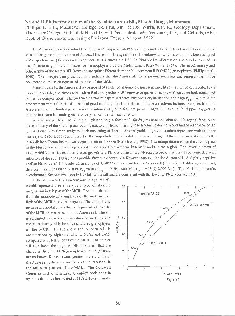
Nd and U-Pb Isotope Studies of the Syenitic Aurora Sill, Mesabi Range, MinnesotaPhillips, Erin H., Macalester College, St. Paul, MN 55105; Wirth, Karl R., Geology Department,Macalester College, St. Paul, MN 55105, [email protected]; Vervoort, J.D., and Gehrels, G.E.,Dept. of Geosciences, University of Arizona, Tucson, Arizona 85721
The Aurora sill is a concordant tabular intrusion approximately 5.6 km long and 6 to 37 meters thick that occurs in the
Mesabi Range north of the town of Aurora, Minnesota. The age of the sill is unknown, but it has commonly been assigneda Mesoproterozoic (Keweenawan) age because it intrudes the 1.88 Ga Biwabik Iron-Formation and also because of itsresemblance to granitic complexes, or "granophyres", of the Midcontinent Rift (White, 1954). The geochemistry andpetrography of the Aurora sill, however, are quite different from the Midcontinent Rift (MCR) granophyres (Phillips et al.,
2000). The isotopic data presened ho indicate that the Aurora sill has a Keweenawan age and represents a uniqueoccurrence of this rock type in this portion of the MCR.
Mineralogically, the Aurora sill is composed of albite, potassium-feldspar, aegerine, fibrous amphibole, chlorite, Fe-Ti
oxides, Fe sulfide, and zircon and is classified as a syenite (< 5% normative quartz or nepheline) based on both modal andnormative compositions. The presence of two feldspars indicates subsolvus crystallization and high P1120. Albite is thepredominant mineral in the sill and is aligned in fine-grained samples to produce a trachytic texture. Samples from theAurora sill exhibit limited geochemical variation (Si02=54.6-60.7 wt. percent; Mg#=0.4-0.75; Y=9-19 ppm) suggesting
that the intrusion has undergone relatively minor internal fractionation.A large sample from the Aurora sill yielded only a few small (60-80 jim) anhedral zircons. No crystal faces were
present on any of the zircon grains but it is unknown whether this is due to fracturing during processing or resorption of the
grains. Four U-Pb zircon analyses (each consisting of 3 small zircons) yield a highly discordant regression with an upper
intercept of 2970 ± 257 (2; Figure 1). It is improbable that this date represents the age of the sill because it intrudes the
Biwabik Iron-Formation that was deposited about 1.88 Ga(Fralick et al., 1998). Our interpretation is that the zircons grewin the Mesoproterozoic with significant inheritance from Archean basement rocks in the region. The lower intercept of
1190 ± 466 Ma indicates either zircon growth or a Pb loss event in the Mesoproterozoic that may have coincided withintrusion of the sill. Nd isotopes provide further evidence of a Keweenawan age for the Aurora sill. A slightly negativeepsilon Nd value of -1.4 results when an age of 1,100 Ma is assumed for the Aurora sill (Figure 2). If older ages are used,
they result in unrealistically high ENd values (ENd = +9 @ 1,800 Ma; ENd +23 @ 2,900 Ma). The Nd isotopic resultscorroborate a Keweenawan age (1 .1 Ga) for the sill and are consistent with the lower U-Pb zircon intercept.
If the Aurora sill is Keweenawan in age, the sillwould represent a relatively rare type of alkaline 0.6
magmatism in this part of the MCR. The sill is distinct
from the granophyric complexes of the northwesternlimb of the MCR in several respects. The granophyric 0.5
textures and modal quartz that are typical of felsic rocks
of the MCR are not present in the Aurora sill. The sill
is saturated to weakly undersaturated in silica and 0.4
contrasts sharply with the silica saturated granophyres
of the MCR. Furthermore the Aurora sill is
characterized by high total alkalis, Nb/Y, and Ce/Zr 0.3
compared with felsic rocks of the MCR. The Aurorasill also lacks the negative Nb anomalies that arecharacteristic of the MCR granophyres. Although there 0.2
are no known Keweenawan syenites in the vicinity of
the Aurora sill, there are several alkaline intrusions in
the northern portion of the MCR. The Coldwell01
Complex and Killala Lake Complex both containsyenites that have been dated at 1108 ± I Ma, near the
80
7Pb* 1235U
Figure 1

beginning of continental rifting (Heaman andMachado, 1992). Preliminary examination of thegeochemistry of these syenites displays similarities
to the Aurora sill. For example, they exhibit high
Nb/Y ratios and follow similar trends on manygeochemical plots (e.g., Na20+K20 versus Si02)and have broadly similar ENd values to the earlygabbro phases from the Coldwell complex(Heaman and Machado, 1992). Unlike theColdwell and Killala Lake complexes, the Aurorasill is not known to be associated with carbonitites.
The Nd isotopic and trace-element signatures
of the Aurora sill suggest that it was derived from
Age (Ga) a mantle melt that did not interact with older,evolved crustal materials. However, this
Figure 2 .
interpretation is not fully consistent with the U-Pb
zircon data which clearly indicate inheritance ofolder zircons. It is difficult to imagine a process whereby zircons are inherited from the extant Archean crust without that
crust contributing a highly unradiogenic Nd isotopic signature (negative ENd values) to the sill. This could occur if theassimilant was of low concentration and/or near-chondritic Sm/Nd ratios, but neither is a common characteristic of zirconbearing lithologies. One possibility is that the zircons in the Aurora sill have been derived from small degrees of assimilation
of Biwabik Iron-Formation or related Animikie sediments. These sediments have variable but generally less negative Evalues in the Mesoproterozoic (Hemming et al., 1995) and also contain Archean detrital zircons.
The age of the Aurora sill is important to understanding the timing of ore formation in the Mesabi Range. In 1999,Morey proposed a conceptual model in which the high-grade ores formed in a regional ground-water system duringPaleoproterozoic time (1.6-2.5 Ga). Subsequently, Graber and Strandlie (1999) argued that nearby high grade ores musthave formed in Mesoproterozoic or later time, because the Aurora sill appears to have controlled ore-forming processes in
nearby mines. Since a Keweenawan Aurora sill could not have had an effect on ore-formation in the Paleoproterozoic, it is
not possible at this time to confirm the model described by Morey (1999).
References Cited
Fralick, P.W., S.A. Kissin, and D.W. Davis, 1998, The Age and Provenance of the Gunflint Lapilli Tuff. Institute on
Lake Superior Geology, Proceedings and Abstracts, p. 66-67.Graber, Ronald G. and Alan J. Strandlie, 1999, Where are the Metamorphosed Natural Orebodies of the Mesabi Range?
Institute on Lake Superior Geology, Proceedings and Abstracts, p. 17-19.Heaman, L.M. and Machado, N., 1992, Timing and origin of the Midcontinent rift alkaline magmatism, North America:
Evidence from the CoIdwell complex. Contributions to Mineralogy and Petrology, V 110, p. 289-303.
Hemming, S.R., S.M. McLennan, and G.N. Hanson, 1995, Geochemical and Nd/Pb isotopic evidence for the provenanceof the Early Proterozoic Virginia Formation, Minnesota. Implications for the tectonic setting of the Animikie
basin, Journal of Geology, V 103, p. 147-168.Morey, G.B., 1999, High-Grade Iron Ore Deposits of the Mesabi Range, Minnesota Product of a Continental-Scale
Proterozoic Ground-Water System. Economic Geology, V 94, p. 133-142.
Phillips, E.H., 2000, Petrogenesis of the Enigmatic Aurora Sill, Mesabi Range, Minnesota, Unpublished honors thesis,
Macalester College, St. Paul, MN.Phillips, E.H., K.R. Wirth, and G.B. Morey, 2000, Petrogenesis of the Enigmatic Aurora Sill, Mesabi Range, Minnesota.
Institute on Lake Superior Geology, Proceedings and Abstracts, p. 51-52.White, David A., 1954, The Stratigraphy and Structure of the Mesabi Range, Minnesota. Minnesota Geological Survey
Bulletin 38. Minneapolis: The University of Minnesota Press, p. 63-66.
E (T)Nd
81

Freeze/Thaw Testing of Carbonate Aggregate Sources in Wisconsin — AStatus Report
Daniel D. Reid, Wisconsin Department of Transportation, 3502 Kinsman BlvcL, Madison,Wisconsin 53704-2507
Delamination and deterioration of exposed pavement aggregates has been a common occurrenceon highways in southern and northeastern Wisconsin, and has lead to highway maintenanceproblems in some areas. The principal cause of these problems is crushed stone aggregateproduced from Sinnipee Group (Galena, Decorah and Platteville Formations) rock. Prior to1999, the Wisconsin Department of Transportation (WisDOT) excluded entire formations andmembers of the Sinnipee Group as a way of mitigating pavement problems. A study of carbonateaggregate resources in Wisconsin, conducted jointly by WisDOT and the Wisconsin Geologicand Natural History Survey (WGNHS), provided a comprehensive analysis of the stratigraphyand geologic properties of Sinnipee Group aggregate resources. This study identified significantregional variability in Sinnipee Group rock, and concluded that the laboratory freeze/thaw testwas the most effective method of identifying problem aggregate sources. Based on this data,WisDOT concluded that specifications excluding certain formations and members were notappropriate for uniform application across the entire state.
As a result of the WisDOT/WGNHS carbonate aggregate study, WisDOT developed andimplemented specifications for freeze/thaw testing of carbonate aggregate sources used inpavements and bridge decks in October 1999. These specifications mandated freeze/thaw testingin counties where Sinnipee Group rock outcrops, and set the threshold for loss at 18% by weight.Included in the specifications was a clause that allows WisDOT to waive freeze/thaw testing forexisting aggregate sources determined to be in the Silurian System or Prairie du Chien Group ofcarbonate rocks. WisDOT has now completed over 230 independent freeze/thaw tests oncarbonate aggregate source material throughout Wisconsin. To date, the results indicate thatfreeze/thaw testing is performing it's intended function. A decrease in pavement problems hasbeen reported and WisDOT now has an effective method of controlling aggregates that produceexcessive delamination. As an added benefit, aggregate producers are now permitted to useaggregate sources that were excluded prior to establishment of the freeze/thaw testingspecification, so long as material from these sources tests under the 18% threshold.
References: -
AASHTO, 1996, Standard Specification for Soundness of Aggregates by Freezing and Thawing,American Association of State Highway and Transportation Officials (AASHTO) DesignationT 103-91.
Brown, Bruce A., 1999, Aggregate Resources of the Sinnipee Group in Eastern and SouthernWisconsin, Wisconsin Geologic and Natural History Survey Open-File Report 1999-07.
Ostrom, M.E., 1967, Paleozoic Stratigraphic Nomenclature for Wisconsin, Wisconsin Geologicaland Natural History Survey Information Circular No. 8.
82

A Metamorphosed Evaporite Sequence from the Sibley Basin
___
Rogala, B. and Fralick, P.W., Department of Geology, Lakehead University, ThunderBay, Ontario
The Sibley Group sediments were deposited in a subsiding infracratonic basin(Fralick and Kissin, 1995), between 1339 ± 33 Ma (Franklin et aL, 1980) and 1537 +10-2(Davis and Sutcliffe, 1984). The Group is divided into three main Formations: PassLake, Rossport, and Kama Hill, representing deposition in a braided fluvial-mudflat-playa environment (Cheadle, 1986). This study concentrates on a section through alateral correlative of the cyclic facies contained in the Rossport Formation present in theNoranda drill core NI-92-5. The location of this drill hole is north f iier cored sectionsand outcrops of the cyclic facies and represents a more basin center environment. Thecyclic facies to the south consists of alternating layers of dolomite and red shale withindividual layers, in the approximately 40 m thick assemblage, varying from mm- to dm-scale. In drill hole NI-92-5 the layering is at a similar scale, but is composed ofalternations between what was first thought to be dolomite-rich and gypsum-richintervals, reflecting wet and dry seasonality in the central playa environment.
SEM and XRD analysis indicate that the sequence was metamorphosed. Theprogression of metamorphic facies, from lower to higher T towards the diabase sill, isrepresented by the following reactions:
3CaMg(C03)2 + 4SiO2 +1H20 —' lMg3Si4Oio(OH)2 + 3CaCO3 + 3CO2and
5Mg3Si4O10(OH)2 + 6CaCO3 + 45i02 —. 3Ca2Mg5Si8O22(OH)2 + 6C02 + 2H20or
2Mg3Si4Oio(OH)2 +3CaCO3 - lCa2Mg5Si8O22(OH)2+ lCaMg(CO3)2 + 1CO2 +1H20or
5CaMg(C03)2 + 8SiO2 + 1H2O — lCa2Mg5Si8O22(OH)2 + 3CaCO3 + 7CO2(Winkler, 1974)
Near the diabase sill pargasite, a hornblende with the composition(Na,K)01Ca2Mg4A13Si6O22(OH), is the dominant mineral. Clinochlore, a chlorite mineralwith a composition of Mg5Al5Si3Oio(OH), is found throughout the metamorphic series.Both of these minerals are common in magnesian carbonate metamorphism (Pattison andTracy, 1991).
Primary layering has been masked in places by metamorphism. However, S.E.M.analysis clearly shows the mineralogical layering, reflecting variations in primarygeochemical constituents between individual laminae. ICP-AES analysis also highlightsthe varying compositions of the sequence. CafMg ratios indicate the precipitation ofgypsum in many layers. This is supported by the observation of gypsum using S.E.M..The pargasite tends to exist in layers with differing K and Na proportions. The K andNa ions may reflect the incorporation of KCI and NaC1. Both of the minerals are foundin S.E.M. sections taken near the middle of the sequence.
83

Clastic input is variable between individual layers, but shows an increase at thetop of the section. This increase is related to the appearance of sand sheets, whichtypically mark the end of the cyclic facies in the Sibley Group sediments. Clasticmaterial becomes slightly enriched in elements denoting a mafic rock source up-section.
The source material is distinctly alkalic. Alkalic material may be associated withplume activity, which would fit the infracratonic theory for the formation of the SibleyBasin. However, suitably alkalic rocks have not been found in the area.
References
Cheadle, B.A. 1986. Alluvial-playa sedimentation in the lower Keweenawan SibleyGroup, Thunder Bay District, Ontario. Canadian Journal of Earth Sciences, 23,527-542.
Davis, D.W. and Sutcliffe, R.H. 1984. U-Pb ages from the Nipigon Plate and NorthernLake Superior. Geological Society of America Bulletin, 96, 1572-1579.
Fralick, P. and Kissin, S. 1995. Mesoproterozoic basin development in central NorthAmerica: implications of Sibley Group volcanism and sedimentation at RedstonePoint. in: Petrology and metallogeny if volcanic and intrusive rocks of the mid-continent rift system, Proceedings of the International Geological CorrelationProgram, Project 336.
Franklin, J.M., Mcllwaine, W.H., Poulsen, K.H. and Wanless, R.K. 1980. Stratigraphyand depositional setting of the Sibley Group, Thunder Bay District, Ontario,Canada. Canadian Journal of Earth Sciences, 17, 633-651.
Pattison, D.R.M. and Tracy, R.J. 1991. Phase equilibria and thermobarometry ofcalcareous, ultramafic, and mafic rocks, and iron formations. In: Kerrick, D.M.(ed.), Contact Metamorphism. Reviews in Mineralogy, 26, Mineralogical Societyof America.
Winkler, H.G.F. 1974. Petrogenesis of Metamorphic Rocks. Springer-Verlag: NewYork Inc., 320 p.
84

Roles of Fractional Crystallization and Assimilation in the Production ofMidcontinent Rift Granophyres.
Sandland, Travis 0., ([email protected]) & Wirth, Karl R., Geology Department,Macalester College, St. Paul, MN, 55105; Vervoort, Jeff D. & Gehrels, George E., Departmentof Geosciences, University of Arizona, Tucson, AZ, 85721; Kennedy, Bryan C., GeologyDepartment, Macalester College, St. Paul, MN, 55105; Harpp, Karen S., Department ofGeology, Colgate University, Hamilton, N 13346
The granitic complexes of the Midcontinent Rift (MCR), commonly termed granophyres,comprise a significant portion of the Duluth Complex in northern Minnesota. They range in size from30 to 150 km2 in surface area and are ito 2 km in thickness. They consist of basal diorite and monzodioriteand progress upward to quartz monzodiorite, granodiorite, and granite. This study focuses on thepetrogenesis of four of these complexes: the Greenwood Lake, Misquah Hills, Eagle Mountain, andPine Mountain granophyres.
Miller and Vervoort (1996) identified two magmatic stages in this part of the MCR. An "earlystage" from 1108-1105 Ma, and a "main stage" from 1100-1094 Ma. The four granophyre complexesaddressed in this study have U-Pb zircon ages consonant with this chronology. The older granophyresinclude the Misquah Hills and Greenwood Lake complexes with ages of 1106±6 Ma and 1106±3 Ma(±2 sigma), respectively, and were emplaced during the early stage of the rift. The Eagle Mountain andPine Mountain granophyres have ages of 1098±4 and 1095±4 Ma, respectively, and were emplacedduring the main magmatic stage.
The granophyre complexes vary widely inFigure 1 composition (47-76 wt. % Si02) and plot as linear
trends on many Harker variation diagrams. Thetwo granophyre groups (early and main stage) areindistinguishable on such plots and appear to have
ci very similar major element chemistry.Incompatible trace elements (including REEs) areenriched in both groups (Fig. 1) although the earlystage granophyres generally have higherconcentrations than the late stage granophyres.Incompatible trace element ratios (e.g., LaISm, Gd!Yb) are similar for both groups. The early stagegranophyres have initial epsilon Nd values between
20La Pr Eu Tb Ho Tm Lu 0 and -2. In contrast, the main stage granophyres
Ce Nd Sm Gd Dy Er Yb are isotopically enriched, with initial epsilon Ndvalues between -3 and -8.
The isotopic and incompatible element data suggest both fractional crystallization (FC) andassimilation fractional crystallization (AFC) processes were involved in the evolution of the granophyres.The large negative epsilon Nd values associated with the main stage granophyres indicate AFC processesand suggest contamination by an isotopically enriched source, possibly felsic Archean crustal rocks.This trend can be seen on a graph of epsilon Nd vs. La/Yb (Fig. 2). The main stage granophyres also
85

have low Nb/Y ratios, a signature of contamination by crustal materials, whereas the Nb/Y ratios of theearly stage granophyres are positively correlated with La/Sm (Fig. 3). If AFC processes were activeduring the formation of the early stage granophyres, the assimilant was likely limited to juvenile maficrocks with little or no isotopic enrichment. Alternatively, the enrichment of incompatible elements inthe early stage granophyres could be the result of fractional crystallization.
Figure 2 Figure 320
10 -
Early Stage.Main Stages
0 I I I I I I
Epsilon Nd
These data support the model of rift evolution as presented by Vervoort and Green (1997). Theearly stage granophyres were formed either by fractional crystallization, or by AFC processes withcontamination from a high Sm/Nd mafic crust. During this stage of rift evolution, the middle to uppercrust was probably relatively cold, so assimilation likely occurred in the lower crust due to local heatingas a result of plume initiation. The main stage granophyres are isotopically contaminated and suggestAFC processes at work. During this time period, renewed rifling resulted in higher ambient temperaturesin the crust, and allowed melting of older, low Sm/Nd, negative epsilon Nd sources, possibly at middleto upper crustal levels.
References:
Miller, J.D., Vervoort, J.D., 1996, The latent magmatic stage of the Midcontinent rift: a period ofmagmatic underplating and melting of the lower crust. in 42" Annual Meeting of the Instituteon Lake Superior Geology, Cable, Wis., May 1996, Proceedings volume 42, pp 33-35.
Vervoort, J.D., and Green, J.C., 1997, Origin of evolved magmas in the Midcontinent rift system,northeast Minnesota: Nd-isotope evidence for melting of Archean crust: Canadian Journal ofEarth Sciences, v. 34. p. 52 1-535.
86
2
AFCFC
-8 -7 -6 -5 -4 -3 -2 -l0
La/Sm

DIRECT TIMING CONSTRAINTS ON PALEOPROTEROZOICMETAMORPHISM, SOUTHERN LAKE SuPERIOR REGION: RESULTSFROM SHRIMP U-PB DATING OF METAMORPHIC MONAZITES
Schneider, D.A., Syracuse University, Syracuse, NY, 13244; Hoim, D.K., Kent StateUniversity, Kent,OH, 44242; Hamilton, M.A., Geological Survey of Canada, Ottawa,
ONT, K1A 0E8
The age of the Penokean Orogeny has been firmly established for decades by U-Pbpluton age data. The timing of post-orogenic cooling and lower temperature overprintinghas only been established more recently by thermochronologic investigations. Littleinformation exists however on the timing of the initial higher-grade metamorphismwhich affected the southern Lake Superior region during the Paleoproterozoic. Suchinformation represents a critical missing link in our understanding of the tectonothermalevolution of the crust during and after Penokean orogenesis. Monazite, a REE-phosphate accessory mineral, grows as a common metamorphic phase underamphibolite and higher-grade conditions. Monazite U-Pb ages typically yield reliableestimates for the timing of peak metamorphism, although post-metamorphicdeformation and fluid flux can cause lower-temperature monazite dissolution andreprecipitation. We utilized the SHRIMP at the GSC in Ottawa to obtain geochronologicinformation on distinct mineral domains (e.g., core vs. rim) which may have resultedfrom particular tectonothermal events. Through BSE imaging prior to analyses, wefound rim textures spatially distinct from interior replacement textures. Age data areindistinguishable from each domain and replacement probably resulted from the samethermal event as the rim neogrowth. Age data summarized below include onlyconcordant or near concordant analyses and are reported as weighted average207Pb/206Pb ages.
In this pilot study we separated monazite from an amphibolite grade Paleoproterozoicmetasedimentary unit in east-central Minnesota (Kettle River locality) and from anArchean gneiss unit within the Peavy district, northern Michigan (Foster City locality).From Kettle River, a sample of garnet schist, which attained peak metamorphicconditions of 470-520°C at 5-6 kbar, yielded distinct populations of core and rim U-Pbages from 5 monazite grains. Eight analyses of core domains yielded a U-Pb monazitecrystallization age of 1834.0 ± 6.1 Ma, reflecting primary metamorphic growth. Apopulation of monazite rimlreplacement spot analyses, characterized by a higher Thcontent, yielded an age of 1792.9 ± 4.3 Ma. This latter age is similar to the --1799 MaU-Pb crystallization age of the deformed Hillman tonalite (Van Schmus et aL, 2000,ILSG and this volume). From Foster city (>500°C and -4 kbar), an Archean muscovite-biotite quartzofeldspathic gneiss yielded a monazite core age of 1834.4 ± 6.0 Ma from10 spots on 11 grains. Rimlreplacement domain analyses from 9 spots yielded a youngerage of 1809.8 ± 6.3 Ma, consistent with high-temperature cooling in the region (1800and 1785 Ma Ar-Ar hornblende ages; Mancuso et al., ILSG, 1997).
87

These metamorphic U-Pb ages are the first reliable metamorphic dates from thisPaleoproterozoic orogen and indicate a widespread thermal pulse at 1835 Ma in responseto accretion-induced crustal thickening. Albeit preliminary, the age of metamorphism isremarkably consistent across the orogen. High temperature Ar-Ar cooling ages onhornblende (—500°C) from north of the Watersmeet dome (—1822 Ma; Schneider et a!.,1996, CJES) and biotite Ar-Ar dates from low-grade structural panels from east-centralMinnesota (1840-1830 Ma; Schweitzer et al., 2000, ILSG) are compatible with an —1835Ma orogenwide metamorphic episode. Further accessory mineral geochronology holdspromise for better elucidating the timing of syn-orogenic metamorphism, as well asoverprinting post-orogenic events throughout the southern Lake Superior region.
0.35
Foster CityArchean mu-bi quartzofeldspathic schist
-aa.
(p0
0.33
1:
0.31
0.29
0.274.2 4.4
0.33
0.31
0.29
0.274.2 4.4 4.6 4.8 5.0 5.2 5.4 5.6
88

RESULTS OF IGNEOUS THERMOMETRY AND BAROMETRY ON THE EAST-CENTRALMINNESOTA BATIIOL1TH: EVIDENCE FOR POST-EMPLACEMENT EXHUMATION ANDCOOLING
SCHWEiTZER, D., and HOLM, D., both at Dept of Geology, Kent State University, Kent; OH,44242; VAN SCHMUS, W.R., Dept. of Geology, Univ. of Kansas, Lawrence, KS, 55045;BOERBOOM, T., Minnesota Geological Survey, 2642 University Avenue, St Paul, MN
The internal zone of the Penokean orogen in east-central Minnesota was invaded by abundantplutonism associated with emplacement of the East-Central Minnesota Batholith (ECMB) from 1787 to 1772Ma (Van Schmus et al., 2000). Previous application of the Aluminum-in-Hornblende (AH) igneous barometeron phases of the ECMB indicate paleodepth estimates that increase from -13 km in the north (Ka-F, K-4; Fig1) to —18 km in the southeast near St Cloud (SC, Fig 1). HoIm aed others (1998) inferred the depthdifferences to reflect intrusion of different magma bodies into a rapidly unroofing terrane. This interpretationpredicts that progressively younger intrusions would have been emplaced into progressively shallower crustallevels. At the time, their hypothesis was limited by the lack of any precise age data on the intrusions analyzed.The new ECMB U-Pb age data provides the framework to directly test this hypothesis of syn-emplacementexhumation.
We selected six new samples for further All barometric work (starred localities, Fig 1). Andersonand Smith (1995) outlined the important role that temperature plays in the Al concentration in homblende rimsand proposed a temperature correcting calibration for the application of the All barometer. For this reason,the Hornblende-Plagioclase (HB-PL) thermometer (Blundy and Holland, 1992) was applied to these samples inorder to derive a crystallization temperature estimate for each sample. The Schmidt (1992) pressure calibrationis presented in order to compare the effects of the temperature correction. The electron microprobe at theUniversity of Maine, Orono was used to obtain compositional data used for both the All barometer and HB-PLthermometer. The results of these analyses are summarized in the following table.
Table 1: Summary of igneous thermometry and barnmetry resultsAn Content B and H, 1990 Schmidt, 1992 A and S, 1995
Sample ID Rock Unit (%) Temperature (°C) kbar kbar
EC-31 Granodiorite 49.99 789 ± 38 9.1 ± 0.6 <6.5 ± 0.6
EC-15 Mafic Plug 59.35 884±38 13.4 ± 0.6 <6.2 ± 0.6
DS-99-17 Anne Lake Granite 31.29 745 ± 38 6.0 ± 0.6 4.9 ± 0.6
EC-1 Watab Quartz Dionte 40.01 6% *38 5.2 ± 0.6 5.0 ± 0.6
EC-35 Granodiorite 43.77 746±38 8.5 ± 0.6 <7.2 ± 0.6
RFG-7 Reformatory Granodiorite 51.31 783 ± 38 6.4 ± 0.6 4.4 ± 0.6
Assuming an average overburden density of 2.7 g/cc, the pressures recorded by EC-31, EC-15, andEC-35 correspond to maximum emplacement depths of 23-27km. These appear to be anomalously high whencompared to other rocks in the area and probably reflect artificial Al enrichment of hornblende crystal rims dueto high An content. Samples RFG-7 (17 lan), EC-1(18 km), and DS-99-17(18 km) when corrected fortemperature effects appear to preserve viable estimates since they are consistent with prior barometric results.
In the north, samples Ka-F and K-4 (Fig. 1) both preserve emplacement depths of 13 km but their U-Pb ages are 15m.y. apart. To the south, all samples near St Cloud record —17-18 km depths regardless of age.This implies that very little uplift occurred during emplacement of the ECMB. The bulk of post-tectonicexhumation appears to have occurred after the emplacement of the ECMB. Preserved pressure differencesprobably reflect deeper emplacement depths (from N to 5) across the batholith. Post-emplacement exhumationis consistent with cooling ages being 10-20 m.y. younger than ciystallization ages from the batholith (Holm etal, 1998; Hohn and Lux, 19%). The ECMB was likely completely exhumed prior to deposition of the EarlyProterozoic (1750-1650 Ma) red quartzites.
89

—
c-i —
J .,- —.
, , _, __'_l—
; _s— —
10 km, -, I
F / // I, / \
' 'I'—''- ' — —'
Figure 1: Simplified map of the internal zone of the Pekonean orogen. Localities marked withfilledcircles represent samples analyzed by Hotm et at (1998). Starred localities denote samples analyzedin this study. MSD = Malmo Structural Discontinuity; SC = St. Cloud; LF = Little Falls. U-Pb ages after
Van Schmus et at (2000).
ReferencesAnderson, J.L, and Smith, D.R, 1 995,The effects of temperature and oxygen fugacity on the Al-in
-hornblende barometer: American Mineralogist, v.80, p.549-559.Blundy, J.D., and Holland,TJ.B, 1990, Calcic amphibole equilibria and a new amphibole-plagiodase
geothermometer: Contributions to Mineralogy and Petrology, v.104, p.208-224.HoIm, D.K.and Lux, D.R, 1996, Core complex model proposed for gneiss dome development during
collapse of the Paleoproterozoic Penokean orogen, MN: Geology, v.24, p.343-346.Holm, D.K., Darrah, KS., and Lux, D.R., 1998, Evidence for widespread —.1760 Ma metamorphism and
rapid stabilization of the Early-Proterozoic (1870-1820 Ma) Penokean orogen, MN: Am. J. ofScience, v.298, p.60-81.
Schmidt, M.W., 1992, Amphibole compoisition in tonalite as a function of pressure: an experimentalcalibration of the Al-in-hornblende barometer: Contributions to Mineralogy and Petrology,v.1 10, p. 304-310.
Van Schmus,W.R., MacNeill, LC., Holm, D.K, Boerboom,TJ., and isa, M.A., 2000,The 1787-1772 Maeast-central Minnesota batholith: Precursor to crustal stabilization in the Lake Superior region:ILSG proceedings, 46th annual meeting, Marquette, Ml, v.46, p.65-66.
MSD:
:-::•::-: 18±2km
(MSD) l P16
MN-29
H ,.- — S —'\ I
Is It Is '11787*; ___- I_/'-'/ -,
' \I— s. ' I<23*2km
A — -. / ',—
I— —
_s.-%.— •5_
,c—I___ \ I_,>.,,-I, ' ,Is *
-. I
5. 5—— / <24t2kI
90

A SYNOPSIS OF ARCHEAN AND PROTEROZOIC PLATINUM GROUP ELEMENTMINERALIZATION IN THE THUNDER BAY DISTRICT, ONTARIO
SMYK, Mark C., MASON, John K. and SCHNIEDERS, Bernie R., Ontario Geological Survey,Ministry of Northern Development and Mines, Suite B002, 435 James St. South, Thunder Bay,ON P7E 6S7, and STOTT, Greg M. Ontario Geological Survey, Ministry of NorthernDevelopment and Mines, Willet Green Miller Centre, 933 Ramsey Lake Road, Sudbury, ON P3E6B5
Platinum group element (PGE) occurrences and deposils are in both Neoarchean and Mesoproterozoicmafic to ultramafic intrusive rocks in the Thunder Bay District. Recent, dramatic increases in platinumgroup metal prices have prompted renewed interest in PGE exploration, resulting in the discovery ofhitherto unknown hosts and styles of mineralization.
Archean
There are four broad, temporally diverse settings for Neoarchean PGE mineralization:
(1) Pre-tectonic, mafic to ultramafic, subvolcanic(?) intrusions intimately associated with greenstonebelts of various ages in the Wawa and Wabigoon subprovinces;(e.g. Haines Gabbro (Shebandowan belt / Wawa; 2722 Ma); Core Zone gabbro (Obonga Lake belt/ Wabigoon; 2733 Ma);
(2) Post-tectonic, mafic to ultramafic intrusions (Ca. 2692 Ma), related to late plutonism in theWabigoon Subprovince, hosted by gneissic tonalite-granodiorite(e.g. Lac des Iles and Tib Lake complexes; Buck Lake, Legris Lake, etc.);
(3) Syn- to post-tectonic, mafic to ultramafic intrusions (a.k.a. "Quetico-type"; Ca. 2680 to 2688 Ma)hosted by Quetico subprovince metasedimentary rocks(e.g. Samuels Lake, Kawene, Nym Lake, Chief Peter Lake, North Elbow Lake, etc.); and
(4) Mafic intrusive rocks occurring within syn- to post-tectonic, diorite-monzodiorite-monzonitesuites with sanukitoid affinity (ca. 2680 to 2685 Ma), within the Wabigoon, Quetico and Wawasubprovinces (cf Stern eta!. 1989)(e.g. Roaring River Complex; Entwine Lake).
Disseminated to locally net-textured chalcopyrite, Fe-sulphides, pentlandite and magnetite typicallycharacterize PGE-mineralized zones, which are commonly associated with intrusive contacts, polyphaseintrusive breccias, as well as sheared and hydrothermally altered zones.
Proterozoic
Mesoproterozoic intrusive rocks associated with the Midcontinent Rift locally range in age from Ca. 1108Ma (e.g. reversely polarized Coldwell alkaline complex; Logan diabase) to ages younger than the magneticpolarity reversal that occurred between 1105 and 1102 Ma (Davis and Green 1997). A tabulated synopsisis provided below:
91

Normal Magnetic Polarity<(1005-1102 Ma):
The development of tectono-magmatic models for these various suites of intrusions is the focus of ongoingresearch as part of the Ontario Geological Survey's Operation Treasure Hunt. These new data will providenew insights into late Archean subprovince accretion in the Superior Province, as well as the developmentof the Midcontinent Rift. They will help to elucidate possible links between the age, geochemistry andsetting of these intrusive rocks and PGE mineralization processes in order to generate new explorationtargets.
References
Davis, D.W. and Green, J.C. 1997. Geochronology of the North American Midcontinent rift in westernLake Superior and implications for its geodynamic evolution; Canadian Journal of Earth Sciences,V.34, p.476-488.
Stern, R.A., Hanson, G.N. and Shirey, S.B. 1989. Petrogenesis of mantle-derived, LILE-enriched Archeanmonzodiorites and trachyandesites (sanukitoids) in southwestern Superior Province; CanadianJournal of Earth Sciences, v.26, p.1688-1712.
92
Intrusion I Lithology Mineralization Style Local Examples(Associated PGE-Miizeralized Areas)
ULayered(?) picritic ultramafic
intrusionsDisseminated sulphides and
native metals in lherzolite, dunite,peridotite,_etc.
Leckie Lake (Wolf Mountain);Hele Township; Eva-Kitto townships
Layered gabbro-anorthositicintrusions:
Crystal Lake Gabbro
Disseminated and blebbysulphides in medium- to coarse-
grained, varied-textured
Crystal Lake Gabbro
(Great Lakes Nickel deposit)
(a.k.a._'taxitic')_gabbroDisseminated sulphides in Cr- (Cr-spinel-bearing, anorthositicspinel-bearing cumulate layers gabbro above Cu-Ni deposit)
Pine Point - Mount Mollie Disseminated, intergranular (Mount Mollie; Pine River)Gabbro sulphides, fracture fillings
Pigeon River and Arrow River Disseminated sulphides in (Wallenius; Naomi Island; Jarvisdiabase dykes medium- to coarse-grained Point)
gabbro_and_diabase
Reversed Magnetic Polarity(ca. 1108 Ma):
Logan diabase sills, cone sheetsI
Sparse, disseminated sulphides (Numerous)
Tholeiitic to alkalinecomplexes:
Disseminated sulphides inmedium- to coarse-grained,
Coldwell Killala Lake
Two Duck Lake BorderCoIdwell alkaline complex
Killala Lake alkaline complexvan-textured (a.k.a. taxitic)
gabbrogabbro
(Marathon deposit);gabbro
(Sandspit -Geordie Lake gabbro Killala)
Disseminated sulphides in Eastern Border gabbro (Unknown)massive Fe-Ti-oxide (Skipper Lake zone)
cumulate layers

PLATINUM GROUP ELEMENT EXPLORATION IN NORTHWESTERN ONTARIO
SMYK, Mark C., S11IWART, Jennifer and O'BRIEN, Mark S. Ontario Geological Survey,Ministry of Northern Development and Mines, Suite B002, 435 James St. South, Thunder Bay,ONP7EÔS7
During the past two years there has been a marked increase in exploration for the platinum-group elements(PGE) In iiorthwestern Ontario. This interest has been driven by a dramatic rise in the prices of platinumand palladwm. Renewed PGE exploration in northwestern Ontario has also been significantly influencedby the sticcess of North American Palladium Ltd.'s Lac des Ties Mine which produced 95 116 ounces of-palladium at àcash cost of US$142 per ounce in 2000. Recent exploration efforts at Lac des lies haveincreased 'the measured and indicated resource to 145 600 000 tonnes at an average grade of 1.57 glt Pd,0.17 g/t Pt, 0.12 g/t Au, 0.06% Cu and 0.05 % Ni.
There were over 100 PGE exploration programs in northwestern Ontario in 2000, accounting for more thanhalf of all mineral exploration in the region. These exploration efforts have focused on both Archean andProterozoic mafic to ultramafic intrusions, leading to the discovery of many occurrences in areas andlorintrusions not previously known to host PGE mineralization.
PGE occur in two main geological settings:
(1) In Archean pre- to post-tectonic, mafic to ultramafic intrusions. Mineralization may be associatedwith:
• Disseminated "sparse" sulphides in gabbro and ultramafic rocks (e.g. Lac des Ties complex andsatellite intrusive complexes), and localized by:• Zones of hydrothermal alteration• Heterolithic, igneous breccia zones• Contact zones and tectonic structures
• (Semi-) massive, sheared, copper-nickel sulphide deposits (e.g. Shebandowan and Thierry mines) inultramafic rocks
• Sheared ultramafic rocks with copper-nickel sulphides intruding banded iron formation(e.g. Trout Bay)
• Chromitite within layered ultramafic complexes (e.g. Big Trout Lake, Chrome Lake?)
(2) In Mesoproterozoic, Midcontinent Rift-related (ca. 1108-1102 Ma), mafic to ultramafic intrusionsnear Lake Superior and Lake Nipigon. Mineralization may be associated with:
• Disseminated suiphides in coarse-grained to pegmatitic, van-textured ("taxitic") gabbro(e.g. Great Lakes Nickel; Marathon deposits)
• Massive oxide (± sulphide) units in layered gabbro (e.g. Coidwell Eastern Gabbro (Ti-Fe-oxides);Great Lakes Nickel (Cr-spinel)
• Disseminated sulphide ± native metals in olivine-rich, layered ultramafic rocks (e.g. Wolf Mountain)
93

A NEW GRAVITY MAP OF WISCONSIN
SNYDER, Stephen L., U.S. Geological Survey, MS 954 National Center, Reston, VA 20192,[email protected]; ERVIN, C. Patrick, Dept. of Geology and Environmental Geosciences,Northern Illinois University, DeKalb, IL 60115, [email protected]; GEISTER, Daniel W., Dept. ofGeology and Environmental Geosciences, Northern Illinois University, DeKalb, IL 60115,[email protected] and DANIELS, David L., U.S. Geological Survey, dave(usgs.gov.
A new Bouguer anomaly gravity map of Wisconsin has been created from more than 37,000gravity measurements collected between 1948 and 2000. North of latitude 44° N., more than 28,000stations were compiled by C.P. Ervin and M.E. Thompson. These data include stations from theWisconsin Geological and Natural History Survey (WGNHS), the National Geophysical Data Center(NGDC), the Defense Mapping Agency (DMA), the U.S. Geological Survey (USGS), and NorthernIllinois University. An approximate station interval of 1 mile (1.6 km) was established where possible,but limited access in some areas necessitated a greater spacing.
Prior to 1999, the data south of latitude 44° N. totaled approximately 3800 stations from NGDCand from G. Randy Keller (University of Texas-El Paso). The current USGS effort, begun in 1999, isdirected at upgrading the gravity coverage of the state south of latitude 44° N. with a station densitycomparable to that north of 44° N. To date we have added measurements at more than 6800 stations toachieve a nominal spacing of one to two miles. These new data replace the older data from the NGDC,which had a nominal station spacing ranging from 3 to 10 miles. Nearly all of the data are tied to theWisconsin First-order Gravity Base Station Network, which is in turn tied to the International GravityStandardization Network-1971 (IGSN-71). The 37,000 measurements were then gridded at an interval of500 m. The map will be presented at a scale of 1:500,000.
The rationale for upgrading the gravity coverage has been to provide higher resolution data toassist in the interpretation of the basement geology of southern Wisconsin, much of which is hidden byglacial and Paleozoic cover. The gravity data, along with aeromagnetic data, give clues to the structuralevolution of the Precambrian crust, making the map an excellent tool for USGS mineral resource studies.
Some notable features shown on this map include 1) the Midcontinent gravity high, which hasone of the steepest gravity gradients in the conterminous US, 2) the flanking gravity lows correspondingto Keweenawan sedimentary basins, 3) gravity highs over inferred mafic plutons in southeasternWisconsin, 4) a low centered on the Precambrian Wolf River batholith, but much larger in area, 5) gravitylows associated with granitic intrusives just south of latitude 46° N., and 6) several northwest trendinglinear features of unknown origin.
The accompanying figure shows a shaded relief image of the gravity map.
94

50 0 50
klometresNA027/ LGC-90
95
.5 H.15
21 .—.55 —27 .—30 .—33 —35—35 I
42 *45 —-45 *
51
54 *
50
53
-55
72
-51
500milhigals
92° -91 -89 880 -87°

POST-RIFT EVOLUTION OF THE MIDCONTINENT RIFT SYSTEM:SOME NUMERICAL EXPERIMENTS
Soofi, M. A., and King, S. D., Department of Earth and Atmospheric Sciences, PurdueUniversity, West Lafayette, Indiana 47907
The Midcontinent Rift system (MCR) is a major geological and geophysical featureof North America. This 1.1 b.y. old feature (Nicholson and Shirey, 1990; Klewin andShirey, 1992) is believe to have evolved first through the tensile forces of a rift originand then through the compressive forces from the intraplate collision between NorthAmerica and Grenville Tectonic Zone (GTZ) (Van Schmus and Hinze, 1985). Thesupport for interaction between the MCR and GTZ come from the geophysical studieswhich reveal thrust faults and folds along the length of the MCR (e.g., Zhu and Brown,1986; Chandler et al., 1989; Mariano and Hinze, 1994; Allen et al., 1997). Also, the timeof thrusting along the MCR is constrain to be 1060 Ma (Bornhorst et al., 1988; Cannonet al., 1993) which is comparable to 1100-1060 Ma (Easton, 1992) as the duration ofcollision in Grenville Tectonic Zone.
A quantitative study of the late-stage deformation of the MCR under the Grenvilletectonism has been performed by Soofi and King (1999). They showed that the distancebetween the MCR and Grenville Tectonic Zone is appropriate for the two geologicprovinces to interact. We expand on their findings and investigate the contributionof various factors involved in the collision between North America and the Grenvilleterranes, including: the size of colliding terranes of Grenville Tectonic Zone; the locationof collision along the eastern and southern boundaries of North America; and the angleof convergence between North America and the Grenville terranes. We use a 2D, viscous,finite element model that treats lithosphere as a thin sheet with stresses averaged overits thickness (for computational method see Houseman and England (1986); for programlocation see the web site http : / /www.earth.monash.edu.au/Research/Basil). The modelboundaries coincide with pre-Grenville collision boundary of North America. In themodel, the MCR is considered as a low-strength block. We consider the present shapeof the MCR as the shape at the time of collision with the Grenville terranes. The modelsare run to represent 21 Ma of convergence at the rate of 50 mm/yr. To constrain themodel results we use geophysically observed uplifts along the reverse faults of the MCR(e.g., Zhu and Brown, 1986; Mariano and Hinze, 1994; Allen et al., 1997). These upliftsare compared with crustal thickening along the MCR in the model.
Based on our results we conclude that the 3 to 8 km variation in uplift along thethrust faults of the western arm of the MCR is the consequence of size of the collidingterranes and location of the collision. The model results also suggest that deformationalong the eastern arm of the MCR was comparable to that along the western arm. Thereason we do not observe such deformation in geophysical studies (e.g., Zhu and Brown,1986) is, perhaps, due to later surficial and/or tectonic processes. We also conclude thatcollision with Crenville Tectonic Zone was active along both the eastern and southernboundaries of North America. This resulted in the non-linear shape of the westernarm of the MCR and may also played a role in the formation of the Belle Plaine fault.We do not observe any significant difference in the model results for different anglesof convergence between North America and Grenville terranes. Consideration of otherconstraints in addition to the uplift along the MCR may help to determine the dominantangle of convergence between North America and Grenville Tectonic Zone.
96

REFERENCES CITED
Allen,D.J., Hinze, W.J., Dickas, A.B., and Mudrey, M.G.Jr., 1997, tnterMedgeophys-ical modeling of the North American midcontineñt rift system: New thterpreta-tions for western Lake Superior, northwestern Wisconsin, and eastern Minnesota:Geological Society of America Special Paper 312, p. 47-71.
Bornhorst, T J, Paces, J B, Grant, N K, Obradich D, and Thiber, NkK 1988,
Ae f native copper mineralization, Ke-weenaw Peninula, Michigan: conmi(eiogy, v 83, p. 41,19-625
Cannon, W.F., Petermn, Z.E., and Sims, P.K., 193, Crustal- sca1ethrtisting andorigin of the Montreal river monocline - A 35 km thick cross-section of the mid-continent rift in northern Michigan and Wisconsin: Tectonics, v. 12, p. 728-744.
Chandler, V.W., McSwiggen, P.L., Morey, G.B., Hinze, W.J,, and Anderson, R.R.,1989, Interpretation of seismic reflection, gravity, and magnetic data across mid-dle Proterozoic mid-continent rift system, northwestern Wisconsin, eastern Min-nesota, and central Iowa: American Association of Petroleum Geologists Bulletin,v. 73, p. 261-275.
Easton, R.M., 1992, The Grenville Province and the Proterozoic history of central andsouthern Ontario, in Thurston, P.C. Williams, H.R., Sutcliffe, R.H., and Stott,G.M., eds., Geology of Ontario, Ontario Geological Survey, Special volume 4, Part2, p. 715-904.
Houseman, G., and England, P., 1986, Finite strain calculations of continental deforma-tion 1. Method and General results for Convergent zone: Journal of GeophysicalResearch, v. 91, p. 3651-3663.
Klewin, K.W., and Shirey, S.B., 1992, The igneous petrology and magmatic evolutionof the midcontinent rift system: Tectonophysics, v. 213, p. 33-40.
Mariano, J., and Hinze, W.J., 1994, Structural interpretation of the MidcontinentRift in eastern Lake Superior from seismic reflection and potential-field studies:Canadian Journal of Earth Sciences, v. 31, p. 619-628.
Nicholson, S.W., and Shirey, S.B., 1990, Midcontinent rift volcanism in the Lake Supe-rior region: Sr, Nd, and Pb isotopic evidence for a mantle plume origin: Journalof Geophysical Research, v. 95, p. 10851-10868.
Soofi, M.A., and King, S.D., 1999. A modified beam analysis effect of lateral forces onlithospheric flexure and its implication for post-rift evolution of the MidcontinentRift System, Tectonophysics, v. 306, p. 149-162.
Van Schmus, W.R., and Hinze, W.J., 1985, The midcontinent rift system: AnnualReviews of Earth and Planetary Science, v. 13, p. 345-383.
Zhu, T., and Brown, L.D., 1986, Consortium for continental reflection profiling Michi-
gan surveys: Reprocessing and results: Journal of Geophysical Research, v. 91,
p. 11477-11495.
97

THE COOL EARLY EARTH: OXYGEN ISOTOPE EVIDENCEFOR CONTINENTAL CRUST AND OCEANS ON EARTH AT 4.4 Ga
VALLEY, JW*, PECK, WH, KING, EM, Dept. of Geology + Geophysics, Univ. ofWisconsin-Madison; GRAHAM, CM, Dept. of Geology + Geophysics, EdinburghUniv., Scotland; and WILDE, SA, School of Applied Geology, Curtin Univ., Bentley,Western Australia, * [email protected]
Zircons preserve the best record of U-Pb crystallization age and oxygen isotoperatios of igneous rocks. The I8O of non-metamict zircon is unaffected even byhydrothermal alteration and high-grade metamorphism.
Ion microprobe analysis of detrital zircons from the —3 Ga Jack Hillsmetaconglomerate (Narryer Gneiss Terrane, Yilgarn Craton, Western Australia) yield U-Pb ages from 3.1 to 4.4 Ga (Fig. 1, SHRIMP II, ref 1) and I8O from 5 to 8 %c (Cameca
4f, ref 2). The 18O of these zircons averages 6.3, and is 1 per mil higher than that inequilibrium with the mantle and that of normal Archean granitic zircons (Fig. 2; 5.3±0.3%o, 5.5±0.4 %, respectively; ref 3). The distribution of mantle-like vs. mildly elevated18O values for magmas is constant from 2.7 to 4.4 Ga, and on 4 continents (Fig. 2).
The age of 4.404 ±0.008 Ga from one 200 im zircon is >99% concordant andrepresents the oldest recognized terrestrial material. This crystal is zoned in ö'80(5.0±0.7% vs. 7.4±0.7%o) and REEs (La=0.3 to 13.6 ppm), and contains inclusions ofSi02. REE patterns are HREE enriched with positive Ce and negative Eu anomalies;calculated melts are LREE enriched. Taken together, these results suggest crystallizationfrom a quartz-saturated granitic magma and thus the existence of continental crust,possibly in a setting like Iceland. The high 6180 portion of the crystal would be inequilibrium with a magma at 6'80(WR)= 8.5-9.5%. There is no known mantle reservoirwith such high values. '8O(WR) values above 8.5 are typical of "S-type" granites thathave melted or assimilated material that was altered by low temperature interaction withwater at the surface of the Earth (i.e., weathering, diagenesis, low T hydrothermalalteration). Thus the high 18O value of the 4.4 Ga zircon suggests that surfacetemperatures were cool enough for liquid water suggesting that the early steam-richatmosphere condensed to form oceans at that time.
The evidence for liquid water and oceans at 4.4 Ga suggests a Cool Early Earth.This contrasts with the Hot Early Earth and global magma oceans envisioned at 4.5-4.3Ga based on: an impact origin of the Moon (4.45-4.50 Ga), core formation, higherHadean radioactive heat production, and intense early meteorite bombardment (4). Thesurface of the Earth cools quickly to form a crust by radiation, but a magma ocean causedby these processes would persist beneath the initially thin crust for up to 400 m.y. (5) andmight erupt as massive flood basalts in response to major meteorite impacts, boilingsurface waters. The thermal contrasts presented by these lines of evidence are minimizedif the Moon and core formed earlier (-.4.5 Ga), if the Moon formed by a process notinvolving a Mars-size impactor, or if the early meteorite bombardment was less intense orirregular in timing. It is possible that periods of Cool vs. Hot Early Earth alternated, with
98

boiling of early oceans after major impact events followed by periods of cooler surfaceconditions. If life evolved in these seas, multiple extinctions before 3.9 Ga are suggested.
dD
U-Pb Zircon age (Ma)
Detrital Zirconfrom Jack HillsMetaconglomerate W74
(1) SA Wilde, JW Valley, WFI Peck and CM Graham (2001) Evidence from Detrital Zircons forthe Existence of Continental Crust and Oceans on the Earth 4.4 Gyr Ago. Nature. 409: 175-178.
(2) WH Peck, JW Valley, SA Wilde, and CM Graham (2001) Oxygen Isotope Ratios and RareEarth elements in 3.3 to 4.4 Ga zircons: Ion Microprobe Evidence for Early Archean high ö'80 ContinentalCrust. Geochim Cosmochim Acta, in press
(3) WH Peck, EM King, JW Valley (2000) An Oxygen Isotope Perspective on PrecambrianCrustal Growth and Maturation. Geology 28: 363-366; EM King, JW Valley, DW Davis, GR Edwards(1998) Oxygen isotope ratios of Archean plutonic zircons from granite-greenstone belts of the SuperiorProvince. Precam, Res 92: 365-387.
(4) HN Pollack (1997) Thermal Characteristics of the Archaean, in: de Wit and Ashwal (eds),Greenstone Belts, 223-232
(5) Y Abe (1993) Physical State of the Very Early Earth. Lithos 30:223-235
99
206Pb238
U
1.20
1.10
1 .00
0.90
0.80
0.70
0.60
0.50
0.40
0.30
0.20
0.10.
207 Pb/ 235U
7
6
-I- A A
+ mantle zircon aA
AVA 5.3±0.3%c A
£ AAA AV
£V
VA
0 A Jack Hills Australia
4,
,
V Barberton+ Superior Province
Scotland® Manitouwadge
Miscellaneous
22600 2800 3000 3200 3400 3600 3800 4000 4200 4400

NW U.PB AGES FROM MINNESOTA, MICHIGAN, AND WISCONSIN: IMPLICATIONS FORLATE PALEOPROTEROZOIC CRUSTAL STABILIZATION.
Van Schmus, W.R. ([email protected]) and MacNeil!, L.C., both at Dept. of Geology, Univ. of Kansas,Lawrence, KS 66045, HoIm, D.K., Dept. of Geology, Kent State University, Kent, OH 44242; andBoerboom, T. J., Minnesota Geological Survey, 2642 University Avenue, St. Paul, MN 55114.
As part of a comprehensive study of the East-Central Minnesota Batholith (ECMB: Boerboom and HoIm, 2000;Van Schmus et al., 2000), we have also determined the U-Pb ages of several rock units spatially and (or)temporally related to it. The samples fall into several categories (Table 1): (a) the McGrath Gneiss to the NE ofthe ECMB in Minnesota; (b) Penokean basement east of the ECMB in Minnesota; (c) post-Penokean, pre-ECMB rocks in Michigan and Minnesota, and (d) units coeval with or slightly younger than the ECMB inMinnesota and Wisconsin.
Table 1. New U-Pb Results from Minnesota, Michigan, and Wisconsin.
MNOO-0 1 Bradbury Creek granodiorite, 4 mi. south of Onamia, MNMNOO-02 Tonalitic gn., Hillman migmatite?, 3 mi. south of Onamia, MN
Multiple East Central Minnesota Batholith 1787 to 1772 MaVan Schmus et al. (2000); Boerboom and HoIm (2000)Includes EC-2, -4, -5, -15, and -25 of Jima and Chandler (1997)
V573-08 1754±llMaVS77-251 1749 ± 04 MaVS79-85 (pooled; all near)
concordia)1759 ± 02 Ma1746 ± 03 Ma
The oldest sample is from the McGrath Gneiss and confirms the late Archean age of that unit. Two samplesyielded Penokean ages. The Bradbury Creek granodiorite was dated by Goldich and Fischer (1986) at 1869 ± 5
Ma, and our date of 1877 ± 15 Ma is fully consistent with this. A tonalitic gneiss (MNOO-02) about one mile tothe north-northwest and mapped as Hillman migmatite yields a slightly younger, but statistically indistinct, ageof 1853 ± 10 Ma. We are investigating the possibility that the Bradbury Creek unit is more extensive thanoriginally defmed from aeromagnetic data. In any case, normal Penokean ages occur in eastern Minnesota, andPenokean basement forms the host crust for the ECMB.
Several samples yielded U-Pb ages close to 1800 Ma. The main units in Minnesota are late, undeformed (orless deformed) tonalite phases within the Hillman migmatite complex. Samples from three separate localitiesyield a mean age of 1798 ± 3 Ma for the tonalite. For one of these samples (MNOO-03), the tonalite datedintrudes deformed tonalitic gneiss similar to that of MNOO-02. At this time it appears that the protolith for theHillman migmatite may be Penokean, but that it was extensively injected by younger tonalite about 1800 Ma.
100
Sample
MNOO-07
Description Age
McGrath Gneiss, 2 mi. west of McGrath, MN 2550 ± 14 Ma
MN99-09MNOO-03MNOO-04AGR-1
Late tonalite in Hiliman migmatite, 3 mi. SE of Lastrup, MNLate tonalite in Hilhnan migmatite, 9 mi. west of Onamia, MNLate tonalite in Hilhnan migmatite, 13 mi. west of Onamia, MNHumboldt granite, Humboldt, MI (Hoim et aL, 2001)
1877±15 Ma1853 ± 10 Ma
1798 ± 03 Ma(composite of
all 3 samples)1805 ± 07 Ma
PF-99 Two-mica granite, Park Falls, WisconsinVS73-37 Radisson Granite, Radisson, Wisconsin
Amberg granite, 1 mi. north of Amberg, WILugerville granite, 1.5 mi. SW Lugerville, WILugerville granite, Rock Carry Rapids, 1 mi. E Lugerville, WI
1781 ± 14 Ma1776 ± 08 Ma
VS74-13 Observatory Hill rhyolite, 6 mi. south of Montello, WIVS73-02 Montello granite, Montello, WI

Further detailed sampling and geochronology will need to be done to test this option. In Upper Michigan analkali-feldspar granite near Humboldt yielded an upper intercept age of 1805 ± 7 Ma (HoIm et al., 2001). Theserocks define a distinct post-Penokean, pre-ECMB phase of magmatism in or near the southern part of theSuperior Province.
As reported previously (Van Schmus et al., 2000), the East-Central Minnesota Batholith was emplaced within arelatively short span of time 1787 to 1772 Ma. We analysed zircons from several drill core samples to the east(ursa and Chandler, 1997), and the results (Table 1: EC-2, EC-4, EC-5, EC-1 5, EC-25) extend the known areaof the ECMB. In order to determine whether units of the so-called "1760 Ma" suite of rocks in Wisconsin arecoeval with the ECMB, we reanalysed several samples from the senior author's collection, plus one new sample(PF-99) using single-grain analyses and more precise techniques. The westernmost samples (PF-99 and VS73-37) yield ages indistinguishable from those of the ECMB, suggesting that magmatism of that episode extended
into northwestern Wisconsin. In contrast, samples of the "1760 Ma suite" farther east (Amberg and Lugervillegranite) or farther south (Montello granite, Observatory Hill rhyolite) are distinctly younger, with ages of 1746to 1759 Ma. These ages are similar to Ar-Ar ages reported for the ECMB and indicate that the last majormagmatic pulse occurred about 1750 Ma.
Our new data now suggest three main post-Penokean pulses of magmatism about 25 m.y. apart in the southernLake Superior region: ca. 1800, 1775, and 1750 Ma. The origin of the thermal energy in each case is presentlyunknown. These ages fall within the time span of magmatism in the Yavapai province-northern Central Plainsorogen (inner accretionary belt; Van Schmus et al., 1993) and could correlate with pulses of northward directedsubduction associated with southward growth of the continent. Interestingly, the two older and deeper-seatedigneous bodies currently reside in Paleoproterozoic crust unaffected by younger Mazatzal deformation and
reheating (Holm Ct al., 1998). It appears that localization of the earlier pulses in the west (Minnesota) and north
(northwesternmost Wisconsin) may have contributed to the overall greater exhumation of these areas (compared
to most of Wisconsin) and that this in turn may have dramatically strengthened the crust in those regions. Wenote that crustal remelting and thinning after orogenesis can both contribute to an overall stronger continentallithosphere. One fmal note: reference to a "1760 Ma" suite in Wisconsin should probably now be discontinued,since those rocks formed in two pulses at about 1775 and 1750 Ma.
Boerboom, TJ., and Holm, D.K., 2000, Paleoproterozoic intrusive igneous rocks of southeastern StearnsCounty, central Minnesota. Minn. Geol. Survey, Rept. mv. 56, 36p + 1 map.
Goldich, S.S., and Fischer, L.B., 1986, Air-abrasion experiments in U-Pb dating of zircon. Chemical Geology,
v. 58, p. 195-215.Holm, D., Schneider, D., and Coath, C., 1998, Age and deformation of Early Proterozoic quartzites in the
southern Lake Superior region: Implications for extent of foreland deformation during final assembly of
Laurentia: Geology, v. 26, p. 907-910.Holm, D., Van Schmus, R., Boerboom, T., and Jirsa, M., 1999, Role of post-Penokean granite genesis in crustal
stabilization in the Lake Superior region, north-central United States. Geol. Soc. America Abstracts with
Programs, v. 31, no. 7, p. A-259.Hoim, D.K., Van Schmus, W.R., and MacNeill, L.C., 2001, Age of the Humboldt granite, northern Michigan:
Implications for the origin of the Republic metamorphic node. 47th Ann. Inst. on L. Superior Geology,Madison, Wisconsin, May (this volume).
Jirsa, M.A., and Chandler, V.W., 1997, Scientific test drilling and mapping in east-central Minnesota, 1994-1995: summary of lithologic results. Minn. Geol. Survey, Inf. Circular 42, lO5p.
Schweitzer, D.J., Schneider, D.A., Boerboom, T.J., HoIm, D.K., and Van Schmus, W.R., 2000, Assessing the
extent of Early Proterozoic Penokean versus 1770-1760 Ma metamorphism in east-central Minnesota.Abstracts, 46th Ann. Inst. on L. Superior Geology, Lakehead University, Thunder Bay, Ontario, May
Van Schmus, W.R., Bickford, M.E., and Condie, K.C., 1993, Early Proterozoic crustal evolution, in Reed, J.C.,
Jr., Bickford, M.E., Houston, R.S., Link, P.K., Rankin, D.W., Sims, P.K., and Van Schmus, W.R., editors,Precambrian: Conterminous U.S. Geological Society of America, The Geology of North America, v. C-2,
p.270-281.Van Schmus, W.R., MacNeill, L. C., Holm, D.K., Boerboom, T.J. and Jima, M.A., 2000, The 1787-1772 East-
central Minnesota batholith: precursor to crustal stabilization in the L. Superior region. Abstracts, 46th
Ann. Inst. on L. Superior Geology, Lakehead University, Thunder Bay, Ontario, May
101

A STUDY OF WELL CONSTRUCTION FOR ARSENIC CONTAMINATION INNORTHEAST WISCONSIN
ANNETTE E. WEISSBACH, Wisconsin Department of Natural Resources, DNR-Northeast Region, Waste Management, Remediation, and Redevelopment, 1125 NMilitary Aye, P0 Box 10448, Green Bay WI 54307-0448ELIZABETH M. HEINEN, Wisconsin Department of Natural Resources, DNR-Manitowoc Field Station, 2220 E CTH V, Mishicot WI 54228, andKELD B. LAURIDSEN, Wisconsin Department of Natural Resources, DNR-NortheastRegion, Waste Management, Remediation, and Redevelopment, 1125 N Military Aye,P0 Box 10448, Green Bay WI 54307-0448
Arsenic has been detected in approximately one third of the private drinking water wells in theFox River valley of Northeast Wisconsin. Concentrations detected are some of the highest foundnaturally occurring in the world. Research has indicated that presently 3.5% of the wells inOutagamie and Winnebago counties exceed the current drinking water standard of 50 ppb,whereas close to a quarter of the wells may exceed the proposed standard of 10 ppb.
Department of Natural Resources study results indicate the geochemical phenomenoncausing the elevated levels of arsenic in groundwater of this region is associated with oxidationof a sulfide-mineralized zone located at the top of the deep sandstone aquifer system. A regionaldecline in water levels may have exposed this sulfide rich zone to oxidation from air within theopen boreholes of water wells extending through this zone. This oxidation process can initiate achemical reaction similar to acid mine drainage.
Recommendations have been developed for constructing wells within a delineatedadvisory area. This guidance recommends constructing wells with well casing pipe to extendthrough the sulfide rich zone. This study compared arsenic concentrations of wells constructedaccording to the guidance, with wells constructed to traditional construction standards.Additionally, this study examined data to determine if it was better to replace a contaminatedwell with a new one, or to reconstruct the existing well with a liner.
The results of this study indicate that the guidance gives adequate protection for wellsconstructed in the arsenic advisory area and that liners are successful at reducing arsenicconcentrations, although not as successful eliminating arsenic contamination.
102

holes from which the samples were collected, and so may be from near the base of the
Quaternary section. Low ppm Th I wt.% K ratios, which is the case for most of these
high K tills, in general are indicators of potassic alteration. Because there is no apparent
process that would create this type of alteration pattern following till deposition, it is
proposed that tills with high K contents may have a local bedrock source area
characterized by potassic alteration. This alteration may indicate pre-MarathonForation paleoweathering of bedrock or may indicate local or regional hydrothermal
alterat4on. Because potassic alteration can indicate precious metal and sulfide
mineralization, high-K tills in the lower part of the Marathon Formation, characterized by
some high Zn values, may aid in mineral exploration.
Provenance DiscriminationSamples of Quatemary deposits collected from closely spaced rotasonic boreholes in
the area of the Bend massive sulfide deposit in Taylor County proved to have unique
geochemical characteristics that could be xpiained by differences in source areas and
sedimentological processes (Woodruff and others, 2000). The classification of till
samples in the field was successfully duplicated by discriminate analysis of the
geochemical data set using the statistical software package 5+. Based on geochemistry
and grain size, samples from the Bend area were statistically grouped into either Copper
Falls or Marathon Formations, easily distinguishing a carbonate provenance and a Lake
Superior provenance. The same type of discriminate analysis was run on the regional
data set using identical element and grain size input. When compared to field
classifications, results gave an error of 17% (correctly predicting 38 of 46 samples) for a
carbonate provenance and an error of 5% (correctly predicting 51 of 54 samples) for a
Lake Superior provenance. However, the utility of this statistical approach for the
regional Quaternary data set is questionable. Geochemical fingerprints of correlated Mg
and Ca values for samples from the Marathon Formation and correlated Cu and Ti for
samples from the Copper Falls Formation identified in the Bend section are less distinct
in the regional data set. Several factors inherent to the regional data, as compared to the
Bend area data, may complicate correlations and discrimination of provenance. These
factors include differences in the method of sample collection (rotasonic core vs. auger
sampling), which could influence sample identification (e.g., till vs. glaciofluivial or
glaciogenic debris samples), and the existence of geochemical outliers, such as the high
K tills, in the regional data set that may reflect sampling from a larger geographic area
with many diverse bedrock sources of material.
ReferencesAttig, J. W., 1993, Pleistocene geology of Taylor County, Wisconsin: Wisconsin
Geological and Natural History Survey Bulletin 90, 35 p.
Woodruff, L.G., Attig, J.W., and Cannon, W.F., 2000, Geochemical impacts of an
undisturbed mineral deposit — results from the Bend deposit, Wisconsin [abs]: Institute
on Lake Superior Geology Proceedings, v. 46, p. 72-73.
105