48 2012 9269-9279 - elixir international journal
TRANSCRIPT

Amin Saeidian et al./ Elixir Sustain. Arc. 48 (2012) 9269-9279
9269
Introduction The word "asyab" is composed of two parts, as and ab. "As"
means grinding the grain under millstones (1). In Amid
Dictionary, "as" is defined as two pieces of rounded and smooth
stones, of which the bedstone with a mandrel in it is located
under the runner stone. The runner stone rotates with the power
of man's hand, water, electricity, water, or steam and mills the
grains. The emergence of some of the mills was simply derived
from human's needs. Watermill facilitated the job of milling the
wheat, which was mostly done by women. The thought of
inventing watermill was probably crossed the minds of man and
woman simultaneously, as the man's job was to water the farms
and woman's job was to mill the wheat and the two jobs had one
thing in common, watermill. Also, the watermills were located
in between the rural houses and the farms and, thus, they were
considered to be the middle point of the two. It seems that the
earliest millers were women. Men were, at that time, occupied in
watering the farms, farming, and ranching. It was women who
made wheel, pottery, watermill, and cart and spend their lives
working on them. One result of inventing watermills was
changing the job share between men and women. Working with
hand mills was easy and done by women. But when the
watermill was built in a town, women were no longer in
responsibility of milling the wheat and men became responsible
for carrying the packs of the wheat to the house of the mill.
Thus, with the invention of watermill, not only a tradition was
changed but also women had more free time to do the rest of
their works (2). In the southern part of Iran, in Khuzestan
Province and more specifically ancient Dezful town, a
rejuvenated river passes through the town. In this river, called
Dez River, a number of ship-like structures were built, which are
called osyio (watermill) by the native people of Dezful. Until 80
years ago, about 60 watermills could be observed in different
regions and rural areas of Dezful, including Milky, Grup,
Dobandar, Mahmudi, Sorkhe, Shamoun, Suzo, Aghajil, Afshar
Castle, to name a few. All of these watermills were built on Dez
River or local ditches (3).
What is today known as watermill is a set of water-powered
structures which were used as watermills or dykes in the past.
According to the conducted studies on the building materials of
the watermills, this set was built on account of the constant flow
of the river in Dez River of Dezful City when Sasanid dynasty
(from AD 224 to AD 651). center formed. In later years, the
watermills were modified, in line with the demands of people of
the areas. The advent of the watermills dates back to Sasanid
period , but the majority of the watermills were built in three
parts of the river in Ghajarid (from 1875 to 1925) and Safavid
periods (from 1501 to 1736). These structures are made of river
bed pebbles, brick, and mortar. The architectural style of these
structures is the native and unified architectural style of th
Tele:
E-mail addresses: [email protected]
© 2012 Elixir All rights reserved
Utilization of water power as a Eco-Friend Energy in Watermills, case of Iran,
Dezful Amin Saeidian
1, Mojtaba Gholi
2, Ehsan Zamani
3and Ali Akbar Taghvaei
4
1Department of Architecture, Mahshahr Branch, Islamic Azad University, Mahshahr [IRI].
2Department of Architecture, Faculty of Architecture, Jahad Daneshgahi Institution of Ahvaz Branch [IRI].
3Department of Architecture, Faculty of Art, University of Tarbiat Modares (IRI). 4Department of Architecture, Faculty of Art, Azad University of Shoshtar [IRI].
AB STRACT
Necessity is the mother of invention. The superiority of human over other creatures lies in
the fact that he can make tools to satisfy his needs. To make bread, they needed to crush the
wheat into powder. To achieve this end, the hard-working people of Khuzestan Province
tried to use hydropower by building mill and operating it.
The utilization of Eco-friend Energy plays the essential role in the environmental protection
in the contemporary age, so that many countries have given the importance to such energies
in their national programs. The study demonstrates that the issue has been considered in Iran
from the early ages. The recognition of watermills utilization experience in the southwestern
region of Iran and especially the northern part of Khouzestan province reveals that the use of
water energy has been adapted with the daily needs of residents. With regard to the water
power transmission mechanism in the studied local watermills known as Asyab, a same
mechanism in all two types of Asyabs is recognizable. Based on the study main
achievement, such a power transmission mechanism can be applied in the contemporary age
even in other countries to replace the energies derived from the fossil fuels with the water
energy as a Renewable and Eco-friend Energy
Finally, not only, to preserve such valuable historic remnants is an aid to attract Iran and
glob tourists and the people who are interested to know about them, but, Capitalizing on the
rewarding continental conditions of Dezful city leads to take economical steps to make a
steady progress in using modern technologies such as electricity power.
© 2012 Elixir All rights reserved.
ARTICLE INF O
Artic le h istory: Received: 18 May 2012;
Received in revised form:
15 June 2012;
Accepted: 30 June 2012;
Keywords
Watermill,
Asyab,
Dezful,
Hydraulics,
Eco-friend Energy,
Renewable.
Elixir Sustain. Arc. 48 (2012) 9269-9279
Sustainable Architecture
Available online at www.elixirpublishers.com (Elixir International Journal)
Amin Saeidian et al./ Elixir Sustain. Arc. 48 (2012) 9269-9279
9270
town. The structure bases of the watermill rooms are made of
gypsum, ash, and brick in three rows, with some parts being
made of stone. The walls are made of brick, river bed pebble,
and mortar. The rooms of these watermills are built 4 meters
above the river level and their structure is symmetric, with a
ship-like view. These structures were used to regulate the
pressure of river flow or to upsurge that flow (4).
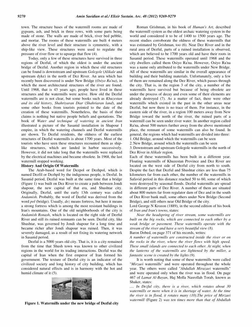
Today, only a few of these structures have survived in three
regions of Dezful, of which the oldest is under the ancient
bridge of Dezful. Another region in which these old structures
can be found is downstream and upstream Golegole (Alikale and
upstream dyke) in the north of Dez River. An area which has
recently been discovered is under New Bridge (Osiyo Ra'na), in
which the most architectural structures of the river are found.
Until 1968, that is 43 years ago, people have lived in these
structures and the watermills were active. How old the Dezful
watermills are is not clear, but some books such as Khuzestan
and its old history, Shahriyaran Diar (Shahriaran land), and
some other books from tourists pointed to the date of the
creation of these watermills. Nonetheless, the basis of their
claims is nothing but native people beliefs and quotations. The
book of Water and technique of watering in ancient Iran
illustrated a picture of the Sasanid installation in Shapour I
empire, in which the watering channels and Dezful watermills
are shown. To Dezful residents, the oldness of the earliest
structures of Dezful watermills is about 1700 years. Most of the
tourists who have seen these structures recounted them as ship-
like structures, which are landed in harbor successively.
However, it did not take long that the watermills were replaced
by the electrical machines and became obsolete. In 1968, the last
watermill stopped working.
History And Origin Of Watermills The Arab-based word for Dezpol or Dezhpol, which is
named Dezfil or Dezhpil by the indigenous people, is Desful. In
Sasanid period, Dezful was built at the same time that a bridge
(Figure 1) was built on Dez River to create a path between Jondi
shapour, the new capital of that era, and Shushtar city.
Originally, Dezful, until the early 13th century was called
Andamish. Probably, the word of Dezful was derived from the
word pol (bridge). Usually, dez means fortress, but here it means
a strong fortress which is among the most resistant buildings in
Iran's mountains. One of the old neighborhoods of the city is
Andamish Ronash, which is located on the right side of Dezful
River and still its ruined remnants can be seen. Dezful city, like
Shushtar, was governed by Jondi shapour for a long time and
became richer after Jondi shapour was ruined. Then, it was
severely damaged, as a result of not fixing its watering network
in Sasanid period.
Dezful is a 5000 years old city. That is, it is a city remained
from the time that Shush town was known to other civilized
regions in the world for its trading interactions. Dezful was the
capital of Iran when the first emperor of Iran formed his
government. The texture of Dezful city is an indicator of the
civilized society and long history of city building, which has
considered natural effects and is in harmony with the hot and
humid climate of it (5).
Figure 1. Watermills under the new bridge of Dezful city
Roman Grishman, in his book of Human's Art, described
the watermill system as the oldest archaic watering system in the
world and considered it to be of 1400 to 1500 years age. The
recent studies corroborate the oldness of these watermills that
was estimated by Grishman, too (6). Near Dez River and in the
rural area of Dezful, parts of a ruined installation is observed,
which are believed to be 1700 years old and have their roots in
Sasanid period. These watermills operated until 1968 and the
city dwellers called them Osiyo Ra'na. However, Osiyo Ra'na
was a name only attributed to the watermills under New Bridge.
All of these watermills are similar in the overall appearance of
building and their building materials. Unfortunately, only a few
of them are remained along the Dez River, which passes through
the city. That is, in the region 3 of the city, a number of the
watermills have survived but because of being obsolete are
under the process of decay and even some of their elements are
already destroyed (7). As a matter of fact, there were other
watermills which existed in the past in the other areas near
Dezful, but now there is no trace of them. For instance, in the
eastern side of the river, in a region 100 meters away from New
Bridge toward the north of the river, the ruined parts of a
watermill can be seen under river water. In another region called
Ra'na, about 500 meters further away from the above mentioned
place, the remnant of some watermills can also be found. In
general, the regions which had watermills are divided into three:
1. Old Bridge, around which the watermills can be seen
2. New Bridge, around which the watermills can be seen
3. Downstream and upstream Golegole watermills in the north of
Dez River in Alikale region.
Each of these watermills has been built in a different year.
Floating watermills of Khuzestan Province and Dez River are
located on the west side of Dezful city from north to south.
Despite the fact that Dezful and Shushtar cities are less than 75
kilometers far from each other, the number of the watermills in
Safavid period in this distance reached 50 to 60, some of which
were destroyed by seasonal floods. Dezful watermills are spread
in different parts of Dez River. A number of them are situated
about 800 meters far from regulator dam of Dez and in the south
of Dez River bank mall, some others under New Bridge (Second
Bridge), and still others near Old Bridge of the city.
Lord George N Krozon (1889), in the second edition of his book
of Iran and Iran's towns, states:
Near the headspring of river stream, some watermills are
built on the big rocks, which are connected to each other by a
weak bridge or pavement. These watermills operate with the
stream of the river and have a very beautiful view (8).
Baron Dobed, on page 371 of his records, writes:
A number of watermills are constructed inside the river or on
the rocks in the river, where the river flows with high speed.
These small islands are connected to each other. At night, when
the lanterns of the watermills are lightened by the miller, a
fantastic scene is created by the lights (9).
It is worth noting that some of these watermills were called
"Mirzaei watermills" and were operated throughout the whole
year. The others were called "Abdullah Mirazaei watermills"
and were operated only when the river was in flood. On page
467 of Lamat Al-Bayan, Haj Molla Nasrollah Torab, known as
Shaker, states:
…. In Dezful city, there is a river, which rotates about 30
watermills or more when it is in shortage of water. At the time
the river is in flood, it rotates many (10).The price of Mirzaei
watermill (Figure 2) was ten times more than that of Abdullah

Amin Saeidian et al./ Elixir Sustain. Arc. 48 (2012) 9269-9279
9271
Mirzaei watermill and both were possessed by a man. One day,
the owner of the watermills sold a Mirzaei watermill in a high
price. He colluded with the writer of the contract and wanted
him to write the word "Abdullah Mirzaei" instead of "Mirzaei".
The writer did so and left a space, as much as a word, before the
word "Mirzaei". Then, the document was signed and sealed by
the seller. The witnesses approved the document. Moezi found
out the cheat and refrain from signing and sealing the
document, but did not express the reason of his refrain. Then,
they add the word "Abdullah" before the word "Mirzaei" and
Moezi signed the document. It is said that, after two or three
years, the cheat was revealed and people became surprised by
finding Moezi's wit and patience. People were astonished that
Moezi did not claim the man to be cheater when that person just
started to cheat (11).
Figure 2. Rent transaction document of mill stone of Dezful
watermills at the time of the Shah of the Qajar period is
known as Sheikhieh watermill which amounted to fifteen
thousand black money was given to the tenant. This
document was equal to eighty Naser-AL-Din Shahi
currency. Source: author.
Sustainable Architecture Of Watermills
Seasons Of Exploiting The Watermills In Dezful, midstream watermills were mostly used in spring
and summer and the watermills of the river bank in winter. In
the seasons which amount of fall was decreased, midstream
watermills were used because the river flow in this type of
watermill was stronger and they operated in both summer and
winter. But, in the seasons that the stream of water was elevated
and midstream watermills went under the river water, the
watermills of the river bank were used. In other words, the
reason of operating midstream watermills was the low level of
river water and the reason of operating river bank watermills
was the high level of river water. Hence, the miller had to
transfer their watermill installation in different seasons (winter
and fall versus spring and summer) to prevent them from
destroying as a result of river spate (20).
Watermill Function The watermills were used to mill turmeric, gypsum, juniper
oil, and sugar, in addition to milling the wheat. These were all
done in almost all the watermills but in these watermills, in
addition to milling, grinding the wheat was also done. To do
this, the miller should increase the distance between the two
millstones. There was a rail, which was raised by a strap,
between two lumbers. The strap and lumbers were positioned
near the millstones. When the millers were taking rest, they raise
the strap to prevent the millstones from rotating. The shaft,
which is connected to the runner stone via the lumbers, holds the
runner stone in a high position(22).
1. Exploiting the potential energy of stream to rotate the
watermill and crush the wheat. Besides, the watermill was
located in the oil-seed extracting and rice factories
2. Welling up water and directing it toward the downstream
lands and gardens with the existing canals
3. Producing hand-made goods in the surrounding areas of
watermills
4. Controlling water volume and its movement by building
sluices with different sluice gates in the path of stream to carry
water to the city and regulate its volume to the amount which is
demanded by the inhabitants.
Different Kinds Of Watermills In Iran And The World Iran's and the world's watermills, which are more than
thousands years old, are divided into three categories (Figure 3),
depending on their types and functional system: Norse
watermill, over-shot wheeled watermill, and floating or under-
shot wheeled watermills (12).
Figure 3 .Watermill designs in order to increase complexity
and efficiency, Norse watermill (left), under-shot wheeled
watermill (center), and over-shot wheeled watermill (right). Source: Reynolds, Terry S.1984. "Medieval Roots of the
Industrial Revolution," Scientific American, July pp.122-130.
Norse Watermill Norse watermills have vertical axis, to which a number of
spoon-like wheel paddles attached (Figure 4). Although some
believe its invention to be done by the Greek, the first time that
about their construction was discussed was for the palace of
Mehrdad, one of the kings of Ashkanid dynasty in Asia Minor
(13). According to Estera, this type of watermill reached China
after third or fourth centuries and, probably, this transmission to
China was done by an Iranian or a Greek in Occident (14). The
name of this type of watermill is attributed to it on the basis of
its operation. That is, this watermill has a vertical channel in its
structure which transfers water from the above level to the
bottom and is called Norse sluice. Water which, with pressure,
exits from the channel outlet hits the wheel paddles. The wheel
paddles rotate the vertical axis, whose end is connected to the
millstone, and the millstone grinds the wheat. Norse and upper-
shot wheeled watermills were used in the regions which had
limited access to water. Generally, these watermills were
designed for the shallow rivers, as they rotate with the fall of
stream water (15).
Figure 4. A sample of the turbine wheel of the Norse
watermill in Iran Source: Edelberg, Lennart and Schuyler Jones, 1979, Nuristan,
Akademische Druck- u. Verlagsanstalt, Graz, Austria.
Over-Shot Wheeled Watermill An over-shot wheeled watermill has a horizontal axis,
which turns to vertical axis by the gearbox. It is believed that it
was invented by Romans in the first century BC (Figure 5) and

Amin Saeidian et al./ Elixir Sustain. Arc. 48 (2012) 9269-9279
9272
was introduced to the world by Metroderus, an Iranian traveller,
in fourth century AC (16).
Figure 5. Montell Seely’s Waterwheel in Castledale, Utah
(2002) (right) and the details of operation (left) Source: Gies, Frances and Joseph, 1994. Cathedral, Forge, and
Waterwheel: Technology and Invention in the Middle Ages,
Harper Perennial, New York.
Floating Or Under-Shot Wheeled Watermill The difference between under-shot and over-shot wheeled
watermills lies in the system of wheel movement or the wheel
paddles and in the place of positioning the wheel. That is, over-
shot wheeled watermills were usually built near the river (Figure
6) to be moved by river stream or they were moved by flume
water, which fell on the wheel paddles. But floating watermill
(as its name suggests) was built in the mid-stream and water
moved under its paddles and hit them so that they rotate. Then,
the produced energy of the paddles was, by two gearboxes,
transmitted to the vertical axis via a horizontal axis. The
movement of the vertical axis caused the rotation of the
millstone and grinding the wheat. According to Procopius, the
wheels of these mills were first developed by a Roman general
in 574 (11a). However, nowhere but Dezful is reported to use
this type of watermill. Floating watermills were built in flat
regions with abundance water. In other words, not all the
regions with river could build such watermills. They were
designed in a way that they were resistant against the forceful
and repeated beats of water flow and even against flood. Thus,
the number of these watermills is very scarce and Khuzestan
Province is the only place we can see such structures. These
mills are designed in a ship-like form so that they can resist
against the tides (17).
Figure 6. the details of operation of the under-shot wheeled
watermill. Source: Gies, Frances and Joseph, 1994. Cathedral, Forge, and
Waterwheel: Technology and Invention in the Middle Ages,
Harper Perennial, New York.
Architecture And Typology Of The Dezful Watermill Dezful watermills are built in two floors (Figure 7), of
which the first floor was the place for the installation and the
second floor was the place for grinding the wheat. The border
between the two rooms was a roof, made of wood and covered
by thatch. The design of the wall was in a form that wooden
lumbers, with 10 to 15 centimeters width and 200 centimeters
length, were put in the wall from the two ends to 20 centimeters
deep in the wall. Then, it was covered by cane and the canes
were covered by thatch and cane leaf. At the end, they were all
incrusted by a layer of mortar or lime (Figure 8). The mortar
was troweled so that it becomes smooth and uniform on surface.
After drying the mortar, a smooth and nonporous surface was
produced for the wheat to be collected on.
Source: author
The wall façade, which formed the outer face of the
structure, was made of brick, whose inside was filled with a
mixture of mortar and bed river pebble which were abundantly
available on the bed of the river. Sometimes, the outer façade
was built with a blend of pebble and brick. This type of building
administration was adopted from the style of Sasanid bridge
construction in Dezful, which its remnants are visible under
Dezful Bridge.
Figure 8. Detailed presentation of the wooden roof of the
watermills Source: author
Dezful watermills were designed in two forms: doublet (or
single) watermill and pair watermills (Figure 9). Single
watermills were the mills which had only one millstone to
operate. That is, they had one single room, called single-stone.
Pair watermills were the mills which had two rooms and were
also called two-stone. The two rooms were separated from each
other by a blade of brick wall. The general aspects of all of these
watermills are the same, a two-floor structure with a ship-like
nose (Figure 10).
All the watermills were connected to each other as well as
the river bank by some bridges. With these bridges, people
could carry their wheat, barley, or other grains by horse or other
cattle to exchange with flour. The point is that the cattle were
stopped near the dykes and, for the rest of the way, the packs of
grains were carried by the workers, because the dyke paths were
narrow and the cattle could not turn around on them (18). Dezful
watermills were all constructed on the bed of Dez River, which
has a conglomerate structure. The hydraulically powered
structure on the Dez river bed is considered among the firmest
conglomerate structure, which in rigidity is similar to concrete.
Figure 9. Dezful watermills were designed in two forms:
single (right) or pair watermills (left). Source: author

Amin Saeidian et al./ Elixir Sustain. Arc. 48 (2012) 9269-9279
9273
Figure 10. Facade of wave breaker (surfing) nose of Dezful
watermills; the watermills of Dezful had a boat-like nose to
resist against the formidable tide of Dez River. Source: author
Building Materials The materials, which were used in the structure of the
watermills, should be very resistant against humidity and,
therefore, were mostly river bed pebbles, brick, mortar and
wood. The basis of the structure of these watermills is made of
thatch, ash, and brick. The bricks are arranged in three rows and,
in some parts, the basis is made of one row of stone. The walls
of the structure are made of brick, river bed pebbles, and mortar.
The brick sizes are about 7×24×24, 4×18×18, and 3×20×20
centimeters and their colors are yellow and red. The Soil of the
brick was supplied from the mines around Dezful city and, then,
was baked (Figure 12). The method of constructing Dezful watermills was called
Sak. In this method, to construct the wall, all around it was
casted by building materials such as brick and mortar. Then,
inside the area which was surrounded by brick and mortar,
mortar was casted. At the same time river bed pebbles in a non-
cast form (or floating) were thrown in it. As a result, the speed
of administration of work picked up and a structure similar to
the conglomerate structure of the river bed was formed (19).
Figure 11. A detailed depiction of the Dezful watermill
Source: author
The outer crust of the walls and Dezful watermills, as was
mentioned before, is usually made of brick, but in some parts a
mixture of river bed pebble and brick was used. This unique
style of wall building is derived from architecture of Sasanid
period. The bases of this watermill-bridge, which are built in
Sasanid style, can still be observed (Figure 11). To fill the
curved parts of the structure, the pieces of crushed bricks were
used rather than river bed pebble. This was specifically done to
create a new style on the curved lines. All the watermills are in
harmony in respect to their structure, construction, and
appearance and they follow a certain type of architecture.
Figure 12. A profile of Sasanid bridge structure, which was
used in constructing Dezful watermills in Dezful Source: author
Water Mills Operation
Ground Floor When water hits the nose of the watermill, it is redirected to
the sluice gate. To control the entrance of water to the sluice, a
lumber is placed on the sluice, which supplies water (Figure 13).
Figure 13. View of the watermill sluice gate (right), the plan
sluice gate of watermill (center), profile of the watermill
sluice gate (left) Source: author.
When water enters the sluice, it is directed to the narrower
side of the sluice and its pressure increases. With the slope that
is created in the sluice, the water pressure still goes up more in
its way to reach the wheel (Figure 14).
Figure 14. Depiction of increase of water pressure as well as
the proportion of the wheel and sloped surface Source: author.
When water hits the wheel paddles, the paddles rotate and
the rotation energy is transmitted to the wooden axis (shaft) and
thence gorgor and from there to duleh. Duleh transmits this
energy to the vertical axis (upright shaft). Since the force is
transmitted from bedstone and upright shaft passes through both
bedstone and runner stone, it rotates the runner stone and, as a
result, flour is produced by the rub of the two stones on each
other (Figure 15).
All the above mentioned installation was made of wood.
The point is that in fastening different elements of watermill no
metal nail was used. Only, in some parts of shaft head in roller
bearing, steel was used to decrease the friction and increase
rigidity. As long as the installation was directly in contact with
water, old methods and tricks were applied to fasten the
elements together and make them firm. To strengthen the gorgor
cogs, for instance, the same method applied to ax head was
used. That is, before fitting the cogs on the rim of the gorgor,
the cogs were covered by cloth. When the wood and cloth came
into contact with water, they swell and their volumes doubled.
Thus, despite water exerts pressure to the cogs, the cogs did not
dislocate. In addition, in places such as the gorgor cogs, which
should bear much pressure and friction, pear tree wood was
used. Pear wood is a very resistant wood against water erosion.
Figure 15. A profile of the watermill and the connection of
the installation and gorgor room Source: author

Amin Saeidian et al./ Elixir Sustain. Arc. 48 (2012) 9269-9279
9274
Inside the installation rooms, a reservoir-like space is
contrived, in which water was probably collected so that the
gorgor was in water at the time of its rotation. Water of gorgor
reservoir was supplied by a branch of the sluice. In some
watermills, another channel, in addition to the sluice, was built
to take out additional water (Figure 16).
Figure 16. The rooms which redirect water to the watermills Source: author
Making provision for the damage, done by river flood in fall
seasons and entrance of water into installation room, a corridor
was built in most of the installation rooms so that it could carry
the flood water out of the rooms and prevent the installation
from decaying. The bottom of the watermill sluice was covered
by pavement to decrease the wear and tear of the sluice bottom
and walls. With regard to the rise in the speed of water in sluice
and movement of water on the sloping surface, it is necessary
that water flow calms down in the sluice end to prevent the flow
from damaging to the walls. To this end, in the space after the
paddle wheel, the width of the sluice is increased gradually and,
as a result, the water flow speed decreases. However, despite
decreasing the speed of water flow, some of the elements such
as gate are eroded. This is the result of flow of sluice water in
the times of increasing the width of sluice. The space of lower
floor is more than the upper and about 60 percent of it is
occupied with the installation. The reason of filling the lower
floor with more installation was to make the structure basis
heavy, for the purpose of adding to the resistant of the building
against the water pressure.
Upper Floor The distance between the upper rooms and the river bed is
about 4 meters and the upper rooms are built symmetrically. The
watermills are built with a ship-like view (Figure 17). This style
of architecture was used to decrease or increase water pressure.
The upper floor, which is called watermill room, has 30 to 40
centimeters thick walls and is much lighter than the lower floor.
The nose of the structure is thick, as it should tolerate the water
flow pressure at the time of breaking the tides. As was
mentioned before, lower floor was made of wooden timbers,
cane, and thatch as well as mortar. The roof of the upper floor is
made of mortar and brick in a cross-sectional form. It worth
noting that to decrease pressure on the gorgor and duleh, the
runner stone was built lighter than the bedstone so that it could
rotate with little force.
Figure 17. The outer view of the ship foundation which is
caulked with gypsum and mortar and filled with mortar Source: author
The Function Of Watermills As Bridge In Dezful Dezful watermills are located on a sedimentary and
conglomerate bed of the river (12) and are extended on the
width of the river successively (Figure 18). Today, the remnants
of the watermills can be seen under New Bridge. The
arrangement of the watermills was in a way that they act like a
dam to direct the river flow to a certain direction. This structure
was a Sasanid developed one, which made a cut on the first part
of the river and was called dyke.
Figure 18. Bridge, Dezful watermills were extended on the
width of the river successively.
Source: author. In some cases, the connection path of old watermills turns
to be a part of that of new structures on the river (the example of
such phenomena is seen under the New Bridge of Dezful). By
considering the seasonal operation of beside and inside river
watermills as well as the extension of watermills to New Bridge
and the status of the ruined part of the midstream watermills, we
arrived at the conclusion that one of the main reasons of
building such watermills was to create a path between the two
banks of the river, specifically in the current locus of New
Bridge. Regarding the fact that one of the main connection path
between resident area and the existing watermills were founded
alongside of New Bridge (Figure 19), the above mentioned
probability increases. The creation of a raw of bridge-like
watermills along New Bridge indicates that accounting the
constructed watermills a connective path is sensible (13).
Figure 19. Bridge-watermill of Dezful, spread over the river
width successively Source: author.
Using the set of watermills as a bridge in the area of New
Bridge because of the absence of bridge is also another proof for
the above mentioned claim. By considering the point that the
resident area and watermills of the town were beside the river, it
can be said that the suitable path to access different areas and
watermills was the surrounding area of New Bridge and Old
Bridge. As there was no asphalt route, the watermills were
constructed with mortar and river bed pebbles in the form of a
narrow path alongside of the river in a way that the path was 1
to 1.5 meters above the ground level. This path became a track
for the pass of the cattle and it ended in the river side. Keeping
in mind the difference between the levels of river side and
resident area, the main way to access this path was created via
various sloping paths and stairways. Taking account of the old
texture of the city, we can hypothesize that there was no main
and always-used road and there were lots of access paths to the
river side through the avenues and tracks of the old texture of
the city (Figure 20).

Amin Saeidian et al./ Elixir Sustain. Arc. 48 (2012) 9269-9279
9275
Figure 20. Watermill plans under Old Bridge.
Source: author
Method of Construction Most of the watermills in Iran are of Norse type. However, there
are some over-shot wheeled watermills and Dezful's watermills
are of floating (or under-shot wheeled) type. Dezful's watermills
are composed of the following parts:
1. Steel shaft
2. Wooden horizontal shaft
3. Wheel paddle
4. Gorgor
5. Gorgor cogs
6. Roller bearing
7. Dule
8. Upright shaft
9. bedstone
10. runner stone
Water enters the reservoir, in which wheel paddles and gorgor
as well as other elements are located, via the sluice gate. Note
that the place where the wheel is stored is called slope and
where gorgor is kept is called reservoir. Water level should be
about 70 to 80 meters (with the volume of 220 cubic meters) so
that water can move the wheel (Figure 21).
Figure 21. Details of the mechanical system of watermill
Source: author.
Watermill Wheel The wheel is positioned in the opening of the reservoir,
which is called slope. Water, when passes the sluice, hits the
wheel with high pressure. As a result, it moves the wheel and,
then, enters the reservoir. The movement of the wheel causes the
rotation of other elements of the watermill. The wheel is made
of lotus wood and has 16 paddles, which are pinned to each
other by katal as well as ashkan, and are arranged in three rows.
The length and width of the paddles is usually 90 and 80
centimeters. In the middle of the wheel, a horizontal shaft which
is usually made of lotus or berry wood and is 45 centimeters
thick is fixed up. The wood should be supplied from a lotus tree
which is at least 80 to 90 years and 60 to 70 centimeters thick.
The rationale for using lotus wood for the wheel and other
elements of the watermill is its oldness and nativeness. The
watermill wheel is built in a way that its surface area is
changeable in size. That is, in summer (or at the time of water
shortage), the vacant distance between the paddles is filled by
another paddle. Depending on the wheel speed and water
pressure, the vacant space between every other paddle or every
two paddles is filled with some additional paddles so that the
paddle surface area increases. As a result, the wheel is rotated
with higher speed by the pressure of the water. When the water
pressure was high, the additional paddles were not used. When
the water pressure exceeded the allowable limit, two or three
lumbers were placed in opening of the reservoir (or the slope) so
that the pressure decreased and prevented the paddles to be
damaged. Usually, the paddle surface area of the watermills
inside Dezful city was less than that of outside the city, as the
later included the paddle surface area of flutes Norse watermills.
This was because water pressure for the watermills outside the
city, which operated with the flute or well water, was very low.
The surface area of the paddles of Dezful watermills was two
palms but for that of outside the city was four palms. Hence,
when the discharge of water decreased, the surface area of the
paddle, by increasing the number of paddles, was increased so
that the wheel could rotate with higher speed and could mill
more wheat (Figure 22, 23).
Figure 22. Detail of connection between main components of
watermill, a profil of the instalation. Source: author
Figure 23. Façade of the wheel
Source: author.
GORGOR Following the movement of the wheel, gorgor (Figure 21,
22) is moved by the rotation energy provided by the horizontal
shaft, which is common between the wheel and gorgor. Gorgor
is a type of wheel divided into four parts with 36 cogs on it. On
each part, there are 9 cogs, which are made of apricot tree wood.
All the four parts are connected, by four supports, to the
horizontal shaft. To make the structure firmer, two wedges,
which are connected to the horizontal shaft, are located on two
sides of the supports. The diameter of each gorgor is 2.5 to 1.30
meters. The other side of gorgor is also cogged and a strip of
wood, which was called Pajar, was inserted in between the
cogs. Pajar is about 5 to 6 centimeters plank, which adds to the
firmness of the cogs. On gorgor, a number of arches are located
to strengthen its resistance.
When the wheel rotates by the water pressure and gorogr
starts moving, the gorgor cogs (Figure 24) hit the dule rods and
moves them. The reason why gorgor cogs (Figure 25) are made
of apricot tree wood is that apricot wood, when is rubbed against
any surface, spatters oil. That is, when the gorgor cogs which

Amin Saeidian et al./ Elixir Sustain. Arc. 48 (2012) 9269-9279
9276
are made of apricot wood are rubbed against dule rods, they
spatter oil. By the pass of time, not only the movement is not
slowed down but also it becomes faster to hit the dule and rotate
it.
Figure 24.THE PROFILE OF GORGOR COG
Source: author. Dule
Dule (Figure 21, 22) and its rods are made of wood. Each
watermill system has a spare dule, as dule is broken after
working for one or two weeks. Dule had six rods and a
cylindrical spindle, which is called upright shaft, passes through
it. One end of the upright shaft is connected to the bedstone and
moves it and another end of it is connected to a prop and prop is
attached to pushin and roller bearing.
In the place that upright shaft of dule is attached to pushin
and roller bearing, or in other words on the top and bottom of
prop, two wedges are placed. When coarser flour was intended
to be used, a wedge was set on the top of the roller bearing or
the same two wedges were hammered. They were hammered to
raise the dule and to distance the bedstone from runner stone
and, as a result, produce coarser flour. But if producing some
finer flour was intended, the wedges below the roller bearing
were lowered down so that the bedstone took nearer to the
runner stone and, as a result, finer flour was produced. The
miller should go to the lower floor to raise or move down the
wedge and fix it.
The system of these watermills was used in different works
and in various forms, from among which the primary models of
transferring water system (such as gavgard and shotor galu) can
be pointed out as a primary model and mechanical gearbox in
the industrial machines as a modern model.
Millstone
Bearing in mind that big and firm stones were scarcely
found in the region, people had to arrange small pieces of big
stones near each other to build the millstone and put a metal belt
around them. Then, the belt was fastened with two bolts.
Another way to make a millstone was that a strap was filled with
stone and mortar and, then, the surface of inside stones was
rubbed so that they turned to a smooth and uniformed millstone.
With one turn of the water wheel, the millstone rotates for six
times. The millstones were two stones, one on the other in an
ardoun (a place where the flour, the result of milling the wheat,
was poured firstly). The bedstone is fixed and covered by lime
and clay. It is moved by an upright shaft, which was connected
to the dule. The ardoun on which the stone is placed was made
of wood, whose pores were filled with stone and lime. To
prepare the millstone, a monolithic stone or some pieces of
stones were circumscribed by an arch to make it firm. A hole
was dug in the middle of the runner stone to take the wheat to
the space between the two stones. The result of rubbing the two
stones was the production of flour.
Wheat container and its board Seven centimeters above the stone, there is a wheat
container and its board. The board is located on a support, which
is called gachshen and surrounds the stones in a semi-circle
shape. First, the wheat is poured in the wheat container. The
wheat container has a hole, from which the wheat passes and is
directed toward hopper and, thence, to an eye. The eye is
connected to the wheat container board by a cord. From the eye,
the wheat pours into the stone hole. With the rotation of the
stone, the wheat is ground to the flour. To regulate the wheat
entrance to the stone hole, the shoe, which is connected to the
cord, increased or decreased the eye slope. In this way, the
amount of wheat which enters the eye is regulated. In dry
seasons, some temporary dykes were built with a number of big
wooden wheat containers, called Chusala. Then, they were filled
with stones so that they could stop the flow of water and direct it
to the watermills. When the river flow was decreased in the river
bed, a sluice was created to direct river water into the river bed
so that more water could flow in the watermills.
To heighten water level of the river, some wooden-made
dykes, branches of the trees, or stone-made and basket-like
dykes were put, like a wall, in sluice gate. Also, a conduit was
extended from inside the river to upstream so that the river flow
was deviated toward the watermills. Then, the dykes (or wheat
containers) were filled with river bed pebble and fitted in a
specific place. Every year, these temporary deviator dykes were
ruined by the flood and the next year were built again in the
seasons with water shortage. In fact, the wheat container was
composed of three or four lumbers (with about two meters
length), which were fastened together and filled with river bed
pebbles so that it became heavy and went down on the river bed.
Wheat container wood was usually obtained from lotus trees, as
this type of tree is one of the oldest and native ones in
Khuzestan. In winter, the inside watermills went down under
river water and the miller had to leave these watermills and go
to the river side watermills. Except for the wheel and gorgor, the
miller carries other light tools of the watermills with him to the
river side watermills and, then, he started to work in the new
mills. In winter or any time that the inside river watermills were
not operated, three lumbers were mounted vertically on a
horizontal board, to act as a watermill sluice gate, so that the
reservoir opening was closed. Sometimes, matting was used
instead of those three lumbers and it did what the lumber could
do. Despite all these facilities, sometimes the water flow broke
the lumbers and damaged the wheel severely. That is, when
level of river water raised and the watermills were not operated,
the wheel and gorgor were, by a string of rope, lifted to 70 to 80
centimeters above ground so that they could stay away from the
water pressure and being damaged. However, this practice was
not commonly applied to the wheel and gorgor. In past, to raise
the water level and redirect it toward the watermills in the dry
seasons, some matting baskets were put on each other. These
baskets were filled with stones and formed a deviator dyke,
called chusale.
Example of watermill
Ra'na watermill Next to Golegole watermills and near the place that is today
called concrete New Bridge in Dezful, a row of numerous
Roman arches as well as stone and mortar walls with 1.30 to
1.70 meters thickness, small and big mouths, and half-ruined
rooms is observed. They are built in the river width and a wall
with 150 meters circumference is built round the north side of

Amin Saeidian et al./ Elixir Sustain. Arc. 48 (2012) 9269-9279
9277
the river. This wall is attached to another wall with 15 small
bridges inside from the left end and is dived into four separate
parts from the right end. These four parts are 3 meters far from
each other. The north view of the foundation is like a ship prow
and some rooms and sluice gates can be seen on it. Each room
has two sluices, each connected to a hole, with narrow and wide
parts in its inside.
The outer view of the foundation is caulked with gypsum
and mortar and filled with mortar. Some holes and stairways are
seen on it. The rooms are four meters above the river bed and
some divisions in the form of stairway and symmetric vertical
and horizontal holes can be seen in them. It indicates that these
four parts and two other parts, which were connected to that
four, are completely destroyed on one side of the whole
structure. The same layout is built on the other side of the
structure and occupied the width of the river. This type of
structure building was transmitted to China in fourth century AD
and the transmission seems to be done by Iranians or Greeks in
Occident.
From the remnants of the ruined foundation and walls, it
seems that the old installation, reservoirs, and sluices were used
to upraise the water level, control water pressure, regulate the
volume of needed water, directing water to the east or west side
of the river, and water the farms. In the middle of the two arms
(two sides of the structure), some parts of thick and arched
dykes are remained. At the back of these two arms and next to a
circumscribed area that is similar to a big pool and occupies
about 35 meters of the width of the river, a big lake is formed. In
the north side of the river, this lake categorized the river into
four sections. In each section, a big pool is built and water pours
into the pool from each section, which had six openings. In each
arm 24 openings and, thus, in the two arms 48 openings were
built. Therefore, there were 64 openings to direct water to the
pools of north and south sides of the installation. At the back of
the north side of the structure, three separate parts of the rooms
are partly destroyed, which are like those found in the upstream
of the river. The roof of these three rooms, which are like the
ship roof, can be yet seen. From inside the rooms to the river
bed, there are remnants of the structures of controlling water and
the gates, which are like those found in the upstream of the
river.
Different parts of the north and south dykes, which
circumscribe the middle reservoir, are arranged in a way that the
rejuvenated water flow can easily pass different surfaces and
enter the sluices without any damage to the set-back and
indentations of the sluice and without changing the angle. Then,
it can simply contact with the body of south dyke and get out of
there. Therefore, from the frequent and calculated angle
changing, which is made in the path of water entrance to and
exit from the sluice gate, we came to a conclusion that the
pressure and volume of water were calculated by and were
known to the builder of these structures and, in this way, the
walls and dykes were protected against damaging. In the middle
of north side, which is on the gate, a giant structure is remained
which is curved and porch-like with Sasanid style.
Remembering that these structures are located in the middle of
the river and next to a lake, the Sasanid emperors were
interested in the places near rivers and lakes to dwell, and some
of them were buried near such places, and they carved their
images on the stones near lake, we might say that these
remained structures near lake are left from a small palace where
an emperor stayed for a while or passed a few time in. In fact, it
seems that on the middle of this watermill wide surface, which
has view to north and south and has no path to be accessed but
the dyke, there was a palace in which a general or a member of
royal family lived. On the east and west sides of this giant
structure and to about 400 meters away, which is next to Metal
Bridge of Dezful, some old buildings can be seen. It seems that
the function of these buildings were to stop the sudden fall in the
height of water level and its flow out of pool. A number of
devices were built on this part so that the deep pool and its warm
water flow can be a place for jaunting and amusing, shipping,
etc.
The water level in this pool came up in a way that building
another set of installation to divide water path branches and to
direct the conduits in order to control water pressure and volume
in about seven hundred meters away from the south of that
structure was deemed necessary. Therefore, such installation
was built and its remnants from that era can be observed in the
neighborhood of Metal Bridge of Dezful. Foundation and some
parts of openings which are built on Ra'na watermills indicate
that a bridge was built for people to pass and there were some
guards who had houses to live in these sections of the watermill.
The ruined remnants of this structure are seen on the east, near
Metal Bridge.
From the whole system, with all its innovations in pressure
breaking, opening, dam crowns, arches, rooms, dykes, and
diagonal lines for inhibiting the tidal flow, some ruined parts are
remained which occupies the width of the river. It has some
conduits, which branched from east and west of the river to
water Dezful city and the farms all around the city. Doubtless,
milling the wheat was not the only usage of watermills. In fact,
the set of watermills act like a dyke, which by the pass of time
has been decayed. Over time, new watermills were built on the
ruined parts of the old watermills. In other words, the
foundation, walls, holes, and sluices of the ruined watermills
were used for the new watermills. By investigating the
watermills which were built by men and the repairs which were
made on them, we might say that the last repairs were made on
Safavid period. The reason for claiming this point is that the size
of the watermill bricks is the same size of brick which was used
in Safivid period, 18.5×18.5×3.5 centimeters.
Figure 25. Ra'na watermills.
Source: author.
Koli watermills Today, Ali Koli brook, on which the watermills were built,
is dry. Interior buildings of the structure of watermill indicate
the elegancy and delicacy in their construction, room designing,
and earrings-like style of the structure. There is no building or
wall surrounding the structure. The sizes of structure bricks,
which are very old, are 17×17×3.5 centimeters. In some parts of
the structure, ionized bricks are used. Interior parts and rooms
include two or three floors, which are made of adobe and are
covered by thatch and the whole structure is 6.10 meters wide
and 13.7 meters long. There is a sluice, made of brick and
mortar, in northwest of the structure.
Golagole watermills of upstream and downstream, located
in the north of the upstream river (called Alikale), are the oldest
watermills of the city. The bases of these watermills are made of

Amin Saeidian et al./ Elixir Sustain. Arc. 48 (2012) 9269-9279
9278
the arrangement of gypsum, ash, and three rows of brick, while
some parts of it are made of stones. The walls are made of river
bed pebbles and brick and, in some places, mortar.
Abas Abad watermills This brick-made and rectangular-form structure is
constructed in a good and organized style. Inside the structure, a
building is made of clay and adobe, from which some parts of
arches, rooms, and walls are remained. On the west side of the
structure, a tableau of brick and mortar is built that direct water
into the watermill. The bigness of the structure and its organized
façade as well as its uniformity are the signs of a great culture.
Such an excellent cultural heritage is a prerequisite for building
any unique structure. These structures, with 15×9 meters width
and length, satisfied one of the daily demands of the people of
that era. On the east side of the structure, there is a brick baking
forge, with a curved arch made of brick and adobe, which has
some similarities with the ruined watermill. It may be stated that
the forge was exclusively established to bake the brick, which
was necessary to build the watermill.
Shams Abad watermills This watermill is made of brick, like Ali Koli and Abbas
Abad. It has two or three floors, some rooms, and a tableau of
water is on the west side of the structure. On this watermill,
some repairs, with brick and clay, are made. Most part of
bricking of the outer view of the structure is now destroyed. The
sizes of the old bricks on the south view are 30×30×6.5
centimeters and those of the new bricks are 17×17×2.5
centimeters. The older brick are red and yellowish white, like
the famous khotaei bricks. On the south side of the structure, an
arcade sluice is constructed to pass additional water. The arch
curvedness was less convex and more concaved, in comparison
with Ali Koli and Abbas Abad watermills. The outside
dimensions of the structure are 16×7 meters.
Conclusion Theory 1: these mills were built with the purpose of milling
from about 1700 years ago, but with the pass of time they broke
down. Some of them were reconstructed and some other left
untouched until 1968 and became completely idle.
Theory 2: the structures that we call watermill did not function
as watermill from the beginning. From the archaeological point
of view, when they were exploited at about 1400 to 1500 years
ago, they were not only dykes which connected the two sides of
the river but also regulator dams that could impound water to be
later used to water the farms. However, as their structures were
suitable to mill, the theory of using them as the mills cannot be
easily rejected. In archaeologists’ ideas, these structures were
rebuilt in Safavid period and operated as watermill. In other
words, they were gigantic dykes which, after making a few
changes, turned to mills. Over time, some changes were made
on them by the floods and other environmental factors. Their
last changes are considered to be made in Safavid period, with
the evolution of brick. At that time, the dimensions of their
bricks turned to be 18.5×18.5×3.5 centimeters.
These sets of installation, with their complex and well-
aimed design, breakwater, large walls, openings, and
depressurizing tools, were constructed on the river and took
river water to the surrounding pastures and farms. They could
not be some simple mills, which only milled the wheat. It might
be discussed that they were the structures with some special
purposes whose functions were changed to milling. We might
even claim that, a few years later, the mills were built on the
foundation of these structures.
Regarding the two theories and according to the conducted
studies, we might discuss about the multipurpose design of this
installation. That is, this set of installation was used to both
direct the river and function as a dyke and mill, in Sasanid
period. Additionally, it was used a as playground and stay place
for Sasanid commanders, as the number of milldams and the
pressure of the river flow could be controlled and people could
swim or boat in the river. On the other hand, two capitals of the
Sasanid dynasty were Fars and Tisfoun. The link between these
two capitals was established through Kohgiluye, Bakhtiari,
Ranhiroz, Shoushtar, and Dezful towns, Karkhe River, and most
probably Dezful dyke. It might be claimed that the whole set
was a dyke, which was built with much care and delicacy to
increase the level of water behind the dyke, help the pass of the
missions, water the farms, and serve as a stay and entertaining
place for the commanders. In other words, it was a military path,
which was also used as a place for taking rest and relaxing. We
can even say that the whole set and the rotation of the mill
wheels was a part of facilities for the Sasanid troops. In the
openings, there are traces of a magnificent arch. Remembering
the Sasanid kings’ interests in this type of structure, we
conjecture that it was a living place for a commander or a great
man of that era.
Dispensed with the function of such structure, about which
the technology of building by people of that time with that
limited knowledge is questionable, what is significant is great
resistance of these watermills against the flow of one of the
biggest rivers in the country. To sum up, it is evident that this
structure, dating back to 1400 years ago, is still firm. Its
imperishability can be attributed to the engineering powerful
theories of the builders of that era. They used nose-like
structures in front of the whole structure so that it can act like a
ship prow to cut water flow and prevent it from destroying the
structure. The other cogitative technique was the use of mortar,
as one of the toughest building material, to build the structure.
Also, mortar, in comparison with concrete, could better increase
the resistance of these structures against water flow.
References 1. Nakhjavani. 1976. Sahah Al faras . Tehran: Fars word. Asadi.
112 pp.
2. Esfahani, Mohammad Hafiz. 1972. Three treatises on
industrial inventions. Tehran: Iranian Cultural Foundation
Publishing. 112 pp.
3. Dezfuli Afshar, Iraj. 1991. Khuzestan . Tehran: Crystal
Publishing.
4. Dezfuli Afshar, Iraj. 1995. Khuzestan and its primitive
civilization . Tehran: Ministry of Culture and Islamic Guidance
5. Dezfuli Afshar, Iraj. 2000. Research in the name of the
Iranian cities . Tehran: Rozaneh
6. Eghtedari, Ahmad. 1995. Diar e shahriaran . Tehran:
Association of National Heritage
7. Eghtedari, Ahmad. 1981. Khuzestan, Kohkiloieh va mameseni
. Tehran: Association of National Heritage
8. Rawlinson, Henry. 2000. Rawlinson Itinerary . Tehran:
Rozaneh.
9. Baron, David. 1993. Lorestan and Khuzestan Itinerary .
Tehran: scientific and cultural enterprises affiliated to the
Ministry of Culture and Higher Education.
10. Imam, Mohamad ali. 1995. Dezful historical proverbs .
Dezful: Dez Publishing.

Amin Saeidian et al./ Elixir Sustain. Arc. 48 (2012) 9269-9279
9279
11. Imam, Mohamad ali. 1995. Scholars and clergy of Dezful .
Dezful : Dez Publishing.
12. Enayat, Cyrus Reza. 1975. Water and irrigation technology
in ancient Iran . Tehran: Ministry of Culture and Higher
Education
13. Farshad, M. 1984. Engineering history in Iran . Tehran:
Goiesh Publication
14. Beazley, E. 1963. Greek mills in Shetland . The architectural
review, CXXXIV
15. Hyde, R., 2000. Climatic Responsive Design, New York: E
& FN SPON publications.
16. Mirdanesh M, 2007. Acquaintance with historical
monuments, Tehran: published by Madrese Co.
17. Cultural research association, 2007. The Iranian Atlas of
Vernacular Architecture, published by Cultural research
association.
18. Poor Ali, Hasan. 1996. Dezful . Tehran: Afrooz.
19. Iranologist group of scholars from Europe. 1976. The history
of civilization in Iran . Tehran: Mohebi.
20. Shooshtari imam, M. A. 1966. History and geography of
Khuzestan . Tehran: kalameh.
21. Kiani, M. Y. 2006. Iranian Architecture; Islamic Period .
Tehran: published by Samt Co.
22. Sani-o-doleh, A. 1948. Travel account of sani-o-doleh bal-
ami, Tehran: Published by Khesht-e-Aval Co.
23. Reynolds, Terry S.1984. "Medieval Roots of the Industrial
Revolution," Scientific American, July pp.122-130.
24. Edelberg, Lennart and Schuyler Jones, 1979, Nuristan,
Akademische Druck- u. Verlagsanstalt, Graz, Austria.
25. Gies, Frances and Joseph, 1994. Cathedral, Forge, and
Waterwheel: Technology and Invention in the Middle Ages,
Harper Perennial, New York.