521262 - propertyfile.gov.bc.ca
TRANSCRIPT

521262
B R I N C O M I N I N G L I M I T E D
FINAL REPORT ON THE HART LAKE PROJECT NANA1MO AND ALBERNI MINING DIVISIONS
BRITISH COLUMBIA NTS 92 L/4, 5
BY R. A. GONZALEZ, M.Sc, F.G.A.C., P.ENG.
ARCHEAN ENGINEERING LIMITED NOVEMBER, 1984

FINAL REPORT ON THE HART LAKE PROJECT NANAIMO AND ALBERNI MINING DIVISIONS
BRITISH COLUMBIA NTS 92 L/4, 5
SUMMARY
In late 1984, BRINCO MINING LIMITED completed a geological, geochemical, geophysical, and diamond d r i l l evaluation of the precious and base metal occurrence on the Iron Cop Showing and a geological appraisal on the surrounding Hart Lake Property. Results of this investigation confirm the presence of gold and copper, at the Iron Cop Showing, in narrow, f i s s u r e - f i l l i n g , and probably structurally controlled zones. Six of seven diamond d r i l l holes were designed to test the downward extension of surface outcrops; this work phase indicates that the high grade samples known from surface showings do not continue at depth. The seventh d r i l l hole, allocated to test a geochemically anomalous area, penetrated 62 metres of alternating bedded limestone and thin inter-bedded layers of highly altered basic volcanics before bottoming in weakly propylitized basalts. This hole f a i l e d to outline any significant mineralization, and i t i s now believed that the high geochemical response was caused by the metal f i x i n g due to the presence of limestone outcropping in the v i c i n i t y .
Regional evaluation of the generally unexplored Hart Lake Property was also completed. This phase of the programme consisted of geologic and geochemical exploration along with general prospecting in selected areas of the property. Although several areas of intense hydrothermal a c t i v i t y (producing silica-epidote-chlorite alteration with minor pyrite and trace amounts of chalcopyrite) were outlined, lithogeochemical, s o i l geochemical, and heavy mineral concentrate sampling f a i l e d to indicate any potentially metal-rich areas. Consequently the potential for discovering a viable precious metal deposit within the Hart Lake Prospect appears low and no further work is recommended.

i i .
TABLE OP CONTENTS
Page
SUMMARY i TABLE OP CONTENTS i i FIGURES AND TABLES i i i 1. INTRODUCTION 1 ^ r, ? 1.1 LOCATION AND ACCESS 1 *"*"*1.2 PHYSIOGRAPHY AND CLIMATE 3
1.3 MINERAL CLAIMS 3 2/GEOLOGY 6
2.1 REGIONAL AND LOCAL GEOLOGY 6 2.2 METALLOGENIC SETTING 9
3. IRON COP GRID 11 3.1 SOUTHWEST GRID EXTENSION 11 3.2 GEOLOGY 11 3.3 GEOCHEMISTRY 11 3.4 GEOPHYSICS 13
3.4.1 MAGNETOMETER SURVEY 13 3.5 DIAMOND DRILLING 14
3.5.1 DRILL HOLE GEOLOGY 15 4. REGIONAL EXPLORATION 18 5. CONCLUSIONS AND RECOMMENDATIONS 20 6. REFERENCES 21 7. STATEMENT OF PROFESSIONAL QUALIFICATIONS 22 APPENDIX A SOIL SAMPLING ALONG GRID LINES 23 APPENDIX B DIAMOND DRILL RESULTS 27 APPENDIX C REGIONAL GEOCHEMICAL SAMPLING 33
APPENDIX D DIAMOND DRILL LOGS AND SECTIONS 37
1.0 INTRODUCTION
From the end of August to early October, 1984 a f i e l d crew, working out of a camp established on the Iron Cop Grid, conducted regional and follow-up exploration on the Hart Lake Property. Previous investigations on the Iron Cop Grid had: 1) outlined the presence of gold and copper in narrow, structurally controlled zones and 2) indicated significant s o i l geochemical anomalies from areas of l i t t l e geological information. In addition, large areas of the surrounding Hart Lake Property remained unexplored.
•• t - • - ' \ The purpose of this programme was to evaluate the economic potential 6f the Iron Cop Showing and surrounding grid area and to evaluate the -remainder of the unexplored portions of the Hart Lake Property.
1.1 LOCATION AND ACCESS
The Hart Lake Property i s located near Brooks Peninsula on the northwest end —of Vancouver Island. Port A l i c e , the nearest community, is located 13 km to the northeast and Port Hardy, the principal population centre for the north end of the Island, i s 50 km to the north. The claims straddle the height of land between Klaskish River to the northwest and Colonial Creek to the northeast as shown on Topographic Map NTS 92L/4, 5 (Figure 1). Terrestial coordinates for the centre of the claim block are as follows: r
50° 16' North Latitude 127° 41• West Longitude
Access to the property i s currently by helicopter from Port Hardy; the t r i p usually taking approximately 20 minutes. Logging roads from Quatsino Sound extend to within 5 km of the northwestern boundary. A logging road from the southern end of Neroutsos Inlet extends along Colonial Creek to within 2 km of the eastern boundary. Tidewater i s no more than 25 km in v i r t u a l l y any di r e c t i o n . Topography is very steep r i s i n g from 300 metres (1000 feet) along the southwestern corner to over 1060 metres (3500 feet) on Hart Mountain. Primary forest cover i s red cedar, balsum f i r , and western hemlock. Yellow cypress and stunted pine are the dominant species in swamp and transitional areas. Alder i s the main deciduous species and i s abundant in moist sites in areas of second growth and along stream courses. Immature lakes and swamps are sparse and are generally confined to the drainage divide which bissects the property in a northeast direction.


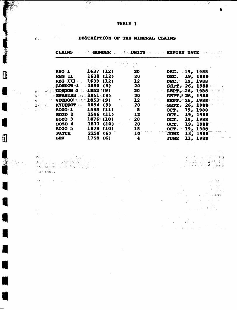
TABLE I
DESCRIPTION OP THE MINERAL CLAIMS
CLAIMS NUMBER A UNITS EXPIRY DATE
REG I 1637 (12) 20 DEC. 19, 1988 REG II 1638 (12) 20 DEC. 19, 1988 REG III 1639 (12) 12 DEC. 19, 1988 LONDON 1 1850 (9) 20 SEPT. 26, 1988 LONDON 2 f 1852 (9) 20 SEPT.^26, 1988 SPANISH 1851 (9) 20 SEPT.' 26, 1988 VOODOOi 1853 (9) 12 SEPT. 26, 1988 KYUQUOT 1854 (9) 20 SEPT. 26, 1988 BOZO 1 1595 (11) 8 OCT. 19, 1988 BOZO 2 1596 (11) 12 OCT. 19, 1988 BOZO 3 1876 (10) 20 OCT. 19, 1988 BOZO 4 1877 (10) 20 OCT. 19, 1988 BOZO 5 1878 (10) 18 OCT. 19, 1988 PATCH 2259 (6) 10 JUNE 13, 1988" BEV 1758 (6) 4 JUNE 13, 1988

6
2.0 GEOLOGY
2.1 REGIONAL AND LOCAL GEOLOGY
Most of Vancouver Island i s underlain by rocks of the Insular Belt, of which the island makes up the greater portion, in the Canadian Cordillera. In recent years the lower part of the Insular Belt stratigraphy, comprising at least the Paleozoic Sicker Group and the Triassic Vancouver Group, has been recognized as part of an allochthonous terrane derived from more southern latitudes (Jones, et a l 1977, Muller 1981, and Jones, et a l 1982). This major allochthonous block has been named Wrangellia by Jones et a l (1977) • Wrangellia, the foundation of Vancouver Island, apparently docked with the North American plate during the Early Jurassic, coincident with the deposition of the volcanic Bonanza Group and contemporaneous Island Intrusions. Terrigenous sediments unconformally overlie the Bonanza Group.
The north end of Vancouver Island i s underlain by rocks of the Vancouver Group, which, as defined by Dawson (1887), include: the Karmutsen Formation, the Quatsino Formation, and the Bonanza Volcanics. Bancroft (1913) and Crickmay (1928) described two additional formations. Parson Bay and Harbledown, as lying between the Quatsino Formation and the Bonanza Volcanics (TABLE I I ) . The Vancouver Group is intruded by rocks of Jurassic and Tertiary age and disconf ormably overlain by Cretaceous and younger sedimentary rocks. The region is further characterized by large-scale block faulting with thousands of metres of displacement. These are often offset by younger st r i k e - s l i p faults with displacements on the order of 1000 metres•
The Hart Lake Property, as shown on G.S.C. Map 1522A, i s underlain by a rather monotonous sequence of dark green basalts belonging to the Triassic Karmutsen Formation; this formation trends northwesterly through the claims and is bounded on the northwest by a northeast trending block fault. The overlying sediments of the Parson Bay Formation forms a narrow band on either side of the Karmutsen Formation suggesting an antiform through the region. Exposed along the eastern and western margins and through the northern half of the property are andesites, rhyodacites, and flow breccias of the Jurassic Bonanza Group. Intruding the sequence and exposed as small plugs on the west, north, and east sides of the claims are post-Bonanza quartz diorite and microdiorite. These plugs are part of the Island Intrusives representing a belt of intermediate intrusives, some hundred of square kilometres in size and common throughout Vancouver Island. In the northwest corner of the property i s a caldera-like feature which has a number of s i l i c i f i e d zones along i t s i n t e r i o r subsidence

7
fault. These zones have been prospected extensively but no significant mineralization, other than single station geochemical anomailes, has been outlined.
A compilation of the geology for the Hart Lake Property i s presented on Figure 3.

8
TABLE II GENERALIZED STRATIGRAPHIC SECTION ACROSS THE NORTH END OF VANCOUVER ISLAND
(modified from Muller, e t . a l (1973)
PERIOD STAGE GROUP OR THICKNESS LITHOLOGY FORMATION (METRES)
CRETACEOUS AND YOUNGER SEDIMENTS AND INTRUSIVES UNCONFORMABLE CONTACT
J U R A
M I ISLAND INTRUSIONS D D L INTRUSIVE CONTACT E
QUARTZDIORITE, GRANODIORITE, QUARTZ MONZONITB, QUARTZ-FELDSPAR PORPHYRY
S s L
VANCOUVER GROUP (GRADATIONAL CONTACTS WITHIN GROUP) I c
0 W tt
BONANZA VOLCANICS 300-5600 ANDESITIC TO RHYODACITIC LAVA, TUFF, AND BRECCIAS
JS R HARBLEDOWN FM. 500 GREYWACKE, ARGILLITE,. TUFF
T R I A s
U P P E
PARSON BAY FM.
QUATSINO FM.
300-600
30-750
CALCAREOUS SILTSTONB, SHALE, GREYWACKE, CONGLOMERATE, AND BRECCIA LIMESTONE
s I c
R KARMUTSEN FM. 3000-6000 BASALTIC LAVA, PILLOW-LAVA, AND BRECCIA WITH MINOR INTERVOLCANIC LIMESTONE
DISCONFORMABLE OR UNCONFORMABLE CONTACT
p E
SICKER GROUP 250 LIMESTONE, SILTSTONE
N N
MIGMATIC COUTAC T N N
WEST COAST COMPLEX (NOT EXPOSED AT HART LAKE]
QUARTZ DIORITB, AGMATITE, AMPHIBOLITE, GNEISS

9
2.2 METALLOGENIC SETTING
Metalliferous deposits at the north end of Vancouver Island are divided into five groups. This i s a modification from the original c l a s s i f i c a t i o n used by Carson (1968) and include:
1) Porphyry Copper Deposits 2) Skarn Deposits 3) Copper Mineralization in Volcanic Rocks 4) Vein Deposits 5) Gold Quartz Veins (Fissure-type)
Porphyry copper deposits are associated with bodies of quartz-feldspar porphyry which intrude the Bonanza Volcanics. A l l known porphyry copper showings are located on the north side of Rupert. Inlet and l i e within a zone of hydro thermally altered Bonanza Volcanics approximately two km wide and twenty-five km long. The Island Copper Mine i s the only operating porphyry copper deposit on the island and i s located approximately 40 km north-northeast of the Hart Lake Property. Mineralization i s associated with a quartz-feldspar porphyry which intrudes the BonaTiza-pyroclas1n:c"volcanic""' sequence. Emplacement and crystalization of the porphyry occurred in a subvolcanic environment and was accompanied by a complex history of brecciation and fracturing, metasomatism, hydrothermal alteration, and mineralization. Mineralization consists mainly of fine-grained chalcopyrite disseminated i n s i l i c i f i e d , s e r i c i t i z e d and b i o t i t i z e d Bonanza rocks. Fine-grained magnetite i s commonly associated with copper mineralization. Molybdenite occurs in fractures and i s found throughout the mineralized zone but i s particularly abundant in s i l i c i f i e d and b i o t i t i z e d rocks. Production commenced late in 1971, and the mine presently has a milling rate of 40,000 tones per day. I t i s estimated that approximately 120 million tons of 0.52 per cent copper, 0.029 per cent molybdenum sulphide, and 0.25 g gold remain.
Skarn deposits of copper, iron and lead-zinc are associated with intrusive rocks cutting limestones of the upper Karmutsen Formation, the Quatsino Formations and the lower carbonate sequence of the Parson Bay Formation. Skarns mostly occur along the limestone-intrusion contact, but at some skarn showings intrusive rocks are not exposed. Contact alteration consists of s i l i c i f i c a t i o n of the limestone and formation of epidote-andradite-magnetite skarns l o c a l l y accompanied by hedenbergite and i l v a i t e . Chalcopyrite, p y r i t e , bornite, sphalerite, and galena occur within these skarns.
The deposits at Benson Lake (1957-70), approximately 30 km east-northeast of the Hart Lake Property, were the only s i g n i f i c a n t example of Cu-Fe skarn at the north end of the island. These deposits include
10
the Merry Widow, Kingfisher, and Old Sport; the Merry Widow and Kingfisher were mined for iron in magnetite while the Old Sport produced copper and iron. The orebodies at the Old Sport Mine occur at the contact between Quatsino Limestone and the underlying basic volcanics of the Karmutsen Formation. This contact i s marked by a dark volcanic rock previously termed the "included d i o r i t e " . The formations strike west-northwest and dip 30 to 35 degrees westward toward a diorite-gabbro stock, the Coast Copper Stock. It is believed that the intrusion of this stock 1) fractured the Karmutsen volcanics; 2) was responsible for the development of c a l c - s i l i c a t e (skarn) minerals in both the overlying limestone and the underlying volcanics; and 3) emplaced the sulphides within the fractured volcanics. The metallic minerals are magnetite, which i s contemporaneous with the skarn, chalcopyrite, bornite, pyrrhotite, and pyrite. Gangue minerals includes garnet, epidote, and c a l c i t e .
Copper showings in volcanic rocks are r e s t r i c t e d to the Karmutsen Formation. Chalcopyrite, bornite, and native copper occur in amygdules, fractures, and small shears. Associated alteration consists of minor amounts of carbonate and quartz. Although there are a great number of copper bearing veins on the island none have so far proven to be of great economic importance. Vein deposits . occur . in—-the -Karmutsen —Formation r * the— Bonanza-Volcanics, and granitic rocks. Chalcocite and chalcopyrite with pyrite, pyrrhotite, and molybdenite occur in shear zones, large fractures and fracture zones near f a u l t s . Intense s i l i c i f i c a t i o n and carbonatization can be associated with the copper mineralization. The gold-quartz vein or fissure type of deposit are best represented on Vancouver Island by the deposits near Zeballos. The gold-quartz veins consist of quartz-sulphide f i l l i n g i n well defined fracture systems rarely greater than 30 cm in width although some sheeted zones are known to exceed 1 metre. Generally the veins, although narrow, have f a i r l y uniform attitudes for considerable distances. Sulphides consist of pyrite, sphalerite, arsenopyrite, chalcopyrite, galena, pyrrhotite, and minor marcasite. Gangue minerals include quartz, sericite, chlorite, and c a l c i t e i n a host rock of either granodiorite or quartz d i o r i t e . The Hart Lake Property appears to be a combination of a copper showing in volcanic rocks and a vein deposit.
11
3.0 IRON COP GRID
3.1 SOUTHWEST GRID EXTENSION
Previous work outlined a gold geochemical anomaly in the southwest corner of the Iron Cop Grid. During the present survey a grid extension of 200 X 400 metres was established by extending the baseline, line 5000 N from 4650 E to 4450 E on a bearing of 130°• Crosslines perpendicular to the baseline were established from 5000 N to 4600 N. Crosslines were established at 50 metre intervals using chain and compass methods. Stations along each l i n e were flagged and marked at 25 metre intervals. The area contained considerable c l i f f S r And because of the rugged terrain some li n e s were shorter than others. A total of 1.7 line km of grid extension were surveyed and 89 s o i l samples collected. Figure 4 shows the location of the Iron Cop Grid, and the location of diamond d r i l l holes within the g r i d .
3.2 GEOLOGY
Detailed geologic mapping was carried out over the g r i d extension and the data added to the existing geologic maps. The location of outcrops, structure, and mineralization found during mapping are plotted on Figure 5. The area i s underlain predominantly by fresh to s l i g h t l y p r o p y l i t i c a l l y altered fine-grained basalt. A one metre wide tuffaceous unit was noted and i s useful in identifying the layering and the structural position of the enclosing basalts. This unit i s exposed for over 100 metres in a stream bed and strikes 60° and dips 90°. Disseminated pyrite, in trace amounts, could be seen i n nearly every outcrop. Chalcopyrite and pyrrhotite were found i n a few locations, however, no significant concentrations of sulphides were observed during the mapping. Gold, although present in surface showings and in small amounts in the d r i l l core, has never been seen in i t s native state.
3.3 GEOCHEMISTRY
The grid extension i s situated in a steep, heavily forested area in which the s o i l horizons are poorly to moderately developed. The

12
steep slopes generally consist of outcrops with talus and s l i d e rock f i l l i n g the intervening spaces. Among the talus and s l i d e rock minimal B-horizon s o i l i s present. Because of the steep h i l l sides, numerous intermittent stream-channels funnel runoff which has resulted in a wide spread distribution of material downslope. This dispersed and reworked material shows improved s o i l development but can complicate the interpretation of geochemcial data. Soil samples were collected at each station along the established grid extension. Samples were collected, whenever possible, from the B s o i l horizon. Because of the poor s o i l development, i t was often impossible to distinguish, with confidence, the desired horizon; in these situations talus fines and organic material represented the general sampling medium. Samples were collected using either a shovel of prospector's mattock and placed i n Kraft wet-strength paper envelopes. After a i r drying for several days the samples were boxed and shipped to Chemex Labs. Ltd. i n North Vancouver, B.C. A t o t a l of 118 samples were collected.for analysis from both the o r i g i n a l Iron Cop Grid and the g r i d extension. At Chemex Labs. Ltd. the samples were analyzed for Ag, As, Au, Co, and Cu. After oven drying overnight the samples were sieved to -80 mesh. Cobalt, copper, and s i l v e r were analyzed by standard atomic absorption techniques after a 0.5 gm sample of the -80 mesh fraction was digested for four hours in a hot acid mixture consisting of concentrated n i t r i c and perchloric acid. Arsenic at detection levels less than 100 ppm was analyzed by the Hydride Generation Method after acid digestion similar to that used for copper, cobalt, and s i l v e r . Any samples greater than 100 ppm were re-analyzed by the EDL (Electrodless Discharge Lamp) technique. Gold determination was by Fire Assay Pre-concentration and Atomic Absorption analysis. This technique requires a 10 gm sample of the -80 mesh fraction which i s added to a fusion flux and fused at a temperature in excess of 1037.8° C (1900°) for approximately 1 hour. The resulting dore bead i s digested in hot concentrated HNOo or Auga-regia and analyzed using an atomic absorption spectrophotometer. Results for the s o i l samples were tabulated for each element and are summarized in Appendix A. Because of the limited number of samples, s o i l geochemical data were not treated s t a t i s t i c a l l y in order to determine background and anomalous values. The geostatistics used by Epp (1984) on the orig i n a l Iron Cop Grid and Hall (1984) in his regional exploration are probably v a l i d on this grid extension. Table III is a summary the new data compared to the threshold's determined by the previous authors.

TABLE III COMPARISON OP SOIL SAMPLE DATA
ELEMENT RANGE THRESHOLD
(EPP) (HALL)
PERCENTAGE OF POPULATION (EPP) (HALL)
Ag (ppm) As (ppm) An (ppb) Co (ppm) Cu (ppm)
0.1-0.3 2-400
<5-140 1-56 5-145
0.5 133 >10 29
168
4.5 55 10 70 90
0 18 26 10 0
0 36 36 0
14
The results of the this s o i l sampling programme are combined with previous work and shown on Figures 6 through 10. A l l geochemical results are generally disappointing. The area was not anomalous with respect to copper and s i l v e r ; and only weakly anomalous with respect to arsenic","cobalt, and gold. The g r i d extension appears to contain areas of weakly anomalous gold and cobalt; however, i t appears that the threshold values, as determined by Epp (1984) and Hall (1984), for gold and cobalt, are low. Furthermore, a l l samples with gold values greater than 20 ppb f a i l e d to have corresponding anomalous values in any of the other elements. A detailed s o i l and rock chip sampling programme was conducted over the gold anomaly outlined in the o r i g i n a l Iron Cop Grid. Three parallel lines were established and samples collected at 5 metre intervals along the l i n e s . Scattered anomalous values in both copper and gold were detected; however, two diamond d r i l l holes fai l e d to outline any significant mineralization.
3.4 GEOPHYSICS
3.4.1 MAGNETOMETER SURVEY
A Geometries1 Portable Proton Magnetometer (model G-816) was used to survey the "total f i e l d " along the established grid l i n e s . To insure continuity with the previous magnetometer survey ( i . e . to compare readings obtained from different instruments), several of the original Iron Cop Grid lines were re-surveyed. The comparison of the

original recorded values with our recordings indicate that the difference due to instrumentation i s negligible. In addition, several lines perpendicular to the.grid were surveyed to insure that any structural features outlined by the previous survey were covered. A base station magnetometer was also incorporated into this survey for the purpose of measuring the diurnal d r i f t . Corrected data i s plotted on Figure 11. The interpretation of the data indicated a strong east-west structural trend which i s a re f l e c t i o n of the overall regional pattern. It appears that this trend i s also p a r a l l e l to the mineralization found within the g r i d . Two regional NE trending faults which cross the Iron Cop Grid are represented by a d i s t i n c t magnetic low. This low corresponds to the surface trace on the faults which indicates that the fault planes are nearly v e r t i c l e .
3.5 DIAMOND DRILLING
A d r i l l i n g programme consisting of 7 "BQ" wire l i n e size holes (core size 3.637 cm) t o t a l l i n g 505.07 metres (1657 feet) was contracted to Drilcor of Vancouver. When holes were abandoned, the casing was pulled, and the co l l a r was marked with a pole bearing the d r i l l hole number. Interesting sections'containing sulphides were s p l i t and sent to Chemex Labs i n Vancouver for geochemical analysis. Except for short representative sections, which were sent to the Vancouver off i c e , a l l d r i l l core was stored on the property at the camp s i t e . A summary of d r i l l i n g information i s presented i n Table IV, assay data for each hole i s presented in Appendix A, and detailed d r i l l logs are given in Appendix D.

15
TABLE IV
SUMMARY OF DIAMOND DRILLING
BOLE NO. LOCATION GRID CO-ORDINANTS
ELEVATION (METRES)
AZIMUTH DIP LENGTH (METRES)
IC 84-1 IC 84-2 IC 84-3 IC 84-4 IC 84r-5 IC 84-6 IC 84-7
5089E/4963N 5089B/4963N 5089B/4963N 4955E/4921N 4876B/4875N 5250B/4888N 4831B/4917N .
631 631 631 619 649 724 633
65° 50° 50° 65<> 10° 0°
180°
-45° y 68.88 -45° 41.45 -75° 34.13 -45° 105.16 -60° 106.98 -90° 102.13 -45° 46.34
3.5.1 DRILL HOLE GEOLOGY
IC 84-1 TO IC 84-3 (Figure 12)
These three d r i l l holes were designed to test the downdip extension of the massive sulphide mineralization found i n Trench No. 1. Previous
andesite containing minor sulphides. The projected downdip extension of mineralization in Trench No. 1 was intersected i n IC 84-1 at approximately 17 metres. This intersection consisted of 1.94 meters averaging 0.51 per cent Cu and 0.14 g/tonne Au. This same projected intersection was present i n IC 84-2 at 16.04 metres and continued to 18.54 metres; i t contained a weighted average of 0.435 g/tonne Au, 2.16 g/tonne Ag, and over 1 per cent copper. The intersection in both holes was considerably less than that observed on surface. The best intersection was in hole IC 84-1 at 9.42 meters and consisted of a one metre quartz-carbonate section containing massive sulphides; this mineralized section i s sandwiched between an upper zone of weakly propylitized and s i l i c i f i e d andesite and a lower zone of andesitic basalt with minor chlorite and epidote a l t e r a t i o n . The intersection

16
assayed 2.35 9/tonne (0.068 Oz/ton) Au and over one per cent copper. Hole IC 84-3 was collared in the same plane as IC 84-2 and was designed to intersect the mineralized zone at depth; however, only trace amounts of sulphides were encountered. I t appears than the sulphides seen on surf ace pinch out rapidly along s t r i k e and have no continuity at depth.
IC 84-4 (Figure 13)
IC 84-4 was d r i l l e d to test the down dip extension of a mineralized zone exposed in trench No. 3. Previous chip sampling by Brinco returned values of 4.15 % Cu, 0.105 oz/ton Au, and 0.508 oz/ton Ag over a width of 1.05 metres. This hole was proposed to reach an ultimate depth of 100 metres and the mineralized intersection was estimated at approximately 54 metres. The zone was penetrated at 61.04 metres, and although the mineralization continued for nearly 14 metres i t was spotty and discontinuous. Mineralization consisted of 1-2 per cent chalcopyrite and up to 5 per cent py r i t e over narrow widths; the balance of the core consisted of wisps and~blebs of pyrite and chalcopyrite. The best intersection was 0.57 metres (75.10 to 75.67 m) of 14 g/tonne Ag, 2.55 g/tonne Au, and over 1.0 per cent Cu.
A*? IC 84-5 AND IC 84-7 (Figure 14)
IC 84-5 and IC 84-7 were collared to test the downward extension of a small surface showing. A grab sample from this showing contained 2.88 per cent Cu and 95.45 g/tonne (2.758 oz/ton) Au. No significant mineralization was encountered i n either hole. In IC 84-5 the best intersection was 0.84 metres (15.64 to 16.48) of greater than one per cent Cu and 0.94 g/tonne Au (re-analysis by f i r e assay 0.47 oz/t Ag, 0.026 oz/t Au, and 4.58 % Cu). In IC 84-7 the best intersection was a 0.46 metre wide section which assayed 0.84 per cent Cu and 0.135 g/tonne Au.
IC 84-6 (Figure 15)
Hole IC 84-6 was d r i l l e d to test a s i g n i f i c a n t s o i l geochemical anomaly high in Au, As, Co, Cu, and Hg. This hole was d r i l l e d vertically to a depth of 102.13 metres. The f i r s t 62 metres represented an inter-volcanic sedimentary sequence of limestone with minor layers of basic volcanics. The high metal values in s o i l s i s probably due to the low hydrogen ion potential (low pH) caused by the presence of limestone.

This d r i l l programme has tested the down dip extension of a l l significant mineralized showing on the Hart Lake Property. The results of the programme have exhausted a l l of the known targets. Because the known showings appear to l i e along a roughly east-west structure/ exploration was carried but to explore for other" showings along this trend . T h i s work was unsuccessful in locating additional mineralization of significance. r\y ^

4.0 REGIONAL EXPLORATION
Hall (1984) summarized the regional geological and geochemical reconnaissance of the Hart Lake Property. This work along with a smaller programme earlier in the year covered most of the accessable portions of the property. Figure 16 i s a summary of a l l exploration and prospecting traverses on the Hart Lake Property . The mandate for the f i n a l phase of exploration on the Hart Lake Property was to complete as much f i l l - i n prospecting as possible from the base camp located at the Iron Cop Grid. In t o t a l 101 s o i l , s i l t , rock chip, and heavy mineral concentrate samples were collected for analysis. The s o i l samples totalled 53, s i l t samples 5, rock chip samples 28, and heavy mineral concentrate samples 5. One new showing was discovered and several anomalous drainages, outlined by previous surveys, were examined in d e t a i l . A small grid was established on the newly discovered showing and several s o i l and rock samples were collected. The area i s underlain by s i l i c i f i e d basic volcanics. Detailed sampling indicated that the s i l i c i f i e d zone was one of several in the area and i s a small, roughly c i r c u l a r , feature similar to a volcanic feeder intruded within or near a large c i r c u l a r linear which appears to represent a caldera graben fault or a ring fracture. Several of the other s i l i c i f i e d zones were ident i f i e d and sampled by Hall (1984), and although geologically interesting, they contain no appreciable metal content. Metal values were erratic with only a few s l i g h t l y above background; the best sample returned a value of 5.3 ppm Ag, 210 ppb Au, and 3300 ppm As. The regional reconnaissance programme did not locate any new areas which warrant any further detailed examinations.

I 20
5.0 CONCLUSIONS AND RECOMMENDATIONS I
The results of the geological survey have defined the limits of the structural trend which appears to be favourable for hosting mineralization on the Hart Lake Property. Detail geochemical sampling suggests that the or i g i n a l gold anomaly i s a dispersion feature. It is probable that the gold originated in or near the known showing and has been dispersed and concentrated down slope by water action and s o l i f l u c t i o n . Diamond d r i l l i n g of a l l s i g n i f i c a n t showing along the favourable structural trend f a i l e d to intersect on economic mineralization. I t appears that surface mineralization i s fracture controlled and does not continue to depth. The present reconnaissance prospecting and geochemical successfully outlined a new, weakly mineralized, a l t e r a t i o n zone. However, detailed sampling indicates that the area i s of limited size, and metal values are not s i g n i f i c a n t l y encouraging to warrant additional work. In view of these results i t i s recommended that no further work be undertaked on this P*°P?rty^_
Respectfully submitted.
R.A. Gonzalez, M.Sc. F.G.A.C., P.Eng Archean Engineering Ltd.

BRINCO MINING LTD. H A R T L A K E P R O J E C T - B . C .
EXPLORATION AND PROSPECTING
TRAVERSES O 1000 2 0 0 0 3 0 ° 0 M
D A T E N o * 1 9 8 4
BY: R . A . G . F IGURE 16