55-61 charles street east - zoning by-law amendment and ... · street east, and a 6-storey toronto...
TRANSCRIPT
Staff report for action – Preliminary Report – 55-61 Charles Street East 1
STAFF REPORT ACTION REQUIRED
55-61 Charles Street East - Zoning By-law Amendment and Rental Housing Demolition Applications - Preliminary Report
Date: June 8, 2018
To: Toronto and East York Community Council
From: Acting Director, Community Planning, Toronto and East York District
Wards: Ward 27 – Toronto Centre-Rosedale
Reference Number: 18 144553 STE 27 OZ & 18 144572 STE 27 RH
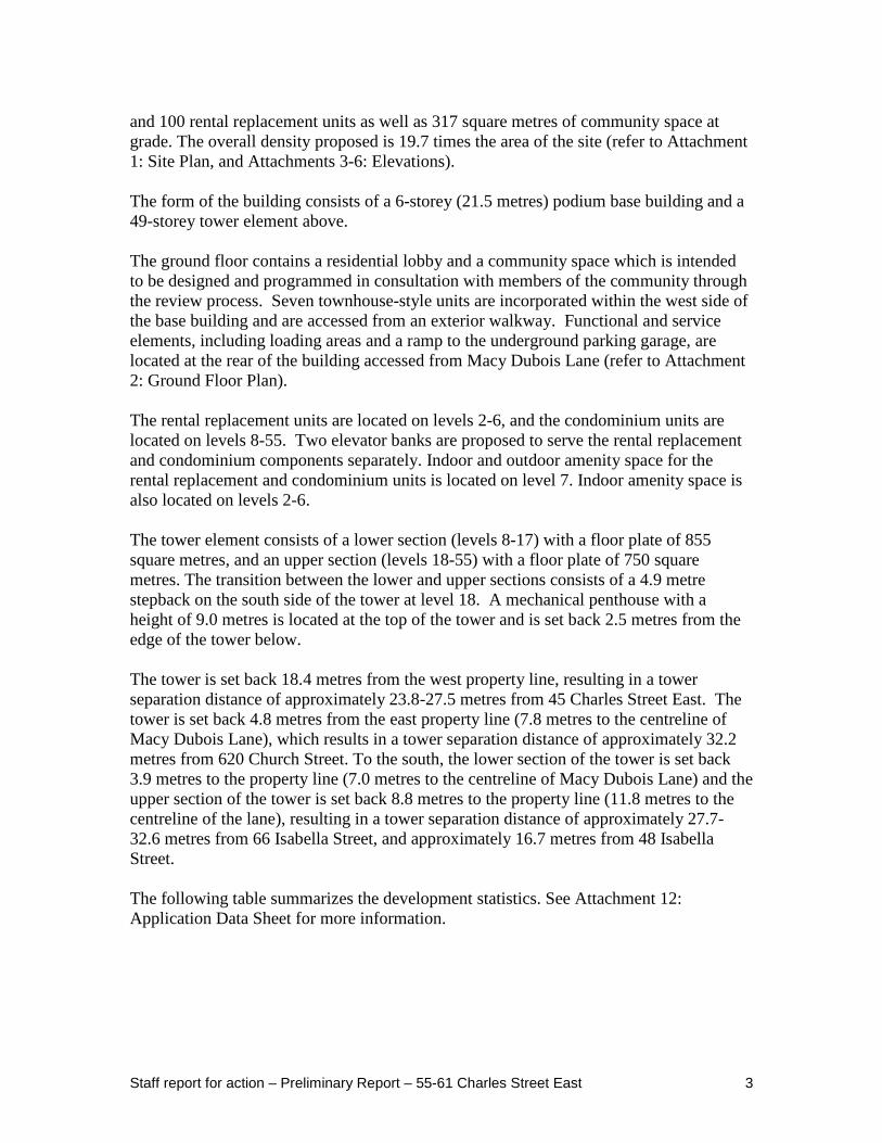
SUMMARY This report provides preliminary information and an early opportunity to raise issues for follow-up with regard to the applications. It seeks Community Council's direction on the community consultation process and indicates the expected timing for a Final Report to City Council. The application has been circulated to all appropriate agencies and City divisions for comment and a staff review of the application is underway. This application proposes a 55-storey (178.5 metres, including mechanical penthouse) residential building at 55-61 Charles Street East, consisting of a 6-storey podium base building and a 49-storey tower element above. A total of 548 condominium units and 100 rental replacement units are proposed in the building, and 317 square metres of community space is proposed at grade. A total of 154 parking spaces and 649 bicycle parking spaces are proposed in a 4-level underground parking garage accessed from Macy Dubois Lane.

Staff report for action – Preliminary Report – 55-61 Charles Street East 2
A notice of complete application with regard to the application was issued on May 17, 2018. An application for Rental Housing Demolition and Conversion under Section 111 of the City of Toronto Act (Chapter 667 of the Municipal Code) has been submitted and will be reviewed concurrently with the Zoning By-law Amendment application. A Community Consultation Meeting is anticipated to be held in the first quarter of 2019. A Final Report will be submitted for Council's consideration following community consultation, the resolution of outstanding issues related to this application and the holding of a statutory Public Meeting under the Planning Act. The Final Report is targeted for the first quarter of 2019, provided the applicant submits all the required information in a timely manner. RECOMMENDATIONS The City Planning Division recommends that: 1. Staff be directed to schedule a community consultation meeting for the lands at
55-61 Charles Street East together with the Ward Councillor. 2. Notice for the community consultation meeting be given to landowners and
residents within 120 metres of the site. 3. Notice for the statutory public meeting under the Planning Act be given according
to the regulations of the Planning Act. Financial Impact The recommendations in this report have no financial impact.
DECISION HISTORY A pre-application consultation meeting was held with the applicant on January 18, 2018 to discuss complete application submission requirements and the applicable policies and guidelines which would apply to the site. The application was submitted on April 16, 2018. Some revisions to the proposal were made following the pre-application meetings in response to the comments provided by staff. ISSUE BACKGROUND
Proposal The applicant has submitted a Zoning By-law Amendment application and Rental Housing Demolition application to develop a new 55-storey (178.5 metres, including mechanical penthouse) residential building containing a total of 548 condominium units
Staff report for action – Preliminary Report – 55-61 Charles Street East 3
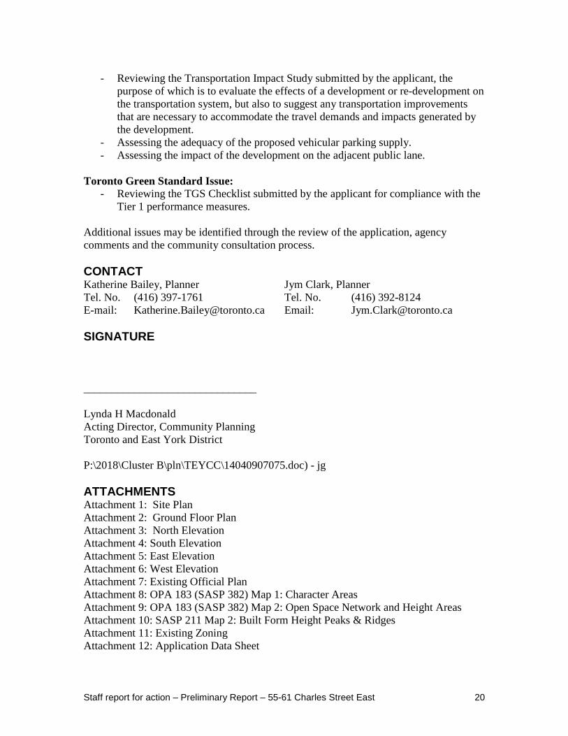
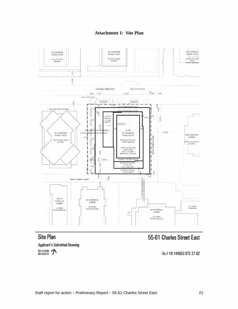
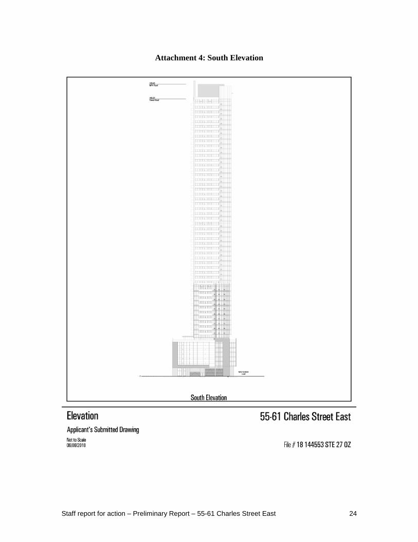
and 100 rental replacement units as well as 317 square metres of community space at grade. The overall density proposed is 19.7 times the area of the site (refer to Attachment 1: Site Plan, and Attachments 3-6: Elevations). The form of the building consists of a 6-storey (21.5 metres) podium base building and a 49-storey tower element above. The ground floor contains a residential lobby and a community space which is intended to be designed and programmed in consultation with members of the community through the review process. Seven townhouse-style units are incorporated within the west side of the base building and are accessed from an exterior walkway. Functional and service elements, including loading areas and a ramp to the underground parking garage, are located at the rear of the building accessed from Macy Dubois Lane (refer to Attachment 2: Ground Floor Plan). The rental replacement units are located on levels 2-6, and the condominium units are located on levels 8-55. Two elevator banks are proposed to serve the rental replacement and condominium components separately. Indoor and outdoor amenity space for the rental replacement and condominium units is located on level 7. Indoor amenity space is also located on levels 2-6. The tower element consists of a lower section (levels 8-17) with a floor plate of 855 square metres, and an upper section (levels 18-55) with a floor plate of 750 square metres. The transition between the lower and upper sections consists of a 4.9 metre stepback on the south side of the tower at level 18. A mechanical penthouse with a height of 9.0 metres is located at the top of the tower and is set back 2.5 metres from the edge of the tower below. The tower is set back 18.4 metres from the west property line, resulting in a tower separation distance of approximately 23.8-27.5 metres from 45 Charles Street East. The tower is set back 4.8 metres from the east property line (7.8 metres to the centreline of Macy Dubois Lane), which results in a tower separation distance of approximately 32.2 metres from 620 Church Street. To the south, the lower section of the tower is set back 3.9 metres to the property line (7.0 metres to the centreline of Macy Dubois Lane) and the upper section of the tower is set back 8.8 metres to the property line (11.8 metres to the centreline of the lane), resulting in a tower separation distance of approximately 27.7-32.6 metres from 66 Isabella Street, and approximately 16.7 metres from 48 Isabella Street. The following table summarizes the development statistics. See Attachment 12: Application Data Sheet for more information.

Staff report for action – Preliminary Report – 55-61 Charles Street East 4
Table 1: Site Statistics Category Proposed Development Site Area 2,283 square metres Building Height 55 storeys (178.5 metres including
mechanical) Base Building Height 6 storeys (21.5 metres) Base Building Setbacks
- North - South - East - West
2.2 metres 0 metres 0 metres 5.5 metres
Tower Floor Plate Levels 8-17: 855 square metres Levels 18-55: 750 square metres
Tower Stepbacks - North - South - East - West
3.0 metres 3.9 metres 4.8 metres 12.9 metres
Gross Floor Area - Residential - Community Space - Total
43,756 square metres 317 square metres 44,073 square metres
Density (FSI) 19.3 Number of Dwelling Units Rental Replacement
- Bachelor - 1 Bedroom - 2 Bedroom - 3 Bedroom - Total
Condominium - Bachelor - 1 Bedroom - 2 Bedroom - 3 Bedroom - Total
20 (20%) 75 (75%) 5 (5%) 0 (0%) 100 (100%) 66 (12%) 291 (53%) 128 (23%) 63 (11%) 548 (100%)
Vehicle Parking - Residential - Residential Visitors (operated as a
commercial parking garage) - Car Share
130 22 2
Bicycle Parking - Residential - Residential Visitors
584 65
Staff report for action – Preliminary Report – 55-61 Charles Street East 5
Residential Amenity Space - Indoor - Outdoor
1,296 square metres 855 square metres
Site and Surrounding Area The site is rectangular in shape and measures approximately 2,283 square metres with a frontage of 45.9 metres. The site is currently occupied by a 9-storey rental residential building at 55 Charles Street East containing 76 units, and a 3-storey rental residential building at 61-63 Charles Street East containing 24 units. According to the information provided by the applicant, the unit mix and rent classification for all existing rental units is as follows:
- 22 bachelor units: all 22 units have mid-range rents - 74 one-bedroom units: 3 units with affordable rents and 71 units with mid-range
rents - 4 two-bedroom: all 4 units have mid-range rents
At the time of application, four of the existing rental units were vacant. All others were occupied by tenants or building staff. Surrounding uses and buildings near the site include: North: On the north side of Charles Street East is a 55-storey mixed-use building
under construction at 50 Charles Street East ("Casa III") which includes the conservation of the 3-storey semi-detached house-form building at 62-64 Charles Street East which is listed on the City's Inventory of Heritage Properties. To the east is a 3-storey detached house-form building at 66 Charles Street East which is listed on the City's Inventory of Heritage Properties. At the northwest corner of Charles Street East and Church Street is a proposed 47-storey mixed-use building at 628 Church Street (City File No: 14 227468 STE 27 OZ). Further to the west on the north side of Charles Street East is a 56-storey residential building at 42 Charles Street East ("Casa II") and a 32-storey residential building at 35 Hayden Street ("The Bloor Street Neighbourhood"). To the west is a Part IV designated property with a 3-storey apartment building at 30 Charles Street East, and a 6-storey Toronto Parking Authority garage at 20 Charles Street East.
South: To the south of the site is the east-west portion of Macy DuBois Lane,
beyond which are properties fronting onto Isabella Street. At the northwest corner of Isabella Street and Church Street is a 26-storey mixed-use building at 66 Isabella Street. To the east is a 10-storey residential building at 48 Isabella Street, a 3 ½ -storey residential building at 40-42 Isabella Street which is listed on the City's Inventory of Heritage Properties, a 2 ½ -storey house-form building at 38 Isabella Street which is listed on the City's Inventory of Heritage Properties and houses an
Staff report for action – Preliminary Report – 55-61 Charles Street East 6
addiction treatment facility, a Part IV designated property with a 2 ½ -storey house-form building at 34 Isabella Street which houses the Canadian Lesbian and Gay Archives, a 7-storey office building at 30 Isabella Street which houses the Children's Aid Society of Toronto, and George Hislop Park.
East: To the east of the site is a north-south portion of Macy DuBois Lane. At
the southwest corner of Charles Street East and Church Street is a 26-storey hotel ("Town Inn Suites") at 620 Church Street which is subject to an application to permit two 3-storey infill apartment buildings on the property (City File No: 11 330270 STE 27 OZ). At the southeast corner of Charles Street East and Church Street is a 16-storey mixed use building at 71 Charles Street East ("Paxton Place"), and at the north-east corner is a 6-storey mixed-use commercial office building at 625 Church Street.
West: To the west of the site is a 47-storey residential building at 45 Charles
Street East ("Chaz Yorkville"), west of which is a north-south portion of Macy DuBois Lane. Further to the west is a 46-storey residential building at 33 Charles Street East ("Casa"), a church building at 25 Charles Street East which houses Sanctuary Ministries Toronto, and George Hislop Park. Further to the west are properties and a mix of uses generally located within the Yonge Street corridor.
Provincial Policy Statement and Provincial Plans The Provincial Policy Statement and geographically specific Provincial Plans, along with municipal Official Plans, provide a policy framework for planning and development in the Province. This framework is implemented through a range of land use controls such as zoning by-laws, plans of subdivision and site plans. The Provincial Policy Statement (2014) (the "PPS") provides policy direction province-wide on land use planning and development to promote strong communities, a strong economy, and a clean and healthy environment. It includes policies on key issues that affect communities, such as:
- The efficient and wise use and management of land and infrastructure over the long term in order to minimize impacts on air, water and other resources;
- Protection of the natural and built environment; - Building strong, sustainable and resilient communities that enhance health and
social well-being by ensuring opportunities exist locally for employment; - Residential development promoting a mix of housing; recreation, parks and open
space; and transportation choices that increase the use of active transportation and transit; and
- Encouraging a sense of place in communities, by promoting well-designed built form and by conserving features that help define local character.

Staff report for action – Preliminary Report – 55-61 Charles Street East 7
The provincial policy-led planning system recognizes and addresses the complex inter-relationships among environmental, economic and social factors in land use planning. The PPS supports a comprehensive, integrated and long-term approach to planning, and recognizes linkages among policy areas. The PPS is issued under Section 3 of the Planning Act and all decisions of Council in respect of the exercise of any authority that affects a planning matter shall be consistent with the PPS. Comments, submissions or advice affecting a planning matter that are provided by Council shall also be consistent with the PPS. The PPS is more than a set of individual policies. It is to be read in its entirety and the relevant policies are to be applied to each situation. The PPS recognizes and acknowledges the Official Plan as an important document for implementing the policies within the PPS. Policy 4.7 of the PPS states that, "The official plan is the most important vehicle for implementation of this Provincial Policy Statement. Comprehensive, integrated and long-term planning is best achieved through official plans." The Growth Plan for the Greater Golden Horseshoe (2017) (the "Growth Plan") provides a strategic framework for managing growth and environmental protection in the Greater Golden Horseshoe region, of which the City forms an integral part, including:
- Establishing minimum density targets within strategic growth areas and related policies directing municipalities to make more efficient use of land, resources and infrastructure to reduce sprawl, cultivate a culture of conservation and promote compact built form and better-designed communities with high quality built form and an attractive and vibrant public realm established through site design and urban design standards;
- Directing municipalities to engage in an integrated approach to infrastructure planning and investment optimization as part of the land use planning process;
- Building complete communities with a diverse range of housing options, public service facilities, recreation and green space that better connect transit to where people live and work;
- Retaining viable employment lands and encouraging municipalities to develop employment strategies to attract and retain jobs;
- Minimizing the negative impacts of climate change by undertaking stormwater management planning that assesses the impacts of extreme weather events and incorporates green infrastructure; and
- Recognizing the importance of watershed planning for the protection of the quality and quantity of water and hydrologic features and areas.
The Growth Plan builds upon the policy foundation provided by the PPS and provides more specific land use planning policies to address issues facing the GGH region. The policies of the Growth Plan take precedence over the policies of the PPS to the extent of any conflict, except where the relevant legislation provides otherwise.

Staff report for action – Preliminary Report – 55-61 Charles Street East 8
In accordance with Section 3 of the Planning Act all decisions of Council in respect of the exercise of any authority that affects a planning matter shall conform with the Growth Plan. Comments, submissions or advice affecting a planning matter that are provided by Council shall also conform with the Growth Plan. Provincial Plans are intended to be read in their entirety and relevant policies are to be applied to each situation. The policies of the Plans represent minimum standards. Council may go beyond these minimum standards to address matters of local importance, unless doing so would conflict with any policies of the Plans. All decisions of Council in respect of the exercise of any authority that affects a planning matter shall be consistent with the PPS and shall conform with Provincial Plans. All comments, submissions or advice affecting a planning matter that are provided by Council shall also be consistent with the PPS and conform with Provincial Plans. Policy 5.1 of the Growth Plan states that where a municipality must decide on a planning matter before its official plan has been amended to conform with this Plan, or before other applicable planning instruments have been updated accordingly, it must still consider the impact of its decision as it relates to the policies of the Growth Plan which require comprehensive municipal implementation. This planning application will be tested for consistency with the PPS and conformity with the Growth Plan. In the submission forms for development approval, the applicant has indicated that the application is consistent with the PPS and conforms to the applicable Provincial Plans. Staff will be evaluating this planning application against the PPS (2014) and the Growth Plan (2017) as part of the City's development approval process.
Official Plan This application will be reviewed against the official plan policies and/or planning studies described below as well as the policies of the Toronto Official Plan as a whole (refer to Attachment 7: Existing Official Plan). Downtown Policies The Official Plan places the site within the Downtown and Central Waterfront on Map 2 "Urban Structure." The policies for the Downtown describe a healthy and attractive place to live and work which will continue to evolve through new development, including intensification in the Mixed Use Areas and Regeneration Areas of Downtown, and sensitive infill within Downtown Neighbourhoods and Apartment Neighbourhoods. Design guidelines specific to districts of historic or distinct character will be developed and applied to ensure new development respects the context of such districts in terms of the development's fit with existing streets, setbacks, heights and relationship to landmark buildings (refer to Policies 2.2.1.5 and 2.2.1.6). In this case, the North Downtown Yonge Street Urban Design Guidelines have been prepared to implement Policy 2.2.1.6.

Staff report for action – Preliminary Report – 55-61 Charles Street East 9
Mixed Use Areas Policies The site is designated "Mixed Use Areas" on Map 18 – Land Use Plan in the Official Plan and is subject to Policy 4.5. This designation permits a range of residential, commercial and institutional uses, in single use or mixed use buildings, as well as parks and open spaces and utilities. Development in Mixed Use Areas will provide a balance of uses which meet the needs of the local community; have access to schools, parks, community centres, libraries and childcare; include on-site indoor and outdoor recreation space for residents; and take advantage of nearby transit services and allow for reduced automobile dependency. New buildings should be located and massed to provide a transition between areas of different development intensity and scale; frame streets with good proportion and provide an attractive, comfortable and safe environment for pedestrians, including maintaining sunlight and comfortable wind conditions; provide good site access, circulation, and adequate parking for residents and visitors; and locate and screen service areas, ramps and garbage storage to minimize the impact on adjacent streets and residences. Built Form Policies The development criteria in the Mixed Use Areas policies are supplemented by additional development criteria in the Official Plan’s Built Form policies, including policies that specifically address tall buildings. The Built Form policies emphasize the importance of ensuring that new development fits within its existing and/or planned context, while limiting impacts on neighbouring streets, parks and open spaces. New buildings are required to provide appropriate massing and transition in scale that will respect the character of the surrounding area. The Built Form policies (Policy 3.1.2) identify the importance of urban design as a fundamental element of City building. They require that new development:
- be located and organized to fit with its existing and/or planned context; - frame and support adjacent streets, parks and open spaces; - locate and organize vehicular and service areas in such a way to minimize their
impact and to improve the safety and attractiveness of adjacent streets, parks and open spaces;
- be massed and its exterior façade be designed to fit harmoniously into its existing and/or planned context and to limit its impact by, among other things, creating appropriate transitions in scale as well as adequately limiting the resulting shadowing and wind conditions on neighbouring streets, properties and open spaces;
- be massed to define edges of streets, parks and open spaces; - provide amenity for adjacent streets and open spaces for pedestrians; and - provide indoor and outdoor amenity space for residents.
The policies of Section 3.1.3 also indicate that tall buildings come with larger civic responsibilities and obligations than other buildings. To ensure that tall buildings fit within their existing and/or planned context and limit local impacts, additional built form principles will be applied to the location and design of tall buildings. Additionally,

Staff report for action – Preliminary Report – 55-61 Charles Street East 10
Official Plan Amendment (OPA) 352 was adopted by City Council on October 5-7, 2016 (currently under appeal). OPA 352 establishes the policy context for tall building setbacks and separation distances between tower portions of tall buildings Downtown. Heritage Policies Section 3.1.5 provides policies regarding heritage conservation. Policy 3.1.5.5 states that proposed development on or adjacent to a property on the Heritage Register will ensure that the integrity of the heritage property's cultural heritage value and attributes will be retained. Policy 3.1.5.26 requires that new construction on, or adjacent to, a property on the Heritage Register will be designed to conserve the cultural heritage values, attributes and character of that property and to mitigate visual and physical impact on it. The adjacent properties at 62-64 Charles Street East, 66 Charles Street East, and 40-42 Isabella Street are listed on the City's Heritage Register. Housing Policies The Official Plan contains policies addressing the need to preserve and increase the City’s supply of rental and affordable housing. Policy 3.2.1 of the Official Plan includes housing policies that encourage the provision of a full range of housing in terms of form, tenure and affordability. The Plan states that the existing stock of housing will be maintained and replenished. New housing supply will be encouraged through intensification and infill that is consistent with the overall policies of the Official Plan. Policy 3.2.1.6 states that for new development that would have the effect of removing all or a part of a private building or related group of buildings, and would result in the loss of six or more rental housing units, the following items will be secured:
- at least the same number, size and type of rental housing units are replaced and maintained with rents similar to those in effect at the time the redevelopment application is made;
- for a period of at least 10 years, rents for replacement units will be the rent at first occupancy increased annually by not more than the Provincial Rent Increase Guideline or a similar guideline as Council may approve from time to time; and
- an acceptable tenant relocation and assistance plan addressing the right to return to occupy one of the replacement units at similar rents, the provision of alternative accommodation at similar rents, and other assistance to lessen hardship.
Parkland Acquisition and Tree Preservation Policies The Official Plan includes policies for parkland acquisition as well as criteria for the location and configuration of parks. In addition, Section 3.4 of the Official Plan contains policies that discourage tree removal and promote increasing the tree canopy coverage in the City.

Staff report for action – Preliminary Report – 55-61 Charles Street East 11
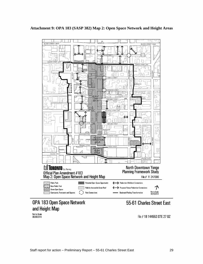
North Downtown Yonge Site and Area Specific Policy 382 and North Downtown Yonge Urban Design Guidelines At its meeting on November 13, 2013, City Council adopted the North Downtown Yonge Area Specific Policy 382, known as Official Plan Amendment (OPA) 183, and approved the North Downtown Yonge Urban Design Guidelines for the area generally bounded by Charles Street, Bay Street, Church Street and College/Carlton Street. Parts of OPA 183 were adopted by the OMB in a Phase I hearing and are in full force and effect, including the majority of the Isabella Character Area policies and the area-wide policies. Other parts of OPA 183, including the policies related to the Historic Yonge Street HCD, remain under appeal and will be addressed through a Phase II hearing, which is not yet scheduled. The site is located within the Isabella Character Area which extends from the properties on the south side of Charles Street East to the properties on the north side of Gloucester Street, between the linear park east of Yonge Street and the rear of the properties fronting on Church Street (refer to Attachments 8-9: OPA 183 (SASP 382)). The commentary section of Section 5.4, Isabella Character Area, notes that the area along Charles Street East designated Mixed Use Areas will continue to experience growth and change while the area to the south has remained relatively stable and is not intended for significant growth and intensification. OPA 183 also contains area-wide policies related to sun and shadows, parks and open spaces, the public realm, and urban design, which will be considered during the review of the application. The North Downtown Yonge Urban Design Guidelines provide further direction for implementation of the policies contained in OPA 183. A unique aspect of the Isabella Character Area is its special built form and open space configuration which results in large separation distances from adjacent properties and porosity through the block. The open spaces on these blocks are valuable and contribute to the quality of life for residents. Infill developments on these blocks shall:
- Protect the low-rise built form, heritage buildings and human pedestrian scale; - Maintain the open space network by identifying sites that can complement and
enhance the existing public open spaces; Additionally:
- The height of new developments should create a height transition from Yonge Street to the midrise built form along Church Street.
- There shall be a compatible relationship of potential new developments to the street right-of-way, immediate context, existing heritage buildings, nearby parks and open spaces and Neighbourhoods.
- The streetscape should provide strong street edges with tree planting, minimum paved sidewalk width and be in conformity with the City of Toronto Streetscape Manual.

Staff report for action – Preliminary Report – 55-61 Charles Street East 12
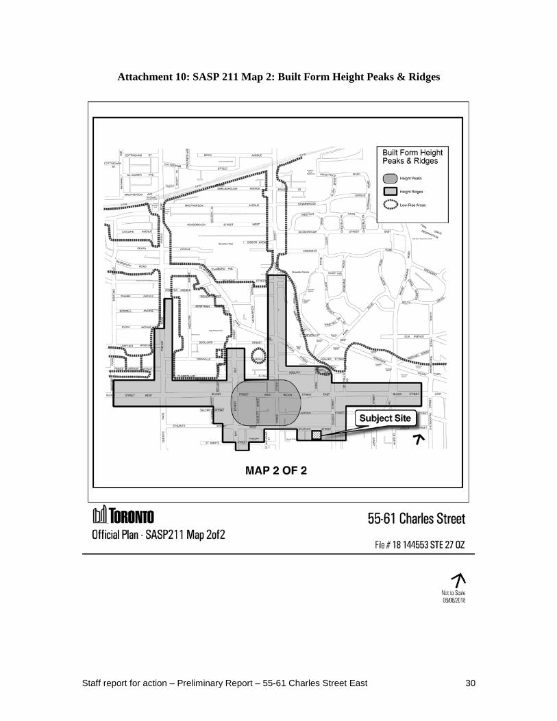
The Urban Design Guidelines also contain a framework for built form and the public realm, which will be considered during the review of the application. Site and Area Specific Policy 211 Site and Area Specific Policy (SASP) 211 in the Official Plan recognizes that the Bloor-Yorkville/North Midtown Area comprises a broad mix of districts with differing intensities, scales and heights in a diversity of building forms. It forms the north edge of the Downtown and provides for transition in density and scale towards the boundaries of the area from the more intensive use and development forms to the south and within the Height Peak at Yonge Street and Bloor Street. Map 2 of SASP 211 provides a height structure plan for the area, comprising of a "Height Peak," "Height Ridges," and "Low-Rise Areas." The site is located at the southern edge of the Church Street Height Ridge (refer to Attachment 10: SASP 211). The policy states that the tallest buildings in the Bloor-Yorkville/North Midtown area will be located in the Height Peak, located in the vicinity of the intersection of Yonge Street and Bloor Street, with height and density permissions generally diminishing the further one gets from Bloor Street. Development along the Height Ridges will be at a lesser height and physical scale than the Bloor/Yonge Height Peak, and in a form compatible with adjacent areas. The Bloor-Yorkville/North Midtown Urban Design Guidelines have been prepared to provide direction for reviewing development applications in this area; however, the extent of the Study Area within the Urban Design Guidelines does not include the site. TOcore: Planning Downtown OPA 406 – Downtown Plan At its May 1, 2018 meeting, Planning and Growth Management (PGM) Committee held a Special Public Meeting pursuant to Section 26 of the Planning Act and adopted a staff report entitled "TOcore: Downtown Plan Official Plan Amendment", as amended, that recommended adoption of the Downtown Plan Official Plan Amendment (OPA 406). OPA 406 includes amendments to Section 2.2.1 and Map 6 of the Official Plan, as well as a new Downtown Plan. Future amendments to existing Secondary Plans and Site and Area Specific Policies located within the Downtown area are recommended to be implemented once OPA 406 comes into force and effect. At its May 22-24, 2018 meeting, City Council adopted OPA 406, as amended. The Council decision is available here: http://app.toronto.ca/tmmis/viewAgendaItemHistory.do?item=2018.PG29.4 Pursuant to Section 26 of the Planning Act, the Downtown Plan will be forwarded to the Minister of Municipal Affairs for approval. Council has directed Staff to use the policies contained with the Downtown Plan to inform evaluation of current and future development applications in the Downtown Plan area while the OPA is under consideration by the Minister.

Staff report for action – Preliminary Report – 55-61 Charles Street East 13
The OPA – in conjunction with the associated infrastructure strategies that address water, energy, mobility, parks and public realm and community services and facilities – is the result of a four-year study called TOcore: Planning Downtown. The TOcore study area is generally bounded by Lake Ontario to the south, Bathurst Street to the west, the mid-town rail corridor and Rosedale Valley Road to the north and the Don River to the east. This OPA brings forward a comprehensive and integrated policy framework to shape growth in Toronto’s fast-growing Downtown over the next 25 years. It provides the City with a blueprint to align growth management with the provision of infrastructure, sustain liveability, achieve complete communities and ensure there is space for the economy to grow. As part of the City of Toronto’s Five Year Official Plan Review under Section 26 of the Planning Act, OPA 406 is a component of the work program to bring the Official Plan into conformity with the Growth Plan. City Council declared that OPA 406 is consistent with the Provincial Policy Statement (2014), conforms with the Growth Plan and has regard to matters of provincial interest under Section 2 of the Planning Act. OPA 352 – Downtown Tall Building Setback Area On October 5-7, 2016, City Council adopted Official Plan Amendment (OPA) 352 – Downtown Tall Building Setback Area (currently under appeal). The purpose of OPA 352 is to establish the policy context for tall building setbacks and separation distances between tower portions of tall buildings Downtown. At the same meeting, City Council adopted area-specific Zoning By-laws 1106-2016 and 1107-2016 (also under appeal), which provide the detailed performance standards for portions of buildings above 24 metres in height. At its meeting on October 2-4, 2017, City Council considered the Proposed Downtown Plan and directed Staff to undertake stakeholder and public consultation on that document and its proposed policies, leading to the Downtown Plan Official Plan Amendment. Further background information can be found at www.toronto.ca/tocore. Map 41-3 of the new Downtown Plan designates this site as Mixed-Use Area 2 – Intermediate. The existing character and planned context of Mixed Use Areas 2 form an intermediate, transitional scale between the taller buildings anticipated on some sites in Mixed Use Areas 1 and the predominantly mid-rise character anticipated in Mixed Use Areas 3. Development in Mixed Use Areas 2 may be of a scale and typology that is unique and responds to the existing character of those areas. This intermediate or “in-between” scale of development will respond to unique built form contexts. The new Downtown Plan also contains area-wide policies related to parks and public realm, mobility, built form, community services and facilities, housing, and energy and resilience, which will be considered during the review of the application.
Staff report for action – Preliminary Report – 55-61 Charles Street East 14
City-Wide Tall Building Design Guidelines In May 2013, Toronto City Council adopted the updated city-wide Tall Building Design Guidelines and directed City Planning staff to use these Guidelines in the evaluation of all new and current tall building development applications. The guidelines establish a unified set of performance measures for the evaluation of tall building proposals to ensure that they fit within their context and minimize their local impacts. The city-wide Guidelines are available at http://www.toronto.ca/planning/tallbuildingdesign.htm Policy 1 in Section 5.3.2, Implementation Plans and Strategies for City-Building, the Official Plan states that Guidelines will be adopted to advance the vision, objectives, and policies of the Plan. Urban Design guidelines specifically are intended "to provide a more detailed framework for built form and public improvements in growth areas." The Tall Building Design Guidelines serve this policy intent, helping to implement Chapter 3.1, The Built Environment, and other policies within the Official Plan related to the design and development of tall buildings in Toronto. The guidelines state that the tower floorplate size should be limited to 750 square metres or less per floor, including all built area within the building but excluding balconies. The tower floor plate should be located and articulated to minimize shadow impacts and negative wind conditions on surrounding streets, parks, open space, and properties; minimize loss of sky view from the public realm; allow for the passage of natural light into interior spaces; create architectural interest and visually diminish the overall scale of the building mass; and present an elegant profile for the skyline. Tower placement is addressed in Sections 3.2.2 and 3.2.3 of the Guidelines. Tall building towers should be set back 12.5 metres or greater from the side and rear property lines or centre line of an abutting lane. The tower, including balconies, should step back 3 metres or more from the base building along all street frontages. Tower stepbacks greater than 3 metres are encouraged and may be required for tall buildings to fit harmoniously within an existing context, including sites that contain or are adjacent to heritage properties.
Downtown Tall Buildings: Vision and Supplementary Design Guidelines This project is located within an area that is also subject to the Downtown Tall Buildings: Vision and Supplementary Design Guidelines (adopted by City Council in July 2012 and consolidated with the city-wide Tall Building Design Guidelines May 2013). This document identifies where tall buildings belong Downtown, and establishes a framework to regulate their height, form and contextual relationship to their surroundings. The Downtown Vision and Supplementary Design Guidelines should be used together with the city-wide Tall Building Design Guidelines to evaluate new and current Downtown tall building proposals. On Map 1 - High Streets Map - Charles Street East is shown as a Secondary High Street.
Staff report for action – Preliminary Report – 55-61 Charles Street East 15
On Map 2 - Downtown Vision Height Map - no height range has been established for the Secondary High Streets. Section 1.2 states that the height ranges for Secondary High Streets will generally be one-third lower than the High Streets they run parallel to. A height range of 77-137 metres (25-45 storeys) is applied to Bloor Street East between Yonge Street and Church Street, 62-107 metres (20-35 storeys) is applied to the southwest and southeast corners of Church Street and Bloor Street East, and 47-77 metres (15-25 storeys) is applied to the east side of Church Street north of Charles Street East. Map 3 - High Streets Typologies Map - applies a Tower-Base Form or Residential Landscaped Setback Form to Charles Street East. Growing Up Draft Urban Design Guidelines In July 2017, Toronto City Council adopted the Growing Up Draft Urban Design Guidelines, and directed City Planning staff to apply the "Growing Up Guidelines" in the evaluation of new and under review multi-unit residential development proposals. The objective of the Growing Up Draft Urban Design Guidelines is that developments deliver tangible outcomes to increase liveability for larger households, including families with children at the neighbourhood, building and unit scale. The Growing Up Draft Urban Design Guidelines are available at https://www.toronto.ca/legdocs/mmis/2017/pg/bgrd/backgroundfile-103920.pdf The Growing Up Draft Urban Design Guidelines will be considered during the review of the application.
Zoning The site is zoned CR T2.0 C1.0 R2.0 in Zoning By-law 438-86, which permits a mix of commercial and residential uses. The maximum permitted height is 30 metres and the maximum permitted density is 2 times the lot area. Other site specific permissions and exceptions from Section 12(2)80 and 12(2)132 also apply which limit the use of parking facilities and prohibit commercial parking garage uses, respectively. On May 9, 2013, City Council enacted city-wide Zoning By-law 569-2013. Planning Act applications submitted after May 9, 2013, are subject to the new Zoning By-law. The site is zoned CR 2.0 (c1.0; r2.0) SS1 (x1454) in Zoning By-law 569-2013 (refer to Attachment 11: Existing Zoning). The CR zone permits a range of uses similar to the former designation under Zoning By-law 438-86 and a maximum permitted height of 30 metres. The (x1454) provisions indicate site specific permissions and exceptions that are carried over from Zoning By-law 438-86.
Site Plan Control The application is subject to Site Plan Control. An application for Site Plan Control has been submitted and is currently under review.

Staff report for action – Preliminary Report – 55-61 Charles Street East 16
Rental Housing Demolition and Conversion By-law Section 111 of the City of Toronto Act, 2006 authorizes City Council to regulate the demolition and conversion of residential rental properties in the City. Chapter 667 of the City's Municipal Code, the Rental Housing Demolition and Conversion By-law, implements Section 111. The By-law prohibits the demolition or conversion of rental housing units in buildings containing six or more residential units, of which at least one unit is rental, without obtaining a permit from the City and requires a decision by either City Council or the Chief Planner. Council may refuse an application, or approve the demolition with conditions that must be satisfied before a demolition permit is issued. These conditions implement the City’s Official Plan policies protecting rental housing. Council approval of demolition under Section 33 of the Planning Act may also be required where six or more residential units are proposed for demolition before the Chief Building Official can issue a permit for demolition under the Building Code Act. Where an application for rezoning triggers an application under Chapter 667 for rental demolition or conversion, City Council typically considers both applications at the same time. Unlike Planning Act applications, decisions made by City Council under By-law 885-2007 are not appealable to the Local Planning Appeal Tribunal (LPAT). On April 16, 2018, the applicant made an application for a Section 111 permit pursuant to Chapter 667 of the City of Toronto Municipal Code. As per Chapter 667-14, a tenant consultation meeting will be held to review the impact of the proposal on tenants of the residential rental property and matters under Section 111. City staff will be reviewing the submitted materials, including the Housing Issues Report, to evaluate the appropriateness of the rental replacement strategy and measures to mitigate hardship for tenants.
COMMENTS
Reasons for the Application The proposal requires an amendment to the Zoning By-law for an increase in building height and density, reduction in parking space rates and outdoor amenity space, and other development standards that will require site specific zoning provisions. The applicant has submitted an application for a Section 111 permit pursuant to Chapter 667 of the City of Toronto Municipal Code for the demolition of the existing rental housing units as the subject lands contain six or more residential units, of which at least one is rental.
Complete Application Submission A complete application was submitted on April 16, 2018. A Notification of Complete Application was issued on May 17, 2018.

Staff report for action – Preliminary Report – 55-61 Charles Street East 17
The following reports/studies have been submitted with the application:
- Boundary and Topographical Survey; - Architectural Plans; - Shadow Study; - Landscape Plans; - Tree Preservation Plan; - Arborist Report; - Planning and Urban Design Report; - Public Consultation Strategy; - Community Services & Facilities Study; - Draft Zoning By-law Amendments; - Rental Housing Demolition and Conversion Declaration of Use & Screening
Form; - Housing Issues Report; - Toronto Green Standards Development Checklist; - Heritage Impact Assessment; - Qualitative Pedestrian Level Wind Assessment; - Transportation Impact Study; - Functional Servicing Report - Stormwater Management Report; - Geohydrology Assessment; - Geotechnical Investigation Report; - Energy Strategy; and - Phase I Environmental Site Assessment.
A Notice of Complete Application was issued on May 17, 2018, deeming the application complete as of April 16, 2018. The application materials are available at http://aic.to/55CharlesE Community Consultation The applicant has submitted a Public Consultation Strategy as part of the complete application submission requirements. The Public Consultation Strategy includes the community consultation meeting hosted by the City of Toronto, which will be attended by the development team and the statutory public meeting. The applicant has advised that they also intend to meet with the Church Wellesley Neighbourhood Association to discuss the development proposal. Community consultation helps to inform Council in respect of the exercise of its authority to make a decision with regard to the planning application. This Report seeks Community Council's direction on the community consultation process.
Staff report for action – Preliminary Report – 55-61 Charles Street East 18
ISSUES TO BE RESOLVED Provincial Policies and Plans Consistency/Conformity Exercise Issue:
- Evaluating this planning application against the Planning Act, including the matters of provincial interest contained in section 2(j), 2(p) and 2(r).
- Evaluating this planning application against the PPS (2014), including policy 1.1.3.3, to establish the application's consistency with the PPS.
- Evaluating this planning application against the Growth Plan (2017), including policies 2.2.1.4 and 2.2.2.4, to establish the application's conformity with the Growth Plan.
Official Plan Conformity Exercise Issue:
- Determining conformity with the Official Plan, including the development criteria for Mixed Use Areas.
- Determining conformity with the policies of SASP 382 and SASP 211, particularly in relation to the planned height transition from the Yonge/Bloor intersection to the edge of the Mixed Use Areas designation.
- Consideration of not-in-force policies of the Toronto Official Plan, including OPA 406 and OPA 352.
Built Form Impacts Issue:
- Assessing and confirming the suitability of the proposed height, density and massing of the application based on Provincial policies and plans, the City's Official Plan policies and design guidelines.
- Assessing and confirming the suitability of the building design at grade, including the appropriateness of townhouse units that do not front onto a public street, the proposed community space, and provision of amenity/open space.
- Reviewing the background studies submitted with the application such as the Sun/Shadow Studies, Pedestrian Level Wind Studies, etc.
- Assessing the appropriateness of the shadow impacts created by the proposal on the surrounding area.
- Assessing the appropriateness of the wind conditions and proposed wind mitigation measures.
- Assessing transition impacts to adjacent areas and impacts on the public realm. - Assessing the quantity, placement, and design of indoor and outdoor amenity
space. - Assessing the appropriateness of the proposed site circulation, servicing, loading
and garbage storage. Public Realm and Streetscape Issue:
- Ensuring adequate space for pedestrians along the Charles Street East frontage. - Providing for appropriate landscaping and tree planting on Charles Street East and
the other laneway and walkway frontages.
Staff report for action – Preliminary Report – 55-61 Charles Street East 19
Housing Issue: - Evaluating the appropriateness of the rental housing replacement proposal,
including the size, unit design and associated amenities for the proposed replacement housing.
- Evaluating the suitability of the tenant relocation and assistance plan for the affected tenants.
Tree Preservation Issue: - The application is subject to the provisions of the City of Toronto Municipal
Code, Chapter 813 Articles II (Street Trees by-law) and III (Private Tree by-law). The Arborist Report submitted with the application identifies 6 City-owned trees which are to be removed to facilitate the proposal. The Arborist Report and Tree Preservation Plan have been circulated to Urban Forestry for review.
Heritage Impact & Conservation Strategy Issue:
- Reviewing the Heritage Impact Assessment submitted with the application and evaluating whether the application will have an impact on cultural heritage resources.
Community Services Assessment Issue:
- Evaluating the impact of the proposed development and local development activity on community services and facilities, including assessment of existing capacity to support proposed future population.
- Reviewing community services and facilities policies, site specific policies and growth related studies that apply to the application.
- Reviewing the Community Services & Facilities Study that was submitted with the application and to determine whether any capital improvements or expansion of facilities opportunities were identified by the applicant or by staff and follow up any Study deficiencies that need to be addressed.
Section 37 Community Benefits Issue:
- Reviewing the appropriate provision of Section 37 community benefits should the application proceed to approval.
Infrastructure/Servicing Capacity to Support Application Issue:
- Reviewing the application to determine if there is sufficient infrastructure (roads, transit, water, sewage, hydro, community services and facilities, etc.) capacity to accommodate the proposed development.
- Determining the potential cumulative impact of all proposed applications in the area of this application.
- Reviewing the Functional Servicing Report provided by the applicant with the submission, the purpose of which is intended to evaluate the effects of a proposed change in land use or development on the City’s municipal servicing infrastructure and watercourses and identify and provide the rationale for any new infrastructure and upgrades to existing infrastructure necessary to provide for adequate servicing to the proposed change in land use or development.
Staff report for action – Preliminary Report – 55-61 Charles Street East 20
- Reviewing the Transportation Impact Study submitted by the applicant, the purpose of which is to evaluate the effects of a development or re-development on the transportation system, but also to suggest any transportation improvements that are necessary to accommodate the travel demands and impacts generated by the development.
- Assessing the adequacy of the proposed vehicular parking supply. - Assessing the impact of the development on the adjacent public lane.
Toronto Green Standard Issue:
- Reviewing the TGS Checklist submitted by the applicant for compliance with the Tier 1 performance measures.
Additional issues may be identified through the review of the application, agency comments and the community consultation process. CONTACT Katherine Bailey, Planner Jym Clark, Planner Tel. No. (416) 397-1761 Tel. No. (416) 392-8124 E-mail: [email protected] Email: [email protected] SIGNATURE _______________________________ Lynda H Macdonald Acting Director, Community Planning Toronto and East York District P:\2018\Cluster B\pln\TEYCC\14040907075.doc) - jg ATTACHMENTS Attachment 1: Site Plan Attachment 2: Ground Floor Plan Attachment 3: North Elevation Attachment 4: South Elevation Attachment 5: East Elevation Attachment 6: West Elevation Attachment 7: Existing Official Plan Attachment 8: OPA 183 (SASP 382) Map 1: Character Areas Attachment 9: OPA 183 (SASP 382) Map 2: Open Space Network and Height Areas Attachment 10: SASP 211 Map 2: Built Form Height Peaks & Ridges Attachment 11: Existing Zoning Attachment 12: Application Data Sheet
Staff report for action – Preliminary Report – 55-61 Charles Street East 21
Attachment 1: Site Plan

Staff report for action – Preliminary Report – 55-61 Charles Street East 22
Attachment 2: Ground Floor Plan

Staff report for action – Preliminary Report – 55-61 Charles Street East 23
Attachment 3: North Elevation
Staff report for action – Preliminary Report – 55-61 Charles Street East 24
Attachment 4: South Elevation
Staff report for action – Preliminary Report – 55-61 Charles Street East 25
Attachment 5: East Elevation

Staff report for action – Preliminary Report – 55-61 Charles Street East 26
Attachment 6: West Elevation

Staff report for action – Preliminary Report – 55-61 Charles Street East 27
Attachment 7: Existing Official Plan

Staff report for action – Preliminary Report – 55-61 Charles Street East 28
Attachment 8: OPA 183 (SASP 382) Map 1: Character Areas
Staff report for action – Preliminary Report – 55-61 Charles Street East 29
Attachment 9: OPA 183 (SASP 382) Map 2: Open Space Network and Height Areas
Staff report for action – Preliminary Report – 55-61 Charles Street East 30
Attachment 10: SASP 211 Map 2: Built Form Height Peaks & Ridges

Staff report for action – Preliminary Report – 55-61 Charles Street East 31
Attachment 11: Existing Zoning
Staff report for action – Preliminary Report – 55-61 Charles Street East 32
Attachment 12: Application Data Sheet
Municipal Address: 55 CHARLES ST E Date Received: April 16, 2018
Application Number: 18 144553 STE 27 OZ
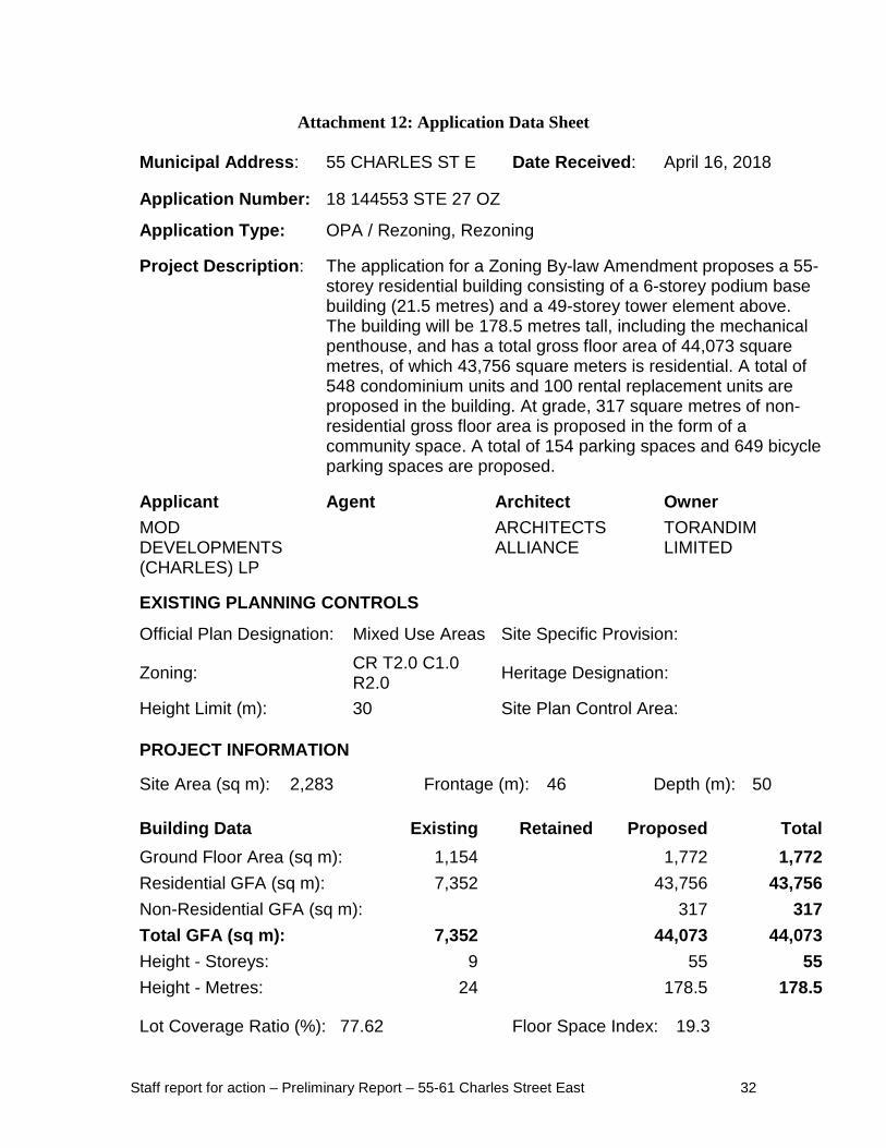
Application Type: OPA / Rezoning, Rezoning Project Description: The application for a Zoning By-law Amendment proposes a 55-
storey residential building consisting of a 6-storey podium base building (21.5 metres) and a 49-storey tower element above. The building will be 178.5 metres tall, including the mechanical penthouse, and has a total gross floor area of 44,073 square metres, of which 43,756 square meters is residential. A total of 548 condominium units and 100 rental replacement units are proposed in the building. At grade, 317 square metres of non-residential gross floor area is proposed in the form of a community space. A total of 154 parking spaces and 649 bicycle parking spaces are proposed.
Applicant Agent Architect Owner MOD DEVELOPMENTS (CHARLES) LP
ARCHITECTS ALLIANCE
TORANDIM LIMITED
EXISTING PLANNING CONTROLS
Official Plan Designation: Mixed Use Areas Site Specific Provision:
Zoning: CR T2.0 C1.0 R2.0 Heritage Designation:
Height Limit (m): 30 Site Plan Control Area: PROJECT INFORMATION
Site Area (sq m): 2,283 Frontage (m): 46 Depth (m): 50 Building Data Existing Retained Proposed Total Ground Floor Area (sq m): 1,154 1,772 1,772 Residential GFA (sq m): 7,352 43,756 43,756 Non-Residential GFA (sq m): 317 317 Total GFA (sq m): 7,352 44,073 44,073 Height - Storeys: 9 55 55 Height - Metres: 24 178.5 178.5
Lot Coverage Ratio (%): 77.62 Floor Space Index: 19.3

Staff report for action – Preliminary Report – 55-61 Charles Street East 33
Floor Area Breakdown Above Grade (sq m) Below Grade (sq m) Residential GFA: 43,756 Retail GFA: Office GFA: Industrial GFA: Institutional/Other GFA: 317
Residential Units by Tenure Existing Retained Proposed Total
Rental: 100 100 100 Freehold: Condominium: 548 548 Other: Total Units: 100 648 648
Total Residential Units by Size Rooms Bachelor 1 Bedroom 2 Bedroom 3+ Bedroom Retained: Proposed: 86 366 133 63 Total Units: 86 366 133 63
Parking and Loading
Parking Spaces: 154 Bicycle Parking Spaces: 649 Loading Docks: 2 CONTACT:
Katherine Bailey, Planner 416-397-1761 [email protected]