6. ehc lakeside south: historic walks in and around egg
TRANSCRIPT

1. Antwerp Ave Rail-bed: The German-speaking settlement envisioned by Egg Harbor City’s founders in 1854 included two downtowns: one at the City’s current site and one at Gloucester Landing, serving as a port. The two were to be connected by a railroad, started but never completed. That’s why Antwerp and Boston Aves are wider than most of the others. The rail-bed extends straight northeast from Beethoven St. for 2.8 miles to Indian Cabin Rd, and beyond that to where it would have crossed Landing Creek. (You can still see pilings – for a trestle – in the creek-bed.) There is a missing bridge across Elliot’s Branch, at a picnic site near the Renault Winery: the creek can be forded or bypassed by side-roads out to Bremen Ave, as shown on the map. The path is elevated at several places, permitting superb views across wetland wilderness.
Historic Walks In and Around
Egg Harbor City
By Dick ColbyEgg Harbor City Historical Society
533 London AveEgg Harbor City NJ 08215
[Feb 2020]
Thanks to some abandoned and never-built railroad right-of-ways, and former industrial
sites, there are many opportunities to enjoy walks through the woods and in Egg Harbor City proper.
Precautions: Tick season is from the time of the first buds in spring to the second hard frost. Chigger season starts later but also ends with the second hard frost. Legs should not be exposed, and Deet spray should be used. An entire body search should be carried out after walking in the woods or along roadsides. These days one almost always carries a cell phone, and water, and wears a hat and long sleeves. And one NEVER leaves trash.
improved dirt road, is a difficult leftward path across wetlands, rising eventually to higher ground and several trail-connections that include the old unimproved Columbia Road.
6. EHC Lakeside South: Along the south of the western half of EHC Lake. Connecting Hamburg and Philadelphia Aves, north of Cedar Creek High School, are several alternative routes through the woods. The entrance from the northwest is where the pavement of Hamburg Ave ends, now the corner of Kant St. There are two entrances from Philadelphia Ave, roughly opposite the two entrances to the Campground. Branches run out to Liverpool Ave and the streets that intersect it (Kepler and Lessing Sts). Several segments include low portions that flood after heavy rain. Length about 0.8 miles.
7. Young Road: Running south from the southeast corner of the campground at Egg Harbor City Lake, on high ground parallel to Landing Creek, is a woodsy trail used by City vehicles to deliver vegetative wastes to compost piles. There are several clearings where people have partied, and side-trails that run out to Philadelphia Ave. The southern end is accessed from Philadelphia Ave at Irving St. Total length 0.9 miles.
8a. Gloucester Landing Road: Perhaps intended as the north end of the Antwerp Rail-bed, today there’s only a rutted dirt road from Clark’s Landing Rd, at San Francisco Ave, to the edge of water near where Landing Creek empties into the Mullica River. The original City plans show a navigable canal intended for the area, and the 1872 Beers-Comstat-Cline map shows several occupied homes here. Can be flooded. About 0.5 mile.
8b. Bear Creek Preserve: A mile of dead-end pristine wilderness mostly owned by the NJ Conservation Foundation and leased to a private Cherry Hill duck-hunting club, open to the public out-of-season. Starts behind a locked gate (for vehicles) on Lower Bank Rd, in front of which there is plenty of shoulder for roadside parking.
9. The Dam at Gloucester Lake: An iron furnace operated in what is now EHC from 1785 to 1848, powered by a water wheel that required storage of water behind a dam. The remains can be accessed from a 0.6-mile path/former dirt road in from Philadelphia Ave at milepost 20.9. The dam has been breached in several places; it was once also accessible from the other side, San Francisco Ave. Many people lived nearby when the furnace was active, with homes surrounding the reservoir on properties with grassy lawns at the water’s edge. Today it looks inhospitable!
10. Darmstadt Ave north to Weekstown: The unpaved portion of Darmstadt Ave runs for about 2.5 miles in Mullica Twp through difficult terrain: often wet, thick with briars and, in season, ticks. But it’s an adventure.
11. Goose Ponds: Galloway, Hamilton and Mullica Twps have a common point of intersection at the outlet of the Big Goose Pond, west of EHC. A military airplane crashed there during World War II. The two Goose
Ponds are usually wet or at least chiggery, but can be impressive in frog-calling season, during drought, if you enjoy wearing hip-boots, and after a wintry hard freeze that solidifies the ice surface. There are two short entrances to the Big Goose Pond: from the extreme south end of Roosevelt Blvd, which becomes a descending footpath, and from Joseph St, a dirt road along the Pond’s northwest edge, accessed from roads to the south, or from trails through the woods to the north. The scenery is particularly attractive in leaf-color season.
12. EHC Cemetery: Both northeast corners of Hamburg Ave and Moss Mill Rd border the City’s cemetery, with gravestones that present an education in City history. Most of the original family names and dates are there. The sculptures define a bygone era. A carillon provides concerts every three hours.
13. North of City Lake Pavilion: Two footpaths connect Indian Cabin Road, southeast of the Pavilion, with Philadelphia Ave, north of the Pavilion. Starting (from the south) near where Indian Cabin Road turns right near the outlet of City Lake, a path takes you to a fenced gravestone for a family rumored (improbably) to have been scalped by Native Americans.
14. Historic sites in-town: The green route on the map connects sites of historic importance: The entire zero-hundred block was intended for industry (penetrated by rail sidings) and public facilities: parks, hotels, the Pike School, the rail-station, the fair-grounds, a coal-gasification plant. Industries included glass, furniture and clothing factories, a piano factory, Renault’s original winery, and Bloch’s go-cart factory, later used to make overhead garage doors. The Pfeifer House, in Italianate style, was the sales office for city property in our earliest days, and was proposed as a Civil War orphanage. Look for historic plaques and/or a separate brochure.
15. Clarks Landing: The extreme eastern-most corner of Egg Harbor City, on the Mullica River, was once, throughout the 18th Century, the largest community in what is now Atlantic County (pop. about 400). Only gravestones remain. Located at the northern end of Hay Rd, an unpaved turn north from Clarks Landing Rd in Galloway Twp. There are three “islands” of high ground to explore carefully, best at low tide, and a small beach for launching kayaks. The history is presented in Jack Boucher’s book, “Absegami Yesteryear.” The Atlantic County Parks & Environment Commission is working for designation as a County Historical Park.
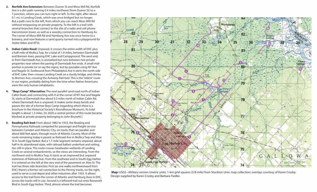
2. Norfolk Ave Extension: Between Duerer St and Moss Mill Rd, Norfolk Ave is a dirt path running 0.4 miles northeast (from Duerer St) to a T-junction, where you can turn right or left. To the right, after about 0.1 mi, is Landing Creek, which was once bridged but no-longer. But a path runs to the left, from which you can reach Moss Mill Rd without trespassing on private property. To the left is a trail with several branches that connect to the site of a radio and cell phone transmission tower, as well as a woodsy connection to Hamburg Av. The corner of Moss Mill Rd and Hamburg Ave was once home to a brewery, and now features a sand quarry turned into a playground for motor bikes and ATVs.
3. Indian Cabin Road: Unpaved, it crosses the entire width of EHC plus a half-mile of Mullica Twp, for a total of 1.9 miles, between Darmstadt and Bremen Aves, passing EHC Lake and Campground. The west end, in from Darmstadt Ave, is unmarked but runs between two private properties near where the paving of Darmstadt Ave ends. A small mid-portion is private (or so say the signs), but by-passable using NY Ave and Nagele St. Eastbound from Philadelphia Ave it skirts the north side of EHC Lake, then crosses Landing Creek on a sturdy bridge, and climbs to Bremen Ave, crossing the Antwerp Rail-bed. This is the “oldest” route in our region, probably dating from the time when Native Americans were the only human inhabitants.
4. “Boys Camp” Alternative: The next parallel sand road north of Indian Cabin Road, and connecting with it at the corner of NY Ave and Nagele St, starts at Darmstadt Ave about 0.3 miles north of Indian Cabin Rd, where Darmstadt Ave is unpaved. It makes some sharp bends and passes the site of a former Boys Camp (regarding which there is a brochure in the Historical Society’s Roundhouse Museum). Its total length is about 1.3 miles. [In 2020 a central portion of this route became blocked as private property belonging to John Brunetti.]
5. Reading Rail-bed: From about 1882 to 1933, the Reading and Pennsylvania Railroads competed for passenger and freight service between Camden and Atlantic City, on tracks that ran parallel, and about 600 feet apart, through much of Atlantic County. Most of the route remaining today is paved: as Railroad Ave in Mullica Twp and Aloe St in South Egg Harbor. But a 1.7-mile segment remains unpaved, about half in its abandoned state, with railroad ballast underfoot and rotting ties still in place. The route crosses headwater wetlands of Landing Creek on several embankments, so the views are interesting. From the northwest end in Mullica Twp, it starts as an improved but unpaved extension of Railroad Ave. From the southeast end in South Egg Harbor it is entered on the left at the very end of the pavement on Aloe St. The trail has three side-branches: First (as one walks northwestward from EHC) there’s a former rail connection to the Pennsy tracks, on the right, used to serve a coal depot and other industries after 1933. It allows access to the trail from the corner of Atlantic and Hamburg Aves in EHC, across the tracks still in use. Second is a leftward trail out onto Roosevelt Blvd in South Egg Harbor. Third, almost where the trail becomes
Map: USGS –Military version (metric units: 1-km grid squares (5/8 mile) from Stockton Univ. map collection; overlays courtesy of Karen Crosby. Design supplied by Karen Crosby and Barbara Fiedler.