6 meeting of the international argo science team6th meeting of the international argo science team...
TRANSCRIPT

1
6th meeting of the
International Argo Science Team
IFREMER, Brest France
March 9-11 2004

2

3
Contents
1. Welcome and introduction 12. Introduction to IAST-6. 1
2.1 Action items from AST-5 13. Status of Implementation 2
3.1 EEZ concurrence 23.2 Float stickers 33.3 Float failures 33.4 Regional implementation 33.5 Sampling strategies 43.6 Law of the Sea (ABE-LOS) meeting 5
4. Argo delayed mode quality control workshop 55. Argo technical issue 9
5.1 Float performance and reliability 95.2 Oxygen sensors 12
6. Performance of Argo data system 136.1 Real-time data flow 136.2 Delayed-mode data flow 146.3 Argo data products 14
7. Argo data use 158. Argo as an integral part of GOOS and GCOS 169. Assessing Argo science 1710. Broadening Argo 1811. Argo infrastructure support 1912. Argo communication 2013. Future meetings 2014. Membership changes 2015. Closure of meeting 21
Appendices1. Agenda A1-12. ` Attendance list A2-13. National reports
Australia A3-1Canada A3-3China A3-7France and EU
A3-10Germany A3-18Ireland A3-21Japan (Separate PDF file)Netherlands A3-22Spain A3-23UK (Separate PDF file)USA (Separate PDF file)
4. Global commitments table A4-1

4

1
1. Welcome and introduction.
Dr Yves Desaubies welcomed the members and other attendees at the meeting onbehalf of the Director of IFREMER. He briefly explained the structure of IFREMER andin particular the Centre de Brest. He detailed the local arrangements for the meetingand thanked Francine Loubrieu for her help in meeting planning.
2. Introduction to IAST-6.
Dean Roemmich, chairman of the IAST welcomed attendees and briefly reviewed thestatus of Argo. He particularly noted the rapid progress in implementation made overthe past year with over 700 floats deployed despite the hiatus caused by the need towithdraw SBE salinity sensors in order to replace the defective Druck pressure sensors.This meant that there was a backlog of floats waiting for deployment and that a rapidincrease in numbers would occur in early 2004. By the end of the year the array will bein a sense global following efforts to populate the Southern hemisphere oceans.However he noted that the hemispheric imbalance continued with only 400 floats neededto complete the Northern hemisphere array but 1500 needed for the S Hemisphere.
The challenge for the AST is to adapt to the rapidly maturing float array. Specific issuesthat would be considered at IAST-6 would be to take the steps needed to:
• Implement effective delayed-mode QC procedures.• Commit floats to the Southern Hemisphere.• Create deployment opportunities to increase the array density.• Demonstrate the value of Argo in operational applications.• Produce an efficient and stable infrastructure.
In order to reflect those new priorities it should be noted that the Argo Executive group atits meeting the previous day had concluded that the IAST should change its name to thebe the Steering Team rather than the Science Team since science would be only part ofthe group’s remit that would include oversight and guidance of implementation and ofArgo data use.
1. With effect from IAST-6 the International Argo Science Team will become theInternational Argo Steering Team to reflect the IAST’s wide responsibilities.All Argo participants should take steps to reflect this change in their web sitesand literature.
APO and contributing countries
2.1 Action items from AST-5John Gould then noted that there were three action items from IAST-5 that had not beencompleted and about which AST-6 should make a decision.
The first, (Action item 15), concerned collating information on the best float deploymentpractice. Groups deploying floats had been asked to send details of their deploymentinstructions to Argo Director together with information on rates of early (1 cycle) failures.It was agreed that reduction of early failures must remain a high priority and that theArgo Director and AIC should hold information on deployment methods for each floattype from research and commercial vessels.

2
2. AD and ATC to collect information on float deployment practice so that newgroups will be able to be advised on how to reduce deployment failures.
Action AD/ATC
The second, (Action item 16), concerned the collection of temperature, salinity (andpressure information) during a float’s submerged drift phase. The information requestedfollowing IAST-5 was presented by Uwe Send under agenda item 5. He concluded thatsuch data collection was possible for APEX and PROVOR float types. Dean Roemmichalso confirmed that SOLO floats could also collect such data. The energy penalty iscomparatively small (1 sample is approx 1/1000 of a the energy needed for profiling).Both Uwe Send and Yves Desaubies confirmed that pressure data provided a usefuldiagnostic of float performance. Sylvie Pouliquen confirmed that the Argo data formatswere capable of handling the drift data.
In discussion, concerns were expressed that infrequent data would be contaminated byinternal wave noise and that collecting and averaging more frequent observations wouldimpose an unacceptable energy penalty. Following discussion it was recommended thatfloats should collect P, T and S data
3. Float deployers are requested to program new floats to collect pressure,temperature and salinity data during their drift phase.
Action. All float deploying groups.
The final remaining issue concerned the recommendation to adopt 1000db as astandard submerged drift level so as to ensure that velocity data can be compiled toproduce velocity fields comparable with those constructed during WOCE. It was notedthat the universal availability of a park-and-profile capability now reduced theadvantages of choosing deeper drift levels at high latitude in order to reach stable watermasses. The standard 1000db recommendation was adopted with the proviso thatexceptions were permissible if that level was likely to result in too rapid dispersion of thefloat array.
4. Argo recommends that unless there are overriding scientific reasons tochoose another level, 1000db should be chosen as the drift level for all floats.
Action. All float deploying groups.
3. Status of Implementation.
3.1 EEZ concurrenceMathieu Belbéoch briefly summarized the status of the global array and reiterated thepoints made by Dean Roemmich. He showed a map giving the status of EEZconcurrence and noted that few countries have fully concurred but that there had beenonly one instance of a country expressing interest in the entry of a float to its EEZ (aCanadian float entering Russian waters). It was commented that the map that isavailable on the AIC web site is not accurate (particularly in showing the UK EEZcompliance). Two action items were agreed
5. ATC to correct errors in the EEZ concurrence map and to ensure that allcorrespondence associated with concurrences is held by AIC.

3
Action. ATC6. All Argo contributing countries to take steps to implement EEZ concurrence
before IAST-7Action. APO to approach Argo national contacts.
Mathieu Belbéoch noted that the use of IOC stickers on floats had increased to 50% onfloats deployed in 2003 (20% in 2002) and that it will greatly simplify the identification offloats picked up at sea or washed ashore if they have stickers. Dean Roemmichconfirmed that SIO had not yet completed trials to identify if stickers can becomedetached from SOLO floats.
3.3 Float failuresMathieu Belbéoch went on to highlight that detailed metadata needs to be compiled if weare to be able to document and investigate failures of floats within the global arrayincluding failures immediately after launch. Sylvie Pouliquen noted that most of thisinformation was already held by the Coriolis data center, by the AIC or by Steve Riserand needed to be integrated (at Coriolis).
7. ATC and AD to identify a full set of metadata relating to float shipping anddeployment conditions so that potential causes of early failures of floatperformance may be identified. These should then be incorporated in astandard deployment form.
Action. AD and ATC.
3.4 Regional implementationDean Roemmich showed the basin implementation maps and invited the comments onthe plans from the regional co-ordinators. He noted that Southern Ocean deploymentplanning had not been very active and suggested that in future the Southern Oceanshould be included in the Atlantic, Pacific and Indian Oceans using the longitudinalboundaries agreed at AST-5. This was agreed.
8. Atlantic, Pacific and Indian Ocean deployment co-ordination to include theSouthern Ocean region with boundaries set at 20°E, 145°E, 70°W.
Action. Pacific, Atlantic and Indian Ocean co-ordinators
The deployment plans for the Pacific, Indian and Atlantic Oceans were discussed. Itwas noted that there were plans for repeated deployments in the Drake Passage byKorea. In the Atlantic it was noted that the map was not complete since the plans forCanada, Germany, Ireland and the Netherlands had not been incorporated. Theopportunity presented by the twice-yearly UK- Falklands Atlantic Meridional Transect(AMT) was seen as a valuable means of seeding the S Atlantic. The Atlantic planningweb site maintained by Coriolis will soon incorporate links to the national text files as isdone on the Pacific site.
Two sites are maintained for the Indian Ocean, at CSIRO and INCOIS. These do not atpresent show the same information. They will be synchronized by April. It isrecommended that the Indian Ocean site(s) should also incorporate text files. KopillilRadhakrisnan noted that the implementation strategy for the Indian Ocean was in largepart driven by IOGOOS and by CLIVAR. He commented also on the excellentcontribution that had been made by the Mirai during her round the world voyage indeploying floats in the mid-latitude Southern Hemisphere.

4
Yves Desaubies noted that it was often difficult to identify when a planned deploymenthad been carried out and that this required a feedback process from the deployingcountry/lab to the co-ordinator. It was recommended that this should take place and thatplans should be updated at least twice per year.
9. APO to send reminders to countries in January and July to update theirdeployment plans. Float providers are encouraged to submit plans morefrequently if appropriate.
Action. APO
Etienne Charpentier commented that the deployment of surface drifters might alsopresent opportunities for float deployments (and vice-versa ) and suggested that stepsshould be taken to identify possibilities for ship sharing.
10. ATC/JCOMMOPS co-ordinator to take steps to integrate information on floatand drifter deployment opportunities.
Action. ATC
It was also commented that from the viewpoint of planning of the buildup of the Argoarray it would be valuable if in the global commitments table compiled by Stan Wilson(Appendix 4), countries could indicate the number of floats that they expected would bedeployed south of say 20°S.
11. APO to contact countries and ask how many floats they were committing toregions south of 20°S.
Action. AD
It was noted that Argo depended on the willing co-operation of many research andcommercial ships to deploy floats and that this help ought to be recognized.
12. APO to design a certificate to be presented to ships and aircraft that havemade exceptional contributions in deployment of Argo floats.
Action. AD
13. Argo float deployment groups to give APO the details of ships whosedeployment contributions merit special recognition. (Ship name, call sign,number of floats deployed, dates, contact details).
Action. All float deploying groups
3.5 Sampling strategiesThere followed a general discussion of the concerning the desirability for samplingstrategies that differed from the standard 10 day profiles to between 1000 and 2000mand 1000m parking depth. Such alternative sampling strategies were driven by regionalpriorities for the study of particular phenomena. (e.g. in the Mediterranean a 350m cruisedepth and 5 day cycle, more frequent sampling and shallower profiling are needed ifmodes of variability on the low latitude Indian Ocean are to be resolved). It wasconcluded that such sampling should be done by Argo equivalent floats deployed inaddition to the “standard” global array and that a letter to that effect should be sent toCLIVAR.

5
14. Letter to be sent to CLIVAR SSG reiterating ARGO’s priority to complete theglobal array with “standard” 10 day cycling floats and to stress that morefrequent sampling if needed in the short term must come from additionalArgo-equivalent floats.
Action. AD
3.6 Law of the Sea (ABE-LOS) meetingStan Wilson then described the working of the Advisory Body of Experts on the UNConvention on the Law of the Sea (ABE-LOS) that would meet in Greece May 4-7 2004.ABE-LOS was established by the IOC to provide guidance regarding the application ofthe Law of the Sea to IOC activities. IOC Resolution XXII-12 requested ABE-LOS “toprovide advice on the legal framework within the context of UNCLOS which is applicablefor the collection of oceanographic data”. Thus the deliberations of ABE-LOS –IV thatwill design a framework for the conduct of operational oceanography within EEZs aredirectly relevant to Argo.
The key issue is whether the deployment and operation of Argo floats is MarineScientific Research (MSR) and thus requires application 6 months ahead of time todeploy floats in a country’s EEZ or whether the operation of Argo floats is more akin tothe routine collection of meteorological data that does not require such notification. Theexemption of the met data is on the basis of their value for issues relating to safety of lifeat sea. (The IOC Resolution concerning Argo only addresses advance notification of thedeployment of floats on the high seas by one country that might subsequently drift intoanother country’s EEZ. It does not address the deployment within another country’sEEZ. Even so, an IOC Resolution does not necessarily have the approval of the ForeignAffairs Ministry or Navy of a given country).
We need to make the make an argument on behalf of Argo, based on the potential utilityof the resulting data.
15. AST members are asked to identify who will represent their country at ABE-LOS-IV and explain to that person present and potential new benefits to yourcountry by helping expedite the collection and timely sharing of Argo andother oceanographic data from within your EEZ .
Action. IAST members.
4. Argo delayed mode quality control workshop
In introducing the workshop Dean Roemmich remarked that much progress on Argodelayed-mode realm had been made in the 12 months since AST-5 in Hangzhou: Argonetcdf Version 2, regional improvements, etc. It was therefore timely for AST-6 todiscuss the PI’s role in the delayed-mode process. This needed to be done bearing inmind that there should be a delayed-mode procedure for each parameter measured bythe floats: pressure, temperature and salinity.
The DM QC workshop was started with a presentation on “Temperature and salinityanalysis over the Atlantic in real time - Qualification of measurements” by EmmanuelleAutret and Fabienne Gaillard. They concluded that their operational system producingRT T & S fields over the Atlantic (global ocean by the end of 2004) could be considereda quality control tool by identifying outlying floats. Constant (over depth) salinity offsetscan be estimated within 0.01 psu but in the case of time varying offsets one must still

6
decide whether it is due to the analysis (inconsistency with climatology) or to sensor drift.Each case must be looked at individually and compared with other methods - hencereinforcing the role of the PI. In collaboration with L Boehme, E Autret has shown thatthe estimations of the offset and drift made using this method were coherent with LarsBoehme estimations in Atlantic Ocean.
The initial float calibration is a key element in both real time and delayed mode QC. Thiscalibration may be made in the laboratory prior to dispatch to the deploying vessel oraircraft or it may be in the form of a CTD station worked by the deploying researchvessel. A number of presentations (Desaubies, notes from Riser and comments fromKing), were made demonstrating the value of these two calibration activities. Laboratorycalibrations enabled salinity sensors with unusually large offsets to be identified and ifnecessary replaced. Uncertainties in at sea comparisons with shipboard profiles comefrom the time delay between deployment and the first profile and by the spatialseparation resulting from this delay. This could be reduced if a float were programmedto execute an up profile within 1 day of launch. Yves Desaubies has also shown thatthese estimations of offsets made both at laboratory and from CTD were compatible withthe ones calculated from statistical methods that are agreed for delayed mode QC.
16. It is recommended that the salinity sensors on all Argo floats should besubjected to a laboratory check of the CTD sensor calibration.
Action. All float deploying groups.
17. It is recommended that floats should be programmable to execute a CTDprofile within 24 hrs of deployment. APO to consult with manufacturers tosee if this can be easily implemented
Action. All float deploying groups.
The workshop continued with presentations by Lars Boehme on IfM, Kiel’s experiencewith DM QC in the subpolar N Atlantic within the Gyroscope project, by Shinya Minatoon JAMSTEC’s experience in the N Pacific and by John Gilson on a graphical userinterface for the edit of individual profiles and data points.
Annie Wong summarized the current state of the delayed mode QC process byremarking that much progress on the Argo delayed-mode realm had been made in the12 months since AST-5 in Hangzhou: Argo netcdf Version 2, regional improvements,etc. It was therefore timely for AST-6 to discuss the PI’s role in the delayed-modeprocess. This needed to be done bearing in mind that there should be a delayed-modeprocedure for each parameter measured by the floats: pressure, temperature andsalinity. This workshop discussed delayed-mode procedure for salinity only. Amongst theinstrument errors found in float salinity measurements, this workshop concentrated onsensor-related drifts and offsets. The PI should be aware that there are other instrumenterrors in float salinity measurements such as anomalous salinity spikes that areassociated with areas of sharp thermal gradients.
For salinity, there are two parts to the Argo delayed-mode process: The first is a semi-automatic procedure for identifying artificial drifts and offsets, where the methods usedare repeatable, documented, and have quantified uncertainties. (This is based on WJO,2003 or Boehme, 2003). In cases where ambiguities still exist, this then needed to be

7
followed by a more subjective procedure for identifying more subtle errors. This involvesinspection of individual profiles by PI/expert. The purpose of the workshop is to attemptto introduce some uniformity to the subjective PI/expert part.
The role of the PI in the delayed-mode process is to determine the stability of the floatdata. This would involve
•Determining that the reference database is adequate for the region sampled bythe floats with the help of regional data centres..
• Determining that the statistical method used is appropriate for the region.• Determining that the statistical uncertainty levels are realistic.• Determining whether the drifts and offsets identified by the semi-automatic part
are artificial and not due to ocean events, or determine that the float is stable.• Determining other instrument errors, other than artificial drifts and offsets.• Estimating a correction, or concluding that the float measurements are good. In
both cases, determining an error bound.
This subjective PI element of the QC process is needed because there is no “absolutereference”, and because new instrument errors are still being discovered. This lack ofabsoluteness is because
• The semi-automatic process cannot distinguish water mass boundaries, fronts, etc.,and most importantly, signatures of ocean events such as eddies, interannual variability,and decadal changes.• Other than artificial drifts and offsets, there are more subtle instrument errors to beidentified, e.g. salinity spikes associated with sharp thermal gradients.• A PI brings in expert information on the float instrument type, local oceanographyknowledge of float sampling area, and other recent and close-by data.• Departure from traditional calibration: float delayed-mode calibration has no “absolutereference”. Hence it requires a new kind of thinking: one that synthesizes climatologicalanalysis and climate change analysis.
She hoped that the workshop would provide some basic guidelines for PIs. So far theonly agreed guideline is not to correct any drift or offset that is less than 2 x statisticaluncertainty or instrument precision, whichever is greater. This means that Argoconsiders that a float is stable if its measurements deviate from climatology by less than2 x statistical uncertainty or instrument precision. An issue for the workshop is “Do wewant to put a ceiling on the statistical uncertainty?” Also, there are ocean events that candeviate from climatology by more than 2 x statistical uncertainty. If a float samples theseevents, it doesn’t mean that it wasn’t stable. What are some examples of these oceanevents? How do we identify them? What do we quote as error bars for these events? Ifthe float data are good but the local statistical uncertainty is large and we quote that asthe data accuracy, we will turn the signal into noise.
The workshop should also suggest how delayed-mode calibration experiences can beexchanged, for example by establishing an email subscription list or be establishingregular discussions on the topic at AST and ADT meetings?
The best practice needs to be spelled out in the Argo Delayed-Mode QC Manual. She

8
stated that she hoped to have Version 1 on the GDAC sites by end of March. Thisrequired agreement on its contents. There were still some unresolved technical issuesthat need AST input: For instance
• Is the criterion of max [2 x statistical uncertainty, instrument precision]acceptable? Do we want to put a ceiling on the statistical uncertainty? What dowe put down for PSAL_ADJUSTED_ERROR when the data are good?• Should we correct a series (trend) or should we correct individual profiles?• A sliding window needs to be used when correcting series. What should thelength of that window be?• A set of conventions needs to be established for assigning salinity delayed-mode qc flags PSAL_ADJUSTED_QC = 1, 2, or 3. Do we want to use these todenote quality of dm adjustments, or do we want to use these to flagmeasurements that have been through real-time qc and delayed-mode qc, butare suspicious according to PI?
The following are the agreed actions for delayed-mode salinity drift correction
18. The basic criterion for delayed-mode qc of float salinities is to not adjust floatsalinity data that are within max [2 x statistical uncertainty, _ x instrumentresolution and precision/reproducibility].
Action. All groups doing DM QC.
19. For drift correction, the parameter PSAL_ADJUSTED_ERROR shall containthe value of max statistical uncertainty, _ x instrument resolution].
Action. All groups doing DM QC.
20. Where float salinity data have been subjected to multiple corrections, e.g.drift correction + spike correction, that the PI shall attempt to propagate errorsfrom all steps, and record the final value in PSAL_ADJUSTED_ERROR.
Action. All groups doing DM QC.
21. Agreed that in the absence of expert intervention, delayed-mode driftcorrection shall involve the estimation of an offset and slope over a window oftwelve months (that is 6 months before and 6 months after the profile, i.e. anew linear fit over 12months is estimated for each profile, which assures thecorrections vary smoothly from profile to profile). This means that in general,the timeframe of availability of drift-corrected delayed-mode salinity data is 6months after a profile is sampled.
Action. All groups doing DM QC.
22. In order to gain experience in delayed-mode processing and to beginreducing the backlog of profiles, it was agreed to process data in orderstarting with non-controversial data (no drift or drift adjustment accepted),followed by data requiring subjective decisions.
Action. All groups doing DM QC.

9
23. Argo shall begin to issue drift-corrected salinity delayed-mode data that havePSAL_ADJUSTED_QC = ‘1’ and ‘4’. The flags ‘2’ and ‘3’ shall be used to flagfeatures such as spikes and upper ocean anomalies in the adjusted profile.
Action. All groups doing DM QC.
24. A delayed-mode email list will be set up by Thierry Carval, with Breck Owensas moderator, for compiling a list of instrument failure modes that warrantusing PSAL_ADJUSTED_QC = ‘2’ and ‘3’, and for designing proper codes forrecording these failure modes in the HISTORY section of the Argo netcdffiles. This email list is also to be used for general discussions related todelayed-mode processes. All PIs are encouraged to subscribe to this emaillist by contacting Thierry Carval.
Action. Carval and Owens.
25. Annie Wong will finalise Version 1 of the Argo Delayed-Mode Manual basedon all agreements from this workshop, and put it on the GDAC websites. Thismanual will be expanded to include additional sections (such as regionalspecifications, instrument failure mode list, difficult calibration examples, etc)as delayed-mode experience within the community grows.
Action. Annie Wong.26. Agreed to apply estimates of offset and slope to realtime data in cases
where this is unambiguous and significant. This should come either from pre-deployment calibrations/deployment CTD casts, or from the most recentdelayed-mode salinity corrections. Details remain to be agreed by BreckOwens, Annie Wong , Uwe Send and Yves Desaubies .
Action. Wong, Send, Owens, Desaubies.
The workshop concluded by noting that Argo is now the primary source of open-oceanprofile data. Calibration by reference to a static climatological database will becomeincreasingly inadequate. This is especially true for the Southern Ocean, where the bestavailable measurement will be an Argo profile that has been judged to be stable.Research and development of methods of calibrations by using nearby stable float datain a semi-automatic manner should be stimulated as should be the collection and rapiddissemination of ship-based high quality CTD data that would need to be quicklyassimilated into the climatologies used.
5. Argo technical issues
In introducing this agenda item, Dean Roemmich commented that the key issue was todemonstrate that float performance was improving to a level at which we could havesome certainty of the date at which the full Argoo array would be completed.
5.1 Float performance and reliabilityHe started by presenting a report on the SOLO-II floats that have been deployed sincelate 2002 following design improvements included changes in the pumping system, limitswitches, and air bladder and a new CPU. 96 re-designed SIO SOLO floats weredeployed in the period October 2002 – November 2003. 60 more have been shippedand/or deployed since November 2003. Of the 96, 91 are still active. 2 failures were dueto air bladder (1@8 cycles, 1@10 cycles), one was due to a pressure sensor failure at30 cycles, and one to grounding at 30 cycles. A further float failed for unknown reasons

10
at 8 cycles.
This means that the cycle completion rate (actual cycles to date/ potential cycles) to dateis 98%. Performance figures for SOLO-II floats built by WHOI are similar. Furtherimprovements to the air bladder are planned.
He then showed a presentation prepared by Steve Riser who was unable to attend themeeting. The information was based on the performance of 489 WRC Apex floats in 9countries that have allowed RT access to Argos messages so that engineering and otherdata can be monitored and analysed.
The most important problem inherent to Apex that has been fixed in the past year is themotor backspin problem that affected floats with a deep parking depth (see table below).This problem was discussed in detail at IAST-5. The problem was corrected byintroducing the APF-8C version of the Apex controller. No floats deployed in the pastyear with the APF-8C have shown the motor backspin problem. This is encouraging,since most of the floats that showed the problem failed within 10 profiles afterdeployment.
Group Samplesize
Profiles executed Profilesexpected
Reliability (%)
Apex 180 20 1234 2033 60.7Apex 260 468 22672 28659 79.1
APF5 1 17 17 100.0
APF7 58 3292 5997 24.9
APF8 427 20576 24638 83.5APF8,Park<1400m
253 11854 13189 89.9
APF8,Park>1400m
177 8760 11506 76.1
APF9 3 38 57 66.7R1 1 17 17 100.0Total 489 23923 30709 77.9
Reliability statistics for WRC Apex floats covering the period July 1 1999 to March 92004
The statistics for APF-8C controllers are not reflected in the table since until recentlystatistics were not kept separately. However, UW APF-8C (parking < 1400 m) have hadno failures due to the motor backspin. Many of these floats have completed more than50 profiles. A check of floats parking at deeper levels (i.e. 2000 m) also shows nofailures due to backspin after use of the APF-8C controller was initiated.
Early reliability of Apex floats can be seen to be considerably lower than for the presentgeneration. The APF-7 and early versions of the APF-8 controller were only roughly50% reliable. In practice, this meant that many floats failed during their first year in the

11
water. Present reliability of all 427 floats with APF-8 controllers (including the originalversion and variants A, B, and C) show 83.5% reliability. With 24638 profiles executedby 427 floats, this yields an average time in the water at present of about 58 profiles, orover 18 months. It seems we are beginning to approach the 90% number that is thestated goal of Argo.
However two new problems have been recognized in the past year. The first manifestsitself as a rapid decline in battery voltage after about 100 profiles. This has been tracedthrough the recovery of floats and to long-term pulse discharge tests to poor alkalinebattery pack construction. This means that if a single cell fails it will result in the failureof the remaining cells.
There are two possible solutions. The first that has been instituted by WRC is to addprotective diodes to each cell. The second more radical solution would be a move tolithium battery packs. This has the double advantage that lithium batteries are morereliable than alkaline cells and that they have greater energy density. (Note there areconcerns that as other float failure modes are eliminated it may be clear that the alkalinebattery packs in Apex float will be found to have insufficient capacity to complete therequired 140 profiles). There are penalties to using lithium batteries. The added cost isabout US$500 per float. In addition there are restrictions to shipping lithium batteriesthat will become more stringent before the end of 2004. Because of this secondlimitation WRC has opted not to supply floats with lithium batteries. UW intend toeventually change to lithium on all floats. At present they have designed their ownlithium battery packs and have now deployed 5 of these floats. UW will use diode-protected alkaline batteries only where shipping restrictions prevent us from usinglithiums.
It was noted that SOLO floats use lithium batteries and that there have been noproblems encountered with shipping these provided the regulations are closely adheredto.
27. APO should compile as much information as is available on the shipping ofinstruments containing lithium batteries in order to engage in informeddialogue with WRC on the subject.
Action. APO.
The second potential cause for float failure came to light through the recovery of twoApex floats that had run aground. In each of these several tens of grammes (dry weight)of sediment had become trapped in the cowling covering the bladder. This cowling hasmore holes that are required to allow the bladder to expand and contract freely.
28. Recommend that float users block all but a single hole in the bottom cowlingof Apex floats and that WRC be asked to change the design to eliminatesediment pickup by grounded floats.
Action. All groups preparing APEX floats and WRC.
Nobie Shikama then presented a report on JAMSTEC’s experience with both Apex andMetocean PROVOR floats. They had experienced the same Apex failure modes asreported by Steve Riser. For a sample of 27 Apex floats that had failed 37% showedabrupt battery failure, 37% were attributable to the Druck pressure sensor problem on

12
the SBE salinity sensors, 11% were due to grounding and the remaining 15% hadunknown causes. He went on to show how floats had been recovered at sea andpointed out the value of inspection of recovered floats.
He went on to describe a prototype NINJA floats fitted with a chlorophyll sensor and anexperiment under the Arctic icecap using an Argo float profiling on a mooring.
Gerard Loaec then reported on the performance of floats used in both the French Argoprogramme and the European Gyroscope project. He noted that Metocean in Canadawere no longer manufacturing PROVOR floats but that they would remain as agents forMartec/SERPE – manufactured floats.
In the Gyroscope project 40 Martec Provors and 44 WRC Apex floats were deployed inmid 2001. Seven of each type had ceased to work in the past year leaving 28 Provors(70%) and 33 Apex (75%) still active. This means that overall each float type hasdelivered about 85% of the maximum data possible.
Technical improvements during the past year have included the rectification of the faultthat caused many Metocean floats deployed by Jamstec to execute an ‘emergencyascent’ in which the float surfaces without waiting for the end of the cycle if the pressureindicated is higher than the maximum allowed pressure. Most of the floats die between70 and 90 profiles without the experience of emergency pop-ups. (Japanese NationalReport) with a parking depth of 2000 dbars. To cure this the software has been updatedon all floats to control the float at depth. It also seems that the quality of the valve on thehydraulic engine is not stable and that low leakages inside the hydraulic circuit mayhappen. All floats have been fitted with a new valve (PSA) since the end of 2003.
A second fault on some Kordi floats is that they don’t dive when the surface watertemperature is low. This fault has now been rectified.
PROVOR flots have been deployed with both FSI and SBE salinity sensors. The FSIsensors have shown erratic behaviour that has been attributed either to interference bythe damping plate with the external field of the salinity sensor or to fouling. The dampingplate has been moved further away and some more floats were deployed in the southernocean (cold water) at the beginning of 2004. Most PROVOR floats are now beingdeployed with SBE sensors but efforts continue to solve the problems with FSI.
Finally a new float has been designed by IFREMER (it was on display in the meetingroom). It is lighter (19kg) than present floats, is designed to do 100 cycles to 2000m inall oceans, it has 800ml variable buoyancy and does not require ballasting.
5.2 Oxygen sensors and other measurementsFinally in this session updates were given by Uwe Send and in a report from Steve Riseron the latest status of oxygen sensor developments. Send showed data from two floatsin the Labrador sea that use the Aanderaa optode probe in which the optical propertiesof a membrane respond to oxygen concenration. The sensor has a fast (30 second ?)response time and is immune from biological fouling. The results seem very promisingwith good agreement between the two floats when they were close togather andbetween float and ship data. The values recorded are consistent with expectedsaturation values in the upper mixed layer.

13
The Riser report showed data from floats in the North, Central and South Pacific withtime series varying in length from 22 to 52 profiles taken at 10 day intervals. For eachfloat the dissolved O2 profiles were compared to historical data in the WOA2001 archive.All stations in the archive in a 3° box around the trajectory having T, S, p, and O2 datawere averaged onto σθ surfaces for comparison with the measured σθ − O2 relation. Thiscomparison is sometimes difficult due to the relatively poor climatology of dissolved O2.
Results suggest that the SBE-43 oxygen sensor is very promising for measuringdissolved O2 from profiling floats over times of several years. Historically, the mainproblem with polarographic Clark-type O2 sensors has been excessive drift over time.This problem seems to have been greatly reduced with the SBE-43. Several lesssevere problems remain to be solved with the SBE-43, and it appears that it willeventually be a useful tool for scientific research.
The potential of Argo floats to make other measurements nearer to the ocean surfacethan is presently possible was discussed. They might be used in the GODAE HighResolution SST Pilot Project and for calibration of satellite salinity sensors. It was clearthat there would soon be pressure on Argo floats to make such measurements.
29. AD to prepare a document outlining the potential for making measurementsother that T and S from profiling floats.
Action. AD
It was suggested that the present method of calculating float reliability as actual profilesmeasured / maximum possible profiles measured did not fully reflect performance andthat other statistical measures that take into account the expected float lifetime shouldbe developed.
It was noted that SBE had moved very quickly to rectify the fault in the salinity sensorsand they should be thanked for this effective action.
30. AD to write to Nordeen Larsen (SBE) to thank him and his company for thespeedy action to rectify last year’s pressure sensor problem and for theirclose co-operation with float providers to minimize its impact.
Action. AD
6. Performance of Argo data system
Sylvie Pouliquen presented a summary of data management activities within the pastyear. There has been a change in the leadership of data management team: Bob Keeleystepped down from this position last November and M Ignaszewski has accepted toreplace him as a co-chair of ADMT.
31. AD to write to thank Bob Keeley for his work as ADMT chairmanAction. AD
6.1 Real-time data flowThe real-time data flow is now in a pre-operational stage and 90% of the data arearriving at GDAC through the DACs. The percentage of data arriving solely through GTShas decreased from 30% to 10% in accordance with the goal set by the ADMT. Thisshould be reduced around 5% by the end of 2004, with the setting up of new DACs

14
(Korea, India), the collaboration between CORIOLIS and CLS-France for the dataprocessed by CLS, AOML and NAVOCEANO for USA. Work is underway to retrievepart of the historical data (starting 2000) received only by GTS.
About 80% of data are now available on the GTS within 24h. since CLS has justdecreased the delay before starting GTS processing the data from 25 to 18 hours andwe have seen an improvement at French node through the automation of the QC atCORIOLIS.
6.2 Delayed-mode data flowCompletion of the delayed mode data stream is the 2004 challenge for datamanagement. A few DACs are setting up the system and were waiting both for theimplementation of Version 2.1 of Argo data (which is able to handle adjusted-parameters) and the guidance from IAST-6 to start (see delayed mode section). Ourgoal is to have the first delayed mode data available at GDACs in mid 2004.
The setting up of RDACs (regional DACs), is not a priority for 2004 since we first need tohave delayed mode data of uniform consistency on a basin-wide scale, and productscan then be built from this. BODC mentioned that the RDAC they will establish will dealwith data from the Atlantic and Indian sectors of the Southern Ocean but not the Pacificsince they have no expertise in that region. A decision needs to be made whether thePacific sector of the S Ocean should it be included in the responsibilities of the PacificRDAC?
6.3 Argo data productsIn the remit of the ADMT there is an issue (led by Bob Molinari) dealing with twocategories of products based on Argo data. The first, concerns the statistics that definethe development and performance of the Argo network. For this both AD and IASTshould propose examples of statistics that are precise enough to be useful but also clearenough not to be misinterpreted by readers. AD will coordinate these activities.
32 AD to suggest statistical parameters (e.g. on float reliability) that can beadopted by all Argo participants to enable the array performance to beexamined and publicised
Action. AD
The second concerns products generated from Argo data that could provide goodadvertising for Argo. AD should propose a set of criteria to define the products that couldbe than linked from AIC www site.
33. AD to establish a set of criteria to be used in assessing whether a product isappropriate to be used to advertise the benefits of Argo
Action. AD
One product that can be produced from Argo data, is the velocity information derivedfrom trajectory files. Kuh Kim will lead the definition of such product for Argo with helpfrom experts for each float type ( Kuh Kim for Apex, Yves Desaubies for Provor, BreckOwens for Solo).
Argo’s link with operational users has to become much more active of we are to be ableto improve the service to them. Each country should organize this link at national level to

15
the DACs and that a summary of the feedback received and the effectiveness of thelinks will be made at next ADMT meeting. For operational centres directly linked to GTS,this feedback, especially on bad floats, will be returned to GDACs that will make theinterface with the DACs.
34. IAST members to take responsibility for establishing a dialogue withoperational centres in their country and report to ADMT of any problems withArgo data and its delivery
Action. IAST members
The issue of new real-time QC tests was briefly discussed including the detection ofparameter jumps, frozen profiles, and grey lists. It was agreed that the ADMT wouldpursue these changes and report progress at their next meeting.
The need for a "Cookbook" (or "Quick Start Guide") was discussed and the ADMT hasagreed to develop the document in time for review at the ADMT meeting in the fall.
Finally NODC has produced a draft of the Argo CD-ROM ; it was agreed that someIAST members would volunteer to review this new version.(http://argo.nodc.noaa.gov/cd_1 , http://argo.nodc.noaa.gov/cd_2 ).
35. IAST members to volunteer to test-drive Argo data CD-ROMAction IAST members
The goal is to finalise the master end of June 2004. The distribution list should beprovided by AD to NODC as soon as possible.
36. AD to compile a list of recipients for the first Argo data CD-Rom and passthis to NODC by 1 May 2004
Action AD
The next Argo Data Management Meeting will be in Southampton, UK the 29-30September, 1st October 2004.
7. Argo data use
John Gould reported that clear evidence of the widespread use of Argo data was givenin the presentations from last November’s First Argo Science Workshop in Tokyo. Theapplications ranged from the study of the interactions of tropical cyclones with the upperocean thermal structure to the study of decadal change in the ocean and the calculationof the global heat storage. These applications by and large were being carried out inresearch institutions.
Since the real time data stream was at present the most complete we were in a positionto review the use of these real time by operational analysis and forecasting centres. Hesaid that he had constructed a table (Table 1) showing which centres were using thedata and for what purpose. It was important that Argo maintained an active dialoguewith these centres with a view to a) receiving feedback on any problems theyencountered with the data delivery and quality and b) Argo being able to cite the use of

16
the data to reinforce the importance of Argo to national funding agencies. Insert RT datause table here
It was decided that the table should be maintained by the APO and enlarged asappropriate. Primary responsibility for maintaining this dialogue should be with themembers of the IAST (Action item 33)
8. Argo as an integral part of the Global Ocean and Climate Observing Systems
John Gould introduced this item by stating that while Argo was concentrating onpursuing its own objectives, it was important to recognize that Argo was a key element inthe ocean and climate observing systems and that it was now the major source of oceanprofile data on which many applications depended. This fact was encapsulated in atable that he had prepared for the meeting of POGO (The Partnership for Observing theGlobal Ocean). This table had since been used by POGO as evidence to the GlobalEarth Observations (GEO) system of the importance of ocean observations in definingthe state of the earth. GEO was in the midst of a process to define a 10 yearimplementation strategy for all types of earth observations.
In light of this importance it seemed ironic that Argo was still regarded as only a pilotproject but the term “pilot” was indicative of present transient nature of Argo funding.Members of the IAST commented that funding for virtually all elements of the oceanobserving system were similarly volatile.
Kopillil Radhakrishnan then gave resume from the perspective of IOC of the importanceof ARGO. He noted that GOOS, GCOS and the recent JCOMM are importantintergovernmental structures that have a role in shaping the Ocean observation systemsas a global design and facilitating its implementation through the Member-States. Thereare now several active GOOS Regional alliances and a Regional GOOS Council hasnow been evolved.There is a Data Exchange Policy of IOC that has been approved by the IOC Assembly in2003. The IOC Committee on International Oceanographic Data and InformationExchange (IODE) with a chain of 64 Ocean Data Centres is another structure that isimportant. Ocean Data and Information networking (ODIN) is taking place in threeregions. The IODE as well as Data Management aspects of GOOS and JCOMM aremoving in synergy. Certainly the Argo Data Management System that is very welldeveloped, has to be formally taken note by JCOMM/IODE.GOOS is now entering the implementation phase. During 2002 there was acomprehensive review of GOOS structure by a Review Group under Dr Paul Mason asordered by the IOC Assembly. An inter-sessional Working Group of IOC Assemblyrecently went through these recommendations. The suggestion regarding GOOS linkagewith Pilot Projects such as Argo is as follows:-
“GOOS Pilot Projects that are stimulated by the research community and/or GOOSCommunity (through one of its Panels) and managed by the wider scientific communitythrough independent steering committees should also become part of the overall plansfor GOOS.
GOOS should encourage and support such Pilot Projects with minimal interference but itis important that GOOS is sufficiently well informed of the successes and failures of such

17
Projects so that it can make sensible decisions about which of them should be takenforward to operational status.
The Steering Committees of such Pilot Projects do not have to be formally representedin the GOOS structure.”
9. Assessing Argo science
Kensuke Takeuchi stated that JAMSTEC the Japanese sponsors of the Argo Workshophad been very pleased with the outcome. Both the number of attendees and the breadthand quality of the science had exceeded their expectations. He noted that CD-ROMs ofthe presentations had been prepared by JAMSTEC and would be distributed. DeanRoemmich and other members of the IAST expressed their pleasure at the success ofthe workshop.
John Gould said that it was now important to maintain the visibility of Argo science andthat this would occur in a number of ways. Firstly there were an increasing number ofArgo-based papers in the refereed literature and that this was represented by the Argobibliography. He asked IAST members to help to keep this list as up to date as possible.
37. AD will remind IAST members twice yearly to submit new entries for theArgo bibliography.
Action. AD.
It was also important that papers using Argo data should acknowledge the project. Aform of words had been suggested and IAST members were encouraged to ensure thatthese were used in papers from their country.
38. Papers using Argo data should use the following words in theacknowledgement section. “ These data were collected and made freelyavailable by the International Argo Project and the national programmes thatcontribute to it. (www.argo.ucsd.edu, argo.jcommops.org). Argo is a pilotprogramme of the Global Ocean Observing System".
Action. AD and ATC to make these words prominent on the Argo web pages.
Dean Roemmich suggested that researchers should also, as a courtesy, contact PIsresponsible for floats from which they were using data to inform them of the nature of theresearch being undertaken.
38 Researchers should contact PIs responsible for floats from which they areusing data to inform them of the nature of the research being undertaken.
Action. AD and ATC to make this advice prominent on the Argo web pages.
The second means of highlighting Argo research was through dedicated workshopssuch as the one in Tokyo and through sessions at major conferences. An invitation hadbeen extended by Indonesia to host a second Argo workshop in Indonesia. A session inwhich Argo results from the North Pacific would be presented would be at the PICES-XIIIin Hawaii in October. A second opportunity would be an Argo/GODAE session at theIAPSO/IAG conference in Cairns, Australia in August 2005. These meetings were

18
endorsed by the IAST. In discussion it was concluded that the most appropriate timeand venue for a 2nd Argo workshop would be in the USA in late 2005/early 2006.
Gaël Forget presented the paper “ A 4D-Var analysis of Argo profiles in the NorthAtlantic“ by Gaël Forget, Bruno Ferron and Herle Mercier. The results show that Argoprofiles when combined with a low resolution model using 4D VAR assimilation providesa system well suited for climatic analysis of hydrology and circulation.It allows to interpolate Argo in situ data, reveals the associated circulation from aninverse calculation and describes low frequency/large scale variability, in a dynamicallyconsistent manner.
10. Broadening Argo
John Gould noted that both Ireland and the Netherlands were now Argo float deployingnations and that this was a welcome addition. One of Argo’s strengths would be in itsdiversity and with that in mind Argo should seek ways in which participation could befurther broadened. One geographical area that was under-represented was SouthAmerica. However during and since the workshop South American countries(specifically Brazil, Chile, Costa Rica and Argentina) had expressed interest in becomingactive participants in Argo. With this in mind Howard Freeland had started to developideas for a workshop in the region. He then described his ideas.
The workshop would probably be held in Chile and would be built around Canadasending two or more floats to Chile. Other countries from across S. America would beinvited to attend. The workshop would have speakers explaining how the floats work,including hands-on demonstration of the starting of a float and checking it out prior tolaunch. There might be an opportunity to discuss the technology in more detail includingdiscussion of the variety of floats available, advantages and disadvantages of differentdesigns etc. Other key elements would be showing examples of the use of Argo forData Assimilation and for regional environmental assessment and a detailed descriptionof the data system. The workshop should include discussion of international issuessurrounding Argo. The workshop might last 2 days.
It could be held in Valparaiso or Concepcion, but since the floats would be shipped toSHOA, Valparaiso seems to be the obvious option. If in Valparaiso it could be either atSHOA or at the Universidad Catolica de Valparaiso.
Members of the Argo Steering Team who attend would be expected to pay their ownway. There are indications from the IOC (through Janice Trotte in Brazil) and from theInter American Institute (IAI) that they may be willing to support the workshop withfinding to enable S American participation.
It was pointed out that CLIVAR might wish to be involved and could help with regionalorganization since they have an active (though not specifically ocean-focussed) programin the region.
Mathieu Belbeoch pointed out that Spain (Gregorio Parrilla) had expressed an interest indonating floats to the region and that they might be able to be deployed by Costa Rica.
39. Howard Freeland to work with APO to continue planning for an Argo SAmerican workshop and to seek IAST members to make a contribution to the

19
workshop.Action. APO and Freeland
11. Argo infrastructure support
Dean Roemmich, in introducing this topic, noted how Argo had addressed thedevelopment of the infrastructure it needed in a rather piecemeal and pragmatic way(this had included the formation of the ADMT, the establishment of the AIC, thedevelopment of the data system and most recently the appointment of John Gould as atemporary Argo Director.
It was now recognized that Argo would need a more formal structure with clear lines ofcommunication and responsibility. With this in mind the Argo executive had beenworking over the past two days to establish an agreed set of Terms of Reference for anArgo Project Office and the duties and interrelationships of the Argo Director, ArgoTechnical Co-ordinator and JCOMMOPS Co-ordinator. These TORs , when agreed,would form the basis of the new contract for the ATC and for the recruitment of a seniorclimate and/or ocean scientist to be Argo Director. He noted that while the USApresently provided the major part (80%) of the funding of Argo infrastructure, this wouldhave to be more equitably distributed in future to better reflect that the commitmentsmade by countries to the project as a whole. The total sum required would be of theorder of $350k per annum (less than 2% of the total project costs) and might be lessdepending on the location of the Argo Director.
The IAST agreed that the project needed an effective oversight mechanism to act a theexecutive arm of the IAST and ADMT. There was some discussion of the location of theAD and its geographical relationship to the AIC and the AST Chair. It was felt that co-location though advantageous was not essential provided there was a willingness on allsides to communicate effectively. It was agreed that the AD would discuss these issueswith countries presently supporting Argo infrastructure and seek funding from othersources to provide an effective Argo infrastructure. These discussions would includeseeking effective mechanisms to host the Argo Project Office and to administer thefunding.
40. Argo Exec to agree TOR for the roles of the APO, AD and AIC and AD tomake these available to interested parties (IOC, GOOS/GCOS, JCOMMOPS)
Action. Argo Exec.
41. AD to seek finance and appropriate mechanisms to fund and establish anArgo Project Office.
Action. AD.
In closing this issue the ATC presented a review of his activities during the past year thatincluded the launch of the new AIC web site. AST members expressed some concernsover the difficulty in finding key elements of the old web site in the new one. It wasnoted that members had been asked to provide comments on the web site before itslaunch but few had done so. This remains a key issue. (See agenda item 12)

20
12. Argo communication
John Gould commented that Argo was a large and growing project that needed to haveeffective internal communication as well as being effective in portraying itself to thelarger community of data users, scientist and project managers. A key element incommunication was to have effective web sites that could provide both generalinformation and a single gateway to Argo as well as more technical aspects needed byparticipants in the project such as float notification and the generation of custom-mademaps and statistics.
42. AD and ATC to urgently improve the Argo web site(s) to meet both theneeds of Argo and the general public.
Action. AD and ATC.
There was discussion as to whether Argo should produce a new brochure that was trulyinternational. John Gould pointed out that such documents quickly went out of dateparticularly when the project was expanding so rapidly. It was agreed that a brochureshould be prepared both for printing and for electronic distribution to countries that couldadd pages with a specific national focus. Kensuke Takeuchi said that JAMSTEC mightbe able to help with printing costs
43. AD to design a new Argo brochure and discuss with JAMSTEC concerninghelp with printing costs.
Action. AD.
Finally John Gould referred to the proposal that was to be submitted to ICSU for anexpansion of the activities of SEREAD. There had been insufficient time to prepare theproposal for submission in February 2004. Instead the proposal would be submitted inearly 2005.
13. Future meetings
It was agreed that IAST-7 would be held at INCOIS in Hyderabad by kind invitation ofKopillil Radhakrishnan. The meeting would be in early February 2005 so as to avoid thehottest weather.
44. IAST to be polled for suitable dates for IAST-7 in Hyderabad, India inFebruary 2005.
Action. AD and Radhakrishnan.
14. Membership changes
Netherlands will become a member of the IAST.
45. AD to write to Andreas Sterl inviting him to join the IAST.Action. AD.
In light of Uwe Send’s impending move to SIO he will step down as the German memberof IAST. It is suggested that he be replaced by Juergen Fischer (IfM Kiel) but that Uwemight wish to continue to attend IAST meetings to cover technical issues.

21
46. AD to write to Juergen Fischer inviting him to join the IAST as a replacementfor Uwe Send.
Action. AD.
15. Closure of meeting
In closing the meeting, Dean Roemmich thanked Yves Desaubies, Sylvie Pouliquen andFrancine Loubrieu for their hard work in making the meeting run so effectively.

A1-1
Appendix 1. Meeting agenda
Tuesday March 9th Start 0900
1. Welcome and local arrangements (Desaubies / Senior IFREMER person)* Document Hotel information is at http://www.argo.ucsd.edu
2. Introduction to AST-6 (Roemmich)Review of activities since, and matters arising from AST-5.* Document 2.1 AST-5 action items and status (Gould)
3. Assessment of Argo implementation status- Identification of actions needed to improve implementation
- National- International (Argo)- Intergovernmental
* Documents Present status of Argo array (Belbeoch)National status reports Note these will not be introduced inplenary but any national issues requiring AST or ADT action should bebrought to the attention of Dean Roemmich before the meeting.
Science talkFabienne Gaillard, IFREMER, “Objective analysis of the Coriolis data set in the
North Atlantic; impacts on real time quality control”
Lunch
Tuesday March 9th pm
4. Argo delayed mode data workshopArgo's delayed-mode quality control process consists of a semi-automated
salinity adjustment (WJO or equivalent) followed by examination of all individual profilesby the PI or other salinity expert. The AST has considered the first of these steps insome detail, but not yet the second. In order to ensure the uniform high quality requiredof Argo delayed-mode data, it is essential that the AST agree on a set of tools andprocedures to be applied in a consistent manner to all Argo data. PI-examination isnecessarily a subjective process, but we must make it as uniform and consistent aspossible. The half day workshop will include :-Further discussion of WJO and related salinity adjustment procedures.• 'Validation of WJO salinity adjustment for the floats deployed in the northwest Pacific'
(Shinya Minato)• 'Experience of Quality Control of Profiling Floats in the North Atlantic' (Lars Bohme)• ‘How good is the initial float CTD calibration?’ (Steve Riser)• ‘Initial at-sea calibrations’ (Yves Desaubies)Workshop introduction - what is the PI's role and why is it necessary? (Annie Wong)
• PI tools for profile examination• 'MATLAB-based graphical interface for Argo data' (John Gilson)
Examples and discussion of problematic profiles

A1-2
Wednesday March 10th (start 0900)
5. Assessment of Argo technical issues- can we demonstrate that float performance is improving and is meeting required levels to achieve 3000 floats by 2006?
• Documents/presentationsRiser (APEX performance)Roemmich (SOLO-II performance)Loaec (PROVOR performance)Shikama (Performance of APEX, PROVOR, and NINJA)Review of SBE and FSI sensor situationAssessment of status of new technologies
• New float types (NINJA, etc)• Data communications (status of Low Earth Orbit communication
trials)• Under ice operation• New sensors* Update on oxygen sensors (Riser + Send +?)
Science talk after lunch
Gael Forget (IFREMER). “4DVAR analysis of the recently available ARGO profiles forthe period June 2002-May 2003”.
6. Assessment of Argo data systemReal timeDelayed mode
- Identification of actions needed to improve data flow-
7. Assessment of Argo data useWho is using it?For what applications?Are users needs being met?
* Summary of use by operational centres is being compiled by John Gould
Wednesday evening. No host dinner.
Thursday March 11th (start 0900)
8. Assessment of Argo's position within the wider GOOS and GCOS and links withCLIVAR and GODAE
- How dependent is Argo on other GOOS/GCOS elements?- How dependent are other GOOS/GCOS elements on Argo?- Do we need better communications with CLIVAR and GODAE?
* Background document Gould
9. Assessing Argo science- Review of 1st workshop- Consider other Argo science events- Argo bibliography.

A1-3
10. Broadening Argo- what steps should we take to broaden participation in Argo?
* Proposal for a workshop in South America (Freeland)
11. Argo infrastructure support- Contribution of AIC- Contribution of Argo project office- How do we optimise that support?
12. Argo communication- How effective is communication inside Argo? How should it be changed?- Argo outreach activities? How effective have we been?
What more should we do?(Note this includes the effectiveness of our web sites)
13. Future meetings
14. AST membership changes

A2-1
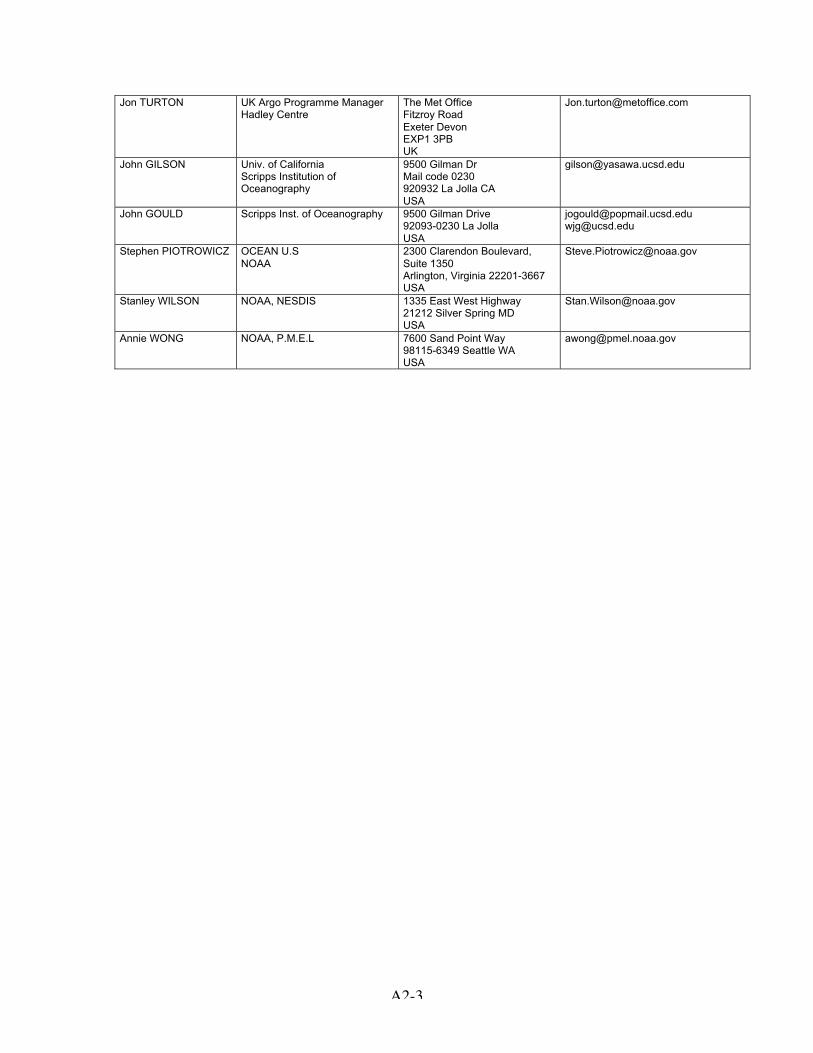
Appendix 2 Attendance list
Dean ROEMMICHIAST Chair
Scripps Inst. of Oceanography 9500 Gilman DriveLa Jolla 92093-0230USA
Yves DESAUBIESIAST Exec
IfFREMERLab. de Physique des Océans
BP 7029280 PlouzanéFrance
Howard FREELANDIAST Exec
Inst. Of Ocean SciencesDept of Fisheries & Oceans
P.O Box 6000V8L 4B2 Sidney BCCanada
Kuh KIMIAST
Seoul National UniversitySchool of Earth &Environmental Sciences
56-1 Sillim-dong, Kwanak-kuSeoul 151742Korea
Brian KINGIAST
Southampton OceanographyCentreJames Rennell Division
Empress DockS014 3ZH SouthamptonUnited Kingdom
Breck OWENSIAST
Woods Hole OceanographicInstitution
266 Woods Hole RoadWoods Hole, MA02543USA
KopillilRADHAKRISHNANIAST EXEC
Indian National Centre forOcean Information Services(INCOIS)
DOD, Plot #3, Nandagiri HillsJubilee Hills500 033 HyderabadIndia
[email protected] ;[email protected]
Uwe SENDIAST
IfM/GEOMAR Kiel Düsternbrooker Weg 2024105 KielGermany
Kensuke TAKEUCHIIAST Exec
JAMSTEC 2-15 Natsushima-choYokosuka 237-0061Japan
Susan WIJFFELSIAST Exec
CSIRO Marine Research GPO 1538Castray Esplanade7000 HobartAustralia
Xu XIANPINGIAST
Second Inst. of OceanographyS.O.A China
PO Box 1207N°9 XiXi HeXia310012 HangzhouChina
Mark IGNASZEWSKIADMT co-chair
FNMOC Observation Division 7 Grace Hopper Avenue93943 MontereyCanada
Sylvie POULIQUENADMT co-chair
IIFREMERCoriolis Project
BP 7029280 PlouzanéFrance
Andreas STERL KNMIDept. of Climate Research
P.O Box 20013730 AE DE BILTNetherlands
Emmanuelle AUTRET LEMAR - UMR 6539Institut Universitaire Européende la Mer
Technopôle Brest Iroise, 29280Plouzané, France
Mathieu BELBEOCH Argo Information Center 8-10 rue Hermès31526 RamonvilleFrance
Thierry CARVAL IIFREMERCoriolis Data Center
BP 7029280 PlouzanéFrance
EtienneCHARPENTIER
JCOMMOPSIOC of UNESCO
8-10 rue Hermès31526 RamonvilleFrance
ChristineCOATANOAN
IFREMERCoriolis Data Center
BP 7029280 PlouzanéFrance
Gaël FORGET IIFREMERLab. de Physique des Océans
BP 7029280 PlouzanéFrance

A2-2
Christian GAC IIFREMERTMSI/TSI/ME
BP 7029280 PlouzanéFrance
Fabienne GAILLARD IFREMERLab. de Physique des Océans
BP 7029280 PlouzanéFrance
Loïc GOURMELEN EPSHOM/CIS/IES 13 Rue du ChatellierB.P.30316, 29603 Brest CedexFrance
Stéphanie GUINEHUT CLS Space Oceanography Div 8-10 rue Hermes31526 Ramonville Saint-AgneFrance
Gilles LARNICOL CLS Space OceanographyDivision
8-10 rue Hermes 31526 Ramonville Saint-AgneFrance
Sylvie LE BRAS IFREMERTMSI/TSI/ME
BP 7029280 PlouzanéFrance
Serge LE RESTE IFREMERTMSI/TSI/ME
BP 7029280 PlouzanéFrance
Gérard LOAEC IFREMERTMSI/TSI/ME
BP 7029280 PlouzanéFrance
Loïc PETIT DE LAVILLEON
IFREMERCoriolis Data Center
BP 7029280 PlouzanéFrance
Gilles REVERDIN LODYCUniv. Paris VI
boite 100,4, place Jussieu, 75252 ParisCedex 05 France
Jérôme VIALARD LODYCUniv. Paris VI
Boite 100,4, place Jussieu, 75252 ParisCedex 05 France
Lars BOEHME Leibniz I.F.MPhysical Oceanography
Düsternbrooker Weg 2024015 KielGermany
Jenny ULLGREN National Univ. of IrelancDept of Earth & OceanSciences
Martin Ryan InstituteN/A GalwayIreland
Koichi ISHIKAWA Japan Meterological AgencyClimate & Marine Dept.
1-3-4 Ote-machiChiyoda-ku100-8122 TokyoJapan
Shinya MINATO JAMSTEC Natsushima-Cyo 2-15237-0061 Yokosuka-ShiJapan
Nobuyuki SHIKAMA JAMSTEC Natsushima 2-15237-0061 YokosukaJapan
Jong Jin PARK Seoul National UniversityOcean Circulation ResearchLab.
San 56-1Sillim-dongn Kwanak-gu151-742 SeoulKorea
Moon-Sik SUK KORDI Argo Program Ansan POB 29425-600 SeoulKorea
Yong-Hoon YOUN METRIArgo Program
460-18 Shindaebang-dongDongjak-gu156-720 SeoulKorea
Tatsuo KOMORI MEXTOcean & Earth Division
2-5-1 Marunouchi, Chiyoda-ku100-8959 TokyoJapan
Rebecca McCREADIE Bristish Oceanographic DataCentre
Bidston HillCH43 7RA Prenton, MerseysideUK
A2-3
Jon TURTON UK Argo Programme ManagerHadley Centre
The Met OfficeFitzroy RoadExeter DevonEXP1 3PBUK
John GILSON Univ. of CaliforniaScripps Institution ofOceanography
9500 Gilman DrMail code 0230920932 La Jolla CAUSA
John GOULD Scripps Inst. of Oceanography 9500 Gilman Drive92093-0230 La JollaUSA
[email protected]@ucsd.edu
Stephen PIOTROWICZ OCEAN U.SNOAA
2300 Clarendon Boulevard,Suite 1350Arlington, Virginia 22201-3667USA
Stanley WILSON NOAA, NESDIS 1335 East West Highway21212 Silver Spring MDUSA
Annie WONG NOAA, P.M.E.L 7600 Sand Point Way98115-6349 Seattle WAUSA

A3-1
Australian ReportSubmitted by Susan Wijffels, CSIRO Marine Research
Status of implementation
Floats deployed and their performance Of the 10 Webb Research Corporation R1-PALACE floats deployed in 1999-2000, one isstill operating, though ironically, this float’s sensors are malfunctioning. The largestnumber of good profiles obtained from these floats is 121. Of the 19 Webb Research Corporation APEX260 floats deployed in 2002/2003, all arestill operating. The rate of voltage drop/profile is less than found in the R1-PALACE,consonant with the expected higher efficiency of the APEX engine. Two of the APEXhave ceased operations due to grounding on the continental shelf. A single MetOceanPROVOR was also deployed during this period and has delivered 46 profiles. Australia has formalized a cooperative agreement with KORDI, Korea to assist with floatdeployments in the Southern Ocean, south of Australia. Over the past year, five KORDIfloats were deployed through this cooperation, and we hope to continue in the future.
Technical problems encountered and solvedWe have not found any serious technical problems during operations over the past year.Methods to avoid the loss of floats through grounding are being looked at. Along withother float operators, we believe that the bladder cowling on the APEX is capable ofpicking up sediment during contact with the bottom, which would increase the float’seffective weight and prevent surfacing. Methods at minimizing the chances of picking upsediments such as sealing or taping over the holes in the cowling are being considered.We are also exploring the ice avoidance algorithms used in other areas of thesubantarctic for upcoming deployments near the latitudes where winter sea ice mayoccur. We continue to replace the lithium battery packs delivered with the APEX floats withlocally sourced lithium packs. These are all diode protected.
Status of contributions to Argo data management:Real time: All profiles are real-time QC’d and published on the GTS and sent to theGDACs. In February 2004, 86% of profiles were delivered to the GTS and GDACswithin 24 hours. Longer delays largely occurred when anomalous profiles are reportedon the weekends. Delayed mode: Regional historical T/S data sets are being assembled and the Wongand Johnson (2003) method tested on float data from the Australian Argo array.Manpower for this activity is still limited, though proposals to increase it are beingconsidered. Australia still hopes to eventually establish a Regional Delayed Mode QCservice.
Contribution to Regional Coordination:In December 2002, Helen Phillips established a website for the coordination of Argofloats in the Indian Ocean and has been actively coordinating deployments there. Indiawill soon take over this role.

A3-2
National fundingFloat acquisition: Australian Argo is a joint program between the CSIRO MarineResearch (CMR) and the Australian Bureau of Meteorology (BoM). The CooperativeResearch Center for Antarctic Ecosystems and Climate (ACECRC) will acquire floats fordeployment in the subantarctic zone south of Australia. CMR has committed to acquire10 floats per year, the ACECRC will acquire 14-15 floatsper year and the BoM may acquire 6-7 floats per year in future years. Hence theAustralian float acquisition will be sustained at about 30 floats/year over the next fewyears. Human resources: Australian Argo requires approximately 50% of a fulltime engineer forfloat checkout and preparation; 20% of a fulltime operations officer for float shippingcoordination and deployment training; 30% of a fulltime data expert for real time datamonitoring and conversion to netcdf formats etc. Scientific analysis, coordination andoversight are supported by 1.3 fulltime equivalents.
Deployment plansAustralia will continue to maintain a float array between 100°E and its west coast. Plansto greatly expand coverage of the subantarctic zone southwest of Australia have beendelayed by up to one year due to the float sensor recalls by Seabird Electronics. In theupcoming Austral summer, we plan to deploy about 35 floats between Australia andAntarctica. Future deployments will see coverage of the Tasman Sea.
National research and operational uses of Argo data:· Argo data are routinely used in the operational upper ocean analyses of NevilleSmith at the Australian Bureau of Meteorology(http://www.bom.gov.au/bmrc/ocean/results/climocan.htm). These analyses are alsoused to initialize an experimental seasonal rain forecasting system.· A collaborative analysis of Argo data off Sumatra and Java began in 2003 with avisit by Bagus Hendrajana from the Indonesian Agency for Fisheries and MarineResearch. This work was presented at the Argo Science Workshop in November.· Large scale interannual salinity anomalies captured by Argo in the eastern SouthIndian Ocean are being investigated by Helen Phillips, a postdoctoral investigator atCSIRO Marine Research. This work was presented at the Argo Science Workshop inNovember. [email protected]· CSIRO Marine Research, in collaboration with the Bureau of MeteorologyResearch Center, is developing an ocean model/data assimilation system for oceanforecasting and hindcasting. Argo data will be the largest in situ data source for thissystem. Work on subsurface profile assimilation is underway. PI:[email protected]

A3-3
Canadian National report(Submitted by Howard Freeland)
1. Status of Float DeploymentsFloats deployed since March 2003:Summary-1: 10 APEX Floats deployed with data return of 99.99%Summary-2: 17 Metocean PROVOR floats deployed with data return of about 82%.
a) Pacific Deployments:10 APEX floats were deployed in the Gulf of Alaska, all using the Apf8a controller board,and 9 have returned 100% of the expected number of profiles. The single floatsupplying less than 100% is missing message #1 from one profile. All data are of highquality.
b) Atlantic Deployments:17 PROVOR floats have been deployed in the northwest North Atlantic in 2003. All weremanufactured by the Metocean Corporation of Dartmouth, Nova Scotia. Of the initialdeployment of six floats in July, four suffered pressure parameter problems which arelikely attributable to the batch of Druck pressure sensors that are known to be defective.Two of these floats have failed completely, one has been on the surface since 5January, 2004 broadcasting continuously, and one (4900423) which gave erratic data forits first ten cycles has appeared to have recovered and has delivered eleven successivegood cycles. The remaining PROVOR floats were returned to Metocean and thedefective SeaBird sensors were replaced. One of the eleven refurbished PROVORfloats failed of unknown causes following its second cycle. As of 18 February, 2004 wehave 13 PROVOR floats providing reliable profiles of high data quality.13 APEX floats were deployed in the northwest North Atlantic in 2002. Two of thesefloats have failed of unknown causes, one after 25 cycles, the other after 64. The overalldata return from these deployments is 94%. 4 APEX floats were deployed in the SlopeWater region of the northwest Atlantic in 2001. Three of these floats have failed after 10,47 and 75 cycles for a current data return of 65%.
2. Status of Contributions to Argo Data Management.
URL: www.meds-sdmm.dfo-mpo.gc.ca follow links to the Argo program.
Operations at MEDS are fairly routine now since the last deployment of floats. Ourautomatic processing runs every 6 hours to acquire data from Canadian floats, buildprofiles, automatic QC and issuing data to the GTS, GDACs and to PIs. Our website isupdated automatically on the same schedule. We have tracking files to alert us whenthings go wrong so that corrective action can be taken.
We regularly find small problems with float data as they arrive which causes delays inissuing data to the GTS. In most cases, this is caused by suspect data in the profile orshort profiles. With special handling, usually we recover the missing portions and thesedata find their way to the GDACs.
We have been busy in the conversion of data to the new data format and replacing allhistorical records at the GDACs with the new form. This is complete.

A3-4
We are finding that we are experiencing slowdowns in unloading data to both GDACs at1200 Eastern Standard Time. We are not sure if this is due to increased traffic on theInternet, or a bottleneck coming out of MEDS.
The standardization of delayed mode QC at the last data management meeting inNovember, 2003, required some changes to our processing. This is underway anddelayed mode data from Canada should be found on the GDACs by the time of the ASTmeeting.
Work will be required to add new data processing software to handle the floats withOptode sensors. We will be discussing what to do with these data in the global datasystem at the upcoming data management meeting.
3. National Funding for Argo Operations (not including use of Argo)The Canadian Argo program is relatively small but is spread across three institutions.The central management of the Canadian strategy for Argo is based at the Institute ofOcean Sciences (IOS) in Sidney, British Columbia. Deployments for the Atlantic arebased out of the Bedford Institute of Oceanography (BIO), Halifax, Nova Scotia, anddata management centred at the Marine Environmental Data Service (MEDS) in Ottawa.
Human resources dedicated to Argo operations add to 5. PYs
Purchase of floats is conducted on an ad hoc basis but is typically C$600k/year =US$390k/year.
Operations are funded through a single grant issued specifically to support Argooperations and amounting to about C$360k (US$235/year). This supports shipping,data management, travel, computing requirements and three technical support salaries.
4. Deployment PlansOur deployment plans are rather ad hoc as we are rarely able to predict from one year tothe next how many floats we will have to deploy or indeed if we will have any floats todeploy. As of writing we have 51 floats on order. Two of the N. Atlantic floats and two ofthe Pacific floats will carry Aanderaa Optode sensors. We also have several floatsremaining on inventory from 2003 and 2 of these will be deployed with the assistance ofSHOA/Chile in September 2004.
The North Atlantic deployments present a particular challenge because of the strongboundary currents along the western boundaries of the sub polar and sub tropical gyres.We are attempting to maintain the Argo array in the north-western North Atlantic north of35°N and west of 40°W. Many of the floats deployed in this region eventually getcaptured by the western boundary currents and the North Atlantic Current and getcarried to the south and east. This would be okay if there was a steady supply of floatsto the regions upstream of our region to fill the gaps. There are presently few activefloats in the Irminger Sea to replace the Labrador Sea floats that are being swept southto Flemish Cap and the North Atlantic Current.
Because of the late release of funds to purchase floats in the first quarter of 2004, wehave not yet developed a deployment plan for this large inventory of floats. We will useour presently scheduled oceanographic cruises in the North Pacific and North Atlantic tofill gaps in the Argo float array in the Gulf of Alaska, along the Canadian Atlantic

A3-5
continental margin and in the Labrador Sea. This can be done in both the spring and thefall. We have not requested specific Canadian ship time to deploy floats over a largerregion of either the North Pacific or Atlantic nor have we yet explored deploymentopportunities from Canadian naval vessels or foreign research vessels. It seems likelythat a large part of this inventory will remain to be deployed in 2005 at which time weexpect that many of the Gulf of Alaska Floats deployed in 2001 will need replacement.
5. National Research and Operational Uses of Argo DataDuring August 2002 a meeting was held in Halifax, Nova Scotia, to discuss thedevelopment of ocean data assimilation and similar strategies within Canada and theuse of the new real-time ocean data sets. The meeting was hosted by CMEP (CanadianCentre for Marine Environmental Prediction) which is a new agency funded partially byacademic funding agencies and partially by the federal government. CMEP is based atDalhousie University in Halifax. At that meeting a decision was announced by theDirector of the Meteorological Service of Canada to develop a global coupledatmosphere/ocean data assimilation model. The following projects are ones that I amaware of within Canada that use Argo data.
1) Atlantic Ocean data assimilation - A project funded by the CFCAS (CanadianFoundation for Climate and Atmospheric Science) to develop data assimilation andhindcast tools for the N. Atlantic. The Principal Investigators are Keith Thompson(Dalhousie University) and Dan Wright (Bedford Institute).
2) Pacific Ocean data assimilation - A project funded by the CFCAS (CanadianFoundation for Climate and Atmospheric Science) to develop data assimilation andhindcast tools for the Gulf of Alaska. The Principal Investigators are Mike Stacey(Royal Military College), Mike Foreman and others at IOS.
3) Pacific Ocean data assimilation - A project funded by the Department of Fisheriesand Oceans “Strategic Science Fund” to parallel and assist project 2).
4) Mixed layer mapping in the Gulf of Alaska: This project is funded at the University ofAlberta (PI = Paul Myers) to study the evolution of mixed layer depths in the Gulf ofAlaska focussing on the data from Argo, funds derive from the Dept of Fisheries andOceans “Science Subvention Fund”.
5) Antarctic Intermediate Water formation: This project is funded through the CFCAS,the PIs are Richard Karsten (Acadia University, Nova Scotia) and Howard Freeland(IOS) and will study the floats recently deployed in the formation area for AntarcticIntermediate water. A Post-Doctoral Fellow has been hired and will be presenting apaper at the spring AGU meeting in Montréal.
6) Gulf of Alaska cold pool: This project is funded through the DFO ScienceSubvention Fund. The PI is William Hsieh at the University of British Columbia,Vancouver. The object is to study with a combination of modelling and analysis ofArgo data an unusual invasion of sub-arctic water that occurred during 2002.
7) Pacific – State of the Ocean: Howard Freeland as part of his job at IOS monitors thestate of the environment in the Gulf of Alaska. Conditions have been extremelyunusual during the last 2 years and upper-ocean stratification has never been ashigh as has recently been seen. This threatens to reduce the supply of nutrients tothe productive zone with impacts on the ecosystem seen in 2003 and further likelyduring 2004.
8) Atlantic – State of the Ocean: Profile data from the Argo floats deployed over theContinental Slope in Atlantic Canada are being examined as part of the regionsannual assessment of the state of the ocean environment. This document is

A3-6
produced for the Fisheries Oceanography Committee of the Canadian RegionalAssessment process. These documents are also presented at the annual meetingsof the North Atlantic Fisheries Organization (NAFO) and the International Council forthe Exploration of the Seas (ICES). Movement of cold Slope Water equatorwardalong the Continental Slope is an infrequent occurrence that has significant impacton the shelf fisheries from the Eastern Scotian shelf to the mid Atlantic Bight.

A3-7
Chinese National report(Submitted by Jianping Xu)
1. Status of implementation1.1) Floats deployed and their performancesUnder the support from MOST (Ministry Of Science and Technology) and SOA (StateOceanic Administration), China Argo project in the 2003 F-Y deployed 3 APEX floats inthe sea area of northwest Pacific Ocean. Since the first float was launched in the easternIndian Ocean in March 2003, China has totally deployed 24 floats, of which 2 in theIndian Ocean and 22 in the Pacific Ocean.
Those floats were differently provided, 13 PROVOR floats by MetOcean Company inCanada, and 11 APEX floats by Webb Research Corporation. At present, there are 11floats operation in waters, and 2 floats have been taken to Philippines coast bays.
The 24 floats were all deployed from R/V (Xue Long and XiangYang Hong 14). At thesame time, ship-based CTD and Laboratory Salinometer (Guild Line Auto Sal 8400B)are used to make synchronous observations of T/S. Water samples are taken in order toget the standard salinity value near the Argo floats deployed, for the purpose ofunderstanding the CTD’s performance and correcting the in-situ data provided by theArgo floats. In 2003, National Ocean Technology Center (NOTC) deployed 2experimental COPEX floats in the northwest Pacific.
1.2) Technical problems encountered and solvedIn the past year, there mainly were two technical problems encountered: One problemwas probably caused by floats’ communication obstacle. That is, some floats had nosignal when tested in laboratory by uplink receiver; some float, even if passed the Labtest, could just provide 1-2 profiles and then fail. The problems mostly come from thePROVOR floats. The second problem was caused by the float’s pressure sensor. Afterfloat normally worked several profiles, the following profiles became shallower andshallower with pressure abnormal, until float remained on the surface. This problemmainly occurred on a batch of the APEX floats. But recently this situation also happenedto the PROVOR floats.
According to the float manufacturer’s analysis, it was the sensor producer provided theunqualified pressure sensors that caused the trouble. Now the reason has been foundand the problem has been resolved. And from now on this problem will never happen.We hope the float quality be surely further improved. According to the deployed-floatstatistics of 2003, there exist only 50% floats that could routinely run over a whole year.
The 2 experimental COPEX floats (developed by NOTC) separately configured the FSI-CTD sensor and Sea-Bird CTD sensor. Though the 2 floats got some profiles, there is agreat difference between the designed observing depth and the actual observed depth.And it remains to be improved.
1.3) Status of Contributions to the Argo data managementThe China Argo Data Center (Chinese Language Web Server) began to work in 2002,which are used to distribute Argo data and its products, and related information. Its datacomes from the Global Argo Data Centers via the international website. Using the ArgoReal-time and Delayed Mode Quality Control Models recommended by InternationalArgo Data Management Group, China Argo Data Center produces Argo data disk and

A3-8
provides for the home users.
The China Argo Real-time Data Center, under the China Argo Data Center, isresponsible for the Argo floats deploying, real-time data receiving /processing anddistributing. Assisted by the School of Oceanography (University of Washington, USA),an Auto-online Argo Real-time data/products exhibiting system was set up in the ChinaArgo Real-time Data Center. Also according to the Argo Real-time and Delayed ModeQuality Control Models recommended by International Argo Data Management Group,Argo data are received and corrected and distributed by Web-net, and Argo data disksare periodically produced and provided for the home users.
In July 2003, National Marine Environment Forecasting Center (under SOA) received theGlobal Argo floats profiles on the GTS, which were transmitted by China GTS ’sReceiving Station-China Meteorological Administration.
2. National fundingPresently, the fund for the China Argo floats deployment is mostly coming from theMOST, and SOA gives the support of R/V for the floats deploying. The Argo dataapplication research is mainly supported by the NNSF (National Natural ScienceFoundation of China) and the SOA. The Chinese scientists are now looking for anational specific fund for the implement of China Argo project.
3. Deployment PlansIn the 2004 F-Y, China will deploy 16-20 floats in the areas of North Pacific (10), WestEquatorial Pacific (4-6) and Eastern Indian Ocean (2-4). In addition, another 2experimental COPEX floats will be deployed in the North Pacific.
4. Research Applications of the Argo dataIn the past year, the Argo project become gradually known by public (via the media,Argo Webs and scientific conferences). The data has been more widely applied byuniversities and institutions in China. The Chinese Academy of Meteorological Sciences,Second Institute of Oceanography, Ocean University of China, First Institute ofOceanography, National Marine Environment Forecasting Center etc., all has researchgroup for the application research of Argo data in the oceanic and atmospheric fields.And a sum of successful research results have presented, such as “ Application of a4DVAR data assimilation system to the Argo data”, “ Research on the circulation andwater mass in the West Pacific with the Argo data”, and “ The decreasing of sea surfacesalinity by the typhoon in the northwestern Pacific warm pool area”. The China NationalClimate Center has being tried to apply the Argo data to the operational forecasting of “Global Sea-Atmosphere Coupled Model (CGCM)”. As the global Argo data increasing, itwill definitely be more and more used in the fields of oceanography and atmosphere.
5. Issues for the AST-65.1) Up to now, there are over1000 floats running in the oceans. It is suggested that AICproduces a disk for the delayed-mode controlled Argo data set, and distributes to thecountries and regions, especially to those who are presently has no GTS receivingstations and Internets, which would expand the influence of the Argo Project and the useof the Argo data worldwide, and attract more countries and regions to join the ArgoTeam or get their support.
5.2) As the Argo floats increasing in the seas, there is an increasing probability of the

A3-9
floats being encountered by coast people or fisherman. For this issue, someInternational Organizations as WMO etc should make effort to recover those floats. Thathas at least two advantages. Firstly, those floats could be reused and thus reduce thecost of floats and their deployment. Secondly, those floats can provide manufacturersmore information about the float’s performances and trouble reasons, and enable themto improve float’s working period. At present, about 50% floats can’t effectively work for ayear, which disappoints the float users.
5.3) Presently, there is no GTS interface at the China Argo Real-time Data Center, andwe could not insert the Data onto the GTS. Instead, we have authorized CLS to issue toGTS. But much data has not been sent to GTS; and some profiles are not completelysent to GTS. So we appeal the DADCs could improve this situation, ensure that theChina Argo data be shared by all the Argo member countries.

A3-10
French (Coriolis project) and European (Gyroscope) reports(Submitted by Yves Desaubies and Sylvie Pouliquen)
CORIOLIS: http://www.coriolis.eu.orgGyroscope: http://www.ifremer.fr/lpo/gyroscope
Organisation at French levelThe French Argo Project is handled through a multi agency project named CORIOLISand supported by 7 agencies: CNES, CNRS, IFREMER, IRD, INSU, IPEV, Meteo-France and SHOM. It started in 1999 with the Pomme experiment for which the firstprototypes of Provor floats equipped with FSI sensors were deployed. Float deploymentis handled by IFREMER, SHOM and INSU. Data processing is operated by IFREMER.
Status of Implementation
Cruise name Period Number ofFloats
Deployed/active
Ocean Vessel
Flostral January 2003 15/12 Indian Marion Dufresne 2PIRATA February
20035 /2 Atlantic Guinea Gulf.
Support to UK-ArgoSuroît
ETO May 2003 19/17 South Atlantic + Indian BHO Beautemps-BeaupréMFSTEP October 2003 2/2 Mediterranean sea
Flostral 2a January 2004 10/10 Indian Marion Dufresne 2Total 51/43 5 funded by UK-Argo
During 2003, some deployments on opportunity cruises were cancelled at the end of theyear because of the lack of available floats due to an unplanned change in the FSIsensor definition.
During 2003 Provor float equipped with FSI sensors have been deployed in tropicalAtlantic and have experienced salinity jumps probably due to bio-fouling on theconductivity cell. Some of these jumps will be corrected during the delayed mode QCprocess, others jumps and unstable drifts are unrecoverable. We have decided to stopdeploying FSI sensors in these areas.
In October 2003, the first Provor floats, equipped with SBE sensors and developed byMartec /France have been successfully deployed during the test phase of the EU projectMFStep. They have been recovered after one month at sea and have provided resultscompatible with the Apex that were deployed in the same area. These floats will beredeployed next summer during the operational phase of MFSTEP.
Gyroscope ProjectThe year 2003 was the final one for the GyroScope project (2001-2003), which waspartially funded by the Commission of the European Community under its 5th FrameworkProgramme. As a cost-shared action, over half of the funding came from participatinginstitutions. Thus, GyroScope must not be seen as an exclusively European Communitycontribution to ARGO, but also of the agencies listed.

A3-11
GyroScope was coordinated by IFREMER, with the following partners :France : Centre National de la Recherche Scientifique (CNRS), Service
Hydrographique et Océanographique de la Marine (SHOM), and CollecteLocalisation Satellites (CLS)
Germany : Institut für Meereskunde (IFM/Kiel) presently Leibnitz InstituteUnited Kingdom : Met Office and Southampton Oceanography CentreSpain : Instituto Español de Oceanografia, Institut de Ciències del Mar, and
Universidad de Las Palmas de Gran Canaria (ULPGC).
The project has been very effective in increasing visibility and awareness of ARGOwithin Europe; it has enabled participation of several scientists and agencies in the fullrange of activities from instrument procurement, operations at sea for deployment, datavalidation, data analysis and scientific investigation of the North Atlantic. The CoriolisData Centre, which was one of the Ifremer partners, played a central role in the datamanagement.
A total of 84 floats (APEX and Provor) were deployed, during 10 cruises. At the end ofthe project, 61 floats are still active, with excellent data return. The experiment was thefirst opportunity for large scale deployment of the newly designed Provor float and fordemonstration of its operational capability.
A significant role has been played by the project (LPO end IFM) in pursuing delayedmode quality control procedures. A workshop was organised in October in Brest toreview and assess various methods, leading to the demonstration of improvedperformance of the Boehme and Send method in regions of rough bathymetry, boundarycurrents, complex water masses and high inter-annual variability, such as the sub-polargyre.
Various scientific results of the project were reported during the ARGO ScienceWorkshop in Tokyo, as listed below.
Several of the GyroScope participants have been very active in promoting ARGO indiverse programmes and agencies : GOOS, GODAE, CLIVAR, the EuropeanCommunity, the GMES (Global Monitoring for Environment and Security) initiative of theESA, and EC, as well as within their own countries.
Complete information on the project can be found on : http://www.ifremer.fr/lpo/gyroscope
Data Management activitiesCORIOLIS acts as a DAC and a GDAC for Argo program and is setting up a RDAC forNorth Atlantic ocean.
• DAC : data assembly center Coriolis process 176 actives floats (282deployed) for 7 countries and 11 scientific programs. Coriolis process threestypes of floats (Provor, Metocean, Apex) ie 15 different versions . Data arequalified in real-time and good data are distributed with 24h both on GTS andGdac. Based on expertise gained within the Gyroscope project we are settingup the delayed mode processing chain developed by Ifm/Kiel.
• GDAC : global data center. Together with the US-GODAE server inMonterey, Coriolis is a global data center for Argo and is fed daily by 6 DACs

A3-12
:AOML (USA), MEDS (Canada), JMA (Japan), Coriolis (France), BODC (UK),CSIRO (Australia) GDACs handle data from more than 1400 floats Argo(more than 50 000 cycles). The two GDAC are synchronized daily sinceSeptember 2003. The 11th February 2004, all data at GDACs have beenregenerated in 2.1 version format which allows to handle properly the delayedmode data processed by the DACs.
Global GDAC coverage, December 20031400 floats, 50 000 cycles
Coriolis Dac coverage for 2003, 176 active floats, 7 countries,
11 scientific programs.
Number of new cycles available each month at Coriolis GDAC since 1997
CORIOLIS team is deeply involved in data format and Argo network definition and co-chair the Argo data management committee.
National FundingIFREMER and SHOM are planning to purchase floats in the coming years. Up to nowIFREMER committed to buy about 70 floats in 2004, and probably between 30 and 50 in2005; SHOM will buy 15 floats per year for three years.
France will continue to contribute to Argo through the CORIOLIS data centre acting as aNational centre for France and other European countries, as a GDAC for the Argoprogram, and will set up a Regional Dac for the North Atlantic. CORIOLIS will alsocontinue to help some countries in their float data processing while they set up their ownfacility.

A3-13
In the course of the MERSEA project (see below) 40 additional floats will be purchasedand deployed in 2004 (or 2005), with funding from the European Community.
Deployment plans
Cruise Name Period Number of Float Ocean Vessel RemarkGood Hope February 2004 16 Antarctic S.A. Agulhas Approved
CIRENE October 2004 20 Indian Marion Dufresne2
Approved
CONGAS May thanNovember
2004
11 Atlantic Bay of Biscay BSHM Opportunity
LAPLACE April 2004 5 North AtlanticGuinea gulf
BH2 Laplace Opportunity
OVIDE June 2004 10 North Atlantic Thalassa Opportunity
BOUDEUSE June 2004 5 Inter-Tropical Atlantic La Boudeuse OpportunityMD2 August 2004 To be defined North and South Atlantic Marion Dufresne
2Opportunity
AMT September2004
5 North and South Atlantic James Clark Opportunity
BBP Setpember2004
To be defined Mediterranean sea Beautemps-Beaupré
Opportunity
A lot of uncertainty still needs to be addressed before a fixed plan is made for 2004. Thiswill be finalized soon according to the float availability, gaps in oceans along the vesselstransects.Up to now the planned map is the following:

A3-14
National research and operational use of Argo data
Operational use
Product development : (PI : F.Gaillard)In support of the Coriolis data centre, data syntheses by objective mapping have beendeveloped and implemented operationally. Maps –and the associated data files –areavailable on a weekly basis. The method uses temperature and salinity profiles fromprofiling floats, XBTs, XCTDs or CTDs, drifting and moored buoys.
In order to both qualify the data and provide temperature and salinity analysed fields, anobjective analysis method has been developed for the Atlantic: 60°S - 70°N, 98°W -20°E.
Using the temperature and salinity profiles from the CORIOLIS data base, real timeanalyses are performed by the CORIOLIS data centre once a week. The analysed fieldsare constructed on a grid with one third of degree resolution in latitude and longitude at59 levels from 5 down to 2000 meters depth.
MERCATORCoriolis and the French ARGO contribution are closely associated with the MERCATORoperational system.The MERCATOR mission was defined in 1996 by six partner organizations -CNES,CNRS/INSU, Ifremer, IRD, Météo France, and SHOM The project is pursuing threegoals:
1) Develop an operational oceanography system that is:• ready for operational use,• based on a high-resolution primitive-equation model,• capable of assimilating satellite and in-situ ocean observation data.
2) Develop downstream oceanography applications
Mercator must:• support public service, civil protection and military applications, as well as
commercial oceanography applications, by providing a real-time description of sea-state conditions and predicting flows of water masses;
• provide a research tool that will help the scientific community to interpret the resultsof experimental research programs and measurement campaigns;
• contribute to the development of seasonal climate foecasting by providing oceaninitial conditions for ocean-atmophere coupled models.
3) Contribute to the international GODAE project, alongside the Jason satellite altimetryand CORIOLIS programme of in-situ measurement, Mercator is France's contribution tothe Global Ocean Data Assimilation Experiment (GODAE).
MERCATOR presently produces global, low-resolution (2°) analyses and forecasts, andhigh resolution (1/15°) for the North Atlantic and Mediterranean, assimilating altimeter,SST, and in situ (including ARGO) data.

A3-15
The Mersea project
MERSEA1 is a new 4 –year project (2004 –2008), with significant funding from the CEC2
under its 6th Framework Programme of R&D. The key objective of MERSEA to develop aEuropean ocean monitoring and forecasting system in support of the Ocean and MarineApplications of GMES
3. The project, co-ordinated by IFREMER, includes 40 participatingAgencies, Research Centres or Companies in 13 EC countries. The major globaloperational systems (FOAM in the UK, Mercator in France, MFS in Italy, and TOPAZ inNorway) are key participants. They all assimilate routinely ARGO data. MERSEA willcoordinate the EC contribution to GODAE. These activities will give high visibility to theARGO programme, as well as demonstrate its utility for operational oceanography.
Research programmes
Calls for proposals have been issued within France to encourage wide participation ofFrench scientists in scientific projects that can benefit from ARGO. Several of thoseprojects are in collaboration with international programmes.
OVIDE : (PI : H.Mercier). An observatory of inter-annual variability of the thermohalinecirculation in the North Atlantic. [ http://www.ifremer.fr/lpo/ovide. ].The Ovide project aims at repeating a trans-oceanic hydrographic section fromGreenland to Portugal every other year. The project also includes the ARGO data set tointerpolate on a seasonal scale the ocean circulation. The goal is to contribute to themonitoring of the inter-annual variability of the water masses as well as the variability ofthe mass, heat, and tracer transports in the northern North Atlantic Ocean. This is acontribution to CLIVAR. The OVIDE line will be reoccupied in 2004, and 2006, with floatdeployments and moorings to monitor the variability of the East Greenland Current .
EGEE : (PI : B.Bourlès). Oceanic circulation and its variability in the Gulf of GuineaAtlantic. Programme coordinated with the African Monsoon project AMMA.The main objectives of the project are to study the oceanic circulation and its variabilityin the upper layers of the eastern Tropical Atlantic, mainly in the Gulf of Guinea (GG)and the linkages with the climate of the neighbouring regions. The intensity of theWestern African Monsoon intensity depends upon the meridional energy gradientsbetween the GG and the continental regions (West Africa). One of the prior scientificquestions lies in the comprehension of the oceanic processes that control the energyexchanges at the ocean-atmosphere interface in the GG, and particularly the seasurface temperature (SST) and its variability, from seasonal to interannual time-scales.
FLOSTRAL : (PI : R.Morrow). The main objective of the FLOSTRAL project is to furtherunderstand the mechanisms that govern the circulation of SAMW / STMW, and how theirwater mass characteristics are modified during that circulation. With this aim, anessential element of the FLOSTRAL project is to establish a network of PROVORprofiling drifters in the southern Indian Ocean in 2003-2004. 15 floats have already beenlaunched. Another 15 will be launched in 2004.
1 Marine Environment and Security for the European Area2 Commission of the European Community3 Global Monitoring for Environment and Security

A3-16
GOODHOPE : (PI : S.Speich) aims to establish a programme of regular and appropriateobservations (XBT, CTD, floats etc.) along the SR2 between South Africa andAntarctica. The objectives are to gain a better understanding of the Indian-Atlanticinterocean exchanges (including their effect on the climate of the African continent); tomonitor the variability of the Southern Ocean frontal systems; and to study the local air-sea heat exchanges and their role in the global heat budget.
CIRENE : (PI : J. Vialard). The main scientific objective of the CIRENE proposal is toinvestigate the ocean-atmosphere variability in the Indian Ocean sector (58°E-85°E,9°S-3°N) from intraseasonal to interannual time-scales. A particular emphasis is put onunderstanding the physical processes at the origin of the intraseasonal variability. Amore general question concerns the scale interaction between the interannual variationof the thermal structure of the Indian Ocean and different characteristics of the Intra-seasonal Oscillations (amplitude, propagation, associated dynamical perturbation, linkwith the Pacific Ocean,…).
Product development : (PI : F.Gaillard)This is an extension and scientific use of the objective mappings presently available onthe Coriolis site. Initially, the study focuses on the North Atlantic; it will then be extendedto the global ocean.Reanalyses of the Coriolis in situ data base will be performed from 2001 to 2003 (andonwards); with extraction of the dominant modes of variability and consideration of watermass properties, mixed layer characteristics and climatic indicators. Priority is given totemperature and salinity. These data-based syntheses will be used to validate theoutputs of operational models that assimilate all available data.
A 4DVAR analysis of ARGO profiles in the North Atlantic (Thesis in progress by G.Forget, supervised by B.Ferron)
A 4DVAR analysis of the recently available ARGO profiles for the period June 2002-May2003. The estimation problem consists of determining TS initial conditions of a NorthAtlantic configuration of the MIT model (1 degree resolution). Data assimilation clearlyimproves the model water mass properties and partly modifies the associated oceaniccirculation. TS anomalies compared to climatological values are evidenced. Some focusis additionally put on the estimated seasonality. Consistency checks, comparison withtwin experiments and elements of model validation are provided to investigate the qualityof our estimates. Finally, the work illustrates the information that ARGO profiles wouldprovide to more complete assimilation systems.
Issues to be considered by AST
Data management Issues raised by Data Management committee:• Delay Mode QC:
� The question of QC on sliding window was not solved at ADMTmeeting. If we do a sliding window QC what is the size of thewindow?
� Feedback to real time of correction made in delayed mode?
• How to organize feedback from users?• How to improve trajectories data?• Ask AST to stamp Scientific products that should be advertised through AIC

A3-17
9. Presentations at the ARGO Science Workshop in Tokyo for France andGyroscope project
Autret E, F Gaillard : Analysis of Temperature and Salinity in the N Atlantic. Poster.
Carval T., L. Petit de la Villéon, C. Coatanoan : CORIOLIS data centre: In situ data for operational oceanography. Int.ARGO Science Workshop. Tokyo. Nov. 2003. Poster.
Desaubies Y., L. Boehme, and U. Send : Experience of delayed mode quality control for the Atlantic. Int. ARGO ScienceWorkshop. Tokyo. Nov. 2003. Oral.
Desaubies and Gyroscope partners, The GyroScope project : objectives, overview, and preliminary results. Int. ARGOScience Workshop. Tokyo. Nov. 2003. Poster.
Grit C. and Herlé Mercier : Determination of North Atlantic circulation by inversion of profiling float data. Int. ARGOScience Workshop. Tokyo. Nov. 2003. Poster.
Guinehut S., Pierre-Yves Le Traon and Gilles Larnicol, Comparing and combining Argo data with altimeter data. Int.ARGO Science Workshop. Tokyo. Nov. 2003. Poster.
King B. The detection of subsurface theta-S changes. Int. ARGO Science Workshop. Tokyo. Nov. 2003. Oral.
King B. and Louise M Duncan. Comparison of float profiles with an assimilating model (FOAM) in the North Atlantic. Int.ARGO Science Workshop. Tokyo. Nov. 2003. Poster.
Le Grand P. and Jean.-Pierre Mazé : Near real time velocity estimates using float profiles. Int. ARGO Science Workshop.Tokyo. Nov. 2003. Poster.
Le Traon P-Y. : Argo and GODAE. Int. ARGO Science Workshop. Tokyo. Nov. 2003. Oral.Wood R., H.T. Banks, M. Vellinga, S. Stark, M. Palmer, Potential of Argo data for detection and attribution of oceanicclimate change. Int. ARGO Science Workshop. Tokyo. Nov. 2003. Oral.
Mercier H. and T. Hascoet : Characteristics and variability of Subpolar mode water in the North Atlantic, as observed fromArgo floats. Int. ARGO Science Workshop. Tokyo. Nov. 2003. Poster.
Pouliquen S., Thierry Carval, Yves Desaubies, Loic Petit de la Villéon, Gérard Loaec. Operational oceanography inFrance: the CORIOLIS project. Int. ARGO Science Workshop. Tokyo. Nov. 2003. Poster.
Ruiz S., D. Gomis, and Jordi Font. 3D, EOF-based spatial analysis of Gyroscope observations in the North AtlanticOcean. Int. ARGO Science Workshop. Tokyo. Nov. 2003. Poster.
Send U. Argo and other observing systems – issues and challenges. Int. ARGO Science Workshop. Tokyo. Nov. 2003.Oral.
Zenk W., Matthias Lankhorst, Bernard le Cann. Cross-crest pathways of Iceland Scotland Overflow Water in the NorthAtlantic Ocean. Int. ARGO Science Workshop. Tokyo. Nov. 2003. Poster.

A3-18
National German ARGO Report,Submitted by Uwe Send
1) Status of Implementation
Germany now has a national ARGO program funded for the next three years. Thisprogram has three components: subpolar North Atlantic (BSH), tropical Atlantic (IFM-Geomar) and Southern Ocean (AWI). Each of the programs has about 30 floats spreadover the next 2-3 years. In addition there are floats in a number of ocean regions viaresearch projects or from small contributions of institutional funding. Germany also is anongoing partner in the European efforts to contribute to ARGO. Activities and plansunder/for European projects are reported separately, therefore here only the nationaldeployments are outlined.
Subpolar Atlantic/Labrador Sea:In September 2003 there were 7 floats deployed in the New Foundland basin (of whichone failed). These floats drift at 1500 m depth and profile 2000m to surface. In additionthere were 3 Floats with oxygen sensors deployed in the Labrador Sea, of which one isstill operating. The data are processed at Coriolis and are available for ARGO.
North Atlantic:BSH has funding from the German ARGO program for 15 floats to be deployed this year(FY04) along approximately the former WOCE line A2. Looking for deploymentopportunities. The currently operating floats from the previous typical 5 per yeardeployments are shown in figure 1. All floats are processed by Coriolis.
Figure 1:BSH floatsoperating inthe 48Ncorridor as of1 March2004.

A3-19
Tropical Atlantic:Some floats were deployed formerly (10 in March/April 2000, 5 in Nov/Dec 2000) byIfM-Geomar, all at shallow levels (200/400m). Several of these beached on the SouthAmerican coast, a few are still active. The data are are now being processed and madeavailable by Coriolis; some of the older data are not reprocessed yet.August 2004 will see 15 floats of the German ARGO component TROPAT beingdeployed in the western tropical Atlantic (presumably on shallow park levels, butprofiling deep). Some of these (5) will be equipped with RAFOS sensors (someprobably also with oxygen).
Indian Ocean:Initially 15 floats (ARGO equivalent) were funded to be deployed in the south westernIndian Ocean. Due to a failure during the deployment only 4 floats are operational now.
Weddell Sea:Since 1999 a total of 49 floats has been deployed by AWI Bremerhaven, of these 13 areactive at the time of writing. All floats performed well. In the last austral winter (mid2002), 13 floats had been covered by ice, all of which are equipped with the ice sensingalgorithm (ISA, if median 50m-20m temperature is below –1.79 degC, the ascent isabandoned). 11 of these floats survived the ice-cover (one for 25 weeks, i.e. 25 attemptsto surface), while two did not re-appear.The data are available through Coriolis but processed and QC´d separately at AWI.
Figure 2: Results from the Weddell Sea showing the efficiency of the new Ice SensingAlgorithm added from 2002 onwards to AWI floats. The figure plots latitude (colour dots)of a transmitted float profile. X axis is the cycle number, y axis is the float number. The

A3-20
plot shows that in 2002 3 out of 3 floats reappeared after one winter, and in 2003 3+8out of 3+10 floats reappeared. Of these, 9 are currently active, with unknown causes forthe 2 failures after reappearance.
2) Level of funding and deployment plans
Next 3 years:A joint proposal of three research groups at the AWI, BSH and IFM-GEOMAR for aGerman ARGO component is now funded for a three year period beginning Jan. 1.2004. This program has three components, each with approximately 30 floats each in theSouthern Ocean Atlantic Sector (AWI), in the western tropical Atlantic (IFM-Geomar) andin the subpolar North Atlantic (BSH).In addition, there will be several floats deployed within research projects (ARGOequivalent).
The totals are:AWI: 30 floats from German ARGO, 16 float equivalents from AWI fundingIFM-GEOMAR: 30 floats from German ARGO, 7 float equivalents from other projectsBSH: 30 floats from German ARGOIfM–Hamburg: 10 float equivalents from other national projects.
The German share of possible EU funded float projects are explained in the Europeanreport.
Human resources:Within the German ARGO program each of the partners has a three year postdocposition allocated to their subprogram . AWI has devoted 80% of a scientist to ARGO,and is funding a half-time position at a company for float data processing.
ARGO data processing at IfM Hamburg is done within running Arctic projects.
3) Research and operational uses of ARGO
There are no operational uses of ARGO data, but they are used and important invarious research projects, like German CLIVAR, the special research initiative SFB460in Kiel, and smaller individual projects. An important aspect to emphasize is that theintention stated in research proposals to make maximum use of existing ARGO dataseems to have helped review success and leveraged better funding prospects.
A3-21
Ireland National ReportSubmitted by Jenny Ullgren
1. Status of implementationWe deployed two floats in October, one just north and one southwest of Porcupine Bank,off the west coast of Ireland. The parking depth, and the usual profiling depth is 1000 dBbut every third profile is a ‘deep’ one to 2000 dB. The two floats have been reportingsuccessfully to date.
Our floats are handled within the UK Argo programme. The data access is through theBODC. We have only done preliminary checks on the quality to date but we are workingon setting up a system for our delayed mode/manual QC. The data so far has beengenerally good, with some spurious data.
2) Present level of (and future prospects for) national funding for Argo and3) Summary of deployment plansWe are currently negotiating with the Marine Institute, Ireland’s national agency formarine research and development, for more floats in the year(s) to come.
4) Summary of national research and operational uses of Argo dataWe want to use Argo data for a study of the intermediate circulation and water massstructure in the Rockall Trough, more specifically the effect of the winter convection onthe currents entering the area from the south and west. Our two floats were deployed asa part of this project, which also involves two moorings in the southern entrance to theTrough and hydrographic work during cruises in the area.

A3-22
Netherlands national reportSubmitted by Andreas Sterl
1) Status of implementation
The Netherlands, through the Royal Netherlands Meteorological Institute (KNMI), haveonly recently decided to take part in the ARGO programme. While KNMI will cover theorganizational as wel as the scientific part of the project, the deployment of the floats willbe done by the Dutch research vessel Pelagia, operated by the Netherlands Institute forSea Research (NIOZ). First deployments are planned for the summer of this year(2004).
2) Present level of (and future prospects for) national funding for Argo includingsummary of human resources devoted to Argo.
Approved funding for 2004 will allow to purchase three or four floats and to cover thecosts of deployment and telecommunication.At present, funding is decided on a year-to-year basis as part of the regular KNMIbudget. Prolongation will depend on the success of the ARGO programmes as well ason the money available for KNMI. The aim is to make the contribution to the ARGOprogramme a structural part of the budget of either KNMI or another Dutch organization.One person (Andreas Sterl) is working on ARGO. He does so besides is other duties.
3) Summary of deployment plansDepending on exchanges rates, three or four floats will be purchased and deployed inthe Northwest Atlantic during cruises of the Dutch research vessel Pelagia.
4) Summary of national research and operational uses of Argo data
Nothing done yet.
5) Issues that your country wishes to be considered (and resolved) by ASTregarding the international operation of Argo
Nothing.

A3-23
Spanish National report(Submitted by Gregorio Parrilla)
Spain has begun in 2003 her direct contribution to Argo. It started in September this yearwith the deployment of one profiler in the Bay of Biscay and five ones in the areabetween the Canary and Cape Verde islands. A last profiler was deployed in DecemberSW of the Gulf of Cadiz. The floats, all of them APEX; were deployed from Spanishresearch vessels.
A further deployment of six floats, all of them PROVOR; is planned for year 2004. Amain area of interest is the Mediterranean outflow area and the W. Mediterranean Sea,although the mayor part of these floats will be offered to the Argo internationalcommunity to be deployed according to the Argo requirements in some other part of theglobe. There has been already talks with the Technical Coordinator of AIC, MathieuBelbeoch, to initiate conversations with some Latin American countries to establish anagreement for that purpose.
The Spanish Argo contribution has been funded by the Ministerio de Ciencia yTecnología and it is led by the Instituto Español de Oceanografía: other partners areInstituto de Ciencias del Mar, Puertos del Estado, I. Hidrográfico de la Marina, I.Nacional de Meteorología, Universities from Málaga, Castilla-La Mancha, Cádiz y LasPalmas de G. C. and AICO-InterOCEAN.
We continue disseminating, through IEO web page and talks, information about the Argoproject, its data and products and ways to obtain them.
We are planning to submit, through the same channels than the previous one, anotherproposal to acquire more profiles.
The following papers have made use of the Argo data:
Parrilla-Barrera, G., M. Vargas-Yáñez, P. Vélez-Belchi, A. Lavín, C. González–Pola, E.Fraile, A. Hernández-Guerra, E. Tel & D. Vega. 2003. A comparison with the Argoobserving system - Gyroscope 0302 cruise. In “Building the European Capacity inOperational Oceanography”. Proceedings of the Third International Conference onEuroGOOS. Edited by H.. Dahlin, N.C. Flemming, K. Nittis, and S.E. Petersson. ElsevierOceanography Series, 69. 356-360
Vargas-Yáñez, M., Gregorio Parrilla, Alicia Lavín, Pedro Vélez, César González-Pola,Alonso Hernández-Guerra. 2003. Eddy-induced variability in a transatlantic section: ArgoObserving system-Gyroscope 0302 cruise comparison. (Submitted to Journal ofAtmospheric and Oceanic Technology-O)
Vargas-Yáñez, M., Gregorio Parrilla, Alicia Lavín, Pedro Vélez-Belchí, César González-Pola. 2003. Temperature and salinity Increase in the Eastern North Atlantic along the24.5ºN during the last ten years. (Submitted to Geophy. Res. Letters).

A4-1
Appendix 4.
International Commitments for Argo floats- March 2004
Compiled by Stan Wilson [email protected]
This table and the accompanying annotation were reviewed and approved by theInternational Argo Science Team at its meeting in Brest, France 9-11 March 2004.
A “Float Equivalent” is defined as a float—while not funded under the Argo Program—whose data are available consistent with the Argo Data Policy and provides theinformation equivalent to one Argo float.
Australia – FY03 starts Jul 1, 03 – For FY03, 10 floats funded by CommonwealthScientific and Industrial Research Organization - Marine Research (CMR), 1 by Bureauof Meteorology (BoM), and 14 by Antarctic Climate and Ecosystem CooperativeResearch Centre (ACECRC); CMR and ACECRC acquisitions expected to remainsteady, while BoM may increase to 6 per year <[email protected]>
Canada – FY starts Apr 1 – funded by Dept. of Fisheries & Oceans with potential fundingfrom Dept. of National Defense, Environment Canada, and others <[email protected]>
China - FY starts Jan 1 - funded by Ministry of Science & Technology(MOST); implemented by State Oceanic Administration (SOA) in collaboration with otherorganizations; 16 are proposed for FY04 and about 50 for FY05/06/07<[email protected]>
No. of Floats Argo Float Argo Float Argo Float Argo Float Argo Float Argo Float ProposedProp Floatby Country Funded Equiv's Funded Equiv's Funded Equiv's Funded Equiv's Funded Equiv's Funded Equiv's over next Equiv'sDraft 3 Mar 04 FY99 FY99 FY00 FY00 FY01 FY01 FY02 FY02 FY03 FY03 FY04 FY04 3 years over 3 yrsAustralia 10 19 7 25 30 90Canada 10 42 20 25 30 50 90China 10 8 6 16 50Denmark 5Eur. Comm. 10 70 40 10 10France 8 3 50 80 29 44 160Germany 18 22 27 40 32 18 70 4India 10 21 50 69Ireland 2Japan 24 4 76 8 110 3 100 15 95 7 270 7Mauritius 1 2 3Netherlands 3 9New Zealand 2 2 2 2 6Norway 3 6 30Rep. Korea 19 25 30 30 90Russia 1 2 2 2 1 2 10Spain 13 10U.K. 13 50 6 54 10 24 5 38 117 14U.S.A. 55 131 51 174 43 315 39 344 17 412 16 1236 60Totals 75 9 225 75 490 86 639 80 633 79 844 51 2310 95
Totals by Yr. FY99 = 84 FY00 = 300 FY01 = 576 FY02 = 719 FY03 = 712 FY04 = 895 Ave/Yr = 801.6667

A4-2
Denmark – Niels Bohr Institute for Astronomy, Physics and Geophysics deployed 5floats in the Greenland Sea <[email protected]>
European Commission – Gyroscope proposal—submitted by France, Germany, Spain,and U.K.—has funded 80 floats in FY00 and 01, with 40 for Institute für Meerskunde-Kieland 40 for Institut Francais de Recherche pour l’ Exploitation de la Mer (IFREMER)<[email protected]>; Marine Environment and Security for the European Area(MERSEA) proposal will fund 40 floats in FY04 to be implemented by Institut fürLehrerfortbildung, Alfred-Wegener-Institut für Polar- und Meeresforschung, andIFREMER <[email protected]>; and Mediterranean Forecasting System:Toward Environmental Predictions (MFSTEP) will fund 20 float-equivalents in FY04/05,to be implemented as MedArgo by the Istituto Nazionale di Oceanografia e di GeofisicaSperimentale with 5-day profiling to 700m <[email protected]>
France – FY starts Jan 1 – Overall coordination under the national Coriolis Project; mostfunding from Institut Francais de Recherche pour l’ Exploitation de la Mer, with smallercontributions from Centre National de la Recherche Scientifique (20 in FY02) andService Hydrographique de la Marine (3 funded in FY00; 15 per year have beenincluded in the overall number proposed for FY04/05/06); an additional 8 floats werefunded in FY99 as part of POMME <[email protected]>
Germany – FY starts Jan 1 – German Argo funded by the Ministry for Research &Technology (BMBF); implemented by Leibniz Institute of Marine Sciences at KielUniversity (IFM-GEOMAR), Alfred Wegener Institute for Polar and Marine Research(AWI), and Bundesamt für Seeschiffahrt und Hydrographie (BSH). Argo float-equivalents: BSH has funded 18, 5, 7 & 5 floats in FY00, 01, 02 & 03 for North Atlantic;AWI has funded 10, 20 & 10 floats in FY01, 02 & 03 for Southern Ocean; DeutscheForschungs Gemeinschaft (DFG) has funded IFM-GEOMAR for 7 floats in FY01 for Lab.Sea, 10 floats in FY03 for North Atlantic, and 15 floats in FY03 for Indian Ocean<[email protected]>
India – FY starts Apr 1 – funded by Dept. of Ocean Development; implemented byNational Center for Ocean Information Services (lead), National Institute of OceanTechnology, Center for Atmospheric and Ocean Sciences along with National Institute ofOceanography and 6 other academic/R&D/operational institutions<[email protected]>
Ireland – funded by the Ireland Higher Education Authority and implemented by theNational University of Ireland <[email protected]>
Japan – FY starts Apr 1 – funded by Ministry of Education, Culture, Sports, Science &Technology (MEXT) and Ministry of Land, Infrastructure & Transport under theMillennium project (FY00-04); MEXT is expected to fund 80-100 per year for FY05-09;implemented by JAMSTEC. Argo float-equivalents: National Institute for PolarResearch is being funded to deploy 3-5 floats per year in the Southern Ocean; TohokuUniversity was funded for 2 floats in FY03 and is bidding for another 2 in FY04; FisheriesAgency was funded for 5 floats in FY03 and 2-4 in FY04 <[email protected]>
Mauritius – implemented by the Mauritius Meteorological Service in collaboration withU.K. Argo <[email protected]>

A4-3
Netherlands – FY starts Jan 1 – funded and implemented by the Royal NetherlandsMeteorological Institute and Netherlands Institute for Sea Research<[email protected]>
New Zealand – FY02 starts Jul 1, 02 – funded and implemented by National Institute ofWater & Atmospheric Research <[email protected]>
Norway – FY starts Jan 1 – funded and implemented by the Institute of Marine Research<[email protected]>
Republic of Korea – FY starts Jan 1 – funded by Ministry of Science &Technology/Korean Meteorological Administration and Ministry of Marine Affairs &Fisheries; implemented by Meteorological Research Institute (METRI) and Korea OceanResearch & Development Institute (KORDI) under supervision of Korea ArgoSubcommittee of the Korea Oceanographic Committee <[email protected]>
Russia – FY starts Jan 1 – funded by Hydromet; implemented by Far Eastern RegionalHydrometeorological Research Institute (FERHRI) <[email protected]>
Spain – support dependent on funding from Programa Nacional de Investigacion for theInstituto Espanol de Oceanografia, Universidad de Las Palmas de GC, Instituto deCiencias del Mar de Barcelona-CSIC and several other Spanish research institutions<[email protected]>
U.K. - FY starts Apr 1 - U.K. Argo funded by Dept. for Environment, Food &Rural Affairs, Ministry of Defence, and Natural Environment ResearchCouncil; managed and implemented by U.K. Met. Office in collaboration withSouthampton Oceanography Centre (SOC), British Oceanographic Data Centre, andU.K. Hydrographic Office; funding for U.K. Argo to March 06 has been agreed, butlonger-term funding from April 06 has no been assured; additional Argo float-equivalentsdependent on successful bids by SOC for research funding and includes 1 float (FY01)funded by Scott Polar Research Institute <[email protected]>
U.S.A. – FY04 starts Oct 1, 03 – funded by NOAA and Office of Naval Research viaNational Oceanographic Partnership Program; beginning in FY04, NOAA to provide _ ofthe global array (412 floats per year) <[email protected]>. Argo float-equivalents: Naval Oceanographic Office (Navoceano) – 16, 20, 30, 17 & 16 in FY00,01, 02, 03 & 04); NOAA via Consortium for Ocean Research & Climate – 35 in FY00, 20in FY01; the 60 proposed by Navoceano are dependent on availability of funding<[email protected]>; NOAA/OAR/Arctic Program Office – 3 for deployment inBering Sea in FY01 and 9 in Bering Sea and subpolar N Pacific in FY02<[email protected]>