6.0 rail profile - minnesota department of transportation · rail profile 45 6.0 rail profile ......
TRANSCRIPT

Central Minnesota Freight Plan December 2012
Rail Profile 45
6.0 RAIL PROFILE Statewide, Minnesota claims 4,481 miles of active railroad track in the state which ranks 8th in the nation. Two Class I railroads and one switching/terminal railroad operate 391 miles of railroad in the Central Minnesota Region. A map displaying the railroad networks is illustrated in Exhibit 47. Class I railroads in the study area include BNSF Railway (297 miles) and Canadian Pacific Railway (66 miles). Northern Lines Railway (NLR) is the region’s sole switching and terminal railroad operating 28 miles of track in the St. Cloud area. NLR interchanges with BNSF in St. Cloud. In addition to the three rail classes, the Federal government has identified a system of railroads for purpose relating to defense of the United States. These railroads, shown in Exhibit 47, are part of the Strategic Rail Corridor Network (STRACNET).
The STRACNET consist of 38,800 miles of rail lines important to national defense and provides service to 193 defense installations to include Camp Ripley whose mission require rail service.
Exhibit 47: Minnesota Rail System

Central Minnesota Freight Plan December 2012
Rail Profile 46
6.1 Rail Services Provider
6.1.1 Burlington Northern Santa Fe Railway (BNSF)
The BNSF railroad, based in Fort Worth Texas, operates in 28 states covering the western two-thirds of the United States, and two Canadian provinces. BNSF operates 32,000 rail miles serving major markets such as Chicago, St. Louis, Kansas City, Memphis, and New Orleans and several minor interchange locations, including a southeastern connection at Birmingham, Alabama. North American service is provided through connections with Canadian and Mexican railroads. The BNSF operates 1,686 miles (29 percent) of rail and employees 1,598 people in Minnesota. The BNSF in Minnesota emphasizes bulk freight, consisting of Coal, Ore, and Agricultural commodities, along with intermodal traffic on the northern corridor “High Line” between the Pacific Northwest, the Twin Cities and Chicago. BNSF intermodal is split between St. Paul’s Hub Center, with handles domestic traffic, and nearby Union Year in Minneapolis which services the international liner trade. BNSF extends through Wright, Sherburne, Benton, Morrison, Todd, and Wadena Counties, paralleling Minnesota TH 10, a significant highway freight corridor; however, there is no rail line access in the study area.
6.1.2 BNSF Subdivisions Impacting Central Minnesota
BNSF operates six subdivisions impacting the Central Minnesota study region: Staples Subdivision traverses the region from northwest to southeast, and is part of the company’s Chicago-Seattle transcontinental mainline. This line also hosts Amtrak’s Empire Builder service and the Northstar Commuter Line from Minneapolis to Big Lake. BNSF also operates the Hinckley Subdivision on the eastern end of the district. This line extends from Minneapolis to Duluth and is freight only, though it is currently being studied for passenger rail service. BNSF’s Brainerd Subdivision extends from Staples to Duluth and is freight only. BNSF’s Lakes Subdivision clips the northern end of the region. This freight-only line runs between Grand Forks and Duluth. BNSF’s Wayzata Subdivision clips the southern end of the region. This freight-only line runs between Minneapolis and Willmar, MN. BNSF’s freight-only Monticello Subdivision operates a few miles of trackage in the region.
Exhibit 48: Summary of BNSF Subdivisions in Central Minnesota
Subdivision Train/Day At-Grade Crossing
Primary Signal System
FRA Track Class
286 Compliant
Staples 47 237 CTC 4 Yes Hinckley 14 123 TWC 4 Yes Brainerd 9 137 TWC 3 Yes Lakes 7 110 CTC 4 Yes Wayzata 15 98 CTC 3 Yes Monticello 2 51 TWC 2 Yes

Central Minnesota Freight Plan December 2012
Rail Profile 47
Staples Subdivision The Staples Subdivision line runs from University to Dilworth. It connects with the Midway and St. Paul Subdivisions at University as well as CP. At Coon Creek it connects with the Hinckley Subdivision. In St. Cloud, the Northern Lines Railway branches off this Subdivision. In Staples the Brainerd Subdivision connects to this subdivision. In Detroit Lakes it connects to CP and in Dilworth it connects to the KO Subdivision. There are yards at Northtown, St. Cloud, Staples, and Dilworth. Amtrak uses this route for the Empire Builder. CP and UP use the University-Coon Creek segment to get to the Hinckley Subdivision. NLR uses a short segment in St. Cloud to access different industries in town. It sees around 47 trains a day.
Exhibit 49: Staples Subdivision (BNSF)
Hinckley Subdivision This line runs from Coon Creek in Coon Rapids, to the State line near Superior. It connects with the Staples Subdivision at Coon Creek. The St. Croix Valley interchanges with the BNSF in Hinckley. Besides BNSF, CP and UP use this line to access the Twin Ports. This line is the direct connection from the Twin Cities to the Twin Ports. It sees around 14 trains a day.

Central Minnesota Freight Plan December 2012
Rail Profile 48
Exhibit 50: Hinckley Subdivision (BNSF)
Brainerd Subdivision This line runs from Chub Lake to Staples. In Staples, it connects to the Staples Subdivision while at Chub Lake it connects to the Lakes Subdivision. This line is used to access the Twin Ports area from Fargo-Moorhead. There is a yard in Staples and a minor yard and shops in Brainerd. It sees around nine trains a day.
Central Minnesota Freight Plan December 2012
Rail Profile 49
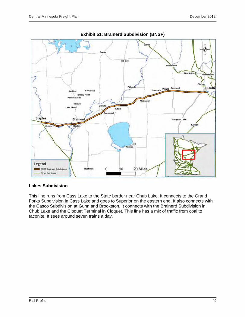
Exhibit 51: Brainerd Subdivision (BNSF)
Lakes Subdivision This line runs from Cass Lake to the State border near Chub Lake. It connects to the Grand Forks Subdivision in Cass Lake and goes to Superior on the eastern end. It also connects with the Casco Subdivision at Gunn and Brookston. It connects with the Brainerd Subdivision in Chub Lake and the Cloquet Terminal in Cloquet. This line has a mix of traffic from coal to taconite. It sees around seven trains a day.

Central Minnesota Freight Plan December 2012
Rail Profile 50
Exhibit 52: Lakes Subdivision (BNSF)
Source: Minnesota Statewide Comprehensive Freight and Passenger Rail Plan
Wayzata Subdivision This line runs from Harrison Street in Minneapolis to Willmar where it connects with the Morris and Marshall Subdivisions. At Harrison Street it connects with the Midway Subdivision, at Lyndale Junction it connects with the Monticello Subdivision and at Cedar Lake Junction it connects with the TCWR. TCWR runs from Harrison Street to Cedar Lake, and UP runs from Harrison Street to Lyndale Junction.

Central Minnesota Freight Plan December 2012
Rail Profile 51
Exhibit 52: Wayzata Subdivision (BNSF)
Monticello Subdivision This branch line runs from Lyndale Junction in Minneapolis to the end of the line in Monticello but is only in regular service to Albertville. The line between Albertville and Monticello is only used for special moves to the nuclear power plant in Monticello. At Lyndale Junction the line connects to the Wayzata Subdivision. From Lyndale Junction to MW Junction UP also uses this line to access its Golden Valley Industrial Lead. It sees around two trains a day.

Central Minnesota Freight Plan December 2012
Rail Profile 52
Exhibit 53: Monticello Subdivision (BNSF)
6.2 Canadian Pacific Railway (CP)
The CP railroad based in Calgary, Alberta Canada, provides freight transportation over a 14,000-mile network in Canada and the United States. CP’s rail network stretches from Vancouver to Montreal, and also services major cities in the United States such as Minneapolis, Chicago, and New York City. The CP, the largest rail operator in the state, operates 1,804 miles (31 percent) of the rail and employees 1,050 people in Minnesota. The majority of CP’s freight traffic is in Coal, Grain and Intermodal Freight. They are also carrier for Automotive Parts, Automobiles, Sulfur, Fertilizer and Other Chemicals, Forest Products, and other types of commodities. CP extends through Wright and Stearns Counties; however, the rail line is not accessible in the study area. Intermodal service is available at Shoreham Yard in the Twin Cities, with access to all major markets on the CP, including Chicago, Calgary, Winnipeg, Vancouver, and points east.
6.2.1 CP Subdivisions Impacting Central Minnesota
CP operates one subdivision impacting the Central Minnesota study region: CP – Paynesville Subdivision. This line is a part of CP’s mainline from Chicago to Portage, North Dakota, and western Canada. It runs from Glenwood to the interlocking at CP University in Minneapolis. At Glenwood it connects with the Elbow Lake Subdivision and the Detroit Lakes Subdivision. At University it connects with the BNSF’s St. Paul, Midway, and Staples Subdivision. At MNS

Central Minnesota Freight Plan December 2012
Rail Profile 53
Junction it connects with the MN&S Subdivision. There is a yard in Glenwood and Humboldt Yard and Shoreham Yard in Minneapolis. The line sees everything from intermodal to agricultural traffic. It sees around 20 trains a day.
Exhibit 54: Summary of CP Subdivisions in Central Minnesota
Subdivision Train/Day At-Grade Crossing
Primary Signal System
FRA Track Class
286 Compliant
Paynesville 20 105 CTC 4 Yes
6.3 Northern Lines Railway
The NLR is identified as a short-line railroad operating 25 miles of track in and near the St. Cloud interchanging with the BNSF railroad east of St. Cloud. NLR operates on former BSNF track from St. Cloud to St. Joseph and Cold Spring. It is part of the Anacostia & Pacific family of shortlines. Its main commodity is Ballast; it runs ballast trains for BNSF to the quarry in Waite Park. Besides Ballast, it also moves among Scrap Metal and Building Materials. As referenced in Wikipedia encyclopedia, the railroad operates three connected lines. St. Joseph branch extends from the connection with BNSF in the east St. Cloud westward, crosses the Mississippi River on the St. Cloud Rail Bridge and continues on to St. Joseph, approximately 7 miles. The Cold Springs branch extends southwestward form its connection with the St. Joseph branch line west St. Cloud, passing through Waite Park and Rockville and terminating just west of Cold Springs, approximately 15 miles. The East St. Cloud branch extends from the connection with BNSF in east St. Cloud, crosses U.S. Route 10, and terminates at Quebecor World printing plan in east St. Cloud, approximately 2 miles. In addition the railroad serves several customers in east St. Cloud via right on BNSF track.
Exhibit 55: Northern Lines Railway
Source: http://www.anacostia.com/nlr/nlr.html
Exhibit 56: Summary of BNSF Subdivisions in Central Minnesota

Central Minnesota Freight Plan December 2012
Rail Profile 54
Lines Train/Day At-Grade Crossing
Primary Signal
System
FRA Track Class
286 Compliant
St. Joseph Yes Cold Springs Yes East St. Cloud
Yes
6.4 Rail Bank Corridors
The Minnesota State Rail Bank Program is designed to acquire and preserve abandoned rail lines for a future transportation use. The Lake Wobegon Trail, located in the southern portion of the region, is the only Rail Bank property in the region. The trail runs 49.1 miles from St. Joseph in Stearns County to Osakis in Todd County. This line of railroad connects the rural station of Collegeville, Minnesota through the incorporated city of St. Cloud through a generally rural area.
There are no structures or bridges along the line. The St. Joseph to Collegeville line was built by the St. Paul Pacific Railroad Company, which was incorporated in 1862. The line was built to provide passenger and freight service to residents of central Minnesota between St. Cloud and Fergus Falls Minnesota. Exhibit 57 shows Minnesota’s Rail Bank Corridors.

Central Minnesota Freight Plan December 2012
Rail Profile 55
Exhibit 57: Minnesota’s Rail Bank Corridors

Central Minnesota Freight Plan December 2012
Rail Profile 56
6.5 Public Rail Crossings
The purpose of the Minnesota Railroad Grade Crossing Safety Improvement Program is to enhance the safety of the traveling public by correcting, removing and improving unsafe conditions at railroad-highway grade crossings. There are currently 344 active public at-grade crossings in the region. Exhibit 58 shows the active public crossings in the region.
Exhibit 58: Public Railroad Crossings