610002doc135-drainage study report
TRANSCRIPT

Drainage Improvement Study for the 2nd Street, Kanoff Street and East Avenue Areas of Unincorporated Montara
County of San Mateo, California
February 7, 2011
Drainage Improvement Study for the 2nd Street,
Kanoff Street and East Avenue Areas
of Unincorporated Montara
County of San Mateo, California
Prepared For:
County of San Mateo, California
Prepared By:
Creegan + D’Angelo Infrastructure Engineers
February 7, 2011

Drainage Improvement Study for the 2nd Street, Kanoff Street and East Avenue Areas of Unincorporated Montara
County of San Mateo, California
February 7, 2011
TABLE OF CONTENTS
FEASIBILITY STUDY
0BA. Introduction.................................................................................................................................... 1
1BB. Existing Conditions: Site Reconnaissance & Survey ....................................................................... 1
2BC. Geotechnical Research & Exploration ............................................................................................ 2
3BD. Hydrology/Hydraulic Analysis ........................................................................................................ 2
Alternative 1: Improving Existing Drainage Facilities 3
Alternative 2: Installation of a Parallel Underground Storm Drain System 4
Alternative 3: Underground Storage of Excess Flow 4
Alternative 4: Combination of Storage and Conveyance of flow 4
4BE. Existing Biological Conditions ......................................................................................................... 5
5BF. Environmental Review ................................................................................................................... 8
6BG. Cost Estimate ................................................................................................................................ 11
7BH. Opportunities and Constraints – Alternatives Analysis ................................................................ 15
8BI. Recommendations on Preferred Solution .................................................................................... 16
9BJ. Funding Strategies ........................................................................................................................ 17
APPENDIX
Appendix A – Exhibit 1: Study Area Topography & Improvement Options Map; Exhibit 2: Swale Sections
Appendix B – Geotechnical Preliminary Site Assessment
Appendix C – Hydrology Technical Memorandum
Appendix D – Technical Memorandum on Funding Strategies
Drainage Improvement Study for the 2nd Street, Kanoff Street and East Avenue Areas of Unincorporated Montara
County of San Mateo, California
February 7, 2011 1
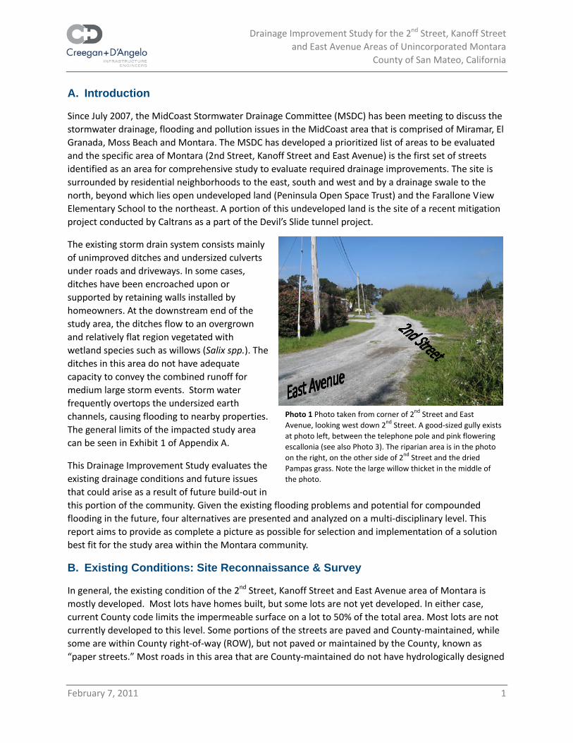
Photo 1 Photo taken from corner of 2nd Street and East Avenue, looking west down 2nd Street. A good‐sized gully exists at photo left, between the telephone pole and pink flowering escallonia (see also Photo 3). The riparian area is in the photo on the right, on the other side of 2nd Street and the dried Pampas grass. Note the large willow thicket in the middle of the photo.
0BA. Introduction
Since July 2007, the MidCoast Stormwater Drainage Committee (MSDC) has been meeting to discuss the stormwater drainage, flooding and pollution issues in the MidCoast area that is comprised of Miramar, El Granada, Moss Beach and Montara. The MSDC has developed a prioritized list of areas to be evaluated and the specific area of Montara (2nd Street, Kanoff Street and East Avenue) is the first set of streets identified as an area for comprehensive study to evaluate required drainage improvements. The site is surrounded by residential neighborhoods to the east, south and west and by a drainage swale to the north, beyond which lies open undeveloped land (Peninsula Open Space Trust) and the Farallone View Elementary School to the northeast. A portion of this undeveloped land is the site of a recent mitigation project conducted by Caltrans as a part of the Devil’s Slide tunnel project.
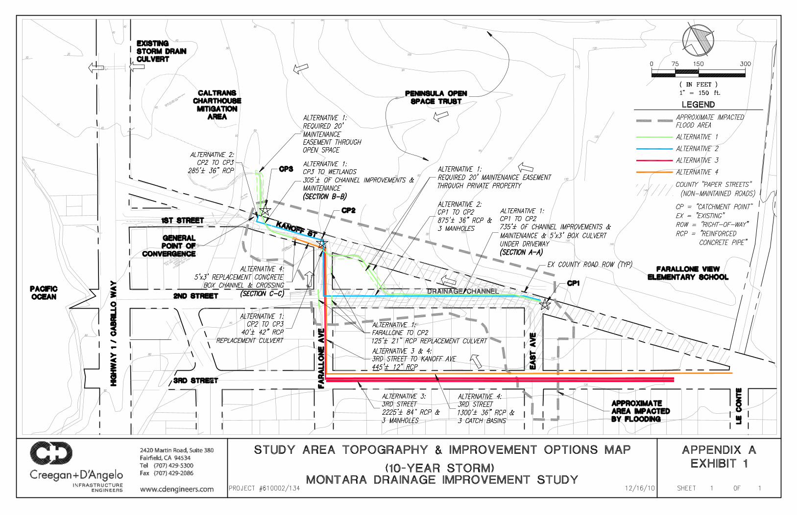
The existing storm drain system consists mainly of unimproved ditches and undersized culverts under roads and driveways. In some cases, ditches have been encroached upon or supported by retaining walls installed by homeowners. At the downstream end of the study area, the ditches flow to an overgrown and relatively flat region vegetated with wetland species such as willows (Salix spp.). The ditches in this area do not have adequate capacity to convey the combined runoff for medium large storm events. Storm water frequently overtops the undersized earth channels, causing flooding to nearby properties. The general limits of the impacted study area can be seen in Exhibit 1 of Appendix A.
This Drainage Improvement Study evaluates the existing drainage conditions and future issues that could arise as a result of future build‐out in this portion of the community. Given the existing flooding problems and potential for compounded flooding in the future, four alternatives are presented and analyzed on a multi‐disciplinary level. This report aims to provide as complete a picture as possible for selection and implementation of a solution best fit for the study area within the Montara community.
1BB. Existing Conditions: Site Reconnaissance & Survey
In general, the existing condition of the 2nd Street, Kanoff Street and East Avenue area of Montara is mostly developed. Most lots have homes built, but some lots are not yet developed. In either case, current County code limits the impermeable surface on a lot to 50% of the total area. Most lots are not currently developed to this level. Some portions of the streets are paved and County‐maintained, while some are within County right‐of‐way (ROW), but not paved or maintained by the County, known as “paper streets.” Most roads in this area that are County‐maintained do not have hydrologically designed

Drainage Improvement Study for the 2nd Street, Kanoff Street and East Avenue Areas of Unincorporated Montara
County of San Mateo, California
February 7, 2011 2
storm drain systems. The extents of County‐maintained ROW and “paper streets” can be seen in Exhibit 1 of Appendix A.
Much of the residential area to the south and east of the study area is steeply sloped toward a convergence point just north of 1st Street, where the topography flattens out quickly before crossing north to the open space and the wetland mitigation area recently improved by Caltrans as a part of the Devil’s Slide project. In addition to the ditches alongside most streets in this area, there is a drainage channel/small unnamed tributary along the north edge of this residential area, lying within the County’s right‐of‐way for Kanoff and 2nd Streets (see Photo 1). A basic exhibit of the topography at the project site is included in this report as Exhibit 1 of Appendix A and a general outline of the area affected by flooding shown.
2BC. Geotechnical Research & Exploration
A geotechnical Preliminary Site Assessment has been conducted by BSK for this site. The complete Assessment is included as Appendix B of this report. The Assessment included site reconnaissance and a literature review of any available existing geotechnical reports, investigations, or information of any sort. No existing reports and very little documented site data were found. However, with the available information for the area in general and observations from the site walk, some general assumptions were made. First, an infiltration system for stormwater management is not likely to be a feasible solution due to low permeability of the soils in this area. Second, there are no apparent unusual conditions that would cause complications for construction of any typical selected stormwater solution. Third, the groundwater level is expected to be highly variable, depending on the season.
As the title indicates, the Assessment is preliminary in nature. When a drainage improvement option is selected for design and installation, a more complete geotechnical investigation is recommended for use at that time. Any of the stormwater management solutions presented by this study are expected to be feasible from a geotechnical standpoint.
3BD. Hydrology/Hydraulic Analysis
The hydraulic analysis for the project site has been based on a combination of the topographic information provided by the County and basic field survey conducted for this study. Analysis has been completed for 10‐, 25‐, 50‐ and 100‐year frequency storm events, as well as for four potential improvement solutions. Improvements required for the 10‐year storm for each alternative are illustrated in Exhibit 1 of Appendix A of this report. The complete hydraulic analysis and more detailed description of each alternative are attached to this report as Appendix C.
The four most viable improvement solutions which are detailed in this report and appendices include:
• Improving Existing Drainage Facilities • Installation of an Underground Storm Drain System Parallel to the existing surface features • Underground Storage of Excess Flow • Hybrid solution of Storage and Conveyance
As the preliminary Geotechnical Assessment indicates, the soils in this area do not appear to favor an underground infiltration system solution. Additionally, we are not considering this as an option at this

Drainage Improvement Study for the 2nd Street, Kanoff Street and East Avenue Areas of Unincorporated Montara
County of San Mateo, California
February 7, 2011 3
time because of the presence of the wetland area north of the site. Since this wetland area is a recent improvement installed as Caltrans’ mitigation measure for the Devil’s Slide project, we are assuming that its design was based on the watershed hydrology in its present state and would therefore depend on the approximate present level of water being delivered to the site. If an infiltration system were installed as a solution to the flooding problems in the neighborhood, a significant amount of water would be diverted from the wetland and could compromise its health. Each of the alternatives studied here would maintain the same volume of flow to the wetland, but potentially modify the rate of delivery only.
Given right‐of‐way issues and the steep topography, surface storage is not considered particularly feasible, so this alternative was considered but deemed infeasible for this Drainage Improvement Study.
During the course of investigation for this report, it was discovered that there are plans with the County Roads Department for replacement of the two culverts crossing 3rd Street at Farallone and the culvert crossing Farallone at Kanoff. No specific details are available at the time of this report writing, and it appears that the replacements are a part of the standard maintenance of structures. No specific study or review has been conducted in association with the plans for replacement. If funds exist for the replacement of these pipes, it is the recommendation of this report that the plans for replacement be studied in accordance with the model set up for this Drainage Improvement Study before installation.
Brief descriptions of the four studied alternatives follow here.
Alternative 1: Improving Existing Drainage Facilities
Since the existing storm drain facilities are currently undersized, as evidenced by the recurrent regional flooding, one alternative would be to upgrade the existing facilities as required to pass the peak flows for a given return period. Based on the desired level of improvement, the existing system could be upgraded to accommodate storm flow by increasing capacities of existing ditches and installing larger pipes under roadway crossings within the study area.
To install the most downstream portion of Alternative 1 as detailed in the hydrology report would require an easement, encroachment permit, or land acquisition from the Peninsula Open Space Trust in order to make the channel improvements recommended for the final segment of flow prior to entering the wetlands. This may not be an easy, inexpensive or even possible option. However, Alternative 1 could also be installed without the channel improvements downstream of Catchment Point 3 (CP3) and convey through the 10‐year storm.
Alternatives 1 and 2 both rely on improvements between Catchment Points 1 and 2 that may be varied in their precise alignment. The existing drainage channel in the vicinity of CP1 begins uphill of CP1 along the Kanoff Street “paper street” right‐of‐way. It then turns northwest down 2nd Street for a short while before turning northeast through two private property parcels to again continue down the Kanoff Street “paper street” right‐of‐way. The portion of the channel running through the private parcels appears to be currently maintained in a nicely landscaped manner which, while aesthetically pleasing, does not afford adequate capacity for high flow volumes. For this portion of the channel, there is the second option of connecting and improving the existing segments of channel within the Kanoff Street right‐of‐way, by continuing along Kanoff Street to the east of the private property. Either improving the channel through its existing alignment or continuing it through the Kanoff Street alignment would involve work
Drainage Improvement Study for the 2nd Street, Kanoff Street and East Avenue Areas of Unincorporated Montara
County of San Mateo, California
February 7, 2011 4
and maintenance within “paper streets.” However, maintaining the current alignment would also involve work and maintenance through private property, which is potentially an even less‐desirable solution for both the County and the landowners. Connecting the channel along the Kanoff Street alignment would allow the majority of the water to flow in an unobstructed path in County right‐of‐way. Design could be accomplished to allow a smaller portion of the flow to continue on its current path through the private property, if so desired by the landowners and the County.
Since Alternative 1 would rely, in part, on installation of facilities, and then maintenance of those facilities, within a “paper street,” an alternative source of funding would be required in order to finance these activities. The current legislation does not allow County funds to pay for installation or maintenance of facilities in “paper streets.”
Alternative 2: Installation of a Parallel Underground Storm Drain System
A second feasible alternative is to supplement the existing undersized storm drain system with a parallel system of sufficient capacity. New pipes would be installed within existing County right‐of‐way in maintained roadways and “paper streets” from the intersection of East Avenue/Kanoff Street/Second Street, to the west on Second Street, north on Farallone Avenue to Kanoff Street, and west on Kanoff Street to the final discharge point to the wetlands to the north. Improvements required for the 10‐year storm are illustrated in Exhibit 1 of Appendix A of this report.
Alternative 3: Underground Storage of Excess Flow
The third alternative evaluated by this report is the augmentation of the existing storm drain capacity with underground storm water storage. While specific points of the existing system cannot handle the peak flows, an underground storage system could be installed upstream of these points within public right‐of‐way. Storm water would be metered out through the existing system after the peak flows have passed and flooding would be avoided for storms up to the desired design level. Several different commercially available products are available that could provide this capacity. The required volume would depend on the desired level of protection, and detailed analysis for the 10, 25, 50 and 100‐year storm events is provided in Appendix C. Improvements required for the 10‐year storm are illustrated in Exhibit 1 of Appendix A of this report.
Alternative 3 is expected to be the most costly solution by far of any of the proposed options.
Alternative 4: Combination of Storage and Conveyance of flow
A variation on Alternatives 1 through 3 was also evaluated by this report and is a combination of storm water storage and conveyance solutions. Since the most limiting feature at the downstream end of the study area is the culvert in front of the home at the north end of Kanoff, just prior to the wetland area, increasing the size of this culvert and the associated channel can allow storm water to be conveyed off the site at a much greater rate. One segment of 36” pipe could also be installed in 3rd Street to store some water until it is able to flow out the improved channel downstream.

Drainage Improvement Study for the 2nd Street, Kanoff Street and East Avenue Areas of Unincorporated Montara
County of San Mateo, California
February 7, 2011 5
Photo 2. Looking east from the corner of 2nd Street and East Avenue. Note that the riparian area is on the other side of the street (outside of photo left), and also note the gullying in middle of photo.
Photo 3. Photo taken just north of and across 2nd Street from Photo 2, showing the riparian area and open space/upland habitat beyond. Note that the area is severely gullying, and that the large dead grasses are nonnative Pampas grass.
This solution lends itself well to phasing, as the culvert and channel improvements could be made first, and the 36” storage pipe added at a later date. While in entirety, Alternative 4 is not the least expensive option. However, the option for phasing, as well as the lack of required right‐of‐way, the fact that the work would be entirely within currently maintained right‐of‐way, and the relatively minor expected environmental work, make this solution possibly the most desirable alternative for this storm water problem.
4BE. Existing Biological Conditions
A biological site reconnaissance was performed by TRA Environmental Sciences, Inc. on April 13, 2010, for this study. As stated above in “Section B. Existing Conditions,” the 2nd Street, Kanoff Street and East Avenue area of Montara is “mostly developed” (urbanized), and does not contain undeveloped wildlife habitat. These urbanized areas support few native habitats and support wildlife species adapted to urban environments, such as raccoon (Procyon lotor), striped skunk (Mephitis mephitis), opossum (Didelphis virginiana), house sparrow (Passer domesticus), house finch (Carpodacus mexicanus), and brown towhee (Pipilo crissalis). Because Montara is surrounded by open space, several other wildlife species, such as black‐tailed deer (Odocoilus hermionus) and bobcat (Lynx rufus), could occur there but are not likely to depend on the habitat for forage or breeding.
The study area is in the northwestern portion of Montara, and is at the edge of one of the largest open space tracts of land on the San Francisco Peninsula. Immediately north and east of Montara are numerous designated open spaces and parks, including the 4,262‐acre Rancho Corral de Tierra unit currently administered by the Peninsula Open Space Trust (POST), and Montara State Beach, which includes Montara Mountain (also called McNee Ranch). Montara Mountain is a northern spur of the Santa Cruz Mountains and features the only undisturbed coastal mountain habitat found over 100 miles of coastline (California State Parks 2010).
In addition to urban uses, the project area contains a small unnamed intermittent creek/drainage ditch and riparian area just north of the residential area on 2nd Street between Farallone/Kanoff Street and East Avenue (see Photos 1‐3). Just north of this
Drainage Improvement Study for the 2nd Street, Kanoff Street and East Avenue Areas of Unincorporated Montara
County of San Mateo, California
February 7, 2011 6
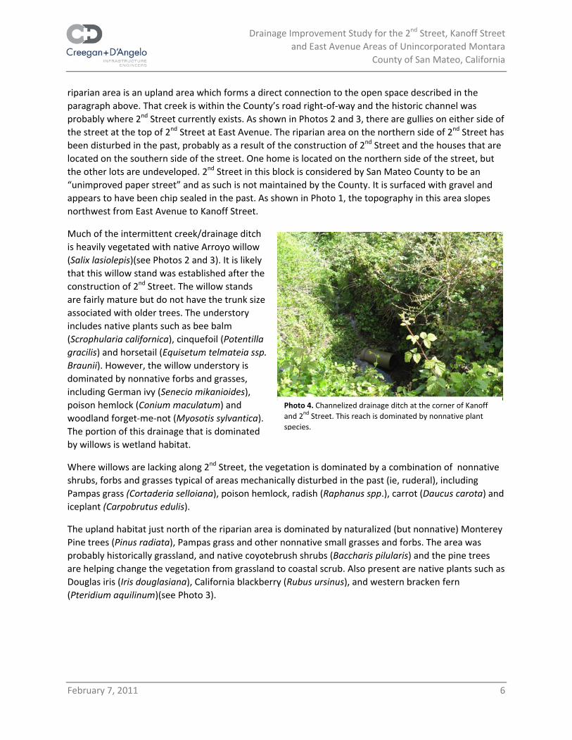
Photo 4. Channelized drainage ditch at the corner of Kanoff and 2nd Street. This reach is dominated by nonnative plant species.
riparian area is an upland area which forms a direct connection to the open space described in the paragraph above. That creek is within the County’s road right‐of‐way and the historic channel was probably where 2nd Street currently exists. As shown in Photos 2 and 3, there are gullies on either side of the street at the top of 2nd Street at East Avenue. The riparian area on the northern side of 2nd Street has been disturbed in the past, probably as a result of the construction of 2nd Street and the houses that are located on the southern side of the street. One home is located on the northern side of the street, but the other lots are undeveloped. 2nd Street in this block is considered by San Mateo County to be an “unimproved paper street” and as such is not maintained by the County. It is surfaced with gravel and appears to have been chip sealed in the past. As shown in Photo 1, the topography in this area slopes northwest from East Avenue to Kanoff Street.
Much of the intermittent creek/drainage ditch is heavily vegetated with native Arroyo willow (Salix lasiolepis)(see Photos 2 and 3). It is likely that this willow stand was established after the construction of 2nd Street. The willow stands are fairly mature but do not have the trunk size associated with older trees. The understory includes native plants such as bee balm (Scrophularia californica), cinquefoil (Potentilla gracilis) and horsetail (Equisetum telmateia ssp. Braunii). However, the willow understory is dominated by nonnative forbs and grasses, including German ivy (Senecio mikanioides), poison hemlock (Conium maculatum) and woodland forget‐me‐not (Myosotis sylvantica). The portion of this drainage that is dominated by willows is wetland habitat.
Where willows are lacking along 2nd Street, the vegetation is dominated by a combination of nonnative shrubs, forbs and grasses typical of areas mechanically disturbed in the past (ie, ruderal), including Pampas grass (Cortaderia selloiana), poison hemlock, radish (Raphanus spp.), carrot (Daucus carota) and iceplant (Carpobrutus edulis).
The upland habitat just north of the riparian area is dominated by naturalized (but nonnative) Monterey Pine trees (Pinus radiata), Pampas grass and other nonnative small grasses and forbs. The area was probably historically grassland, and native coyotebrush shrubs (Baccharis pilularis) and the pine trees are helping change the vegetation from grassland to coastal scrub. Also present are native plants such as Douglas iris (Iris douglasiana), California blackberry (Rubus ursinus), and western bracken fern (Pteridium aquilinum)(see Photo 3).

Drainage Improvement Study for the 2nd Street, Kanoff Street and East Avenue Areas of Unincorporated Montara
County of San Mateo, California
February 7, 2011 7
Photo 5. Looking at the southwest corner where Kanoff Street changes from north/south to east/west. Note the large willow thicket in the photo background that identifies this as a wetland.
Photo 6. Looking at the northeast corner where Kanoff Street turns to Farallone Avenue to photo right. Note the large willow thicket in the photo background.
Bird species observed in the riparian habitat at the time of the site visit included American goldfinch (Carduelis tristis), golden‐crowned sparrow (Zonotrichia atricapilla), and Anna’s hummingbird (Calypte anna). No evidence of raptor nesting was found. Raptors typically nest in tall trees, and given the size of the willow thicket, there is a small potential for raptors to nest in these trees. However, raptors could nest in the Monterey pine trees in the adjacent grassland/scrubland. No special‐status species were observed during the site survey, however, California red‐legged frog (Rana aurora draytonii) and San Francisco garter snake (Thamnophis sirtalis tetrataenia) occur in the region (California Natural Diversity Database search April 12, 2010), and the willow riparian could provide cover for these species. The willow riparian area and adjacent annual grassland/scrub habitat could support both nesting birds and the San Francisco dusky‐footed woodrat (California Department of Fish and Game species of special concern). Surveys for these species will need to be performed as part of this Drainage Study process.
At the corner of 2nd Street and Kanoff Street, the drainage ditch is channelized into a concrete “U” shaped ditch (see Photo 4). This reach is downstream of the area that contains the arroyo willow and ruderal vegetation. The vegetation in this reach is dominated by nonnative, invasive plants such as blackberry (Rubus discolor), German ivy, periwinkle (Vinca minor), and Algerian ivy (Hedera helix), has little habitat value, and there is no natural drainage channel.
The western end of the study area at Kanoff Street is the lowest point in elevation of the entire study area (see Photo 5). Just west of the residence at Kanoff Street is another wetland area, dominated by native willows, nonnative blackberries and German ivy (see Photo 5). This wetland area connects to the blue line creek shown on the USGS Montara Mountain quadrangle, and also connects to the newly created wetland mitigation pond created by Caltrans. It is also hydrologically connected to the large willow thicket in the natural area just east of the corner where Kanoff Street turns to Farallone Avenue (see Photo 6).

Drainage Improvement Study for the 2nd Street, Kanoff Street and East Avenue Areas of Unincorporated Montara
County of San Mateo, California
February 7, 2011 8
5BF. Environmental Review
We have identified a list of permits that may be required by the potential solution options, the conditions which would trigger those permits, and the expected timeframe to process and gain each permit. See Table 1, below, for this listing. All permits may be processed simultaneously to reduce overall required time for permits to be received. The table also includes estimated costs for obtaining each permit. The estimated costs include the consulting and permit fees required, but not any potential mitigation fees. The required means and extent of mitigation are unknown at this stage.
Since the project area is located within the San Mateo County’s coastal zone, a report answering the questions on the Biological Impact Form pursuant to Local Coastal Program (LCP) Policy 7.5 will be prepared for submission to the County’s Planning and Building Division. The report will include an analysis of the proposed project’s biological impacts. The report will partially fulfill the environmental review requirements of the San Mateo County Local Coastal Program and the California Environmental Quality Act (CEQA). In addition, a CEQA analysis will be completed on the selected preferred alternative. The CEQA analysis will take the form of a mitigated negative declaration or an environmental impact report, depending on the outcome of an Initial Study. As stated in San Mateo County’s Guidelines for the Preparation of Biological Impact Reports, the definition of a Sensitive Habitat is an area in which plant or animal life or their habitats are either rare or especially valuable and those areas which meet one of the following criteria: (1) habitats containing or supporting “rare or endangered” species as defined by the State Fish and Game Commission, (2) all perennial and intermittent streams and their tributaries, (3) Coastal tidelands and marshes, (4) coastal and offshore areas containing breeding and/or nesting sites and coastal areas used by migratory and resident water‐associated birds for resting and feeding, (5) areas used for scientific study and research concerning fish and wildlife, (6) lakes and ponds and adjacent shore habitat, (7) existing game and wildlife refuges and reserves, and (8) sand dunes. Such areas include riparian areas, wetlands, sand dunes, marine habitats, sea cliffs, and habitats supporting rare, endangered and unique species.

Drainage Improvement Study for the 2nd Street, Kanoff Street and East Avenue Areas of Unincorporated Montara
County of San Mateo, California
February 7, 2011 9
Table 1 Permits That May Be Required
Type of Permit Trigger Estimated
Timeframe Estimated Cost
Alternativesthat could Require Permit
USACE Nationwide Permit (s)
Construction activities within U.S. Army Corps of Engineers' jurisdiction (waters of the U.S. and/or wetlands)
With Endangered Species Section 7 consultation about 6‐8 months; less if Section 7 is not required
$5,000‐20,000
1, 3, 4 and possibly 2
Biological Assessment for California red‐legged frog (federal threatened) and San Francisco garter snake (federal endangered; state endangered; state fully‐protected)
Project related activities that could result in take of federally or state listed species requires authorization from the U.S. Fish and Wildlife Service for federally listed species and the California Department of Game for state listed species. A Biological Assessment is part of the request for take authorization.
6‐8 weeks $5,000 1‐4
Section 7 Consultation with the USFWS
Project removes federally‐listed species or habitats, and requires a permit from another federal agency, such as the U.S. Army Corps of Engineers. Project activities in the willow riparian areas could trigger this.
4‐6 months to complete process
$5,000 1‐4
ESA Section 10 permit If the project results in the take of federally listed species and no other federal authorization is required.
Several years(unknown)
>$25,000 unknown
Coastal Development Permit from County Planning
This would be triggered if the project impacts riparian vegetation. LCP limit of riparian vegetation is listed as 30 feet for intermittent streams. Where no riparian vegetation exists along both sides of riparian corridors, the trigger would be construction within 30 feet from the predictable high water point to the midpoint of intermittent streams.
6 months $5,000‐$7,500
1‐4

Drainage Improvement Study for the 2nd Street, Kanoff Street and East Avenue Areas of Unincorporated Montara
County of San Mateo, California
February 7, 2011 10
Type of Permit Trigger Estimated Timeframe
Estimated Cost
Alternativesthat could Require Permit
Regional Water Quality Control Board water quality certification; Construction General Permit; stormwater discharge permits
1. Water quality certification is required if a permit is issued by the U.S. Army Corps of Engineers. Construction activities subject to the Construction General Permit include clearing, grading and disturbances to the ground such as stockpiling, or excavation, but does not include regular maintenance activities performed to restore the original line, grade, or capacity of the facility.
2‐6 months $5,000 1, 3, 4 and possibly 2
2. Water quality certification is required for Small Linear Underground/ Overhead Projects that disturb at least 1 acre. For this certification, the project cannot be larger than 5 acres (including trenching and staging areas)
Projects less than 5 acres are covered by the Statewide General Permit for Storm Water Discharges Associated with Construction Activity from Small Linear Underground/Overhead Projects (Small LUP General Permit). The Small LUP General Permit has varying application and permitting requirements based on the type and complexity of the project.
2‐6 months
California Department of Fish and Game, Streambed Alteration Notification
Project activities that affect the bed, bank or channel of any river, stream or lake.
1‐2 months $3,000‐$5,000
1‐4
California Department of Fish and Game, California Endangered Species Act, 2081 Permit.
Project activities that affect the San Francisco Garter Snake would trigger a permit under the California Endangered Species Act. However, because the garter snake is also state fully protected, take authorization cannot be granted. Therefore, project activities must avoid take.
1‐2 months $3,000‐$5,000
1‐4

Drainage Improvement Study for the 2nd Street, Kanoff Street and East Avenue Areas of Unincorporated Montara
County of San Mateo, California
February 7, 2011 11
6BG. Cost Estimate
At this stage in the study of options, a preliminary cost estimate is useful in gauging the approximate order of magnitude associated with different improvement choices. Using the items and quantities presented in the Draft Hydrology Technical Memorandum included in Appendix C of this report, the following costs represent the estimated installation costs associated with each improvement option for a level of protection to convey or contain up to either a 10‐year or a 25‐year storm. Installation will include items such as mobilization of workers and equipment, excavation, storage, and/or off‐haul of soil, material costs, and repair of existing streets and utilities affected by the work. The following assumptions were also made:
• Preliminary maintenance cost estimates are based on the assumption that the County will provide maintenance through their existing maintenance program
• A 25% contingency/inflation factor is added into the installation costs
• The Replacement Reserve Funds allotment is based on an estimated lifespan for Reinforced Concrete Pipe (RCP) of 30 years
• Most proposed improvements will be made within County Right‐of‐Way, so no costs are associated with right‐of‐way acquisition; if Alternative 1 is selected and depending on the final design, there may be a need to purchase right‐of‐way or an easement through two private parcels between Kanoff Street and 2nd Street and in the Peninsula Open Space for swale construction and maintenance
• Potential costs of permitting associated with each alternative are not included here since it is not definitive at this point which permits would be required. Additionally, potential costs of any mitigation are not yet defined since mitigation requirements are not yet defined.
• Catchment Points (CP) are illustrated on Exhibit 1 of Appendix A and are discussed fully in Appendix C; Channel Sections A‐A, B‐B and C‐C are as located on Exhibit 1 of Appendix A and are illustrated on Exhibit 2 of Appendix A.

Drainage Improvement Study for the 2nd Street, Kanoff Street and East Avenue Areas of Unincorporated Montara
County of San Mateo, California
February 7, 2011 12
TABLE 2 – 10 Year Remediation Quantities & Estimates
Alternative 1 ‐ Improving Existing Drainage Facilities Reach Item Quantity Units Unit Cost Item Cost CP1 to CP2 Channel Improvements – Section A‐A 720 CY $ 40 $ 28,800
5’x3’ Reinforced Concrete Box Culvert 1 LS $ 7,500 $ 7,500 Farallone to CP2 21" RCP Replacement Culvert 125 LF $ 150 $ 18,750 CP2 to CP3 42" RCP Replacement Culvert 40 LF $ 225 $ 9,000 CP3 to Wetland Channel Improvements – Section B‐B 500 CY $ 40 $ 20,000 Design 1 LS $ 15,000 $ 15,000
Right‐of‐Way 1 LS Unknown Estimated Permits 1 LS $ 49,500 $ 49,500
Mobilization 1 LS $ 7,650 $ 7,650 Construction Management 1 LS $ 9,500 $ 9,500
Alternative 1 Installation Cost $ 165,700 Expected Annual Maintenance $ 4,500 per year Annual Replacement Reserve Funds $ 8,800 per year
Alternative 2 ‐ Constructing a Parallel Underground Conveyance System Reach Item Quantity Units Unit Cost Total Cost CP1 to CP2 36" RCP 875 LF $ 200 $ 175,000
Manhole 3 EA $ 2,000 $ 6,000 CP2 to CP3 36" RCP 285 LF $ 200 $ 57,000 Design 1 LS $ 37,500 $ 37,500
Estimated Permits 1 LS $ 49,500 $ 49,500 Mobilization 1 LS $ 20,000 $ 20,000 Construction Management 1 LS $ 25,000 $ 25,000
Alternative 2 Installation Cost $ 370,000 Expected Annual Maintenance $ 1,500 per year Annual Replacement Reserve Funds $ 24,500 per year
Alternative 3 ‐ Storing Excess Water Reach Item Quantity Units Unit Cost Total Cost 3rd Street 84" RCP 2225 LF $ 325 $ 723,125
Manhole 3 EA $ 2,000 $ 6,000 3rd Street to Kanoff 12" RCP 445 LF $ 150 $ 66,750 Design 1 LS $ 148,100 $ 148,100
Estimated Permits 1 LS $ 49,500 $ 49,500 Mobilization 1 LS $ 78,990 $ 78,990 Construction Management 1 LS $ 98,735 $ 98,735
Alternative 3 Installation Cost $ 1,171,200 Expected Annual Maintenance $ 2,000 per year Annual Replacement Reserve Funds $ 86,500 per year
Drainage Improvement Study for the 2nd Street, Kanoff Street and East Avenue Areas of Unincorporated Montara
County of San Mateo, California
February 7, 2011 13
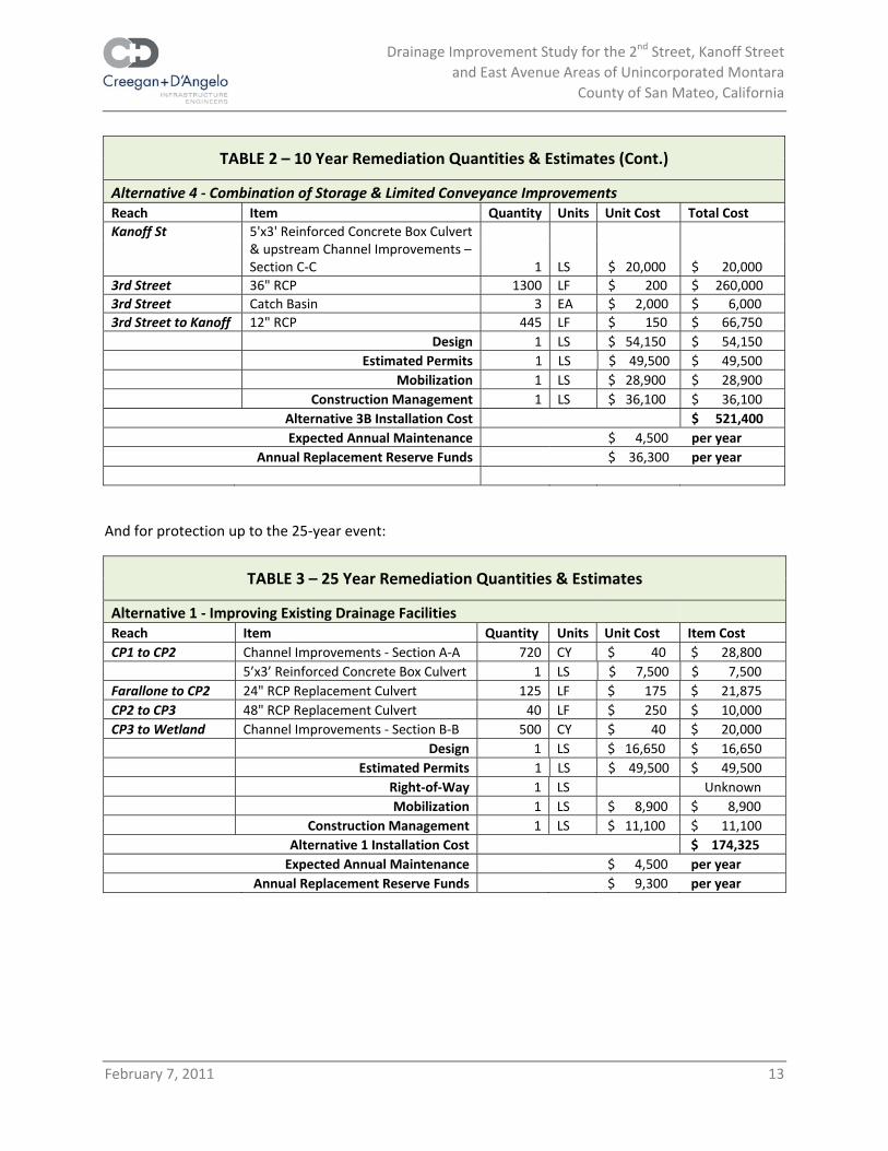
TABLE 2 – 10 Year Remediation Quantities & Estimates (Cont.)
Alternative 4 ‐ Combination of Storage & Limited Conveyance Improvements Reach Item Quantity Units Unit Cost Total Cost Kanoff St 5'x3' Reinforced Concrete Box Culvert
& upstream Channel Improvements – Section C‐C 1 LS $ 20,000 $ 20,000
3rd Street 36" RCP 1300 LF $ 200 $ 260,0003rd Street Catch Basin 3 EA $ 2,000 $ 6,000 3rd Street to Kanoff 12" RCP 445 LF $ 150 $ 66,750 Design 1 LS $ 54,150 $ 54,150
Estimated Permits 1 LS $ 49,500 $ 49,500 Mobilization 1 LS $ 28,900 $ 28,900 Construction Management 1 LS $ 36,100 $ 36,100
Alternative 3B Installation Cost $ 521,400 Expected Annual Maintenance $ 4,500 per year Annual Replacement Reserve Funds $ 36,300 per year
And for protection up to the 25‐year event:
TABLE 3 – 25 Year Remediation Quantities & Estimates
Alternative 1 ‐ Improving Existing Drainage Facilities Reach Item Quantity Units Unit Cost Item Cost CP1 to CP2 Channel Improvements ‐ Section A‐A 720 CY $ 40 $ 28,800
5’x3’ Reinforced Concrete Box Culvert 1 LS $ 7,500 $ 7,500 Farallone to CP2 24" RCP Replacement Culvert 125 LF $ 175 $ 21,875 CP2 to CP3 48" RCP Replacement Culvert 40 LF $ 250 $ 10,000 CP3 to Wetland Channel Improvements ‐ Section B‐B 500 CY $ 40 $ 20,000 Design 1 LS $ 16,650 $ 16,650
Estimated Permits 1 LS $ 49,500 $ 49,500 Right‐of‐Way 1 LS Unknown Mobilization 1 LS $ 8,900 $ 8,900 Construction Management 1 LS $ 11,100 $ 11,100
Alternative 1 Installation Cost $ 174,325 Expected Annual Maintenance $ 4,500 per year Annual Replacement Reserve Funds $ 9,300 per year
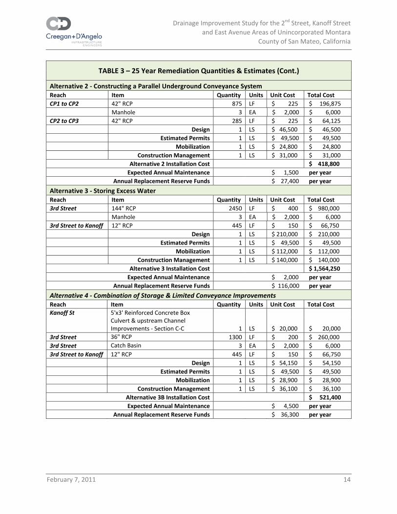
Drainage Improvement Study for the 2nd Street, Kanoff Street and East Avenue Areas of Unincorporated Montara
County of San Mateo, California
February 7, 2011 14
TABLE 3 – 25 Year Remediation Quantities & Estimates (Cont.)
Alternative 2 ‐ Constructing a Parallel Underground Conveyance System Reach Item Quantity Units Unit Cost Total Cost CP1 to CP2 42" RCP 875 LF $ 225 $ 196,875
Manhole 3 EA $ 2,000 $ 6,000 CP2 to CP3 42" RCP 285 LF $ 225 $ 64,125 Design 1 LS $ 46,500 $ 46,500
Estimated Permits 1 LS $ 49,500 $ 49,500 Mobilization 1 LS $ 24,800 $ 24,800 Construction Management 1 LS $ 31,000 $ 31,000
Alternative 2 Installation Cost $ 418,800 Expected Annual Maintenance $ 1,500 per year Annual Replacement Reserve Funds $ 27,400 per year
Alternative 3 ‐ Storing Excess Water Reach Item Quantity Units Unit Cost Total Cost 3rd Street 144" RCP 2450 LF $ 400 $ 980,000
Manhole 3 EA $ 2,000 $ 6,000 3rd Street to Kanoff 12" RCP 445 LF $ 150 $ 66,750 Design 1 LS $ 210,000 $ 210,000
Estimated Permits 1 LS $ 49,500 $ 49,500 Mobilization 1 LS $ 112,000 $ 112,000 Construction Management 1 LS $ 140,000 $ 140,000
Alternative 3 Installation Cost $ 1,564,250 Expected Annual Maintenance $ 2,000 per year Annual Replacement Reserve Funds $ 116,000 per year
Alternative 4 ‐ Combination of Storage & Limited Conveyance Improvements Reach Item Quantity Units Unit Cost Total Cost Kanoff St 5'x3' Reinforced Concrete Box
Culvert & upstream Channel Improvements ‐ Section C‐C 1 LS $ 20,000 $ 20,000
3rd Street 36" RCP 1300 LF $ 200 $ 260,000 3rd Street Catch Basin 3 EA $ 2,000 $ 6,000 3rd Street to Kanoff 12" RCP 445 LF $ 150 $ 66,750 Design 1 LS $ 54,150 $ 54,150
Estimated Permits 1 LS $ 49,500 $ 49,500 Mobilization 1 LS $ 28,900 $ 28,900 Construction Management 1 LS $ 36,100 $ 36,100
Alternative 3B Installation Cost $ 521,400 Expected Annual Maintenance $ 4,500 per year Annual Replacement Reserve Funds $ 36,300 per year
Drainage Improvement Study for the 2nd Street, Kanoff Street and East Avenue Areas of Unincorporated Montara
County of San Mateo, California
February 7, 2011 15
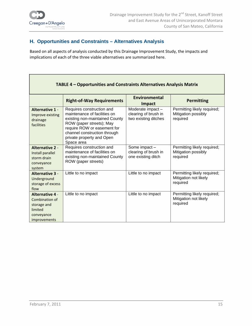
7BH. Opportunities and Constraints – Alternatives Analysis
Based on all aspects of analysis conducted by this Drainage Improvement Study, the impacts and implications of each of the three viable alternatives are summarized here.
TABLE 4 – Opportunities and Constraints Alternatives Analysis Matrix
Right‐of‐Way Requirements Environmental
Impact Permitting
Alternative 1 ‐ Improve existing drainage facilities
Requires construction and maintenance of facilities on existing non-maintained County ROW (paper streets); May require ROW or easement for channel construction through private property and Open Space area
Moderate impact – clearing of brush in two existing ditches
Permitting likely required; Mitigation possibly required
Alternative 2 ‐ Install parallel storm drain conveyance system
Requires construction and maintenance of facilities on existing non-maintained County ROW (paper streets)
Some impact – clearing of brush in one existing ditch
Permitting likely required; Mitigation possibly required
Alternative 3 ‐ Underground storage of excess flow
Little to no impact Little to no impact Permitting likely required; Mitigation not likely required
Alternative 4 ‐ Combination of storage and limited conveyance improvements
Little to no impact Little to no impact Permitting likely required; Mitigation not likely required

Drainage Improvement Study for the 2nd Street, Kanoff Street and East Avenue Areas of Unincorporated Montara
County of San Mateo, California
February 7, 2011 16
TABLE 4 – Opportunities and Constraints Alternatives Analysis Matrix (Cont.)
Life
Cycle/Maintenance Constructability/Phasing
Order of Magnitude
Construction Cost Alternative 1 ‐ Improve existing drainage facilities
Recurrent maintenance of channels to prevent establishment of woody vegetation
Moderate impact to traffic flow; reasonably constructible; could be phased as funding becomes available
$
Alternative 2 ‐ Install parallel storm drain conveyance system
Recurrent maintenance of channels to prevent establishment of woody vegetation
Moderate impact to traffic flow; reasonably constructible; could be phased as funding becomes available
$$
Alternative 3 ‐ Underground storage of excess flow
Maintenance of storage chambers and RCP as recommended by manufacturer
Moderate impact to traffic flow; reasonably constructible; could be phased as funding becomes available
$$$$$
Alternative 4 ‐ Combination of storage and limited conveyance improvements
Maintenance of RCP as recommended by manufacturer
Moderate impact to traffic flow; reasonably constructible; could be phased as funding becomes available
$$$
8BI. Recommendations on Preferred Solution
As mentioned above, Alternatives 1 and 2 both rely in part on installation of facilities and then maintenance of those facilities, within paper streets. Since the current legislation does not allow County funds to pay for installation or maintenance of facilities in paper streets, an alternative source of funding would be required in order to finance these activities. This is not a desirable situation. Additionally, a portion of improvements as recommended for Alternative 1 would require land acquisition of some sort from the Peninsula Open Space Trust, which may or may not be a possibility of achieving.
Alternative 3 does not have the right‐of‐way or land acquisition issues, or even many expected environmental issues, however, the cost of Alternative 3 makes it prohibitive.
As a hybrid of the other three alternatives, Alternative 4 seems to be the most desirable alternative for the storm water issues studied by this report. Alternative 4 is not the least expensive option; however, it may be phased as funds are available. Additionally, the lack of required right‐of‐way, the fact that the work would be entirely within currently maintained right‐of‐way, and the relatively minor expected environmental work, are all favorable features of this solution.

Drainage Improvement Study for the 2nd Street, Kanoff Street and East Avenue Areas of Unincorporated Montara
County of San Mateo, California
February 7, 2011 17
9BJ. Funding Strategies
Appendix D of this report consists of the complete Technical Memorandum on Funding Strategies, which includes:
• Analysis of existing agency resources with capacity or potential to contribute toward the estimated costs of the drainage improvement alternatives.
• Documentation of enhanced and/or new financing sources for the unfunded costs of the alternatives. Financing sources will include a compilation of external sources, but will focus most specifically on resources within the local control of the County (subject to constituent approval in some cases), which may include any number of exaction types: assessments, special taxes, property‐related fees, and user fees or regulatory fees.
The memorandum gives a more complete picture of the funds required to install, maintain and, in the future, replace, each of the Alternatives described in this report. However, it does not show the specific breakdown of phasing installation. In the end, should the community elect to move forward with any of the improvement alternatives described in this report, the community will also need to decide which funding mechanisms are best for everybody involved.
Drainage Improvement Study for the 2nd Street, Kanoff Street and East Avenue Areas of Unincorporated Montara
County of San Mateo, California
February 7, 2011
Appendix A:
Study Area Topography and Improvement Options Map
(10-year Storm)

Drainage Improvement Study for the 2nd Street, Kanoff Street and East Street Areas of Unincorporated Montara
County of San Mateo, California
February 7, 2011
Appendix B:
Geotechnical Preliminary Site Assessment


Drainage Improvement Study for the 2nd Street, Kanoff Street and East Street Areas of Unincorporated Montara
County of San Mateo, California
February 7, 2011
Appendix C:
Hydrology Technical Memorandum
100 N. Winchester Blvd., Suite 200 Santa Clara, CA 95050
(408) 246-4848 FAX (408) 246-5624
TECHNICAL MEMORANDUM PROJECT: Montara Drainage Improvement Study DATE: June 21, 2010 PREPARED: Charles D. Anderson, PE JOB #: C&DO.02.10 SUBJECT: Evaluation of Hydrologic Conditions near Kanoff Street between East Avenue
and Cabrillo Highway The County of San Mateo is in the process of evaluating local drainage conditions on the northern edge of unincorporated Montara in the vicinity of Second Street, Kanoff Street and East Avenue east of Cabrillo Highway (State Route 1), which is immediately adjacent to the bluff above Montara State Beach. The purpose of this memorandum is to document the estimation of peak runoff rates at several locations and compare these estimates to calculated capacities for existing drainage facilities.
Hydrologic calculations are based on methodologies and data from the 2007 Santa Clara County Drainage Manual (San Mateo County does not publish a drainage manual per se); 2005 orthophotography from the County of San Mateo; and April 2010 field surveys by Creegan + D’Angelo.
Information contained in this technical memorandum will be used to help establish drainage improvement alternatives for this area of Montara.
Watershed Analysis
An HEC hydrograph procedure is used to estimate the 10-, 25-, 50-, and 100-year frequency storm flows for the local watershed following 2007 Santa Clara County methodology. Local watershed boundaries are based on 2005 San Mateo County topographic maps, supplemented by Creegan + D’Angelo field surveys. At County direction, stormwater runoff is modeled based on a worst case scenario of 50 percent impermeable surface conditions on residential lots. That is, with 50 percent of each lot covered by buildings, impermeable driveway, patios or other hard surface that prevents infiltration.
Three points of interest have been used to evaluate drainage catchments, which are shown in Figure 1:
1. The intersection of East Avenue with Second Street.
2. Kanoff Street one block north of Second Street.
3. The end of First Street, east of Cabrillo Highway.

Montara Drainage Study Hydrology -2- June 21, 2010
Figure 1: Catchments Analyzed
Catchment Areas:
1. The intersection of East Avenue with Second Street.
2. Kanoff Street one block north of Second Street.
3. The end of First Street, east of Cabrillo Highway.

Montara Drainage Study Hydrology -3- June 21, 2010
Hydrograph Method
The SCS unit hydrograph procedure as outlined in the Santa Clara County Drainage Manual accounts for hydrologic losses including evaporation, transpiration, infiltration, surface routing, storage within the watershed and varying antecedent moisture conditions. This method involves the development of flood hydrographs using a design storm, an appropriate soil loss function, and a synthetic unit hydrograph. This method is consistent with the HEC-1 and HEC-HMS programs developed by the Hydrologic Engineering Center of the U.S. Army Corps of Engineers.
Design Storms
The standard storm duration for rainfall simulation is 24 hours. Figure 2 shows the adopted (normalized) 24-hour incremental rainfall distribution pattern, which is based upon the three-day December 1955 rainfall event that is still considered the storm of record for northern California. Note that the mean annual precipitation in the Montara watershed is 22.5 inches,1 so the pattern for 20 inches of mean annual precipitation is used. This precipitation pattern has been adjusted to preserve local rainfall statistics in Santa Clara and San Mateo Counties as collected by the Santa Clara Valley Water District. Consequently, the incremental precipitation pattern shown in Figure 2 is balanced so that the 24-hour storm distribution may be used even where shorter duration storms are more critical. Table 1 provides values of precipitation as a percentage of the total 24-hour depth.
Figure 2: 24-hour Precipitation Pattern (Santa Clara County Drainage Manual)
1 USDA Soil Conservation Service, “Soil Survey of San Mateo County, Eastern Part, and San Francisco County, California,” May 1991.

Montara Drainage Study Hydrology -4- June 21, 2010
Table 1 Fractions of Total Rainfall for 24-Hour, 5-Minute Pattern
Time Starting Fraction of
Total Rainfall (%)
Time Starting Fraction of
Total Rainfall (%)
0:00 0.1482 11:00 0.3933
1:00 0.1358 12:00 0.2979
2:00 0.3223 13:00 0.3099
3:00 0.5930 14:00 0.2223
4:00 0.5285 15:00 0.2470
5:00 0.5266 16:00 0.2223
6:00 4.0600 17:00 0.1235
6:10 1.2750 18:00 0.1605
6:30 1.0169 19:00 0.1729
7:00 0.5229 20:00 0.1482
8:00 0.2860 21:00 0.3581
9:00 0.2384 22:00 0.2840
10:00 0.3337 23:00 0.1482
Rainfall totals for the return periods of interest are calculated using the Santa Clara Valley Water District’s Return Period-Duration-Specific (TDS) Regional Equation and summarized in Table 2 for each return period.
MAPBAx DTDTDT ,,, +=
where xT,D = precipitation depth (inches) for a specific return period and storm duration
T = return period (years)
D = storm duration (hours)
AT,D; BT,D = dimensionless coefficients from Table B-1 of the Santa Clara County Manual
MAP = mean annual precipitation (22.5 inches)
Montara Drainage Study Hydrology -5- June 21, 2010
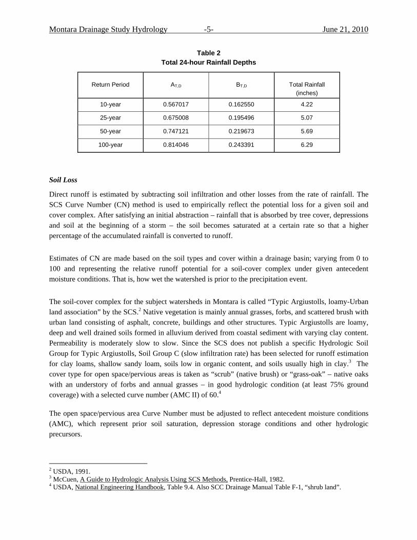
Table 2 Total 24-hour Rainfall Depths
Return Period AT,D BT,D
Total Rainfall
(inches)
10-year 0.567017 0.162550 4.22
25-year 0.675008 0.195496 5.07
50-year 0.747121 0.219673 5.69
100-year 0.814046 0.243391 6.29
Soil Loss
Direct runoff is estimated by subtracting soil infiltration and other losses from the rate of rainfall. The SCS Curve Number (CN) method is used to empirically reflect the potential loss for a given soil and cover complex. After satisfying an initial abstraction – rainfall that is absorbed by tree cover, depressions and soil at the beginning of a storm – the soil becomes saturated at a certain rate so that a higher percentage of the accumulated rainfall is converted to runoff.
Estimates of CN are made based on the soil types and cover within a drainage basin; varying from 0 to 100 and representing the relative runoff potential for a soil-cover complex under given antecedent moisture conditions. That is, how wet the watershed is prior to the precipitation event.
The soil-cover complex for the subject watersheds in Montara is called “Typic Argiustolls, loamy-Urban land association” by the SCS.2 Native vegetation is mainly annual grasses, forbs, and scattered brush with urban land consisting of asphalt, concrete, buildings and other structures. Typic Argiustolls are loamy, deep and well drained soils formed in alluvium derived from coastal sediment with varying clay content. Permeability is moderately slow to slow. Since the SCS does not publish a specific Hydrologic Soil Group for Typic Argiustolls, Soil Group C (slow infiltration rate) has been selected for runoff estimation for clay loams, shallow sandy loam, soils low in organic content, and soils usually high in clay.3 The cover type for open space/pervious areas is taken as “scrub” (native brush) or “grass-oak” – native oaks with an understory of forbs and annual grasses – in good hydrologic condition (at least 75% ground coverage) with a selected curve number (AMC II) of 60.4
The open space/pervious area Curve Number must be adjusted to reflect antecedent moisture conditions (AMC), which represent prior soil saturation, depression storage conditions and other hydrologic precursors.
2 USDA, 1991. 3 McCuen, A Guide to Hydrologic Analysis Using SCS Methods, Prentice-Hall, 1982. 4 USDA, National Engineering Handbook, Table 9.4. Also SCC Drainage Manual Table F-1, “shrub land”.
Montara Drainage Study Hydrology -6- June 21, 2010
The Santa Clara County Drainage Manual establishes an AMC for each storm return period calibrated to individual flood frequency analyses of annual stream discharge data in Santa Clara County, for use with the specific rainfall distribution pattern shown in Figure 2. For the 10-year through 100-year return periods, the calibrated AMC is II½. A Curve Number of 60 for AMC II equates to a Curve Number of 69 for AMC II½.
Urban development is modeled using a percentage of impervious area, which prevents soil infiltration. At the County’s direction, residential lots are assumed to be 50 percent impervious. Paved streets are assumed to be impervious and street areas are weighted into each watershed’s net effective imperviousness. The portion of the Farallone View Elementary School within the first catchment is nearly 100 percent impervious.
Basin Lag
A modified version of the U.S. Army Corps of Engineers basin lag equation is used:
( )2
24862.038.0
DSLLNt c
lag −⎟⎠
⎞⎜⎝
⎛=
where tlag = SCS basin lag (hours)
N = watershed roughness value (0.07 for ditches with few SD pipes)
L = longest flow path from catchment divide to outlet (miles)
Lc = length along flow path from a point perpendicular with the basin centroid to its outlet (miles)
S = effective slope along main watercourse (feet/mile)
D = unit hydrograph duration (5 minutes or .083 hour)
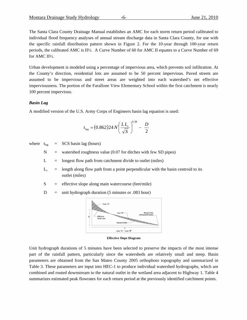
Effective Slope Diagram
Unit hydrograph durations of 5 minutes have been selected to preserve the impacts of the most intense part of the rainfall pattern, particularly since the watersheds are relatively small and steep. Basin parameters are obtained from the San Mateo County 2005 orthophoto topography and summarized in Table 3. These parameters are input into HEC-1 to produce individual watershed hydrographs, which are combined and routed downstream to the natural outlet in the wetland area adjacent to Highway 1. Table 4 summarizes estimated peak flowrates for each return period at the previously identified catchment points.

Montara Drainage Study Hydrology -7- June 21, 2010
Table 3 Hydrologic Parameters
Catchment Area
(acres)
L (mile)
Lc (mile)
S (feet/mile)
Basin Lag (hour)
Net Percent Impervious
1 81.46 0.55 0.33 323 0.23 54
2 20.49 0.35 0.11 394 0.11 52
3 9.43 0.27 0.13 416 0.09 55
Table 4 Estimated Peak Storm Runoff (cfs)
Catchment 10-year 25-year 50-year 100-year
1. East Ave / 2nd Street 58 74 86 99
2. Kanoff Ave from South 17 22 26 29
2. Kanoff Ave to West 68 88 102 116
3. 1st Street east of Hwy 1 72 92 108 123
Existing Storm Conveyance Facilities
Based on field surveys conducted by Creegan + D’Angelo, storm water runoff is conveyed from the indicated catchment points to the wetland/detention area adjacent to Highway 1 in a series of corrugated metal pipe (CMP) culverts, ditches and open swales. Table 5 lists these drainage facilities in series, provides flow capacity estimates, and identifies the controlling capacity for each segment in bold.
From Catchment Point 1 (CP1) to CP2, a 3 feet deep earthen ditch conveys runoff into a “flat area with no distinguishable toe or bank” adjacent to Second Street. This area is heavily overgrown with vegetation as shown in the photograph (to the right of the road), so a Manning’s channel roughness coefficient (n) of .08 is assumed; representing conditions of brush and trees in a floodplain. Higher ground to the north of the swale forces the natural release of floodwaters onto Second Street and adjacent low lying properties to the south. The driveway elevation at 360 Second Street is nearly one foot lower than the swale containment elevation.
Montara Drainage Study Hydrology -8- June 21, 2010
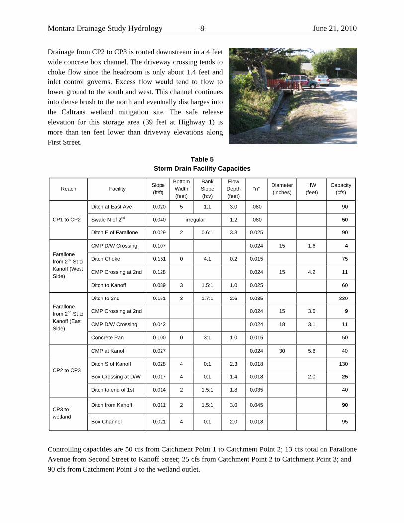
Drainage from CP2 to CP3 is routed downstream in a 4 feet wide concrete box channel. The driveway crossing tends to choke flow since the headroom is only about 1.4 feet and inlet control governs. Excess flow would tend to flow to lower ground to the south and west. This channel continues into dense brush to the north and eventually discharges into the Caltrans wetland mitigation site. The safe release elevation for this storage area (39 feet at Highway 1) is more than ten feet lower than driveway elevations along First Street.
Table 5 Storm Drain Facility Capacities
Reach Facility Slope (ft/ft)
Bottom Width (feet)
Bank Slope (h:v)
Flow Depth (feet)
“n” Diameter (inches)
HW (feet)
Capacity (cfs)
Ditch at East Ave 0.020 5 1:1 3.0 .080 90
Swale N of 2nd 0.040 irregular 1.2 .080 50 CP1 to CP2
Ditch E of Farallone 0.029 2 0.6:1 3.3 0.025 90
CMP D/W Crossing 0.107 0.024 15 1.6 4
Ditch Choke 0.151 0 4:1 0.2 0.015 75
CMP Crossing at 2nd 0.128 0.024 15 4.2 11
Farallone from 2nd St to Kanoff (West Side)
Ditch to Kanoff 0.089 3 1.5:1 1.0 0.025 60
Ditch to 2nd 0.151 3 1.7:1 2.6 0.035 330
CMP Crossing at 2nd 0.024 15 3.5 9
CMP D/W Crossing 0.042 0.024 18 3.1 11
Farallone from 2nd St to Kanoff (East Side)
Concrete Pan 0.100 0 3:1 1.0 0.015 50
CMP at Kanoff 0.027 0.024 30 5.6 40
Ditch S of Kanoff 0.028 4 0:1 2.3 0.018 130
Box Crossing at D/W 0.017 4 0:1 1.4 0.018 2.0 25 CP2 to CP3
Ditch to end of 1st 0.014 2 1.5:1 1.8 0.035 40
Ditch from Kanoff 0.011 2 1.5:1 3.0 0.045 90 CP3 to wetland
Box Channel 0.021 4 0:1 2.0 0.018 95
Controlling capacities are 50 cfs from Catchment Point 1 to Catchment Point 2; 13 cfs total on Farallone Avenue from Second Street to Kanoff Street; 25 cfs from Catchment Point 2 to Catchment Point 3; and 90 cfs from Catchment Point 3 to the wetland outlet.

Montara Drainage Study Hydrology -9- June 21, 2010
Storm Drain Remediation
Table 6 summarizes remediation required to provide sufficient drainage capacity for each of the return periods based on the capacity analysis described previously.
Table 6 Storm Drain Remediation
Capacity Deficit (cfs) Reach
Controlling Capacity
(cfs) 10-year 25-year 50-year 100-year
CP1 to CP2 50 8 24 36 49
Farallone to CP2 13 4 9 13 16
CP2 to CP3 25 43 63 77 91
CP3 to wetland 90 0 2 18 33
Three conceptual remediation alternatives are considered:
1. Improving the flow conveyance of existing drainage facilities.
2. Constructing a parallel underground conveyance system.
3. Storing excess water.
Alternative 1: Improving Existing Drainage Facilities
CP1 to CP2: Existing drainage facilities could be enlarged as required to pass the peak flows for a given return period. By clearing a swath of vegetation north of Second Street and constructing a clean channel with appropriate erosion control, the 100-year peak discharge (100 cfs) could be passed without flooding adjacent properties. Assuming the improved channel can be maintained with some weeds and light brush on the banks (Manning’s “n” of 0.045), a five- to ten-foot meandering channel bottom, and grade control structures limiting the longitudinal slope to about one percent (keeping flow velocities to less than five feet per second), the depth of channel required to carry the 100-year flow is about 2.5 feet. This option would require periodic maintenance to prevent the establishment of woody vegetation within the channel or banks.
Farallone to CP2: As evidenced by Table 5, the ditches running parallel to Farallone Avenue from Second Street to Kanoff Street have sufficient capacity; it is the undersized CMP crossings that choke the flow and cause storm runoff to spill onto private property. Kanoff Street is steep in this location (with a slope of 12 percent), so culvert hydraulics are inlet control; that is, the culvert capacity is controlled by the pipe diameter and inlet condition (headwall, projecting pipe, etc.).

Montara Drainage Study Hydrology -10- June 21, 2010
Existing CMP crossings could be upsized, with a commensurate increase in depth to accommodate the larger pipe. Assuming a minimum two feet of cover (the approximate amount of cover at most existing crossings), the size of necessary replacement culverts (without building headwalls) are summarized in Table 7.
CP2 to CP3: The existing culvert crossing at Kanoff Street north of Second Street is a 30 feet long, 30-inch diameter CMP culvert with concrete headwalls. Its full flow capacity is approximately 40 cfs under surcharged conditions with the adjacent ditch bank full. This capacity is less than the estimated 10-year peak runoff. Excess flow will inundate the driveway crossing to the north (toward the Kanoff Street right-of-way) and Second Street.
This culvert could also be replaced with a larger CMP or RCP culvert. It is assumed that the new culvert slope will remain the same as the existing pipe (0.026 ft/ft) and that 2.5 feet of minimum cover must be provided as is the case now. The necessary replacement pipe sizes (assuming a headwall) are summarized in Table 7.
Table 7 Replacement Culverts
Required CMP Culvert Size (inches) Required RCP Culvert Size (inches) Location
10-year 25-year 50-year 100-year 10-year 25-year 50-year 100-year
Farallone Avenue from 2nd Street to CP2
21 24 27 27 21 24 24 27
Kanoff Street north of 2nd Street (CP2)
48 48 54 60 42 48 48 54
CP3 to Wetland: Increasing capacity to accommodate the estimated 100-year flow at three feet of depth on a one percent slope requires roughly a five foot bottom width with 3:1 side slopes and light brush maintenance.
Alternative 2: Parallel Underground Conveyance System
For this alternative, storm drain pipe would be buried in the streets and paper streets from CP1 through to CP3, where the open ditch would still need to be improved to convey stormwater runoff to the wetland area and through the Highway 1 culvert to the ocean. The general route is from the intersection of East Avenue/Kanoff Street/Second Street, to the west on Second Street, north on Farallone Avenue to Kanoff Street, and west on Kanoff Avenue to the aforementioned discharge point (Figure 3).
Assuming pipe slopes that will maintain reasonable flow velocities (less than 10 feet per second), Table 8 summarizes a parallel RCP storm drain system that could accommodate the estimated peak flows, leaving the existing drainage facilities as a collection system.

Montara Drainage Study Hydrology -11- June 21, 2010
Figure 3: Parallel Storm Drain System
Table 8 Parallel Storm Drain Alternative
Required RCP Size (inches) Reach
10-year 25-year 50-year 100-year
2nd St from East Ave to Kanoff St at Farallone Ave 36 42 42 48
Kanoff St from 2 nd Street to Discharge Point 36 42 48 48
Montara Drainage Study Hydrology -12- June 21, 2010
Alternative 3: Storage of Excess Flow
Given right-of-way issues and the steep topography, surface storage is not considered particularly feasible. The potential for underground storage, perhaps with a commercially available product, is investigated herein. The concept is to limit peak runoff so that it can be accommodated by the existing drainage system. To better follow the topography and avoid excessive excavation, 3rd Street provides the best alignment for a buried storage system. Furthermore, by extending the storage system to the intersection of 3rd Street and Le Conte Avenue, not only can more storage be provided, but the area tributary to CP1 and its undersized downstream drainage system can be reduced, thereby also reducing the risk of flooding on 2nd Street. Since the drainage system in Kanoff Street north of 2nd Street is under capacity, discharge from the buried storage basin would be piped from 3rd Street to the Kanoff Street system. Figure 4 shows this conceptual alternative, including the reduction in watershed area tributary to CP1. The underground storage system would essentially cut off the watershed at 3rd Street. Table 9 lists hydrologic parameters (using the USACE basin lag equation described on Page 6) with underground storage and additional inlets along 3rd Street from Farallone Avenue to Le Conte Avenue.
Table 9 Hydrologic Parameters with Diversion at 3rd Street and Le Conte Avenue
Catchment Area
(acres)
L (mile)
Lc (mile)
S (feet/mile)
Basin Lag (hour)
Net Percent Impervious
1 17.80 0.38 0.21 312 0.14 52
2 8.35 0.17 0.06 237 0.05 52
3 9.43 0.27 0.13 416 0.09 55
Storage 75.80 0.67 0.32 236 0.24 54
Table 10 summarizes buried storage requirements to meet the 50 cfs capacity limitation between CP1 and CP2, the 25 cfs capacity limitation at the driveway crossing near the day care center on Kanoff Street between CP2 and CP3, and the 90 cfs capacity limitation downstream of CP3. Two sub-alternatives for storage are provided:
1. Dual circular pipe installed along 3rd Street (1,340 lineal feet available).
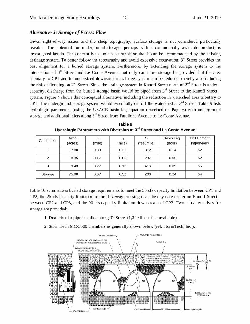
2. StormTech MC-3500 chambers as generally shown below (ref. StormTech, Inc.).

Montara Drainage Study Hydrology -13- June 21, 2010
Figure 4: Underground Storage
Each StormTech MC-3500 chamber holds 113 cubic feet when installed as diagrammed above. The chambers will need to be installed level, and the chambers may change in elevation as needed to accommodate the minor longitudinal slope of 3rd Street (2 percent). A maximum of three rows of installed chambers appears to be feasible within the existing street pavement sections, depending upon any underground utility conflicts. From Farallone Avenue to Le Conte Avenue, about 525 chambers could be reasonably installed. This equates to a total available volume of 60,500 cubic feet or 1.4 acre-feet. As indicated in Table 10, the lack of available storage under 3rd Street makes it infeasible to use anything other than dual storage pipes; and then only for the ten-year return period.
Montara Drainage Study Hydrology -14- June 21, 2010
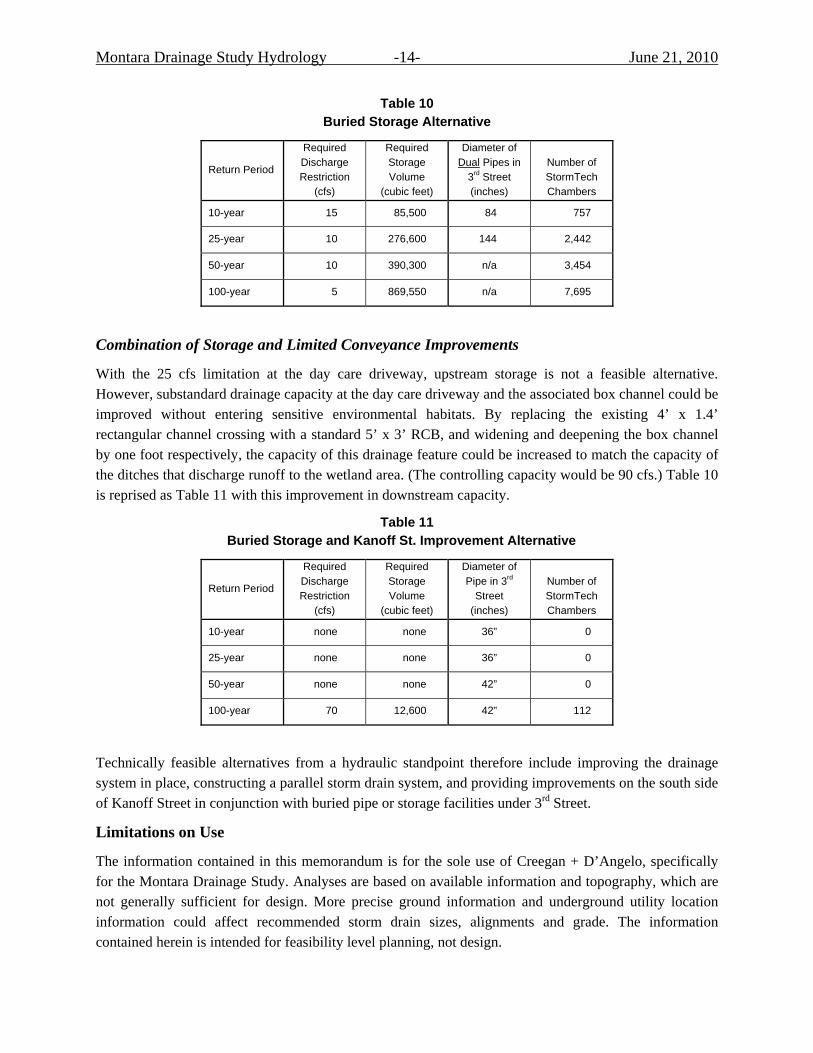
Table 10 Buried Storage Alternative
Return Period
Required Discharge Restriction
(cfs)
Required Storage Volume
(cubic feet)
Diameter of Dual Pipes in
3rd Street (inches)
Number of StormTech Chambers
10-year 15 85,500 84 757
25-year 10 276,600 144 2,442
50-year 10 390,300 n/a 3,454
100-year 5 869,550 n/a 7,695
Combination of Storage and Limited Conveyance Improvements
With the 25 cfs limitation at the day care driveway, upstream storage is not a feasible alternative. However, substandard drainage capacity at the day care driveway and the associated box channel could be improved without entering sensitive environmental habitats. By replacing the existing 4’ x 1.4’ rectangular channel crossing with a standard 5’ x 3’ RCB, and widening and deepening the box channel by one foot respectively, the capacity of this drainage feature could be increased to match the capacity of the ditches that discharge runoff to the wetland area. (The controlling capacity would be 90 cfs.) Table 10 is reprised as Table 11 with this improvement in downstream capacity.
Table 11 Buried Storage and Kanoff St. Improvement Alternative
Return Period
Required Discharge Restriction
(cfs)
Required Storage Volume
(cubic feet)
Diameter of Pipe in 3rd
Street (inches)
Number of StormTech Chambers
10-year none none 36” 0
25-year none none 36” 0
50-year none none 42” 0
100-year 70 12,600 42” 112
Technically feasible alternatives from a hydraulic standpoint therefore include improving the drainage system in place, constructing a parallel storm drain system, and providing improvements on the south side of Kanoff Street in conjunction with buried pipe or storage facilities under 3rd Street.
Limitations on Use
The information contained in this memorandum is for the sole use of Creegan + D’Angelo, specifically for the Montara Drainage Study. Analyses are based on available information and topography, which are not generally sufficient for design. More precise ground information and underground utility location information could affect recommended storm drain sizes, alignments and grade. The information contained herein is intended for feasibility level planning, not design.

Drainage Improvement Study for the 2nd Street, Kanoff Street and East Street Areas of Unincorporated Montara
County of San Mateo, California
February 7, 2011
Appendix D:
Technical Memorandum on Funding Strategies

870 Market Street, Suite 1223 | San Francisco, CA 94102 | Toll Free: 800.676.7516 | www.nbsgov.com
TECHNICAL MEMORANDUM
To: Meghan L. Cronin, PE, LEED AP, Senior Civil Engineer Creegan + D'Angelo Infrastructure Engineers
From: Jeanette Hahn, Director of Financial Consulting NBS
Date: November 8, 2010
Re: Summary of Funding Strategies County of San Mateo – Montara Drainage Improvement Study
INTRODUCTION
The purpose of this memorandum is to summarize considerations and strategies in funding proposed local drainage improvements in unincorporated Montara in San Mateo County. Information provided includes:
• Net present value analysis of each improvement solution.
• Summary of locally‐controlled revenue sources for initial capital improvement expenditures and ongoing maintenance and replacement reserve funding.
Four viable improvement solutions are presente d in the Creegan + D’Angelo feasibility study:
• Alternative 1: Improving existing drainage facilities
• Alternative 2: Constructing a parallel underground conveyance system
• Alternative 3: Storing excess water
• Alternative 4: C ombination of storage and limited conveyance improvements
The feasibility study has prepared cost estimates for each improvement solution under two conditions: 10‐ and 25‐year storm remediation. Estimates include initial installation costs of design, permitting, mobilization, and construction management. Additionally, estimates have been prepared describing annual maintenance costs and annual reserve funding for future rehabilitation and replacement of improvements. Estimates do not include costs of right‐of‐way acquisition or possible environmental permitting fees.

Summary of Funding Strategies – County of San Mateo Montara Drainage Improvement Study Page 2 Submitted by NBS – November 8, 2010
NET PRESENT VALUE ANALYSIS
Net present value (NPV) analysis is a method for comparing the economic feasibility of alternative solutions, taking into account the time value of money. To express the cost of each solution comparatively in present value, NPV analysis requires the selection of a key assumption in the discount rate applicable to future cash flows. In the municipal setting, the cost of capital is a commonly utilized assumption, with no further adjustment for risk or alternative investment (for profit) common in private sector analysis. Cost of capital is most readily linked to prevailing interest rates associated with municipal bonds. In this case, a rate of 5.0% has been used. A time period of 50 years has been selected for the comparative analysis, with each improvement solution set for whole replacement once every 30 years. Replacement has been presumed to be entirely cash‐funded; therefore, the necessary recurrent replacement reserve funding to support that approach has been recalibrated in this analysis from the value assigned in the feasibility analysis. Additional assumptions include construction cost inflation at 4.0% annually, general cost inflation at 3.0% annually, and invested earnings at 2.0% annually.
Exhibits 1 through 4 summarize the simple cash flows for each of the four improvement solutions, inclusive of initial installation, annual maintenance, and annual reserve funding for capital replacement. Expressed in projected future values, these tables represent the total burden to County resources of the improvement solution in the year listed. These values may be directly compared in magnitude to existing, potential fund/departmental/divisional budgets within the County’s financial/organizational structure that might be tapped as the one‐time funding source for the initial capital outlay and/or the recurring, annual funding source for subsequent maintenance costs and replacement reserves.
Exhibit 1. Simple Cash Flow, Improvement Solution Alternative 1
10‐YEAR REMEDIATION SOLUTIONYear 1 10 20 30 40 50Initial Capital Outlay 107,001$ ‐$ ‐$ ‐$ ‐$ ‐$ Annual Maintenance Cost 4,500 5,871 7,891 10,605 14,252 19,153 Annual Reserve Contribution 8,226 8,226 8,226 8,226 26,679 26,679
Total Cash Obligation 119,727 14,097 16,116 18,830 40,931 45,832
25‐YEAR REMEDIATION SOLUTIONYear 1 10 20 30 40 50Initial Capital Outlay 116,505$ ‐$ ‐$ ‐$ ‐$ ‐$ Annual Maintenance Cost 4,500 5,871 7,891 10,605 14,252 19,153 Annual Reserve Contribution 8,956 8,956 8,956 8,956 29,049 29,049
Total Cash Obligation 129,961 14,828 16,847 19,561 43,300 48,202
Summary of Funding Strategies – County of San Mateo Montara Drainage Improvement Study Page 3 Submitted by NBS – November 8, 2010
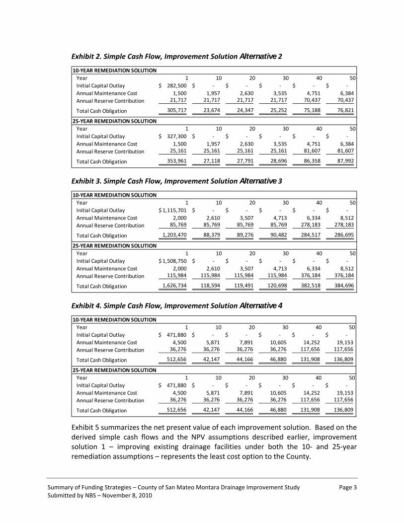
Exhibit 2. Simple Cash Flow, Improvement Solution Alternative 2
10‐YEAR REMEDIATION SOLUTIONYear 1 10 20 30 40 50Initial Capital Outlay 282,500$ ‐$ ‐$ ‐$ ‐$ ‐$ Annual Maintenance Cost 1,500 1,957 2,630 3,535 4,751 6,384 Annual Reserve Contribution 21,717 21,717 21,717 21,717 70,437 70,437
Total Cash Obligation 305,717 23,674 24,347 25,252 75,188 76,821
25‐YEAR REMEDIATION SOLUTIONYear 1 10 20 30 40 50Initial Capital Outlay 327,300$ ‐$ ‐$ ‐$ ‐$ ‐$ Annual Maintenance Cost 1,500 1,957 2,630 3,535 4,751 6,384 Annual Reserve Contribution 25,161 25,161 25,161 25,161 81,607 81,607
Total Cash Obligation 353,961 27,118 27,791 28,696 86,358 87,992
Exhibit 3. Simple Cash Flow, Improvement Solution Alternative 3
10‐YEAR REMEDIATION SOLUTIONYear 1 10 20 30 40 50Initial Capital Outlay 1,115,701$ ‐$ ‐$ ‐$ ‐$ ‐$ Annual Maintenance Cost 2,000 2,610 3,507 4,713 6,334 8,512 Annual Reserve Contribution 85,769 85,769 85,769 85,769 278,183 278,183
Total Cash Obligation 1,203,470 88,379 89,276 90,482 284,517 286,695
25‐YEAR REMEDIATION SOLUTIONYear 1 10 20 30 40 50Initial Capital Outlay 1,508,750$ ‐$ ‐$ ‐$ ‐$ ‐$ Annual Maintenance Cost 2,000 2,610 3,507 4,713 6,334 8,512 Annual Reserve Contribution 115,984 115,984 115,984 115,984 376,184 376,184
Total Cash Obligation 1,626,734 118,594 119,491 120,698 382,518 384,696
Exhibit 4. Simple Cash Flow, Improvement Solution Alternative 4
10‐YEAR REMEDIATION SOLUTIONYear 1 10 20 30 40 50Initial Capital Outlay 471,880$ ‐$ ‐$ ‐$ ‐$ ‐$ Annual Maintenance Cost 4,500 5,871 7,891 10,605 14,252 19,153 Annual Reserve Contribution 36,276 36,276 36,276 36,276 117,656 117,656
Total Cash Obligation 512,656 42,147 44,166 46,880 131,908 136,809
25‐YEAR REMEDIATION SOLUTIONYear 1 10 20 30 40 50Initial Capital Outlay 471,880$ ‐$ ‐$ ‐$ ‐$ ‐$ Annual Maintenance Cost 4,500 5,871 7,891 10,605 14,252 19,153 Annual Reserve Contribution 36,276 36,276 36,276 36,276 117,656 117,656
Total Cash Obligation 512,656 42,147 44,166 46,880 131,908 136,809
Exhibit 5 summarizes the net present value of each improvement solution. Based on the derived simple cash flows and the NPV assumptions described earlier, improvement solution 1 – improving existing drainage facilities under both the 10‐ and 25‐year remediation assumptions – represents the least cost option to the County.

Summary of Funding Strategies – County of San Mateo Montara Drainage Improvement Study Page 4 Submitted by NBS – November 8, 2010
Exhibit 5. Net Present Value of Improvement Solutions
Improvement Solution 50‐Yr NPV
Alt. 1, 10‐Year Remediation 444,267$
Alt. 1, 25‐Year Remediation 471,382$
Alt. 2, 10‐Year Remediation 852,323$
Alt. 2, 25‐Year Remediation 980,141$
Alt. 4, 10 -Yea r R eme dia tion $ 1,485,296
Alt. 4, 25-Year Remediation $ 1,485,296
Alt. 3, 10‐Year Remediation 3,244,956$
Alt. 3, 25‐Year Remediation 4,366,356$
It is important to note that comparative NPV outcomes for each solution are impacted materially by the timing and frequency of future capital replacement outlays. This analysis has presumed uniform timing/frequency of replacement between each project; however, if higher cost improvement solutions yield longer useful lives, the NPV of an apparently higher cost solution might actually be closer or lower than an apparently lower cost solution.
LOCAL FUNDING MECHANISMS
To fund the cash obligations summarized in the preceding section (Exhibits 1 through 4), the County will need to acquire a one‐time revenue source for the initial capital cost of installing its selected improvement solution, as well as a recurring, annual revenue source for maintenance and capital replacement reserve funding.
Upon internal evaluation of the simple cash flows listed in Exhibits 1 though 4, the County may determine that the costs of its chosen improvement solution can be scheduled and budgeted reasonably within the programmatic objectives and capabilities of an existing fund in its current financial/organizational structure. When compared to the magnitude of the County’s existing capital improvement and maintenance budgets for select departments/funds where drainage improvements potentially could be programmed, the total outlays – particularly in the least cost options – are not out of line with currently scheduled projects and recurring obligations. While those funds may be wholly appropriated at present, it may be that internal County prioritization of projects would view the Montara drainage improvement of higher urgency than other projects, thus freeing an existing revenue stream.
If appropriation of existing revenues is not possible, the County must either acquire a wholly external funding source, such as a loan or grant from another agency, or seek approval for a new tax, assessment, or fee on property owners. The following sections
Summary of Funding Strategies – County of San Mateo Montara Drainage Improvement Study Page 5 Submitted by NBS – November 8, 2010
discuss potential land‐secured or property‐based mechanisms, all of which require some degree of voter‐ or property‐owner approval and would generate ongoing administrative efforts and costs to maintain. These formation, approval thresholds, and ongoing efforts should be weighed against the ease (or lack thereof) of programming the County’s selected drainage improvement solution within existing departmental/fund budgets, particularly in the least cost options. Pursuit of these funding sources not only requires rigorous analytical justification: it also requires upfront knowledge of political will and feasibility of garnering community support.
Community Facilities District
A Community Facilities District (CFD) can be formed pursuant to the Mello‐Roos Community Facilities Act of 1982. A CFD can pay for both capital projects as well as ongoing maintenance. Bonds would be issued to pay for capital costs secured by a special tax levy. (Depending on the selected drainage improvement solution, a small initial capital cost likely may make a bond issue non‐viable, and another revenue would need to be acquired.) The same CFD can also fund ongoing maintenance cost through a special tax levy.
There is great flexibility in both the geographic area to be levied and the formula by which to levy when using a CFD. A CFD may include non‐contiguous geographic areas. There is no requirement that the special tax be apportioned on the basis of benefit to any property. Property owned by a public entity is generally exempt from the CFD special tax, ensuring no lingering obligation of other County revenues.
Successful creation of a CFD requires approval of two‐thirds of the registered voters voting in an election (or approval of the landowners if less than 12 persons are registered to vote within the CFD boundary). With a voter election, each voter has one vote, regardless of their weighted share of the proposed special tax levy. In a landowner election, the vote is one vote per acre or portion thereof.
1913/1915 Act Assessment District
A 1913/1915 Act Assessment District can be formed pursuant to the Municipal Improvement Act of 1913, and bonds would be issued pursuant to the Improvement Bond Act of 1915. (Depending on the selected drainage improvement solution, a small initial capital cost likely may make a bond issue non‐viable, and another revenue would need to be acquired.) This type of funding mechanism can only pay for capital outlays, not maintenance costs.
As an assessment district, there is a higher standard of benefit assignment, and the formula distributing costs must be detailed and substantiated with a report prepared by a Professional Engineer. The proportionate special benefit received by each parcel must be determined in relationship to the entirely of the capital cost of the public improvement. Parcels within the boundary that are owned by a public entity are not
Summary of Funding Strategies – County of San Mateo Montara Drainage Improvement Study Page 6 Submitted by NBS – November 8, 2010
exempt from assessment unless the County can show by “clear and convincing evidence” that the properties in fact receive no special benefit. For drainage projects impacted greatly by storm run‐off from public roadways, this is virtually impossible; therefore, this funding mechanism would yield a remaining obligation to be met by other County revenues.
Notices and ballots are mailed to the affected property owners. When tabulating, the ballots are weighted according to the proportional financial obligation of the affected property. If the ballots submitted in opposition to the assessment do not exceed the ballots submitted in favor, the assessment district may be formed.
Benefit Assessment District
A Benefit Assessment District (BAD) can be formed pursuant to the Benefit Assessment Act of 1982. A BAD can fund ongoing maintenance costs but cannot fund capital costs.
As an assessment district, there is a higher standard of benefit assignment, and the formula distributing costs must be detailed and substantiated with a report prepared by a Professional Engineer. The proportionate special benefit received by each parcel must be determined in relationship to the entirely of the capital cost of the public improvement. Parcels within the boundary that are owned by a public entity are not exempt from assessment unless the County can show by “clear and convincing evidence” that the properties in fact receive no special benefit.
Notices and ballots are mailed to the affected property owners. When tabulating, the ballots are weighted according to the proportional financial obligation of the affected property. If the ballots submitted in opposition to the assessment do not exceed the ballots submitted in favor, the assessment district may be formed.
Property‐Related Fee
A property‐related fee is a fee for service attributable to the parcel being charged. A fee for storm drainage services levied upon the County tax roll is considered to be imposed as an incident of property ownership and as such, would be subject to the substantive and procedural requirements of California Constitution Article XIII D (known commonly by its enacting ballot measure: Proposition 218). The fee must be submitted and approved by a majority vote of the property owners or by a two‐thirds vote of the electorate. The amount charged to each parcel must be proportional to the cost of service attributable to that parcel.
For a property owner election, each parcel generally receives one ballot, and each ballot has one vote regardless of the potential levy amount, although the County may also have the power to provide for weighted voting. In one‐parcel‐per‐vote elections, a large commercial parcel with a calculated levy that is orders of magnitude greater than that of a vacant parcel would have the same, single vote as the vacant parcel.

Summary of Funding Strategies – County of San Mateo Montara Drainage Improvement Study Page 7 Submitted by NBS – November 8, 2010
The revenue stream from a property‐related fee may be used for both capital and maintenance costs. The revenue stream could be pledged for a revenue bond issue to fund major capital improvements. (Again, the least cost improvement solution may have initial capital costs too low for a viable bond issuance; however, an interfund loan or other loan repayment could be supported by the resultant revenues.)
Impact Fees
Finally, while existing conditions in the Montara area demonstrate a drainage system undersized to prevent current flooding events, the feasibility study noted that such conditions will be exacerbated by and future issues could arise as a result of future development in the area. Furthermore, most currently developed lots are not yet developed to maximum impermeable surface allowed by County code, which means redevelopment will also contribute to burden on existing facilities and a need for future, upsized facilities. These described conditions provide an opportunity for the imposition of a development impact fee in the Montara area.
A development impact fee is a one‐time fee imposed as a condition of development approval on new development that creates new, unmitigated impermeable surface and redevelopment that increases without mitigation impermeable surface. Development impact fees are authorized by Government Code 66000 et seq., created by the Mitigation Fee Act and referred to commonly as “AB 1600” fees.
A development impact fee may be established applicable to the Montara area based on that portion of the capital costs necessary to serve the burdens of new impermeable surface. (Based on the existing deficiencies, the fee cannot cover the entirety of the costs, leaving obligations that must be met through another revenue source.) If capital costs were funded by another revenue source prior to development and corresponding receipt of the impact fee, fee revenues may be used to replenish or pay back that prior revenue source. Impact fees may not recover any maintenance costs.
Impact fees may be implemented by consensus of the County Board of Supervisors alone. A nexus analysis and fee justification report must be prepared and made available to the public in advance of the public hearing.
USE OF REPORTING
The preceding information has been issued to Creegan + D’Angelo as a part of its feasibility reporting for the referenced project. Outcomes presented may be impacted materially by refinement of the assumptions described. Furthermore, funding mechanisms are presented at a summary level and require methodical action plans to implement. Please contact NBS with any questions or further discussion.