6.12 minmi
TRANSCRIPT
Newcastle Development Control Plan 2012 6.12 Minmi 1
6.12 Minmi
Amendment history
Version Number
Date Adopted by Council
Commencement Date
Amendment Type
1 15/11/2011 15/06/2012 New
Savings provisions
Any development application lodged but not determined prior to this section coming into effect will be determined taking into consideration the provisions of this section.
Land to which this section applies
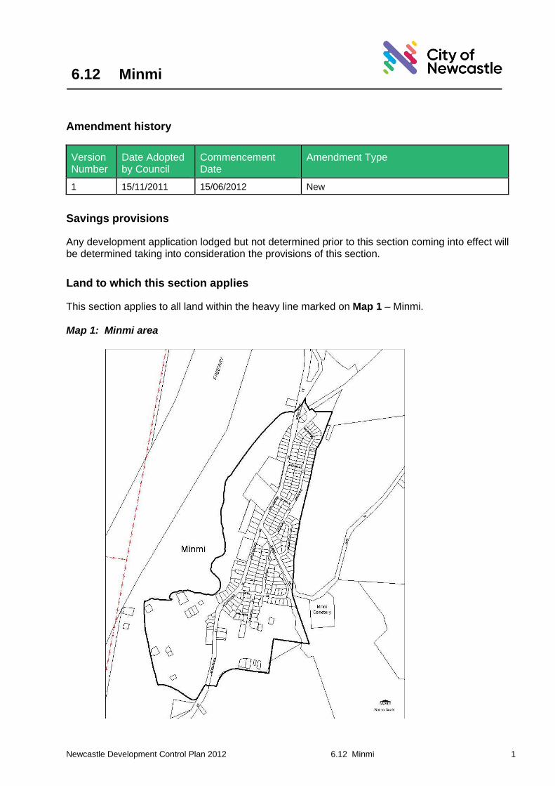
This section applies to all land within the heavy line marked on Map 1 – Minmi.
Map 1: Minmi area

Newcastle Development Control Plan 2012 6.12 Minmi 2
Development (type/s) to which this section applies
This section applies to all development within Minmi requiring development consent.
Applicable environmental planning instruments
The provisions of the Newcastle Local Environmental Plan 2012 also applies to development applications to which this section applies.
In the event of any inconsistency between this section and the above listed environmental planning instrument, the environmental planning instrument will prevail to the extent of the inconsistency.
Note 1: Additional environmental planning instruments may also apply in addition to those listed above.
Note 2: The Environmental Planning and Assessment Act 1979 enables an environmental planning instrument to exclude or modify the application of this DCP in whole or part.
Related sections
The following sections of this DCP will also apply to development to which this section applies: ▪ Any applicable land use specific provision under Part 3.00
Note: Any inconsistency between the locality specific provision and a land use specific provision, the locality specific provision will prevail to the extent of the inconsistency.
▪ 7.03 Traffic, Parking and Access ▪ 7.05 Energy Efficiency ▪ 7.06 Stormwater ▪ 7.07 Water Efficiency ▪ 7.08 Waste Management.
The following sections of this DCP may also apply to development to which this section applies: ▪ 4.01 Flood Management – all land which is identified as flood prone land under the
Newcastle Flood Policy or within a PMF or area likely to flood ▪ 4.02 Bush Fire Protection – within mapped bushfire area/zone ▪ 4.03 Mine Subsidence – within mine subsidence area ▪ 4.04 Safety and Security – development with - accessibility to general public, access to
laneways, communal areas, or residential with three or more dwellings ▪ 4.05 Social Impact – where required under ‘Social Impact Assessment Policy for
Development Applications’, 1999 ▪ 5.01 Soil Management – works resulting in any disturbance of soil and/or cut and fill ▪ 5.02 Land Contamination – land on register/where risk from previous use ▪ 5.03 Vegetation Management – trees within 5m of a development footprint or those trees
likely to be affected by a development ▪ 5.04 Aboriginal Heritage – known/likely Aboriginal heritage item/site and/or potential soil
disturbance ▪ 5.05 Heritage Items – known heritage item or in proximity to a heritage item ▪ 5.06 Archaeological Management – known/likely archaeological site or potential soil
disturbance ▪ 7.04 Movement Networks – where new roads, pedestrian or cycle paths are required
Newcastle Development Control Plan 2012 6.12 Minmi 3
Associated technical manual/s ▪ Nil
Additional information ▪ Minmi: The Place of the Giant Lily (Newcastle and Hunter District Historical Society Inc,
1991) ▪ Flora Report: Bonnie Doon Estate, Minmi, Newcastle (Rodd and Clements, 1995) ▪ Minmi Conservation Study (Shellshear, 1990) ▪ Fauna Survey Bonnie Doon Estate, Minmi NSW Lot 23 DP 806397 and Part Lot 33 DP
800036 (Lim and White, 1995) ▪ Minmi Review of Environmental Effects (GW Hawke and Associates Pty Ltd 1990)
Definitions
A word or expression used in this development control plan has the same meaning as it has in Newcastle Local Environmental Plan 2012, unless it is otherwise defined in this development control plan.
Other words and expressions referred to within this section are defined within Part 9.00 - Glossary of this plan.
Aims of this section
1. To ensure that Minmi retains its existing village character, whilst accommodating limited urban and rural residential growth.
2. To develop as the westernmost local activity centre for Blue Gum Hills.
3. To ensure that the built heritage and character of Minmi is preserved through landscape separation.
4. To contribute to tourist related development and strengthen the local employment base.
5. To manage nutrient or stormwater flow rates to ensure the health of Minmi Creek and other waterways.
6. To conserve reasonably undisturbed bushland.
6.12.01 Urban structure
A. Land use
Objectives
1. Ensure community facilities and services such as shops, community centre/hall and child care facilities are located in an accessible, central location within the village and foster community interaction.
2. Ensure future development builds upon the current clustering of facilities at the centre of the village and relates to the surrounding parkland.
Newcastle Development Control Plan 2012 6.12 Minmi 4
3. Ensure urban areas are appropriately located.
Controls
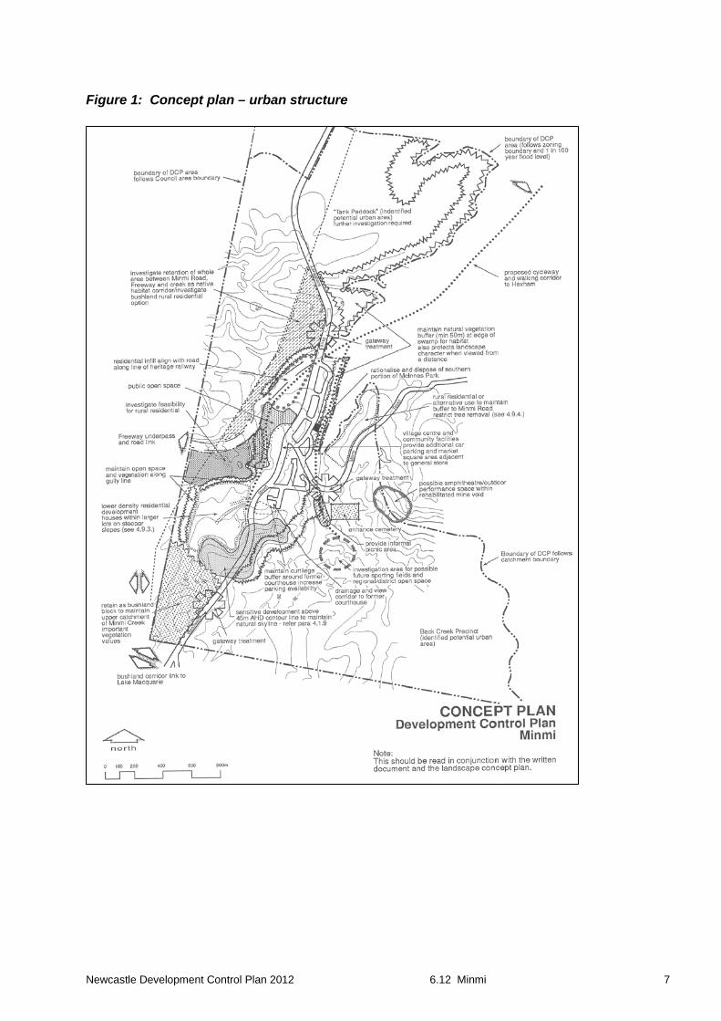
1. The community centre, community facilities and preferred location for business activities are shown marked on the concept plan at Figure 1.
2. Compatible mixed use development is encouraged throughout the village, with more intensive uses located in the village centre. In particular, art and craft related activities are encouraged.
3. Detailed study and assessment of identified potential urban areas shall be carried out before any decision is made as to their suitability for urban purposes.
B. Open space
Objectives
1. Ensure development within the village creates a place with a distinct identity and which is physically separated from other urban areas.
2. Ensure open space is integrated with community uses and access.
Controls
1. Development to comply with Section 7.02 Landscaping, Open Space and Visual Amenity.
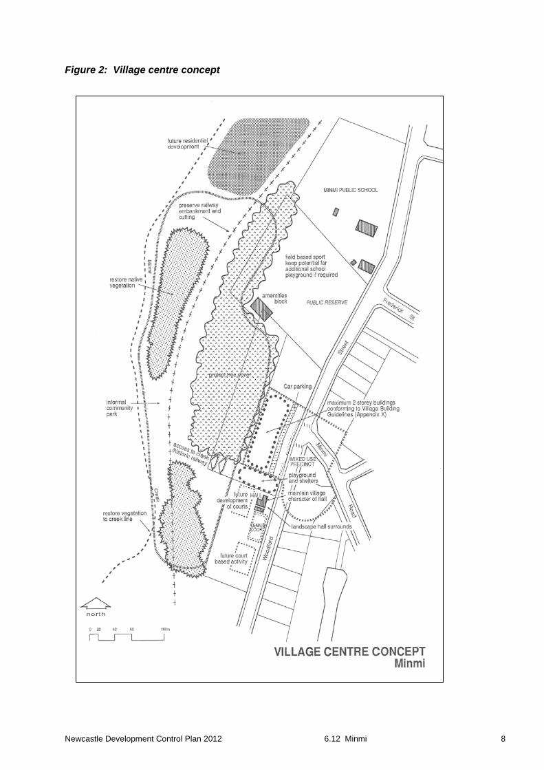
2. Open space shall be provided within the village and shall be integrated with community uses and access, generally as indicated on the concept plan at Figures 1 and 2.
3. Open space adjacent to the east of the village will be integrated with the Summerhill Master Plan.
4. Landscape design reinforces the identity of Minmi as a distinct village area separated from other residential development, by establishing and reinforcing landscape features and developing suitable planting themes based on research in the area.
5. Open space and drainage corridors are designed for low maintenance bushland regeneration, unless the area is designated for active recreation or this treatment is inappropriate for other reasons.
C. Water
Objectives
1. Ensure water quality is maintained.
Controls
1. Development to comply with Section 7.06 Stormwater
2. Riparian vegetation should be restored along major creeks and waterways.
Newcastle Development Control Plan 2012 6.12 Minmi 5
D. Biological diversity
Objectives
1. Encourage biological diversity.
Controls
1. Revegetation restores the diversity of indigenous species originally present on the site which may have been lost.
2. New development should not adversely affect (and should preferably benefit) the downstream Hexham Wetlands which is recognised as being of international significance as habitat for migratory birds.
3. Bushland is to be retained wherever possible. A diversity of bushland types should be retained or restored.
E. Urban design and heritage
Objectives
1. Ensure appropriate bulk and scale of development to protect the character of the area.
2. Ensure important views and vistas are retained and enhanced.
Controls
1. Refer to the Newcastle Local Environmental Plan 2012 for height and floor space ratio controls. In general no building shall exceed two storeys in height, in keeping with the existing character of the area.
2. Vistas to rolling hills and distant rural and natural landscapes are to be retained to maintain village context and identity.
3. A treed ridgeline should be maintained and enhanced on the prominent ridge/hill at the south of the village boundary.
4. Any additional buildings should be designed and sited to maintain the treed ridgeline and prevent the dominance of built form.
5. Additional tree planting to revegetate the ridgeline should be undertaken, where appropriate.
6. Subdivision or development within the vicinity of the former Court House/Police Station is to provide right of vehicular and pedestrian access to that site.
F. Archaeology
Objectives
1. To ensure archaeology matters are considered.
Newcastle Development Control Plan 2012 6.12 Minmi 6
Controls
1. Development to comply with Section 5.04 Aboriginal Heritage and Section 5.06 Archaeological Management.
2. Where significant land disturbance is proposed, investigation of impacts on both Aboriginal and European heritage will be required and field investigations or excavation may be necessary.
G. Stormwater management
The majority of the area drains into Minmi Creek, which subsequently flows into the Hexham Wetlands. Minmi Creek receives runoff from Minmi Village as well as from grazing and forested land. A significant 1-2km vegetated buffer separates Minmi Creek from the boundary of the SEPP14 (State significant) wetlands. The buffer comprises a heavily vegetated waterway, and a floodplain covered in grasses and sedges that are grazed by cattle. Instream modification and treatment of stormwater and floodwater flows is likely to occur before such water reaches the SEPP14 wetlands. Consequently, less stringent controls can be applied to stormwater discharges than for other areas which discharge directly into the SEPP14 wetlands.
Objectives
1. Ensure stormwater is appropriately managed in accordance with Council requirements.
Controls
1. Development to comply with Section 7.06 Stormwater.
2. Drainage channels are to be retained as far as possible in a natural condition. Vegetation corridors are to be maintained or regenerated along creeks.
3. Discharges should be managed to ensure no excessive export of sediments.
4. Nutrients or stormwater flow rates are to be managed to ensure the health of Minmi Creek and other waterways.
H. Access
Objectives
1. Ensure development incorporates adequate access networks.
Controls
1. Development to comply with Section 7.04 Movement Networks – where new roads, pedestrian or cycle paths are required.
2. The principles of walkability, connectivity, permeability, legibility and safety shall apply to all subdivision and access system design.
Newcastle Development Control Plan 2012 6.12 Minmi 7
Figure 1: Concept plan – urban structure
Newcastle Development Control Plan 2012 6.12 Minmi 8
Figure 2: Village centre concept
Newcastle Development Control Plan 2012 6.12 Minmi 9
6.12.02 Landscape design
A. Protection of bushland
Objectives
1. Ensure important areas of existing bushland are retained.
Controls
1. Development to comply with Section 7.02 Landscaping, Open Space and Visual Amenity.
2. Corridors of natural bushland are retained along main roads at the approaches to the village (minimum width of 50-100 metres) as identified on the landscape concept plan.
3. Other areas of bushland may be required for the purpose of maintaining fauna habitat and wildlife corridors or to provide visual buffers, including the Back Creek system to the east of the village which provides links to Summerhill.
4. Bushland is maintained in contiguous blocks.
5. Previously degraded and eroded land within the Minmi area should be rehabilitated with appropriate revegetation.
B. Gateway
Objectives
1. Establish a gateway to the village.
Controls
1. Use feature planting, signage and controlled views, to create a sense of arrival and to delineate the unique character and to reinforce the distinctiveness of the village to other urban development and surrounding bushland.
C. Landscaping in vicinity of heritage items
Objectives
1. Ensure appropriate landscaping in the context of heritage items.
Controls
1. Existing bushland around the cemetery is to be retained and extended where possible to retain a minimum width of 50-100m of vegetation to the northern, southern and eastern side boundaries of the cemetery. This is to screen views to and from the cemetery and residential areas to protect the scenic quality of the cemetery.
2. A conservation study will determine the landscaping improvements within and at close proximity to the cemetery.
Newcastle Development Control Plan 2012 6.12 Minmi 10
3. Views to identified heritage items are maintained where possible. However, screen planting may be introduced where necessary to prevent inappropriate views to and from incompatible land uses which may detract from the sense of place or to control views to enhance the heritage aspects of a place.
D. Traffic control
Objectives
1. Facilitate traffic safety.
Controls
1. As the area develops, it may be necessary to introduce traffic control devices within the village to promote safety, restrict fast moving traffic and enhance village character.
E. Biological diversity
Objectives
1. Support habitat in and around Minmi for native flora and fauna.
Controls
1. As far as possible corridor linkages are maintained to other areas of remnant native vegetation within Newcastle city, and the adjoining local government areas of Cessnock and Lake Macquarie.
2. Where possible remnants are preserved to ensure access for future management by providing adequate area/perimeter ratios so long narrow strips and isolated parcels are avoided.
3. Native habitat is to be maintained and/or regenerated along major drainage lines such as Minmi Creek with a minimum width of vegetation of at least 50m from either side of the creek banks. The final width is to be determined by site considerations.
4. Bushland corridor linkages have a minimum width of 100m and enable self sustaining ecosystems to be maintained on the land as far as possible.
5. Regeneration of trees should be undertaken along wetland fringes to provide fauna habitat. Within bushland areas, there should be retention and enhancement of fauna habitat (including retaining dead trees, fallen logs, leaf litter, etc).
Newcastle Development Control Plan 2012 6.12 Minmi 11
F. Contaminated land and land stability
Objectives
1. Support habitat in and around Minmi for native flora and fauna.
Controls
1. Development to comply with Section 5.02 Land Contamination.
2. Measures are taken to assess the nature of any contamination or effect and take remedial action where necessary, having particular regard for past mining and filling activities that have occurred in the area.

Newcastle Development Control Plan 2012 6.12 Minmi 12
This page is intentionally blank.