7.0 non-aboriginal context - home - roads and maritime ... · wollstonecraft obtained a grant and...
TRANSCRIPT

Cultural Heritage Assessment – Gerringong upgrade Page 57
77.0 Non-Aboriginal context
7.1 Historical overview
The proposal study area lies within the administrative boundaries of the Kiama Municipality - a jurisdiction determined in the recent past on 11 June 1954. This area originated from the aggregation of smaller town and village-based municipalities, which in turn began as a result of European pastoral activities centred on a number of sizeable land grants in the region as early as the 1820s. By 1850, Alexander Berry had consolidated his estate, which extended close to the southern and western limits of Gerringong. Before the 1820s, except for a few intrepid cedar cutters, the district was mostly unknown to Europeans.
7.1.1 Early exploration
In April 1770, Captain James Cook was the first European to sight the eastern shores of the region while sailing north towards Botany Bay. Cook named Pigeon House Mountain, Cape St George and noted the entrance of what seemed to be a bay (Jervis Bay), the inner north head of which he named Longnose Point, before passing Kiama’s shore and on to further exploration. Nothing more of the area was recorded until after the settlement of Sydney in 1788. On 27 July 1791, Captain Weatherhead of the Matilda discovered Jervis Bay, which he named Matilda Bay after his ship, but the name was not retained. Following his visit to the bay on 18 August 1791, Naval Lieutenant Bowen provided the name ‘Port Jervis’ in honour of Sir John Jervis. Whaling ships immediately began calling there for shelter and water. The district was first crossed overland by Europeans when Clarke and the remaining surviving sailors of the Sydney Cove, which was wrecked in Bass Strait and again at Point Hicks in May 1797, passed through it in April of that year. Later in 1797, The Cumberland was wrecked south of Jervis Bay in 1979 and the survivors also made their way overland to Sydney. In December 1797, George Bass, during his voyage of coastal exploration in a whaleboat with a crew of six seamen, landed in a sheltered bay, later named Kiama Harbour, and followed around the bight of Seven Mile Beach to discover the mouth of a river, which he named Shoals Haven. He spent three days examining the river, noting the fertile banks that he thought would not be subject to flooding (Bayley 1975: 15-16, 1976: 15). Knowledge of the area was advanced when on 10 March 1805 Lieutenant Kent of HMS Buffalo returned to Sydney after examining the district overland 18 miles north from Jervis Bay with James Meehan, the assistant Surveyor General. Information from that expedition confirmed that the area was originally covered with rainforest, brush cedar, soft and hardwoods and a variety of bushes, palms, vines and ferns. Independent cedar getters were in the Shoalhaven from at least 1811. After grounding on the shoals, the Speedwell managed to bring the first recorded cargo of cedar from the Shoalhaven River to Sydney in December 1812. The timber industry then grew in scale, exploiting the patches of cedar on the rivers and creeks, but the main concentration was in the Long Brush, which stretched from Kiama to Jamberoo (Freeman 1998:11). A cedar party comprising George Wood, Jones and Dawson was lost in early 1815 and a search located one body, said to be that of Wood, all having been killed by Aborigines. Following that episode, Governor Macquarie forbade the cedar cutters from visiting the district.

Cultural Heritage Assessment – Gerringong upgrade Page 58
Exploration from landward began in February 1818 when Dr Charles Throsby and James Meehan set out from Sydney to find an overland route to Jervis Bay. The party reached Kangaroo Valley, crossed the Shoalhaven and reached Jervis Bay but found the route to be impractical. To find a better route in 1819, two surveyors, John Oxley and James Meehan, explored Jervis Bay, Currambene Creek and the site of Nowra. From there Meehan went due north; however, that inland section did not offer a feasible route for wheeled vehicles. The need for a better route from the Southern Highlands was met, to an extent, in 1821 by a new route pioneered by Hamilton Hume and Charles Throsby through Tallaganda Shire, which Hume reported could be made along a line of where he marked the trees. However, the route was not developed until the 1840s when The Wool Road from Braidwood via Nerriga, Sassafras and Wandandian was created. No sooner had Hume returned from that expedition when, in January 1822, he left Sydney in the Snapper with Lieutenant Johnston and Alexander Berry to explore the coastal rivers, sailing up the Clyde and trudging inland to the Pigeon House. Although it was a government sponsored voyage it appears that Berry’s purpose was to seek out land on which he could make a settlement after an adventurous life of roving in his early days (Bayley 1975: 20).
77.1.2 Nineteenth-century estates in the study area
The Berry Estate
After a brief stay in Sydney in 1808 during his early career as an international merchant, Alexander Berry returned to London in 1812 by way of Cadiz. In Cadiz, Berry met Edward Wollstonecraft, who subsequently became Berry's London agent, and later his partner when they decided to start a business in Sydney. Berry returned to Sydney in July 1819 and Wollstonecraft arrived in September. While Wollstonecraft supervised their George Street business, Berry visited England in March 1820, carrying Governor Macquarie’s dispatches, one of which described him as 'an eminent merchant of this place'. In 1827, Berry married Wollstonecraft's sister Elizabeth. Like other merchants Berry and Wollstonecraft often had to accept stock in payment of debts and Berry sought a grant of land on which to accommodate the stock. Macquarie refused, as Berry was about to leave for England, but promised him a grant when he took up permanent residence. While he was away Wollstonecraft obtained a grant and located part of it on the North Shore where he built a cottage, ‘Crow's Nest’. On Berry's return he sought a site for the grants made to him and Wollstonecraft, travelling widely even in unsettled districts because 'Everybody was flocking to the Hunter River, Bathurst, and other places … and all were elbowing one another. But we neither wished to elbow any one nor to be elbowed'. Berry first visited the Shoalhaven in January 1822 taking the cutter Snapper into Crook Haven (formerly Shoals Haven) from which he proceeded overland to examine the country on either side of the river. The rich alluvial soils and natural grassy 'meadows' led him to choose the Shoalhaven as the site for an estate and he returned in June 1822 to occupy it. In February 1822, Berry and Wollstonecraft had jointly applied for a grant of 10,000 acres under the regulation introduced by the Governor that those accepting grants should maintain, free of expense to the crown, one convict for each 100 acres of the grant. This grant was approved by Governor Brisbane, though the deed was not issued until 1830. It was located on the southern side of the river between the Shoalhaven River and Crookhaven River, but Berry established his headquarters at the foot of Mount Coolangatta on the northern side of the river. The grant to ‘Messrs Berry and Wolstonecroft’, “Coolloomagatta”, was between Broughton Creek and the government reserve along the beach to Black Head and Crooked River, to which was added a 2000 acre grant on the south side at “Numbaa”.

Cultural Heritage Assessment – Gerringong upgrade Page 59
In July 1822, Berry decided that his station would be built at the south-eastern foot of Mount Coolangatta. He called it “Cullengatty Farm”. A store and huts were erected on the lower slope of Mount Coolangatta and the flat at Numba was prepared for cultivation, becoming the first farm on the Shoalhaven. His residence was begun in 1823 and completed in 1824, by which time he had 120 acres under wheat, 40 under maize, three acres under barley and three as a garden with an orchard planted at Numba, where 250 acres were already cleared. He had 600 cattle, 14 horses and 235 pigs on his estate. A barn was completed in 1830 at Upper Numba or Jindiandy where it may still be seen. The development of the estate to 1827 is shown on a pencil map, probably drawn by Berry himself. It shows the country north of and including the Shoalhaven River to the head of Broughton Creek. It marks Pig Island, Broughton Creek, ‘Bombadara’ Creek and shows the western side of Broughton Creek as a ‘Large Swamp’. It shows ‘Muroo Hut’, New Stock Yard’ west of and beside the swamp, ‘Bangley Creek’ with ‘Bangley’ as its source, ‘Good Dog’ and a high peak ‘Broughton’s Rump’. Figure 7.1 shows a map of Berry’s holdings in 1837.
FFigure 7.1: Extract from Robert Dixon’s 1837 map of the Colony of NSW showing early land grants and the approximate location of the proposal – solid blue line
Source: State Library of NSW Berry secured additional grants of two lots each of 4000 acres north of the first grant and one lot of 4000 acres west of Broughton Creek. West of the latter, John Berry (one of Alexander’s younger brothers) later secured 3225 acres at Bunberra north of Pig Island and several grants surrounding it. On his death in 1848, John Berry’s grants passed to Alexander.

Cultural Heritage Assessment – Gerringong upgrade Page 60
Other grants in the area were 1920 acres at Toolijooa called Richardson’s Farm promised to J. G. Richardson in 1830; 1000 acres called Hyndeston near Gerringong to Thomas Hyndes in 1824; 4000 acres called Broughton Head Farm to Aspinall and Brown in 1829; and 1280 acres called Cumbewarra Farm to Charles Staples in 1830. By 1840, all had passed to Alexander Berry in whose name the grants were issued. In 1842, Berry also secured 2560 acres called Burke’s Farm along Seven Mile Beach (Bayley 1975: 24-26). By the early 1840s, purchases of land from the crown and private individuals increased the size of the estate to about 32,000 acres, and to more than 40,000 acres by 1863. Figure 7.2 shows a map of Berry’s holdings around 1844.
FFigure 7.2: Extract from Baker’s Australian County Atlas (County of Camden) 1843 – 1846 showing early land grants and the approximate location of the study area – solid blue line (NLA)
Unlike other Sydney merchants who took up land but seem to have kept their mercantile and pastoral activities separate, Berry and Wollstonecraft set out to integrate the two and during its early years the Shoalhaven Estate was the source of much produce sold in the George Street store. When the Blanch returned to Sydney after establishing the settlement at Coolangatta she carried a cargo of hay and cedar from the Shoalhaven.

Cultural Heritage Assessment – Gerringong upgrade Page 61
The partners' effort to enlarge their estate at every opportunity was probably to secure the cedar growing in the district, for by the 1820s the supply of cedar from the Illawarra and the Hunter River valley was nearing exhaustion. Maize, tobacco, wheat, barley and potatoes were planted and marketed in Sydney; pigs were also reared and cattle were brought to Shoalhaven from the Illawarra over a road made for the purpose. Besides buying a ship to provide transport between Sydney and Shoalhaven the partners built a sloop and began to drain the extensive swamps included in their grants. Barron Field feared that 'these grants would hardly ever repay Messrs. Berry and Wollstonecraft for their outlay upon them', but they did, and handsomely, if only because of the profit on the cedar cut on them. None the less the partners had difficulty. The estate certainly brought Berry much trouble: he was publicly accused of negligence in his care of convict servants and of ill treating them; it was said that a government tax on cedar cut on crown land was engineered to give Berry and Wollstonecraft a virtual monopoly, and that a tax on imported tobacco was introduced for their benefit. By 1846, Berry wrote that he had lost interest in the estate and 'would gladly part with it upon any terms'; this feeling grew as labour became scarcer after the abolition of transportation and the discovery of gold. In the 1850s, Berry began to let farms on clearing leases, and with this occupation by tenant farmers the real development of the Shoalhaven district commenced. After his wife's death in 1845, Alexander Berry (Figure 7.3) became a recluse in Crow's Nest House. After his brother David took charge of the Shoalhaven Estate in 1836 he appears to have rarely visited it. He died at ‘Crow's Nest’ on 17 September 1873. Berry had no children and his property passed to his brother David (Perry 1965: 92-95).
FFigure 7.3: Alexander Berry (1781 – 1873)
Source: State Library of NSW David Berry, with his brothers John and William and his sisters Janet and Agnes, put into effect a long-held idea to join their eldest brother Alexander in NSW. They arrived at Sydney in July 1836 went at once to Coolangatta, the Shoalhaven property which, at Wollstonecraft's death in 1832, had passed entirely to Alexander.

Cultural Heritage Assessment – Gerringong upgrade Page 62
Until John Berry died in 1848 he and David jointly managed the property. The greater part of the land was undeveloped and most of the work force was convict. The number of their assigned servants appears to have increased from an original 100 to some 300 in the 1840s. The main source of income was the breeding of cattle and horses, which were scientifically improved by imported blood. After John's death David began leasing some of the land. By 1850, he had 36 tenants, who paid 20 shillings an acre for cleared ground and were allowed five years without rent in order to clear timbered land. When convict labour ceased, trial was made of Chinese labourers and of German families hired in Hamburg. The Chinese did well as dairymen and house servants but in general their usefulness was limited. Leasing was continued and by 1863 he had almost 300 tenants, who occupied some 8,650 acres (3,500 ha) or about a sixth of Coolangatta and paid an aggregate rent of about £6,000. Figure 7.4 gives an extract from a map of the County of Camden, NSW, 1866, showing land tenure around that time.
FFigure 7.4: Extract from map of County of Camden, NSW, 1866, showing land tenure and the approximate location of the study area – solid blue line (NLA)

Cultural Heritage Assessment – Gerringong upgrade Page 63
When David Berry inherited the estate from Alexander, it was valued at £400,000 and consisted of 60,000 acres at Shoalhaven and 500 acres at North Sydney. William Berry died in October 1875, also leaving a will in David's favour. He continued to lease the Shoalhaven land on terms considered more than lenient. Berry also introduced the practice of share farming with land, implements and materials provided by the estate and labour by the farmer, the profits to be shared on an agreed basis. After 1883, the management of the Shoalhaven Estate passed increasingly to Berry's cousin, (Sir) John Hay. When David Berry died unmarried at Coolangatta in 1889 he left an estate valued at £1,250,000. Hay was the principal beneficiary of his would (Stephen 1969: 149-151). Hay died without issue at Rose Bay in 1892. Most of his estate of almost £59,000 was left to the children of his brother James (Martin 1972: 361-362). The enormous bequests by David Berry to the University of St. Andrews (Scotland) and to the Endowment of a hospital at Berry, amounting to a quarter of a million pounds, made it necessary for the Trustees to sell the estate. They immediately set about a comprehensive plan of improvements before selling. Among these the reclamation of the swamp areas took a prominent place. The entire area of the estate at that time amounted to around 100 square miles. Of that area 40 square miles consisted of alluvial flat land. In its natural state that land consisted of a series of freshwater marshes with surfaces in their lowest, some three or four feet below the flood level of the district in which they lay. Therefore, this area of flat land had to be protected from the influx of possible tidal floods by a system of drains and sluices. Another leading feature of the marsh-reclamation scheme was the freedom of floods when they rose above the natural banks of the Shoalhaven River and Broughton Creek to flow freely into the reclaimed basins. Consequently, at all places where the river banks either from erosion or other causes had fallen below their normal crest-level, levees (or embankments) were employed to restore them (Antill 1982: 354). On 29 March 1892 the sale of the Berry (Shoalhaven) estates began and continued for three days. The entity was divided into three for the purpose of the sale; first, the Gerringong farms of which there were four and totalled 175 acres; next came the sale of the whole township of Bomaderry followed on 30 March by the Numbaa estates, which consisted of between 5000 and 6000 acres. This was included in the Municipality of Numbaa, which had been incorporated in 1868. The sale terms were all standardised at 25 per cent deposit, 15 per cent within two years and the balance over five years with an interest rate of five per cent per annum. In all cases preference was given to tenant farmers to secure the land they had formerly farmed and from that date many of the present family holdings date their freehold. The disposal by sale of the estates in Shoalhaven and North Sydney began in 1892 and was not completed until 20 years later in 1912 (Sealy 2000: 120-121). Figure 7.5 gives an extract from a map of the County of Camden, NSW, 1895, showing land tenure and the growth of settlement centres, including Berry, Bomaderry and Gerringong, at that time.

Cultural Heritage Assessment – Gerringong upgrade Page 64
FFigure 7.5: Extract from map of County of Camden, NSW, 1895, showing land tenure and the approximate location of the study are – solid blue line (NLA)
Alne Bank
To the north of the Shoalhaven Estate, Michael Hindmarsh (a native of Alnwick) (Beale et al 1991:60) secured Alne Bank as a grant of 640 acres in 1827 (see Figure 7.2), and was the first real resident of Gerringong. One reason for his locating at Alne Bank was the fact that it contained an estimated quantity of 60,000 feet of cedar. For the first 10 years of his residence there Hindmarsh was engaged chiefly in the timber industry, having a number of wagons and teams with which the cedar from his own property and that of his neighbours was conveyed to Gerringong Boat Harbour. There exists a bill sent to him by Alexander Berry in 1829, which establishes that Hindmarsh got his supplies, such as sugar, leather, and horse shoes, from Coolangatta, where his wheat was also ground and parts were secured for his wagons. Hindmarsh also had about 500 head of cattle running on his land and the unoccupied land nearby. In the 1830s, he experimented in growing tobacco but ceased after some years. In the early 1840s, he had most of Alne Bank cleared by the clearing lease system. Eventually he turned his attention to dairying and horse breeding. Hindmarsh’s first home at Alne Bank was built on the north-east corner of the property, now Mr Chittick’s farm. However, in 1851, he built a fine stone house, where his grandson, Mr C. T. Hindmarsh still lives. Michael Hindmarsh died suddenly at Alne Bank on 25 January 1867, aged 67. For years his sons lived either at Alne Bank or on adjoining properties, but eventually most of them went to other parts of NSW. Thomas Hindmarsh, the father of the present occupant, introduced the first separator used in the Illawarra (Cousins 1994: 62-64).
Cultural Heritage Assessment – Gerringong upgrade Page 65
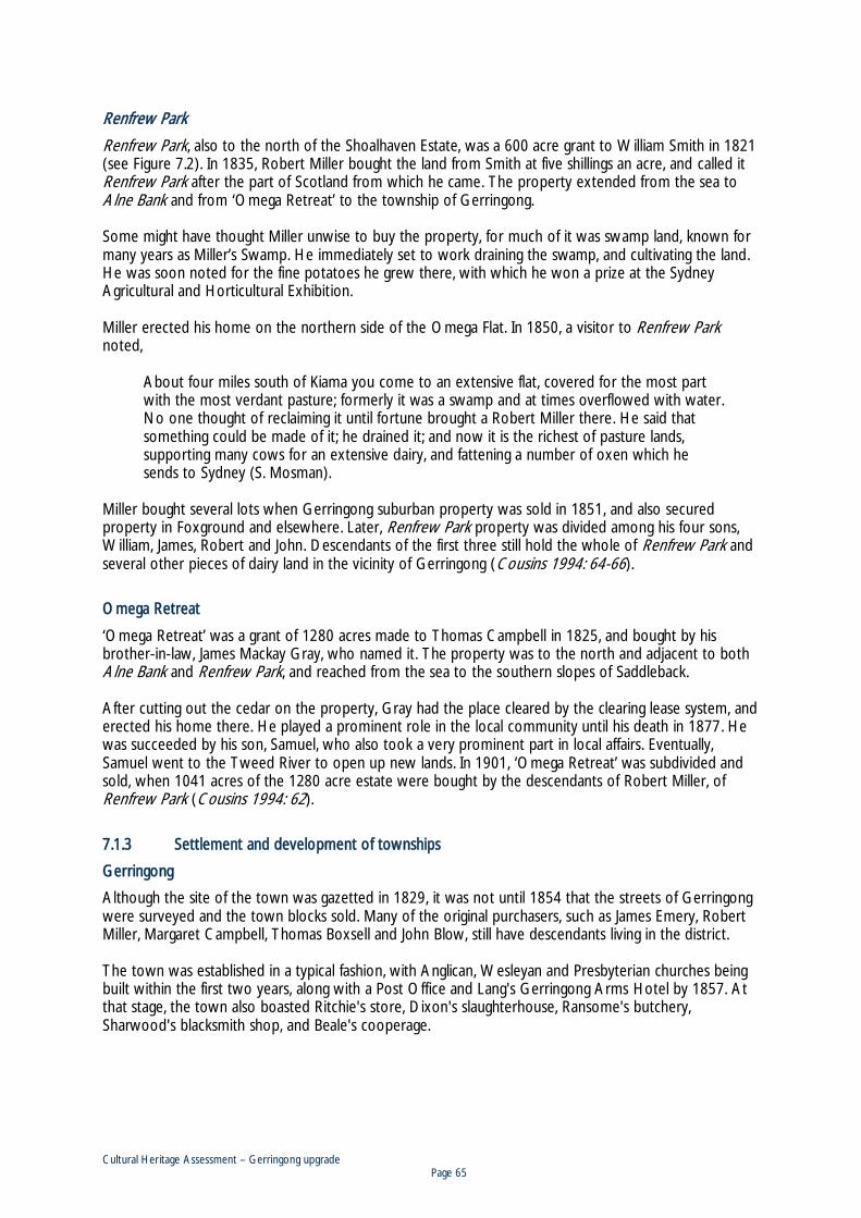
RRenfrew Park
Renfrew Park, also to the north of the Shoalhaven Estate, was a 600 acre grant to William Smith in 1821 (see Figure 7.2). In 1835, Robert Miller bought the land from Smith at five shillings an acre, and called it Renfrew Park after the part of Scotland from which he came. The property extended from the sea to Alne Bank and from ‘Omega Retreat’ to the township of Gerringong. Some might have thought Miller unwise to buy the property, for much of it was swamp land, known for many years as Miller’s Swamp. He immediately set to work draining the swamp, and cultivating the land. He was soon noted for the fine potatoes he grew there, with which he won a prize at the Sydney Agricultural and Horticultural Exhibition. Miller erected his home on the northern side of the Omega Flat. In 1850, a visitor to Renfrew Park noted,
About four miles south of Kiama you come to an extensive flat, covered for the most part with the most verdant pasture; formerly it was a swamp and at times overflowed with water. No one thought of reclaiming it until fortune brought a Robert Miller there. He said that something could be made of it; he drained it; and now it is the richest of pasture lands, supporting many cows for an extensive dairy, and fattening a number of oxen which he sends to Sydney (S. Mosman).
Miller bought several lots when Gerringong suburban property was sold in 1851, and also secured property in Foxground and elsewhere. Later, Renfrew Park property was divided among his four sons, William, James, Robert and John. Descendants of the first three still hold the whole of Renfrew Park and several other pieces of dairy land in the vicinity of Gerringong (Cousins 1994: 64-66).
Omega Retreat
‘Omega Retreat’ was a grant of 1280 acres made to Thomas Campbell in 1825, and bought by his brother-in-law, James Mackay Gray, who named it. The property was to the north and adjacent to both Alne Bank and Renfrew Park, and reached from the sea to the southern slopes of Saddleback. After cutting out the cedar on the property, Gray had the place cleared by the clearing lease system, and erected his home there. He played a prominent role in the local community until his death in 1877. He was succeeded by his son, Samuel, who also took a very prominent part in local affairs. Eventually, Samuel went to the Tweed River to open up new lands. In 1901, ‘Omega Retreat’ was subdivided and sold, when 1041 acres of the 1280 acre estate were bought by the descendants of Robert Miller, of Renfrew Park (Cousins 1994: 62).
7.1.3 Settlement and development of townships
Gerringong
Although the site of the town was gazetted in 1829, it was not until 1854 that the streets of Gerringong were surveyed and the town blocks sold. Many of the original purchasers, such as James Emery, Robert Miller, Margaret Campbell, Thomas Boxsell and John Blow, still have descendants living in the district. The town was established in a typical fashion, with Anglican, Wesleyan and Presbyterian churches being built within the first two years, along with a Post Office and Lang's Gerringong Arms Hotel by 1857. At that stage, the town also boasted Ritchie's store, Dixon's slaughterhouse, Ransome's butchery, Sharwood's blacksmith shop, and Beale's cooperage.

Cultural Heritage Assessment – Gerringong upgrade Page 66
Initially transport to and from the area was by sea, and regular shipments of dairy produce and timber were despatched to Sydney from Boat Harbour. This was a difficult proposition in bad weather, but a jetty was not constructed until 1880. Meanwhile, a road was cleared from Kiama in 1849, winding around the spurs to Mount Pleasant, then across the flats at Omega and up the ridge to the township and on to Crooked River. The railway came to Gerringong in 1893, when the extension from Bombo to Bomaderry was opened. A disastrous fire, fanned by a strong westerly wind, destroyed most of the town in July 1872, shortly after the formation of the Gerringong Municipality on 24 April of the previous year. The original municipal boundaries covered the area from Mount Pleasant to Crooked River and west to the headwaters of Broughton Creek. This area was augmented in 1896 with the addition of Toolijooa and the Municipality remained in existence until it was absorbed into the Kiama Municipality in 1954. Gerringong was without a school until 1876, although schools were by then in existence at Omega, Foxground and Toolijooa. Following the construction of the Gerringong School, and its subsequent expansion in 1924, the other local schools were eventually closed. With the expansion of the dairy industry, dairy factories were established in February 1888 at Gerringong, in January 1889 at Foxground, and later the same year at Toolijooa. Only the Gerringong Co-op still survives, as one of the oldest continually-operating dairy co-ops in Australia. By the end of the nineteenth century, the Gerringong area was home to about 400 adults, and probably supported a total population in excess of 1500. Aside from the commercial area of the town, almost all employment in the district related to the dairy industry.
FFigure 7.6: View of Gerringong from Mount Pleasant
Source: State Records NSW photo ID: 12932-a012-a012X2443000001.jpg

Cultural Heritage Assessment – Gerringong upgrade Page 67
77.1.4 The dairy industry
Alexander Berry, being the first in the area to create the concept of a farming village community, also became the first to set up a dairy on the South Coast. Within two years of his arrival, he recorded that, “a shipment of farm produce to Sydney … included in this shipment 78 lbs of butter and 20 cheeses”. So, by the end of 1824 his first dairying trade with Sydney Town has begun. Within another 10 years or so the dairying herd at ‘Coolangatta’ had increased in quantity and quality. While the first dairy structures were hurriedly installed and crudely made from packed mud, as the brickfield production improved, later buildings were more substantial. A large dairy was developed on his grants south of the river at Jindiandy, close to Upper Numbaa and strategically placed three miles from the river bank so as to reduce the risk from flooding. After his arrival in 1836, John Berry, who managed the Shoalhaven Estate, changed its emphasis from agriculture to stock breeding and the production of beef. He was said to have lived on horseback and was eventually thrown from his horse on 15 April 1848, dying from injuries four days later. With John Berry’s death and in 1849 the introduction of tenant farmers, the early days of the Shoalhaven being a breeding ground for young stock drew to a close. Twenty acre plots were leased rent free on the condition that they were cleared and fenced by the end of two to five years. By 1850, the leasing of the estate started and the tenant farmers began to establish dairying as the chief industry of the Shoalhaven district. By the 1870s most of the cedar had been cut out and the clearing leases had given way to farms - originally for wheat production. Eventually wheat growing was replaced by dairying (Bayley 1975: 34-37, Sealy 2000: 107). Bayley (1976: 89) contends that Kiama was the birthplace of dairying in Australia; it was the centre that first tried to export butter to England and it pioneered the system of factory production. A Butter Export Co-operative Co. was formed in 1870 and efforts were made to export butter to London and India, with an initial measure of success. The Kiama Pioneer Co-operative Dairy Factory was officially opened on 18 June 1884 and was the first of its kind in Australia. It was situated near Spring Creek on the Jamberoo Road. A monument commemorating the butter factory now stands at that location. Further south, other dairy factories were established between 1884 and 1894. These were the Kangaroo Dairy Co. (1888) on Sawyers Creek one kilometre south of the Berry Road along Factory Road; the Barrengarry Butter Factory (1888 to 1925); the Kangaroo River Dairy Co. (1890); and the Upper River Butter Factory on the eastern bank 16 km south of the Gerringong Creek junction (1894-1901). When it was opened in September 1895, the Berry Central Creamery was described as the ‘largest and most complete butter factory in the colony’. At that time it was noted that 1075 tons of butter were produced annually in the Berry district from 12,800 cattle, the product of which could be treated by the Berry Central Creamery. The registered trade mark was a bunch of berries (Lillipilli). In 1911, a group of dairymen purchased the creamery from the Berry Estate and formed a co-operative, which subsequently became the Berry Rural Co-operative Society Ltd. The milk market continued to grow and in 1958 butter manufacture ceased. A peak annual milk intake was reached in 1976-77 but a downward trend developed in the 1980s. From 1991, milk was collected from farms in the Co-operative’s tankers and delivered direct to the Australian Co-operative Foods Limited Factory at Bomaderry (Lidbetter 1993:14-15). The sub-division of the Berry Estate over the 40 years following the death of David Berry created many small dairy farms on both sides of the Shoalhaven. Examples of the style of dairyman’s weatherboard house, bails and other outbuildings survive from the period around 1900, such as Knapp’s property at 680 Bolong Road, Bomaderry, conveniently close to a dairy factory and the railhead (Freeman 1998:23).

Cultural Heritage Assessment – Gerringong upgrade Page 68
During the last decade of the nineteenth century, when Alexander Hay was the Manager of the late David Berry’s ‘Coolangatta Estate’, a more scientific approach was adopted towards dairying in the Shoalhaven. Following an investigative trip to Europe by Alexander, the Trustees of the estate erected the abovementioned butter factory at Berry and established a select herd of imported pure bred dairy cattle purchased on their native pastures, and placed it on a stud farm at Coolangatta. At that time, two public institutions of importance to the dairy farmers of the district were established at Berry. At the urging of Alexander Hay, a Bill was passed through the NSW Parliament to vary the Will of David Berry to the extent that a stud farm and an experimental farm should share in the endowment bequeathed by him for a cottage hospital established at Berry. That was agreed upon and a transfer of Port Jackson foreshores belonging to the estate and judged to be of equal in value to the endowment was satisfactorily arranged. The Crown then assumed the Trusteeship of all three institutions (the hospital, stud farm and experimental farm) and established them at Berry (Antill 1982:355). The Berry Experiment Farm opened near the river beside the road to Coolangatta in October 1899, being the first of its kind on the coast. It continued under the Department of Agriculture until in April 1934 it was taken over by the Child Welfare Department. It was remodelled with the provision of a dining room, dormitories and other facilities with cottages to house 40 boys to take farm training. In 1939, additional buildings were added, together with more modern farming facilities. In the 1970s the Child Welfare Training Farm closed and re-opened as a holiday home for the underprivileged and was later transferred to the Department of Sport and Recreation (Bayley 1975: 206, Berry Museum 2006:2). In 1903, the government stud farm at Berry was described as, ‘the most important institution on the coast from the dairymen’s point of view. It is well situated, and is within two miles of the town. On one side it has a mile frontage to the deep, navigable waters of Broughton Creek, and the new Mooeyan Bridge connects it with Berry and the railway’ (Town and Country Journal, 11 February 1903). From the above descriptions of the experiment and stud farms, it appears that the two were co-located between what is now Moeyan Road and Coolangatta Road and Broughton Creek, approximately two kilometres south of the present town of Berry. In the 1920s, a Pasture Research Unit was established off Wharf Road, Berry, by the Department of Agriculture. In the 1950s, the in New South Wales was established at that location, and in 1958, it was moved to Graham Park, south-west of Berry on the Princes Highway. The first artificial insemination breeding station, which was established by the NSW Milk Board, occupied a total area of approximately 75 ha, including bull yards, buildings and a quarantine area from which the semen collection and processing occurred. In the 1990s, the centre closed and the buildings were used by Wollongong University, until new premises were built for them in 2000 in Nowra (Berry Museum 2006: 2).
77.1.5 The development of the main road between Kiama and Bomaderry
Although not supported by direct European historical observations, it is highly probable that the local Aboriginal people used and maintained trails across the Southern Illawarra coastal plain. These are likely to have taken advantage of natural corridors, such as creeks and rivers, ridge and spurline crests, and the elevated ground between swamp basins, Other factors which may have influenced Aboriginal cross-country routes, were the incidence of thick ‘brush’ or lowland rainforest, and the location of saddles and passes providing passage across the Cambewarra Range. The purposes and destinations which would have governed an Aboriginal network of trails would not have corresponded with the differing economic and communication interests of the early European inhabitants. However, it is probable that where Aboriginal trails coincided with European interests, trails would have been used and quickly formalised into bridle trails and later into paths and tracks. There is some limited evidence for this process across the Illawarra Ranges where natural passes and interconnecting routes became important for inland communication, and the movement of stock and early diary produce (Officer 1991a, Griffith 1978).

Cultural Heritage Assessment – Gerringong upgrade Page 69
The first European established roads were most probably sawyers’ tracks, which allowed the hauling of felled red cedar logs from the hinterland forests to points of maritime access such as coastal ports and navigable streams. This activity would have commenced with the first cedar harvesting in 1812. The regular maritime transport of logs to Sydney provided as a secondary function, a means of transport and communication for European settlement, and the sea corridor dominated regional transport well into the late nineteenth century. An alternative to inland trails was provided by a rough coastal track which developed informally to link the coastal settlements from Bulli, south to Kiama. The ‘track’ consisted of a series of headland traverses that allowed access onto the intervening beaches. Creek, river and estuary mouths were a hazard which could be crossed depending on local conditions and the depth of sand barriers. European settlement followed the initial incursions of the cedar getters, and as this occupation extended beyond maritime access points, centres of habitation became linked by informal trails which developed into tracks with continued use. Following the steady alienation of crown lands via government grants and sales, the use of such early tracks became an increasing source of dispute, across the Illawarra, as the rights of private landholders began to be asserted. Amongst the complaints were those of Alexander Berry who stated that his property was being trespassed upon for want of a proper road (J.M.E. 1951:76). Increasing pressure from landholders to survey and establish public roads resulted in an expedition by Surveyor General Mitchell which by 1834 had formalised a road route between Appin and the northern Illawarra via Broughtons Pass and Mount Keira. In addition to a northerly extension to Bulli, the road was extended southwards ‘as far as Saddleback Mountain to connect some miles inland with a line marked from Kiama to Bong Bong by Surveyor Hoddle in 1830’ (J.M.E. 1951:77). Mitchell begged ‘to observe that the continuance of a great road further south than the Nurrima Range [Saddleback Mountain] should be considered with reference to the passage of the Shoalhaven River and the best direction for a thoroughfare through the Coast Country of St Vincent’. Mitchell was, ‘of the opinion that the valley of Broughton’s Creek would be the best direction for it to cross...’ (in JME 1951:77). In 1841 a petition by Gerringong residents to Governor Gibbs stated:
‘That your Petitioners grievously labouring under the many disadvantages arising from the Want of a practicable Road on the south side of Kiama do humbly pray your Excellency That you may be pleased to allow a continuation of the Jamberoo Parish Road to be surveyed through Kiama as far as Gerringong...’ (in JME 1951:78).
Shortly after, a new line was marked to Gerringong to replace the old track which wound round the headlands (JME 1951:78; Cousins 1948:96). In 1844 it was noted that the Kiama to Gerringong road was not metalled (Cousins 1948:192). Locals residents remember local oral tradition that the original road from Mount Pleasant avoided the poorly drained lowlands of Omega Flat (Ooaree Swamp) and turned westward to traverse the swamp’s fringing basal slopes. The road approximated the current alignment of Rose Valley Road to ‘Taballa’ then turned south-east, crossing the valley floor to join Alne Bank Lane. Alne Bank Lane crossed the future alignment of the South Coast Railway Line north of Sims Road, and entered Gerringong via Rowlins Road (email correspondence from Michael Hindmarsh to Ron de Rooy, 29 Sep 2009). A map dating from the 1840s shows the presence of a direct southerly route across the swamp, and a more prominently marked westerly deviation (see Figure 7.7). In 1849, a new line of road was cleared between Kiama and Gerringong (Latona Masterman & Assoc 1987:9; www.gerringong-gerroa.com). Michael Hindmarsh (of Alne Bank) and James Mackay Grey (of Omega Retreat) were the successful contractors for the construction of the new road. By the 1860s, only the direct southerly route is marked on maps, suggesting that by this time, agricultural drainage of the valley floor had been achieved.

Cultural Heritage Assessment – Gerringong upgrade Page 70
The grid network of roads that formalised the Gerringiong township was laid out in 1854.
FFigure 7.7: Extract from map of the County of Camden 1843 -46. The only road shown extending south from Kiama at this time (highlighted in white), passed through Gerringong and traversed Seven Mile Beach to Berry’s settlement at ‘Coolloomagatta’. Despite the schematic delineation of the road, it is clear that a shortened route across Omega Flat (dashed, across the Smith’s portion), is paired with a more regularly used deviation around the swampland across Hindmarsh’s portion.
Source: Map of the County of Camden: dedicated by permission to Sir T.L. Mitchell, Knt., Surveyor General of New South Wales / compiled expressly for the printer and publisher of the Australian Atlas, W. Baker, Hibernian Printing Office, King Street, East Sydney National Library of Australia nla.map-raa8-s7-v A meeting at Kiama, in 1841, to discuss extending the road from Saddleback Mountain to the Shoalhaven failed to result in any official action (JME 1951:81). Fifteen years later, in 1856, Surveyor Shone was required to mark a line from Gerringong to Broughton Valley and to report on the expediency of extending the line to Bomaderry. Following further official inaction, Alexander Berry took the initiative, and privately constructed a road across his estate lands from Gerringong to Broughton Creek (Berry) and later to Bomaderry by 1858 (JME 1951:81; Cousins 1948:105). It is this private road that is presumably shown on an 1866 map of the County of Camden (see Figure 7.8). The alignment of this road established a transport corridor which has been retained to the present day, with many sections of the Princes Highway retaining the original alignment. The Berry Estate road was distinctive in its use of long straight sections, which often traversed steep spurs and ridges without apparent regard for the consequentially steep gradients. The straight and sometimes steep nature of the road may be explained by:

Cultural Heritage Assessment – Gerringong upgrade Page 71
The need to minimise length and consequential costs. Pressure to establish a road link in a minimal time period. The absence of cadastral or land ownership limitations which would otherwise required deviations
and bends. The predominant early use of bullock teams to convey produce, and thus a greater tolerance of
moderate gradients. On the 9 August 1858, the Illawarra Mercury reported that a road was to be proclaimed from Gerringong to the head of Broughton Creek. It was to be maintained at the expense of the parishes which it traversed. Bayley (1975) notes that the road from Gerringong to Broughton Creek was gazetted by the government in 1858 and Berry set men to open the road from Gerringong to Bumaderry Creek (Bayley 1975:51). In August the following year the Illawarra Mercury reported that
‘Mr David Berry is also busy in the march of progress. He is opening the new road from Bumaderry [Bomaderry] to Broughton’s Creek, and from the number of men employed quarrying stone, and brick making at Bumaderry, Mr Berry appears at last to have an eye to the future advancement of the district.’ (8 August 1859).
In September 1859, a Municipal Council of Shoalhaven was proclaimed and meetings of elected councillors commenced. Alexander Berry however objected to the inclusion of his estate lands within the boundary of the municipality, and following both a Supreme Court injunction and an appeal to the Privy Council, the area was declared illegal and the council become defunct. On the 8 December 1859, the Illawarra Mercury, reported on the unanimous passing by council of ‘a resolution of Mr Bice, ‘as to the necessity for the immediate survey of the road from Bomaderry to Kiama,’ which is very important to the district...’. In the early 1860s, the government provided 140 pounds to be spent on the road between Kiama and Broughton Creek, roughly ten pounds per mile (Cousins 1948:232). Antill (1982) states that the road from Broughton Creek to Bomaderry was completed and opened for use in July1869, despite many potholes left by the removal of tree stumps. Bridges over the creeks on the new road between Bomaderry and Gerringong were completed in October. (Antill 1982:82). Prior to Berry’s estate road via Broughton Creek, terrestrial travel southwards had been via Seven Mile Beach, with a crossing of the Crooked River near modern Gerroa. Further travel was via the north bank of the Shoalhaven, past Berry’s Coolangatta homestead, to a ferry crossing at Numbaa. Following the completion of the Berry estate road, the ferry service was moved to Bomaderry. A government ferry commenced operation at the Bomaderry crossing in May of 1866 (Shoalhaven Heads website) Following the cessation of the Shoalhaven Council, two alternative Municipalities of Numba, (south of Shoalhaven) and of Broughton Creek and Bomaderry (north of the river) were proclaimed in 1868. Many of the roads and bridges constructed by the Berry Estate served as the region’s main transport corridors, and consequently came under the jurisdiction of the new councils. These roads were proclaimed, prior to the councils commencing systematic clearing and stumping, together with the construction of small bridges and culverts. Much of this work had to be done on the Gerringong road and contracts were let in different sections, some at 15 shillings, some at 17s and some at 19s6d, a chain. Bridges across some of the creeks were also constructed, one for 23 pounds 7s6d, and another for 16 pounds (Shoalhaven News in Cousins 1948:266; JME 1951:81).
Cultural Heritage Assessment – Gerringong upgrade Page 72
In 1872, a correspondent to The Sydney Mail described the road in the following way:
‘The road from Jerringong to Broughton Creek is a very hilly one, and, in parts, rough and unformed, though much has been done towards the making and completion of it; and the bridges and culverts are as excellent as they are numerous. Almost the whole of it runs through Mr Berry’s estate, over ridge and valley, among pasture farms and comfortable homes, and by tall dead trees rising against the sky, white and ghastly, but relieved by the waving plumes of the cabbage trees that are largely intermixed with them... ‘ and a good deal of “corn” is grown in places; but from the crossing at Upper Broughton Creek until a view is gained at the big rich valley of Broughton Creek proper, few homesteads are visible. The “bush’ is still in a comparatively wild state, though there are “clearings” on either side that cannot be perceived from the road.’ ‘...From Broughton Creek to the Shoalhaven at Bomaderry ferry, the road is still less formed than that leading to the Creek; but it has the advantage of being comparatively level, and is in course of improvement, It is lined almost throughout with splendid trees, straight as a ship’s mast, and far taller; the size and closeness of these make the task of clearing the land a very heavy one; but even here there are “clearings” and some of the most luxuriant corn in the district.’ (The Sydney Mail May 4 1872:p558)
The first road constructed by the Broughton Creek and Bomaderry Council was a new line between Broughton Creek (Berry) and Broughton Village in the late 1870s. The new alignment was laid to avoid many of the steep gradients involved in the original alignment which was laid out by Surveyor Mann. Once abandoned, the old alignment was known as “Mann’s Folly” (Bayley 1975:131). The works continued to the end of 1877 and included the construction of bridges, culverts and drains. The new road was reportedly surveyed by the Council’s Mayor, James Wilson (Robson and Knevitt 2008:9). In September of 1874, The Sydney Mail noted that Mr Morton, an agent to Mr David Berry, met with the Mayors of Broughton Creek and Broughton Vale, ‘to mark out and define the lines of road, recently very kindly granted by Mr Berry’. One of the lines is described as ‘serviceable for such as have business to Gerringong and Kiama’ and almost certainly refers to the estate road initially established in the 1850s. By 1878 it was reported that:
‘The Broughton Creek Municipal Council is forming a very good, though circuitous road between Broughton Village and Broughton Creek. There is about twelve chains of road, known as Tates Hill, under the control of the Gerringong Council urgently needing attention.’ (Sydney Moring Herald May 4 1878:619).
The first bridge over Broughton Creek is thought to have been constructed at about the same time, in the 1870s (BDHS website), with a subsequent timber truss bridge probably being erected in the 1890s (RTA s170 register, Broughton Creek bridge citation). However a news article in May 1878 notes that ‘the Broughton Creek bridge is dangerous and needs extra support so also does the bridge at Broughton Village; if a flood occurs, both would most likely be swept away’ (Sydney Moring Herald May 4 1878:619). A news item in the Sydney Morning Herald on August 27 1889 notes the final availability of funds from the Department of Works for the proposed bridge over Broughton Creek, just north of Broughton Village. The second main road bridge to span Broughton Mill Creek at Broughton Creek (Berry) was opened in 1888 at a cost of £1856 (Bayley 1975:136; Shoalhaven Heads website).

Cultural Heritage Assessment – Gerringong upgrade Page 73
In August 1888, The Sydney Moring Herald reported that the Minister of Works had assured the Gerringong Municipal Council that a sum of £1000 would be provided, and that:
‘...on the strength of that assurance an important piece of work at the place known as Brown’s Hill would be commenced forthwith. The Brown’s Hill is the only acclivity of much importance on the main road between Broughton Village and Gerringong, and when the proposed improvements are erected this line of road would be one of the best on the South Coast, the council having recently made two or three similar alterations at a cost of several hundred pounds, where the hilly nature of the country presented difficulties to travellers’ (Sydney Moring Herald 11 August 1888: 312).
In January 1889, the Department of Works granted the Gerringong Municipal Council £500 to recoup in part ‘money expended with carrying out certain deviations on the main road between Gerringong and Broughton Vale’ (Sydney Morning Herald 29 January 1889: 7). In the following year it was noted that ‘the survey and plan of the proposed alteration in the main south road near Broughton Village would soon be completed (Sydney Morning Herald 10 May 1890: 1060). Construction of the steel whipple truss bridge over the Shoalhaven River (the ‘Nowra Bridge’) was commenced in 1879 by Edgemoor Iron Co. of Delaware, and completed in 1881. The bridge was the largest in NSW at that time and cost £42,500. The bridge was intended to also carry rail traffic but was later considered to have insufficient strength. The extension of the South Coast Railway Line from north Kiama (now Bombo) to Bomaderry was opened in June 1893 (Shoalhaven Heads website). In the period between Berry’s original construction of the estate road from Gerringong to Bomaderry in the late 1850s, and the 1890s, the further development of the road by the local councils resulted in a longer and more angular alignment, involving switch-backs and deviations around spurs. This is evident in a comparison of the 1866 and 1895 County Maps (see Figure 7.8 to Figure 7.12). The elaboration of Berry’s originally straight alignments appears to have been a consequence of establishing more gradual grades, suitable for horse drawn vehicles, and complying with various tenant farm boundaries and related cadastre.

Cultural Heritage Assessment – Gerringong upgrade Page 74
FFigure 7.8: Extract from an 1866 map of the County of Camden, showing the location of roads between Kiama, Gerringong, Broughton Creek (Berry) and Bomaderry, highlighted in blue. Note the alignment of the Berry estate road between Gerringong and Bomaderry which comprises many straight sections with minimal bends and deviations.
Source: County of Camden, New South Wales, 1866 compiled by Messrs Braddock & Baly, & engraved by John L. Ross. National Library of Australia 1866. MAP RM 1798. Part 2; http://nla.gov.au/nla.map-rm1798-s1-sd-cd

Cultural Heritage Assessment – Gerringong upgrade Page 75
FFigure 7.9: Extract from an 1866 map of the County of Camden, showing the location of roads in the vicinity of the Gerringong upgrade proposal area
Source: County of Camden, New South Wales, 1866 compiled by Messrs Braddock & Baly, & engraved by John L. Ross. National Library of Australia 1866. MAP RM 1798. Part 2; http://nla.gov.au/nla.map-rm1798-s1-sd-cd

Cultural Heritage Assessment – Gerringong upgrade Page 76
FFigure 7.10: Extract of an 1895 map of the County of Camden, showing the road between Gerringong and Bomaderry. Note how the development of the road by local councils, and following the break-up of the Berry estates has introduced numerous bends and irregularities from Berry’s original alignment
Source: Map of the County of Camden, Eastern Division, N.S.W. 1895 / compiled, drawn and printed at the Department of Lands, Sydney N.S.W. 24th June 1895. National Library of Australia http://nla.gov.au/nla.map-f262

Cultural Heritage Assessment – Gerringong upgrade Page 77
FFigure 7.11: Extract of an 1895 map of the County of Camden, showing the location of the roads between Kiama, Gerringong and Broughton Village, the vicinity of the Gerringong upgrade proposal area

Cultural Heritage Assessment – Gerringong upgrade Page 78
FFigure 7.12: Extract from an early 1890s map (probably 1892, refer Graham 1998), of ‘Part of the Berry Estates, Parishes of Broughton and Coolangatta, County of Camden’. The map records the boundaries of former tenant farms, their associated homesteads, and the road between Gerringong and Broughton Creek (Berry). The extract above shows the estate closest to Gerringong and within the Gerringong upgrade proposal area. The red line highlights the mapped roadway, the blue line is an approximate overlay of the road shown in the 1866 County map, and presumed to be the estate road constructed by Berry in the 1850s. Note that the 1890s road is more moderately graded, and deviates around cadastral boundaries.
Source: Map printed by Gibbs Shallard & Co. Sydney for Harper and Harper Civil Engineers, original at State Library of New South Wales, M_Ser4_000_1_MLMSS315_Map 17)

Cultural Heritage Assessment – Gerringong upgrade Page 79
Following the death of David Berry in 1889, the estate passed to his cousin John Hay. Hay developed a formal street grid for the town of Broughton Creek in the 1880s, on the west side of Broughton Mill Creek. This was surveyed in 1879 and well established by 1890 (Cousins 1948:262; RTA s170 register, Broughton Creek bridge citation). This provided for the future growth of the town beyond the limited area on the east of the creek where the original town had developed around the Pulman Street ridgeline. The new grid was orientated slightly differently to the existing emergent streetscape, and this resulted in many buildings being misaligned, necessitating their movement or realignment to the new pavements (Lidbetter 1993:19) (see Figure 7.13). Another consequence was that the existing road to Bomaderry which lead away from the town in a straight south-westerly trajectory would be truncated by the new grid, and a new approach road would have to be developed at the north-western corner of the grid. The current highway alignment follows this late nineteenth century revision. Hay established a street grid for the Bomaderry township in the following year 1891. In 1895, the bridge over Ooaree Creek (Omega Flat) was washed away in a flood (Cousins 1948:240). In 1913, M.F. Morton officially opened a new replacement bridge over Broughton Mill Creek (Bayley 1975:168). The approximate route of the current Princes Highway was declared the ‘Main South Coast Road’ through the Local Government Extension Act of 1906. However, in 1920, during a visit to Australia of the Prince of Wales, the National Roads Association secured approval from the Prince to name the coastal road after him. An opening ceremony was held at Bulli on the 19 October 1920. The road was formally proclaimed the Prince’s Highway (State Highway No.1) in 1928 under the Main Roads Act. From the passing of the Local Government Act in 1906, road maintenance and improvements were the responsibility of local councils. This meant that highway works were uncoordinated and tended to be local in nature, and driven by local needs. Many of the municipalities along the road depended heavily on the volunteer support of local landholders in the upkeep of the road. The construction of bridges was the responsibility of the Department of Public Works. Following the Main Roads Act in 1924, the formation of the Main Roads Board in 1925 marked the beginning of an integrated approach to highway maintenance and reconstruction. At its formation, the Board found that the highway through the Shoalhaven area consisted of gravel, broken stone or plain earth surfaces (Bayley 1975:178). The Board immediately embarked on a statewide program of improving roads to a standard to suit high speed automobile traffic. The Board first arranged with a number of councils for the urgent reconstruction or construction of portions of the highway, and later assumed full responsibility for the whole length of the highway to the Victoria border (excepting a short section through Wollongong), a length of around 342 miles. Outside of new and reconstructed portions, a program of gradual improvement was pursued, funded by annual maintenance and improvement budgets. This program included works such as widening of existing formations and pavements, improvements to crests and curves, elimination of V-gutters by the construction of culverts, erection of safety fencing, guide posts and the strengthening of pavements. By December 1932 the highway between Sydney and the Shoalhaven had been improved and most sections surfaced with a bituminous macadam. By 1951, the highway had a continuous bituminous surface from Sydney to Moruya (JME 1951:84; OzRoads website; RTA s170 Broughton Creek bridge register). Unemployment relief work was undertaken along the highway during the 1930s. The lookout at Mount Pleasant was constructed in 1935. In 1935-6 a new concrete bridge was constructed over Broughton Creek, on a short deviation, 650 m downstream of the original timber structure. The cadastral street grid of Broughton Village was bypassed by the new alignment. 1936 also saw the completion of a 1.7 km deviation through steep country to the south of the creek. This section included what is now known as ‘The Big Dipper’, and cut off a tight bend known at the time as ‘Binks’ Corner (OzRoads website; Parish map of Broughton 6th edition 1916-1938).

Cultural Heritage Assessment – Gerringong upgrade Page 80
FFigure 7.13: Extract from County and Parish maps showing the change in the orientation of the main south road through Broughton Creek (Berry), from a south-west to an east-west alignment occasioned by the establishment of a street grid in the 1880s
Source: County of Camden 1866
Source: County of Camden 1895
Source: Parish of Coolangatta 4th Ed

Cultural Heritage Assessment – Gerringong upgrade Page 81
FFigure 7.14: Extracts from a 180 degree panorama photo (top), looking roughly west (middle) and east (bottom), along the highway in the 1920s, from a point just west of Gerringong. The middle view is towards the current location of the Crooked River Winery reception buildings, and the bottom view looks across the Crooked River towards hills to the south of Gerringong.
Source: From a photo of the ‘Homeleigh’ property by R.P Moore 379 Kent Street Sydney, in the collection of Geoff Bailey, Homeleigh Gerringong). The remains of the road portion shown in these photos constitutes heritage recording G2B H401, refer SSection 8.4.1.

Cultural Heritage Assessment – Gerringong upgrade Page 82
Between 1936 and 1938, a 2.3 km deviation between Omega and the Gerringong railway stations was constructed (Figure 7.15 to Figure 7.19). This was known as the Omega deviation (or Gerringong bypass) and removed two railway crossings along the former highway route in and out of Gerringong along Fern Street and Belinda Street. The 1930s also saw the construction of the Bomaderry deviation, commencing just south of Tullian Creek and bypassing Bomaderry to the west. The former highway is now known as Meroo Road. The reconstruction of the highway was halted in 1941 due to the onset of war in the pacific, with funds and manpower being transferred to major defence routes. One of these was the Mount Ousley Road which provided an alternative descent of the Illawarra Escarpment (OzRoads website). 1941 also saw the possessive form removed from the highway name, which became simply the ‘Princes Highway’ (OzRoads website). In 1954, the highway was included in the National Route system as part of National Route 1. Signage was erected along the length of the highway during June 1955 (OzRoads website). In 1955, an inspection of the Broughton Mill Creek bridge at Berry was made by an appointed administrator of the Shoalhaven Shire, Keith Hawkshaw, who called for a report from the council engineer on an innovative design of pile for a new bridge. Due to the difficult approach to the bridge, many accidents had occurred. Hawkshaw agreed with Berry residents that actions were required. A new concrete bridge on a new alignment was opened in 1958 (Bayley 1975:213; Robson and Knevitt 2008:48-49). The 1960s brought the completion of the reconstruction and sealing plan that had been started in 1925. The bitumen finally reached the Victorian Border in 1965. In 1980, a new three-lane bridge to carry northbound traffic was constructed immediately upstream and adjacent to the 1881 Shoalhaven River steel truss bridge which continued to carry two lanes of southbound traffic. The new bridge cost $2.9m. In 1989 the roundabout at the intersection of the highway and Moss Vale Road (SR79) was installed. Dual carriageways were completed through Bomaderry in December 1993.

Cultural Heritage Assessment – Gerringong upgrade Page 83
FFigure 7.15: View looking southwards along the new ‘Omega Deviation’ (Gerringong Bypass), State Highway 1, from front of Renfrew Park, Sep 1938
Source: State Library of NSW: Gov Printing Office 1-32514; d1_32514r
Figure 7.16: View looking south-west along the ‘Omega Deviation’ in 1938, opposite the intersection with Fern Street. Note the Omega Stationmasters residence in the middle distance
Source: State Library of NSW d1_32515r

Cultural Heritage Assessment – Gerringong upgrade Page 84
FFigure 7.17: View of rock cuttings along the ‘Omega Deviation’, in 1938 looking south-west
Source: State Library of NSW d1_32508r
Figure 7.18: View of the southern end of the Gerringong Bypass completed in 1936, looking east. This section of the bypass cut off a number of bends, shown in the 1920s view, Figure 7.14.
Source: State Library of NSW d1_27031r

Cultural Heritage Assessment – Gerringong upgrade Page 85
FFigure 7.19: Extracts from the Parish map of Broughton 6th Edition (above) and the 7th Edition (below) showing alterations to the local road network arising from the Gerringong bypass, constructed in 1938

Cultural Heritage Assessment – Gerringong upgrade Page 86
77.2 Previous cultural heritage studies and inventory of listed heritage items
The Gerringong upgrade is situated within the assessment areas of a number of heritage studies, notably the Kiama Heritage Study (Latona Masterman & Associates (1987), a number of follow-up heritage reviews conducted by, or on behalf of, Kiama Municipal Council (Perumal Murphy Wu Pty Ltd 1994; Simpson Dawbin 2000; www.nsw.nationaltrust.org.au/sohkiama.html), and a study of stone walling around Kiama (Mayne Wilson and Associates 2000). A detailed review of previous heritage studies was prepared for the Gerringong to Bomaderry Princes Highway Route Selection study (Navin Officer Heritage Consultants 2007b). The reader is referred to this previous study for detailed information on the subject. The Kiama Municipal Council has been conducting a review of non-Aboriginal heritage items since 1998. It is currently in the process of preparing and approving a draft local environmental plan amendment for heritage items and a revised heritage schedule. Kiama Municipal Council has kindly provided details of items from that draft that are within or near the study area. The Navin Officer 2007 review found 62 recorded heritage items within the boundaries of the Gerringong to Bomaderry route selection study area (an area that was approximately 27 km long and up to four kilometres wide). The current assessment however is focused on a small portion of the original review area and has correspondingly identified four listed items within or near (up to 500 m) the anticipated upgrade footprint. The revised draft Kiama heritage schedule includes nine relevant items. Table 7.1 and Table 7.2 identify these items. Of the four listed items, only one appears on statutory listings. This is the Renfrew Park homestead and grounds which is listed on the heritage schedule of the Kiama Local Environmental Plan 1996 and the Illawarra Regional Plan of 1986. It is also included on the NSW Government Heritage Inventory, and included on the register of the National Trust (NSW). A portion of the grounds in front of Renfrew Park homestead would be directly impacted by the upgrade. The remaining three items are the Innisfail homestead, the Kiama Dry Stone Walls Conservation Area, and the Berry District Landscape Conservation Area. Innisfail is listed on the Royal Australian Institute of Architects 20th Century Register of Significant Buildings. The driveway entrance of this property would be directly impacted by the upgrade works. Both the conservation areas are a consequence of National Trust (NSW) evaluations, and are included on their register. They also appear as Indicative Places on the Register of the National Estate. There are nine items on the draft Kiama Heritage Inventory which occur within or near the upgrade study area. All of these draft listings are assessed as having local heritage significance. All of the draft citations describe built structures but it is unclear if they include the estate lands, ornamental gardens (or remnants thereof). The citations are yet to define cartilages. If only the built environment is to be listed then no draft inventory items would be directly impacted by the upgrade works. This is probably an unsafe presumption however, and based on some incidental references to large trees and landscaped grounds it should be assumed that any final listings arising from these drafts would variably include adjacent grounds. Four of the draft items, the Gerringong Dairy Co-op, the old Gerringong Stationmasters cottage, the former (now relocated) Toolijooa Schoolhouse, and the Strathmore homestead, are all situated well away from the upgrade footprint, including their associated lands. The surrounding garden and grounds of one item, the Aorangi homestead, would be situated immediately adjacent to the upgrade footprint, but the grounds should not be directly impacted. The associated lands of the remaining four items would be directly impacted along their property margins. These are the Ivy Mount, Innisfail and Renfrew Park homesteads and the former Omega Public School building. Of these, the potential for significant impact associated with the loss of ground is least at Omega Public School, and greatest at Renfrew Park.

Cultural Heritage Assessment – Gerringong upgrade Page 87
TTable 7.1: Recorded heritage items by type and individual heritage schedule within or near (within 500 m) of the upgrade study area. (Numbers in the left hand column relate to the inventory complied in the Navin Officer Heritage Consultants 2007 review).
Item Statutory listing Non--Statutory listing
No. Name Location HR RC s170
RTA s170
Kiama LEP 96
Illaw. REP 86
RNE HI RAIA NT (NSW)
7 Berry District Landscape Conservation Area
Embraces the coastline south of Kiama some 30 km southward to Greenwell Point, the undulating coastal plain and the flood plain on both sides of the lower Shoalhaven River and including the steep, benched slopes rising up to the escarpment of the Illawarra plateau.
(IP)
14 Innisfail homestead 252 Princes Highway, Willow Vale (Toolijooa)
32 Dry Stone Walls Conservation Area Princes Highway, between Kiama and Gerringong. Distributed in the area between Kiama, Jerrara and Rose Valley.
(IP)
34 Renfrew Park homestead and grounds Princes Highway, Gerringong
HR = NSW Heritage Branch Heritage Register; RRC s170 = RailCorp Section170 Heritage and Conservation Register; RTA s170 = Roads and Traffic Authority Section 170 Heritage and Conservation Register; Illaw REP 86 = Illawarra Regional Environmental Plan 1986 Kiama LLEP 96 = Kiama Local Environmental Plan 1996 – Schedule 2; SShoalhaven LLEP 85 = Shoalhaven Local Environmental Plan 1985 – Schedule 7; RRNE = Register of the National Estate (R = Registered, IP = Indicative Place); HHI = NSW Heritage Branch Heritage Inventory; RRAIA = Royal Australian Institute of Architects 20th Century Register of Significant Buildings; NNT = National Trust of Australia (NSW).

Cultural Heritage Assessment – Gerringong upgrade Page 88
TTable 7.2: Heritage items within or near (within 500 m) the upgrade study area which are identified in the Draft Kiama Heritage Inventory (DKHI) 2007. (Numbers in the left hand column relate to the inventory complied in the Navin Officer Heritage Consultants 2007 review).
No. SHI inventory/ DKHI ID
Name Location Level of identified
significance
2 1860233 Aorangi homestead 121 Princes Highway, Toolijooa Local 4 1860111 Gerringong Dairy Co-op. 18 Belinda Street, Gerringong Local 6 1860194 Innisfail homestead complex 252 Princes Highway, Toolijooa Local 7 1860195 Ivy Mount homestead 24 Princes Highway, Gerringong Local 10 1860152 Old Stationmasters cottage 16 Belinda Street, Gerringong Local 11 1860165 Old (former) Toolijooa
Schoolhouse (relocated) 2 Victoria Street, (Cnr Belinda and Victoria Sts), Gerringong
Local
12 1860201/ KO5-15
Omega Public School (former)
49 Princes Highway Gerringong Local
13 1860003/ Vol 2
Renfrew Park residence 151 Princes Highway, Gerringong Local
14 1860238 Strathmore homestead 65 Willowvale Road, Willowvale Local
7.3 Predictive historical archaeology statement
Unrecorded historic sites and features of heritage significance that potentially may occur within the study area are likely to comply with the following predictive statements: a) Buildings and structures would be focused in the town and along the early centres and corridors of
occupation, agriculture, industry, travel and transport. b) Structures of historical interest and heritage significance may be standing, ruined, buried, abandoned
or still in use. c) Standing commercial and public buildings are most likely to survive within the towns and urban
landscapes. d) Nineteenth century structures, such as farm dwellings, outbuildings, selector's or tenant farmer
cottages may survive as standing buildings, ruins or archaeological deposits and are most likely to survive on less developed rural properties, on early portion numbers, and in or near established farm building complexes.
e) Former timber mills and associated infrastructure such as timber pole structures, remains of machinery, tracks and tramways may survive on the outskirts of the towns or adjacent to former or existing forested areas.
f) Traces of agricultural and industrial processing or extractive sites such as mills, dairies, factories, and quarries may be found throughout agricultural lands on the valley floor and adjacent low ranges.
g) Railway sites, features and infrastructure would be focused along the rail corridor. h) Sites associated with early roads would be closely associated with early private estate and cadastral
(public) road reserves, watershed ridgelines, and related to early river and creek crossing points. i) Archaeological sites such as the occupation remains of former dwellings including homesteads,
houses and huts, would be distributed in close association with land settlement patterns and correlated with favourable agricultural lands, trading nodes and transport corridors.
j) Transport and access routes such as bridle paths, stock routes, and highway alignments of varying forms and ages, may survive as abandoned remnants adjacent to modern transport routes, or as alignments now followed by more modern or upgraded road and track infrastructure.
Cultural Heritage Assessment – Gerringong upgrade Page 89
k) Old fence lines (such as dry stone wall and post and rail fencing) may occur along road easement boundaries and enclosed farmlands. Other indications of field systems, such as drainage channels and ridge and furrow ploughlands, may survive in low lying agricultural ground, especially in areas that are now used for grazing, rather than cropping.
l) Shipwrecks and the submerged remains of other structures or deposits, such as from wharves, jetties and piers, may occur on river and creek banks and beds.
m) Jetty wharf locations would tend to cluster at towns and adjacent to industrial sites.

Cultural Heritage Assessment – Gerringong upgrade Page 90
88.0 Results This chapter provides descriptions of Aboriginal and Non-Aboriginal heritage recordings within or in close proximity to the Gerringong upgrade study area. A summary of the recordings are presented in Table 8.1, Table 8.2, Table 8.3 and Table 8.4, and locations are shown in Figure 8.32 and Figure 8.109 at a small scale and on large scale aerial photography in Appendix A. Please note that the numbering of the recordings follows an inventory compiled for an archaeological survey of the whole of the preferred Princes Highway upgrade alignment between Bomaderry and Mount Pleasant (Gerringong). As a consequence, the start and finish numbers are variable.
8.1 Summary
Twelve Aboriginal heritage recordings occur within or near the proposal study area. These consist of two sites with surface artefacts (G2B A6 and G2B A7), one with reported subsurface artefacts (G2B A5) and nine potentially archaeological sensitive areas (PASA 31 to PASA 39). In addition to these recordings, the Aboriginal cultural value of mature fig trees across the Illawarra region is noted. There are five mature fig tree incidences, singly or in groups, in or near to the proposal study area. Fourteen non-Aboriginal heritage recordings occur within or near the proposal study area. These consist of one cultural landscape description, and 13 specific site descriptions. The site recordings consist of four with standing structures (G2B H32, G2B H34, G2B H38, and G2B H40), three containing archaeological remains of former structures (G2B H31, G2B H37 and G2B H42), three disused highway remnants (G2B H33, G2B H39 and G2B H41), one surface dump of disused vehicles (G2B H35), one agricultural dry stone wall (G2B H36, and a property driveway entrance (G2B H43).
8.2 Aboriginal heritage recordings
8.2.1 Archaeological site recordings
Three Aboriginal archaeological sites were recorded within the study area.
G2B A5 reported subsurface artefact occurrence
Map reference 297820.6152480 (MGA)
The current owners of the former Toolijooa Public Schoolhouse, Roger and Pauline Graham, report the recovery of a number of flakes and two ground edge stone hatchets at depths of between 20 cm and 45 cm below the present ground level during past fence pole digging and creek side restoration works. The hatchets were encountered approximately 20 cm below the ground surface, on the west side of an unnamed tributary near the north-eastern corner of their property. Some ‘flints’ were encountered around 450 cm below the surface during excavation of a fence post hole along the southern boundary of the property. Both hatchets were provided to the Gerringong historical society and form part of their permanent collection. One of the recovered artefacts was inspected during the current inspection (Figure 8.3). This was noted as being recovered in September 1999 at a depth of 10 cm during excavation to plant a tree. Based on the reported evidence, the potential for further subsurface artefacts to be present at this site is considered to be high.

Cultural Heritage Assessment – Gerringong upgrade Page 91
Artefact description: 1) Light grey green fine grained siliceous material (rhyolite?) flake, five per cent reef cortex, focal
platform 49 x 34 x 7 mm (Figure 8.3)
FFigure 8.1: 1999 provenance note accompanying artefact from G2B A5
FFigure 8.2: Oblique aerial view looking south, of former Toolijooa Public School, showing location on basal slopes adjacent to (now drained) valley floor. Subsurface artefacts have been reported from the southern and western boundaries.
Figure 8.3: Dorsal (top) and ventral (bottom) sides of artefact from G2B A5. (Scale is in 5 mm increments)
Figure 8.4: View looking south-west across unnamed tributary (foreground) which parallels the western bboundary of the former school property (far left of picture) which is the approximate location of previously encountered subsurface artefacts

Cultural Heritage Assessment – Gerringong upgrade Page 92
GG2B A6 isolated find
Map reference 299437.6152979 (MGA)
This recording consists of a single flake that was exposed in a shallow soil scrape created during recent fencing works on the north side of the Princes Highway easement. The find is adjacent to a cutting next to the Crooked River Winery. The artefact was located 1.5 m south-south-west of power pole ‘37’, and around five metres from the existing highway cutting. The scrape was approximately 2 x 3.5 metres in area and 10 cm deep, revealing a dark red-brown gravely loam. The incidence of ground exposures within the general area (also from recent fence works) was five per cent, with visibility averaging 95 per cent. Based on the absence of artefacts from adjacent ground exposures, it is considered likely that any potentially occurring associated subsurface archaeological deposit would consist of a low density of artefactual material. Artefact description: 1) Dark red-brown fine grained rhyolite flake, focal platform, 55 x 57 x 10 mm
Figure 8.5: View of site G2B A6 (foreground), looking west
Figure 8.6: View of ground exposure incidence along recent fence works, looking east towards site G2B A6 (middle distance behind trees)
Figure 8.7: Ventral side of artefact at G2B A6 (scale in 5 mm increments)
Figure 8.8: Dorsal side of artefact at G2B A6 (scale in 5 mm increments)

Cultural Heritage Assessment – Gerringong upgrade Page 93
GG2B A7 artefact distribution
Map reference 301296.6155655 to 301289.6155514 (MGA)
This recording consists of three artefacts (two flakes and a manuport) exposed in three separate ground exposures - spoil and a road embankment, situated on the east side of the current highway. The recorded net dimensions of the surface artefact distribution are approximately 170 m x 40 m. All of the ground exposures appear to relate to the recent installation of a water main pipeline. The artefacts occur on the crest and basal slopes of a spurline on the northern margin of the former Omega swamp basin, in close proximity to the existing highway and the Renfrew Park homestead. Exposure one consisted of a low earth cutting / embankment, south of, and on the eastern side of a short slip lane providing access to the homestead driveway. The cutting was 30 cm to 50 cm high. A single artefact (no.1) was exposed in section, 30 cm below the top of the cutting, within a red-brown gravely clayey loam. The cutting exposure provided a three per cent incidence of exposure with an average visibility within exposures of 85 per cent. Since this recording, the embankment has been supported by the construction of a low concrete retaining wall which has obscured the location of artefact. Exposure two is located approximately 100 m south of exposure one and consists of low spoil pile, approximately 4 m x 5 m in area and located on south facing spurline midslopes. One artefact (No.2) was identified on the pile surface. Exposure incidence across the pile was 80 per cent with average ground visibility of around 80 per cent. Elsewhere the exposure incidence was nil. Exposure three is located approximately 50 m south of exposure two. It is situated in an area of ground disturbance resulting from recent directional drilling (15 m x 9 m) associated with water pipeline installation. The exposure is situated on basal slopes adjacent to the floor of Omega Flat (former swamp and infilled estuary). The incidence of exposures within the disturbance area was 40 per cent and the average visibility 75 per cent. One artefact, a broken pebble manuport was detected within this exposure, approximately six metres east of the highway easement fenceline, and 30 m to 40 m north of an east-west orientated drainage channel. The topographic context of this recording – locally elevated, low gradient slopes and spurline crest adjacent to a former freshwater swamp (prior to European drainage) and estuary (prior to Holocene infilling), provides a basis for predicting that this recording may be associated with a subsurface archaeological resource. Based on the low incidence of artefact within the recorded exposures, it is considered likely that any potentially occurring archaeological deposit would consist of a low density of artefactual material. Artefact descriptions: 1) Faintly banded red-grey brown fine grained siliceous material (possibly chert) utilised flake,
(299437.6152979) focal platform, use polish associated with margins of flake as well as ridges on dorsal side (possibly indicating use prior to flake detachment), two per cent reef cortex, 42 x 24 x 13 mm
2) Translucent quartz broken flake, (301299.6155567) possible secondary flaking along one margin 36 x 17 x 5 mm
3) Dark grey to black fine grained siliceous quartzite broken pebble (manuport), (301289.6155514) 75 per cent well developed patina (alluvial pebble cortex) 68 x 52 x 40 mm

Cultural Heritage Assessment – Gerringong upgrade Page 94
FFigure 8.9: View looking south towards exposure one of site G2B A7
Figure 8.10: Ventral side of artefact one. (Scale in 5 mm increments)
Figure 8.11: Detail of exposure one and artefact one location (at backpack in foreground)
Figure 8.12: Dorsal side of artefact one
Figure 8.13: View looking north at exposure two (by walking figure)
Figure 8.14: Artefact two

Cultural Heritage Assessment – Gerringong upgrade Page 95
FFigure 8.15: View looking south towards exposure three of site G2B A7
Figure 8.16: Artefact two
Table 8.1: Aboriginal sites within the Gerringong upgrade
ID Site type MGA references
Single or Mid Point End Point 1 End Point 2
G2B A5 Reported subsurface artefact distribution
297820.6152480
G2B A6 Isolated find 299437.6152979
G2B A7 Artefact distribution 301299.6155567 301296.6155655 301289.6155514
8.2.2 Potential archaeologically sensitive areas (PASA)
Ground surface visibility was found to be extremely limited across the majority of the study area, due to dense pasture grass cover and a general absence of erosion scalds or gullies. The majority of ground surface exposures were found to occur within the easements of the existing highway and side roads, along cuttings and drains. Some exposures outside of road easements were afforded by creek banks and animal tracks. Due to the low level of visibility and incidence of ground surface exposures, it is unlikely that the surface archaeology provides an accurate indication of the subsurface resource. For this reason, the whole study area was systematically assessed against the predictive site location criteria formulated in the predictive model presented in Section 6.4.
Potential archaeologically sensitive areas within the proposal study area
Nine potential archaeologically sensitive areas have been identified within the Gerringong upgrade study area. These are PASA 31, PASA 32, PASA 33, PASA 34, PASA 35, PASA 36, PASA 37, PASA 38 and PASA 39. Two of the potential archaeologically sensitive areas are associated with recorded surface artefacts (site recording G2B A7 with PASA 38 and G2B A6 with PASA 34). Descriptions of each potential archaeologically sensitive area, together with landform and map grid references are presented in Table 8.2. Photos of each potential archaeologically sensitive area are presented with the following text. The location of each recording is shown in Figure 8.32 and Appendix A.

Cultural Heritage Assessment – Gerringong upgrade Page 96
It should be noted that, due to the continuity of the landforms involved, four of the potential archaeologically sensitive areas are paired together, and would therefore be treated simply as two areas: PASA 32 / PASA 33 and PASA 34 / PASA 35. The PASA locations within the proposal study area consist of landform types with predicted potential to have archaeological sensitivity. All of the landform types are well represented in adjacent areas and across the southern Illawarra coastal plain. Typically these comprise the riparian corridors of rivers and creeklines, and the basal slopes fringing valley floors and former wetland basins. The PASAs within the study area are therefore not considered to be rare or unique incidences. Although locally representative of such contexts, the PASAs have undergone a high degree of landuse disturbance due to the proximity of the existing Princes Highway. In many cases the current highway occupies a section of spurline crest, and has consequently removed a portion of the PASA, which also extends to either side of the spurline. For this reason, many of the equivalent landforms situated in adjacent areas and across the local area, will display greater integrity and less landuse disturbance than the PASAs associated with the proposal. The true significance of the nine potentially archaeological sensitive areas (PASA 31 to PASA 39) can only be determined following archaeological testing. Excavation would be undertaken to realise their archaeological potential and the REF would not be determined until the results of the investigations has been interpreted and level of impacts can be quantified with more vigour. It can be surmised however, that while the identified PASAs have statutory, scientific and cultural value for the dual purposes of determining the presence and nature of Aboriginal objects, and for testing and refining the predictive local Aboriginal site model, it is probable that any archaeological material encountered, will also be present across similarly located landforms elsewhere across the region.
PPASA 31
PASA 31 consists of the crest and upper slopes of a spurline on the eastern fall of Toolijooa Ridge, just north of Toolijooa Road intersection with current highway. This potential archaeologically sensitive area is located at and beyond the western end of the proposal study area and occurs on the south side of both the proposed carriageways and the current highway.
Figure 8.17: PASA 31 – View looking south-east across valley floor and creek flats
Figure 8.18: PASA 31 – View looking south-east towards spurline and fringing basal slopes

Cultural Heritage Assessment – Gerringong upgrade Page 97
PPASA 32 and PASA 33
PASA 32 consist of the banks, flats and adjacent slopes associated with an unnamed tributary 500 m east of Toolijooa Road intersection with highway. PASA 33 consists of the banks, flats and adjacent slopes associated with unnamed tributary immediately west of former Toolijooa Public School, and slightly elevated margin of valley floor coastal plain (former possible wetland basin). Both of these potential archaeologically sensitive areas are contiguous and would be most effectively tested as a single unit.
Figure 8.19: PASA 32 – View looking north-east across valley floor and creek flats
Figure 8.20: PASA 32 – View looking south-west towards spurline and fringing basal slopes
Figure 8.21: PASA 33 – View looking east across potential archaeologically sensitive areas (middle distance) wwhich includes basal slopes adjacent to the valley floor
Figure 8.22: PASA 33 – View looking northwest across minor tributary which crosses potential archaeologically sensitive area

Cultural Heritage Assessment – Gerringong upgrade Page 98
PPASA 34 and PASA 35
PASA 34 consists of the crest of locally elevated ridgeline, 250 m west of the Willowvale Road intersection with the current highway. This potential archaeologically sensitive area includes Aboriginal site G2B A6, an isolated find exposed by recent fencing works. PASA 35 consist of the banks, flats and adjacent slopes associated with Crooked River. Both of these potential archaeologically sensitive areas are contiguous and would be most effectively tested as a single unit.
Figure 8.23: PASA 34 – View looking east (downslope) along spurline crest
Figure 8.24: PASA 34 and PASA 35 – View looking west from banks of Cooked River (PASA 35), along spurline crest (PASA 34)
Figure 8.25: PASA 35 – View across banks and flats of Crooked River, looking north-east
Figure 8.26: PASA 34 and PASA 35 – View looking south-west across Crooked River flats

Cultural Heritage Assessment – Gerringong upgrade Page 99
PPASA 36
PASA 36 consists of the banks, flats and adjacent slopes associated with an unnamed tributary which is crossed by the current highway 500 m south of the Sims Road intersection with highway. The potential archaeologically sensitive area is located on western side of current highway, the eastern side having been extensively disturbed by road and rail construction.
Figure 8.27: PASA 36 – View looking north across creek flats and adjacent slopes
PASA 37
PASA 37 consists of the basal slopes along the southern margin of Omega Flat, on the west side of the current highway. Omega Flat is a former freshwater swamp basin and (prior to infilling) an estuary.
Figure 8.28: PASA 37 – View looking north
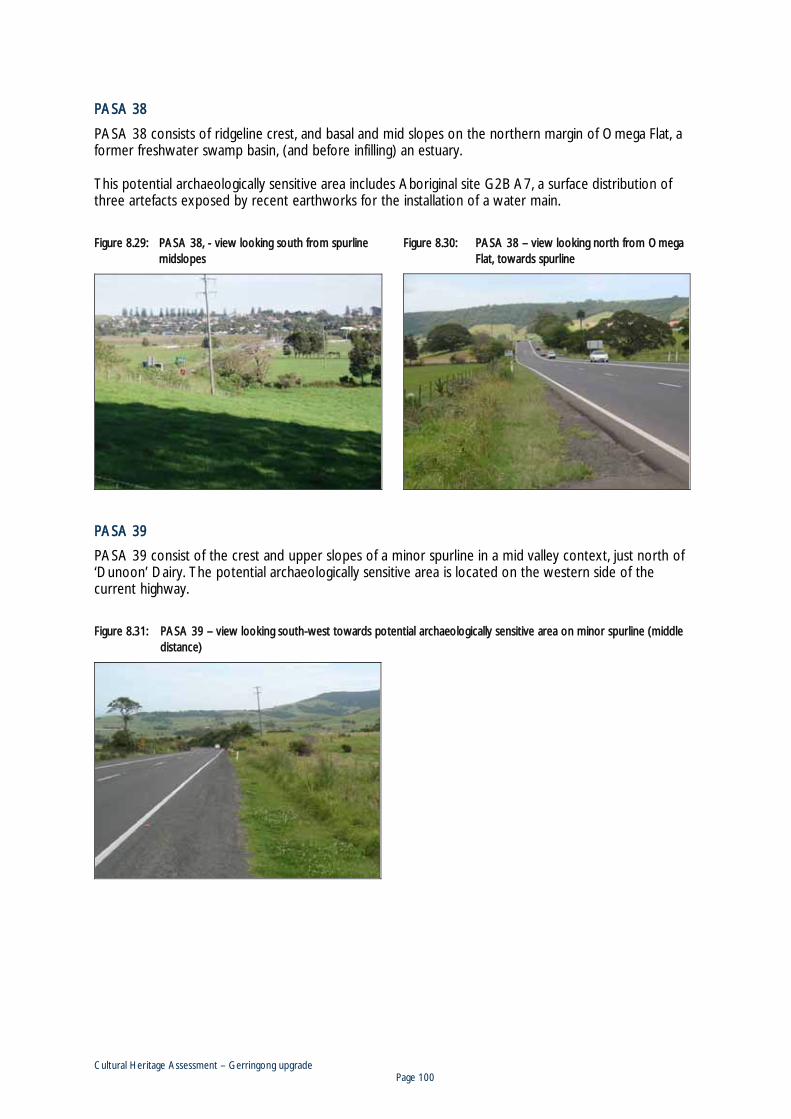
Cultural Heritage Assessment – Gerringong upgrade Page 100
PPASA 38
PASA 38 consists of ridgeline crest, and basal and mid slopes on the northern margin of Omega Flat, a former freshwater swamp basin, (and before infilling) an estuary. This potential archaeologically sensitive area includes Aboriginal site G2B A7, a surface distribution of three artefacts exposed by recent earthworks for the installation of a water main.
Figure 8.29: PASA 38, - view looking south from spurline midslopes
Figure 8.30: PASA 38 – view looking north from Omega Flat, towards spurline
PASA 39
PASA 39 consist of the crest and upper slopes of a minor spurline in a mid valley context, just north of ‘Dunoon’ Dairy. The potential archaeologically sensitive area is located on the western side of the current highway.
Figure 8.31: PASA 39 – view looking south-west towards potential archaeologically sensitive area on minor spurline (middle distance)
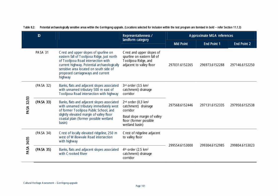
Cultural Heritage Assessment – Gerringong upgrade Page 101
TTable 8.2: Potential archaeologically sensitive areas within the Gerringong upgrade. (Locations selected for inclusion within the test program are itemised in bold – refer Section 11.1.3)
ID Location / landform Representativeness / landform category
Approximate MGA references
Mid Point End Point 1 End Point 2
PASA 31 Crest and upper slopes of spurline on eastern fall of Toolijooa Ridge, just north of Toolijooa Road intersection with current highway. Potential archaeologically sensitive area located on south side of proposed carriageways and current highway
Crest and upper slopes of spurline on eastern fall of Toolijooa Ridge, and adjacent to valley floor 297031.6152265 296973.6152288 297146.6152250
PASA
32/
33
(PASA 32) Banks, flats and adjacent slopes associated with unnamed tributary 500 m east of Toolijooa Road intersection with highway
3rd order (3.5 km2 catchment) drainage corridor
297568.6152446 297131.6152335 297950.6152538 (PASA 33) Banks, flats and adjacent slopes associated
with unnamed tributary immediately west of former Toolijooa Public School, and slightly elevated margin of valley floor coastal plain (former possible wetland basin)
2nd order (0.3 km2 catchment) drainage corridor
Basal slope margin of valley floor (former possible wetland basin)
PASA
34/
35
(PASA 34) Crest of locally elevated ridgeline, 250 m west of Willowvale Road intersection with highway
Crest of ridgeline adjacent to valley floor
299554.6153000 299304.6152985 299804.6153023 (PASA 35) Banks, flats and adjacent slopes associated
with Crooked River 4th order (2.5 km2 catchment) drainage corridor

Cultural Heritage Assessment – Gerringong upgrade Page 102
IID Location / landform Representativeness / landform category
Approximate MGA references
Mid Point End Point 1 End Point 2
PASA 36 Banks, flats and adjacent slopes associated with unnamed tributary crossing 500 m south of Sims Road intersection with highway. Potential archaeologically sensitive area located on western side of current highway
3rd order (1.5 km2 catchment) drainage corridor 300310.6153365 300250.6153265 300380.6153492
PASA 37 Basal slopes on southern margin of former Omega swamp basin
Basal slopes forming margin of both a former wetland basin and former estuary
300827.6154335 300750.6154212 300873.6154485
PASA 38 Ridgeline crest, and basal and mid slopes on northern margin of former Omega Flat swamp basin
Slopes of ridgeline adjacent to valley floor
Basal slopes forming margin of both a former wetland basin and former estuary
301250.6155750 301223.6155480 301381.6155923
PASA 39 Crest and upper slopes of a spurline just north of ‘Dunoon’ Dairy. Potential archaeologically sensitive area is located on west side of the current highway
Crest of spurline in mid valley context
301553.6156465 301508.6156335 301630.6156546

Cultural Heritage Assessment – Gerringong upgrade Page 103
FFigure 8.32: Aboriginal archaeological sites and potential archaeologically sensitive areas within the Gerringong upgrade (basemap consists of extracts from Gerroa and Kiama 1:25,000 topographic maps Second Editions L&PI)

Cultural Heritage Assessment – Gerringong upgrade Page 104
88.3 Aboriginal cultural value recordings
A comprehensive review of Aboriginal cultural values within the Southern Illawarra coastal hinterland, including the proposal study area has been compiled in a separate report (Navin Officer Heritage Consultants 2009a) and the reader is directed to this document for regional and more general information. Outside of archaeological recordings, and of generalised or regional values as previously documented (Navin Officer Heritage Consultants 2009a), Aboriginal stakeholders were able to identify site-specific cultural values within the study area with regard to mature fig trees.
8.3.1 Mature fig trees
All Aboriginal stakeholders who actively participated in the consultation program stated or concurred with a view that large and mature fig trees within the Illawarra were of high Aboriginal cultural value. The reasons for, and justification of this value varied across the different stakeholders. The validity of some justifications was disputed by varying stakeholders, and in other cases the informant’s right to speak for, or on the issue was also debated. In summary some of the stated reasons for the significance of the trees are: The well developed buttresses of the mature trees were used by Aboriginal people as shelter and
weather breaks, and often therefore used as camp sites. This is a practise remembered to occur well into the twentieth century.
Fig trees were a good source of food, including figs in season, and the animals that lived in them (possum, fruit bats).
The trees are associated with the spirit of the Yaroma. The Yaroma is a creature resembling a man but of greater size and strength, with longer teeth and hair all over their body. The Yaroma is described as a strong and dangerous creature that may be concealed within a fig tree and which may ambush unsuspecting passersby. For ethnographic accounts of the Yaroma see R.H. Mathews (1904:361; 1907:26), A. Mackenzie (1874:250-251), and J. Mathews (1994:132-133). In some cases, marks evident in the tree bark are explained as the result of Yaromas sharpening their long teeth.
Mature fig trees are associated with birthing and women’s lore (not described here due to cultural sensitivity). In some examples, notches were made along limbs to signify births into a tribe or family group.
There are 11 large and mature fig trees within or near to the proposal study area (trees MFT1 to MFT11), situated in five grouped or single incidences. Refer Table 8.3. These are: 1) A large fig tree (MFT1) immediately west of the former Omega Public School building,
approximately 40 m east of the current highway at upgrade chainage 500. The school building is historical site G2B H40.
2) A group of five large fig trees situated around the Renfrew Park homestead between chainages 1490 and 1700. The homestead and grounds is historical site G2B H38. Two trees are situated on the western side of the highway, south of Rose Valley Road, 45 m and 85 m from the current carriageway (MFT2 and MFT3 respectively). Two trees occur close to the highway on its eastern side. One tree is located on the edge of the highway cutting, at the south western corner of the homestead front enclosure (MFT4), the other is on the northern bank of a drainage channel, 140 m south of the homestead and 30 m east of the current highway (MFT5).
3) Two large fig trees (MFT6 and MFT7) situated on the banks of the Crooked River, approximately 85 m south of the current highway at chainage 4750.

Cultural Heritage Assessment – Gerringong upgrade Page 105
4) Two large fig trees (MFT8 and MFT9), are associated with the site of the original Homeleigh homestead (historical site G2B H42), approximately 75 m east of the current highway at chainage 5520.
5) Two large fig trees (MFT10 and MFT11), are associated with the site of a former Berry Estate tenant farm (historical site G2B H31), located approximately 70 m west of the current highway between approximate chainages 7350 and 7450.
Of these examples, the trees with greatest potential to be impacted by the planned upgrade are in the Renfrew Park grouping (MFT2, MFT3, MFT4 and MFT5). For all of these trees, a case can be made for either a European planted origin, or natural propagation following partial or full European vegetation clearance. This is based on an often close association with a homestead, and/or the low and spreading structure of the trees which is indicative of a non epiphytic origin, and subsequent growth without the competition of an adjacent or competing forest canopy. Some Aboriginal stakeholders dispute this interpretation and state their belief that the trees date prior to European occupation, while others point out that the trees were used by Aboriginal people well into the twentieth century, and their significance in Aboriginal lore is undiminished by an historical age or European origin.
FFigure 8.33: A large fig tree (MFT1) located just west of the fformer Omega Pubic School building (historical site G2B H40)
Figure 8.34: Two large fig trees (MFT2 and MFT3) situated opposite the Renfrew Park homestead (historical site G2B H38) on the west side of the current highway

Cultural Heritage Assessment – Gerringong upgrade Page 106
FFigure 8.35: The last remaining of two original fig trees (MFT4), planted at the front corners of the Renfrew Park homestead garden (historical site G2B H38), situated on the edge of the current highway cutting
FFigure 8.36: A large fig tree (MFT5) located on the northern bank of a drainage channel, situated downslope of the Renfrew Park homestead (historical site G2B H38)
Figure 8.37: Two large fig trees (MFT6 and MFT7) located on the banks of the Crooked River, south of the current highway
Figure 8.38: One of two large fig trees (MFT8) associated with the original Homeleigh homestead, a former Berry Estate tenant farm, historical site G2B H42

Cultural Heritage Assessment – Gerringong upgrade Page 107
FFigure 8.39: One of two mature fig trees (MFT9) associated with a former Berry Estate tenant farm, historical site G2B H31, north-west of the Toolijooa Road intersection
Figure 8.40: Detail of buttresses on one of two trees (MFT10) at a former Berry Estate tenant farm, historical site G2B H31 (G2B H31), north-west of the Toolijooa Road intersection
Table 8.3: Mature fig trees within or near to the study area
ID Location // ggroup Approximate MGA reference*
MFT1 Former Omega Public School 301740.6156512
MFT2
Renfrew Park
301236.6155646
MFT3 301193.6155694
MFT4 301295.6155616
MFT5 301298.6155478
MFT6 Crooked River
299759.6152892
MFT7 299762.6152846 MFT8
Former Homeleigh homestead 299072.6152790
MFT9 299057.6152780
MFT10 Former Berry Estate tenant farm homestead
297222.6152427 MFT11 297197.6152401
* AMG references generated off-site using Google Earth program

Cultural Heritage Assessment – Gerringong upgrade Page 108
88.4 Non-Aboriginal sites
8.4.1 Site recordings
G2B H31 Site of Harding Family Berry Estate tenant farm homestead
Map reference 297193.6152429 (MGA)
Lot 53 DP843071
This recording consists of the site of a former Berry Estate tenant farm. It is situated adjacent to the northern bank of an unnamed tributary of Crooked River. The site is marked by a single standing outbuilding (open sided, with two horse stalls), a number of remnant concrete floors (probably the remains of dairy infrastructure), two large mature Ficus trees, and potentially a range of associated archaeological remains. An early 1890s map entitled ‘Part of the Berry Estates, Parishes of Broughton and Coolangatta, County of Camden’ (see Figure 7.12) indicates that a group of farm buildings, presumably including a residence, was present at this site at that time, and was part of a tenant farm of 105 acres, held by a ‘Mrs Harding’ (Graham 1998). The 1931 Nowra 1:63360 topographic map indicates that at least one building is still present, and the 1980 Gerroa second edition 1:25,000 topographic map indicates a group of four buildings. The buildings are absent from the third edition, however, indicating their demolition, sometime between 1980 and 2005. The southern margin of the canopy of one of the ficus trees at this site is situated around 10 m north of planned upgrade earthworks
Figure 8.41: Large southern fig tree at G2B H31
Figure 8.42: Large northern fig tree at G2B H31, looking north-west

Cultural Heritage Assessment – Gerringong upgrade Page 109
FFigure 8.43: G2B H31 – Former concrete floor
Figure 8.44: Single remaining structure at G2B H31
Figure 8.45: Detail of the two horse stalls and feed bins within the one remaining building at G2B H31
Figure 8.46: Graffiti on internal walls of remaining building at G2B H31

Cultural Heritage Assessment – Gerringong upgrade Page 110
FFigure 8.47: Extract from 1958 aerial photograph showing G2B H31 building configuration at that time (NSW 694-5064 SHI Dapto-Ulladulla Run GK8 9/7/58)
G2B H32 Site of Berry Estate Pavilion and former Toolijooa Public School
Map reference 297869.6152456 (MGA)
Lot 12 DP1054598; 233 Princes Highway, Gerringong
This site consists of the former Toolijooa Public School teacher’s residence and associated grounds. The property is now a private residence. The original weatherboard residential cottage survives in a modified condition. Despite the construction of unsympathetic extensions – on the western side (pre 1958), and northern side (1960s), the original and overall nineteenth century form of the cottage, including front veranda, remains evident on the southern and eastern aspects. Many doors and sash windows appear to be original. The cottage has a high pitched hipped roof now clad with tiles, as are the verandas. Wooden shingles were noted to be still present under corrugated iron when the roof was replaced in 1981. The cottage is aligned north-south and faces east. This means that the cottage is end on to the highway. This could potentially be explained if, at the time of construction, the main road was aligned differently and along the eastern side of the building. This would make the building consistent with the contemporary norm for residential buildings to face the main road. This possibility is suggested by the configuration of roads shown on the 1866 County of Camden map (see Figure 7.8 and Figure 7.9). This map shows a north-west – south-east aligned road, together with another, extending at a right angle, in a north-easterly direction.

Cultural Heritage Assessment – Gerringong upgrade Page 111
The surrounding grounds support a number of established trees and garden beds. Some mature, and original, tree plantings have been removed, including a pine tree at the north-western end of the property and a number of coral trees (Graham no date). The current owners, Roger and Pauline Graham report that considerable historical archaeological material has been encountered during gardening and other excavations ‘anywhere we dug in the yard’. This has included coins, bottles, ceramic, horse shoes, school slates and ink wells (see Figure 8.55 to Figure 8.57). It was noted that when the stump of the pine at the north-western end of the property was removed in 1976, ‘a kitchen ash-heap, with many hand-blown bottles still unbroken’ was revealed. Based on tree rings the tree had been planted around 1900. Aboriginal artefacts have also been encountered (see Section 8.2) (Graham no date).
HHistorical outline
The following information has been variously compiled from Graham (no date), Bayley (1975), Fletcher and Burnswoods (1983), and the Draft Kiama Heritage Inventory. The first European structure built at this site was a weatherboard pavilion built by Alexander Berry for the fourth annual show of the Shoalhaven Estate Agricultural Association in February 1867 (Bayley 1975:59). The pavilion measured 50 x 22 feet and was constructed on stone foundations and had a shingle roof. The building was situated to the south of the surviving residence, and was aligned east-west, but with an entrance at its eastern end (see Figure 8.48 to Figure 8.50). The eastern doorway supports the hypothesis that the original road at the site ran to the east of the building. The pavilion became a school classroom from January 1871 when an application to Council of Education to establish a public school on the site was successful. Alexander Berry agreed to provide on lease, at a nominal rental, the schoolroom and a teachers residence. By the early twentieth century the roofs of both the pavilion / schoolroom and the residence had been replaced with corrugated iron (see Figure 8.49). In 1893 the school and grounds were purchased from the Trustees of the Berry Estate for £709. School enrolment was greatly reduced about 1911, possibly due to improvements in the road link to Gerringong. Insufficient attendance forced the school to close for a short period in 1918, and then again from December 1921 till March 1924. The school finally closed in December 1951. In 1953, the school building (and former pavilion) was dismantled and reassembled at the Gerringong School. Several changes to the structure of the building probably occurred during this re-build, including the change from a hipped to a gable roof, and additional side wall windows. The teacher’s residence remained on site and was sold along with the four acres of school grounds in 1957. The Gerringong School closed in 1994, and the repositioned schoolhouse / pavilion was then purchased by Robert and Christine Sloan and transported for a second time to its current location on the corner of Belinda Street and Victoria Street, Gerringong.

Cultural Heritage Assessment – Gerringong upgrade Page 112
FFigure 8.48: View of the Toolijooa Public School, looking south-west, probably in the late 1800s. Note separate kitchen building behind residence
Source: Wollongong City Library, Illawarra Images: P02\P02852, Neg.No. FM2/206/6/33A
Figure 8.49: View of the Toolijooa Public School, looking south-west, taken between 1915 and 1920 during the residence of teachers Mr and Mrs Tuckwell. Note fences are now two rail and the shingle roofs have been replaced with iron.
Source: Photo donated by Mrs Aldom and in collection of current property owners Mr and Mrs Graham

Cultural Heritage Assessment – Gerringong upgrade Page 113
FFigure 8.50 and Figure 8.51: Photos of the pavilion / schoolhouse and teacher’s residence taken between 1915 and 1920 during the residence of teachers Mr and Mrs Tuckwell
Source: Donated by Mrs Aldom and in collection of current property owners Mr and Mrs Graham)
Figure 8.52: G2B H32 – General view of former teachers residence, looking south-west
Figure 8.53: General view of south-eastern corner of former teachers residence
Figure 8.54: General view of reworked pavilion / schoolroom building which originally functioned as the Berry Estate exhibition pavilion and later as the Toolijooa Public Schoolhouse
Figure 8.55: G2B H32 – A square sided nineteenth century bottle recovered from the Toolijooa school site by the current owners (scale in 5 mm increments)

Cultural Heritage Assessment – Gerringong upgrade Page 114
FFigure 8.56: G2B H32 – A sample of glass and ceramic archaeological artefacts recovered ffrom the Toolijooa school site by the current owners (scale in 5 mm increments)
FFigure 8.57: G2B H32 – A sample of metal and school related archaeological artefacts recovered from tthe Toolijooa school site by the current owners (scale in 5 mm increments)
G2B H33 1990s highway remnant
Map reference Western end: 298478.6152618 Eastern end: 298758.6152765 (MGA)
This recording consists of a remnant curved section of the Princes Highway, approximately 200 m long, located on the south-west facing slopes of the ridge climb / descent situated one kilometre west of Gerringong. The road portion has been constructed on both fill and well benched slopes and includes two pipe culverts. The carriageway has a bitumen surface and provides a single dual lane. A series of four pine trees have been planted along the southern side of the road at its uphill end. The remnant remains open to the current highway at its western end and provides access to Strathford, an adjacent property. The highway easement for this portion of highway became established in the late nineteenth century and originally contained a roadway with three straight sections separated by bends (refer Figure 7.12). The bends were later smoothed to curves. The remnant road portion was bypassed by the construction of the current, straighter and wider carriageway immediately to the south. In this area the current highway incorporates the ends of both north and southbound climbing lanes. A review of aerial photography and topographic mapping indicates that the remnant road portion was bypassed sometime between 1992 and 2005.
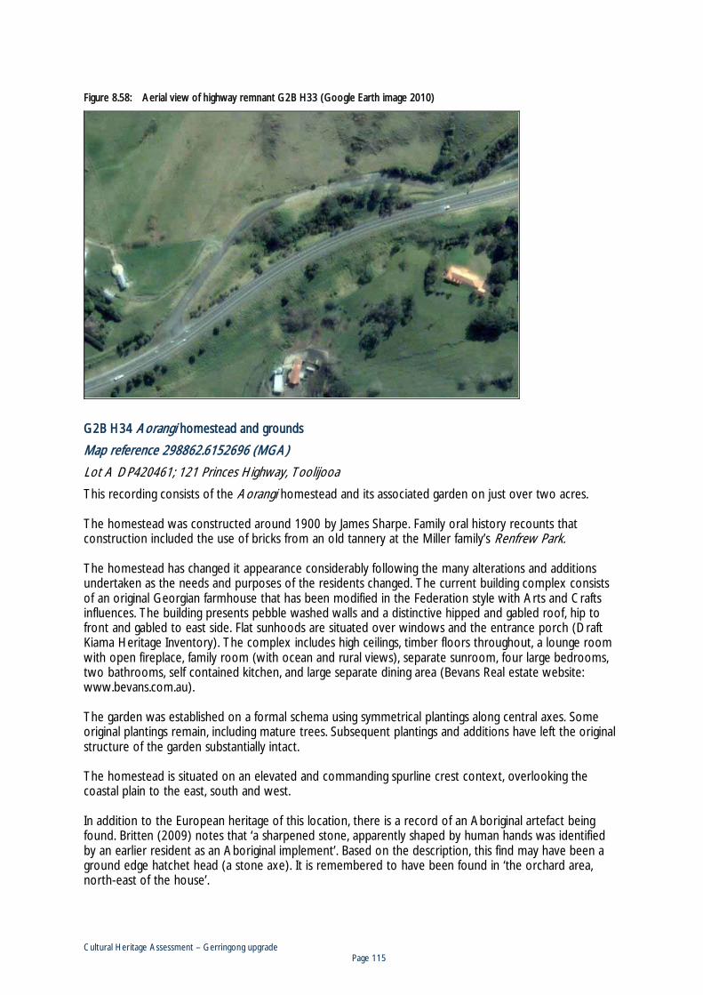
Cultural Heritage Assessment – Gerringong upgrade Page 115
FFigure 8.58: Aerial view of highway remnant G2B H33 (Google Earth image 2010)
G2B H34 Aorangi homestead and grounds
Map reference 298862.6152696 (MGA)
Lot A DP420461; 121 Princes Highway, Toolijooa
This recording consists of the Aorangi homestead and its associated garden on just over two acres. The homestead was constructed around 1900 by James Sharpe. Family oral history recounts that construction included the use of bricks from an old tannery at the Miller family’s Renfrew Park. The homestead has changed it appearance considerably following the many alterations and additions undertaken as the needs and purposes of the residents changed. The current building complex consists of an original Georgian farmhouse that has been modified in the Federation style with Arts and Crafts influences. The building presents pebble washed walls and a distinctive hipped and gabled roof, hip to front and gabled to east side. Flat sunhoods are situated over windows and the entrance porch (Draft Kiama Heritage Inventory). The complex includes high ceilings, timber floors throughout, a lounge room with open fireplace, family room (with ocean and rural views), separate sunroom, four large bedrooms, two bathrooms, self contained kitchen, and large separate dining area (Bevans Real estate website: www.bevans.com.au). The garden was established on a formal schema using symmetrical plantings along central axes. Some original plantings remain, including mature trees. Subsequent plantings and additions have left the original structure of the garden substantially intact. The homestead is situated on an elevated and commanding spurline crest context, overlooking the coastal plain to the east, south and west. In addition to the European heritage of this location, there is a record of an Aboriginal artefact being found. Britten (2009) notes that ‘a sharpened stone, apparently shaped by human hands was identified by an earlier resident as an Aboriginal implement’. Based on the description, this find may have been a ground edge hatchet head (a stone axe). It is remembered to have been found in ‘the orchard area, north-east of the house’.

Cultural Heritage Assessment – Gerringong upgrade Page 116
HHistorical outline
The following historical outline is based largely on Britten (2009), historical notes kindly provided to AECOM by the author.
The Sharpe family and subsequent ownership
Aorangi was built by James Wallace Sharpe as his family home in around 1900. The household consisted of his wife Mary Jane (née Nelson) and their 10 children. James was born on 11 September 1853 in the district of Kiama, the second son, and first Australian born child of Neil Sharp and Agnes, née Wallace. In 1882, James married Mary Jane Nelson, daughter of another local Gerringong family. James died at Aorangi on 21 September 1930. Mary died two years later at the home of her daughter Mrs R. M. Miller. An early 1890s map of the Berry Estate identifies a J. Sharpe as a tenant farmer on two blocks, of 151 and 72 acres, situated immediately to the west of the future Aorangi block and on either side of the highway (refer Figure 7.12). It is probable that this refers to James Sharpe and that he secured the Aorangi block at the time of its auction by the estate Trustees, or shortly after from a new owner. The map reveals that there were no homestead or farm buildings on the future Aorangi block (of 60 acres), which was held at this time by a Charles Jorden (Figure 7.12). Five of James’ six sons took up dairying and a large landholding of Sharpe-owned property eventually encircled the family home Aorangi on three sides. By the time James established the Aorangi homestead, he was financially established, and a public figure in the local area with, business and social connections reaching beyond the district. His status influencedthe design and the use of his house. James and his family were to become key players in the dairying industry, adopting new technologies and methods on a major district holding. James installed the first steam-driven boiler and cream separator in the district. The property had a large herd of short-horn cattle and exhibited annually at the RAS ‘Easter’ show. The family also supported the local agricultural shows, where Mary Jane judged local produce and cookery. The following is a list of James Sharpe’s known involvements: Alderman on Gerringong Council, 1891 – 1930, including periods of service as mayor. Director of the Gerringong Co-operative Dairy Society – Chairman 1908-1930. Chairman for 30 years of the Board of Dairy Farmers, Harris Street Sydney. Director, Pastures Protection Board. President of the Gerringong Rifle Club. Vice-President of the Milking Short-Horn Society. Life Deacon of the Gerringong Congregational Church.
James’s name was inscribed on the foundation stone of the Gerringong RSL Hall and the Kiama Hospital. Published histories and press clippings indicate that Aorangi was the hub of Sharpe family life and the scene of entertainments for the family and the broader social life of Gerringong. The last of the Sharpes to live at Aorangi were James’s youngest son Ronald David Milton Sharpe and his wife, Una, née MacDowell. Following Ronald’s death in 1946, aged 47, the farm was managed on Una’s behalf by Ronald’s brother in law Hedley Miller. Mrs Una Sharpe sold to Beth and Antony Barton Britten in 1960. The Aorangi farm was subdivided in 1960, leaving the homestead on a lot, just over two acres in size.

Cultural Heritage Assessment – Gerringong upgrade Page 117
TThe buildings
When first built, the house had a bay window and a front veranda roofed with bull-nosed iron. The front gable was edged with a decorative bargeboard and the veranda posts trimmed by iron-lace cornices. All of these features were replaced over time with the current arrangement in which the chief visual feature of the façade is the outer portico (Figure 8.60). The bay window was removed and the veranda absorbed into an extension of the room that lay behind it. At the rear of the house, a separate kitchen building, connected to the main house by verandas, was later incorporated into the house to form a double drawing room linked by double-doors to one of the original house rooms. Presumably at this time, a new kitchen was established within an enclosed veranda on the eastern rear of the house (Figure 8.62). Verandas around the house have been progressively enclosed. On the western side of the house, a self-contained ‘flat’ with bathroom and kitchen was created in the 1950s, incorporating some of the rooms of the original dwelling as well as part of the enclosed verandas on that side of the house. Internally, the original lay-out of the house remains discernible as a series of rooms opening from a central hallway (Figure 8.64). Much of the original interior architectural detail remains unchanged (such as skirtings, cornices, doors). At the rear of the central hall an exterior door of formal design was presumably the original front door to the house. A group of vertical timber slab sheds situated at the rear of the house, are presumed to have been moved from earlier homestead or farm locations. A garage to the east of the house was added to the property in 1921. Remains of a square brick tank, which may date from the original construction phase are situated behind the sheds. The structure was largely destroyed by a lightning strike in March 2007. An ornamental ‘summer-house’ in the south-western area of the grounds post-dates Sharpe occupation of the property, as does a bird house on the eastern front lawn. According to family oral history, in his later years, James Sharpe built a smaller house in the north-eastern corner of the Aorangi property as a residence for himself and his wife. Mary continued to occupy this dwelling after James died here in 1930. After her death two years later, the ‘dower house’ was dismantled and moved to Jamberoo, where it remains beside the Presbyterian Church. Remnants of the footings of this house were still evident in the 1960s, and bulbs from the cottage garden still flower in season.
The garden and grounds
The original design of the garden was based on simple geometric lines and subsequent occupants and owners have remained faithful to this original schema. The layout was based on a central driveway axis, with gardens and grounds arranged symmetrically to either side and defined by hedges of red flowering Tacoma. Plantings on either side of the driveway reinforce the sense of symmetry, beginning with a pair of now mature bunya pine-trees situated on either side of the gate-posts. Beyond the gates, are a pair of jacarandas and camphor laurels, the latter were planted by William (Bill) Sharpe, James’s fourth son. A circular lawn at the front of the house, together with a crescent shaped bed of saxifrage (now bergenia) plantings are remembered to be early features of the garden. An orchard area lies to the east of the main garden, enclosed by tacoma hedge on three sides. A feature of the present garden is the variety of mature trees, in particular, the bunya pines at the front of the property, a stand of fig trees at the south western corner, and a maturing English oak planted by Cyril Gardner (grandfather to Jane Britten) during the 1960s.

Cultural Heritage Assessment – Gerringong upgrade Page 118
FFigure 8.59: G2B H34 - Entrance way to Aorangi homestead, looking south
Figure 8.60: G2B H34 – Aerial view of Aorangi and grounds in 1992
Source: Waterfall to Nowra 176-186, ACD14 – 180, 8/11/92
Figure 8.61: G2B H34 - View of front (northern aspect) of Aorangi homestead, looking south
Source: http://www.allhomes.com.au
Figure 8.62: G2B H34 – View of eastern aspect of homestead, looking west, note numerous additions and enclosed verandas
Figure 8.63: G2B H34 - View looking south across the Aorangi grounds from hill on opposite side of hhighway, note prominent location and mature trees

Cultural Heritage Assessment – Gerringong upgrade Page 119
FFigure 8.64: G2B H34 interior view of hallway
Source: www.allhomes.com.au
Figure 8.65: G2B H34 interior view of lounge room
Source: www.allhomes.com.au
G2B H35 disused vehicle dump
Map Reference 300154.6153077 (MGA)
Lot2 DP829039
This recording consists of a group of disused vehicles and associated mechanical and related debris, all in a poor condition and partly overgrown within a bamboo thicket. These items are situated on the eastern side of the current highway, approximately 150 m north of the Belinda Street intersection at Gerringong and appear to occupy the backyard of a residence situated further to the south. Some of the items may be situated within, or partly within the current highway easement. The assemblage as a whole is suggestive of a former depot for heavy vehicle and machinery. Amongst the vehicles noted were: A Commer tip truck, which has the appearance of the VA or VC Series which were manufactured
between 1963 and 1967 (Figure 8.66 and Figure 8.67). A plastic Tiki has been stock on the dash board of the truck’s cabin. Within the cabin a plate provides the following information:
J(?) SANK(?)E(?)T(?) & SONS LTD
WELLINGTON SHROPSHIRE
Model QX Serial No. / 5(?)98(?)66
The plate identification of a QX model is difficult to place within the documented historical sequence of Commer truck models and deserves further research to clarify the status and history of the vehicle (http://www.commer.org.nz/Commer_Connections/VA.html).
A truck without clear brand or model identification on its front, also apparently dating from the
1960s, with the following chromed plate on the front of the radiator (Figure 8.68 and Figure 8.69):
Dept. of Government Transport
Constructed by the Apprentices of
Gordon Ave. Workshops 23-2-66

Cultural Heritage Assessment – Gerringong upgrade Page 120
The reference to the Gordon Avenue workshops relates to a bus (and formerly also tram) depot at Hamilton, Newcastle, NSW.
Three other truck / car bodies dating perhaps around the 1950s (Figure 8.70). A caterpillar tread dozer(?) (Figure 8.71). A Jayco trailer-caravan. A full sized caravan. A box trailer. A variety of fuel drums, including a large cylindrical metal tank. Other scrap metal, wood and corrugated iron sheeting.
FFigure 8.66: G2B H35 – Disused 1960s COMMER tip up truck
Figure 8.67: G2B H35 – Detail of cabin of disused 1960s COMMER tip up truck
Figure 8.68: G2B H35 - Front view of truck with inscribed plate on radiator grill
Figure 8.69: G2B H35 – Detail of inscribed plate on truck shown in preceding figure

Cultural Heritage Assessment – Gerringong upgrade Page 121
FFigure 8.70: G2B H35 – One of three other truck / car bodies in poor condition
Figure 8.71: G2B H35 – Remains of a dozer(?) with caterpillar tread
G2B H36 agricultural dry stone walls
Map references Eastern point of wall1: 300720.6154154 Eastern end of wall 2: 300733.6154175 (MGA)
Lot2 DP6032139; 310 Princes Highway, Gerringong.
This site consist of a remnant of an early dry stone agricultural wall which is now situated within the front yard and garden of a recent residential lot. More recent dry stone walling, probably constructed as part of the associated residential buildings, occur along the northern boundary of the lot, together with the recent driveway (refer Figure 8.73). The early wall remnant is approximately 50 m long and extends (with one gap) from the southern side of a modern metal clad building towards the eastern boundary of the lot, where it ends at the boundary of the current crown land Princes Highway easement. The fence is around one metre to 1.1 m high and has been constructed with sloping sides to form a base approximately one metre wide (Figure 8.74 to Figure 8.76). Construction of this wall probably followed the ‘double-dyke’ method where two inward leaning walls are in-filled with smaller stones and a stone capping is placed on the walls apex. The orientation of the wall (looking west) is 267 degrees magnetic. The other examples of stone walling at this property are clearly more recent, based on: The lack of advanced patina on many of the rock used. The different construction, using narrower and near vertical walls. The close relationship of the walls with modern features such as the driveway and the amended
northern boundary of the subdivision allotment (Figure 8.77 and Figure 8.78). The wall approximates the southern boundary of a small town portion No. 60 and may relate to the enclosure of this land. However, reference to the 1970 Kiama first Edition 1:25,00 topographic map reveals that wall is similarly aligned with a longer section of stone wall 600 m to the west, and 300 m south of the Alne Bank homestead (Figure 8.72). This suggests that both relate to a nineteenth century determination of the southern boundaries of portions 171 and 172, Parish of Broughton, (originally belonging to the Renfrew Park and Alne Bank properties respectively). The walls may originally have been continuous, or alternatively, may always have been distinct, and related to the separate ownership of these two properties, or to the small town portion 60.

Cultural Heritage Assessment – Gerringong upgrade Page 122
FFigure 8.72: Location of G2B H36 relative to portion boundaries and another wall remnant related to the Agnes Banks property (left: extract from Kiama First Edition 1:25,00 topographic map CMA 1970, right: extract from fourth edition map of Parish of Broughton 1878)
Figure 8.73: G2B H36 – Location of early stone wall (yellow) relative to modern residential buildings and more recent northern boundary stone wall (red)
Google Earth image 2010
Figure 8.74: G2B H36 – General view of early stone wall ssituated south of the modern block boundary, looking north-west

Cultural Heritage Assessment – Gerringong upgrade Page 123
FFigure 8.75: G2B H36 – Detail of eastern end and south face of early stone wall (scale is extended 95cm)
Figure 8.76: G2B H36 – Detail of eastern end and north face oof early stone wall (scale is extended one metre)
Figure 8.77: G2B H36 – General view of more recent stone wall along northern boundary of modern lot
Figure 8.78: G2B H36 – Detail of south face of more recent stone wall (scale is extended one metre)
G2B H37 site of Omega Stationmaster’s residence
Map reference 301179.6154916 (MGA)
Crown land easement
This recording consists of a remnant potential archaeological deposit at the location of the former Omega Stationmasters residence. The potential archaeological deposit is located on the south side of the intersection of Fern Street with the current Princes Highway. Remnants of the potential archaeological deposit may occur within a triangular section of ground bordered in the south by the Ooaree Creek drainage channel, in the west by the current Princes Highway, and on the east by Fern Street and South Coast Railway Line easement. A photo of the building, taken in 1938 just after the completion of the Princes Highway bypass of Gerringong (‘the Omega Deviation’), reveals a weatherboard cottage facing the rail easement with skillion roofed backrooms. A number of sheds at the rear of the property are the closest structures to the highway. Despite an absence of surface evidence for these former structures, and a substantial degree of modern ground disturbance, there remains some potential for subsurface archaeological material to remain below the ground.
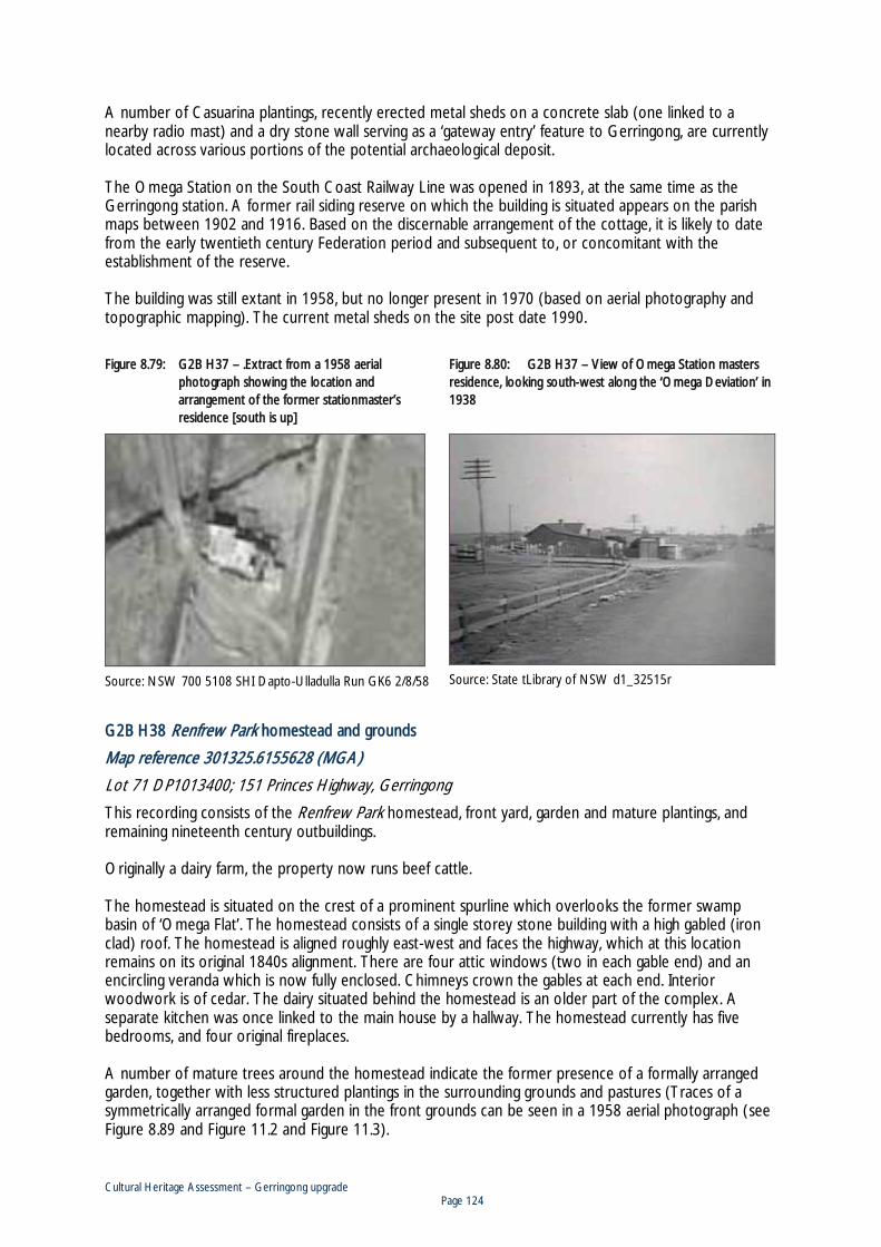
Cultural Heritage Assessment – Gerringong upgrade Page 124
A number of Casuarina plantings, recently erected metal sheds on a concrete slab (one linked to a nearby radio mast) and a dry stone wall serving as a ‘gateway entry’ feature to Gerringong, are currently located across various portions of the potential archaeological deposit. The Omega Station on the South Coast Railway Line was opened in 1893, at the same time as the Gerringong station. A former rail siding reserve on which the building is situated appears on the parish maps between 1902 and 1916. Based on the discernable arrangement of the cottage, it is likely to date from the early twentieth century Federation period and subsequent to, or concomitant with the establishment of the reserve. The building was still extant in 1958, but no longer present in 1970 (based on aerial photography and topographic mapping). The current metal sheds on the site post date 1990.
FFigure 8.79: G2B H37 – .Extract from a 1958 aerial photograph showing the location and arrangement of the former stationmaster’s residence [south is up]
Source: NSW 700 5108 SHI Dapto-Ulladulla Run GK6 2/8/58
FFigure 8.80: G2B H37 – View of Omega Station masters residence, looking south-west along the ‘Omega Deviation’ in 1938
Source: State tLibrary of NSW d1_32515r
GG2B H38 Renfrew Park homestead and grounds
Map reference 301325.6155628 (MGA)
Lot 71 DP1013400; 151 Princes Highway, Gerringong
This recording consists of the Renfrew Park homestead, front yard, garden and mature plantings, and remaining nineteenth century outbuildings. Originally a dairy farm, the property now runs beef cattle. The homestead is situated on the crest of a prominent spurline which overlooks the former swamp basin of ‘Omega Flat’. The homestead consists of a single storey stone building with a high gabled (iron clad) roof. The homestead is aligned roughly east-west and faces the highway, which at this location remains on its original 1840s alignment. There are four attic windows (two in each gable end) and an encircling veranda which is now fully enclosed. Chimneys crown the gables at each end. Interior woodwork is of cedar. The dairy situated behind the homestead is an older part of the complex. A separate kitchen was once linked to the main house by a hallway. The homestead currently has five bedrooms, and four original fireplaces. A number of mature trees around the homestead indicate the former presence of a formally arranged garden, together with less structured plantings in the surrounding grounds and pastures (Traces of a symmetrically arranged formal garden in the front grounds can be seen in a 1958 aerial photograph (see Figure 8.89 and Figure 11.2 and Figure 11.3).
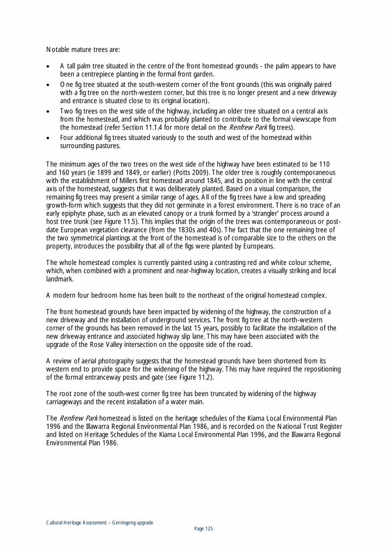
Cultural Heritage Assessment – Gerringong upgrade Page 125
Notable mature trees are: A tall palm tree situated in the centre of the front homestead grounds - the palm appears to have
been a centrepiece planting in the formal front garden. One fig tree situated at the south-western corner of the front grounds (this was originally paired
with a fig tree on the north-western corner, but this tree is no longer present and a new driveway and entrance is situated close to its original location).
Two fig trees on the west side of the highway, including an older tree situated on a central axis from the homestead, and which was probably planted to contribute to the formal viewscape from the homestead (refer Section 11.1.4 for more detail on the Renfrew Park fig trees).
Four additional fig trees situated variously to the south and west of the homestead within surrounding pastures.
The minimum ages of the two trees on the west side of the highway have been estimated to be 110 and 160 years (ie 1899 and 1849, or earlier) (Potts 2009). The older tree is roughly contemporaneous with the establishment of Millers first homestead around 1845, and its position in line with the central axis of the homestead, suggests that it was deliberately planted. Based on a visual comparison, the remaining fig trees may present a similar range of ages. All of the fig trees have a low and spreading growth-form which suggests that they did not germinate in a forest environment. There is no trace of an early epiphyte phase, such as an elevated canopy or a trunk formed by a ‘strangler’ process around a host tree trunk (see Figure 11.5). This implies that the origin of the trees was contemporaneous or post-date European vegetation clearance (from the 1830s and 40s). The fact that the one remaining tree of the two symmetrical plantings at the front of the homestead is of comparable size to the others on the property, introduces the possibility that all of the figs were planted by Europeans. The whole homestead complex is currently painted using a contrasting red and white colour scheme, which, when combined with a prominent and near-highway location, creates a visually striking and local landmark. A modern four bedroom home has been built to the northeast of the original homestead complex. The front homestead grounds have been impacted by widening of the highway, the construction of a new driveway and the installation of underground services. The front fig tree at the north-western corner of the grounds has been removed in the last 15 years, possibly to facilitate the installation of the new driveway entrance and associated highway slip lane. This may have been associated with the upgrade of the Rose Valley intersection on the opposite side of the road. A review of aerial photography suggests that the homestead grounds have been shortened from its western end to provide space for the widening of the highway. This may have required the repositioning of the formal entranceway posts and gate (see Figure 11.2). The root zone of the south-west corner fig tree has been truncated by widening of the highway carriageways and the recent installation of a water main. The Renfrew Park homestead is listed on the heritage schedules of the Kiama Local Environmental Plan 1996 and the Illawarra Regional Environmental Plan 1986, and is recorded on the National Trust Register and listed on Heritage Schedules of the Kiama Local Environmental Plan 1996, and the Illawarra Regional Environmental Plan 1986.

Cultural Heritage Assessment – Gerringong upgrade Page 126
HHistorical outline
In 1825, William Smith located and was granted 600 acres to the south of Kiama, which came to be known as ‘Smiths Swamp’. The grant was surveyed in 1826 and identified as portion 171 in the Parish of Broughton, County of Camden. The land was subsequently purchased by Lieutenant Thomas Campbell (a clerk of Alexander Berry) who then sold to Miller (http://www.smh.com.au). Smith’s original holding was purchased by Robert Miller in 1835 for five shillings an acre. The year before, Smith had arrived in Australia with his wife and six children. On arrival he was described as a carpenter (Cousins1948). Smith reportedly settled on the new estate in 1837, built a slab house in around 1845 and settled with his wife and 6 children, naming the property ‘Renfrew Park’ (www.smh.com.au, www.gerringong-gerroa.com/history-l.htm). A number of dates are reported for Miller’s completion of the current homestead adjacent to his original slab home - by 1851 (Draft Kiama Heritage Inventory), in 1862 (http://www.smh.com.au), or in 1866 (www.gerringong-gerroa.com/history-l.htm). The homestead was remodelled in 1932 resulting in the wooden verandas being replaced by brick construction. The home remained in the Miller family until the 1970s. Much of the original furniture has been transferred to other Miller families in the district (Draft Heritage inventory). In 1981, the homestead retained the original four poster bed (Anne Groston Ali 1981).
Figure 8.81: G2B H38 – .Oblique aerial view of homestead and front grounds looking south-east. Note recently constructed driveway and entrance
Source: http://www.domain.com.au
Figure 8.82: G2B H38 – Front view of homestead and disused central entrance way

Cultural Heritage Assessment – Gerringong upgrade Page 127
FFigure 8.83: G2B H38 – View looking south from modern ddriveway. Note planted fig tree at lower front corner. The pair to this tree was situated in the foreground
Figure 8.84: G2B H38 – Detail of the disused central entranceway
Figure 8.85: G2B H38 – View of northern gable, looking south-east
Figure 8.86: G2B H38 – View of enclosed veranda across front of homestead, looking south
Figure 8.87: G2B H38 – The rear of the homestead, looking west, showing outbuildings and additions
Figure 8.88: G2B H38 – The former dairy building located behind the homestead, looking south

Cultural Heritage Assessment – Gerringong upgrade Page 128
FFigure 8.89: G2B H38
Source: left: 2009 Google Earth image, right: extract from aerial photograph NSW 700-5108 SHI Dapto – Ulladulla Run GK6 2/8/-58
G2B H39 early 1940s highway remnant
Map Reference Southern end: 301312.6155708 Northern end: 301454.6156008 Mid Point: 301403.6155848 (MGA)
Lot71 DP1013400, Lot15 DP3923, Lot23 DP584907, Lot22 DP584907
This recording comprises a remnant section of the Princes Highway which was bypassed by construction of the current alignment around 1939 (refer parish maps in Figure 8.92). The remnant is slightly curved and approximately 300 m long. The southern end of the remnant joins the existing highway easement just north of the current Renfrew Park driveway entrance. The roadway consists of a single carriageway and, based on its surface appearance, appears not to have been bitumised. The roadway has been cut, up to a metre into a low gradient slope on its eastern side and benched on the opposite side. Shallow drainage ditches remain discernable on either side of the carriageway. A number of coral trees are situated on the eastern side of the road.

Cultural Heritage Assessment – Gerringong upgrade Page 129
Figure 8.90: G2B H39 - View of remnant highway, looking north along the length of alignment from its southern end
Figure 8.91: Extract from 1958 aerial photograph showing former highway alignment to right of current alignment
Source: NSW 700 5108 SHI Dapto-Ulladulla Run GK6 2/8/58

Cultural Heritage Assessment – Gerringong upgrade Page 130
FFigure 8.92: Extracts from the parish maps of Broughton, showing straightening of the highway easement, just north of Renfrew Park. The new road alignment was resumed in November 1939 (map notes 43 and 44), and the former road easement (outlined in blue), was closed and vested in the adjacent land owner in October 1943 (note 50)
5th Edition (1902, map cancelled 1916)
7th Edition (map in use between 1938 – 1959)
Cultural Heritage Assessment – Gerringong upgrade Page 131
GG2B H40 former Omega Public School
Map reference 301777.6156516 (MGA)
Lot10 DP853156; 49 Princes Highway, Gerringong.
This recording comprises the former Omega Public School building. The building now forms part of a private residence. The original building appears to have been aligned north-west – south-east, parallel to the highway, and positioned some 75 m from the highway easement, allowing for a large front play area. The building is of masonry construction with a hipped roof and a central gabled porch (Figure 8.95). Extensive additions have occurred to the building, primarily involving additions to the rear of the original. The draft Kiama Heritage Inventory notes that extensive renovations have occurred in recent years, including loss of detail from re-rendering and the installation of a concrete tile roof. Also evident is the replacement of the original nine pane sash windows along the front of the building. A review of aerial photography reveals the following former features and changes:
1958: (17 years after school closure, refer Figure 8.95). By this time the building includes a north-west – south-east aligned wing, extending from the rear side of the main schoolroom wing at its south western end. There is a chimney at the southern end this wing, and a skillion roofed room beyond that. Further research is required to determine if this is a post-school addition or part of the original school configuration, such as a teachers residence.
Two (probably thee) structures are evident in front of the main building, abutting the
southern boundary, one has a hipped roof, and another a sloping flat roof these are likely to have functioned as storage or shelter sheds, stalls for student horses, and a vehicle garage.
The yards behind the main buildings are subject to vegetable cultivation and includes
some small gardening sheds. 1975 Backyard sheds gone, whole of yards now grassed, with tree / hedge plantings
recently completed around property boundaries. 1986 A rectangular structure (perhaps an awning or landing), is situated in front of the
central gabled porch. A garage and additional rooms have been added to the rear of the building. The three front yard structures along the southern boundary remain.
1992 Subsequent to 1990 and before November 1992, the three front structures were
removed. Substantial garden planting in the front section of property facing highway. Post 1992 Erection of a metal shed in front yard, adjacent to the northern boundary.
Historical outline
The Omega school building was built as a separate entity on James Mackey Grey’s estate Omega Retreat. It was opened as ‘The Omega Retreat National School’ in November 1860. The National School system was introduced by Governor Bourke in 1848 and was modelled on an existing system operating in Ireland. It involved the appointment of patrons in each district who would then organise the local support, and supply and support the teachers. Some schools were established as model schools where some limited training of new teachers was undertaken (Cousins 1948:320).

Cultural Heritage Assessment – Gerringong upgrade Page 132
James Grey was intimately involved in local public affairs and served as Magistrate and Member of the Illawarra District Council between 1844 and 1858. His son Samuel Gray, a member of the NSW Legislative Council was instrumental in establishing the school. A notable early principal was Frank Hutchinson who was at Omega around 1862 (Draft Kiama Heritage Inventory). Together with other schools in the region previously established under the national schools system, Omega Retreat became a public school in 1866. It continued till March of 1908 when it temporarily closed, to reopen in March of 1911 as the Omega Public School. The school closed for the last time in March of 1941 (Fletcher and Burnswoods 1983).
FFigure 8.93: G2B H40 – The rear of the homestead, looking west, showing outbuildings and additions
Figure 8.94: G2B H40 – The former dairy building located behind the homestead, looking south
Figure 8.95: The Omega Public School in 1958 (Wollongong City Library W.A. Bayley Collection)

Cultural Heritage Assessment – Gerringong upgrade Page 133
GG2B H41 1940s highway remnant
Map reference North western end: 299316.6153005 South eastern end: 299526.6152902 (MGA)
Lot2 DP129977, Lot50 DP868956
This recording comprises two remnant sections of the Princes Highway which were bypassed by construction of the current straightened alignment in the early 1940s (see Figure 8.96, Figure 8.97 and Figure 8.98). The two remnants divided by the current highway extend across a combined distance of 250 m. The northern end of the alignment was situated at a bend adjacent to the ‘Hillcrest’ homestead, site of a former Berry Estate tenant farm of 69 acres held by a G. Lee (see Figure 7.12). Buildings belonging to the Crooked River Winery are now situated on this location. The roadway is evident only as micro-surface relief across the current pasture and is the only remaining feature of a number of former sequential road alignments in this area. These were more evident in 1958 and are described and traced in a number of overlays in Figure 8.96.
Figure 8.96: Extract from 1958 aerial photo showing a number of remnant highway alignments adjoining the Willowvale Road intersection, just west of the Crooked River
Source: (extract from NSW 694 - 5060 SHI Dapto-Ulladulla Run GK8 6/7/58) Note: Technically this alignment should match the property boundary evident 25 m to the left. The alignment shown is
based on a tracing of the 1866 county map and the shift to the right may be a mapping error. Despite this, the shift does provide an explanation for alignment of the modern cross street which is unusually also shifted away from the cadastral boundary

Cultural Heritage Assessment – Gerringong upgrade Page 134
FFigure 8.97: The location of remnant highway G2B H41 (shown in dashed blue outline)
Figure 8.98: Extract from Parish map of Broughton 7th Edition (in use between 1938 and 59), showing straightening of highway to the east and west of the Crooked River crossing. The western extension of Belinda Street was closed in January 1941 (note 48), and the two cut off corners on the west side were closed in 1946 and 47 (notes 58 and 59)
Note: This road portion is shown in a 1920s photograph of the Homeleigh property, (refer FFigure 7.14 in SSection 7.1.5).
G2B H42 site of original Homeleigh (Bailey Family) Berry Estate tenant farm homestead
Map reference 299047.6152825 (MGA)
Lot8 DP579406
This recording consist of the remnant plantings and archaeological remains of the original Homeleigh homestead. This was a former Berry Estate tenant farm held by the Bailey family, and subsequently purchased and operated by family members and their descendents to the present day. The site is situated on the prominent crest of a south-east facing spurline, on the south side of the current highway 550 m west of the Willowvale Road intersection. This section of the highway follows the alignment of Alexander Berry’s original private estate road (refer Figure 7.12). Based on 1920s photography (see Figure 8.105), the homestead appears to have been aligned roughly north-south with the front facing the east, presumably to take advantage of the impressive view to Gerringong from this vantage.

Cultural Heritage Assessment – Gerringong upgrade Page 135
The features of the site, based on a surface inspection consist of: 1) A low pile of debris including bricks, rock ceramic pipe and a fragment of a cast iron stove, which
are considered to be the approximate location and remains of the homestead hearth (pers. Comm. Geoff Bailey 2010) (see Figure 8.99 and Figure 8.100).
2) A square brick walled tank placed on a foundation of sandstone flagstones which may relate to an earlier and much larger structure (see Figure 8.99 and Figure 8.101).
3) A concrete floor / foundation reportedly belonging to an early cream separation room (‘creamery’), (see Figure 8.102). A small building in this location is evident on aerial photography in 1875, but absent in 1986.
4) A downslope cut and benched earth platform which is reportedly the location of a dairy (see Figure 8.103).
5) Two large fig trees situated on the lower platform. 6) The location of a former orchard, between the ‘hearth’ and the southern boundary of the highway
easement. Some fruit trees believed to be original or propagations from the original orchard trees remain around the modern house, including persimmon trees.
7) A comparatively recent round concrete water tank at the eastern end of the lower platform (see Figure 8.103).
A modern house has been constructed immediately to the east of the former homestead site and is currently occupied by Geoff Bailey. Mr Bailey states that a remembered feature of the former homestead garden and orchard were paths made of shell grit. He also notes that old bricks (of an early machine manufacture) bearing the letters DB in a rectangular frog, locally known as ‘David Berry’ bricks, are commonly found on site (see Figure 8.104). The use of letters, such as owner initials, on bricks manufactured on large estates was a common practice in the nineteenth century. Previously noted forms on the Berry Estate include the use of W and B within a heart shaped frog (for Berry and Wollstonecraft), and B within a rectangular frog with fluted edges used in a building built by David Berry in 1885 (Gemmell 1986:83). It is reasonable to conclude that the DB bricks were manufactured during David Berry’s management of the estate. The time period of manufacture can be conjectured to be between 1836 when David arrived at the estate, and sometime after 1889, the year of his death. More particularly DB bricks may have been created after Alexander’s withdrawal from the estate’s business following his wife’s death in 1845, and certainly after his death in 1873. If these chronologies are accepted, then the presence of DB bricks at the Homeleigh site suggests construction activity within a period from the middle of the nineteenth century, to around 1890.
HHistorical outline
The following has been summarised primarily from Ritchie (1988). William Bailey snr moved from the Hunter Valley in 1850, when it is thought that the family had acquired a clearing lease on the Berry Estate. William married Marey Anne in 1860, prior to her marriage Marey resided at Longbush, (south of Terragong Swamp near Kiama). The 1866-67 electoral roll lists William Bailey snr, as a resident of Kiama, and leaseholder at Gerringong. All future references to William’s residence are at Longbush. Marey died at Longbush in1874, William died a year later at his daughter’s residence at Waterloo. William and Marey’s eldest son William jnr had become a tenant farmer on the Berry Estate by 1855 (probably a clearing lease [after 1850]), It was William jnr who named the farm Homeleigh. William married Susan Lee in 1855, Kiama, and they had 10 children between 1856 and 1872, including David Francis in 1869. The 1866-67 electoral roll lists William Bailey jnr, as both a resident and leaseholder at Gerringong.

Cultural Heritage Assessment – Gerringong upgrade Page 136
The first homestead built on the site was burnt down in a disastrous fire which swept an area from Broughton Village to the sea. [It is unclear if this refers to the Gerringong fires in July 1872 or July 1883 , or to another event]. The second house on site was built of vertical slab timbers, and included four main rooms, a kitchen, and two attic rooms in a high pitched roof. It is presumably this building which is depicted in a photograph held in the Bailey family collection (Figure 8.106), (or the photograph provided the basis for this description). The house was built on tree posts which rotted at ground level as did the base plates. The poor condition of the house necessitated its demolition in 1935. William Bailey jnr was one of first Trustees appointed for the Gerringong School of Arts, and was a provisional director of the Framers Co-op at its formation (Cousins 1948). Dairy produce from Homeleigh took out prizes from the local Show and the Royal Sydney Show from the 1870s. William jnr died suddenly on the 18 November 1898, Susan died 1914 and is buried in Gerringong Cemetery. Around 1910, a new family home was constructed on the Homeleigh property, directly downslope and southeast of the original, some 150 m away. Windows and doors salvaged from the original homestead were incorporated into the new building (pers. Comm. Geoff Bailey 2010). In the late 1970s a second residential building was constructed immediately to the east of the original homestead location.
FFigure 8.99: G2B H42 – general view looking south across llow pile of debris thought to be the remains of the homestead hearth (left foreground)
FFigure 8.100: G2B H42 – .Detail of material on surface of low pile thought to be the remains of the homestead hearth
Figure 8.101: G2B H42 – Geoff Bailey in front a square brick water tank at the site, looking south west. Note older sandstone foundations below tank
Figure 8.102: G2B H42 – Concrete floor, reportedly belonging to an early cream separation building or ‘creamery’, looking west

Cultural Heritage Assessment – Gerringong upgrade Page 137
FFigure 8.103: G2B H42 – One of two large fig trees situated on a downslope platform which was the location of a dairy, looking south-east
Figure 8.104: G2B H42 – An example of a ‘David Berry brick’, of which many have been found on site. Note ‘D B’ impressed within frog
Figure 8.105: View looking west towards the Homeleigh homestead taken in the 1920s (see also Figure 7.14). In this picture, the front of the homestead (with two attic windows) is clearly facing east.
Source: Extract from a photo of the ‘Homeleigh’ property by R.P Moore 379 Kent Street Sydney, in the collection of Geoff Bailey, Homeleigh Gerringong

Cultural Heritage Assessment – Gerringong upgrade Page 138
FFigure 8.106: Picture of the Homeleigh homestead of unknown date. Note out-building at far right. Photo probably taken looking south
Source: copy of photo in collection of Bailey family William jnr’s sons William, John and David Francis purchased the farm from the Berry Estate (administered by Hay) around the turn of the twentieth century. David Francis married Alice Ada Hindmarsh, and their four children, lived at Homeleigh as a family. David Francis died in 1929. Their son Winston resided at Homeleigh as an adult, and his two sons and their families currently reside on the property.
G2B H43 driveway entrance to Innisfail property
Map reference 297675.6152482 (MGA)
Lot21 DP853159; 252 Princes Highway, Willow Vale.
This recording consists of the formal entrance on either side of the Innisfail property driveway. On each side, the entrance feature consists of a low masonry wall which forms an arc, two pedestals are positioned at each end, and wrought iron decorative fencing is mounted between the pedestals (Figure 8.107). The entrance is situated on the north side of the current highway, approximately 800 m east of the Toolijooa Road intersection. Three of originally four pedestals remain, and are in situ - two on the west side and one on the east. The missing pedestal has been removed within the last twenty years. Each pedestal is of rendered masonry and has a square section, each with classical plinth and cornice detailing and a solid sphere placed, as a finial, centrally at their apex. Where the inner pedestal on the east side is missing, the wrought iron is supported by a concrete fence post. The pedestals have been painted in a contrasting red and white colour scheme (top spheres in red, the remainder white). This configuration effectively matches and introduces the schema used across the majority of the estate’s buildings (all roofing being red). This scheme is shared with Renfrew Park. The Innisfail homestead is a late Federation period farmhouse, designed by a Sydney architect, Mr Sanders, and built by Sandy Johnson of Berry in 1912 (Draft Kiama Heritage Inventory). The age of the entrance has not been determined, but predates 1958 (based on aerial photography).

Cultural Heritage Assessment – Gerringong upgrade Page 139
HHistorical background
The Innisfail property was originally a tenant farm on the Berry Estate known as Weogo and held by William Maynes. Maynes was one of the original directors of the Gerringong Co-Op Dairy Society in 1888 and continued in that office for 14 years, including four years as chairman. In 1911, the property was purchased by Stanley Miller (eldest son of Mr and Mrs Robert Miller of Renfrew Park. Miller renamed the property Innisfail and lived in the original homestead which was situated near the silo and dairy. The new home was erected in 1912. Stanley Miller married Agnes Kate ‘Pansey’ Sharpe (second daughter of Mr and Mrs James Sharpe of Aorangi) in 1913. They had four children, including Noel and Ewan who later famed the property after the death of Stanley in 1962. Pansey died in 1974. The property was subsequently farmed by Ewan, and by his son Robert and family (Draft Kiama Heritage Inventory).
Figure 8.107: G2B H43 – View looking north along the entrance driveway to the Innisfail property
Figure 8.108: G2B H43 – Detail of entrance prior to the loss of the inner right pedestal
Source: Royal Australian Institute of Architects 20th Century Register of Significant Buildings. Negative No. SC 337

Cultural Heritage Assessment – Gerringong upgrade Page 140
TTable 8.4: Non-Aboriginal sites within the Gerringong upgrade
ID Site type
MGA references
Single or Mid Point
Additional / End Point 1
Additional / End Point 2
G2B H31
Homestead site 297193.6152429
G2B H32
Former Toolijooa Public School 297869.6152456
G2B H33
1990s highway remnant 298478.6152618 298758.6152765
G2B H34
Aorangi homestead and grounds 298862.6152696
G2B H35
Vehicle dump 300154.6153077
G2B H36
Agricultural dry stone wall 300720.6154154 300733.6154175
G2B H37
Site of Stationmaster’s residence 301179.6154916
G2B H38
Renfrew Park homestead and grounds
301325.6155628
G2B H39
1940s highway remnant 301403.6155848 301312.6155708 301454.6156008
G2B H40
Former Omega Public School 301777.6156516
G2B H41
1940s highway remnant 299316.6153005 299526.6152902
G2B H42
Site of Homeleigh homestead 299047.6152825
G2B H43
Innisfail property entrance 297675.6152482
---- Southern Illawarra coastal plain and hinterland cultural landscape

Cultural Heritage Assessment – Gerringong upgrade Page 141
FFigure 8.109: Non-Aboriginal heritage recordings within or near to the Gerringong upgrade
Source: basemap consists of extracts from Gerroa and Kiama 1:25,000 topographic maps Second Editions L&PI

Cultural Heritage Assessment – Gerringong upgrade Page 142
88.4.2 Cultural landscape values
The Southern Illawarra coastal plain and hinterland cultural landscape
This recording recognises the values identified in the National Trust (NSW) listing of the Berry District Landscape Conservation Area and provides an outline of the landscape values which characterise the Southern Illawarra as a distinct cultural landscape of particular value and significance. The Gerringong upgrade passes through this landscape and is likely to impact upon some of these values. The area of the National Trust listing covers approximately 35,000 hectares and ‘embraces the coastline south of Kiama, some 30 km southwards to Greenwell Point, the undulating coastal plain and the flood plain on both sides of the lower Shoalhaven River and including the steep, benched slopes rising up to the escarpment of the Illawarra plateau’. This area shares a number of common historical and geographical characteristics which allows its classification, these include: A common nineteenth and twentieth century history of land occupation, exploitation and
agricultural development, including: - Aboriginal occupation by the Tharrawal speakers, and an associated body of traditional lore
and places of cultural value. - Cedar getting. - Agricultural clearing of high and dense forests (including rainforest ‘brush’ and sclerophyll
forests). - The development of agricultural industries, and particularly that of dairying, within a sequence
of early land grants, smaller area settlement following the Robertson Land Acts in the mid nineteenth century, and subsequent property enlargement and splitting governed by estates, economic and market circumstances.
- The establishment, development and break-up of the Berry Estate. - The draining of the swamp basins of the Shoalhaven River flood plain. - The development of both private and Crown sponsored towns, centres of trade and (road
and water) corridors of transport and communication. - The population and depopulation of the district outside of the towns. - The growth in recreational and tourist based residences, often on subdivided former dairy
pastures, and within forest blocks. A common biogeographic environment including the following traits:
- The Cambewarra Range - its escarpment, slopes, benches and spurlines descending to the coastal plain.
- The multiple drainage lines and narrow catchments off the Cambewarra Range. - The wetland basins and flood plain of the lower Shoalhaven River (consisting of an infilled
former embayment and estuary). - The Seven Mile Beach, sand barrier and prograding dune sequence. - The rocky headland and sandy embayment coastline between Kiama and Gerroa. - The Shoalhaven estuary. - The persistent and regenerating forest of the Cambewarra Range slopes, spurlines, and
associated riparian corridors, and in particular fig trees and remnant cabbage fan palms, often in isolation except for pasture grasses.
A combination of high value scenic traits and values including: - The contrasting visual landscape elements of escarpment, descending slopes, flood plain,
wetland basins, estuaries and coastal embayments. - The backdrop and visual anchor of the Cambewarra Range and its southern and eastern falls.

Cultural Heritage Assessment – Gerringong upgrade Page 143
- The coastal zone, including margins of remnant native vegetation on dune fields and along estuaries.
- Mount Cambewarra. - The Shoalhaven River and the meandering course of Broughton Creek across the valley floor. - A patchwork of remaining active or partially drained wetland basins, particularly Coomonderry,
Foys, Terrara and Brundee Swamps. - Pockets of remnant and regenerating rainforest, especially on steeper slopes and within
entrenched gullies. - A patchwork mosaic of agricultural pastureland and remnant and regenerating native forests.
Pastures are predominant on the floor of the coastal plain. The basal slopes support an increasing forest component, particularly along riparian corridors, road easements and spurline slopes. Forest becomes visually predominant on the steeper and upper slopes of the range. This is partly due to the cleared pastures on the upper benches of the range being obscured by forest when viewed from below (the valley floor and basal slopes).
- The linear expanse of the Seven Mile Beach and hind dune area, contrasted by the sequence of rocky headlands and sandy embayments north of Gerroa.
- The spread of mostly farm and residential buildings (including dairies, silos, homesteads and cottages) scattered throughout the pastures and forest lands of the region, often readily seen from vantage points, providing a sense of a managed human interrelation with the landscape and its resources.
- A palimpsest of different building styles including a sparse distribution of mid to late nineteenth century farmsteads and homesteads, many in prominent locations and reflecting the wealth of formerly large holdings, and a more dense distribution of turn of the century and first half of the twentieth century farms, especially dairy farms on smaller holdings.
- Remnant sections of wooden post and rail fencing (especially on the floor plain, south of the Shoalhaven River), and dry stone walling, especially associate with volcanic geologies between Kiama and Gerringong.
- The lowland network of linear drainage channels provides a visual and conceptual counterpoint to the curvilinear natural drainage network of streamlines and remnant basins.
- A relatively discontinuous distribution of old growth and mature, spreading fig trees Ficus sp., and tall mature cabbage tree palms Livistona australis. Most of the fig trees mark the location of former or still extant nineteenth century farms and homestead buildings. The cabbage fan palms are thought to be remnants of the now cleared lowland rainforests (the palms within the pasture lands are steadily reducing in number and are not propagating or being replaced).
- Field bordering or isolated shade plantings of coral trees Erythrina x sykesii. (Although now a declared weed, these trees were systematically planted across the Illawarra and their flowering still provides an iconic signature of the Illawarra).
- A network of roads, often with remnant native vegetation and an overhanging tree canopy, which connect towns, villages and transport nodes (including ports). This network typically follows the banks of the Shoalhaven River, strategic and geographically dominant spurlines, and ridgetop saddles and passes, The road network reflects the economic and settlement history of the region first in radiating from coastal, and estuarine ports, secondly by linking the nineteenth century private and government sponsored villages and thirdly by emphasising the predominant south-west to north-east flux between Kiama-Gerringong (Sydney), and Bomaderry-Nowra (and the South Coast).
- The South Coast Railway Line forms a late nineteenth century element of this transport network and emphasises the modern-day south-west to north-east flux.
- A general lack of major or visually intrusive industrial disturbance or grossly transformed landscapes, such as rock quarrying, unbuffered sandmines or factory complexes.

Cultural Heritage Assessment – Gerringong upgrade Page 144
The Gerringong upgrade traverses valley floor and basal slope components of this described cultural landscape, passing through a typical local distribution of mid to late nineteenth century and early to mid twentieth century farm buildings, and a typical lowland vegetation mosaic of predominant pasture lands, mature fig trees, pastures with pockets of remnant cabbage palms and field bordering coral trees.
FFigure 8.110: Large, mature, and spreading fig trees are an iconic feature of the Southern Illawarra coastal plain. View looking west from Mount Pleasant highway decent
Figure 8.111 to Figure 8.116 show a collection of views, in and around the Gerringong upgrade study area, which demonstrate some of the characteristics of the Southern Illawarra coastal plain and hinterland cultural landscape.
Figure 8.111: Looking south-east from Mount Pleasant
Figure 8.112: Looking west towards Saddleback Mountain from Rose Valley Road, coral trees in foreground

Cultural Heritage Assessment – Gerringong upgrade Page 145
FFigure 8.113: Looking south towards Gerringong, across Omega Flat, from Mount Pleasant descent
Figure 8.114: A pocket of remnant cabbage palms along the western margin of Omega Flat, looking south-west
Figure 8.115: View looking north-west across vineyards on the southern margin of Omega Flat
Figure 8.116: View looking north towards the Innisfail dairy and homestead