8. proposed planning methodology - msdp.gov.bd 08(page30-72).pdf · 6 local government engineering...
TRANSCRIPT
Mainstreaming Disaster Risk reduction in urban Planning Practices Inception Report Mymensingh Strategic Development Planning (MSDP), Project, 2011-2031 Chapter 8
CDMP-II 30 UDD
8. Proposed Planning Methodology The proposed methodology for the project is discussed below:
8.1 Tires of Planning Planning is done at different tires. The tires are as follows:
• National level Physical (Strategic) Plan
• Regional Development Plan
• Metropolitan/District/Special Area Development Plan; and
• Action/Detailed Area Plan
• Working plan
The components and scale of different tiers of plans are stated below:
A. National Level Physical (Strategic) Plan has three phases:
Phases of national level physical (strategic) plan are-
Phase I: National policy consolidation
Phase II: Regional disparity analysis
Phase III: National physical plan
The main components are:
• Indicative location of national level infrastructure
• Indicative spatial distribution of regional level infrastructure
• Resource allocation at regional level
• Project planning/priority at national level
Scale 1: 500000
B. Regional Development Plan The main components are:
• Tentative location of regional level infrastructure
• Resource allocation policy (sectoral) at local level
• Land use control mechanism at regional level
• Project planning/priority at regional level
Scale 1: 100000

Mainstreaming Disaster Risk reduction in urban Planning Practices Inception Report Mymensingh Strategic Development Planning (MSDP), Project, 2011-2031 Chapter 8
CDMP-II 31 UDD
C. Metropolitan/District/Special Area Development Plan
The main components are:
• Spatial management plan
• Land use control mechanism
• Project planning/priority project at local level
Scale 1: 25000
D. Action / Detailed Area Plan The main components are:
• Detailed spatial management plan
• Detailed development control plan
• May have no connection with upper tire level.
Scale 1: 5000
E. Working plan The main components are:
• Detailed planning with working dimension
• Detailed working schedule
• Detailed development estimation document
Scale 1:3960 or 1: 1980 or 1:990
Mainstreaming Disaster Risk reduction in urban Planning Practices Inception Report Mymensingh Strategic Development Planning (MSDP), Project, 2011-2031 Chapter 8
CDMP-II 32 UDD
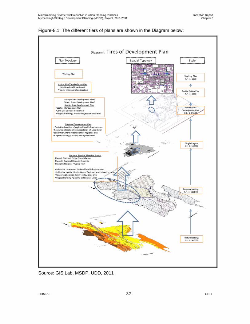
Figure-8.1: The different tiers of plans are shown in the Diagram below:
Source: GIS Lab, MSDP, UDD, 2011
Mainstreaming Disaster Risk reduction in urban Planning Practices Inception Report Mymensingh Strategic Development Planning (MSDP), Project, 2011-2031 Chapter 8
CDMP-II 33 UDD
8.2 Methodology for Accomplishment of the Project Each tiers of plan are prepared in different stages. The stages of planning procedure
for the project are described below:
8.2.1 Reconnaissance Survey: A reconnaissance survey was made by UDD Team to get a preliminary idea about
the project area. During reconnaissance survey preliminary meetings were held with
different stakeholders of the project are.
8.2.2 Preparation for Surveys and Planning: At the same time, necessary actions for preparation of conducting surveys and
planning are also under processing. The preparatory activities for surveys and
planning include:
1. Delineation of planning area and meeting with different stakeholders.
2. Collection of mouza maps and preparation of base map.
3. Procurement of image and image processing including digitization, data
management and printing.
4. Establishment of Bench Mark (BM) Pillar.
5. Geo-Processing of Base Map
During this time, various national level policies and plans of different sectoral
agencies would be analyzed to adapt with the proposed structure planning process.
8.2.3 Conducting Surveys: The following surveys would be made in urban and rural areas by using Real Time
Kinematic Global Positioning System (RTK GPS) and Total station:
1. Physical feature survey
2. Topographic surveys
3. Existing land use surveys
Besides conducting the above-mentioned surveys, the following surveys and studies
would also be conducted:
1. Socio-economic surveys
2. Hydrological studies
3. Transportation studies
Mainstreaming Disaster Risk reduction in urban Planning Practices Inception Report Mymensingh Strategic Development Planning (MSDP), Project, 2011-2031 Chapter 8
CDMP-II 34 UDD
4. Settlement surveys
5. Environmental and Ecological Surveys and Studies
6. Baseline survey of Existing Flora and Fauna
7. Conducting Participatory Rapid Appraisal (PRA) and Attitude Survey
8. Conducting Environmental Impact Assessment (EIA)
9. Studies for Energy and Food Grain
10. Social Space Studies
11. Studies of Institutional Setup of various similar authorities
8.2.4 Collection of Data and Information: Data and information would be collected from both primary and secondary sources through various surveys and studies but not limited to the surveys and studies mentioned above to prepare plan for the project area.
Primary Data and Information: Both spatial and attribute data including qualitative and quantitative that would
be collected from various surveys and studies but not limited to the above-
mentioned.
Secondary Data and Information: Various government agencies, institutions would be approaches to collect
secondary data and information (Both Spatial and Attribute), which would be
necessary to prepare plan for the project area. A list of various government
agencies and institutions that would be approached to collect secondary data
and information, but not limited to, including the nature and type of data are
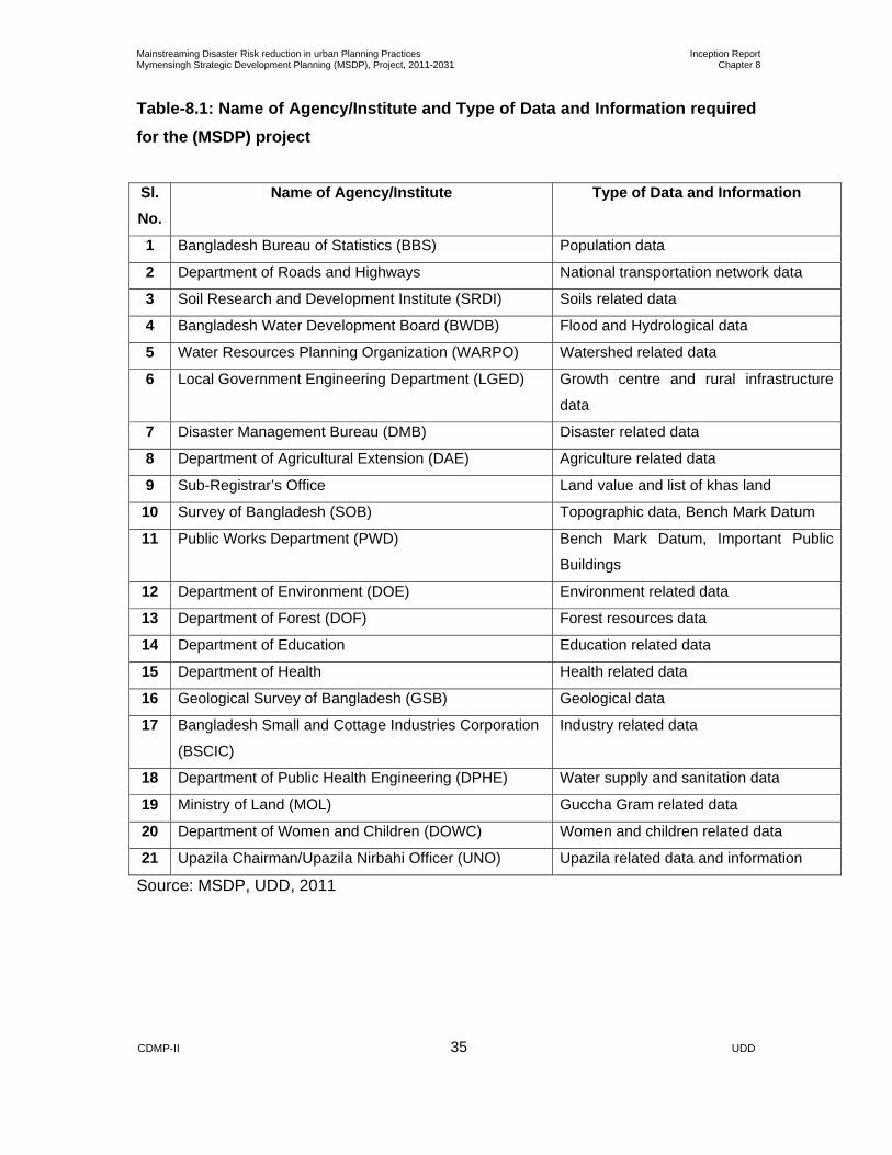
illustrated the Table-8.1 below.
Mainstreaming Disaster Risk reduction in urban Planning Practices Inception Report Mymensingh Strategic Development Planning (MSDP), Project, 2011-2031 Chapter 8
CDMP-II 35 UDD
Table-8.1: Name of Agency/Institute and Type of Data and Information required for the (MSDP) project
Source: MSDP, UDD, 2011
Sl. No.
Name of Agency/Institute Type of Data and Information
1 Bangladesh Bureau of Statistics (BBS) Population data
2 Department of Roads and Highways National transportation network data
3 Soil Research and Development Institute (SRDI) Soils related data
4 Bangladesh Water Development Board (BWDB) Flood and Hydrological data
5 Water Resources Planning Organization (WARPO) Watershed related data
6 Local Government Engineering Department (LGED) Growth centre and rural infrastructure
data
7 Disaster Management Bureau (DMB) Disaster related data
8 Department of Agricultural Extension (DAE) Agriculture related data
9 Sub-Registrar’s Office Land value and list of khas land
10 Survey of Bangladesh (SOB) Topographic data, Bench Mark Datum
11 Public Works Department (PWD) Bench Mark Datum, Important Public
Buildings
12 Department of Environment (DOE) Environment related data
13 Department of Forest (DOF) Forest resources data
14 Department of Education Education related data
15 Department of Health Health related data
16 Geological Survey of Bangladesh (GSB) Geological data
17 Bangladesh Small and Cottage Industries Corporation
(BSCIC)
Industry related data
18 Department of Public Health Engineering (DPHE) Water supply and sanitation data
19 Ministry of Land (MOL) Guccha Gram related data
20 Department of Women and Children (DOWC) Women and children related data
21 Upazila Chairman/Upazila Nirbahi Officer (UNO) Upazila related data and information
Mainstreaming Disaster Risk reduction in urban Planning Practices Inception Report Mymensingh Strategic Development Planning (MSDP), Project, 2011-2031 Chapter 8
CDMP-II 36 UDD
The collected all primary and secondary data and information would be analyzed
based on the following criteria:
1. Ecological parameters
2. Demographic data
3. Existing land use
4. Administrative and institutional
5. Land suitability
6. Economic base
7. Inter and intra regional connectivity
8. Available resources
9. Peoples attitude; and
10. Disaster risk and vulnerability of the area
On the basis of the analyzed data; development prospects and constraints would be
framed out, which would be presented in a potentiality matrix.
The potentiality matrix would be then synthesized and outcome of the analysis finally
presented in the form of:
1. Development control matrix
2. Spatial representation (a set of thematic maps)
8.2.5 Basic Planning Structure: The development control matrix and the spatial representation would form a
Comprehensive Planning Package in the form of:
Structure Plan (Period 20-Year)
Urban Rural Area Plan (Period- 10 Year)
Rural Area Plan (Period- 10 Years)
Detailed / Action Area Plan(Period-05 Year)
The above mentioned planning structure would contain various types of plans
including Spatial Plan (physical and social infrastructure), Environmental
Conservation Plan, Environmental Management Plan, Institutional Development
Programme, Financial Management Plan, social Space Plan, Water Management
Plan, Energy Management Plan, Food Grain Management Plan and So on. Finally,
preparation of Structure Area Plan, Urban and Rural Area Plan and Action Area Plan
on the basis of analyzed data and information. A Schematic Diagram Showing

Mainstreaming Disaster Risk reduction in urban Planning Practices Inception Report Mymensingh Strategic Development Planning (MSDP), Project, 2011-2031 Chapter 8
CDMP-II 37 UDD
Methodology (annex-8.1) for Preparation of Development Plan has been shown in
Figure-8.2 below:
Figure- 8.2: Schematic Diagram for Preparation of Development Plan
Mainstreaming Disaster Risk reduction in urban Planning Practices Inception Report Mymensingh Strategic Development Planning (MSDP), Project, 2011-2031 Chapter 8
CDMP-II 38 UDD
8.2.6 Step Wise Activities for Accomplishment of the Project:
STEP 1: MOBILIZATION, RECONNAISANCE SURVEY, PROJECT DESIGN AND SUBMITION OF INCEPTION REPORT
Deployment of Key Personnel and supporting staffs, conducting reconnaissance
survey; initiate the collection of maps and other secondary materials; procurement of
logistics and preparation of detailed working schedule; and submission of inception
report . STEP 2: COLLECTIONS OF MAPS, BASIC STATISTICS AND INFORMATION
To start the planning process the existing situation of the planning area has to be represented in a set of maps and in a collection of basic statistics and information.
Step 2-I Collection of Mouza maps
Original CS, RS and BS mouza maps will be collected from DLR/ DC office by
the consulting firms for respective DAP Area. Distortion due to rapping or
pasting clothes/tape in the mouza maps will not be accepted.
Step 2-II Collection of Geo-physical maps and reports Includes
• Geology (sedimentation, stratification, fault lines, lineaments etc.)
• Hydrology (contour lines, water bodies/courses, embankments, pump
house, related structure etc.)
• Soils major type.
• As a first ‘overlay’ to the, base map the geo-physical situation of the
planning area has to be given. Step 2-III Collection of Topographical maps and reports Includes
• Physical features (land/water, urban/rural, built-up/open, landmarks,
bridge/culvert, and embankment/floodwall, sluice gate)
• Infrastructure (drainage, roads, public transportation and utilities)
• Land use (in broad categories such as residential, industrial, commercial,
agricultural, flood flow, etc. each differentiated according to density and
quality)
• As a second overlay the existing topographical features has to be shown:
• Most of the information can be derived from existing sources (desk
research).

Mainstreaming Disaster Risk reduction in urban Planning Practices Inception Report Mymensingh Strategic Development Planning (MSDP), Project, 2011-2031 Chapter 8
CDMP-II 39 UDD
• At this stage field visits by the planning team are useful to get a general
impression of the character and the quality of the planning area. STEPS 2-IV Collection of Basic statistics: present activities
• Number of inhabitants/households, differentiated according to income
level/type/density and quality of housing
• Production and employment (formal/informal, number and size of
establishments, type of production/activity, income/education level)
• Public services (education, health, security etc.) and utilities (drinking
water, sewerage/sanitation, garbage disposal, gas, electricity,
telecommunication); administrative institutions
• Commercial activities (shops, markets both formal and informal)
• Transportation facilities (roads, public transportation, parking facilities,
waterways, railway, foot path)
Step 2-V Development 2001-2011
• For the most important statistics is the historic development over the last
census period (2001-2011), with implicated annual growth rates.
Step 2-Vl Submission of Inception Report The report should include the following (with necessary
maps/figures/diagrams/graphs etc.)
1. An introduction narrating the purpose of the study, objectives and
scope of services and activities to be performed.
2. A Review of the work plan, time schedule, input and management plan.
3. An assessment of the actual provision of inputs in relation to the
expected outputs.
4. Analysis and findings from reconnaissance survey including problems
and possible solutions to the survey activities and prospects of
development.
5. Review of all relevant reports, documents and other materials, which
will from the base for the contract indicating those items already
acquired and those requiring official assistance for acquisition.
6. An assessment of all additional data collected and survey works to be
carried out for completion of the database for the contract. This should

Mainstreaming Disaster Risk reduction in urban Planning Practices Inception Report Mymensingh Strategic Development Planning (MSDP), Project, 2011-2031 Chapter 8
CDMP-II 40 UDD
be accompanied by a detailed program for the collection of the
remaining data.
7. Development of methodology for each component of the structure plan.
STEP 3: PREPARATION AND COMPILATION OF BASE MAP AND DEMARCATION OF PROJECT BOUNDARY OF PROJECT BOUNDARY/AREA/LOCATION (1) A review of the work plans and time schedule for the remaining period of the
contract.
(2) Activities to be performed by the consultants for Survey Report:
• Establishment of Ground Control Point (GCP)
• Digitization and Geo-referencing of Mouza Map Sheet Boundaries (at least
30% mouza map of the project area)
• Completion of satellite image processing
Step-wise detailed activities to be performed by the consultants are described below:
STEP 3-l Geo-referencing of Mouza Maps ( 1 kilometer grid) Geo-referencing of mouza maps comprises the following items:
STEP 3-ll Selection of Ground Control Point (GCP)
• At least 4 nos. of GCP (Tic) should be selected in ground for each of
mouza sheet for conducting GCP survey. The joint team of UDD and
consulting firms will select the GCP. Geo-referenced (x, y, z) permanent
Bench Mark (BM) pillars uniformly distributed covering the project area have
to be established to carry out the total topographic, physical feature and land
use survey. Design, drawing of BM pillars have to be approved by the Project
Director (PD)
STEP 3-III GCP Survey
• GCP survey will be carried out using GPS based static survey technique.
The positional accuracy level of GCP survey must be <± 1meter. Survey data
(GPS) and Total Station data) will be stored in BTM (EVEREST 1830)
Projection (Northing Easting ellipsoidal/SOB/PWD height in meter) system in
an available file format. However, conversion into Arc/Info format will be made
with data stored in format All GCP survey data both soft and hard copy will be
submitted to UDD immediately after completion of GCP survey.
Mainstreaming Disaster Risk reduction in urban Planning Practices Inception Report Mymensingh Strategic Development Planning (MSDP), Project, 2011-2031 Chapter 8
CDMP-II 41 UDD
STEP 3-lV Scanning of Mouza Maps
• Scanning of mouza maps will be carried out using drum scanner. Flat bed
scanner is not allowed for scanning of mouza maps Rotation and alignment
must be maintained during scanning of mouza maps.
STEP 3-V Digitization of Mouza Maps
• On screen digitisation method will be used for digitisation of mouza maps.
Arc/lnfo software will be used for this purpose. Feature wise manuscripts will
be developed for digitising the mouza maps and all features will be stored as
layer coverage with a separate ID or code number of respective features in
the GIS database. To keep uniqueness of all features the ID or code numbers
of respective features will be finalised as per suggestion and discussion with
Project Director (PD). STEP 3-VI Manuscript 01: Point Features.
• This manuscript will contain all point features like boundary and other
pillars, traverse stations, GT stations, benchmarks etc. Every point will contain
a numeric user ID representing feature type.
STEP 3-VI manuscript 02: Polygon Features
• This manuscript will contain all polygon type features or closed boundary
like water bodies. land uses, and topography. All features will be closed
polygon and every polygon will contain a numeric user ID representing feature
type.
STEP 3-VlII. Manuscript 03: Line Features.
• This manuscript will contain all line type features like administrative
boundaries, roads, drainage, electricity, water, gas and sewerage line,
bridge/culvert, embankment/flood wall, sluice gate, water ways, rail ways etc.
STEP 3-IX Edit Plot Checking of Digitized Coverage
• After digitization of mouza maps edit plots will be produced containing all
the features in different colours. The digitized mouza maps will be checked
and verified by superimposing on the original mouza maps using the light
table. This checking will be done with the joint team of UDD and the
respective GIS/RS consultant. By this edit plot check all possible errors
(missing arcs, dislocated arcs, wrong or missing polygon labels, tic location
Mainstreaming Disaster Risk reduction in urban Planning Practices Inception Report Mymensingh Strategic Development Planning (MSDP), Project, 2011-2031 Chapter 8
CDMP-II 42 UDD
and ID etc) will be solved and final digitised mouza maps will be prepared.
After finalisation of digitisation of mouza maps , all data both soft and hard
copy will be submitted to Project Director (PD)
STEP3-X Joining of Mouza Maps and Demarcation of Study Area.
• Joining of mouza maps will be done using Arc-Info based GIS software
where surveyed GCPs will be used as TIC point. Afterward all Geo-
referencing mouza sheets will be joined and Mouza map will be prepared
using Arc View software. The geo-reference mouza maps will be prepared in
original mouza scale. This map lay out will be submitted to Project Director
(PD) in hard and soft format.
• Study area will be demarcated by joint team, duly approved and signed by
Project Director (PD) which will be considered as project area.
• While joining mouza maps, edge matching shall be performed in
consultation with the PD.
STEP 3-Xl Preparation of GIS Map Lay Out.
• A standard map layout will be developed with consultation of Project
Director (PD). Scale, Paper size and Grid for preparation of map lay out will
be determined in consultation with the PD. Legend for features in the map will
be selected from the available symbol palettes in Arc/View will be used to
develop a standard layout. BBS geo-code may be used for administrative unit.
STEP 4: Satellite Image processing by using Photogrammetric method Photogrammetric method uses satellite/aerial stereo images to create Digital
Elevation Model and make geospatial database more effectively. With the advent of
latest trends in the technologies and unique customer requirements,
photogrammetry is now the leading technology for mapping. The field of
photogrammetry is a rapid science with new technologies being developed
constantly. Within a short period of time, the practice of photogrammetry has
changed from analog to digital. The development of digital aerial cameras has
advanced significantly over the past 4-5 years. The use of digital aerial images would
be more advantageous for all map and image production especially for Digital vector
data and Orthophoto generation.
Mainstreaming Disaster Risk reduction in urban Planning Practices Inception Report Mymensingh Strategic Development Planning (MSDP), Project, 2011-2031 Chapter 8
CDMP-II 43 UDD
Step 4-I Methodology
• Since the internal precision of extracted DEMs is strictly related to the
mean scale of photographs, image quality, pixel dimension and, obviously,
morphology of the area, Image Collection is a crucial part of the project.
Image will be collected from Satellite image provider.
• The Satellite image in 0.5-meter panchromatic and 1.74-meter multi
spectral four-band images in stereo pairs will be procured for town area. The
0.5-meter pan and 1.74-meter multi spectral imagery will also be fused to
yield 0.5-meter color imagery (pan-sharpened). 2.5-meter stereo image will
also be collected for country area.
Step 4-II Image Processing
• Image processing will be done after collecting raw digital images. The tasks
involved in image processing are - Epi-polar Correction
- Color Balance
- Contrast Adjustment
- Sharpening
- Pyramid
- Bit Rate Setting
Step 4-III GCP Collection
• Ground control points will be selected by photo identification of existing
ground features. Considerable number of GCP will be collected as required for the
whole study area. All GCPs will be collected by conducting field survey using RTK
GPS method. After collecting GPS data of the GCP, post processing will be done
day to day in the sites. Accuracy level will be maintained within 10 cm.
Step 4-IV Aerial Triangulation
• Aerial Triangulation is a mathematical process used to determine the real
world position, height from mean sea level and orientation of each photograph. Aerial
Triangulation will provide the accurate stereo (3D) model of image. One of the most
advanced aerial triangulation is Inpho Match-AT.
Mainstreaming Disaster Risk reduction in urban Planning Practices Inception Report Mymensingh Strategic Development Planning (MSDP), Project, 2011-2031 Chapter 8
CDMP-II 44 UDD
Input for AT Output of AT
- IMU, RPC data
- GPS (on board)
- GCP (collected from field)
- Image
Georeferenced Stereo Model
Step 4-V Digital Mapping from Stereo Model
• After the orientation of stereo models, digital mapping will be carried out. We
propose ArcGIS Geodatabase/shapefile model for storing geo-spatial data. The
proposed Geodatabase and its Feature classes will be designed based on the
followings:
- Projection Parameters of the Coordinate System
- Name and type of layer (feature classes)
- Structure of Attribute Tables of the Feature classes
• Digital Photogrammetric Workstation e.g. Datem Summit Evolution (DPW) will
be used as the platform for acquiring features from digital stereo images (model).
• Feature registration will be done considering and measuring the position of
the object under its accuracy level. The Summit Evolution & Stereo Plotter of
DAT/EM will be used for identifying and registration of the objects and ArcGIS 9.3 or
upper version of ESRI will be used for vector data storing and editing.
Step 4-VI Attribute Data Collection
• Attribute data of the features will be collected from the field after producing
base map. It will be a step by step procedure.
Step 4-VII Map Updating
• Attribute data collected from the field, will be incorporated into the features in
this stage.
Step 4-VIII Field Check
• Field checking will be done check the following:
- Dimension and shape of the features
- Accuracy of feature’s attributes
- Missing objects.
- Data will be collected by total station where cloud will be found in the
image or some object which is not able to identify in image.

Mainstreaming Disaster Risk reduction in urban Planning Practices Inception Report Mymensingh Strategic Development Planning (MSDP), Project, 2011-2031 Chapter 8
CDMP-II 45 UDD
Step 4-IX DTM/DEM/TIN/Contour Generation
• DTM Point: Digital photogrammetry is able to acquire 3D points for high
spatial resolution DEM generation through semi-automatic procedures, overcoming
the problems of process. In the approach, DTM Points will be generated from Stereo
Pair images by the software, and editing of the software generated DTM points will
be done by the Photogrammetrist comparing them with stereo model. Creating and
editing of Breaklines will be done after this stage.
• Contour: After creating DTM Points, Contour lines will be produced l. The
contour lines will be delivered in 1 km x 1 km or 5 km x 5 km blocks or one single file
for the project area.
• DEM: Using DTM Points DEM will be generated at a resolution of 10 meters
in 1 km x 1 km or 5 km x 5 km blocks or one single file for the project area.
• TIN: Using DTM Points TIN will be generated and delivered in 1 km x 1 km or
5 km x 5 km blocks for the project area.
• OrthoPhoto: An orthophoto or orthophotograph is a photograph which terrain
corrected ("orthorectified") such that the scale is uniform: the photo has the same
lack of distortion as a map. Orthophotographs are commonly used in the creation of
a Geographic Information System (GIS).
a. Ortho-rectification of Images Orthorectification is a process by which image distortions caused by topography and
image orientation are geometrically corrected by the incorporation of a terrain model.
Ortho-rectification of every image will be carried out using digital photogrammetric
system based on result of aerial triangulation and the generated DEM.
b. Mosaicing of OrthoPhoto Individual rectified photograph will be assembled to form seamless mosaic.
Mosaicing of OrthoPhoto includes the following tasks
i) Seam line Drawing: Drawing the boundary of the image delineating which part
of the image will go which image.
j) Balancing of Color and Contrast within different images
k) Feathering
Mainstreaming Disaster Risk reduction in urban Planning Practices Inception Report Mymensingh Strategic Development Planning (MSDP), Project, 2011-2031 Chapter 8
CDMP-II 46 UDD
Step 4-X Submission of PROGRESS REPORT ON SURVEY
• Study Area Map (Digital copy in ARC/INFO format & Hard Copy) along with
report stating the status of collected information, procedure of establishment of
permanent Ground Control Point (GCP) and Temporary Ground Control Point
(TGCP), Scanning, digitization and compilation of Mouza Map, demarcation of study
area boundary including the technical specifications have to be submitted.
STEP 5. SURVEY ACTIVITIES (Field Survey information in original format have to be submitted to the Project Director (PD) at the end of every week.)
(1) A review of the work plans and time schedule for the remaining period of the
contract.
(2) Activities to be performed by the consultants for Survey Report:
• Digitization and Geo-referencing of Mouza Map Sheet Boundaries (at least
70% mouza map of the project area)
• All survey data including
Topographic Survey
Physical Feature Survey
Hydro-geological Survey
Land Use Survey
Socio-Economic Survey
Other related survey (traffic survey, baseline survey of flora and fauna,
environment studies, disaster studies, social space studies etc.)
Collection of Socio Economic data from published sources
Step-wise detailed activities to be performed by the consultants are described below:
Step 5-I Topographical Ground Truthing Survey
• Topographic survey will cover the following features:
• Topographic survey by using RTK-GPS and Total Station to obtain 3-D
data (X,Y, Z value)-location and alignment of all roads, flood embankments
and other drainage divides. Location and alignment of all drainage and
irrigation channels/canals showing depth and direction of flow. Closed
boundary/outline of homestead, water bodies, swamps, forest etc. junctions,
Mainstreaming Disaster Risk reduction in urban Planning Practices Inception Report Mymensingh Strategic Development Planning (MSDP), Project, 2011-2031 Chapter 8
CDMP-II 47 UDD
spot heights or land levels at roughly 10 m intervals for urban area and 20 m
intervals for rural areas.
• All collected raw data shall be submitted to PD before processing.
• Generating contours at 0.5 meter intervals with denser intervals for
undulations.
• Alignment and crest levels (not exceeding 50meter) of road, embankment,
dykes and other drainage divides.
• Alignment of rivers, lake, canal and drainage channels etc
• Outline of bazaars, water body, swamps etc.
Step 5-ll Physical Infrastructure Survey
• All existing structures position and dimension (3-D-X,Y, Z value).
• Cross section, long section, type, width, length and name of road, road
level above datum, flooding, land slopes, borrow pit.
• Identification of any bridge or culvert on the road and their length, width
and span of the bridge, condition of abutments, condition of the dyke, wing
walls abutment.
• Type, size, depth, inlet and outlet location of drain along with flow direction
width and depth of the canal, place of encroachment.
• Type of sewer system, size, type and location of sewerage line, location of
bins, identification of any other sewerage collection system.
• Identification of the water supply system, location of deep tubes well,
overhead water tank and its capacity, catchment area of overhead tank.
• Identification, location and capacity of electric substation, telephone
exchange, Titas gas subs station etc. Treatment plant and waste disposal
facilities.
• Identification, location and capacity of electricity, telephone, gas, and
waste disposal and treatment system.
Step 5-III LAND USE SURVEY UPDATING
• Land use information have to be extracted from physical feature survey as
per specification of TOR. After completion of data processing and draft
mapping, land use survey have to be updated through field verification.
Mainstreaming Disaster Risk reduction in urban Planning Practices Inception Report Mymensingh Strategic Development Planning (MSDP), Project, 2011-2031 Chapter 8
CDMP-II 48 UDD
Step 5-lV SOCIO ECONOMIC SURVEY STEP 4-lV-A House -hold Sample survey will be done using the approved
Questionnaire based on specified Questionnaire format indicated in TOR. Sample
size will be minimum 2.5% of total population.
STEP 4-lV-B Case Studies will be conducted highlighting the issues like housing for
disadvantaged group, informal economic activity, traffic congestion, drainage, water
logging, unauthorized encroachment, waste disposal, play ground and park,
stakeholders participation for planning and development control.
Step 4-IV-C Inventory of survey will have to be prepared as per format. Data
processing, analysis of survey data, mapping and reporting will be made as
per requirement. Step 5-V Other Related Surveys
Other related surveys and studies (traffic survey, hydrological studies, bathymetric report studies, hydro-geological survey, baseline survey of flora and fauna, environment studies, disaster studies, social space studies etc.) shall also be conducted in consultation with PD.
Step 5-VI Submission of Survey Report along with maps and chart (physical feature, hydro-geology, land use & socio-economic) for approval.
STEP 6 HIGHER LEVEL FRAMEWORKS (1) A review of the work plans and time schedule for the remaining period of the
contract.
(2) Activities to be performed by the UDD Team for Draft Interim Report (if
necessary):
• Digitization and Geo-referencing of Mouza Map Sheet Boundaries(100%
mouza map of the project area)
• Preparation of Map for draft Structure Plan , Rural Area Plan, Urban Area
Plan, Detailed Area Plan/Action Plan, Integration of Disaster Related Data into
Planning Process, and Institutional Development Programme and Environmental
Management Plan and other related planning package (for Structure Plan, Rural
Area Plan, Urban Area Plan, Detailed Area Plan/Action Plan, Spatial Plan,
Environmental Conservation Plan, Institutional Development Programme And
Environmental Management Plan, Financial Management Plan and Social Space
Plan)
Mainstreaming Disaster Risk reduction in urban Planning Practices Inception Report Mymensingh Strategic Development Planning (MSDP), Project, 2011-2031 Chapter 8
CDMP-II 49 UDD
• Working paper shall be prepared by concerned UDD Team members and all
individual consultants as well.
• Results and analysis of the collected data (For Structure Plan, Rural Area
Plan, Urban Area Plan, Detailed Area Plan/Action Plan, Spatial Plan, Environmental
Conservation Plan, Institutional Development Programme And Environmental
Management Plan, Financial Management Plan and Social Space Plan).
• Formulation of Strategies for Structure Plan, Urban Area Plan, Rural Area
Plan and Action Plan
• After completion of the picture of the existing situation at the start of the planning process, information has to be collected on the framework offered by higher level plans. First, policies, guidelines and strategies shall be developed under structure plan and urban/rural area plan. Detailed Area Plans shall be formulated following the planning provisions made under structure plan and urban/rural area plan.
Step-wise detailed activities to be performed by UDD drafting team are described
below:
STEP 6-I Digitization and Geo-referencing of Mouza Maps ( 1 kilometre grid)
• Digitization and Geo-referencing of Mouza Map Sheet Boundaries (at least
70% mouza map of the project area): step-wise activities have been
discussed in step 3.
Step 6-II Higher Level Plans
• Statements relevant to the planning area have to be summarised from higher
level plans including Structure Plan and Urban/Rural Area Plan and also from the
provision made under previous master plans prepared during 1980s. Successes
and failures of these plans have to be discussed, with lessons for present
planning to be learnt from these.
Step 6-III Relevant Structure Plan and Urban Area Plan information
• Demographic and socio-economic projections and targets (taking into account
different income levels, investment levels, formal vs. informal sector, etc.)
Mainstreaming Disaster Risk reduction in urban Planning Practices Inception Report Mymensingh Strategic Development Planning (MSDP), Project, 2011-2031 Chapter 8
CDMP-II 50 UDD
• Major elements/principles of the drainage system including, flood flow and
sub-flood flow zones.
• Major roads/public transportation network
• Other major infrastructure elements (pipes and cables, drinking water and
sewage treatment plants, deep tube well, solid waste, clinical waste, industrial
waste, commercial waste disposal, gas and electricity substation etc.)
• Special functions (airport, cantonment, police and BDR headquarter etc.)
• Agriculture, flood-flow, sub flood- flow, retention pond, water protection and
nature preservation zones
• Hazardous zones (natural and man made)- Different types of disasters
including cyclone, flood, earthquake, changing of river course and so on.
• Major recreational zones, historical monument.
• Phasing of development
Step 6-IV Area conversion
• Expected population growth (or any other variable of interest that is given for
Spatial Planning Zones) have to be split up according to the surface proportions.
Step 6-V Existing versus new urban area
• Next a clear analysis is necessary: the area which is partially developed will
be absorbed by existing urban areas, the area where the growth that has to be
accommodated in new urban areas.
• Here a rough approach may be followed to start with, followed by a more
refined analysis.
• For the refined analysis the density development approach that shall be
adopted by the Structure Plan may be used, and also an analysis of latest census
based trend extrapolations for Detailed Area Plan.
• The plan will have to be adjusted when the outcome of the refined analysis,
differs greatly from the rough approximation.
• A basis for the planning period will be established for computing additional
need of infrastructure, public facilities and space for commercial functions in
existing urban area. For computing the requirements of new urban area
(necessary infrastructure, facilities and services), that has to be provided

Mainstreaming Disaster Risk reduction in urban Planning Practices Inception Report Mymensingh Strategic Development Planning (MSDP), Project, 2011-2031 Chapter 8
CDMP-II 51 UDD
• Thus the phasing of the development will get the spatial analysis that is
needed to draw up the Detailed Area Plans.
Step 6-VI Infrastructure
• Information on the roads network and the drainage system, utility supply
system, (as offered in the Structure Plan and the Urban/Rural Area Plan) needs
further elaboration prior to its inclusion in Detailed Area Plan. Step 6-VII Transfer to Base Map
• All information from the Structure Plan and the Urban Area Plan has to be
transferred to the base map, as a third overlay.
• Attention should be given to the ‘symbolic’ character of the Structure Plan and
Urban Area Plan information. In the Structure Plan and the Urban Area Plan no
exact alignments, locations etc. are given, but only indications.
• A Detailed Area Plan should not just copy these symbolic indications (e.g. by
photographically enlargement) but fulfil its specific function to transform the
indications into concrete plan proposals that are related in a meaningful way to
the base map and to the existing topography.
STEP 7 COMMUNICATION PLAN AND FIRST CONSULTATION: Concern to local communities/beneficiaries and other agencies/interest group (stakeholders)
Step 6 is the first consultation, following the collection of basic information on the existing
situation of the planning area and on the planning package. At all stages of the planning
process interested parties (other government agencies, non-government organization, local
communities, private developers, etc.) have to be consulted.
Further consultations will concern the Base Map planning proposals, the public sector action
program and the legalization process.
Step 7-I Communication Plan
• For consultations (also in later stages) it is advisable to draw up a separate
Communication Plan and reserve sufficient budget for the implementation of this
plan.
• In the Communication Plan an inventory has to be made of interested parties,
according to the following categories:

Mainstreaming Disaster Risk reduction in urban Planning Practices Inception Report Mymensingh Strategic Development Planning (MSDP), Project, 2011-2031 Chapter 8
CDMP-II 52 UDD
I) Public agencies (concern ministries, semi-government, utility, agencies and
companies, local government, etc.) ii) Local communities (e.q. elected representatives, community leaders, local CBO’s)
iii) Private developers
iv) Relevant NGOs
v) Professional and business groups. For each category/party the proper approach has to be ascertained in the Communication Plan.
Step 7-II Public Agencies
• Inventory of existing plans by public agencies, and of ongoing or scheduled
implementation projects.
• Inventory of public sector objectives and wishes, and of spatial problems, which
affect these objectives, and wishes.
• The inventory has to start with desk research, followed by additional
consultations. Step 7-III Local Communities
• Same as step 6-II, but directed at local communities/community leaders/ CBO’s.
• As not much information is readily available, emphasis has to be placed on direct
consultations, with careful introduction of the background, the status and the purpose
of the project to avoid conflicts and make meetings fruitful.
• Communities and their leaders have to be asked which of their problems they will
be able to solve by themselves and for which they need government support.
Step 7-IV Private Developers
• Same as step 6-II, but directed at major private developers.
• Here it is important to be well informed on agreements that have already been
reached, licenses or concessions already granted and applications still being
processed, before starting direct consultations.
Step 7-V NGOs
• Same as step 6-II, but directed at NGOs.
• NGOs may work both on a town (or even national) and community level.
• At town/national level, typical one-issue advocacy organisations may be relevant,
in the fields of poverty alleviation, woman’s rights, environmental protection, urban
Mainstreaming Disaster Risk reduction in urban Planning Practices Inception Report Mymensingh Strategic Development Planning (MSDP), Project, 2011-2031 Chapter 8
CDMP-II 53 UDD
heritage preservation, etc. also business organisations exist in the study area may
be included in this category.
• At the community level, NGOs may be important partners in the implementation
of community based development (e.g. by offering small-scale credit for
improvement of shelter and basic services/utilities).
Step 7-VI Summary
• Information resulting from the consultations (existing plans and ongoing or
scheduled projects; objectives, wishes and problems; community, private sector and
NGO initiatives) has to be summarised in a section of the explanatory report and,
where applicable, collected as a fourth overlay on the base map. Step 7-VIII Submission of draft Interim Report (Optional)
Step 7-IX Fulfillment of requirements of the Technical Committee about the Draft Interim Report (Optional)
DRAFT FINAL REPORT At this stage the UDD Project Team Members are expected to submit the Draft Plan
including Detailed Area Plan/Action Plans and the investment components to a
standard degree of detail as appropriate for appraisal with economic viability analysis
and calculation of opportunity cost for such projects by the prospective lending
agency. Detail recommendations for the programming and scope of possible land
acquisition and resettlement procedures shall also be included in this report.
STEP 8: SECOND CONSULTATION FORMULATION OF PLANNING PRINCIPLES/STANDARDS
• This is a very important stage in the design process, crucial to the final functional
quality of the result and its efficiency and cost effectiveness. Planning principles
have to address two distinct situations: existing and new urban areas (with a further
distinction between small-scale incremental and large-scale planned development).
• For the two situations, planning principles and design rules will work in a different
way. Whereas in new urban areas there is a great deal of freedom to make ‘ideal’
design decisions, in existing situations in most cases only a gradual improvement
and restructuring is feasible and desirable.
Mainstreaming Disaster Risk reduction in urban Planning Practices Inception Report Mymensingh Strategic Development Planning (MSDP), Project, 2011-2031 Chapter 8
CDMP-II 54 UDD
• In existing urban areas, the quality of the buildings, the infrastructure, the general
lay-out, the public space, findings of the survey of the existing situation is the starting
point.
• Here design principles and standards cannot be implemented right away, but
serve rather as a reference, or target, to be approximated to a degree that depends
on available budget, willingness of local inhabitants to co-operate, ability to have
formal developers ‘adopt’ these principles and standards.
• According to these opportunities, infrastructure may be upgraded, land
readjustment, guided land development or slum clearance carried out, relocation
schemes (either on or off site) implemented, facilities and open space introduced,
etc.
• Special attention has to be given to manage development in existing urban areas.
While in fringe areas that are still only partially developed, the design aims at more
efficient land use by increasing density, in fully developed areas that are already very
dense, measures have to be taken to match the already high and still increasing
densities with the required facilities and services (always as related to infrastructure
capacity and sustainable environment)
• Arrangement of separate consultation with representative of different interest
group to formulate the design is desirable.
Step 8-I Existing Urban Area
• For the existing urban area density control guideline and to a certain extent also
for incremental development of new urban area, planning principles and appropriate
technique may be adopted as mentioned below:
i) Urban renewal.
ii) Land readjustment
iii) Guided land development
iv) Site-and-Services
v) Community based area development.
vi)Land acquisition
vii) Land purchase
• Applicability of the techniques of land development depends mainly on densities.
Community Based Development is the proper approach for those areas where only
Mainstreaming Disaster Risk reduction in urban Planning Practices Inception Report Mymensingh Strategic Development Planning (MSDP), Project, 2011-2031 Chapter 8
CDMP-II 55 UDD
very little open space remains. Where somewhat more unoccupied space is
available guided land development may be the most suitable approach. Larger tracts
of open land offer opportunities for site-and-services schemes and (where under low
development pressures) for land pooling or land readjustment schemes, for
infrastructure development land acquisition and for private developer land purchase.
Step 8-II Land Management study
• Community based development of (hard core poor) low-income housing facilities
in the existing urban area and the urban fringe area through consultation with
facilitator and users.
• Land pooling/land readjustment and guided land development both aim at
improving accessibility and at providing better services without the (compulsory) land
acquisition by government agencies.
• Success depends to a high degree on limiting the amount of land that is needed
for these purposes. Therefore improvement of accessibility should aim at widening
and improving capacity of existing roads (and providing some missing links) rather
than the construction of completely new roads.
• Similarly, the provision of services should not go beyond strict minimum
standards. New neighbourhood centres (in which most services should be
concentrated) in newly developing areas can be located just outside existing urban
areas, so that they serve both the new development and the existing area. For good
accessibility these centres should be situated near the major junctions of the road
network.
• Minimum standards for some urban services shall be determined by reviewing
similar development projects. In some cases, minimum standard has be developed.
• In land readjustment and guided land development schemes some space will be
available for new development, but improving the existing situation deserves more
attention. Here one of the most important issues is giving support to occupants to
improve the quality of their own shelter (security of tenure, access to small scale
loans, cheap building materials).
• In site-and-services schemes the most important issue is matching the plot size
distribution to the income distribution of the expected/targeted future inhabitants.
Mainstreaming Disaster Risk reduction in urban Planning Practices Inception Report Mymensingh Strategic Development Planning (MSDP), Project, 2011-2031 Chapter 8
CDMP-II 56 UDD
Step 8-III New Urban Area
• For the development of new urban area, especially large scale planned
development; there is more freedom to adopt formal design principles.
• In general the approach for new urban areas starts with the design of the major
infrastructure networks (drainage, roads, public transportation), followed by other
types of infrastructure such as drinking water, sewerage, electricity, gas, etc.
• The networks have to be combined as much as possible to prevent waste of
space.
• Once the combined infrastructure network has been established, the design
process has to deal with land use in each of the ‘cells’ of the network. Here plot size
and principles for clustering and accessibility are the most important issues.
• Most of the work on infrastructure networks shall be developed for the Structure
Plan and Urban Area Plan.
Step 8-IV Drainage
• Among different types of infrastructure drainage has by far the heaviest impact on
the design especially on Physical Infrastructure network.
• Data and information relating to existing drainage system (e.g., storm water
drainage and sewerage system) shall collected from paurashava authority,
concerned agency (e.g., LGED) and collected data and information shall be
analyzed to make recommendation on the drainage system of the project area.
• Natural drainage system shall be identified and recommendation shall be made
to maintain the natural drainage system.
• Discharge capacity for drainage shall be calculated and drainage layout plan
shall be prepared for the project area.
Step 8-V Roads
• Detailed road network shall be designed according to the provisions that shall be
made under structure plan and urban/rural area plan.
• Reservations may also be made for bus lanes or even light railway tracks.
Step 8-VI Conflict of drainage and waterways with road network
• A point of special attention is offered by the conflict of the road network with the
drainage network and waterways.

Mainstreaming Disaster Risk reduction in urban Planning Practices Inception Report Mymensingh Strategic Development Planning (MSDP), Project, 2011-2031 Chapter 8
CDMP-II 57 UDD
• As so much land will be covered by khals and ponds that often follow a quite
irregular pattern, (even in the case of one of the less space extensive alternatives
proving feasible) there is a serious risk that a substantial part of the best serviced
land will in fact not come available for development.
• Roads have to be aligned in such a way (and when necessary khals and ponds
have to be somewhat remodelled) that as much as possible of the land along the
roads can be put to high value uses, with khals and ponds in a peripheral position.
• Canals along roads may make an exception to this principle as they may be
considered as reserve space for later intensification (if necessary).
• The combination of roads and drainage networks with waterways where feasible
offers a typical cross section of formal (planned) urban development.
Step 8-VII Geological Faults
• Geological land classification shall be prepared from the hydro-geological study,
which may pose restriction to urban development (especially high rise construction),
the alignment of the zone of influence has to be ascertained, while special building
conditions may have to be included in the explanatory report that goes with the
Detailed Area Plan/Action Area Plan.
Step 8-VIII Plot Size
• For each of the major land use categories and ‘ideal’ plots have to be assessed,
in relation to land use density and affordability levels as well as ways to cluster plots,
making them accessible, and with proper orientation.
• Plot design also helps to establish typical land use/functional combinations (e.g.
schools, shops, health care, playgrounds, etc. in residential areas). Clusters of
typical land use (or land use combinations) have to fit in the cells of the (combined)
infrastructure network, with mutual adjustment when they do fit after a first design
cycle.
• Here special care has to be given to the relation between affordability and
occupancy density on the one hand and infrastructure capacity on the other.
• After mutual adjustment, the combined land use clusters and infrastructure
network cells provide the basic units for further location related design work.
• Whereas the first consultation of step 5 was directed at collecting information on
problems, wishes and initiatives of interested parties prior to the start of the proper
Mainstreaming Disaster Risk reduction in urban Planning Practices Inception Report Mymensingh Strategic Development Planning (MSDP), Project, 2011-2031 Chapter 8
CDMP-II 58 UDD
planning work; the separate consultation with different group of this step aims at
getting reactions to the design.
• On this level of scale, covering the area as a whole, direct participation of local
communities does not seem feasible. So for this step mainly local authorities and
local community leaders should be identified and consulted.
STEP 9 INTEGRATED PLANS: IMPACT ASSESSMENT, ECONOMIC AND FINANCIAL VIABILITY, SOCIAL AND ENVIRONMENTAL IMPACT ASSESSMENT
Step 9-I Integrated Plan
• Inputs from different sectors, local leaders, Interest group will be consolidated
and an Integrated Plan Proposal have to be formulated. Parallel to the consultations,
different types of impacts of the design have to be assessed.
• According to the reactions and to the outcome of the impact assessment,
adjustments to the design have to be considered.
Step 9-ll Impacts Following consultations, the next stage is to assess impacts.
• Impact on environment and ecology
• economic impact
• Impact on cultural practice, tradition and heritage
• impact on social relations, norms, customs and values
• impact on existing infrastructure
These impacts have to be set off against general objectives, standards and targets.
Step 9-III Financial Viability
• Further into this stage, financial viability has to be checked. This means that
rough calculations have to be made of investment costs, differentiating between
public and private sector investments, and the latter again between formal
developers and individual owners, small scale businessmen, etc. Cost calculations
should rest on simple information of average costs per unit, derived from recent
experience. Costs have to be set off against budget and affordability information.
• The check on financial viability should also be subject to consultations as
mentioned above.

Mainstreaming Disaster Risk reduction in urban Planning Practices Inception Report Mymensingh Strategic Development Planning (MSDP), Project, 2011-2031 Chapter 8
CDMP-II 59 UDD
Step 9-lV Adjustment of the Plan
• After finishing the second round of consultation and conducting all the checks,
the plan has to be adjusted before making the next steps in the design process.
• Special attention has to be given to any conflicts arising between Structure Plan
and Urban Area Plan/ Rural Area Plan, objectives and principles with sectoral and
lower level plans that become apparent through the consultations, impact
assessments and viability checks. These conflicts have to be solved before
continuing the design process for the Detailed Area Plans/Action Area Plan.
• In an ideal case, none of these conflicts would occur, with Detailed Area Plan
proposals based on consensus among all interested parties.
• If this is not achieved, then clear decisions have to be taken by the authorities in
charge, to solve situations that otherwise would block progress.
STEP 10 Third Consultation: Incorporation of Development Proposals in Response to the community desire
Step 9 is the start of the actual design work, applied to the specific situation of each Detailed Area Plan.
Attention has to be given to three aspects of the quality of the result:
i) Functional quality (meeting of space requirements for different
functions, relations between. functions, capacity and efficiency of infrastructure and
affordability).
ii) Aesthetic quality (agreeable environment)
iii) Flexibility (adaptability to future change; sustainability)
iv) Sustainable Environment (Protection of Environmental Quality) Step 10-I Planning Strategies
• First, for the area as a whole and for sub-areas, planning strategies have to be
formulated.
• For the area as a whole derive mainly from the Structure Plan and Urban Area
Plan (e.g. designation as ‘urban fringe area, targeted for rapid development’ or
‘urban core area targeted for urgent rehabilitation’ etc.).
• For sub-areas, first the difference between existing and new (as yet unoccupied)
urban area has to be established, and then for each the proper strategy has to be
Mainstreaming Disaster Risk reduction in urban Planning Practices Inception Report Mymensingh Strategic Development Planning (MSDP), Project, 2011-2031 Chapter 8
CDMP-II 60 UDD
identified (such as land readjustment, guided land development, site-and-services for
existing urban area, and large scale formal development or small scale incremental
development for new urban area).
• Preferred strategies have to relate to major infrastructure development (level of
protection against cyclone, earthquake, flood, change in the course of river and
drainage, quality of transportation network, coverage of utilities networks, etc.).
Step 10-I I Existing Urban Area
• Once the base map with its four overlays (geo-physical situation, topography,
higher level plans, outcome of first consultations) is ready and the basic
development strategies have been formulated, for existing urban areas as well as
unplanned (small scale incremental development) new areas, the functional design
work just comes down to applying the planning principles that result from the survey
and Study.
• For these purposes land management technique for sub-areas: land
readjustment, guided land development and site-and-services schemes have to be
identified, and these have to be combined with road widening/missing link proposals
and locations for neighbourhood centres.
Step 10-III New Urban Area
• For new urban areas, after formulating the preferred strategies, the functional
design comes down to fit the basic units for planned development into the map in
such a way that the space needs for different functions can be met.
• The space needs derive from the demographic and socio-economic projections
and targets from the Structure Plan and Urban Area Plan . Functions and land use
categories have to be taken from step 2 & 3, including different levels of
density/affordability. It is crucial to pay attention to optimum spatial relations between
functions, closeness for functions that generate much mutual traffic, distance when
one function may have negative impact on another. Step 10-IV Hierarchy of Centres
• For new urban areas this approach will lead to a more or less homogeneous
pattern of occupation to which has to be added the distribution and hierarchy of
urban centres and commercial areas, and the distribution and size of recreational
areas and open space.
Mainstreaming Disaster Risk reduction in urban Planning Practices Inception Report Mymensingh Strategic Development Planning (MSDP), Project, 2011-2031 Chapter 8
CDMP-II 61 UDD
• The number and level of urban centres depends on standards to be developed
for the project area and shall be designed accordingly. As these standards may
change over time, keeping a certain amount of reserve space for these elements are
advisable.
Step 10-V Aesthetic Quality Next to functional considerations the design has also to take care of aesthetic qualities. A number of points of attention may be mentioned:
• Profile, alignment and ‘greening’ of major infrastructure elements
• A clear distinction between formal development (frontage) along major
infrastructure and more informal development inside infrastructure ‘cells’
• Composition of high-rise and low-rise construction zones, as related to
infrastructure and landscape
• Typical landscape elements as rivers, khals, canals, lakes and ponds, forest, tree
lanes etc. to be preserved and enhanced when existing, to be created when it is
required. The plan should seize the opportunity to use these elements to emphasise
the identity of the area and come to a more location specific design.
• Beautification of special elements and special zones (historical places, places of
cultural and religious importance, urban centres, important institutions, major
roads/public transportation intersections, etc.) by using sight lines, vistas,
landscaping, open space, composition of building masses and other architectural
means.
Step 10-VI Flexibility
• Finally, flexibility and sustainability of the design deserve special attention.
• It should be easy to adapt the design to future changes, without previous
investments being lost.
• Here too a number of points may be mentioned for consideration:
• Increasing infrastructure capacity without the need to partly demolish already
developed areas (reservation of sufficient Rows);
• Intensifying of commercial functions (keeping pace with general economic
development);
• Upgrading of low level/low intensity land use and ‘face lifting’ of buildings and
public space including waste management.
• Change of land use and function.

Mainstreaming Disaster Risk reduction in urban Planning Practices Inception Report Mymensingh Strategic Development Planning (MSDP), Project, 2011-2031 Chapter 8
CDMP-II 62 UDD
• Restricting expansion of polluting/hazardous industry within sphere of influence of
existing residential areas and environmentally sensitive zones;
• Reserving open space for unforeseen development (or admitting temporary/
informal use with explicit rules for evacuation in the case of the space being needed
for formal development.
• Reserving space for future urban use as urban deferred.
Step 10-VII Deviations
• Closely related to the design concept of flexibility in the institutional concept of
dealing with deviations.
• Rules have to be formulated for dealing with minor deviations (that do not
seriously affect the plan) by executive authorities, and for easy adjustment of the
plan when major deviations prove necessary, involving the legalising body as well as
consultations with other government agencies, local communities and major
owners/developers.
• These rules should safeguard sufficient security for inhabitants and investors,
striking a balance between flexibility and reliability. It may even be considered to give
compensation in case of major changes of plan that seriously damages the interest
of individual inhabitants/owners/investors.
• The design process as described for this step will seldom show satisfying results
at once. Mostly the whole sequence has to be repeated a number of times,
generating alternative solutions and evaluating these, until finally the design has
reached a sufficient level of quality. Designing is always an ‘iterative’ process.
• This iterative process continues over the following steps, where checking the
results of the design work in the second consultation with interested parties,
checking financial viability, then adjusting the plan, then elaborating the plan on a
more detailed level, then checking and adjusting again, all have this iterative
character. Step 10-VIII Additional Field Survey
• Part of the iterative design process is making further field surveys, not as a
general activity covering the whole area and addressing every possible item, but
guided by actual design problems and questions.
Mainstreaming Disaster Risk reduction in urban Planning Practices Inception Report Mymensingh Strategic Development Planning (MSDP), Project, 2011-2031 Chapter 8
CDMP-II 63 UDD
• For example the boundary of the built-up area may need more exact assessment,
or the occurrence of obstacles in the alignment of a proposed road or canal, or the
precise location of low lying areas to be used for natural retention ponds, etc.
• Also more detailed socio-economic information may be needed in this stage,
especially to support a community based development approach.
Step 10-IX Integrated Planning Map
• The result of this stage of the design work has to be recorded as a first draft of
the Integrated-planning map.
• For the integrated planning map, the existing situation as shown on the
different layers of the base map has to be summarised, and planning proposals have
to be added.
Step 10-X Consultation
• As in step 8, the consultations are directed at sub-areas. Community participation
may now involve communities as a whole, in stead of only their leaders.
• This consultation should try to avoid renewal of discussions that were already
settled during the first check. Otherwise what was intended as a process that may be
iterative, but still makes steady progress, will get stuck in endlessly repeated circular
movements without moving forward at all.
• Consultations and impact assessments may lead to adjustments, in this case to
the plan.
• For successful involvement, it is important to identify communities that show a
sufficient degree of social cohesion and that are clearly distinct from neighbouring
communities.
• These communities should neither be too big or too small. When communities
are too big, it will prove impossible to organise a dialogue in which individual
members can participate. When communities are too small, too many meetings have
to be organised, making the whole consultation process unmanageable.
• Once the communities have been identified and relations have been established,
a community based development approach can be adopted.
• For this approach, the internal social structure of each community has to be
determined on the basis of socio-economic survey and organisations set up to bring
Mainstreaming Disaster Risk reduction in urban Planning Practices Inception Report Mymensingh Strategic Development Planning (MSDP), Project, 2011-2031 Chapter 8
CDMP-II 64 UDD
various parties/interests together with involved public agencies (the latter with
special attention to local authorities).
• Next, community meetings have to be held and working teams have to analyse
the problems of the specific site and to find out what the community is willing to do to
address these problems. Community ‘motivators’ may assist the weaker parts of the
community in formulating their specific wishes and may help them to organise
themselves in groups that have their voice heard in the planning and implementation
process.
Step 10-Xl Public Agency Support
• The public agencies involved in the process have to identify what part of the
problems they will be able to address, and how they are willing to solve these in a
combined effort with the community. On the other hand, the community should
express what action they could take themselves, both individually and as a group.
• General checks on available resources, as mentioned for the next step, are of
special importance here. Otherwise, solutions will prove not to be implemented, and
whatever trusts in the capability and willingness of the public authorities that has
been built up during the process, will get lost and turn into disappointment and a
general uncooperative attitude instead.
• As community based development of this type is very intensive and time
consuming, it may not be possible to cover all relevant areas as part of the
preparation of a Detailed Area Plan. In that case, one or two critical areas should be
selected as ‘pilot areas’ to demonstrate the approach, leaving the remaining areas
for later elaboration, as part of the general implementation process.
STEP 11 PRIORITIES AND PHASING; PUBLIC SECTOR ACTION PROGRAM
• In this step a difference has to be made between improving the existing urban
situation and accommodating new development.
• For the existing situation, priorities depend on the urgency of problems (e.g.
cyclone, river bank erosion, changing in river courses, earthquake, flooding, lack of
safe drinking water and sanitation, garbage disposal, industrial waste management,
traffic congestion etc.).
• For new development, priorities depend on an estimate of areas that will show
the fastest growth.
Mainstreaming Disaster Risk reduction in urban Planning Practices Inception Report Mymensingh Strategic Development Planning (MSDP), Project, 2011-2031 Chapter 8
CDMP-II 65 UDD
• Special attention has to be given to situations in which infrastructure and utilities
serving new development (and paid for by this new development) can serve existing
urban areas with serious deficiencies at the same time. Step 11-I Priorities
• Assessment of development priorities according to urgency of problems and
dynamics of development. Step 11-II Phasing
• Phasing has to be derived from priorities, for five-year periods (,2011-2015, 2015-
2020, beyond).
• In this stage the phasing represents an ‘ideal’ development over time, without
consideration of budget constraints.
Step 11-III Public Sector Action Program
• In this step the ideal phasing is set against available public sector budgets and
overall sectoral priorities. In most cases, this will require adjustments to the initial
phasing, leading to a ‘public sector action program’.
• Additional consultations with public sector agencies in charge of various parts of
the program will be necessary to finalise the action program.
STEP 12 DEVELOPMENT CONTROL, ZONNING AND LAND MANAGEMENT This step deals with development management and zoning, with special attention to land management.
Step 12-I Development Control and Management
• A system for development control, management and zoning shall be developed
as part of the Urban Area Plan/Rural Area Plan. This system may be similarly
applied for Detailed Area Plans.
• Special attention should be given to dealing with revisions (e.g. adjustments,
modifications, and variations) while implementing the plan. As already stated the
development management system must offer an easy way to deal with minor
revisions, while at the same time a guarantee is provided that no major revision will
be allowed without previous legalisation of a (partial) plan review. So revisions also
need attention in the legalisation procedure as laid down in the explanatory report to
the plan. The Urban Area Plan shall summarise the interim development control and
management proposals.
Mainstreaming Disaster Risk reduction in urban Planning Practices Inception Report Mymensingh Strategic Development Planning (MSDP), Project, 2011-2031 Chapter 8
CDMP-II 66 UDD
Step 12-I I Land Management: Existing Urban Area
• Effective land management is one of the most important tools for the
implementation of spatial plans.
• For existing urban areas of middle to high densities, the most effective
approaches are urban rehabilitation/upgrading and land sharing, either or not
involving community based development techniques for which proper institutional
and financial mechanisms have to be established.
• For existing urban areas with relatively low densities, government agencies may
also acquire land, for construction of infrastructure and provision of urban service,
but also for the implementation of site-and-service schemes that offer low cost plots
to low income households. Mechanism for institutional and financial support for
disadvantaged group has to be established like cross- subsidy etc.
• Site-and-services schemes may also be offered by private developers, including
cross subsidising, as part of the conditions that such schemes have to fulfil in order
to obtain a development license for a larger area. Here too, institutional provisions
are needed to make this spatial land management technique work effectively.
Step 12-III New Urban Areas
• By strengthening land management instruments for large scale new development
(financial conditions attached to development licenses, betterment fee, property tax,
etc.) government expenses resulting from these external effects may be recovered,
offering also the opportunity to contribute to the improvement of adjoining existing
urban areas.
• Owners of land that is either difficult accessible or not in the immediate
development pressure zone, may be induced to co-operate in land development or
land pooling schemes. The financial gain for the landowners on the higher valued,
but smaller plot will work as the incentive while the costs of infrastructure and the
necessary space may be (partly) recovered from the land made available by the
landowners.
• In areas with heavy development pressure, developments often overtake the land
pooling or readjustment efforts. Here Land Consolidation Schemes may assure
acquisition of sufficient space and provision of infrastructure services, which may be
recovered later through betterment fee and property taxation.

Mainstreaming Disaster Risk reduction in urban Planning Practices Inception Report Mymensingh Strategic Development Planning (MSDP), Project, 2011-2031 Chapter 8
CDMP-II 67 UDD
STEP 13 LEGAL SUPPORTING DOCUMENTS FOR IMPLEMENTATION For implementation of prepared plan necessary legal supporting documents for
institutional use of every sector with specific responsibility and operation procedure
to be followed have to be prepared professionally.
STEP 14 REPORTING The explanatory report has to clarify the plan and give an account of the basis for its
preparation (including consultations and implementation procedure). Report shall be
presented and illustrated in a clear and concise professional manner, including
maps, plans, diagrams and other graphics.
STEP 15 UPDATING OF PLAN AND REPORT INCORPORATING OF COMENT S OF FORMAL PUBLIC HEARING AND FINAL SUBMISSION
FORMAT OF EXPLANNERY REPORT (This is a tentative format of explanatory
report. Content of the report shall be finalized in consultation with CDMP.)
Chapter 1 - Background
• In this chapter the purpose and format of Detailed Area Plan has to be explained.
• Also in this chapter a description of the planning area should be provided
following the base map compilation and collection of basic statistics as represented
in steps (basic statistics, administrative, geo-physical and topographic information).
Chapter 2 - Critical Planning Issues
• This chapter opens with a description of the existing development pattern, as
derived from the basic statistics.
• The description focuses on quantitative and qualitative aspects of present socio-
economic activities, on land use, and on land ownership and value. Next to the
present situation development over time has to be analysed.
• Next, the chapter should give an account of expected population growth as well
as the expected development of economic activities. These expectations derive from
the Structure Plan and Urban Area Plan in most cases an area conversion will prove
necessary.
Mainstreaming Disaster Risk reduction in urban Planning Practices Inception Report Mymensingh Strategic Development Planning (MSDP), Project, 2011-2031 Chapter 8
CDMP-II 68 UDD
• Then an overview of urgent problems is presented those stems from an analysis
of the present situation (e.g. cyclone, river bank erosion, changing in river course,
earthquake, flooding, infrastructure and service deficits, geological faults, etc.). The
problems may partly be identified by desk research, but mostly they have to be
assessed by direct consultations with interested parties, according to step 5.
• Finally in this chapter current investment programs have to be summarised, also
partly from desk research and partly from consultations.
Chapter 3 - Development Plan Proposals
• In the first part of this chapter further relevant Structure Plan and Urban Area
Plan statements are collected.
• As a second part, design principles and standards are developed.
• Then, as the third part of the chapter, these principles and standards are applied
to the planning area, working from preferred development strategies that are
selected to solve the present problems of the area and to guide its further
development.
• Development strategies are mainly directed at the type of development for sub
areas (for existing urban areas either community based rehabilitation, upgrading and
renovation or communal land sharing, for the direct fringe Guided Land
Development, while in the new areas either sites (and services), land readjustment
or land pooling or simple incremental development by individual land owners will
take place).
• The fourth part of the chapter also deals with major infrastructure proposals.
• The fifth and last part gives a description of the integrated planning map in which
all the design proposals are brought together.
Chapter 4 - Plan Implementation
• In this chapter, area development priorities and phasing are given, followed by
the public sector action program and a description of the system of development
management and zoning
• The chapter ends with a discussion of land management issues that are relevant
to the implementation of the plan
Mainstreaming Disaster Risk reduction in urban Planning Practices Inception Report Mymensingh Strategic Development Planning (MSDP), Project, 2011-2031 Chapter 8
CDMP-II 69 UDD
Chapter 5 - Project Plan(s)
• In most cases, the preparation of Project Plans will follow the same approach as
the preparation of the Detailed Area Plan itself. The Project Plan, however, will show
more detail and will generally place more emphasis on the aesthetic qualities of the
design.
• For Project Plans, the appropriate scale for the integrated planning map is 1:1000
while important details (e.g. major road junctions with adjoining commercial and
district or neighbourhood centres) may be illustrated at an even larger scale (1:500).
Chapter 6 – Follow up
• In the last chapter of Draft Final Plan Report, an overview should be given to
follow up activities.
• First this overview addresses the preparation of additional Project Plans after the
Detailed Area Plan has been completed and legalised.
• Next it deals with the regular updating/reviewing of the Detailed Area Plan/Action
Area Plan (e.g. every five years).
• Finally it gives rules for deviations while implementing the plan. A difference has
to be made, based on clear and objective criteria, between minor deviations that can
be handled by executive officers, and major deviations that require a partial review of
the plan, followed by a new legalisation procedure.
Annexure
• The explanatory report has to be concise and simple. On average it should not
contain more than 30 or 40 pages of text. Elaborate statistics, analyses and
calculations have to be relegated to annexes rather than included in the main text.
• Next to statistics etc. the annexes also give an account of all the consultations
that have been held while preparing the plan, together with an account of the
legalisation process.
Illustrations
• The text of the report has to be lucid and clear as mostly illustrations have a far
greater explanatory power than mere text.
• Most of the illustrations are of a simplified character, included in the text (A4 or
A3 size; 1:20,000 or 1:10,000 scale).

Mainstreaming Disaster Risk reduction in urban Planning Practices Inception Report Mymensingh Strategic Development Planning (MSDP), Project, 2011-2031 Chapter 8
CDMP-II 70 UDD
• The integrated planning map has to be reproduced on a 1:10,000 scale for those
users that need the plan in the first place for its information on future developments.
• For users that are in charge of development management and zoning the
planning map has also to be reproduced on a 1:3,960 or 1,980 scale (in several
sheets).
• Base maps may either be included in simplified form in the text only
• As the preparation of the explanatory report more or less exactly follows the
same steps as the preparation of the Detailed Area Plan in general, starting the work
on the report need not wait until the end of the planning process. In fact writing the
report and preparing the illustrations can start right at the beginning, completing the
report as a parallel activity.
STEP 16: FINAL REPORT The UDD team embers shall present the final recommendations on the Plan after
incorporating the client’s comments. This report shall include a detailed description
of works under the Development Plan to be implemented in phases. Cost estimates
for these works should be worked out in detail, based on recent quotations from
contractors for similar works.
Presentation (a) Study result should be presented in two forms: first on the map of RF 1:
10,00,000 indicating the national/ regional settings and RF 1: 5,00,000 indicating the
planning area; secondly in report form. The design of the map should be appropriate
in size so that it is not difficult for handling. The Scale, colors and indications to be
used shall be according to the instruction of the PD.
(b) Final study results shall be analyzed, interpreted and presented in Report form.
(c) Reports shall be prepared in MS word 2007 version and font shall be Times New
Roman 12 pt
(d) All table, graph, diagram, chart, map shall be interactive with its original program
such as MS Office and GIS
(e) All report shall be submitted in Web format
(f) Audio-visual presentation shall be made by UDD team members before
submitting each and every report

Mainstreaming Disaster Risk reduction in urban Planning Practices Inception Report Mymensingh Strategic Development Planning (MSDP), Project, 2011-2031 Chapter 8
CDMP-II 71 UDD
Deliverable:
• Working papers concerned with objectives of the study (both hard and soft
copy)
• All database management to be handed over to the client
• All collected data, information, book, journal and other relevant documents to
be handed over to the client
• Original set of Image if procured by the consulting firm.
• All customized data base management system for user
• All equipment and furniture procured for the project
Progress Reports: Progress Reports shall have to be submitted to CDMP by UDD
in every 3 (three) month on the basis of the approved working schedule.
• Medium of language of the progress report shall be English.
• Both soft copy and hard copy shall be submitted by the consulting firm.
• Progress report shall be submitted within 1st week of the next quarter
3.9 Information leaflet (Submission at the end of the First month) (1) The leaflet will be used by UDD to publicize the project.
(2) A short illustrated five page leaflets describing the project, giving reasons for the
project and advantages expected to be generated by the project.
(3) 5000 copies of such leaflet should be prepared and supplied by CDMP.
(4) Periodical paper and TV cable advertisements shall be arranged by CDMP.
Others (i) The consultant requires to gather 3-D data (all feature’s vertex must have Z
value) to identify flood flow zone (Main/sub), water logging, drainage system,
drainage congestion, to get profile of road (any where), identify features more
correctly and accurately and also to create precise DEM, it is very much needed to
have 3D data.
(ii) After completion of survey works and after submission of Final Report a Seminar
/ Workshop should be arranged by the UDD with the elite, Draft reports, Public
representative businessmen, professionals etc. of the region.
Mainstreaming Disaster Risk reduction in urban Planning Practices Inception Report Mymensingh Strategic Development Planning (MSDP), Project, 2011-2031 Chapter 8
CDMP-II 72 UDD
The individual consultants have to submit working paper after completion of the
assignment as directed by the PD and also require submitting fortnightly progress
report to the PD on the assigned task.
Data, personnel, facilities and local services to be provided by the client UDD would provide project office with furniture/fixtures to the individual consultants.
3.10 Institutional arrangements Technical Management Committee (TMC) and Quarterly Activity Review Committee
(QARC) should be set up to monitor the project.