9 the landscape character types forming the 9 the ... the landscape character types forming the ......
TRANSCRIPT

Figure 9.1 Types forming the setting of the AONB
138
The Landscape Character Types Forming the 9Setting of the AONB
Introduction and location
9.1 The setting of the AONB includes both those areas from where the AONB can be seen, i.e. when looking towards the AONB and areas which are seen from the AONB, when looking out from within its boundaries. The section below provides some information about the landscape character types and areas which abut the AONB and form the setting to the AONB, as well as guidance for managing changes which could affect the AONB.
9.2 The types forming the setting of the AONB include:
• Landscape Character Type G: Drumlin Farmland
• Landscape Character Type H: Low Coastal Drumlins
• Landscape Character Type I: Lowland Valley and Coastal Margins
Figure 9.1 Types forming the setting of the AONB
120
9 The Landscape Character Types Forming the Setting of the AONB
Introduction and location
9.1 The setting of the AONB includes both those areas from where the AONB can be seen, i.e. when looking towards the AONB and areas which are seen from the AONB, when looking out from within its boundaries. The section below provides some information about the landscape character types and areas which abut the AONB and form the setting to the AONB, as well as guidance for managing changes which could affect the AONB.
9.2 The types forming the setting of the AONB include:
• Landscape Character Type G: Drumlin Farmland
• Landscape Character Type H: Low Coastal Drumlins
• Landscape Character Type I: Lowland Valley and Coastal Margins

Views to the Landscapes Surrounding the AONB
9.3 Views out of the AONB to the surrounding lowlands and hills, particularly across Morecambe Bay and the Kent Estuary and to the southern fells of the Lake District, Whitbarrow, Hutton Roof, Yorkshire Dales and the Forest of Bowland AONB are an essential and integral part of the Arnside and Silverdale AONB, and one of its special qualities.
9.4 To the north, the setting includes Meathop and Milnthorpe Marshes, and the southern fells of the Lake District National Park, and Whitbarrow Scar.
9.5 To the east, the setting includes Holme, Burton and Hilderstone Mosses, Milnthorpe, Beetham and Borwick drumlin farmland, beyond which lie Farleton Fell, Hutton Roof, and Holmepark Fell, and the Yorkshire Dales National Park, including Ingleborough and Whernside. To the north it includes the Howgills.
9.6 To the south the Warton flood meadows, the drumlin farmland and coastal marshes along the east side of Morecambe Bay, Carnforth, the Forest of Bowland AONB and Lancaster, including the Ashton Memorial, and Blackpool Tower form part of the setting.
9.7 To the west, the setting to the AONB includes Morecambe Bay, Grange-over-Sands, Humphrey Head Point, the low fells extending south from Ulverston on the far side of Morecambe Bay, and the Furness Peninsula.
Forces for Change Affecting the Setting of the AONB
9.8 The following forces for change are of relevance to the setting of the AONB.
• Climate change affecting the character of landscapes and seascapes in many ways, through sea level rise and changes in the extents of land and sea, changes in vegetation, loss of trees in storms, changing water tables, increased winter flooding, or summer drying and soil erosion through blowing dust, and so on;
• Responses to climate change and sea level rise such as managed realignment and ceasing to drain low lying areas like Milnthorpe Marsh, possibly changing the use and appearance of landscapes which form the setting to the AONB;
• Changes in demand for food or fuel crops affecting the pattern of farming, the types of crops grown and the character of the landscape outside the AONB, perhaps as a consequence of climate change;
• Changes in traditional countryside management such as strimming of hedges instead of more traditional laying, use of fences instead of repairing walls, enlargement of field sizes by removal of boundaries in response to the demands of larger machinery;
• Pressure for renewable energy development, including on and offshore wind farms and tidal energy schemes, and nuclear energy development on the west Cumbria coast along with associated grid infrastructure and the effects of these types of development on the character of the setting of the AONB, the views into the AONB from outside and those looking out of the AONB;
• Pressure for other types of development including that associated with industry, tourism and leisure, and new housing.
• The effects of all types of development outside the AONB on the setting of the AONB as experienced both when looking in to the area, and on the views out of the AONB, for example affecting characteristic skylines;
• The influences of the north-south transport corridor - A6, railway, M6 and Lancaster Canal, and pressure for infrastructure development such as a high speed train route, or major new electricity grid connections, and all associated ancillary development, or the possible reopening of the Lancaster Canal to boats;
• Expansion of residential, recreational and commercial development across the areas outside the AONB, including around Carnforth to provide commuter housing areas for Lancaster, industrial estates and retail outlets.
• Pressures for mineral extraction including quarrying, non-conventional oil and gas extraction, sand and gravel extraction and the effects upon the setting of the AONB;
• Changes in the planning system or means of protecting designated landscapes, such as the Lake District and Yorkshire Dales National Parks, or the Forest of Bowland AONB, which can alter the degree of likely change across the setting to the AONB.
121
Guidelines
Table9.1Guidelines-LandscapeCharacterTypeG:DrumlinFarmland,HLowCoastal DrumlinsandILowlandValleyandCoastalMargins
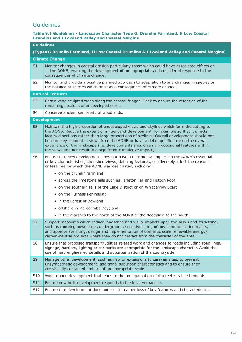
Guidelines
(TypesGDrumlinFarmland,HLowCoastalDrumlins&ILowlandValleyandCoastalMargins)
ClimateChange
S1 Monitorchangesincoastalerosionparticularlythosewhichcouldhaveassociatedeffectson theAONB,enablingthedevelopmentofanappropriateandconsideredresponsetothe consequencesofclimatechange.
S2 Monitorandprovideapositiveplannedapproachtoadaptationtoanychangesinspeciesor thebalanceofspecieswhichariseasaconsequenceofclimatechange.
NaturalFeatures
S3 Retainwindsculptedtreesalongthecoastalfringes.Seektoensuretheretentionofthe remainingsectionsofundevelopedcoast.
S4 Conserveancientsemi-naturalwoodlands.
Development
S5 Maintainthehighproportionofundevelopedviewsandskylineswhichformthesettingto theAONB.Reducetheextentofinfluenceofdevelopment,forexamplesothatitaffects localisedsectionsratherthanlargeproportionsofskylines.Overalldevelopmentshouldnot becomekeyelementinviewsfromtheAONBorhaveadefininginfluenceontheoverall experienceofthelandscape(i.e.developmentsshouldremainoccasionalfeatureswithin theviewsandnotresultinasignificantcumulativeimpact).
S6 EnsurethatnewdevelopmentdoesnothaveadetrimentalimpactontheAONB’sessential orkeycharacteristics,cherishedviews,definingfeatures,oradverselyaffectthereasons orfeaturesforwhichtheAONBwasdesignated,including:
• onthedrumlinfarmland;
• acrossthelimestonehillssuchasFarletonFellandHuttonRoof;
• onthesouthernfellsoftheLakeDistrictoronWhitbarrowScar;
• ontheFurnessPeninsula;
• intheForestofBowland;
• offshoreinMorecambeBay;and,
• inthemarshestothenorthoftheAONBorthefloodplaintothesouth.
S7 SupportmeasureswhichreducelandscapeandvisualimpactsupontheAONBanditssetting, suchasrouteingpowerlinesunderground,sensitivesitingofanycommunicationmasts, andappropriatesiting,designandimplementationofdomesticscalerenewableenergy/ carbon-neutralprojectswheretheydonotdetractfromthecharacterofthearea.
S8 Ensurethatproposedtransport/utilitiesrelatedworkandchangestoroadsincludingroadlines, signage,barriers,lightingorcarparksareappropriateforthelandscapecharacter.Avoidthe useofhardengineereddetailsandsuburbanisationofthecountryside.
S9 Manageotherdevelopment,suchasneworextensionstocaravansites,toprevent unsympatheticdevelopment,additionalsuburbancharacteristicsandtoensurethey arevisuallycontainedandareofanappropriatescale.
S10 Avoidribbondevelopmentthatleadstotheamalgamationofdiscreetruralsettlements.
S11 Ensurenewbuiltdevelopmentrespondstothelocalvernacular.
S12 Ensurethatdevelopmentdoesnotresultinanetlossofkeyfeaturesandcharacteristics.
122
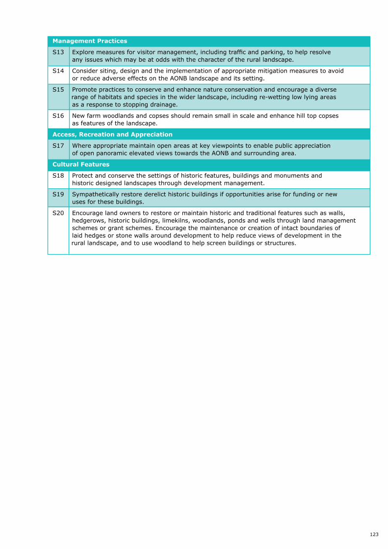
Management Practices
S13 Explore measures for visitor management, including traffic and parking, to help resolve any issues which may be at odds with the character of the rural landscape.
S14 Consider siting, design and the implementation of appropriate mitigation measures to avoid or reduce adverse effects on the AONB landscape and its setting.
S15 Promote practices to conserve and enhance nature conservation and encourage a diverse range of habitats and species in the wider landscape, including re-wetting low lying areas as a response to stopping drainage.
S16 New farm woodlands and copses should remain small in scale and enhance hill top copses as features of the landscape.
Access, Recreation and Appreciation
S17 Where appropriate maintain open areas at key viewpoints to enable public appreciation of open panoramic elevated views towards the AONB and surrounding area.
Cultural Features
S18 Protect and conserve the settings of historic features, buildings and monuments and historic designed landscapes through development management.
S19 Sympathetically restore derelict historic buildings if opportunities arise for funding or new uses for these buildings.
S20 Encourage land owners to restore or maintain historic and traditional features such as walls, hedgerows, historic buildings, limekilns, woodlands, ponds and wells through land management schemes or grant schemes. Encourage the maintenance or creation of intact boundaries of laid hedges or stone walls around development to help reduce views of development in the rural landscape, and to use woodland to help screen buildings or structures.
123
142
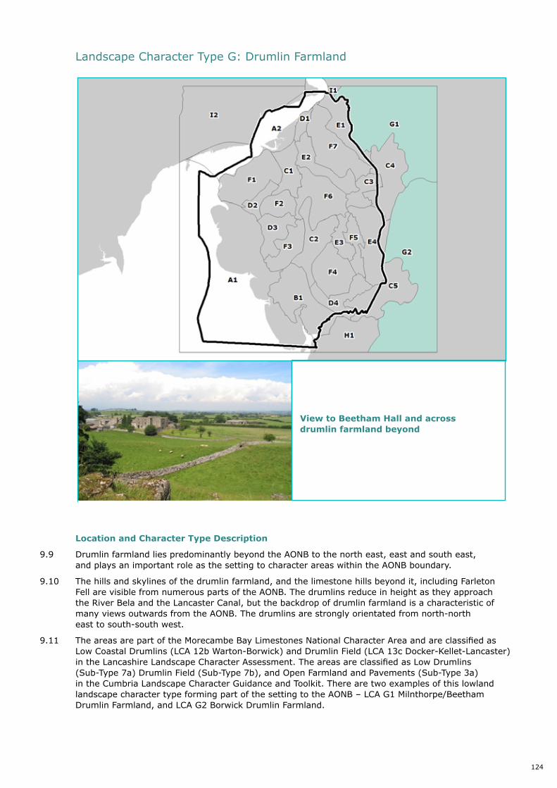
Landscape Character Type G: Drumlin Farmland
Location and Character Type Description
9.9 Drumlin farmland lies predominantly beyond the AONB to the north east, east and south east, and plays an important role as the setting to character areas within the AONB boundary.
9.10 The hills and skylines of the drumlin farmland, and the limestone hills beyond it, including Farleton Fell are visible from numerous parts of the AONB. The drumlins reduce in height as they approach the River Bela and the Lancaster Canal, but the backdrop of drumlin farmland is a characteristic of many views outwards from the AONB. The drumlins are strongly orientated from north-north east to south-south west.
9.11 The areas are part of the Morecambe Bay Limestones National Character Area and are classified as Low Coastal Drumlins (LCA 12b Warton-Borwick) and Drumlin Field (LCA 13c Docker-Kellet-Lancaster) in the Lancashire Landscape Character Assessment. The areas are classified as Low
Picture 9.1 View to Beetham Hall and across drumlin farmland beyond
Location and Character Type Description
9.9 Drumlin farmland lies predominantly beyond the AONB to the north east, east and south east, and plays an important role as the setting to character areas within the AONB boundary.
9.10 The hills and skylines of the drumlin farmland, and the limestone hills beyond it, including Farleton Fell are visible from numerous parts of the AONB. The drumlins reduce in height as they approach the River Bela and the Lancaster Canal, but the backdrop of drumlin farmland is a characteristic of many views outwards from the AONB. The drumlins are strongly orientated from north-north east to south-south west.
9.11 The areas are part of the Morecambe Bay Limestones National Character Area and are classified as Low Coastal Drumlins (LCA 12b Warton-Borwick) and Drumlin Field (LCA 13c Docker-Kellet-Lancaster) in the Lancashire Landscape Character Assessment. The areas are classified as Low Drumlins (Sub-Type 7a) Drumlin Field (Sub-Type 7b), and Open Farmland and Pavements (Sub-Type 3a) in the Cumbria Landscape Character Guidance and Toolkit. There are two examples of this lowland landscape character type forming part of the setting to the AONB – LCA G1 Milnthorpe/Beetham Drumlin Farmland, and LCA G2 Borwick Drumlin Farmland.
View to Beetham Hall and across drumlin farmland beyond
Landscape Character Type G: Drumlin Farmland
124

Key characteristics
The key characteristics of the Drumlin Farmland type within Arnside & Silverdale AONB are:
• A strongly drumlinised landscape with oval ‘egg shaped’ landforms being orientated from north-north east to south-south west, reflecting the former flow of the ice sheet which shaped the area between 26,000 and 10,000 years ago: the distinctive orientation, pattern, small to medium scale and shape of the drumlins.
• A farmed landscape, with low hedgerows dividing fields of ‘improved’ grass ‘draped’ over the drumlin forms, dividing them into geometric fields.
• The distinctive walls and hedges and their relationship with the drumlin forms: limestone stone walls are characteristic boundaries in areas where limestone was more readily available as a building material such as nearer to limestone outcrops.
• Roads wind and ‘roller coaster’ over and around the drumlins, allowing views from the higher slopes, and leading to a sense of enclosure on the lower slopes.
• Scattered settlement and villages/small towns at cross roads such as Milnthorpe and Holme comprise clusters of traditional and historic limestone buildings.
• Woodland is scarce in this farmed landscape, with trees mainly being confined to those present along hedgerows.
• Views to the low limestone hills of the AONB and the characteristic limestone escarpments of Hutton Roof are a feature.
• This lowland area provides a strong contrast with surrounding areas.
Evaluation Valuedattributes
9.12 Key values of the Drumlin Farmland:
• Contrast of drumlin landforms with adjacent lowland landscapes;
• Lower ground marked by north-south transport corridors, including the M6, Lancaster Canal and West Coast Main Line railway;
• Open views and intervisibility between drumlin hills and the AONB; and,
• Influence of historic settlements and buildings.
Current Landscape Condition
9.13 The overall condition of the Drumlin Farmland Landscape Character Type is considered to be moderate. The extensive areas of pasture divided by hedgerows, hedgerow trees and copses lend a green undeveloped character that appears as if it has been draped over the distinctive drumlins. The distinctive ‘grain’ of the drumlin’s orientation is intact and clearly visible. There is however evidence of missing and neglected hedgerows, poorly maintained over mature field trees, poorly maintained limestone drystone walls and loss of landscape features along the motorway/ West Coast Main Line transport corridor.
Sensitivity and Capacity for Change
9.14 The Drumlin Farmland Landscape Character Type is considered to have moderate - high visual sensitivity overall, as a result of the intervisibility with the Arnside and Silverdale AONB, Hutton Roof, Whitbarrow Scar and the Lake District. From elevated parts of the drumlins visibility across the landscape to these distinctive features is good although hedgerow trees and copses limit views from lower elevations. The moderate - high ecological sensitivity is represented by the combination of pasture, hedges, hedgerow trees and river/canal/brook corridors. Overall cultural sensitivity is considered to be moderate – high due to the distinctive drystone limestone walls and clusters of historic buildings in settlements e.g. Milnthorpe.
9.15 For all these reasons, the Drumlin Farmland Landscape Character Type is considered to have a moderate - high level of inherent sensitivity. As a result, overall capacity to accommodate change without compromising the key characteristics of the Drumlin Farmland Landscape Character Type is considered to be limited.
125
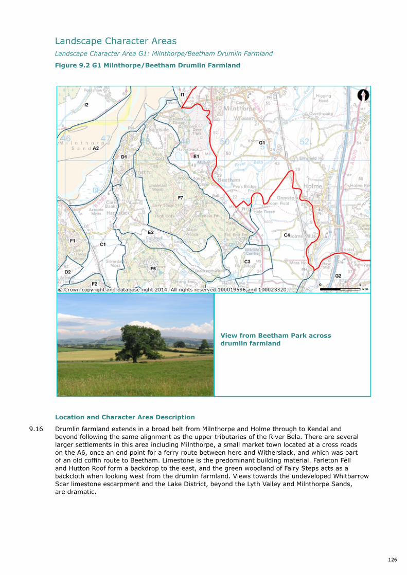
Location and Character Area Description
9.16 Drumlin farmland extends in a broad belt from Milnthorpe and Holme through to Kendal and beyond following the same alignment as the upper tributaries of the River Bela. There are several larger settlements in this area including Milnthorpe, a small market town located at a cross roads on the A6, once an end point for a ferry route between here and Witherslack, and which was part of an old coffin route to Beetham. Limestone is the predominant building material. Farleton Fell and Hutton Roof form a backdrop to the east, and the green woodland of Fairy Steps acts as a backcloth when looking west from the drumlin farmland. Views towards the undeveloped Whitbarrow Scar limestone escarpment and the Lake District, beyond the Lyth Valley and Milnthorpe Sands, are dramatic.
Landscape Character Areas LandscapeCharacterAreaG1:Milnthorpe/BeethamDrumlinFarmland
Figure 9.2 G1 Milnthorpe/Beetham Drumlin Farmland
144
9.15 For all these reasons, the Drumlin Farmland Landscape Character Type is considered to have a moderate - high level of inherent sensitivity. As a result, overall capacity to accommodate change without compromising the key characteristics of the Drumlin Farmland Landscape Character Type is considered to be limited.
Landscape Character Areas
Landscape Character Area G1: Milnthorpe/Beetham Drumlin Farmland
Figure 9.2 G1 Milnthorpe/Beetham Drumlin Farmland
Location and Character Area Description
9.16 Drumlin farmland extends in a broad belt from Milnthorpe and Holme through to Kendal and beyond following the same alignment as the upper tributaries of the River Bela. There are several larger settlements in this area including Milnthorpe, a small market town located at a cross roads on the A6, once an end point for a ferry route between here and Witherslack, and which was part of an old coffin route to Beetham. Limestone is the predominant building material. Farleton Fell and Hutton Roof form a backdrop to the east, and the green woodland of Fairy Steps acts as a
Picture 9.2 View from Beetham Park across drumlin farmland
View from Beetham Park across drumlin farmland
126

Location and Character Area Description
9.17 Drumlin farmland extends east of the AONB in a wide belt, strongly orientated north-northeast to south-southwest. This area is largely located east of the Yealand Villages and the Lancaster Canal, railway and A6/M6 corridor, but some drumlins extend west as far as the railway. Small villages are located at the intersection of the lanes which wind and ‘roller coaster’ through the area. Drumlins are divided into fields by clipped hedgerows, which give the appearance of having been draped over them. The upland limestone escarpment at Hutton Roof is a distinctive backdrop to the area to the east, with the woodland at Cringlebarrow and Warton Crag forming a softer backdrop to the west.
LandscapeCharacterAreaG2:BorwickDrumlinFarmland
Figure 9.3 G2 Borwick Drumlin Farmland
145
backcloth when looking west from the drumlin farmland. Views towards the undeveloped Whitbarrow Scar limestone escarpment and the Lake District, beyond the Lyth Valley and Milnthorpe Sands, are dramatic.
Landscape Character Area G2: Borwick Drumlin Farmland
Figure 9.3 G2 Borwick Drumlin Farmland
Location and Character Area Description
9.17 Drumlin farmland extends east of the AONB in a wide belt, strongly orientated north-northeast to south-southwest. This area is largely located east of the Yealand Villages and the Lancaster Canal, railway and A6/M6 corridor, but some drumlins extend west as far as the railway. Small villages are located at the intersection of the lanes which wind and ‘roller coaster’ through the area. Drumlins are divided into fields by clipped hedgerows, which give the appearance of having been draped over them. The upland limestone escarpment at Hutton Roof is a distinctive backdrop to the area to the east, with the woodland at Cringlebarrow and Warton Crag forming a softer backdrop to the west.
Picture 9.3 View from Yealand Conyers towards Borwick
View from Yealand Conyers towards Borwick
127
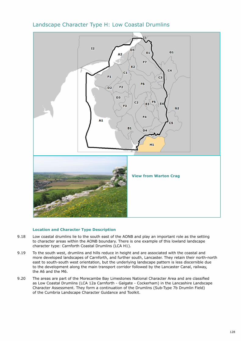
Location and Character Type Description
9.18 Low coastal drumlins lie to the south east of the AONB and play an important role as the setting to character areas within the AONB boundary. There is one example of this lowland landscape character type: Carnforth Coastal Drumlins (LCA H1).
9.19 To the south west, drumlins and hills reduce in height and are associated with the coastal and more developed landscapes of Carnforth, and further south, Lancaster. They retain their north-north east to south-south west orientation, but the underlying landscape pattern is less discernible due to the development along the main transport corridor followed by the Lancaster Canal, railway, the A6 and the M6.
9.20 The areas are part of the Morecambe Bay Limestones National Character Area and are classified as Low Coastal Drumlins (LCA 12a Carnforth - Galgate - Cockerham) in the Lancashire Landscape Character Assessment. They form a continuation of the Drumlins (Sub-Type 7b Drumlin Field) of the Cumbria Landscape Character Guidance and Toolkit.
146
Landscape Character Type H: Low Coastal Drumlins
Location and Character Type Description
9.18 Low coastal drumlines lie to the south east of the AONB and play an important role as the setting to character areas within the AONB boundary. There is one example of this lowland landscape character type: Carnforth Coastal Drumlins (LCA H1).
9.19 To the south west, drumlins and hills reduce in height and are associated with the coastal and more developed landscapes of Carnforth, and further south, Lancaster. They retain their north-north east to south-south west orientation, but the underlying landscape pattern is less discernible due to the development along the main transport corridor followed by the Lancaster Canal, railway, the A6 and the M6.
9.20 The areas are part of the Morecambe Bay Limestones National Character Area and are classified as Low Coastal Drumlins (LCA 12a Carnforth - Galgate - Cockerham) in the Lancashire Landscape Character Assessment. They form a continuation of the Drumlins (Sub-Type 7b Drumlin Field) of the Cumbria Landscape Character Guidance and Toolkit.
Picture 9.4 View from Warton Crag
Landscape Character Type H: Low Coastal Drumlins
View from Warton Crag
128

Key characteristics
The key characteristics of the Low Coastal Drumlin type within Arnside & Silverdale AONB are:
• Low north-north east to south-south west orientated drumlin and hill landforms extending south along the coast of Morecambe Bay.
• The orientation, pattern, small to medium scale and ‘egg shape’ of the drumlins.
• The distinctive hedges and walls and their relationship with the drumlin forms.
• Development focussed along the transport corridor of the Lancaster Canal, railway, A6 and M6, with towns such as Carnforth being historic ‘railway’ towns.
• Coastal farmland, generally ‘improved’, is interspersed with frequent campsites and caravan parks.
• Towns are of mixed character, having extended from their original stone built nucleated forms to encompass modern and industrial development.
• Drumlins are used for housing estates or comprise rolling agricultural land enclosed by trimmed hedges or in places limestone walls.
• The coastal strip affords panoramic views over the tranquil low lying open estuary of Morecambe Bay, with industrial features such as Heysham Power Station present in views.
• The quarried face of Warton Crag forms a backdrop to views from Warton.
Evaluation Valuedattributes
9.21 Key values of the Low Coastal Drumlins:
• Industrial heritage of the iron and steel industry, and its remaining influence on the local landscape and townscape of Carnforth;
• Expansive views across Morecambe Bay and towards the hills of the AONB;
• Visitor appeal of historic railway and vintage trains at Carnforth; and,
• Historic interest and recreational opportunities along the Lancaster Canal.
Current Landscape Condition
The overall condition of the Low Coastal Drumlins Landscape Character Type is considered to be moderate. The extensive areas of the town of Carnforth lends a more developed character than the Drumlin Farmland character type. The distinctive ‘grain’ of the drumlin’s orientation is evident although less prominent than that found in the drumlin farmland. Some areas within Carnforth are in need of renewal and there is evidence of missing and neglected hedgerows, poorly maintained over mature field trees, poorly maintained limestone drystone walls and loss of landscape features along the motorway/West Coast Main Line transport corridor.
Sensitivity and Capacity for Change
The Low Coastal Drumlins Landscape Character Type is considered to have moderate - high visual sensitivity overall, as a result of the intervisibility with the Arnside and Silverdale AONB, Hutton Roof, and the Lake District. From elevated parts of the drumlins visibility across the landscape to these distinctive features is good although hedgerow trees and copses limit views from many areas. The moderate - high ecological sensitivity is represented by the combination of pasture, hedges, hedgerow trees and river/canal/brook corridors. There is a rich industrial – especially railway – heritage within Carnforth which, in conjunction with the distinctive drystone limestone walls and clusters of historic buildings in settlements results in a moderate – high cultural sensitivity.
For all these reasons, the Low Coastal Drumlins Landscape Character Type is considered to have a moderate - high level of inherent sensitivity. As a result, overall capacity to accommodate change without compromising the key characteristics of the Drumlin Farmland Landscape Character Type is considered to be limited.
129

Location and Character Area Description
9.22 To the south of the AONB, coastal drumlins and hills extend from Carnforth through Bolton-le-Sands to Lancaster. Carnforth is an historic railway town, situated at the junction of three major railway lines until the 1960’s, and the site of an ironworks until the 1920’s. This has affected the character of Carnforth, giving rise to the presence of features of industrial heritage including workers housing, slag heaps and quarries set within scenic surroundings.
9.23 These coastal drumlins and hills are lower and less dense than the drumlin farmland further north and east. The Forest of Bowland AONB provides a backdrop of moorland hills to the south east, beyond the Lune Valley. The area around Carnforth and following the Lancaster Canal, the railway, A6 and M6 transport corridor is developed, with a string of towns which merge into Lancaster, located on the higher ground above the coastal strip of intertidal flats and saltmarsh. A number of camping and caravan parks are located along the coast. Between the railway towns are areas of improved grassland in fields divided by hedgerows, draped over drumlins, such as Hunting Hill. The Lancaster Canal has historic interest and provides walking and cycling routes, and the Lancashire Coastal Way footpath follows the coast. A prominent quarry is seen on the skyline at Over Kellet and a wind farm is present at Caton Moor in the Forest of Bowland AONB.
9.24 Building materials are mixed, including both limestone from Warton Crag and sandstone from the Carboniferous rocks to the south east, as well as extensive areas of modern houses and industry.
Landscape Character Areas LandscapeCharacterAreaH1:CarnforthCoastalDrumlins
Figure 9.4 H1 Carnforth Coastal Drumlins
View across coastal drumlins to Carnforth from Warton Crag
148
For all these reasons, the Low Coastal Drumlins Landscape Character Type is considered to have a moderate - high level of inherent sensitivity. As a result, overall capacity to accommodate change without compromising the key characteristics of the Drumlin Farmland Landscape Character Type is considered to be limited.
Landscape Character Areas
Landscape Character Area H1: Carnforth Coastal Drumlins
Figure 9.4 H1 Carnforth Coastal Drumlins
Picture 9.5 View across coastal drumlins to Carnforth from Warton Crag
Location and Character Area Description
9.22 To the south of the AONB coastal drumlins and hills extend from Carnforth through Bolton-le-Sands to Lancaster. Carnforth is an historic railway town, situated at the junction of three major railway lines until the 1960’s, and the site of an ironworks until the 1920’s. This has affected the
130
Location and Character Type Description
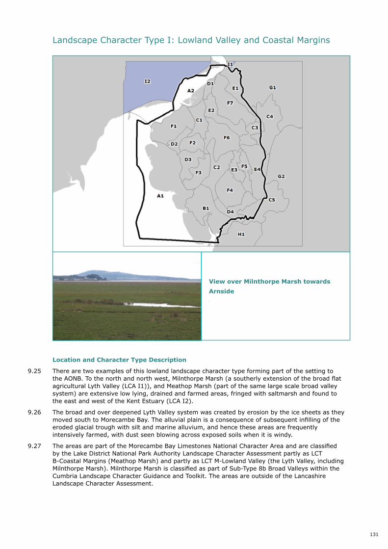
9.25 There are two examples of this lowland landscape character type forming part of the setting to the AONB. To the north and north west, Milnthorpe Marsh (a southerly extension of the broad flat agricultural Lyth Valley (LCA I1)), and Meathop Marsh (part of the same large scale broad valley system) are extensive low lying, drained and farmed areas, fringed with saltmarsh and found to the east and west of the Kent Estuary (LCA I2).
9.26 The broad and over deepened Lyth Valley system was created by erosion by the ice sheets as they moved south to Morecambe Bay. The alluvial plain is a consequence of subsequent infilling of the eroded glacial trough with silt and marine alluvium, and hence these areas are frequently intensively farmed, with dust seen blowing across exposed soils when it is windy.
9.27 The areas are part of the Morecambe Bay Limestones National Character Area and are classified by the Lake District National Park Authority Landscape Character Assessment partly as LCT B-Coastal Margins (Meathop Marsh) and partly as LCT M-Lowland Valley (the Lyth Valley, including Milnthorpe Marsh). Milnthorpe Marsh is classified as part of Sub-Type 8b Broad Valleys within the Cumbria Landscape Character Guidance and Toolkit. The areas are outside of the Lancashire Landscape Character Assessment.
Landscape Character Type I: Lowland Valley and Coastal Margins
150
Landscape Character Type I: Lowland Valley and Coastal Margins
Location and Description
9.25 There are two examples of this lowland landscape character type forming part of the setting to the AONB. To the north and north west, Milnthorpe Marsh, a southerly extension of the broad flat agricultural Lyth Valley (LCA I1), and Meathop Marsh, part of the same large scale broad valley system, are extensive low lying, drained and farmed areas, fringed with saltmarsh and found to the east and west of the Kent Estuary (LCA I2).
9.26 The broad and over deepened Lyth Valley system was created by erosion by the ice sheets as they moved south to Morecambe Bay. The alluvial plain is a consequence of subsequent infilling of the eroded glacial trough with silt and marine alluvium, and hence these areas are frequently intensively farmed, with dust seen blowing across exposed soils when it is windy.
9.27 The areas are part of the Morecambe Bay Limestones National Character Area and are classified by the Lake District National Park Authority Landscape Character Assessment partly as LCT B-Coastal Margins (Meathop Marsh) and partly as LCT M-Lowland Valley (the Lyth Valley, including Milnthorpe Marsh). Milnthorpe Marsh is classified as part of Sub-Type 8b Broad Valleys within the Cumbria Landscape Character Guidance and Toolkit. The areas are outside of the Lancashire Landscape Character Assessment.
Picture 9.6 View over Milnthorpe Marsh towards Arnside
View over Milnthorpe Marsh towards
Arnside
131
Key characteristics
The key characteristics of the Lowland Valley and Coastal Margin type within the setting of Arnside & Silverdale AONB are:
• Flat low lying patchworks of improved grass and arable land, often with straight ditches and or hedges or fences dividing fields.
• Linear ditches - sometimes reed lined, into rectilinear fields, and artificially drained by pumping water away.
• Overlooked by more settled landscapes on the higher fringes - the drumlins to the east and the Lake District Fells to the west.
• To the west of the Kent Estuary, outlying low wooded hills (Meathop Fell, Ulpha Fell) with some historic settlement and an irregular field pattern are ‘islands’ in the marsh.
• Extensive areas of lowland raised bog such as at Foulshaw Moss.
• Straight rural lanes with hedgerows.
• The Cumbria Coastal Way follows the marsh edges.
Evaluation Valuedattributes
9.28 Key values of the Lowland Valley and Coastal Margins:
• Large scale, agricultural landscape with a regular field pattern;
• Visual link with the Kent Estuary;
• Forms an unobtrusive foreground in views to the AONB and surrounding hills of the Lake District, Yorkshire Dales and Howgill Fells; and,
• Exposed, wind-swept character.
Current Landscape Condition
The overall condition of the Lowland Valley and Coastal Margin Landscape Character Type is considered to be good. Most of the landscape features are generally well managed – many of the field boundary hedges have a neat clipped appearance. There is however limited evidence of neglected or lost hedgerows and subsequent infilling with fencing.
Sensitivity and Capacity for Change
The Lowland Valley and Coastal Margin Landscape Character Type is considered to have high visual sensitivity overall, as a result of the intervisibility with the Kent Estuary, Arnside and Silverdale AONB and surrounding hills of the Lake District, Yorkshire Dales and Howgill Fells. The high ecological sensitivity results from the habitat diversity of drainage channels, marsh, lowland raised bog, coniferous and broadleaved woodland, hedgerows, hedgerow trees and copses. Overall cultural sensitivity is considered to be moderate resulting from scattered traditional historic farms and irregular field patterns. There is an element of relative newness to the landscape; the presence of flood walls and drainage ditches all suggest an agricultural landscape which has been reclaimed from the estuary.
For all these reasons, the Lowland Valley and Coastal Margin Landscape Character Type is considered to have a moderate - high level of inherent sensitivity. As a result, overall capacity to accommodate change without compromising the key characteristics of the Lowland Valley and Coastal Margin Landscape Character Type is considered to be limited apart from change which reinforces positive attributes such as habitat enhancements.
132
Location and Character Area Description
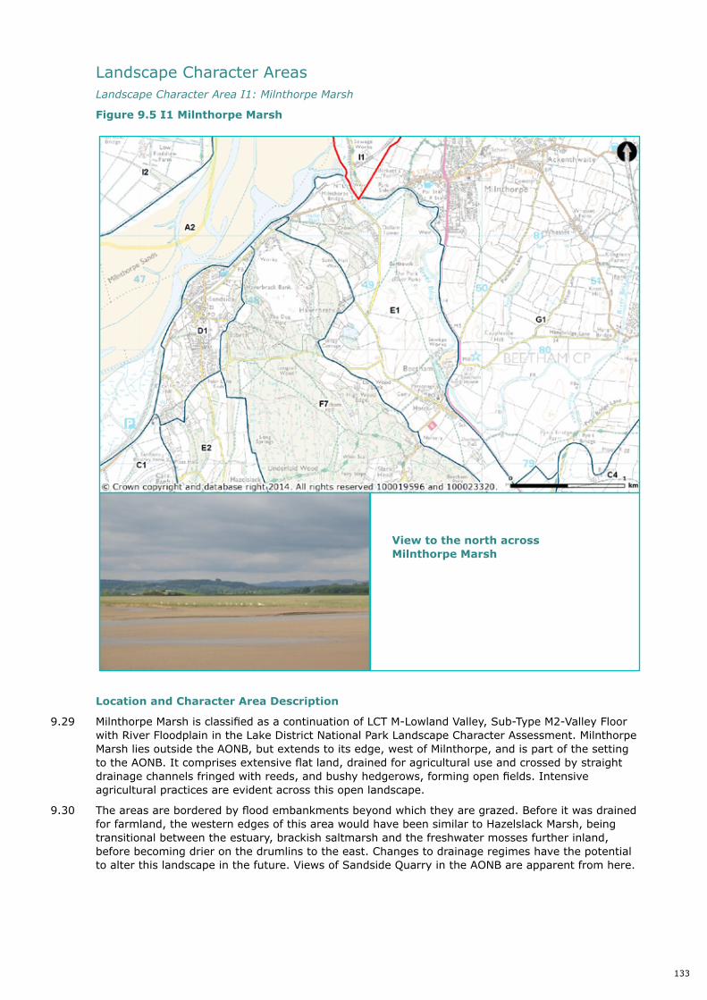
9.29 Milnthorpe Marsh is classified as a continuation of LCT M-Lowland Valley, Sub-Type M2-Valley Floor with River Floodplain in the Lake District National Park Landscape Character Assessment. Milnthorpe Marsh lies outside the AONB, but extends to its edge, west of Milnthorpe, and is part of the setting to the AONB. It comprises extensive flat land, drained for agricultural use and crossed by straight drainage channels fringed with reeds, and bushy hedgerows, forming open fields. Intensive agricultural practices are evident across this open landscape.
9.30 The areas are bordered by flood embankments beyond which they are grazed. Before it was drained for farmland, the western edges of this area would have been similar to Hazelslack Marsh, being transitional between the estuary, brackish saltmarsh and the freshwater mosses further inland, before becoming drier on the drumlins to the east. Changes to drainage regimes have the potential to alter this landscape in the future. Views of Sandside Quarry in the AONB are apparent from here.
Landscape Character Areas LandscapeCharacterAreaI1:MilnthorpeMarsh
Figure 9.5 I1 Milnthorpe Marsh
152
Landscape Character Areas
Landscape Character Area I1: Milnthorpe Marsh
Figure 9.5 I1 Milnthorpe Marsh
Location and Character Area Description
9.4 Milnthorpe Marsh is classified as a continuation of LCT M-Lowland Valley, Sub-Type M2-Valley Floor with River Floodplain in the Lake District National Park Landscape Character Assessment. Milnthorpe Marsh lies outside the AONB, but extends to its edge, west of Milnthorpe, and is part of the setting to the AONB. It comprises extensive flat land, drained for agricultural use and crossed by straight drainage channels fringed with reeds, and bushy hedgerows, forming open fields. Intensive agricultural practices are evident across this open landscape.
9.5 The areas are bordered by flood embankments beyond which they are grazed. Before it was drained for farmland, the western edges of this area would have been similar to Hazelslack Marsh, being transitional between the estuary, brackish saltmarsh and the freshwater mosses further inland, before becoming drier on the drumlins to the east. Changes to drainage regimes have the potential to alter this landscape in the future. Views of Sandside Quarry in the AONB are apparent from here.
Picture 9.7 View to the north across Milnthorpe Marsh
View to the north across Milnthorpe Marsh
133

Location and Character Area Description
9.31 Meathop Marsh is classified as LCT B-Coastal Margins, Sub-Type B2-Coastal Mosses in the Lake District National Park Landscape Character Assessment. The area lies outside the AONB, but extends up to its north western edge. It extends as a low lying and flat to gently undulating expanse of agricultural land along the north west side of the Kent Estuary. It has largely been drained for agriculture, like Milnthorpe Marsh. Some areas were planted with coniferous plantation forest, such as Foulshaw Moss, but extensive tree removal to restore lowland raised bog has now been carried out. Natural wet woodland (carr) occurs at Meathop Moss. The area is criss-crossed by a network of drainage channels which drain the marsh. Islands on the marsh are created from higher ground which is well wooded and divided into irregular shaped fields, with scattered traditional historic farms.
LandscapeCharacterAreaI2:MeathopMarsh
Figure 9.6 I2 Meathop Marsh
153
Landscape Character Area I2: Meathop Marsh
Figure 9.6 I2 Meathop Marsh
Location and Character Area Description
9.6 Meathop Marsh is classified as LCT B-Coastal Margins, Sub-Type B2-Coastal Mosses in the Lake District National Park Landscape Character Assessment. The area lies outside the AONB, but extends up to its north western edge. It extends as a low lying and flat to gently undulating expanse of agricultural land along the north west side of the Kent Estuary. It has largely been drained for agriculture, like Milnthorpe Marsh. Some areas were planted with coniferous plantation forest, such as Foulshaw Moss, but extensive tree removal to restore lowland raised bog has now been carried out. Natural wet woodland (carr) occurs at Meathop Moss. The area is criss-crossed by a network of drainage channels which drain the marsh. Islands on the marsh are created from higher ground which is well wooded and divided into irregular shaped fields, with scattered traditional historic farms.
Picture 9.8 View over Meathop Marsh towards Arnside
View over Meathop Marsh towards Arnside
134