91-17566 - defense technical information center · abstract coup d'oeil: military geography...
TRANSCRIPT

-AD-A243 343 .- -=
Coup d'O;6ii:Military Geography and The Operauona! Level 3f War
A Monograph DEC 1 3L
I Major John O'Brien C
Infantry
$t T OM '
91-17566
School of Advanced Military StudiesUnited States Army Command. and General Staff College
SFort Leavenworth, Kansas
Second Term 90-91
Approved toe Public Role***; Distribution Is Unlimited
Reproduced From
Best Available Copy
91. 1210 082i ' • 2Q90 'xc oo 0 7.... •.....4 •l ... • ... •""............

UNCLASSIFIEDSECURITY CLASSIFiCATION Of TH'S AGE
I Form Approved
REPORT DOCUMENTATION PAGE OMB No o0o.7.o!88IEp Dare Jun.30. 1986
la. REPORT SECURITY CLASSIFICATION lb. RESTRICTIVE MARKINGS
Unclassified _
2a. SECURITY CLASSIFICATION AUTHORITY 3. DISTRIBUTIONIAVAILABILITY OF REPORiApproved for public release;
2b. DECLASSIFICATION/I DOWNGRADING SCHEDULE Distribution is unlimited
4. PERFORMING ORGANIZATION REPORT NUMBER(S) S. MONITORING ORGANIZATION REPORT NUMBER(S)
6a. NAME OF PERFORMING ORGANIZATION |6b. OFFICE SYMBOL 7a. NAME OF MONITORING ORGANIZATION
School of Advanced Military I (If applicible)
Studies j ATZL-SWV
6c. ADDRESS (City, State, and ZIPCode) 7b. ADDRESS(Cit, State, and ZIP Code)
Fort Leavenworth, KS 66027-6900COM (913) 684,-3437 AUTOVON 552-3437
Ba. NAME OF FUNDING/SPONSORING 8 b. OFFICE SYMBOL 9. PROCUREMENT INST3UMENT IDENTIFICATION NUMBERORGANIZATiONI (If applicable)
8c. 4.DDRESS (City, State, and ZiP %.ode) 10. SOURCE OF FUNDING NUMBERSPROGRAM PROJECT ITASK IWRK UNITELEMENT NO. NO. NO. ACCESSION NO
11. TITLE (include Security Classification)
Coup d'Oeil: Military Geography and the Operational Level of War (U)
12. PERSONAL AUTHOR(S)
O'Brien, John J., Major
13a. TYPE OF REPORT 13b. IIME COVERED 14. DATE OF REPORT ( Year, Month, Day) 15. IAGE COUNTMonograph FROM TO 91-5-16 61
16. SUPPLEMENTARY NOTATION
17. COSA'I CODES 18. SUBJECT TERMS (Continue on reverse it necessary and identify by block number)FIELD GROUP SUB-GROUP MILITARY GEOGRAPHY TERRAIN INTELLIGENrE
MILITARY OPERATIONSMILITARY PLANNING
19. ABSTRACT (Continue on reverse if necessary and identify by block number)This mokiograph focuses on the geographic component of the contemporary intelligence processat the operational level of war. The concept of cqu_ deeil, the intellectual capacity ofmilitary commanders to evaluate geography and apply thai?"avaluation to the successful pro-secution of war, serves as the unifying theme throughout the monograph. The research ques-tion is to examine how to better the c• d of the commander at the operational level.
The theoretica nature of c2up d'oeis examined to establish the basis of the relation.ship between geography and warm'are.-' (d&LtC 1'e
Missing at the operational level is a methodology to analyze quickly, accurately andappropriately, the key elements of terrain in the theater of operations.
The monograph suggests that access, mobility, visibility, communicability, availability,•' and vulnerability are the appropriate elements of operational terrain analysis. 'Eperation
p " une " and the subsequent break out from the Normandy beachhead is used as a historicalcase study to examine these elements in support of a campaign design. e__
20. DISTRIBUTION/AVAILABILITY OF ABSTRACT 21. ABSTRACT SECURITY CLASSIFICATIONSUNCLASSIFIED/UNLIMITED C3 SAME AS RPT. 0 OTIC USERS 'Unclassified
22a. NAME OF RESPONSIBLE INDIVIDUAL 22b. TELEPHONE (Ilude A.e Code) I22c. OFFICE SYMBOL
DO FORM 1473.84 MAR 83 APR edition may be lsed until exhauited. SECURITY CLASSIFICATION OF THIS PAGEAll other~editir,ns are obsolete. URCLASSIFIT
UNCLASSIFIED

SCHOOL OF ADVANCED MILITARY STUDIES
0.ONOGRAPH APPROVAL
Major John J. O'Brien
Title of Monograph. Coup d'Oeil: Military Geography and
the Operational Level of War.
Approved by:
eS k•'S rw Monograph DirectorLT (IP) John D. Skelton, MPA
A •Director, School ofCO Jame's R. McDonouý, MS Advanced Military
_________ ..... _Director, GraduatePhilip J. Brookes, Ph.D. Degree Program
Accepted this / uday of 1991
SAvoL1atbI3Jý Cosil
4 j.wall and/orD13t . I. l
fit. Sasa

ABSTRACT
COUP D'OEIL: MILITARY GEOGRAPHY AND THE OPERATIONAL LEVEL OFWAR by MAJ John J. O'Brien, USA, 58 pages.
This monograph focuses on the geographic component of thecontemporary intelligence process at the operat±onal level ofwar. The concept of coup d'oeil, the intellectual capacityof military commanders to evaluate geography and apply thatevaluation to the successful prosecution of war, serves asthe unifying theme throughout the monograph. The researchquestion is to examine how to better the coup d'oeil of thecommander at the operational level-'of war .
The theoretical nature of coup d'oeil is examined toestablish the basis of the relationship between geography andwarfare. Recognizing that the classical theorists based theirtheories on the model of the Napoleonic campaign, a comparisonis made between- Napoleonic strategy and modern operational art.The salient difference between the two is that whereas Napoleonicstrategy sought to bring all resources against the decisivepoint at the decisive time in one decisive battle, operationalart is extended in time and in space beyond one decisive battle.The operational commander sets conditions for tactical executionby his subordinates, while at the same time planning to exploitthe new conditions established by tactical results.
The changing international security paradigm brought onby the collapse of Communism in the 1980s and 1990s suggeststhat the most likely future role of United States Forces willbe one of regional crises response. Highlighted 'in the newparadigm is the increasing role of the operational level ofwar commander. Though he has a methodology for campaign design,missing at the operational level is a methodology to analyzequickly, accurately and appropriately, the key elements ofterrain in his theater of operations.
An organized application of geographical informationappropriate for the operational level of war must not be sodescriptive as to be useless, nor should it be restricted tothe rather specific and local elements of tactical. terrainanalysis. The monograph suggests that access, mobility,visibilityr communicability, availability, and vulnerabilityare the appropriate elements of operational terrain analysis."Operation Neptune" and the subsequent break out from theNormandy beachhead is used as a historical case study to examinethese elements in support of a campaign design.
V+

TABLE OF CONTENTS
Introduction ....................... I
The Nature of Coup d'oeil ............... 5
The Exercise of Coup d'oeil....................... 10
Classical Coup d'oeil vs. Operational Ccup d'oeil. 15
The Current State of US Operational Coup d'oeil... 20
Suggested Key Elements for Operational LevelTerrain Analysis ..... 29
Operational Coup d'Oeil in"Operation Neptunev '....... 33
Conclusion .................. . *....*... 40
ANNEXES
A. CLASSICAL STRATEGY VS. OPERATIONAL ART ........ 42
B. LEVELS OF WAR ARE RELATED BUT DISTINCTIVE...'.. 43
C. CAMPAIGN PLAN FORMAT ................... 44
D. NORTHWEST EUROPE "UPSIDE DOWN"................ 45
E. COTENTIN PENINSULA ........ .. .. 46
ENDNOTESe*e*,'e,,, 47BIBLIOGRAPHY ................................... 55So @@ •o eo o oo eo oe oo o @• •o @oV
The focus of this mnoxgraph is to examine the geographic component ofthe ccnX.At intelligence process at the operational level of war. The
French term "coup d'oeil" (an eye for the ground), coined by Frederick theGreat, appears to symbolize the intellectual capacity of military commandersto evaluate geography and apply that evaluation to the successful prosecuticln
of war. Cow d'oeil, as a term used by the classic-ii theorists, has never
been limited to merely "geography" as we may have understood the_ tenn frou
ouir grade school experience where "geography" may have meant 'the memorization
of terms such as "island", and "peninsula". Cow d'oeil views geography
as the relationship among what a commander can do with the ground, whathis opponent can do with the ground, and how they will interact cn the
grmd. (1)Geogra and war have long been bedfellows. At the Battle of Megiddo,,
1479 B. C., the Eygptian Pharaoh, Thutmose III, "was advised by a staffof the location and intentions of the enemy and of the terrain to his frcnt."(2) War occurs on or near the surface of the earth; geography is the sciencewhich seeks to describe what is on or near the surface of the earth. A comonuthem throughout military history is that the .1.1arder who better understandsall that the geography of the battle area implies, and uses it to hisadvantage, is the camnmader most likely to win the battle.
There are many ways to describe the science of geography. In its mostbasic form it is a descriptive science. It may be crudely described as"What's where? Why? (and so what?)." (3) Geog y in its philosophical
and most general sense constitutes the study of emp~irical kzauledge fromthe viewpoint of the spatial distribution of phenomena on or near the surfaceof the earth. (4) Mdern geogra has becmeore than merely a descriptivesciem. It can have an interpretative and progrxxstic nature too. Whilegeography commonly deals with the visible landscape, it is, interested inall those factors which give personality to a place. (5)
MVny lengthy studies have been undertaken in an attempt to validatea sub-discipline of "military geography" within the larger body of geographyproper. (6) Whether or not there is a legitimate sub-discipline of military
V geography within the science of geography is a debate internal to the
cmmunity of geographrs.. What is evident without debta t owever, is that
17

geography it a. related discipline of military art and science. Iraditionally,
this application has resided in the field of military intelligence. "Military
geography and military intelligence are fields so closely related that
confusion frequently exists as how ame differs fran the other." (7)
1,he thee traditiraal manifestations of. geography in military
intelligence are environmental studies, regional studies, and terrain
analysis. 11ircýMental studies provide systenic data about climate and
conditions which affect the development and procur--ent of equipment,
logistics, organization, and doctrine. Regional studies provide descriptive
and interpretative information about landscape. infrastr~trtre, culture,economics, sociology, and political structure of a geographic area. Terrain
analysis makes use of map studies. The broad categorizations of map studies
are geographic studies, chorographic studies, and topographic studies.Military art and science addresses the same general categories by the names
of strategic analysis, theater analysis, and topographic analysis. These
military categories reflect not only scale, but levels of war at the
strategic, operational, and tactical level.
Figure 1 illustrates the ccmito , conceptual framework forunderstanding how geographic ,cience is integrated into the overallintelligence effort. The framework attemptc to capture the relationship
between friendly and enexy forces in the operatirn envirgnnent.
THRJ E-TEVALUTICN
32rFl.ThLL )GRAPHiYThRA
- cablit 1 ie3 - Regional StudiesIntentJo•w ANALYSISoTE, TE-ta
CF THEni~ LY I TME -Enviroimentcal
- Vulnerabilities CHARACTRISTICS.-SCP THE-Map Studies
FIQGMR 1 (The Intelligence Process) (8)
2

7e internal rings identify the components of the intelligence process
at the operaticnal level of war. The middle ring identifies a continuous
process of Analysis-Evaluatiun-Analysis as new information is received and
the situation develops. The external ring identifies the continuous
relationship betwen georaphic infrati and intelligence information.
The integration of moder intelligence gathering technology and modern
techniques of terrain analysis derived from the science of geography have
resulted in a tT-mendously powerful analytical tool called "Intelligence
Preparation of the Battlefield" (IPB). At the tactical level. this tool
produces for the commnder and staff a set of graphic prrxucts which could
nearly be called "visual tactical coup d'oeil".
As the IPB process wes being introduced in the early 1980s to the
tactical level of the US Army, a doctrinal debate was occurring at the seniorlevel of Army leadership concerning the reintrcd ctien of the operationallevel of war or "operaticral art" into Army doctrine. As both conceptsmatured, attempts to apply the IPB process to the operatiznl level of warhave generally proven unsatisfactory.. (9) Tftere remains therefore, atremendous void about how to best support the operational level camwrwith an equivalent and appropriate lavel of intellig e suplt. Thequestion to be pursued in this vmnxgraph will be to examine if a betterundestaringof the geographic component of operaticral intelltgence canhelp to fill this void.
'Ie concept of c d'oeil defined as the intellectual capacity ofmilitary cim-nd•ers to evaluate geography and aply that evaluation to theruocessful prosecution of wr, will serve as the unifying theme throughout
this mnxograph. 'fla Methiodology will be to first explore the theoreticalnature of c d'oeil. Te second step will be to carry the concept forwrd
as evidenced in the Intelligence Preparaticxl of the Battlefield (IPB)' process.The third step will be to acamine the dWiing iu$re of wr and the rewinternatioal security paradigm of the post Old War world. This thirdsteop in the examination highlights the increasing visibility of theoperational level of war as distirguished frcm tha strategic level of war
and the tactical level of war.With a clear distinction uchd. between the strategic and operational
levels of war, I will sugest the elements of oprational level of war coup
d' which will satisfy the research question. "Operaticn Neptn", the
3

invasion of Normandy, C June 1944, will b. used as a historical example
to analyze the effectiveness of the proposed eleffnts of operational coap
d'oeil. 'Neptune" prcvides an excellent case study first because of the
clear distinction between the strategic and operational levels of war,
and seonly because of the tremendous influence of geography in the plarming
By definition, opErational axt involves fundamertal deciE ions about
when and where to fight and whether to accept or decline battle. At the
operational level of war the cmmander must discern the answers to three
fundamntal questions: what ccdtiors must be produced to achieve the
strategic goal; what sequence of actions is most likely to produce that
condition; and how should rescou1xs of the force be applied to accomplish
that sequence of actions. (10) Any criteria to assess the degiree of
assistance geography might add to the cziuunder's coup d'oeil w st paralJel
this design. The criteria for this assessment will be:
1) Military geography must be able to assist the cander
to envision the military end state, where his forces must .
be at the conclusion of the event which attains the
desired end state.
2) Military geography must be ab e to assint the catmander
to envision a sequence of events in, t.a medium of time,
sce, and mass which gets h s forces to the desired end
state.
3) Military ggraphy must be able to assist the c:mmiander to
envision how to apply reo--Arcis, operational and logistical,
Whi• h will carry the force thzoxff the sequence of events
with sufficient strength to eve the desired end state.
With this criteria in Wnd, we will with an exploration of the
teoretical relationship bet , warfare a geography by examining the nature
of M d'oeil.
4

¶.YnE •i!JRE CF afUP D'OEIL
Every day I feel nmre rnd more in need of anatlas, as geogrphvy iv the minutest details.is essential to a true nli "tary education. Iwish therefore, you *-xld proure me the bestgeography and atlas exc•nt. (0)
f•n. William T. Sherman
Lieutenant William T. Sherman requested the '"est geography and atlas
txtant" from his scon to be brother-in-law in the year 1844. In the yearsprior to the American Civil War, Lieutenant Sherman was asaigned to FortHultrie, South Carolina. On this terrain, over which he was to lead a
Unick army twenty years later, Lieutenant Sherman developed what was to
become an exceptionaily keen sense of military geog-aphy. His biographerwrote of these years: "the details of the ground were fixed in his memoryon lcr-g horseback rides zhat he took alone... it was his habit, almost hispassion, to study the slopes, curves, and stretches of terrain... a habit
born of a singular fondness for the earth." (2)Military geographers cite the habits of this famous Unicn general as
an example of the utility which geography can provide to a military leader.
(3) Past masters of the milita-y art have likewise reflected the primacyof a practical knowledge of the science' of geography as a fundamental skillof genaralship. Frederick the Great stated in his Instructions: "Krowledge
of a country is to a general what a rifle is to an infantryman and what therules of arithmetic are to a gecsetrician". (4) Napoleon, whose actions
spoke with nxb~ nr 3 clarity than his written maxims, was exctrseiely thoroughin his planning. "As som as the possibility of a war arose, the &perorwould send for Ids librarian and demand a cpehensive series of books -
historical, descriptive, .sgeographical, and topi•cal - which he would read...building up a clear mental picture of his future opponent." (5) Awarenessof the cmtrality of geography to the military art vetends to our currentUnited States Army doctrine with the simple statement found in FM 100-5(OPeratics), '%vuerstanding the limitations and opportunities of terrainis a fundammtal nilitary skill." (6)
Geographers have said the soldier uses geography uncmsciously, withouteven realizing that he is doing so. (7) Some however, do better than others.Skillful use of geography applied to a military purpose was termed coup d'oeil
'' ' '5

by Itexerick the Great. He dei.iaed cow d'oei. of a genera). as, "the talent
which great men have of conceiving in a moment all tha advantages of the
terrain and ':he use they can make of it with their armwy." (81 Fc'aderick
furtlter ref ined his definition to include three key elements. First, it
is a Judgment about, "the ground you can occupy with a certain numrber of
troops". Second, it is a "perception of the advantages of terr-in".
Third, judgmant "is exercised about the capacity of the ..... ". (9)
The term cm d'oeil continiued to have a grographic coixntation about
the comnander's judgment and perception of the inter-action of opposing forces
on terrain. •"Le term Pppeare& frequently in 19th Century military theory.
Brcn Antoine Henri Jamini, whose theory of war depended so greatly on
striking the decisive- point with a coordinated massing of overwhelming force,
referred to a failure to recognize this point as possibly a "defective coup
d'oeil militaire". (10) Jcmiri highlighted that, "if a general desires
to be a successful actor in the great drama of war, his first duty is to
study carefully the theater of operaticns so that he may see clearly the
relative advantages and disadvantages it presents for himself and his
enemies." (11) Th study carefully the theater of operations implies a heavy
emphasis on a study of the geography of the theater. Geography alone hoever,is not coup d'oeil. It is possible to understand all that can be known abcat
the strategic situation, yet fail to subdue the opponent. Coup d'oeil is
fcxini in the application of military force across the geography of the theater
to achieve the desired st:ategic end state. If the general be "not possessedof military coup d'oeil, he may make an excellent strategic plan and be
entirely unable to apply the rules of tactics in the presence of an enemy."
(12)
Carl yon Ciausewitz rccoqnized coup d'oe:l as "an indispensable quality"
of the general.
If the mind is to emerge unscathed fran thisrelentless struggle with the unforeseen, twoqualities are indispensable: first, an intellectthat, even in the darkest hour retains soe_gliimrings of the. inner light which leads totnrth; and sec=d, the courage to follow thatfaint light wherever it may lead. The first isdescribed by the French term coup d'oeil. the secondis determination. (13)

Clausewitz began his discussion of coup d'oeil by describing it as "the
idea of a rapid and accurate decision... based on an evaluation of time and
space". He did differ with t!e reference of his day which limited oup d'oeil
to "visual estimates only." (14) He expanded the definition to include,"any sound decision taken in the midst of action - such as recognizing the
right point of attack, etc." (15) Clausewitz also added an operational
meaning to coup d'oeil because "it must also have its place in strategy,
since here as well quick decisions are often needed." (IA)
Clausewitz introduced his definition of coup d'oeil in a rather grandiose
literary style, "an intellect that even in the darkest hour -etains some
glimmerings of the inner light which leads to truth." As a result of cf
his literary style coup d'oeil is often taken out of context to mean something
more than what it .appears Clau•ewitz meant. When the metaphor is stripped
away nowvver, "the concept merely refers to the quicx recognition of a truth
that the mind would ordinarily miss or would perceive only after long study
and reflection." (17) Tha "truth" t- which he refers, is firmly linked to
tetrrain. Cow d'oeil is of the intellect. Determination is of the
tfaverament. "Determination, which dispels dcubt, is a quality that can
be aroused only by the intellect." (18) '"f the attributes that a great
oinmander needs in war, there is only one which is not relaced toteeger4amkt, and involves merely the intellect, "I mean the relationship
between warfare and terxuain." (19)
Discussing the trap of falling victim to pure theory, Clausewitz again
resorts to his literwy style and suggests that a student of war should not,
"be irresistibly dracged don to a state of dreary pedantry and.4ub aroundin the underwrld c,( ponderous concepts where no great ccmuander, with hiseffortless .d!--,eil wDs ever see." (20) n the more direct language
he used to emphasize a point, Clausewitz sums up his regard for this quality
by stating in the introduction to h.- final dcapter of Cnk War (Book 8: 'War
Plans), "when all1 is said and &wieo it is really the owcinader 's coud'oeil his ability to see things simply, to identify the whole business
of war completely with himself, that is the essence of good generalship."
(21)
Clausewitz, Frederick, Napoleon, and Jamini saw a centrality to thecataclysmic and decisive bat+le in warfare. Their theories are representative
of an attrition oriented apj..dch to battle. By omtrast, a maneuver
7

oriented approach to battle has been articulated and represented by thecrists
such as B. H. Liddel Hart and William S. Lind. (22) The roots of Liddel
Hart's "indirect approach", and Lind's 'ýmaneuver warfare", lie with the
great Chinese philosopher of war, Sun Tzu.
Sun Tzu, who wrote around 500 B.C., never used the French term coup
d'oeil. He-did however, articulate the same concept. Samual B. Griffith,the translator and c- nentator of Sun Tzu's, The Art of War, observes of
the Chinese culture, "The Chinese have always had a special feeling fornature. This is reflected in their painting, history, poetry, and otherliterature. Possibly the ability of their great soldiers to use terrain
to best advantage derives from this apparently innate appreciation of it."
(23)Sun Tzu identified five elements of the art of war. These were the
measurement of space, estimates of quantities, calculations, comparisons,
and chances of victory.
b•asets of space are derived from the ground....Quantities derived form measurement, figures fromquantities, comparisons from figures, and victoryfrom c a o... 'Ground' includes both distanceand type of trra.in; 'menasuraent' is calculation.Before the army is dispatched, calculations are maderespecting the degree of difficulty of th enemy'sland; the directness and deviousness of its roads:the mniber of troops; the quantity of his war equipmentand the state of his moral. (24)
In Sun T¶zu's conception, the elements of war make up a relationship.The relationship is between calculations about the enemy, calculations aboutthe march, and calculations about the terrain on which the battle is tobe fought. "A genral who is ignorant of ev one of these matters is unfit
for oummand." (25)The nature of coup d'oeil, as-has been described by the theorists,
is that of a quality of the intellect. It is an intellectual quality reuiredof the general. This quality of the intellect enables the general to appraisethe ftvW, to appraise the advantages and disadvantages of a piece of
terrain, and to visualize the time-space relationship between'the opposingforces. *Frerick and Clausewitz imply this quality is an individual talentresulting from training. Janini and Sun Tzu imply the quality results frcmMuthOdical calculaticn cnducted by the cammde and a. staff.,, All the
8 •-~

theorists agree however, that coup d'oeil as has been defined, is afundamental quality of the superior general.
j9

THE EXaCISE OP COUP D'OEIL
Twenty years after requesting an atlas and geography from his
brother-in-law, General William T. Sherman submitted an extraordinary
dispatch fran Savannah, Georgia, to General U.S. Grant. Qancerning the
progress of his March to the Sea". General Sherman wrote:
I think our campaign of the last month, as wallas every step that is taken fran this point north-ward, is as much a direct attack upon Lee's armyas though we were operating within the sound ofhis artillery. (1)
Sherman's dispatch was extraordinary because it captured in a sentence
the embryonic notion of the evolution of warfare frca. classic Napoleonicstrategy to what we now call "operational art". (2) "Sherman, with Grant'sactive involvement, gave the most spectacular display of the growing searchfor an alternative [to static warfare) through strategic maneuver." (3)What was new about this form of warfare being waged by the generals of the
North was that,, "Sherman and Grant exploited diversion, dispersion, andsurprise to pursue successfully a modern total war strategy of exhaustion
against the enemy's resources, communications, and will. " (4) 7he effectof severing Lee's Army of Virginia from its industrial and logistics basedemonstrated operational coup d'oeil. Sherman's knowledge of the the terrainand geography of the South enabled him to avoid battle with ConfederateGeneral Joe JhnsMon while at the. same time allowing him to strike at key
targets within the infrastructure of the Southern States. The destructionof this infrastructure denied Lee use of the rail system, cut his linesof support, and broke the will of the Suthern populace to continue a losing
effort.Historian G. Murphy DIivan noted two great lessoas from the Civil War
appropriate to the study of operational art:
In the early years of the Civil War, Lincolnhad to fire his high cummanders after nearlyevery major battle. Good logisticians andenginrs (military scientists) were ouen enough,but Lincoln couldn't find cmmanders (militaryartists) who had e•qrience with or aptitude for,
S1')

the sucicessful orchestration of forces larger thandivision or corps... the second great lesson is thatwe keep forgetting this. (5)
Any reasonable history of the doctrinal debate which occurred in the
US Army between the 1976 edition of Field Manual 100-5 (operations), through
the 1982 and 1986 revisions of this capstone doctrinal manual, bears witness
to the depth of the efforts on t]e part of the Army's leaders to coe to
grips with the lessons of cperational art and the practice of the art at
the operational level of wr. Describing this revolution, Lieutenant Colonel
(now Colonel) L.D. Holder stated, "the adoption of operational art may be
the most important change in Army doctrine since World War II" (6) Holder
suggested, "senior officers will have to naster an important subject which
has been neglected for a generation.. they will Nave to overcome an
entrenched habit of thinking solely in tactical terms." (7)
'*Thinking solely in tactical terms" however, was not without merit.
Many significant advances in tactical technique and procedure were developed
while the day to day army was narrowly focused on "preparing for the nextbattle", a term which further highlights the intense tactical focus of
official doctrinal literature of the period. rhap one of the better known
procedural innovations developed was "Intelligence Preparation of the
Battlefield", (IPB).IPB is an analytical methodology employed to reduce that great
frustratict, of all commandrs - uncertainty. The IPB process integratesenemy doctrine with weather and terrain to determine and evaluate the enemy
capabilities and vulnerabilities in the form of templates, map,, and graphic
products that allow the commaner to co~mp his own, wurse of act-on vs.
probable eemy conses of action., This knowlepge ideally should allow the
commnder to "dictate rather than react to battle". (8)
IP has a thoroughly accepted doctrinal process at the tactical
level. *ne no 1=_w finds debate in US Army literature about the validityof the process. current articles focam rather on how to better understand,manipulate,, and utilize the proes. (9)
"mh MP process dqm% in part on cocpts and techniques deve lopedby military ggaies frau the application of the systemic science ofgbography. For e ale, in 1918 the French army had produced naps showingQe tanks ould pass. Pllowing this pXrecmt i North Africa the Royal
11

Engineers mapped the friction that varieties of desert terrain offered to
wheeled or tracked vehicles over the fighting ground. Called "goings maps",
these maps presented the surfuce differentiated according to the ease of
mveiment. (10) The great armor theorist, J.F.C. Fuller, foresaw cne of
the future roles of the modern military engineer related to geographic
intelligence:
The means whereby the engineer can supply informationto te army must remain surveying and map-making...To ).maw where roads, railways and rivers run, wherecities, villages, mountains and forests are situatedwill not be enough... besides them must be added ahost of straegical, tactical and administrative'features'. For example, ground will have to be coloredto IJxv where tanks and roadless vehicles can move withease, can move with difficulty, and can not move atall, so that at a glance a commander is able to seefrom his map how to best deploy his mechanized arm...The side which possesses the best maps will strategicallymove quicker, and tactically commit fewer blunders. (11)
Fuller's suggestion is credited for stimulating a German geographer, ErichSoune, to dev-lop "a new theory of cary" in 1936. This new theory
was subsequermJ y adopted by the Military Geology unit of the U.S. Geological
Survey in thi develcpment of "terrain appreciation folios", the ancestor
of the modern IPB process in the United States Army. (12)
*%at makes the modemn IPB process so useful is that it takes what isknown and can be quantified about the physical and cultural envirnment andsuper-imposes upon it a visual representaticAi of two inter-active competitors
in a tim&-space relationship. If the process is properly applied, theintegration of geographic knowledge and threat knowledge should produce a
"snpshott", called a situation template, which represents a possible eunycourse of action. 7he staff intelligence officer is responsible for producing
a mzder of situation templates which depict, in his estimate, a rangeof the most possible am couses of action. no situation templates becI-ethe tool by which the omander and staff co-ktuct a warg•ming process to
evaluate possible friendly ourse of action. 7he wargafing process results
in the selection of the friendly crse of action. (Oce' this course of action
he. been salcted (and perhaps modified) by. the commander, the staff thenpere a Decision Suport ,late a.-d an Eft ,mpl.te which, in the
12

first case graphically depicts the time-space relaticn-hip between theoposing forces and secondly, assists the commander in 1) the allocation
of resources, 2) task organizing his force, and 3) assist him in theorchestration of the conduct of operations. (13)
Tlhe nature of the type information the process is Cesigned to provide
for the commander is the same time-space calculus which has been demanded
by military theory and practice. Perhaps IPE is what the theorists wouldhave wanted to train and instill coup d'oeil in their students, if only
they had the means to db it at the time when they wrote.
Clausewitz descibed the theoretical relationship between terrain and
warfare as, "a special feature of military activity - possibly the moststriking (though not the most important]." (14) Clausewitz was emphatic
that terrain must always be considered in association with which he called
its' partner, space. '-ro master it (spatial relationships on terrain) a
special gift is needed, which is given the too restricted name of a sense
of locality. It is the faculty of quickly and accurately 9rai thetmx~rapay of any area... this is an act of the imagination." (15) In a
similar manier, Jamini saw, "the guiding principle in tactical combinations,as those in strategy, to bring the mass of the force at hand against a part
of the opposing army and upon that point the possession of which promises
the most important results." (16) Jomini's observation clearly suggests
a time-space calculus on terrain between inter-active opponents. Jamini
did realize the magnitude of this task, '"while it. is easy to recciuend
throwing the mass of forces upon the decisive points, the difficulty lies
in recognizing those points." (17) Sun Tzu advocated the use of time-spacecalculations at all levels of war. At what can now be, =strued as the
o'nratioal level of war li states, "now those skilled in war must know- "rd when a battle will be fought. They measure the roads and they
fL& Jates." (18) Sun Tzu observed:
Confirmaticn of the ground is of the greatestassistance in battle. Therefore, to estimatethe enemy situation and to calculate distancesand the degres of difficulty of the terrain soas to control victory are virtues of the superiorgnmral. He wio fights with ful knowledge of thesefactors is certain -to win; he to does not willsurely be defeated. (19)
13

The science of geography has introduced a number of advantages intothe process of analyzing terrain and establishing time-space relationships.Though we sometimes take them for granted, tools such as quality maps andmethodologies for categorizing terrain have provided the essentialprerequisites for the development of the IPB process. The process allowsfor an in-depth technical analysis of the military aspects of terrain ina given locality. Sophisticated technology, such as digital mapping,satellite imagery, and computer enhanced graphics, leave almost "nothingto the imagination" in that ClausAwitzian sense of understanding topography.
This sophisticated, automated, methodological, modern "sense oflocality" provides an understanding ibout the advantages and disadvantagesof a piece of ground. A sense of cou d'oeil makes decisions about the useof that information for military operations in the inter-active environmentof cirmbat. So as to keep the relationship between a "sense of locality"and coup d'oeil in perspective., the former is a data collection system,whereas the later is a synthesis which results in a decision. •Without a&Aibt, the better the data and its interpretation, the greater theprobability of a correct decision. Clausewitz certainly had this relationshipin mind when he noted of the ability to make difficult assessments of spatialrelationships, "the man with enough talent and experience to overcome it[the difficulty of spatial relationships] will have a real advantage." (20)
When used Properly, the IPB process assists the ccommander by graphicallydepicting through the IBP products time-space relationships. These pr-duc1sprovide a rational basis for allocating combat resources, task organizingfor combat, and cuxucting operations. To a large degree, geographicsciencs were able to assist in providing that advantage, that estimation,which has proven so successful in Iqxroving 'the cow d'oeil of the tacticalowmmxder. ,'h question we now turn to is what is demanded of the 'operationallevel cammander and what can be doe. tO improve his operational coup d'oeil?
14

CLASSICAL COUP D'OEI. VS. OPERATICL C•UP D'OEIL
The porous fluidity and speed of mechanizedwarfare with radio ccmminications arxi airbornefirepower has extended the scope of a continuorusengagement over time and space. set piecebattles are replaced with sprawling conflictswith sporadic fire fights.... The scope of battlehas gone far beyond the ken of one an 's unaidedperceptian of what was going on over a stretch ofcuntry. (1)
710 understand how to best support the operaticlal commander xie must
appreciate the demands of that level of command. The classical theorists
understood the concept of coup d'oeil in the context -f classical, or
Napoleonic, strategy. The premise of the modern theorists is that warfare
has evolved from classical strategy to operational art. (2) Therefore,
it is appropriate to consider how the ru for geographic supportfor the conduct of war have evol4ed also.
Napoleon is credited with the invention of strategy, an art which he
defined as making use of time and space. (3) Clausewitz and Jcmini bothtook the example of Napoleon's concept and practice of strategy as the modelfor their theories of war. Clausewitz defined strategy as the use of the
egagement for the lzrpose of war. (4) The whole purpose of the engagemnentwas the destruction of enemy forces. 'This destructicn was not simply
,cotributory to the final cbjective of the strategist; it was in itselfan intrJnsic part of that objective." (5) Jamini defined strategy as, "the
art of making war on the map... strategy decides where to act." (6) As for
Sun Tzu, we find an interesting parallel in that, "time and space factors
were nicely calculated... the cnVern ce of several columns upon a selectedobjective at a predetermined Ltie was a technique that the Chnse hadmastered insure Tzu's day." (7)
lassical strategy revolved around the Napoleoniic concept of thecampaign. Thei ca .i nwas the proie by which the acaffnder avved his
army, deployed his army, and fought his army in a decisive battle.
Gererally the war was decided in on campaign by e decisive battle. The
CaMi n defined the purview of strategy. (8) "... all individual engagmnts
wre fouht out under the personal directicn. of the c riander-in-dcief
himself." (9)
15

By the end of the Napoleonic Era, classical strategy began an evolution
toward operational art. For example, The Battle of Waterloo, often
misconstrued as a decisive battle in the classical sense, can be better
and more correctly described as two simultaneous battles on the 16th of June
1815, fought at Quatre Bras and Ligny, followed by a sequence of battles
fought on the 18th of June, Waterloo itself, and the battle fought at Wavre
on the 20th of June. '*The simultaneous and sequential orchestration of these
four battles is a rudimentary characteristic of warfare that becomes quite
am'no by the end of the First World War." (10)7he immediate -ffect of the development of simultaneous and sequential
engagements was the addition of depth to the equation of coup d'oeil.
Movement to, and deployment Pbout the decisive place and at the decisive
time became less fixed around a single point ("an area of topography") and
more diffused in both time and space. Napoleon's oath, 'b-nu you, Blucher!",
as the Prussians crashed unexpectedly upon his right flank at Waterloo,
uost eloquently describes what must have been Napoleon's realization thata significant feature of warfare was changing before his very eyes.
The simult•neous and sequential orchestration of battles becane a more
pronounced rEquiremmt of warfare throughout the 19th Century. Changes in
demography and the politicization of whole populations allowed for the
formation of nass armies which simply took up more space. Geopolitics playeda role as the formation of alliances created theopportunity for multiple
fronts. The Industrial Revolution added new technologies; improvementsin firepower, mobility, and ommimications greatly expanded the battlefieldwall beycrd the ability of on commander to see and direct his forces., The
American Civil War is usually credited as being the first moxdern war. Theexmiple of Grant's ¶864 Virginia Cign is the first full expression of
what is now called "operational art". Annex A provides a detailed comaarisonof how operational art differs from classical strategy.
Operaticnal art requires a disige level of comad. There are
various ways to deibp this level of cmund. "The aim of this level ofid s to give meaning to tactical actions in the context of s larger
design, which itself is ultimately framed by strategy. Put another way,,
the aim is to get strategically meaningful results Uhough tactics." (11)
"MIS praioa level 1-- o disperses his joint force throughout hisoperationl depth. from which he can mnwuvm to set the coxiitions for the
16

tactical battle to achieve th.. strategic goal" (12) '*he operaticnal
cumnander's principle task is to determine and pursue the sequence of actions
that will most directly serve the militazy strategic aim." (13) "In its'
simplest expressicn, operaticmal art determines utien, where, and for what
immediate jA.rpose major forces will fight." (14) In a musical analogy "the
operatiotial cmimander is the composer of a joint and crmbned symphony,
whereas the tactical commxaner is the conductor wim must harmxoize combined
arms forces according to the composers plan." (15) Annex B provides a visual
reresentation of the relaticnship between the strategic, operational,.
and tactical levels of cummand. Figure 2, below,, provides a quick sznnatiam
of Annex B and highlights in particular, the time-space-distance difference
in perspective which separates classical strategy from operatiunal art.
'A I'
USERERV C 2 s tg , ~ • At
MonEL
7IC'rL (DC
differne as they wili apply to the use of gsgaa in support of th&
operaticrnal -•. fThese c4esripticns also help to identify the naggingdifficulty in 1c~ing a .orkable operatiial level riP. Tactical€xuideraticiw of•orai are, in ninny ways, similar to classicalstrategy.. The • is a link 2Stegy c ssical ional and IPB in that
both focus an t wcisill appec of tfeaumn at a g rciysive tim. A similar.
.17

linkage is much more difficult to define at the operational level of war.
Time is extended well beyond the current battle, and space is diffused over
the entire theater of operaticns.
TAICAL CE ATIONA.
Time-space-mass are compressed Time-space-mass are diffusedand quantifiable by a defined over a theater of war or area ofarea of interest. (AI) theater of operations.
Maneuver is defired by avenues Maneuver is defined by linesof approadc and constrained by of operation. maneuver is enhancedthe tactical mobility design of by the operational mobility designthe employed service and forces. of national force structure.
-• IKey terrain ooamands the Decisive points determine a marked
ndscape alcxq the avenues advantage in either the physical,of aproach moral, or cybernetic domains of
* battle. Decisive points require adecision be made to attack/defendretain/retire./i-" l .. . , _I__
ObJ c•tives are the physical Objective pints are the linkageobject of milit -y action taken, of decisive points selected by the... a definite tactical feature orpeatixonal comnunder across athe seizure of which is theater whiidch define the lines ofessential to the c •umnrs plan. operation.... defined by a conpetentauthority.

CENTER
Zi f GRAVIMI
Center of gravity is the Center of gravity is most oftenconcentration of the fire defined as the concentraticn ofdensity of a deployed force... subordinate maneuver formationsrelated to time-space-mass since (and the operaticnal fires whichthe tactical commander seeks to suport them), which equates toidentify, interdict, and destroy potential combat power. Identifyingthe most lethal and dangerous this center of gravity is a functionthreats within the enemy of determining what in the theaterconcentration (to include C3I is worthy of protection or worthy ofand logistics) while seeking to attack by his center of gravity.protect his on center of gravity.
FIGURE 3 (Geographic distinction-,) (16)
Amt---_- B, and the various descriptions of the cperaticnal level of
command cited above, provide insight into the function of this level of
cummn]x. ."he operational level is a coordinating level of command between
major, joint, and possibly allied units. This level of command gives
directicn to tactical fozces, and it synergizes resources to provide means
for, and mitigate risk to tactical forces. Tae operati-7al level of ccauand
is extended in time and space beyond the current battle, a battle for which
the conditicons were set by the operational level czumander, and the results
of which will determine the ocrd-lt/en-ecution of future battles in the overall
campaign plan.
19
__

IE mEr STATE cF US OPEPATICNAL OOP D'WOEIL
A general should say to himself many times a day:if the .hostile army were to make its appearancein frcr.t, on my right, cm on my left, whatshould I do? Arid if he is eibarrassed, hiisdarrangUR=ts are bad; there is something wrong;he mist rectify his mistake. (1)
Napoleon Bonapart
The diffused nature of space and the extension of time, characteristics
of the operational level of war, are concepts recogrized in US Armiy• ctrinalwriting. How to analyze the terrain and geography in which the operational
=ammander operates however, is not well developed at all. A* the strategic
level of war, the suggested elements of geographic analysis are found in
Joint Chiefs of Staff Publication 5-02.1 (Joint Operaticn Planning System
Volume 1 Deliberate Plannin Produres). At the tactical level of war the
elements of geographic analysis are described by the traditional mem.onic
OCCKA (Observation, Cover and concealment, Ctstacles and movement, _Key
terrain, and Avenues of approach). These elements of geographic analysis
provide a ready framework for categorizing the military characteristics of
an area of operaticns. No such framework has been offered for the operational
level commander. A framewrk for analysis is a first step to developing
an op•u-ational caR d'oeil.
The term "operational coup d'ceil" is not official military terminology.
"Operational vision" however, is a term found in our ctrrent lexicon.'Operational vision has been defined by Mr. James Schneider, theorist at
the School ai Advanced Military Studles, as "the ability to transform a
superior cxmnuxIer's intent into a carefully defined objective and develop
a rational plan accordingly. (2) Cbjectives and rational plans occur in
time and acrss the "operational canvas of terrain". (3) "The
ncpational idea [vision) achieves its fullest expression when it is 'painted'
upon the theater of operations," (4) Successful "vision" therefore, is
depednt Won an appreciation of terrain in its relation to militaryWrarticns, an am riaticn which was defined by classical coup d'oeill,and v•Ach has aRlc• to ort a art whm e pth of time and space
ame aqwx to take into a~ccott the distribkted free mumer characteristic
20

The operational level of war lies on the continmaum between the strategiclevel of war and the tactical level of war. 'Warfare is really a continuum
of functions or activities frao the National Ccmmand Authorities making
policy, national objectiv= and establishing strategic aims down to the
individual soldier." (5) These functions and activities can be organizedinto hierarchies which de ribe the level of war at which an activity should
occur and how it should be related to the other levels of war for thesuccessful execution of operations. The distinctive features of the three
levels of wr were described in Annex 1 (Levels of war are Related but
Distinctive). Figure 4 below illustrates the continuum between the levels
of war. The right side of the figure illustrates the distinctive featureof that level of war as described in TRADOC Pam 11-9, (Blueprint of the
Battlefield). The left side of the figure suggests how the distinctivefeature of that level of war relates to the application of geography.
AIM AND CBJECIVE H REATI O nRELATINSHIP GEOGR, oiY
"...related to or in support ofthe battlefield, strategic levelof war objectives are used as a PREPARE the theaterbasis for establishing operational STRATECI of war.level objectives and operations to oachieve those objectivs.
"...use of forces assigned to achievespecific strategic military objectives O •AIC•) DIRBCT operationsselected by the theater strategic -in the theater-cznmanxer to suport the conflict's \ of operations.political objectives."
'0.. .stablish tactical military objectivesfor governing battles and IMaqMet in TIACT'ICAL ECTfl'E battlesthe context of the operational level 47/ on assignedcampaign plan. terrain.
FIG E 4 (jTh Coxtinuum of War) (6)
Figure 4 illustrates what can be de•=ibed in a football analogy asa 'hand-off". The military Oqmmander-in-diief (CNC)prepares the theater
21

of war and gives to, or harils-off, an objective, a portion of resources,and a geographic area in which to operate to the operational level xmmvwxder.The operational collF..jArer provides directicn and synchronization to the
joint force which he has received to achieve specific strategic militaryobjectives. The operational commander then gives to, or hands-off, thatdirection to his tactical commanders. The tactical coumanders establish
tactical military objectives for governing battles and engagements in the
cotext of the operational level campaign plan.In the old Cold War paradigm, U.S. Forces generally began the game on
the same "playing field" (or were preparing to move to the NATO theater orKorea throui FXCRE and '*eem Spirit" exercises). The strategic,operational, and tactical comnanders occupied overlapping terrain; theywere "in tiheter" together. The paradigm was based on a defense of thiscommonly occupied terrain.
The old paradigm is no longer valid. The most current draft of the1991 United States Military Strategy begins with the observation, "Historicchanges are sweeping across the international security envircmnt as 40years of Cold War give way to a dramatically different world." (7) In theold paradigm, military strategy and planning focused on the need to beprepared for a global war, "with the major conflict in western Europe,against a blitzkrieg attack by Warsaw Pact forces." (8) A reflection ofthe, change brought about by these historic changes is captured in the emphasison increased regional orientation, the new, focus for platming.
The most significant departure from the strategicprinciples that have formed American defenseposture over the past four decades is the shiftto an increased emphasis on regional threats ofpotentially serious €nsequece to US vitalinterests. (9)
7I Pre dominate basis for S conventional forc requirements in thefuture is that of regional crisis response and forward presence. Inherentin this requirement are four f ornsiderations:
Pcw~er' rolectic: of forces from either our shores or forwarddeployed locations, with the capability of conducting forcible entryoperations, if necessary and massing overwhelming force.
Si d Presence forces with "Strategic Agility to, respond
22

rapidly and effectively not only in the region where deployed but in otherreg.ions as well, as demonstrated by Desert Storm.
Alliance and coalition building will play an increasinglyimportant role as the size of our forces are reduced at home and abroad.Responding to a regional crisis as a part of a "ccmmurnity of nations" willhave a continued positive synergistic effect on emerging New World Order.(sic)
_ _ r and measured respose opiss provide the WAwith a wide menu of options for the use of US military resources to eitherdeter or defeat threats tc US and allied interests. (10)
Me change in paradigm is not subtle. It does have inportantimplications, not the least of which affects the importance of IntelligencePreparation of the Battlefield at the operational level. In contrast tothe old paradigm, commanders of the distinct levels of war will notnecesarily occupy comfortably overlapping and familiar terrain with a shareddefensive orientation in the pre-hostility envirom mint. Regional crisisresponse suggests offensive action, or -t the very least, an offensivestrategic movement to the crisis area in order to establish an operationalor tactical defense in a hostile envircment.
A second changing feature of the new international security environmentis that of the structure for strategic level command of US military forces.The outline for strategic military command of US Forces resides in the UnifiedCoamand Plan (UCP). The proposed restructuring of the CnC areas ofresponsibility was addressed by The Chairman of the Joint Chiefs of Staff,General Colin -Powell in January, 1991., His assessment of a reduction inthe. number of "warfighting CINCs" to four is evidenced in the draft 1991United States Military Strategy. The suggested organization of the nation'sazmed forces is:
1. c Forces. (Nuclear Triad forces)
2. Atlantic Forces. (Dnrope,, the Mediterranean, theMiddle East, and Southwest Asia.)
* 3. Pacific Forces. (the Pacific Region including Southeast Asia and the Indian Oman.)
S4. Cont Forces. (designated Army, Navy, MarineAir Force, and Special Operations Forces tailoredfor the "craBas-you-are" arem of spon s, often
23

unpredictable crises.) (11)
7he effect of this new paradigm is to highlight the operational levelof command by setting it off distinctly from the strategic level of caumand
and the tactical level of oummand. The historical precedent of lebanon 1958,The Dominican Republic Intervention 1964, the Vietnam Advisory years 1961-65,
and renada 1983, suggest that the CINC becomes "almost irrelevant" in thedeily conduct of operations once the crisis begins". (12) The highly visiblerole of General Mxwell Thurman in Panama 1989, and the personal camndof General Norman Schwarzkopf of "Operation Desert Storm", are deviationsfrom the historical rnrm. That both Southern Coamand and Central Coumandare rot included in suggestions for the new Unified Command Plan further
suggests that the rew, fewer CnC structure anticipates that CINCresponsibility will gravitate tcward that of an adjunct strategic militaryadvisor to the National Cmmand Authority. Monitoring US interests andpreparation for possible military intervention will be the primary 'activity.
7he football analogy of a hand-off becomes more complex in the newparadigm. Te CNC, who with his staff has regional expertise, establishesstrategic military objectives for execution by an operational level commander.,Th operational level cmaunder and his staff may or may not be regionalexperts. Even if the designated operational cammander has time during crisis
develcoment to becI familiar with the crisis area, tactical camandersmay not. As has often been the historical case, the tactical commandersmay not even know the destination of their deployment until just prior toor enroute to the objective area. (13)
As a strategic military adjunct for the National Counand Authority,
Can •provide military inp't to the strategic planning cycle. They areprovided a methodology and rtscu-rcs for preparing their theaters of war.
CNs are responsible for developing plans of military action, witha regional F rspective, and under pacetime coditins. Cnrs euhasizethe strategic dloyment of ap-tioined forces, equipment, and sulpliesbased on their concept of operations. Their plans are based on predicted
conditionzs that will be countered with resources available during the planningcycle. (14)
'1? officer selected as the OmC is generally considered an expert inthe cultural, political, and military issues of his gograpical area of
24

responsibility. "Beginning with those US national interests tha. pertain
to his theater, each individual CINC isic) draws upon regional assessments
in foruilAtion his strategy." (15) Most unified combatant cmumanders with
a georapghic area of responsibility hava a Political Advisor (POLAD) as a
mneber of their personal staffs. The PLAD is a representative from the
Depxtment of State experienced in the political and diplomatic situation
in the theater. (16) The CINC, suported by his personal and coordinating
staff, is predisposed (and expected) to achieve regional expertise in his
assigned area of responsibility. He is, to borrow Napoleon's phrase,
respnnsible "to say to himself many times a day, "if the hostile army were
to make its appearance... what should I do?..."
The plans which CINCs develop are based on strategic requirements
assigned by the National Command A -thority. These requirements are
transmitted by Joint Pub 0-2, Uknified Action Armed Forces, (UNAAF), by
the Joint Strategic Capabilities Plano (JSCP), or on occasion by the
direction of the Chairman, Joint (Chefs of Staff. diictinaliy, the CINC
may determine that a need exists to prepare (FLANs to cover cntingencies
riot assigned by the JSCP. (17) It is within the planning process for thesestrategic plans that a further refinement of the geography within the theater
of war, as it applies to the specific military action being planned, is
conducted.The Joint methodology for planning involves a staff estimate and a
commander's estimate. Since the focus in this monograph is: to cocaentrate
on the terrain analysis and gography, I will examine those characteristics
of terrain and geography which are identified as important in Joint doctrineat the strategic level for the staff and comander.
The dcriptive data of the terrain and geography is provided by the
J2 in the Intellience Estimate. Appendix C (Intelligence Estimate) of JCSPub 5-02.1 (joint Oprto plnnn syte volume I Deliberate Plnigprovides a suggested outline of factors to be -lsidered in describing the
sof the Area of Operations. This suggested theater of warevaluation begins the ;r---sm of evaluaticn in the Evaluation-Analysis cycle
of the intellig proess. 1hee include:
1) Topography: This describes relief and drainage, vegetation,szfac materials, cultural features, and other c racteristics in termsof their effect on key ter.ain, observation, fields -of fire, obstacles oer
25

and concealment, avenues of approach, lines of communication, and landingareas and zeros
2) Hycrography: Here is de.icribed the nature of the coastline;adjacent islands; location,, extent and capacity of landing beaches and thereapproaches and exits; nature of the offshore approaches, including type ofbottom and gradients; natural obstacles; surf, tide, and current conditions.
3) Climate and Weather: This is a descriptive summary of temperature,cloud cover, visibility, precipitation, light data, and other climate andweather conditions and their general effects of roads, rivers, soiltrafficability, and observation.
4), Transportation: Here are described roads, railways, inlandwaterways, airfields, and other physical characteristics of the transportationsystem; capabilities of the transportation system in terms of rolling stock,barge capacities, and terminal facilities; and other pertinent data.
5) Tleminicaticns: Telecommunications facilities and capabilitiesin the area described.
6)' Politics: This describes the organization and operation of thecivil governent in the area of operations.
7) Ecnomics: This is a description of industry, public works andutilities, finance, banking, currency, c•marce, agriculture, trades andprofessions, labor force, and other related factors.
8) Sociology: Hee are described language, religion, socialinstitutions and attitudes, minority groups, population distribution, healthand sanitation, and other related factors.
9) Science and technology: The level of science and technology inthe area of operations described here
This construct of key elemets of terrain and the broader descriptive
elemsnts of 98ography, at the strategic level, provides a useful framework
for ogrnizing geographic infomtion into usable military categories. The
infomation is riate to the level of command and it is useful for the
Mrduct of operatzional art practiced at the strategic level of war. MweJ2, even though he is most likely not a professional geographer by training
or dispositicn, is cued to focus the efforts of his staff of experts. These
ele ts enable the CIc to evaluate the effect of geography in his theater
of war against the military pursuit of national policy and strategy. "It
should likewise help him to distinguish the attainable from the illusory."
(18)
he gegraphic input in the CfnC's estimate provides information useful
26
_ .

both in the short-term and in the lorid-term. In the short-term, his theateranalysis identifies physical comstraints to the exercise of military cpti'ns.
Logistics planning, suitability of equipment for the environment, special
combat support and combat service support capabilities required, andspecialized training are examples of the needs his analysis might reveal.In the long-term, the need for advanced operating bases, for transitfacilities and support to friendly troops crossing his theater, and themilitary implicaticns of alliances should be considered.
At the other end of the spectrum, in the tactical realm, the key
elements of terrain analysis are summarized in the traditicnal mnemonic,
OXKA: _Observation and fields of fire, Cover and a t, Obstaclesand movement,' Key terrain and Avenues of approach.
Tb date, no such construct for the organi7-aticn of geographicinformation and terrain analysis at the o eraticnal level of war has beensuggested. FM 34-130 (Intelligence Preparation of the Battlefield) ccnta.nsan annex which addresses "the operational level of war". Unfortunately,the guidance contained refers to the strategic theater of war level. Itmimics the construct contained in JCS Pub 5-02.1 (Deliberate Planning
Procedures). FM 34-130 is in fact, the source of frustraticn witnessed
during operational pl;oing exercises iducted at the School of AdvancedMilitary Studies in Academic Year 1990-1991.
C•aagn Planning, the study conducted by the Strategic StudiesInstitute of the US Army War College, suggests that at the operational level,
the omnnander seeks the neutralization or destrtx•icn of the concrete centerof gravity (the main emay force). The study stops short of suggesting howto identify the gegraphic intelligence support required to ide.cify, aidcl with that concete center of gravity. Pm 100-6 (Large_ Unit ..... t I tins)provides an example camign plan, a :opyof which is provided as Annex3 to this moxngraph. Reference to the theoretical o ts of "center ofgravity" and "culminating point" is made in paragraph 1 (a). One is referredto the intelligence arnex for dore detailed infozmation "to include adiscusion of geography and weather." 7here is m format for the campaign
"intelligence annex". ,The reader. is therefore left to assume he must applythe strategic eleients of terrain analysis, or perhaps the elements oftactical terrain analysis?
7he current state of "operaticnal level c d'oeil" is a distinct lack
27

of framework and structure to analyze quickly, accurately, and appropriatelythe key elements of terrain in the theater of operations. However validthe theoretical terms necessary for L-e conduct of operational art at theoperational level of war may be, one can not arrive at identification ofthose geographic realities without an appropriate geographic ompconent inthe overall intelligence process. '"men (operational) cocepts must beproduced in a tense and compressed time frame, the analytical process assumesenormous importance. A process allows the oamwander and the analyst to
separate the wheat from the chaff and isolate the golden grains of essentialinformation from an endless stream of raw information." (20) Figure 5illustrates the lack of conmection between the analysis conducted at strategiclevel of war and at the tactical level of war. In our doctrinal writingwe have failed to identify the key and usable catogories of terrain analysisaprppriate to the operational level of war.
STRATEGIC OPERATIONAL TACTICAL
1bogra--y Observation
Hydrography Cover andaxicealment
Climate and COstacles andweather UMvent
Traspotaton CENM OF (RAVITY? Key Terrain
melecuni cations aUr'.MMM Avenues ofPOINTS? Apoc
Politics
1kooionics
Sociology
Science andtechrxiogy
FI.M 4 ('Te mssing Key Elsment of operaticmi Terrain Analysis)
28

SUGGSTE KEY ELLS CF, CPERATIONAL
COUP D'CEIL
Differences in scale of problems, and crresporxingdifferences in method of analysis, the kind ofsolutions sought, and the scope of considerationsmake it desirable to recognize strategic [operational]geography within a somewhat distinct set of premises.The larger the area under consideration and the longerthe time period in,-1lved, the more extensive doesthe list of pertixet geographical factors become. (1)
The mere collection of geographic data has no military value. (2)
Professional geographers seek "a distinct set of premises"., Military
theorists seek a commander uto can separate the wheat from the chaff with"effortless coup d'oeil". The operational artist seeks an analyst who canassist him in the construct of his operational design. Cperational design,which serves as the basis for our criteria, allows the cominander to envision
where his forces must go to achieve the established end-state, how tosequence events across time and space, and how to resource his forces acrossthat time and s. lhe staff of the operational level commander is tasked
to provide its assessment quickly, accurately, and appropriately.The nw international security eIvirazut presents us with a challenge
to execute a national scrategy, based on deterrence and crisis response,through powr projection which is critically depuendt on timely action.(3) Putting together and sustaining the "force package" is a strategic
military responsibility.' "With a vast array of interests in his area, itseems unlikely that the theater CrNC will put on his steel pot and 'fight'the war himself... he will organize his theater with su dinate joint forcecommwxrs in theaters of, operation to employ U.S. forc against the enemy."(4) Q==mnding the "focme package", in all likelihood, will be an eational
level of ouwI responsi bi I Jty.7b react quickly muns to avoid mecewsary duplication of effort.
The regional expertise at the Mcn level for analysis of the terrain andgoraphy need not be duplicated by the operational staff officer. Tl reactaccurataly, is to provide precise quantitative estimates. It is the
responsibility of the 22/G2 to establish priorities and fou the efforts
29

of the expert cartographers, meterologists, and analysts who provide
terrain intelligence products. Po react apropriately is to not loose "theoperatioal bubble". The vision of the operational level intelligenceofficer, like that of his commander, must extend into time and space beyondthe current battle.
7he elements of geographic analysis at the strategic level areapropriate for the formulation and execution of strategic militaziy policy.They are however, insufficient for the execution of military operations:they are too broad and general. The elements of terrain analysis at thetactical level are appruriate for the conduct of battles and erxggeiments.They are however, woeflly insufficient for the design of campaigns andmajor operatics; they are too specific and limited in time and space.What is required at the operational level of war is a level of analysis whichis neither too big nor too small. Specifically, this level of analysismist suprt the construct of operational design. Suggested key elementsof this level of analysis are offered below.
Accesibility is the first key element of the operatiotal c nander'scocerns. Accessibility defines the options for pihysical entry into thecrisis region. essibility may be as simple as an invitation by a host
government. It may, on the other hand, require forced entry. Airfields,ports, coastlines, and landing zones are the type of features through whichaccess can be mnde. Evaluations of aicessibility ontinue throughout the
conflict. The operational arti also conceives of access in terms of
physical awroam to the enemy ter of gravity. As such, access ihtothe crisis regicn to a physical act and zminane of the center of gravityhelps dmfim tt the ttretical.o of a line of operationa. Accessibilityis riot limited to c t fin. Loaistics, sustainumpt, psychologicalwarfare, and Civic Action e must be considered also.
Mobility is a function of tA terrain and the characteristics of a typeunit. Transportaticn networks, -bmaste, obstacles, petroleum productsreuiremts, distance from the mint of access to objective, are examplesof physical, characteristic. of tuanrelating to mobility. Mechanized,,light infantryo, airborne/a mble,, and special operating forces are types
30

of units with unique mobility characteristics.
Visibility is a consideration which has special applicability in modern
operational art. Horizontal and vertical range of vision is not adequate
to describe visibility considerations at the operaticnal level of Aar.
Visibility refers to the effects of weather and terrain in the theater of
operations on the electronic spmsors, target acquisition systems, and
intelligence gathering equipment dependent on the electromagnetic spectrum.
Oammunicability is an evaluation of the effects of terrain and weather
on the communications systems necessary for effective command, ccntrol, and
integration of joint (and uombined) forces. The range of weather and terrainOhmenomia which couild effect this critical function extens from magnetic
deviations close to the surface of the earth to fluctuations in the
ionosphere.
Availability is a consideration of what is pre-positioned in the theater(Pre-positioned war reserve mat- ,-d stocks, [FiRDS] and mobile Pre-positioned
Shiping IMPS] ) as well as what can be broxht to bear in the theater ofr~weations. Availability v"% the ratio between combat forces and
logistics units required for their sum~rt. Availability includes host nation
suprt and third party suport to the combat force. A particular concern
for the operational commander in moddekn crisis response is the availability
of post4-stility support. Civil Affairs suport and ,refugee relief ha
becme increasingly important to '"wirmin the peace" dring, and after sis
intervention.
Vulnerability is an analysis of the opponent's capability to int ct
ass, lodzitt, lines of operation, lines of suport, and lines ofoummication. Vulnerability at the operational level of war is more than
Just fore Protection. It includes the protection of freedom of action for
future rti s.(5)
Thee sugsted key elenits of operational terrain analysis suMWrt
the commner asn he attempts to envision how ie will design his campaign.
Th~e" elements take him throu.gh entry into -the crisis region to his fin~all
31

dominance over the enemy center of gravity. These elements allow him to
evaluate how to sequence operational and logistic events over time and space."These elements lay the ground work for the type of spatial understandingof the inter-action of opposing forces on terrain %ftich could be called
oerational coup ,'oeil.Figure 5 illustxates hw the key elements of operational terrain analysis
suIpat the construct of operational design. Such a construct provides theoperatier al level commander a rational method for evaluating "the operationalcanvas of terrain". The construct is not an end, it is a starting point.Appreciation of the operational terrain is cycled into the ontemporary
intelligence process. Geograpic intelligence is then integrated withintelligence about enemy intentions, enemy capabilities, and enemyvulnerabi.lities. An apropriate level of terrain analysis, one that isneither to big nor to small, is the first essential key to maximizing theworth of the intelligence process to the operational ccmarxer.
ACHIEVE 7M SEUECE_ MMOURS
END-STE I TIM FORCE
AccssibilityMobili ty
VisibilityComumicability
AvailabilityVulnerability
FIGMRE FIVE(Key EM ts of Operati•cnal Terrain Analysis Suport Operational Design)
32

a*PATICNAL COW D'OEIL IN '4OPEATICN NEPTVNe'
T7 sum it all up in military parlance, we foundourselves for purposes of our operation in thatdesirable attitude known as ýon interior lines',with the German defenses of northwest Europenicely draped most the way round us. This gave usa clue for which we were looking.... (1)
Lieutenant General Sir Frederick Morgan
Having identified the key elements of operational level of wr terrain
analysis, the next step in this study will be to c ider these elemntswithin the context of a historical case study of a modern campaign. The
case study of "Operation Neptune, the Allied invasion of Europe in 1944,
provides an oportunity to exmmine geography and coup d'oeil at the
operatioal level of war. The planning and preparation for 'Neptune" wereheavily dependent on the'skills of geographers and the science of geography.
Despite the stumning success of securing the beachhead, a stalemate
occurred as soon as the Allies attempted to break cut of the beachhead.
This case study offers a contrast between brilliant success and near
disaster. The use of geography apears to be one of the most important
.dL.-Wrs in achieving the sucssful beachhead. 7he near nonexistent
aPre•iation of geographoy aears to have been the cause of a near cerationalfailure. This case study suggests that an organized application of the
geographical information hich was available to the operational commander
and staff, something along the lines of the key elements of operationallevel terrain analysis, oould have made a significant oantributio towwds
avoiding the stalinte * Within the loatext of the oPirticrial design parallelservng as our criteria, lication of crtioral level terrain analysis
woa"l have pvided that insight about the inter-relatioriship o ofosingforces on terrain dich we call coup d'oeil.
The Ouiined Cidefs of Staff established a plain agency for the
detailed developt of '"peration Neptune" in January of 1943. Chiief of
Staff to the Suprem Ali-ed Cmu=u (C AC) was the name given this
organization. Bitish Lieutenant Genral Sir Fredick rgan ws designatedas the Chief of Staff, 'but no Supreme Allied Comamrin was designated.
COMW w" therefore, a planrmiagency •ithout a omuender until theinmmt of Gmr-al'Eisuh. as Suprme Allied umnader in January
3.

of 1944. At that time, CGSSAC was amalgamated into the Supreme HeadquarersAllied Ecpediticnary Force (SHAEF).
We will begin this exination of terrain analysis in support of theNormandy invasion with a geographic footnote. General Morgan relates thatthe map was his most important tool. Consulting a variety of maps as hebegan his immnse task, he recalled;
... the somewhat startling deduction that, ofall the fifth columiists who ever worked againstus, the greatest must surely be the late Mercator,whoe handiwork adorns probably every school atlasevr published.... We turned back to our maps ofremhst Erope and, of course, found that they were
as ill adapted to our purpose as could well beimagined. One could 9j further and say that theinformation they gave us was altogether misleading....We had got the whole thing upside down. (2)
Annex D shows the coast of Europe '"pside down". The observaticn of"interior lines" presented by this projection became the basis for '"Nptune"planning. 7he supporting feints and deceptious derived in support of"Neptune" wre developed out of this sane projecticn. Armed -ith a uniqueperception of the theater, COSSAC next began the task of gathering geographicinfozmatiom.
CSSAC received its gographic support from four sources. The firstwas from a comilation of on-going intelligence in support of coxnando raidsand the strategic air wr. Tasked to "give oohesicn and impetus" for the
irvasi•n plaunrz tapping existing sources of informatito s s tineefficient. A source of support cane through, IlWIai between the Cý)SAG3 (COPmraticris) and the geographical support section of ,the Imperial GeneralStaff.- Providing the Proper mops for Planniing and operations was no smalltask w~hen camaudr the ruzbwe of maps required to support the invasion'force. ltin operations security isquirement to keep map productio'n at sogrand a scale a seet from the curious and German intelligence •as equallydhallming. Lieutenant Gemeral Morgan wrote, "...the canpaign of 1944-45
was. the only ons for which I had set out with the proper outfit of the rightW, on an intelligibl scale, and of impeccable auracy.. I doubt if
any aMy has 9=0 to war before 9o psrfectly equipped with maps." (3)
Ma~ third source of geographic support ti rovide4 by "the Baker Street
34

Irrec+lars" of the Special Operations Executive (SOE). The SJE provided
the collating of photographic intelligence; coordinating with the FrenchResistance for required information, and dispatching landing parties to
the French Coast to take geological samples of the European coast when
required. (4) The final category of geographic support came from a grouping
of Poyal Air Fbrce and US Army Corps of Fngmneer specialists who produced.terrair moxdels. When the decision to go for landing on the Normandy beaches
was finally made, six terrain models of selected landing sites were
constructed to support planners, leaders, and soldiers. By combining aerial
photos with a Swiss process called "st-c arograph the .model makers
ware able to show detail down to the width and gradient of the invasion
beaches as they would appear on D-Day at a scale of 1:5,000. (5)
Armed with an arsenal of geographic intelligence support, COSSAC began
its work. "What was wanted was a lodgment area into which we could blastourselven and from which our main bodies, having suitably concentrated
themselves within it, could erupt to develop the campaign eastward." (6)
"%Ntune" could not be considered in isolation frau'the theater 'campaignplan. "It wasn't just the beaches we were looking for...the landing beaches
were just one x in an algebraic expression that caitained half the alphabet."
(7)At the strategic level, geographic considerations of the adequacy
of an invasion coast led to a final consideratiac ,of two possible sites.The area of the Pas des Calais and Normandy Peninsula both provided therequisite cambination of sub-shore composition and tidal range spread to
support the opeations of landing craft and flat bottomed boats. The lowlying and sandy coasts with a gradual rise inland provided excellentconditions for cross shore movement of heavy vehicles and supply inland.(8) The strategic level debate leading to the final selection of an invasionsite revolved around three key geographic criteria.
The first strategic criteria was the'capability of airpower to supportthe invasion. The relatively short distance between the English airfieldsand the Pas das Calais was an advantage. The Pas des Calais however, lay
along the route of allied strategic IxIoers., By templating the relatively
short ra~Of IAzftwaffe, fighters against the known, locations of theiroperating airfields, %bat became aprent was that a Normandy approach would
force the Luftwaffe to make an unaomfortable choice between bomber
35

interdiction or invasion interdiction. Planners detennined that the Normandysite would put the Luttwaffe at a greater disadvantage than the manageabledisadvantage of extra distance/less loiter time required of allied tactical
air suport.The second strategic consideration was that of the early capture of
a port facility to support the build up of the main body forces. It wasassumed that the minoxr ports of the Pas des Calais would be contested, iffor no other reason their close proximity to the invasion area. In sucha condition they would have been left after the invasion battle they wouldhave constituted the very poorest of bases fran which to develop a majorland campaign. (9) A turning movement to the north to capture the major portsof Rotterdamn/Amsterdam, or a move south to capture La Harve, would haverequired turning a flank to the enemy defense and the crossing of severalmajor obstacles.
The third strategic consideration was that of defense of' the lodgmentarea. "Overlord" required a sequential build up of 30 divisions in the
advanced guard, followed by 100 divisions in the main body. Logisticsforecasting indicated a sustainment effort of 12,000 tons of supplies and
3,000 vehicles per day just to support the advanced guard. (10) Such alogistics effoit required a secure base. Pas des Calais offered no lodgmentarea which could be defined by defensible terrain. Additionally, theParis-Ta Harve transportation network would have provided an exceptionalopportunity for the Nazis to reinforce rapidly against an invasion attempt
at Pas des Calais. Normandy, however, was separated from the major Frenchtransportation network by the Seine River. By cutting the 14 major bridgesover the Seine, it would be possible to isolate the Normandy invasion areafro German theater reserves during the critical build-up period.
Based solely on geographic factors, Normandy was the obvious choice."Once all the elements of the decision had been weighed, the Bay of Seinefrom the southwest coast of the cotentin to Caen seemed so obviously theright place to land that no doubts ever de-veloped..." (11)
GCiven a strategic arrow to follow, the next step was that of theoperational level oiuarmders. The operational cmmand of the land forcesfor "Operation Neptune" resided with the 21st Army Group, udr the command
of General Bernard Law Montgomery. General Motgiary Is intento afterthe initial beachhead 'wee secured was to hold in the arem south a Ind east
36

of Caen while the First U.S. Army meantime maneuvered to cut off the Contentin
peninsula and capture Cherbourg. (12).
The geography of the lodgment area is shown in Anmex E. Located on
the tip of the Cotentin Peninsula lies the key port of Cherbourg. South
of Cherbourg lies the Carentan Marshes, an area reinforced as an obstacleby the deliberate flooding of the Do-ve and Merdert Rivers. 7b the eastof the invasion beaches lay the town of Caen. Cann dominated the road network
controlling the invasion beaches. Caen opened into a plain (the Campagnede Caen), which is characterized by rolling, armor favorable terrain leading
into the strategically important Seine River-Paris Basin. South of the
invasion beaches lies the infamous "bocage" axintry for which Normandy will
always be remembered. The bocage lies on the northern slopes of the Collines
de ormahdy, a hill mass rising from sea level to an elevatocn 200 metersthirty miles inland.
The operational commander sought to take advantage of the geographyof the area. In the east, IT British Corps was assigned the initial roleof defense of the beachhead from an armoed assault likely to originate outof Caen. Such an counterattack by the Nazis would have had the potentialof rolling up the flank of the invasion force from east to west. In thecenter lay the bocage. The majority of the 82d Airborne was droped intothis area to disrupt any Germen attempt to repel the Omaha landings. The
combined effect of the 82d's landing and the overall surprise achieved on6 June allowed the V (US) Corps to move rapidly to secure Caumonzt, 20 miles
inland. V (US) Corps was deliberately halted at Caumont until D+45 "by adecision of the higher auruand in view of overall tactical oonsiderations."
(13) In the Utah sector, the 101st Airborne was dropped in order to secure,
the beach exits in the vicinity of Carentan and rossings across the Carentanmarsh area. 'This protected the south (flank) and with the Utah beach exits
secured, the VII (US) Corps was able to turn north-into firmer and higher
ground toward Cherbourg-." (14)
1Iere is little question that 'Neptue" was a stunning military victory.The geographic coponent of of the intelligence process greatly influencedthe strategic and cperational commander's decisions. Their cam d'oeil,in a sense, seemed to lead to the obvious conclusion favoring Normandy."The wonder was that the enemy was to prove incapable of perceiving itsobviousnss - a failure abetted by Allied schemes of dection, but still
37

a wonder. (15).
nhaugh "Neptune was a stunning military success, the ensuing Battleof Normandy and breakout from the beachhead which followed ware quite adifferent matter. Following the successful lodgment was a, "costly deadlockof seven weeks' duration, disturbingly reminiscent of the Western Frontof World War I." (16) The bocage and inundated terrain in the west enhancedGerman defense while at the same time reducing the American strcr suit ofmobility. Entire U.S. divisions were reduced to a front of not much morethan one tank in width by the very same terrain which had protected thesouthern flank of their drive north on Cherbourg. In the east, theadditional strength accrued to the Panzer divisions by the nucleated villagesand bocage around the town of Caen stymied Montgomery's hopes for a II BritishCorps breakout into the Caupagne des Caen toward Falaise. Historians havesuggested the dramatic reversal in the fortunes of the Allied forces wasdue to a lu* of effective operational planning to cope with the Normangeography. (17) The COSSAC/SAAEW planners certainly seemed to be aware ofthe defensive potential of the bocage. Lieutenant General Morgan surmised,"It seemed to us that the side which could first occupy the bocage withsufficient strength would -score a most decided advantage." (18) The debatesuzrounding General Montery's pre-invasion boast to secure rapidly Caenand exploit toward Falaise indicates that General Montgomery, despitewarnings from COSSAC/SHAEF, formulated no operational apreciatio for thepotentials of the bocage. If General Montgomery failed to see the battlefieldin depth and did pay little attention to the potential disasters awaitingin the bocage, he was in od compny.
As early as 8 Jun General Bradley called the bocagethe 'damdest cmtry I've seen.' General Collins'of VII (US) Corps was, equally surprised by the natureof the hedgerow terrain and told General Bradley on9 Jura the the bocage "-s as bad as anything he hadea:iutered on Quaadalcanal. Brigadier General JamesM. Gavin ... said, 'Although there had been sgmtalk in the UK before D-Day about the hedgerows, eof us really ahpreciated bow difficult they wouldturn out to be. (19)
2hm allegation of a lack of effective operational plarm.tn seems valid.
By fixing their gaze upon the ampibious assault, even as critical as that
38

event was, the operational planners of 21st Army Group failed to see thepost-invasion battle in depth. Oonditions for the breakout were not whatthey could have been. With the Germans firmly in control of the bocage and
the inutdated marshes, the conditions for a defense were- as favorable as
the terrain of all of northern France would allow for them between thePeninsula to the Vosage Mountains near Metz.
The failure of operaticnal design stemmed from a failure to analyze
the terrain to a depth beyond the lodment. 'What can I db with the terrain,
what can he do with the terrain, and how will we interact an the terrain".
are the tried and true questions stemming from the classical applicationof coup d'oeil. By becoming intimately involved with tactically important
minutiae regarding the assault, 21st Army Group operational planners andcommanzers lost the "operational bubble". The suggested elements of
operational terrain analysis would have cued them to get beyond the "currentbattle". Access, in the context of Norman terrain, required control of
the bocage. Mobility in the bocage, as it was learned at a terrible price,could be enhanced by a combination of modifications to existing equipment
(such as the "rhino hedge cutter" attachment to the M4 tank) and a closercombined arms team cooperation. An early apreciation of the defensive
strength of the bocage 3hould have led operational level leaders to requiretraining and equipuent modifications in anticipation of a potential stalemate.VUlnerability in the b was exasperated by halting V (US) Corps atCarentan, thereby allawing the Germans three weeks to reinforce the southern
marshes from La Haye-du-Puits to St. Lo.A great deal of strategic brilliance was evidenced in the selection
of the 'Nepme" beaches and lodgment area. 7M flexibility and adaptabilityof tactical units to the conditions they encamtered in the bocage remains
legenary. The mising dhapter in the "Neptune"# story is the opeationallevel of ccond. The failure to link tactics to strategy by way of a refined
and coherent aciation of the geography of ftonxny at the operational
level may wall have prolonged world war 3:r uncessarily. (20)
39

CONCLuSIcN
If there is a summing up to be made, I thinle it must bewhereas anyone can make a plan, it takes something quiteout of the ordinary to, carry it out. The more scientificwarfare becomes, the more scientific nust be its plarningand preparation, but victory belongs rot to those whoforge the weapon, but to him who is gifted with the artistryto wield it. (1)
United States Army doctrine makes clear that understanding thelimitations and coprtunities of terrain is a fundamental military skill.
From our earliest days on active duty we recall how prized was the lieutenant
or junior officer who could read a map well! We recall too, those who couldnmt. Derisive humor and ridicule were heaped on the 'Misoriented" juniorofficer. A more serious level of c _cern about basic professional competencewas in store for the captain or field grade officer who had mot mastered
the map.Terrain appreciation goes well beyond simple navigation skills. It gets
to the very center of the military trade. Commanders must understand theoperational and tactical implications of the physical environment as wellas its effects on their soldiers, equipment, and weapons. more importantly,they must understand these effects in the inter-active environment of combat.Terrain analysis varies among levels of command ranging frau identificationof dead-space at the squad leader level to understanding the effects oftransportation networks at the strategic level.
The t basis for terrain analysis is the concept of cow d'oeil.The nature of co d'oeil was identified to be a quality of the intellectwhich enables the camanler to apraise the enemy, to appraise the advantagesand I of a piece of terrain, and to visualize the time-spacerela sps between oposing forces. The Intelligence Preparation of the
Battlefield process is a practical manifestation of the theoretical concept.Acienc of gsAgra9* y provides a sicated, autczated,
mthodological, modern seue .of locality which, when applied to the cnstructof the am CtLoraY intelligence process, can assist in improving thecazer 's standing of the spatial relationAhips which can be developed
in a given tactical operating envira.mxAt.
Frustration has been experienced trying to apply the ZEP process directlyon the, cperational level of war. This frustratioican be explained by a
40

failure to understand the distributive maneuver characteristics of operationalart as distinct from classical strategy and by a failure to understand thecommand functions of the operational level of war. Once these distinctions
are made clear, it is easier to grasp what about the terrain is :iportant
to the operational level of war commander.kIhat has been suggested in this mc. qraph is a construct for analyzing
the key elements of operational terrain. These key elements were identifiedas Access, Mobility, Visibility, Cummunicability, Availability, and
Vulnerability. These key elements satisfy the criteria of the operational
design by assisting the operational cmmanderr to identify where his forcesmust g to achieva the established end-state, how to sequence events toreach that end-state, and how to rescurce the force that will be requiredto achieve the desired end-state. Identifying these key elements of
opraioalterrain works back into the atxrryintelligence processwhere relevant 'geographic information is integrated with equally relevantoperational intelligence information in a cycle of Evaluation-Analysis-Evaluation. Such a costrut gets us closer to improving the coud'oeil of the operational level of war commarxder.
As significant as an improvement in understanding what the operationalonmanxder needs to know about the terrain might be to the operational levelIPS process, it is not all that needs to be said about oxerational levelcoup d'oeil. A part of modern day operational level c d'oeil is knowingenough about the science of geography to k)am what to dearmnd of and requestof geographers and terrain analysis teams. Officers of a-Li branches servingat the operaticnal level staff must be able to direct the efforts ofgeographers in producing needed product-s and gathering relevant information.
In the final analysis, coup d'oeil is a practiced and learned skill.It can not be learned'in a book: it can not, be bought in a can. It comesfrom knowing what gives personality to a place. It comes from a singular
fondes o the earth, as had General Sherman. The level ofwa is overe huge expanses of terrain and in extended time. Thisextension in time and s mce nay be a new characteristic of the old dramaof warfare, but a truism which is likely to remain for a long time to coe
is that the ummwxer wo better understands all that the geography of thebattle area implies, 4. the uander Iost likely to win.
41

ANNEX A: Classical Strategy and the Operational Art.
"The Theory of Operational Art, Theoretical Papr No. 3 p. 14
CLASSICAL STRATEGY CFERATICNAL ARr
1. Maneuver to contact. 1. Battles and a nts begin
immediately at the national borders
2. Armies collide in decisive battle. 2. Several armies fight indecisive
battles.
3. Logistics is a consideraticn cnly 3. The only decisive battle isin the' initial phases of campaign. the last battle of the war.
4. Vigorous pursuit after battle. 4. Logistics considerations impose
pauses upon cperations often beforea pursuit can be decisive.
5. Campaign eras. 5. Wars onsist of several
cmipaigns; campaigns consist ofseveral distinct ~oeraticms;
Operaticns consist of several
distinct battles and marzvers.
6. Gernerally war is also termiated. 6. Oprtc~1Art is strategy
with the added dimnwuicznof deth
7. Ther sees the entire .7. 'Te oumadr sees very littlebattlefleld. of the many simultneo battles
42.

TRACOC Psm I
AM= B: The Levels of War Are Related but disti.:ct
11ADOC1 P 1-9, p. '11
A%.~
03
!I ,!iIII (U!
l ia liii
'•wig" i ! --- " j-
0i~t Ij! / iIi C*
"iI ~i 'I i!I
Ij~~
43
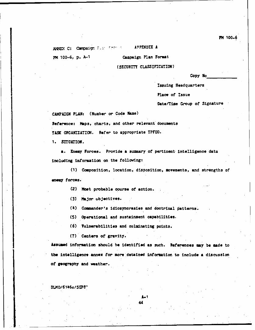
PM 100-6
ANNZD C: Camaign F--APPENDIX A
P'M 100-6, p. A-1 Campaign Plan Format
(SECURITY CLASSIFICATION)
Copy so
Issuing Headquarters
Place of Issue
D-ate/Time Group of Signature
CAMPAIGN PLAN: (Number or Code Name)
Reference: Maps, charts, and other relevant documents
TAS ORGANIZATION. Refer to appropriate TPFDD.
I. SITUATION.
a. Enemy Foces. Provide a 3umary of pertinent, intelligence data
including information on the following:
(1) Composition, location, disposition, movements, and strengths of
eneo forces.
(2) Most probable course of action.
(3). Major objectives.
(4) Conander's idiosyncrasies and doctrinal patterns.
(5) Operational and sustainment capabilities.
(6) Vulnerabilities and culminating points.
(7) Centers of gravity.
Assumed Information should be identified as such. References 0y be made to
the Intelligence annex for more detained information to Include a discussion
of geography and weather.
DLMO/6 1 6c/SPe"
A-1
Iii

A.
45
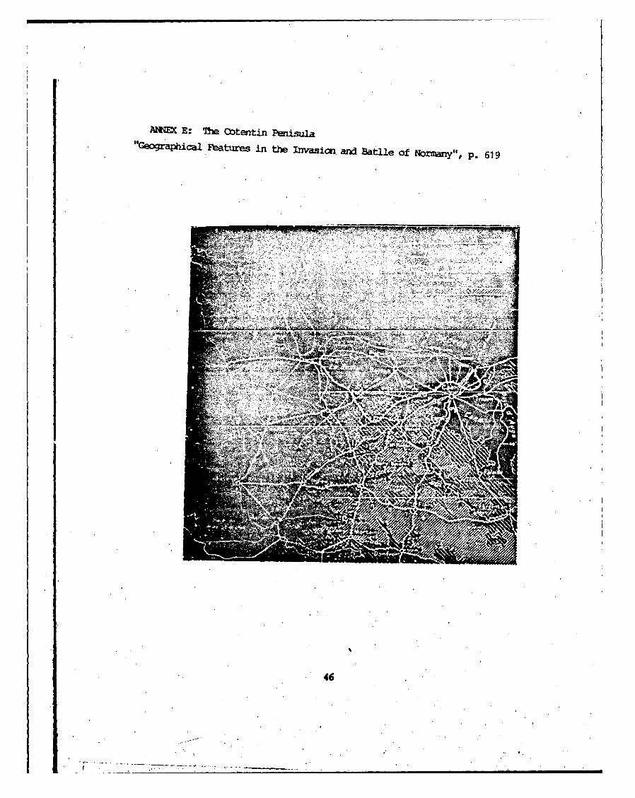
ANNEX E: The Cotentin Penisula"t 1ejo j ca.Fatures in the Thvasicn and Batlle of Normany", P. 619
46

1. This discussion of the meaning of coup d'oeil is taken from Frederickthe Great's Instructions. (pp.338-342). Frerick is very clear that coupd'oeil is a practiced skill about the relationaship between terrain, troops,and the enemy.
2. Edmund R. Thompson, "'he Nature of Military Ceogrape: A PriliminaryStudy." Syracuse University Master's Thesis, 1963. p. 13
3. Louis Peltier and G. Etzel Pearcy, Military Gy. (Princeton, N.J.,D. Van Nostrand COnpany Inc., 1963), p.1
4. John R. Brinkerhoff, 'The Nature of Modern Military Geography." Columbia
University Master's Thesis, 1963. pp. 1112.
5. Tsompson, '"he Nature of Military Geography", p. 21.
6. In addition to Brinkerhoff and Thompson cited above, see J. B. Green,"Military Geography: Tactical Terrain Analysis." Florida State UniversityMaster's Thesis, 1979.
7. Thcxquon, he Nature of Military Geography", p. 217.
8. James A. Marks, "In Search of the Center of Gravity: OperationalInte!ligece of the Battlefield." School of Advanced Military Studiesmnxxgraph, 7 June 1990, p. 41. Marks adapted the model from EM 34-130,(Intelligence Preparation of the Battlefield). The cuter rings were addedto Mark's model by the author to clarify the relationship between geographyand intelligence in the process.
9. The complaint with an unsatisfactory construct for operational IPB wasa evidc throughout the 1990-91 academic year in operaticnial exercisesconducted at the School of Advanced Military Studies. During a SouthwestAsia eercise notionally conduted in Oman, in a post-C=E NAM exercise,and in a exercise conducted in the fictious comtry of Mesopotamia, studentsassigned to the intelligeic staff had difficulty applying the 1:50,000terrain anlysis techniques of tactical IPB to the thousands of miles ofterrain rxwildered at the oprational level of war.
NmmI c1rE a" CEW CEIL
1. T. Miller Maguire, The Outlines of Milita Georaphy. (Crdge, U.K.,Cmbridge University Press), p. 9.
2. Lloyd twiss, Sheran: fighting •%. (New York, Hrcourt Brace andCn,,rrny, 1932), p. 72.
3. efereces to Swt nn's nowre of military eography were found in Maguire
47

(1899), Liddel Hart (1935), and Tnpsai (1963)
4. Frederick, The Instructions of Frederick the Great to his General. 1747.trans. Brig Gen. Thomas R. Phillips. Roots of Strategy vol 1. (Harrisburg,PA., Stackpole Books, 1985), p. 338.
5. David G. Chandler, ne' Capigns of Napoleon. (New York, MacMillan, 1966),p. 145.
6. FM 100-5 (Operations) (Washington, D.C., 00, 1986), p. 76.
7. Brinkerhoff, "The Nature of Modern Military Geography", p. 1.
8. Frederick, Instructicms, p. 341.
9. Ibid. pp. 341-342.
10. Antoine Henri Jomini, Janini and His Smary of the Art of War. ed.Brig. Gen. J. D. Hittle. Roots of Strategy. vol 2. (Harrisburg, PA, StackpoleBooks, 1985), p. 507.
11. Ibid. p. 555
12. Ibid. p. 554
13. Carl vcn Clausewitz, On War. trans. and ed. by *"cheaal Haward and PeterParet. (Princton, Princeton University Press, 1984), p. 102.
14. Ibid.
15. Ibid.
16. Ibid.
17. Ibid.
18. Ibid. p. 103.
19. Ibid. p. 109.
20. Ibid. p. 578.
21. Ibid.
22. See William S. aindf, Mtn er Warfare Handbook, (Boulder,Westview Press, 1985) amid B. H. Liddel Hart,, Strategy (New York, SignmtCassics, 1974).
I.23.0 Sm 7Tm, fr Art of w.. trans. Swimual B. Griffith'. (Oxford, OxfordUniversity Press, 1971), p. 43-44.
24. Ibid. p. 88
25. MAd. p. 138.
48

THE EXERCISE OF COMP D'OEIL
1 . Bruce Catton, This Hollowed Ground. (New York, Washington Square Press,1961)
2. Sane confusion exists in the use of the terms "operational art" and the"operational level of war". This is due in part to the way the terms wareused in FM 100-5 (Operations). The 1982 edition used "operational level ofwar". Th 1986 edition used "oprational art". Ronald D'Amura, "Campaigns:Tnhe Essence of Operational Warfare.", Military Review vol XVII no. 2 (Summer1987) suggests "...they are interchangeable terms used to describe warfarethat achieves strategic aims." (p. 44. For clarity, the following distictionwill be made and apply to the use of the terms in this monograph: "One mustdifferentiate between operational art and the operational level of war. Theformer is an activity while the latter is a perspective of warfighting inwhich tactical events are linked to strategic Heseq.ence. 1ence, theoperational level holds the middle ground between strategy and tactics andis usually the provice of large units". Bob Epstien, '"'ASMP Course 4 Syllabus:The Historical Practice of Operational Art, Academic Year 1990/1991." p.4-I.
3. Edward Hagerman, The American Civil War and the Origins of Modern Warfare:Ideas, Orainzationn and Field Ccmnand. (Blowrdngton, IN, Indiana University
Press, 1988), p. 293.
4. Ibid.
5. G. Murphy Dovan, "Sustaining the Military Arts.", Parameters, vol.XIX no. 3 (September, 1989), p. 22.
$. L. D. Hilder, "A New Day for Operational Art.", Am, (March, 1985),p. 22.
7. Ibid.
8. FM 34,130 (Intelligence Preparation of the Battlefield) (Washington,D.C., GPO, 1989), p. 1-1.
9. 'No recent examples are, Douglas A. Canpell, 'The Real IPB Doctrine.",Military Review, vol LXX no. 10 (October, 1990), pp. 84-87, and DouglasCaibelI and oert McKirmy, '"redictive Intellig -rce: An Old LessonUnlearned.", Military Review. vol LXX, no. 8, (August 1990), pp. 50-59.
10. Patrick O'Sullivan and Jesse Miller, Jr., The Geogphy of Warfare. (NewYork, St. Martin's Press, 1983), p. 24.
11. J.F.C. Fuller, "The Future of Military Engineering.", ya nerJournal. vol 42 (1928), pp. 29-27.
12. Qiarles Erdb'nn, "Applicaticx of Geoiogy to the Principles of War.",Bulletin of the Geological Socety of America vol, 54, (August, 1943), p.
49

1182. Sonne's orginal. work is, "Geologishe und Militargeologishe Karten",Preuss. Geol, Landesanstalt, Jahrb. 1935, Bd. 56, Heft 1, pp. 192-195. Iwas unable to secure an English translation of this seminal work. Anyoneinterested in pursuing the history of the development of the IPB processwould require this source.
13. Formal doctrine is fuzzy concerning which staff officer or staff sectionproduces which product in the IBP process.Tme ambiguity centers on the issueof who is to produce the Decision Support Template and the Event Tenplate.The sequence decribed in this monograph reflects the current methodologytaught by the Tactics Division of the US Army Comuand and General StaffCollege, academic year 1990-91. It is clear at COsc tha the entire staffparticipates in the wargaming process. It is from this process that thecommander selects his friendly course of action. The 34 series Field Manuals(Inteligence) reflect that the DST and ET should be produced by theintelligence officer prior to the commander selecting his course of action.Practical experience suggests that the only reasonable basis for thedevelopment of the final DST and Er would be the ccmmander's decision ona couse of action.
14. Harold Nelson, "Space and Time in on War". Clausewitz and Modern Strate.ed. Micheal Handel. (Londn, Frank Cass and Co., 1986), p. 134. Mr. Nelsonobserves... "While considerations of space and time in On War aresophisticated and filled with implications for modern soldiers, Clausewitzdid not see these factors as the central elements of his theory of war...he asserted that the truely decisive factor was the personality of a commanderin his interaction with the enemy- that cczuander's ability to appraise theoppoent accurately, to energize his own force for rapid movement and boldattack, and to risk that force in the uncertainty of decisive battle." Thoughcoup d'oeil cetainly ment more than "an eye for the ground" to Clausewitz,the prominence of a geographic component is inescapable.
iS. Clausewitz, Cn • p. 109. emphasis in orginal text.
16. Jamini, Art, p. 494.
17. Ibid. p. 461.
18. Sun Tzu, Art of, W2, p. 99
19. Ibid. p. 128. This quote is followed shotly by the famous quote, "'iowthe enemy, know yourself: your victory will never be endangerd. Krnw theground, know the Weather; your victory will then be total." Though this amuch more frequently cited observation about the role of intelligence, itmisses the noe relvent point cosidered in this monograph. How do you knowthese things?
20. Clauseiitz, On War, p. 109.
CLASSICALM WXP OEIL VS. OPERATIC*4AL COUP 'QEIL
1. 'O'Sullivan and Miller, eo of Warfare, p.
s50

2. James Schneider, 'The Theory of Operational Art.", Theoretical ENo. 3. (Draft Editorial Use Cnly), School of Advanced Military Studies, March1988.
3. Chandler, Napoleon, p. 161.
4. Clausewitz, OnC War, p. 177.
5. Micheal Hkward, Clausewitz. (Oxford, OCford University Press, 1983),p. 44.
,6. Jamini, Art of War, p. 460.
7. Sun Tzu, Art of War, p. 35.
8. Schneider, '*Teoretical Paper", p. 9.
9. Howard, Clausewitz, p. 45.
10. Schneider, 'theoretical Paper", p. 15.
11. US Marine Cors Manual FM -1 (C1 gning. (Washington, D.C., GFO,1990), p. 6.
12. David Jablonsky, "Strategy and the Operational Level of War." TheOperational Art of Warfare Across the Spectrum of Conflict. (Carlisle, PA,US Army War College Press, 1987), p. 5.
13. FM 100-6 (Large Unit Operations) Coordinating Draft. (US Army Caomandand General Staff College, 1987), p. vii.
14. Notes from a lecture given by Oberst-LT. (LTC) Zehrer, Fuhrungsakaemie,to the School of Advanced Military Studies, 27 Feb 1991. Used with permission.Notes in author's possession.
15. Ibid.
16. Definitions of Center of Gravity and Decisive points are extrapolatedfrom Schneider, 'theoretical Paper", pp. 26-29.
mmvE WRRE2T STATE Or US OPERATIONAL COUP D'OEIL
1. Napolean Bonapart, Military Maxims of Napolean. ed. Brig Gen T. R..Phillips, Roots of Strategy vol 1, (Harrisburg, PA, Stackpole Books, 1985),p. 410.
2. James Schneider, 'Theoretical Imnplications of the Operational Art.",ltary R vol L•X (September 1990), p. 25.
3. James Delany, "Military Geography-Canvas of the Operational Planner?",School of Advanced Military Studies mnotgraph, Second Term 88-89. p. 30.
S51

4. Schneider, 'Theoretical Paper No. 3", p. 25.
5. TEADOC Pan 11-9 (Blueprint of the Battlefield) (Fort Monroe, VA, USTraining and Doctrine Command, 1990), p. 25.
6. Ibid. text for establishing objectives, p. 6. diagram of continuum, p.37.
7. United States Military Strategy: The Role of American armed Forces ina nging World Order. (Draft Working Paper, 6 March 1991), p. 1.
8. Ibid. p. 31.
9. Ibid. p. 33.
10. 3bid. pp. 34-35.
11. Ibid. p. 49-46.
12. Dr.Larry Yates, Combat Studies Institute, US Command and General StaffCollege, Ft. taavmwerth, KS. Seminar Lecture, 3 April 1991, School ofAdvanced Military Studies. Dr. Yates has A-blished a 'eavenworth Papers"study of the Dominican Republic intervention, 1964 and was an observer atS OMa uarters during '"peraticn Just Cause" while conducting researchof US military efforts in Panama, 1989. Dr. Yates presented the cclusionsof study of US interventions since 1945. Included was the cited observation.The command link, once the intervention begins has universally become onebetween the N and the JTF or specified command commander.
13. The diversion of the Marine KtE from a Mediterranean Deployment toGrenada, 1983, is a case in point.
14. The Joint Staff Officer's Glide 1991. (Armed Forces Staff College PubI) (Washington, D.C., GPO, 1991), p. 6-5.
15. William Mmdel, "Theater Strategy and the Theater C03paing Plan: Both
are Essential", Parameters, vol XVIII, no. 4, (December, 1988), p. 43.
16. Joint Staff Officer's Guide. p. 6-19.
17. Ibid. p. 6-14.
18. Peltier and Pearcy, Military G p. 20.
19. Michael A. Green and Paul Tiberi, "Contingency Plaiming: Time for aChange", Parameters, (September 1987), p. 40.
SLXXZSTE KS• _______ CF OPEATICNAL COUP D'OEIL
1. Peltier and Psarcy, Milita- G, p. 168
52

2. Robert F. Kirby, Battlefield Evironment Assessment for Commanders: AConcept fro Joint and Component Strategy and Operations, (Carlise Barracks,US Army War College, 1988), p. 5.
3. United States Military Strategy (Draft), p. 28.
4. Mendel, "Theater Strategy", p. 48.
5. Peltier and Pearcy, Military Geography pp. 48-51.
CMATICtqAL COUP D'OEIL IN "OPERATION NEPruJE"
1. Frederick Morgan, Overture to Overlord. (Garden City, N.Y., Doubledayand Qmpany, 1950), p. 87.
2. Ibid. p. 86.
3. Ibid. p. 219.
4. O'Sullivan and Miller, The Gy of Warfare, p., 24.
5. Harriscn Reed, "The Development of the Terrain Model in the War"Geological Review, (Otober, 1946), p. 633.
6. Morgan, Overture to Overlord, p. 193.
7. Ibid. p. 133.
8. Authur Davies, "Geographical Features in the Invasion and Battle ofNormandyu", Geological Review, (October 1946), p. 620.
9. Morgan, Overture to Overlord, p. 141.
10. The Invasicn of Western Europe: Part 1 (6 June to 31 December 1944),(USMilitary Academy, 1946), p. 14.
11. Russell F. Weigley, Eisenhower-'s Lieutenants: 7he Campaign of Franceand Germany 1944-1945 (Blocmingtcn,' Indiana Unlversity Press, 1981), p.40.
12. Omaha Beachhead (6 June-13 June 1944), American Forces in Action Series.
(Nashville, MTm Battery Press, 1984), p. 5.
13. Ibid., p. 163.
14. Davies, "Geographical Features", p. 621.
15. Weigley, Eisenh'wer's Leuitant_ p. 40.
16. Runsel F. Weigley, "raum the Nrmandy Beaches to the FalaiseArgentianPodcet: A Critique of Allied Operational Planning in 1944", Military Review(September 1990), p. 49.
53

17. Ibid.
18. !brgan, Overture to Overlord, p. 158.
19. Michael D. Doubler, Busting the Bocace: American Combined Arms Operationsin France 6 June-31 July 1944. (Combat Studies Institute, Ft. leaven.th,1988), p. 21.
20. Weigley, "Friom the Normandy Beaches", p. 64.
54

BIBRTLOAPHY
Books
Catton, Bruce. This Hallowed Grond. New York: Washingtcn Square Press, 1961.
Chandler, David G. The Cpaigns of Napolecn. New York: MacMillan and Sons,S1966.
Clausewitz, Carl vo. On War. trans. and ed. by Micheal Howard and PeterParet. Princeton: Princeton University Press, 1984.
Doubler, Michael D. Busting the Boage: American Combined Arms Operationsin France 6 June-31 July 1944. Ft.Leavenworth: Clombat Studies Institute,1988.
Frederick. The Instructions of Frederick the Great to His Generals, 1747.trans. Brig. Gen. Thcmas R. Phillips. Roots of Strategy. Book 2.Harrisburg: Stackpole Books, 1985.
Hagernan, Bdward. The American Civil War and the Orgn of Modern Warfare.-Ideas, Organization, and Field Candand. BTx n a ndianapolis:Indianan LkUiversity Press, 1988.
Howard, Michael. Clausewitz. Oxford: Oxford University Press, 1983.
Jomini, Antoine Nenri. The Art of War. ed. J.D. Hittle. Roots of Strategy,Book 2, Harrisburg: Stackpole Books, 1987.
Lewis, Lloyd. Serman: Fighting Prophet. New York: Harcourt Brace and Co.,1932.
Liddel Hart, B.H. Strategy. Winnipeg: Sigent, 1974.
Lind, William. Maneuver Warfare Handbook. Boulder: Westview Press,. 1985.
MKDcThl, A.C. The Outlines of Militar ycgrapý. Uxirm: MHfg ~eas, Ltd.1911.
Maguire, T. Miller. The Outlines of Militay 2,. Owbr*ride: CutbridgeUniversity Press, 1899.
ozr~gn, Frederick, Overture to Overlord. Garden City: Doubleday and Company,1950.
O'Sullivan, Patrick and Miller, Jesse Jr. 7he Georp of Warfare. New York:St. Martin's Press, 1983.
Peltier, Liouis C. and Pearcy, G. Eckzel. Military Gmoraphy. Princeton: D.Van Nostrand Qmiany, Inc. 1966.
Sm Tzu. 7he Art of War. tzanm. Samal B. Griffith. Oxford: Oxford UniversityPrems, 1971.
55

Weigley, Russel F. Eisenhwr's Lieutenants: The gam of France ardGermany 1944-1945. Blomington: Indiana University Press, 1981.
Yates, Lawrence A. Power Pack: U.S. Intervention in the Dminican Republic,1965-1966. Leavenworth Papers No. 15. Washington, D.C.: GPO, 1988.
Periodicals and Thesis
Brinkerhoff, John R. "'The Nature of tdern Military Geography". ColumbiaUniversity Master's Thesis, 1963.
Cmpbell, Douqlas A. "'%A* Ial IPB Doctrine", Military Review October 1990pp. 84-87.
Campbell, Douglas A. and McKirny, Robezt. 'Predlctive Intelligence: An OldLesson Unlearned", Military Review August 1990, pp. 50-59.
Davies, Arthur. 'tograhical Factors in the L.asion and Battle of Normandy",Geoloical Review vol XXXVI Octoer 1946, pp. 613-631.
D'hmura, Ronald M. 'Campaigns: The Essence of Operational Warfare", ParametersSummer 1987, pp. 42-51.
DeLony, James W. "Military Geography-Ccvas of the Operational Planner?",School of Advanced Military Studies, Second Term Monograph 88-89.
Donovan, G. Murpy. "Sustaining the Military Arts", Parameters, September1989, pp. 13-23.
Ederman, Charles. ,Application ,of Geology to the Principles of War", Bulletinof the Geological Societ f America August 1946, pp. 1169-1193.
Fuller, J.F.C. "The t of Military Eni•neering", R Journal,v1, 42, 1928, pp. 1927.
Grewf, J.B. "Military Gegraphy: Tactical Terrain Analysis", Florida StateUniversity Master's Tesis, 1979.
Gren,, Michel A. and Tleri, Paul. 'tontngency Planming: Time for a Change",Parzameters. September 1987, pp. 35-45.
Holder, L.D. "A Nw Day Operat Art", At Mardh 1985, pp. 22-32.
........... ' cating T in for nTeter Warfare", Military Review,Sep s 1990, pp. 85-99.
Jalanakyr, David. a nd the Operational level of War", The oaerationalArt of Warfare oss Sg of Conflict. Carlisle: W Army WarColleg Prese, 1987. ,
•arkso, James A. "In Sej of a ater of Gravity: Operatiomal Intelligencea the Battlefield", S'exl of Advancel Military Studies, Second Term
56

Mrxxojraph, 89-90.
MAndel, William A. "Theater Strategy and the Theater Camoaign Plan: Bothare Essential", Parameters, December 1988, pp. 42-48.
Nelson, Harold. "Space and Time in On War", Clausewitz and Modern Strategy.ed. Michael I. Handel. London: Frank Cass and Company Limited, 1986, pp.134-1 49.
Red, Harrison. "'The Development of the Tlerrain Model in the War", GeologicalReview vol. XXXVI October 1946, pp. 632-640.
Schneider, Jais A. 'The Theory of Operatioinal Art", Theoretical Paper No.3. (Draft Editorial Use Only), School of Advanced Military Studies, March1988.
................... "Theoretical Implications of Operatimnal Art", MilitaryReview, St r 1990, pp. 17-27.
1hxipson, dmmund R. "The Nature of Military Geograhy: A Preliminary Survey",Syracuse University Master's Thesis, 1963.
Weigley, Russel F. '"Trm the Normandy Beaches to the Falaise-Argentan Pocket:A Critique of Allied Operational Planning in 1944", Military Review,September 1990, pp. 45-64.
Government Publications and Field Manuals
Field Manual (FM) 34-130 (Intellig Prepaticn of the Battlefield)Washington, D.C.: GFO, 1989.
FPild Manual (FO) 100-5 (Operations) Washt'gtcn, D.C.: GP, 1986.
Feild Manual (FM) 100-6 (La Unit Operations) (Coordinatg t)Ft. Lawvmwdeth: US Army Uomand ad General Staff CWllega, ember1987.
Fleet Marine Field Manual (MM) 1 (Warfightisn) W, D.C.: GPO, 19g9.
Fleet Marine Field Manual (FMM) 1-1 (Campaigning) Washington, D.C.: GPO,1990.
The Joint Officer's Guide 1991. (Armed Fraoas Staff ollege Pub 1) thington,D.C.: GPO, 1991.
Joint Chiefs of Staff Pub 5-02.1 (Joint Operation Planning Volume1 Deliberate Planning Proced,--s) Washigton D.C.: GPO, 1988.
US Amy Traininq and Doctrine Clommand (TRAlOC) Par 11-9 (Blueplint for theBattlefield) ftrt nroe, April 1990.
Uhited States Military Strategy: 7 Role of American Armed Fori in a
S5.7
i

Owin World Order. (Draft Wrking Paper, 6 March 1991).
I5

FI1
"DTE: