a comprehensive public open space categorization …
TRANSCRIPT

29 UNIVERSITI PUTRA MALAYSIA
Alam Cipta Vol 8 (Special Issue 1) December 2015
A COMPREHENSIVE PUBLIC OPEN SPACE CATEGORIZATION USING CLASSIFICATION SYSTEM FOR SUSTAINABLE DEVELOPMENT OF PUBLIC OPEN SPACES
Ashkan Nochian1*, Osman Mohd Tahir1, Suhardi Maulan1 & Mehdi Rakhshandehroo1
Department of Landscape Architecture, Universiti Putra Malaysia, Serdang, Malaysia1*
*Corresponding author: [email protected]
ABSTRACT
Our quality of life significantly depends on open spaces. They offer facility
provision for a wide range of social interactions and provide habitats for flora
and fauna. A classification of spaces would be useful in preparing public open
space policies and fulfilling structure plan. This study aims to propose a
comprehensive open space categorization using classification system for
Malaysia. A deep investigation in sources in Malaysia reveals that there is lack
of comprehensive classification of open spaces and just a hierarchy of open
spaces presented. A critical literature review were carried out for this study to
understand the approaches of this comprehensive classification and adapted
them according to Malaysia context. In order to come up with a comprehensive
classification in Malaysia, an analysis of comparison between several cities in
different countries was done. The outcomes of the study will provide a
systematic classification use for planner and policy makers in preparing open
space strategies and in setting development plan policies. It is also useful for
designers to obtain the best possible conceptual ideas when designing open
spaces.
Keywords: Public open space; Open space classification; Sustainable
development
1. INTRODUCTION
Public open space (POS) is planned and managed for current and future
generations for the purpose of public protection and pleasure of unique values
[1]. It has constantly played an important role in improving the quality of life
for the urban populations and in supporting urban inhabitants. [2]. POS is a built
environment factor that is essential for wellbeing and health through the life
time, and contributes to the liveability of an area [3]. They let people to interact
with the natural environment and provide habitats for flora and fauna. They are
also essential in identifying the identity and character of habitations. Linking
them in a green network will provide greater benefits for public, the
environment as well as biodiversity [4].
In short, benefits of POS can be describe in term of social, economy and
environmental aspects. Well-managed and maintained spaces would create
opportunities for all segments of the communal to interact [5]. Additionally,
well-designed and planned spaces help to enhance the quality of retail, business
and leisure developments, making them more attractive to potential investors,
users and customers [6]. Open space can define the landscape and townscape
structure and identity of settlements. Well-designed networks of spaces help to
encourage people to travel safely by foot or bicycle [7].
To reach the maximum level of efficiency of POS, the planners and the
designers need to know what kind of open space they exactly deal with. In other
words, by knowing some important characteristics of spaces such as most
privilege users, most suitable functions and landscape/environmental
characters, the designers and planners may create POS more effectively.
Therefore a comprehensive classification is a useful tools to assist professional,
managers and all policy makers who are engaged in this regard to achieve
sustainable development.
This study will focus on open space categorization based on
classification method. Herein, before explaining the classification system, it is
important to determine the meaning of POS and what method could be applied
for achieving the result

30 UNIVERSITI PUTRA MALAYSIA
Alam Cipta Vol 8 (Special Issue 1) December 2015
2. DEFINITION OF TERMS
2.1 Public Open Space
Open space is a broad term that can be used to describe all land that does not contain buildings and structures. It can include public and private land. However when we discuss about open space in design and planning we basically use the term ‘open space’ as ‘urban open space’. Additionally, this study seek to classify public open space rather than private land. So in the following content, it started to define open space in a broad term and gradually specified it to the purpose of this study.
It seems that the term open space was used in 1833 firstly by a committee in a public trail in London [8]. There is also believed this committee was the agency responsible for introducing the term open spaces [9].
One broad definition could be argued that any area within the urban envelope not occupied by buildings constitutes open space. Hence this lead to comparing different definition by other countries. For example the London Plan defined open space as: “All land use in London that is predominantly undeveloped other than by buildings or structures that are ancillary to the open space use. The definition covers the broad range of open space types within London, whether in public or private ownership and whether public access is unrestricted, partially restricted or restricted” [10]. In city of Melbourne, Australia, open space is defined as: “publicly owned land that is set aside primarily for recreation, nature conservation, passive outdoor enjoyment and public gatherings. This includes public parks, gardens, and reserves, waterways, publicly owned forecourts and squares” [11].
As demonstrated above there are varying definitions of open space in use across all levels of government and the planning and recreation sectors. Some definitions focus on how the open space is used, while others focus on the land type.
For the purpose of this study the following definitions of public open space adapted from the Malaysia, Town and Country Planning Act 1976 will be used. It defined open spaces as: “any land whether enclosed or not which is laid out or reserved for laying out wholly or partly as a public garden, park, sports and recreation ground, pleasure ground, walk or as a public place [12]. Furthermore for a better understanding of the term ‘public’, it can be defined as publicly accessible green and open spaces and which exclude private open spaces such as backyards, gardens and balconies and so on [13].
As a result to finalized the term POS for the purpose of this study, it would be any open spaces that define in Malaysian law with the accessibility by public (people). Land that is set aside in the precinct structure plan for public recreation or public resort; or as parklands; or
for similar purposes. Incorporates active and passive open space.
2.2 Comprehensive Categorization of Open Space
Based on Classification Method
There are generally two methods used in open space categorization ie ‘Typology’ and ‘Classification’. Typology refers to the type of open spaces regardless of inner characters of them. In fact by using typology method, we mainly focus on type of spaces such as ‘Squares’ ‘Plazas’, ‘Atrium/Indoor/ Marketplaces’, ‘Streets’, ‘Residential’, ‘Parks’, ‘Markets’, and so on [14] [15]. Classification is used when the characters of spaces are included in the categorization. In addition open space has different characteristics and this influences the way in which open space is used and valued.
Open space character is influenced by a range of factors such as
its location, level of development, primary function, and interface with
adjoining land use and urban form [16][17]. The scope and focus of this
study will be on open space categorization based on classification
method.
The classification method in classifying open spaces generally covers three approaches included i) the catchment hierarchy (who will use the open space), ii) function (the role of the open space) and iii) landscape/environmental character (what the open space looks like) [18]. Each approach are described below.
2.2.1 Catchment Hierarchy
This term in some sources is simply so-called hierarchy. Hierarchy is basically determined by the: Geographical area being serviced (catchment)
Size
Level of use
Significance Typical size and how far a user might travel to visit the site.
Catchment hierarchy reflect the distance people would be prepared to travel to use open spaces or the sphere of influence and origins of users [1][19]
2.2.2 Function
Each open space is assigned with a functional classification to reflect its primary use. It is used to define the purpose planned for a space. A functional classification, considering the primary purpose or use of the open space within the network [20]. Primary use and expected

31 UNIVERSITI PUTRA MALAYSIA
Alam Cipta Vol 8 (Special Issue 1) December 2015
activities identifies three primary types of open spaces [21]: Recreation spaces Sport spaces Nature space
2.2.3 Landscape / Environmental Setting
Each open space is assigned with a landscape/environmental classification that reflects its primary physical setting [22]. A landscape setting type classification is proposed to assist with the differentiation of sites on the basis of experiences they offer and for planning, management and marketing purposes.
These would be used where the setting type may not be evident from the functional classification [23]. Landscape character is used to define the desirable landscape and/or vegetation type of a space.
To conclude this section it is important to know that the key to getting the most out of the classification system is to apply it in conjunction with the ‘Site Analysis’ and Context Assessment’ and ‘Precinct Objective’ [1]. The idea being that the site analysis and context assessment and precinct objectives will have identified those characteristics of a site and its surrounds that should be reinforced and those that may pose constraints [24]. The following flow chart shows generally when and how it should be used (see figure 1).
These would be used where the setting type may not be evident
from the functional classification [23]. Landscape character is used to define the desirable landscape and/or vegetation type of a space.
reinforced and those that may pose constraints [24]. The following flow chart shows generally when and how it should be used (see figure 1).
Figure 1: Application of comprehensive classification for space development

32 UNIVERSITI PUTRA MALAYSIA
Alam Cipta Vol 8 (Special Issue 1) December 2015
3. METHODOLOGY
The study will engage with a qualitative approach, analyzing literature and comparing different POS classification method that has been applied in several develop and developing countries. The study considers Malaysia’s POS classification in three level which include the national, state and city level. It will also observe the shortcomings that exist in Malaysian POS classification as compare to other countries [25].
4. OPEN SPACE CLASSIFICATION IN OTHER
COUNTRIES AND MALAYSIA
4.1 United States 4.1.1 Michigan
POS Classification provides by The Michigan Department
of Natural Resources [26] as presented in table 1.
Table 1: Parks and Open Space, classifications, Grants Management Michigan Department of Natural Resources, 2009
Classification
Mini-Parks
Neighbourhood Park
School-Park
Community Park
Large Urban Park
Natural Resource Areas
Greenways
Sports Complex
Special Use
*Private Park / Recreation Facility
*Parks and recreation facilities that are privately owned yet contribute to the public park and recreation system.
Based on description in section 2.2, it can be conclude that the type of POS classification in Michigan is not clearly defined which factors used to categorized open spaces. Even though the majority of categorizing is based on ‘function’, some of items are presented by its ‘hierarchy’.
4.1.2 City of Coon Rapids
Coon Rapids Parks, Open Space, and Trail System Plan was adopted by the City Council [27]. The POS classification was extracted and presented in table 2. Table 2: Classification of parks and open space, City of Coon Rapids, 2001
Classification
Mini And Neighbourhood Park
Community Park
Youth Athletic Complex
Community Athletic Complex
Community Preserve
Protected Open Space
Special Use Park
Regional Park
School Site
Regarding United Stated POS classification, it can be concluded
that there are not clear categorization as describe in section 2.2. In other words in aforementioned table of United States both catchment hierarchy and function are mixed to create POS classification; however the influence of ‘functional classification’ is more obvious.
4.2 Singapore
The Urban Redevelopment Authority in Singapore have a classification system for POS [28]. To follow what POS exactly classified in Singapore, the same terms are used in table 3 which are ‘open space’, ‘park’, ‘beach area’, and ‘sport & recreation’.

33 UNIVERSITI PUTRA MALAYSIA
Alam Cipta Vol 8 (Special Issue 1) December 2015
Table 3: Zoning Interpretation, Master plan, Urban Redevelopment Authority, Singapore, 2014
Zoning Example of Developments
Open Space
1. Wooded Area
2. Swamp Area
3. Natural Open Space
4. Public Promenades
5. Outdoor Pedestrian Malls
6. Landscaped Plazas
Park 1. National Park
2. Regional Park
3. Community/Neighbourhood Park
4. Park Connectors
5. Zoological Gardens, Botanic Gardens,
Beach Area Nil
Sports & Recreation
1. Sports Complex/ Indoor Stadium
2. Swimming Complex
3. Golf Course
4. Golf Driving Range
5. Recreation Club
6. Campsite
7. Chalet
8. Marina
9. Water Sports Centre
10. Outward Bound School
11. Theme Park
Similar to United States, Singapore also, has no clear POS
classification according to the factors define in section 2.2. But it can be said that the classification of POS in Singapore is mainly based on ‘function’. The ‘landscape/environmental character’ like ‘Wooded Area’ and Swamp Area has also applied. By the means of catchment hierarchy parks have also been classified.
4.3 UK (London) This study for analyzed An Open Spaces Strategy for the London Borough of Tower Hamlets 2006 – 2016 [10] as shown in table 4.
Table 4: London Plan Open Space, London Borough of Tower Hamlets, 2011
Open Space Category
Regional
Metropolitan
District / Major Parks
Local Parks
Small Local Parks
Pocket Parks
Linear Open Spaces
The table 4 demonstrate that the POS classification is only
based on ‘catchment hierarchy’ except for ‘Linear Open Space’ which could be an item of ‘function’ classification.
4.4 Australia
It is observed that Australia has a broad studies and preparations for POS classification as presented in the following tables below.
4.4.1 City of Marion
The OPS classification was derived from the City of Marion’s Draft Open Space and Recreation Strategy 2006-2016 [22] as summarized in table 5, 6, and 7.
Table 5: User Catchment levels and classifications, Open Space & Recreation Strategy 2006 – 2016, City of Marion, 2006
User Catchment Level
Local Level Distributed
Neighbourhood Level
Precinct Level
Regional Level
State Level Land

34 UNIVERSITI PUTRA MALAYSIA
Alam Cipta Vol 8 (Special Issue 1) December 2015
Table 6: Functional classifications, Open Space & Recreation Strategy 2006 – 2016, City of Marion, 2006
Functional Classifications
Recreation - Structured, Physically Active
Recreation -Unstructured, Physically Active
Recreation - Structured, Passive
Recreation - Unstructured, Passive
Physical Activity / Linkage
Cultural / Heritage
Tourism
Visual Amenity / Environmental
Unclassified
Table 7: Landscape/Environmental classifications, Open Space & Recreation Strategy 2006 – 2016, City of Marion, 2006
Landscape/Environmental Classifications
Formal / Landscaped
Turf / Lawn
Watercourse
Natural Area
Undeveloped Area
Wetland
Drainage / Stormwater
Buffer
Hard Surface
Coastal
Unclassified
Unlike the previous classification, the city of Marion, Australia provided a comprehensive open space classification. 4.4.2 Hume City Council
Hume City Council has also provided a comprehensive open space classification system [1] as shown in tables 8, 9, and 10.
Table 8: Hierarchical classifications, Hume City Open Space Classification System, Hume City Council, 2003
Level of Hierarchy
Neighbourhood
Sub-Regional
Regional
Table 9: Functional classifications, Hume City Open Space Classification System, Hume City Council, 2003
Function Name
Access Way / Linkage / Bicycle Or Walking Trail
Community Horticulture / Vegetable Growing / Farming
Conservation of Flora & Fauna
Crematoria / Remembrance Garden / Cemetery
*Cultural / Community Gathering / Event
Drainage / Storm Water Management
Environmental/Visual Amenity
Family/Social Recreation
Historic/Cultural Protection
Indoor Community Activity Centre
Outdoor Sports
Play Space
Relaxation / Contemplation / Urban Escape
Water Based Recreation
*Note: This often may only be a secondary function.
Table 10: Landscape character classification, Hume City Open Space Classification System, Hume City Council, 2003
Landscape Character
Bushland
Creek/River Corridor
Formal Ornamental Garden
Lake
Lawn or Managed Turf
Narrow Grass Or Paved Corridor
Native Grassland
Open Grassy Area
Open Parkland
Outdoor Sports Facilities
Road Side Plantation / Tree Reserve
Rough Unmanicured Area
Vegetable Garden /Pasture / Agriculture
Wetland

35 UNIVERSITI PUTRA MALAYSIA
Alam Cipta Vol 8 (Special Issue 1) December 2015
The Hume City Council provided a comprehensive POS classification method based on all the three parameters mentioned in section 2.2.
4.4.3 City of Maroondah Maroondah City Council adapted “Making the Best of Open
Space – an Open Space Strategy for the City of Maroondah” [29]. As its POS classification system was extracted and is presented as in table 11, 12, and 13.
Table 11: Contextual or catchment classification, An Open Space Strategy for the City of Maroondah, 2005
Level of Hierarchy
Local (or Neighbourhood) Park
Precinct (or District) Park
City Wide (or Municipal)
Regional Open Space
Table 12: Functional classification, An Open Space Strategy for the City of Maroondah, 2005
Function
Play
Social Family / Recreation
Community Horticulture
Cemetery / Memorial / Remembrance
Ornamental / Botanic Garden
Access Way / Trail
Sport
Flora / Fauna Conservation
Drainage / Stormwater Management / Floodway
Visual Amenity
Community Facility Forecourt
No Identified Function
Conservation of Cultural Heritage
Relaxation / Contemplation / Escape
Lookout / Ridgeline Reserve
Water Based Recreation
School / Educational Institute
Table 13: Landscape setting classification, An Open Space Strategy for the City of Maroondah, 2005
Landscape Setting Types
Bushland / Forest
Exotic, Ornamental or Specimen Plantings
Open Grassland
Specialised Sports Surfaces (e.g. Synthetic or Enclosed)
Lawn or Managed Turf
Open Parkland
Creek Corridor
Lake / Waterbody
Rough Natural Area
Paved Area
Crop or Plantation
Tree Plantation
Wetland
House Built on Reserve
POS classification system of the city of Maroondah, Australia is
also a comprehensive classification.
4.4.4 City of Melbourne City of Melbourne Open Space Strategy Technical Report [30]
classified open space as presented in table 14 and 15.
Table 14: Hierarchy of open space, City of Melbourne Open Space Strategy Technical Report, 2012
Hierarchy
Capital City
State
Regional
Municipal
Neighbourhood
Local
Small Local
Small Local Link

36 UNIVERSITI PUTRA MALAYSIA
Alam Cipta Vol 8 (Special Issue 1) December 2015
Table 15: Open space character classification, City of Melbourne Open Space Strategy Technical Report, 2012
Character Classification
Botanical
Civic Space
Events
Formal
Heritage
Informal Use
Linear
Linking Space
Nature Conservation
Play
Railway Easement/Siding
Recreation
Restricted Sporting / Recreation
Seating / Viewing
Service Easement
Significant Road Reservation
Sporting
Square
Undeveloped
Urban Plaza
Water Feature
Waterway
Unlike the previous classification of Australian cities, City of
Melbourne provided open space classification only based on hierarchy and character. In fact in this classification, function and landscape/ environment characters have been merge together.
Regarding Australia POS classification, it can be observed that all three approaches of classification method as describe in section 2.2 clearly used except for the city of Melbourne.
4.5 Malaysia To achieve an applicable comprehensive POS classification for
Malaysia, the study review most common classification in three levels including national level, state level and city level.
4.5.1 National Level: Department of Town and Country Planning, Malaysia In Malaysia the classification of open space for recreational
purposes adopted by the Department of Town and Country Planning
(JPBD) under Ministry of Housing and Local Government [31][19] as mentioned in table 16 (Basri, 2011).
Table 16: Catchment hierarchy classification, Hierarchy of Open Spaces, Town and Country Planning Department Peninsular Malaysia (2002)
Hierarchy Size (ha.) Population Catchment
National Unlimited National
Regional 100 Regional
Urban 40 > 50,000
Local 8 12,000 - 50,000
Neighbourhood 2 3,000 - 12,000
Playing Field 0 - 0.6 1,000 - 3,000
Playground 0 - 0. 2 300 - 1,000
Roof Garden Varies Target Group
The introduced classification in national level is mainly based on ‘catchment hierarchy’. However, Playing Field, Playground, and Roof Garden can be considered as ‘function’.
4.5.2 State Level: State of Selangor In addition to the national classification, some of local authorities
have also introduced POS classification system based on their needs. This study has chosen Selangor state as the most developed state in Malaysia. The state also has the highest population in Malaysia, with a high standard of living. One of the most common POS classification system by local authorities provided by Selangor Town and Country Planning Department [32] presented in table 17.
Table 17: Catchment hierarchy classification, Guidelines on hierarchy of open space, Manual Planning Standard and Guidelines Selangor, 2nd ed., 2010.
Hierarchy Size (ha.) Service Distance
Urban 40-100 Within 5km
Local 8-40 Within 3km
Neighbourhood 2-8 Within 1.5km
Playground 0.6-2 Within 1km
Playing Lot 0.2-0.6 Within 0.5km
It is observed that the main classification system at this state level is ‘catchment hierarchy’ except for playground and playing lot.

37 UNIVERSITI PUTRA MALAYSIA
Alam Cipta Vol 8 (Special Issue 1) December 2015
4.5.3 City Level: Kuala Lumpur Kuala Lumpur is the capital city of Malaysia. The Kuala Lumpur
Structure Plan 2020 [33] has classified of open space in the city as in table 18.
Table 18: Catchment hierarchy classification, Open Spaces, Recreational and Sports Facilities, Kuala Lumpur Structure Plan 2020, (2004)
Hierarchy Minimum Size Population
District park 40 ha. 200,000
Neighbourhood Park 10 ha. 50,000
Local Park 2 ha. 20,000
Local Play Area 0.5 ha. 5,000
Sport Complex 2.5 ha. 50,000
It is observed that the POS classification uses for Kuala Lumpur is based on ‘catchment hierarchy’. The exception here is ‘Sport Complex’ that categorizes as ‘function’.
5. Analysis of Comparison The analysis of each cities in several countries reveals that
Australia comprehensive POS classification could inspired in development of a similar classification system for Malaysia. Therefore the POS classification provided by the cities of Australia could be adopted and adapted to affectively assist in proposing a comprehensive POS classification system for Malaysian context. In addition to Australia, the items used in the cities of the US, Singapore and London open space classification will also apply.
This study presented three level of classification in Malaysia. The investigation in all three levels revealed that the open space classifications are mainly bases on ‘catchment hierarchy’ approach. In other words, there is a lack of comprehensive open space classification in Malaysia. Therefore a comprehensive classification as a framework would be a useful tools for sustainable development and management of public open spaces.
6. Result and Discussion To create a new comprehensive POS classification, the study
cumulate all possible items of each approach in the studied cities/countries. In fact this research will suggest all possible items that have been presented in other cities/countries for creating POS classification in Malaysia.
It should be noted that few items are common in hierarchy,
functional and landscape/environmental tables that have been studied. This is because each city or country has its own criterion to classify open spaces. In this case, the study categorize the items in suitable approach (column) based on Malaysian context. Finally, the items will be chosen and renamed based on the conditions of Malaysia to be more applicable and understandable.
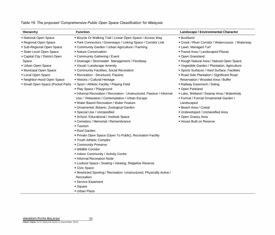
In table 19 a cumulative list of items in all three approaches included ‘catchment hierarchy’, ‘function’, and ‘landscape/environmental character’ proposed as a new ‘comprehensive POS classification’ for Malaysia.
In fact table 19 presents all possible items based on the comparison made by this research to be applied in Malaysia for the benefits of designing, planning and management of public open spaces in Malaysia.
7. Conclusion As society is becoming gradually urbanized, environmental
quality is degrading. Hence the development of open space in our rapid growing cities is one of ultimate solution to maintain or increase the quality of life [8]. This study reviewed and compared some of the most commonly used open space classification system in other develop and developing countries. The suggested comprehensive POS classification for Malaysia is developed through rigorous analysis and comparison of existing POS classification among the cities and countries.
The importance of comprehensive classification for open spaces is to determine the level of development for each open space. The classification also help the local authorities and managers to define basic service standards and required facilities by function and landscape/environmental character in conjunction with catchment hierarchy. This two benefits of comprehensive classification would be an important topic to study in future by other scholars.
Finally, the study suggested a broad items in each approach for creating a comprehensive POS classification in Malaysia. Therefore, the whole process and finding of the study is a useful tools for other researchers and professional bodies in urban and landscape field.
38 UNIVERSITI PUTRA MALAYSIA
Alam Cipta Vol 8 (Special Issue 1) December 2015
Table 19: The proposed ‘Comprehensive Public Open Space Classification’ for Malaysia
Hierarchy Function Landscape / Environmental Character
National Open Space
Regional Open Space
Sub-Regional Open Space
State Level Open Space
Capital City / District Open
Space
Urban Open Space
Municipal Open Space
Local Open Space
Neighbor-Hood Open Space
Small Open Space (Pocket Park)
Bicycle Or Walking Trail / Linear Open Space / Access Way
Park Connectors / Greenways / Linking Space / Corridor Link
Community Garden / Urban Agriculture / Farming
Nature Conservation
Community Gathering / Event
Drainage / Stormwater Management / Floodway
Visual / Landscape Amenity
Community Facilities, Social Recreation
Recreation - Structured, Passive
Historic / Cultural Heritage
Sport / Athletic Facility / Playing Field
Play Space / Playground
Informal Recreation / Recreation - Unstructured, Passive / Informal
Use / Relaxation / Contemplation / Urban Escape
Water Based Recreation / Water Feature
Ornamental, Botanic, Zoological Garden
Special Use / Unclassified
School, Educational / Institute Space
Cemetery / Memorial / Remembrance
Tourism
Roof Garden
Private Open Space (Open To Public), Recreation Facility
Youth Athletic Complex
Community Preserve
Wildlife Corridor
Indoor Community / Activity Centre
Informal Recreation Node
Lookout Space / Seating / Viewing, Ridgeline Reserve
Civic Space
Restricted Sporting / Recreation -Unstructured, Physically Active /
Recreation
Service Easement
Square
Urban Plaza
Bushland
Creek / River Corridor / Watercourse / Waterway
Lawn, Managed Turf
Paved Area / Landscaped Plazas
Open Grassland
Rough Natural Area / Natural Open Space
Vegetable Garden / Plantation, Agriculture
Sports Surfaces / Hard Surface, Facilities
Road Side Plantation / Significant Road
Reservation / Wooded Area / Buffer
Railway Easement / Siding
Open Parkland
Lake, Wetland / Swamp Area / Waterbody
Formal / Formal Ornamental Garden /
Landscaped
Beach Area / Costal
Undeveloped / Unclassified Area
Open Grassy Area
House Built on Reserve

39 UNIVERSITI PUTRA MALAYSIA
Alam Cipta Vol 8 (Special Issue 1) December 2015
8. Acknowledgements
The authors wish to thank the Research Management Centre (RMC) OF Universiti Putra Malaysia (UPM) for funding this study.
9. References
[1] Hume City Council, “Section 3 Hume City Open Space Classification System,” Hume City Council, 2003. [2] L. Martinelli, A. Battisti, and A. Matzarakis, “Multicriteria analysis model for urban open space renovation: An application for Rome,” Sustain. Cities Soc., vol. 14, pp. e10–e20, 2014. [3] K. Villanueva, H. Badland, P. Hooper, M. J. Koohsari, S. Mavoa, M. Davern, R. Roberts, S. Goldfeld, and B. Giles-Corti, “Developing indicators of public open space to promote health and wellbeing in communities,” Appl. Geogr., vol. 57, pp. 112–119, 2015. [4] J. Veitch, J. Salmon, K. Ball, D. Crawford, and A. Timperio, “Do features of public open spaces vary between urban and rural areas?,” Prev. Med. (Baltim)., vol. 56, no. 2, pp. 107–111, 2013. [5] M. Khotdee, W. Singhirunnusorn, and N. Sahachaisaeree, “Effects of Green Open Space on Social Health and Behaviour of Urban Residents: A Case Study of Communities in Bangkok,” Procedia - Soc. Behav. Sci., vol. 36, no. June 2011, pp. 449–455, 2012. [6] J. Wu and A. J. Plantinga, “The influence of public open space on urban spatial structure,” J. Environ. Econ. Manage., vol. 46, no. 2, pp. 288–309, 2003. [7] L. M. Brander and M. J. Koetse, “The value of urban open space: Meta-analyses of contingent valuation and hedonic pricing results,” J. Environ. Manage., vol. 92, no. 10, pp. 2763–2773, 2011. [8] T. Maruani and I. Amit-Cohen, “Open space planning models: A review of approaches and methods,” Landsc. Urban Plan., vol. 81, no. 1–2, pp. 1–13, 2007. [9] P. H. Ibrahim, M. Md Dali, and S. Y. Muhammad Yusoff, “Implementation of Open Space: The Need for Uniform Policy,” J. Sustain. Dev., vol. 6, no. 7, pp. 16–26, 2013. [10] “An Open Spaces Strategy for the London Borough of Tower Hamlets,” London Borough of Tower Hamlets, 2011. [11] City of Melbourne, “Open Space Strategy: Planning for Future Growth,” Melbourne, 2012. [12] T. and C. P. D. P. Malaysia, “Planning Standards Open Spaces and Recreation,” Town and Country Planning Department Peninsular Malaysia, 2006. [13]J. Byrne and N. Sipe, “Green and open space planning for urban consolidation - A review of the literature and best practice,” 2010. [14] S. Bell, A. Montarzino, and P. Travlou, “Mapping research priorities for green and public urban space in the UK,” Urban For. Urban Green.,
vol. 6, no. 2, pp. 103–115, May 2007. [15] M. Carmona and F. M. Wunderlich, Capital spaces: the multiple complex public spaces of a global city. 2013. [16] C. Nicol and R. Blake, “Classification and Use of Open Space in the Context of Increasing Urban Capacity,” Plan. Pract. Res., vol. 15, no. 3, pp. 193–210, 2000. [17] M. Rakhshandehroo and M. J. M. Yusof, “Establishing new urban green space classification for Malaysian cities,” in IFLA Asia Pacific Congress, 2014, no. 06, pp. 1–13. [18] Parks and Leisure, “Open Space Strategies,” Melbourne, 2013. [19] B. H. Basri, “Valuing the Attributes of Malaysian Recreational Parks : A Choice Experiment Approach,” Newcastle University, 2011. [20] E. Koomen, J. Dekkers, and T. van Dijk, “Open-space preservation in the Netherlands: Planning, practice and prospects,” Land use policy, vol. 25, no. 3, pp. 361–377, 2008. [21] Rutherford Julie, C. May, and K. Christidis, “Classification framework for public open space,” Australasian Parks and Leisure, 2013. [22] E. Delgado, “Open Space & Recreation Strategy 2006 – 2016,” City of Marion, 2006. [23] S. S. Y. Lau, Z. Gou, and Y. Liu, “Healthy campus by open space design: Approaches and guidelines,” Front. Archit. Res., vol. 3, no. 4, pp. 452–467, 2014. [24] O. M. Tahir and M. H. Roe, “Sustainable urban landscapes: Making the case for the development of an improved management system,” ALAM CIPTA, Int. J. Sustain. …, vol. 1, no. 1, pp. 17–24, 2006. [25] R. A. P. Louis M. Rea, Designing and conducting survey research: A comprehensive guide. John Wiley & Sons, 2014. [26] N. Resources, “Guidelines for the Development of Community Park, Recreation, Open space, and Green Plans,” Prepared by: Grants Management Michigan Department of Natural Resources, 2009. [27] “Parks and open space,” City of Coon Rapids Comprehensive Plan, 2001. [28] “Master plan written statement 2014,” Urban Redevelopment Authority of Singapore, 2014. [29] “Making the Best of Open Space – an Open Space Strategy for the City of Maroondah Part 2. Context,” City of Maroondah, 2005. [30] F. M. Committee, “City of Melbourne Open Space Strategy Technical Report,” Melbourne, 2012. [31] M. A. Marzukhi and H. A. Karim, “Evaluating Shah Alam City Council (MBSA) Guidelines on the Hierarchy of Neighbourhood Open Space. Case Study, Section 7 Shah Alam,” Res. Manag. Inst., no. July, pp. 1–27, 2011. [32] M. A. Marzukhi, H. A. Karim, and M. F. Latfi, “Evaluating the Shah Alam City Council Policy and Guidelines on the Hierarchy of Neighborhood Open Space,” Procedia - Soc. Behav. Sci., vol. 36, no.

40 UNIVERSITI PUTRA MALAYSIA
Alam Cipta Vol 8 (Special Issue 1) December 2015
June 2011, pp. 456–465, 2012. [33] K. L. C. Hall, “Kuala Lumpur Structure Plan 2020,” 2004.