a description of hydrogeologic units in the portland … · drinking-water supplies from the bull...
TRANSCRIPT

A DESCRIPTION OF HYDROGEOLOGIC UNITS IN THE PORTLAND BASIN, OREGON AND WASHINGTON
U.S. GEOLOGICAL SURVEY Water-Resources Investigations Report 90-4196
Prepared in cooperation withCITY OF PORTLAND BUREAU OF WATER WORKS, INTERGOVERNMENTAL RESOURCE CENTER and OREGON WATER RESOURCES DEPARTMENT


A DESCRIPTION OF HYDROGEOLOGIC UNITS IN THE PORTLAND BASIN, OREGON AND WASHINGTON
By R.D. Swanson, W.D. McFarland, J.B. Gonthier, and J.M. Wilkinson
U.S. GEOLOGICAL SURVEY
Water-Resources Investigations Report 90-4196
Prepared in cooperation with
CITY OF PORTLAND BUREAU OF WATER WORKS,
INTERGOVERNMENTAL RESOURCE CENTER, and
OREGON WATER RESOURCES DEPARTMENT
Portland, Oregon
1993

U.S. DEPARTMENT OF THE INTERIOR BRUCE BABBITT, SecretaryU.S. GEOLOGICAL SURVEY Dallas L. Peck, Director
For additional information Copies of this report canwrite to: be purchased from:
Oregon Office Chief U.S. Geological SurveyU.S. Geological Survey Books and Open-File Reports Section10615 S.E. Cherry Blossom Drive Federal Center, Box 25425Portland, OR 97216 Denver, CO 80225
11

CONTENTSPage
Abstract --------------------------------------------------------- 1Introduction ----------------------------------------------------- 1
Purpose and scope ------------------------------------------- 5Acknowledgments --------------------------------------------- 5Previous investigations ------------------------------------- 5Methods of investigation ------------------------------------ 7
Geologic setting ------------------------------------------------- 9Older rocks ------------------------------------------------- 9Sandy River Mudstone and Troutdale Formation ---------------- 10Cascade Range volcanics and Boring Lava --------------------- 13Late Pliocene to Holocene sediments ------------------------- 14
Geologic structure ----------------------------------------------- 15Hydrogeologic units ---------------------------------------------- 17
Older rocks subsystem --------------------------------------- 19Lower sedimentary subsystem --------------------------------- 21
Sand and gravel aquifer -------------------------------- 21Confining unit 2 --------------------------------------- 23Troutdale sandstone aquifer ---------------------------- 24Confining unit 1 --------------------------------------- 25Undifferentiated fine-grained sediments ---------------- 26
Upper sedimentary subsystem --------------------------------- 26Troutdale gravel aquifer ------------------------------- 27Unconsolidated sedimentary aquifer --------------------- 29
Summary ------------- --------------------------------------------- 30Selected references ---------------------------------------------- 32
iii
ILLUSTRATIONS
Plate 1. Hydrogeologic units in the Portland Basin.2. Hydrogeologic sections in the Portland Basin.3. Altitude of top of older rocks.4. Altitude of top and thickness of sand and gravel aquifer,5. Altitude of top and thickness of confining unit 2.6. Altitude of top and thickness of the Troutdale sandstone
aquifer.7. Altitude of top and thickness of the confining unit 1.8. Altitude of top and thickness of the undifferentiated
fine-grained sediments.9. Altitude of top and thickness of the Troutdale gravel
aquifer. 10. Thickness of the unconsolidated sedimentary aquifer.
Figure 1. Map showing location of the Portland Basin studyarea ------------------------------------------------ 2
2. Map showing regional geology of the Portland Basin ---- 33. Summary of geologic and hydrogeologic units ----------- 124. Comparison of hydrogeologic unit terminology for
the Portland Basin ---------------------------------- 18
TABLES
Table 1. Altitude of the top of hydrogeologic units forselected wells, in feet ---------------------------- 37
IV

CONVERSION FACTORS AND ABBREVIATIONS
Multiply
gallon (gal)
By To obtain
foot (ft) mile (mi)
acre square mile (mi 2 )
Length
0.3048 1.609
Area
4,047. 2.590
Volume
meter (m) kilometer (km)
square meters (m2 square kilometer (km2 )
3.785
Flow
liter (L)
gallon per minute (gal/min) 0.0631 liter per second (L/s)
Sea level: In this report "sea level" refers to the National Geodetic Vertical Datum of 1929 (NGVD of 1929)--a geodetic datum derived from a general adjustment of the first order level nets of both the United States and Canada, formerly called Sea Level Datum of 1929.
v

Well-location System
The system used in this report for locating wells is based on the rectangular system for subdivision of public land. The numbers and characters represent successively the township, range, section, and location within the section by quarter section (160 acres), quarter- quarter section (40 acres), quarter-quarter-quarter section (10 acres), and quarter-quarter-quarter-quarter section (2.5 acres). Where necessary, serial numbers are added after the final letter to assure uniqueness of location numbers. An alternative location system, used previously in the State of Oregon and currently in use in the State of Washington, is also illustrated. This system uses a single capital letter to represent the quarter-quarter section (40 acres) in which a well is located.
R.1W. R.2E. R.4E. R.6E.
ALTERNATIVELOCATION
SYSTEM
T.3N.
T.1N.
T.1S.
D
E
M
N
C
F 2
L
P
B
G9
K
Q
A
H
i *j
R
1N/2E-29J
vi

A DESCRIPTION OF HYDROGEOLOGIC UNITS IN THE PORTLAND BASIN, OREGON AND WASHINGTON
By R.D. Swanson, W.D. McFarland, J.B. Gonthier, and J.M. Wilkinson
ABSTRACT
The increasing reliance on ground-water resources in the Portland Basin has prompted a need to evaluate the capability of the ground-water system to meet present and future demands. Toward this goal, the U.S. Geological Survey conducted a hydrogeologic study of the basin and is constructing a ground-water flow model of the aquifer system. This report describes one component of the study which involved mapping the extent, thickness, and boundaries of hydrogeologic units (aquifers and confining units) in the basin.
Hydrogeologic units in the basin were mapped using data from field- located water, cathodic protection, geothermal, and oil and gas wells, borehole geophysical logs, borehole sampling, and detailed surficial hydrogeologic mapping. These data were entered into a geographic information system for analysis and to produce digital maps for input into the ground-water model.
Eight major hydrogeologic units were mapped in the Portland Basin. From oldest to youngest these units include: older rocks, sand and gravel aquifer, confining unit 2, Troutdale sandstone aquifer, confining unit 1, consolidated gravel aquifer, and an unconsolidated sedimentary rock aquifer. The eighth unit is an undifferentiated fine-grained unit that is lithologically similar to the confining units. It exists where the sand and gravel aquifer and the Troutdale sandstone aquifer pinch out in the western and northwestern parts of the basin or sufficient information does not exist to map the sand and gravel aquifer.
INTRODUCTION
The Portland Basin is located in northwestern Oregon and southwestern Washington (fig. 1) and includes about 1,300 square miles. The term "Portland Basin" is used to describe the northwest-southeast trending, sediment-filled structural depression bounded by the Tualatin Mountains (locally referred to as the Portland Hills) on the west and the Cascade Range (includes Western Cascades and High Cascades) on the east, north, and south (fig. 2).
The City of Portland and many of its suburbs are centrally located in the Portland Basin and represent the largest urban area in Oregon. Both surface- and ground-water resources are important to the Portland- Vancouver metropolitan region.

122M5'
46'00' -
L_r:WASHlkGTON]_.
ilwaukie\ CLACKAMAS .Boring Damascus
30' -
Modified from Metropolitan Service District, Major Arterial map, 1984
10 KILOMETERS
Figure 1. Location of the Portland Basin study area.

123 122
Boring Lava and High ' °°°Z°'fi Cascade volcanics
; ! 2-il Late Tertiary and . tx ,x^ii Quaternary consolidated*
sedimentary rocks . ».
i. , e . ,..,.> ..> + + t + 4 + + + + _ . + + + + + t t t + + + t %t . t
0 5 10 KILOMETERS
Figure 2. Regional geography of the Portland Basin. Modified from: Wells and Peck (1961),
Sherrod and Smith (1989), and Walsh and others (1987).
Portland and neighboring Oregon communities obtain most of their drinking-water supplies from the Bull Run Watershed which is approximately 20 miles southeast of Portland on the western flank of the Cascade Range. During peak-use periods in the summertime, the Bull Run surface-water system can supply more than 200 million gallons of water each day. The City of Portland has constructed a well field in the Portland Basin, capable of producing more than 100 million gallons of water each day, to provide a backup or emergency supply of water to the Portland area in the event that the Bull Run system was unable to supply the needed water. Most other water users in the Oregon part of the Portland Basin obtain water for domestic and irrigation uses from ground-water resources. These rural areas include parts of Columbia, Multnomah, and Clackamas Counties.
The Washington part of the basin, which includes all of Clark County, relies almost entirely on ground water for public supply, domestic, industrial, and irrigation water. The primary suppliers of public drinking water in the Clark County area are the City of Vancouver and the Public Utility District of Clark County. Most water in rural Clark County is supplied by individual private well systems.
Because of the increasing dependence on ground-water resources in the Portland Basin, agencies charged with managing the resource must evaluate the capability of the ground-water system to meet present and future demands. In order to make this evaluation, a better understanding of the hydrogeology of the Portland Basin was needed.
In 1987, the U.S. Geological Survey began a cooperative study with the City of Portland Bureau of Water Works, the Oregon Water Resources Department, and the Intergovernmental Resource Center 1 , to describe the ground-water resources in the basin and to quantify the resources by constructing a numerical model of the ground-water flow system. To meet these objectives, a number of components of the hydrologic system must be defined. These components include recharge rates, configuration of the water table and potentiometric surfaces, ground-water/surface-water relations, ground-water pumpage rates, evapotranspiration rates, and the extent, thickness, hydraulic characteristics, and boundaries of the aquifers and confining units through which the ground water moves.
The study area boundaries (fig. 1) include the Lewis River on the north; the drainage divide of the Tualatin Mountains on the west; the Clackamas River, Eagle Creek, and the North Fork of Eagle Creek on the south; the east boundary extends from the North Fork of Eagle Creek at the east side of Lenhart Butte, northward to the boundary at the Washougal River, and along the east boundary of Clark County.
x The Intergovernmental Resource Center represents and includes about 20 local governmental agencies in Clark and Skamania Counties, Washington.

Purpose and Scope
The purpose of this report is to describe the extent, thickness, lithologies, and boundaries of the aquifers and confining units in the Portland Basin. The definition of these units may be one of the better known parameters in the overall understanding of the ground-water flow system of the basin. The most productive aquifers are in the sedimentary rock basin-fill rather than in the underlying older rocks that form the structural basin. Therefore, the mapping described in this report focuses on hydrogeologic units in the sedimentary rock basin-fill.
A number of "tools" were used to map these units in the basin. Detailed surface and subsurface geologic mapping was done basin- wide to subdivide geologic formations into water-bearing and non-water bearing units. Sample well cuttings were obtained from drillers and natural gamma logs were run in open wells to assist with correlation of units between wells. Drillers' lithologic descriptions were computerized and used to draw geologic sections on both a local and basin-wide scale. The geologic sections were then used to subdivide the system into hydrogeologic units. Maps of the major hydrogeologic units, showing the altitudes of their tops and thicknesses, and outcrops are the final product of this part of the Portland Basin study.
Acknowledgments
The authors would like to thank Anthony Well Drilling, Beck Well Drilling, Hansen Drilling, A.M. Jannsen Well Drilling, Steinman Brothers Drilling, and Turner Well Drilling for providing drill-cutting samples and Northwest Natural Gas Company, Northwest Pipeline Corporation, and the City of Portland Bureau of Water Works, and the City of Vancouver for providing records of well construction in the Portland/Vancouver area. Well owners who allowed us to field visit their wells also are gratefully acknowledged. David R. Sherrod and James G. Smith of the U.S. Geological Survey Geologic Division provided a preliminary copy of their Cascade Range geologic map and Marvin H. Beeson and Terry L. Tolan from Portland State University, and lan P. Madin from the Oregon Department of Geology and Mineral Industries provided preliminary copies of the Lake Oswego and Portland quadrangle geologic maps.
Previous Investigations
The Portland Basin study is the first study concerning the ground- water resources in the Portland-Vancouver area done on a basin-wide scale. Previous ground-water studies have focused only on parts of the basin, for example, in the Clark County, Washington, and the east Portland, and northern Clackamas County, Oregon areas. The many reports on ground-water resources and geology in the basin, both small and large scale, were used to formulate basic hydrogeologic concepts for this study.
The most recent reports concerning ground-water resources of large parts of the Portland Basin are those by Mundorff (1964), who described the geology and ground-water conditions of Clark County, Washington, and Hogenson and Foxworthy (1965), who described the ground-water resources of the east Portland area. The ground-water resources along the southern boundary of the study area, in northern Clackamas County, were

described by Leonard and Collins (1983). Many of the ground-water studies in the basin have been based on geologic mapping and descriptions of geologic formations published by Trimble (1963) and Mundorff (1964).
In addition to the above reports, a number of other geologic studies provided useful information for mapping the aquifers and confining units in the basin. Sheet 1 includes an index of geologic mapping.
Many reports are available for the basin, most of them by consulting firms, usually include small areas and are of limited distribution. Valuable information, especially in Clark County, is available from these reports on water-bearing properties of aquifers as well as the extent and thickness of hydrogeologic units.
Additional U.S. Geological Survey reports that have provided information for the present study were written by Brown (1963), who described the use of ground water in the downtown Portland business district, and by Hartford and McFarland (1989), who described thickness and extent of aquifers and confining units in east Portland area. The latter report was based on extensive drilling by the City of Portland during development of their backup ground-water supply system. The Portland well field is located just northeast of downtown Portland on the Columbia River flood plain between Portland International Airport and Blue Lake (fig. 1).
The descriptions of hydrogeologic units of this study are based on earlier descriptions of aquifer and confining units in the Portland well field area by Hartford and McFarland (1989) and earlier reports by Willis (1977, 1978) and Hoffstetter (1984) describing the lithologies of these units. McFarland, Luzier, and Willis (1982) described and mapped a Pleistocene channel in the Portland well field area which is incorporated into the maps presented in this report.
Since the studies of Mundorff (1964) and Hogenson and Foxworthy (1965), a considerable number of wells have been drilled in the basin that improve our ability to map hydrogeologic units. The detailed work in the Portland well field has shown that geologic formations, used by previous workers to describe the ground-water system in the basin, can be further subdivided into aquifers and confining units.
Limited geophysical data and interpretations also are available for the basin and where possible this information was used to assist with mapping the top of the older rocks. Benson and Donovan (1974) developed a preliminary map showing the altitude of the top of the Columbia River Basalt Group throughout the basin based on available well data. Davis (1987) used gravity surveys to study the eastern edge of the Portland Basin and to estimate fault displacements and sediment thicknesses. Beeson and others (1975) mapped Columbia River Basalt Group stratigraphy and identified faults along the western edge of the basin. Perttu (1980) analyzed several gravity lines across the east area of Portland.

Methods of Investigation
In this study, data collection for hydrogeologic mapping included field location of selected water, cathodic protection, geothermal, and oil and gas wells, borehole geophysical logging (natural gamma logs), borehole sampling, and detailed surficial hydrogeologic mapping. These data were entered into a CIS (geographic information system) for analysis and to produce the maps and hydrogeologic sections needed for the study.
In the study area, more than 15,000 drillers' reports have been submitted as required by law to the States of Oregon and Washington since 1955 and 1971, respectively (McCarthy and Anderson, 1990). Prior to these dates, wells could be drilled without notifying the state. As a result, there are a number of wells in the basin for which the OWRD (Oregon Water Resources Department) and the WDOE (Washington Department of Ecology) do not have records. The total number of drilled water wells in the basin is estimated to be about 20 percent greater than the 15,000 for which records are available. Records also are not available for several thousand shallow dug wells in the basin.
Wells were visited in the field to establish a reliable map location and land-surface altitude which were used in mapping hydrogeologic units, especially where land-surface relief is great. In this study, well locations were plotted on, and land-surface altitudes estimated from, U.S. Geological Survey 1:24,000 scale topographic maps. The contour interval on these maps is generally 10 feet in the Portland Basin.
Approximately 900 wells were field visited for this study and about 600 wells were field visited in previous or concurrent studies. Most are water wells field located by U.S. Geological Survey personnel. About 100 wells are cathodic protection wells installed largely by Northwest Natural Gas Company and the City of Portland; these were located from their records. Two geothermal gradient test wells were located from Oregon Department of Geology and Mineral Industries records. One oil and gas exploration well and three geothermal gradient test wells were located from a State of Washington report (McFarland, 1983) and field records.
Several criteria were used to select wells for field location in this study. As a general rule, approximately one well in each section was selected and located; however, where numerous significant pumping wells were present in a section, there was no limit on the number of wells located. Wells with complete drillers' reports, those that were the deepest in the section, and those that were open only in a single hydrogeologic unit, were given preference. All municipal water-supply wells and many large-capacity industrial and irrigation wells also were located. Additional wells completed in shallow materials were field located to assess vertical head gradients and to define the position of the water table.
Although basic drillers' data for all 15,000 wells were entered into a data base, additional specific information was entered for the approximately 1,500 field-located wells. The latitude, longitude, and altitude of each located well were determined and digitized at the
1:24,000 scale. In addition, the borehole lithologic descriptions reported for field-located wells were entered into the data base to allow automated generation of hydrogeologic sections.
Most of the lithologic descriptions reported by well drillers were accurate. It was found that only a few of the located wells had records that did not conform generally to data from adjacent wells or nearby outcrops. The variability of terms used by drillers to describe a particular lithology was not a major problem; the use of the terms describing clayey, muddy, sandy, and gravelly lithologies was usually consistent from driller to driller. Problems commonly occurred when attempts were made to assess more subtle aspects of lithology, however, such as degree of lithification and the relative amounts of major clast size fractions; a single lithologic interval may be described as cemented sand and gravel by one driller, cemented gravel by another, or simply gravel by a third driller.
Numerous natural-gamma borehole geophysical logs collected since the early 1970's by the U.S. Geological Survey staff and the Portland Bureau of Water Works were used to correlate sandstone beds and some clay layers between wells. Sandstone is an exceptionally low gamma emitter compared with the surrounding clay layers because the sandstone contains very low amounts of potassium, thorium, and uranium which are the chief natural gamma emitting isotopes in rocks (Telford and others, 1976). Geochemical analyses of Pliocene basaltic glass sandstones in the basin show exceptionally low concentrations of potassium, thorium, and uranium (Swanson, 1986).
Geologic field mapping also was used to help describe the extent and thickness of hydrogeologic units in the basin. Several hydrogeologic units are subunits within geologic formations mapped by Trimble (1963) and Mundorff (1964). In these cases, additional field mapping was the only practical way to define the extent and thickness of these hydrogeologic units, because lithologic aspects that make them distinguishable in outcrop areas were not often evident in lithologic descriptions supplied by drillers' reports.
Geologic mapping was done in late winter, spring, and summer of 1987 concurrent with a well inventory by U.S. Geological Survey personnel. Mapping focused initially on connecting hydrogeologic units described in the Portland well field area (Hartford and McFarland, 1989) with nearby exposures of Troutdale Formation and Sandy River Mudstone along the lower Sandy River at Troutdale, Oregon. From there, mapping extended throughout the remaining parts of the basin where the Troutdale Formation, Sandy River Mudstone, and younger sedimentary rocks were exposed.
Subsurface hydrogeologic mapping was done at the 1:24,000 scale by integrating field-mapped units with geologic sections drawn through field-located wells. Basin-wide geologic sections also were used to examine relations between units throughout their extent. On the basis of these geologic sections and field-mapped units, the lithologic section for each field-located well was subdivided and assigned to the hydrogeologic unit or units that the well penetrated. The top of each hydrogeologic unit selection for each well was recorded and entered into the data base. For each hydrogeologic unit, a set of l:24,000-scale data maps were plotted showing the altitude of the top and the thickness

of the unit penetrated at each field-located well. The data maps were drawn at 1:24,000-scale to overlay U.S. Geological Survey 7-1/2 minute quadrangles. Altitude contours on the top of each unit were hand drawn. Thickness maps then were hand contoured by overlaying two sequential top maps and contouring the difference as the thickness. The l:24,000-scale thickness maps of each unit were digitized and combined to produce a single basin-wide 1:100,000-scale thickness map for each unit. The 1:24,000 scale top-of-unit maps were photographically reduced and redrafted at a scale of 1:100,000. Additional well information, from wells that were not field checked or field located in other studies, was used to supplement the wells field located for this study. They are noted on sheets 3-10. These wells are the primary source of subsurface geologic information for Sauvie Island and the southeast part o-f the report area. On Sauvie Island, where little topographic relief exists, non-field-located wells were used to map the thickness of unconsolidated sediments. In the southeast part of the study area, wells mapped on a 1:62,000 base by Leonard and Collins (1983) were used to map geologic units.
GEOLOGIC SETTING
The Portland Basin is one of several structural basins filled with continental, sedimentary rocks of late Miocene(?), Pliocene, and Pleistocene age in the Willamette Valley and adjoining part of the Columbia River valley. The northwest-southeast trending basin is about 20 miles wide and 45 miles long. Older Eocene to Miocene volcanic and sedimentary rocks underlie the basin and crop out around the edge of the basin on the west, north, and east. These older rocks are not exposed in the southernmost part of the basin; therefore, the southern geologic boundary of the older rocks is less well defined. The basin is filled with consolidated and unconsolidated continental sedimentary rocks containing important water-bearing units. These sedimentary rocks and the ground-water flow system are the focus of the Portland Basin study. The regional geology of the Portland Basin is shown in figure 2.
Older Rocks
Older rocks that underlie the basin-fill sediments include several geologic formations. The Skamania Volcanics of the western Cascades and the Columbia River Basalt Group are the most extensive bedrock units in the basin. Other older rocks exposed at the basin margins include the basalts of Waverly Heights (Beeson and others, 1989), Goble Volcanics, Pittsburg Bluff, Scappoose, and the Rhododendron Formations. In this study, these older rocks are grouped into one hydrogeologic unit because of their generally poor water-bearing characteristics. The Columbia River Basalt Group, however, is used as a source of water in upland areas of the basin.
The oldest volcanic rocks exposed in the basin are the Eocene basalts of Waverly Heights, which crop out in the Lake Oswego-Milwaukie, Oregon area. Total thickness of these basalt flows is unknown, but a 600 foot thickness in the Lake Oswego area was reported by Beeson and others (1989). Also of Eocene age are the Goble Volcanics, which are volcanic-arc-derived volcaniclastics and basaltic-andesite flow rocks that crop out in northern Clark County along the south shore of the Lewis River (Wilkinson and others, 1946; Phillips, 1987a).
Marine sedimentary bedrock formations that exist in the basin, but are not mapped separately, include the Pittsburg Bluff and Scappoose Formations, which overlie the Goble Volcanics. These rocks are Eocene to Miocene age and crop out near the City of St. Helens in Columbia County, Oregon (Phillips, 1987b).
The Skamania Volcanics are an extensive bedrock unit in eastern Clark County that form the western side of the Cascade Range in Washington. Included in this formation are Eocene to Miocene volcanic and volcaniclastic rocks (Trimble, 1963; Phillips, 1987a and 1987b).
The Columbia River Basalt Group is probably the most extensive unit in the Portland Basin. These Miocene flood basalts are exposed in an anticlinal ridge along the western margin of the basin and in the canyons of the Columbia, Bull Run, and Sandy Rivers along the eastern margin of the basin. They are assumed to underlie the approximate 1,800 feet thickness of younger Tertiary and Quaternary basin-fill sedimentary and volcanic rocks in the center of the basin. The total thickness of these basalts in northwestern Oregon and southwestern Washington ranges from 0 to more than 700 feet (based on more than 690 feet of Columbia River Basalt in the Schmidt Nursery well in lS/4E-28add, sheet 3). Trimble (1963) indicated a maximum thickness of about 1,000 feet in the basin.
The middle to upper Miocene Rhododendron Formation overlies the Columbia River Basalt Group in the southeastern part of the study area, at the western margin of the western Cascades. The Rhododendron Formation consists of debris-flow breccias and hypersthene-andesite lava flows, which have a maximum thickness of 600 feet along the Clackamas River near Estacada. The unit appears to have a limited westward extent because wells near the towns of Sandy and Barton, near the south margin of the study area completed in the Columbia River Basalt Group, did not appear to encounter the P^ododendron Formation.
Sandy River Mudstone and Troutdale Formation
The Sandy River Mudstone and the Troutdale Formation are the oldest of the basin-filling sediments in the Portland Basin. These rocks include sediment deposited by an ancestral Columbia River and local streams draining the Cascade Range as well as sediment derived from episodes of Pliocene High Cascade volcanism (Tolan, 1982; Tolan and Beeson, 1984; Swanson, 1986). The Sandy River Mudstone consists of mudstone, siltstone, sand, and claystone that directly overlie the older rocks. The Troutdale Formation consists of quartzite-bearing conglomerate and vitric sandstone that generally overlie the Sandy River Mudstone (Trimble, 1963). The Troutdale Formation is considered the most important water-bearing formation in the Portland Basin.
In this study, much of the surface and subsurface hydrogeologic mapping focused on the Sandy River Mudstone and the Troutdale Formation owing to the importance of aquifers and confining units in these formations. At the start of this project, detailed subsurface mapping of hydrogeologic units in these formations had been completed in only one area of the basin near the Columbia River, the Portland well field (Hartford and McFarland, 1989). As a result, this area was considered a hydrogeologic unit "type" area for the rest of the Portland Basin.
10

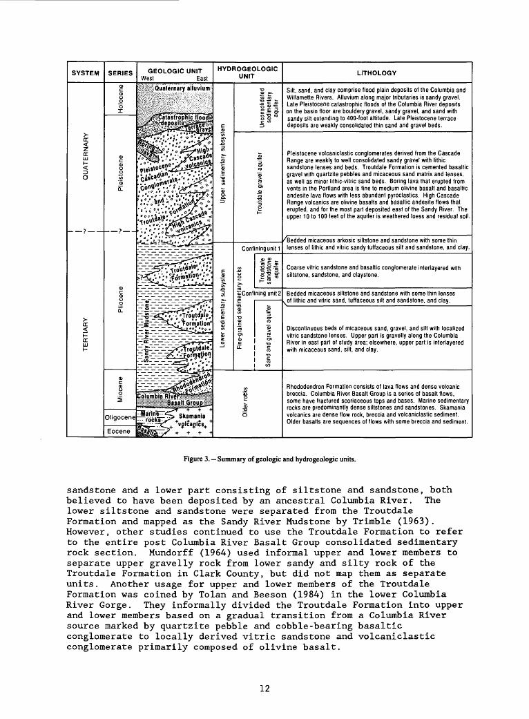
The detailed subsurface mapping in the Portland well field indicated that the relation between the Sandy River Mudstone and the Troutdale Formation may be more complex than originally described by Trimble (1963). In the Portland well field area and other parts of the basin, the fine and coarse-grained lithologies of these two formations interfinger with one another as shown in figure 3. Coarse-grained facies typical of the Troutdale Formation are thickest in the east and southeastern part of the basin and fine facies of the Sandy River Mudstone are more dominant toward the west.
Along the eastern margin of the basin, the Sandy River Mudstone underlies the ancestral Columbia River channel gravels and vitric sandstones of the Troutdale Formation. However, lenses of silt, micaceous sand, and ash, similar in lithology to the Sandy River Mudstone, are interlayered with the Troutdale Formation along the Sandy River and near the Clackamas River. Well cuttings and geophysical logs from southern Clark County and the Sandy-Damascus area also indicate that the Sandy River Mudstone is interlayered with vitric sandstone beds in the the Troutdale Formation.
Trimble (1963) named the Sandy River Mudstone for Pliocene age beds of mudstone, siltstone, claystone, and sand that were formerly referred to as the lower part or member of the Troutdale Formation (Trimble, 1957). Extensive exposures of this formation outcrop along the Clackamas and Sandy Rivers. In Clark County, similar sandy rocks are exposed along the East Fork of the Lewis River and in its lower tributaries. The Sandy River Mudstone thickens toward the center of the basin to a maximum thickness that may be as much as 1,400 feet at the deepest part of the Portland Basin.
The Sandy River Mudstone is composed chiefly of micaceous arkosic siltstone and fine- to medium-grained sand with minor gravelly lenses. Clay and water-laid ash layers also are present in outcrops along the Sandy and Clackamas Rivers. Many of the siltstones are massive appearing or interbedded with thin beds of fine sand. Silty sand beds show cross-stratification and ripples. Where the Sandy River Mudstone is exposed along the Sandy River and Clackamas River, it contains weakly-consolidated, medium-grained, micaceous, arkosic sand beds that range from a few inches to 10 or 15 feet in thickness. These sand beds have planar- and cross-stratification and sometimes exhibit massive structure. Similar micaceous arkosic sand beds up to 50 feet thick are exposed along the East Fork Lewis River. Lithologic descriptions from wells that penetrate below the Troutdale Formation in Clark County show sand beds that are commonly more than 50 feet thick. Vitreous carbonized wood as well as woody fragments are found throughout the Sandy River Mudstone and plant fossils are common in silty and clayey layers. Fossil plant assemblages near the Sandy River Mudstone- Troutdale Formation transition were used by Trimble (1963) to assign a Pliocene age to the Sandy River Mudstone.
The Troutdale Formation has been described in various ways and with varying terminology by previous workers. Hodge (1938) referred to the Troutdale Formation as conglomerate, sandstone, and siltstone deposits exposed along the lower Sandy River near the town of Troutdale, Oregon. Hodge's (1938) type area for the Troutdale Formation includes two distinct lithologic facies; an upper part consisting of chiefly quartzite-bearing basaltic conglomerate and coarse hyaloclastic
11
SYSTEM
> cc <z ccLU (- <Z3 O
>-cc <H ccLU(-
SERIES
Q)C 0)u £ oI
0)c0)u o u> '(1)
Q.
0)c0)u0
Q.
Miocene
Oligocene
Eocene
GEOLOGIC UNITWest East
Quaternary alluviumi^lfciiSPiiiSSfliH ililS;i:IiSfflW?:$Mi:Wi; &£ilSIWIsKKKMSvil
sssjp^Catastrppfiic floocR
s~-T~Irrl^' Forrr(ation°
J^§^$
^ili^^i* <^^S?** * +*
HYDROGEOLOGIC UNIT
0>
J3
5o>,E
o>
<£Q. Q.
E
2 o>
^E
o>
io
Unconsolidated sedimentary aquifer
o-CO
CO
o>CO
"3o
Confining unit 1
0 ° C of
cConfiningunit2
Fine-grained sedir Sand and gravel aquifer
o
6
LITHOLOGY
Silt, sand, and clay comprise flood plain deposits of the Columbia and Willamette Rivers. Alluvium along major tributaries is sandy gravel. Late Pleistocene catastrophic floods of the Columbia River deposits on the basin floor are bouldery gravel, sandy gravel, and sand with sandy silt extending to 400-foot altitude. Late Pleistocene terrace deposits are weakly consolidated thin sand and gravel beds.
Pleistocene volcaniclastic conglomerates derived from the Cascade Range are weakly to well consolidated sandy gravel with lithic sandstone lenses and beds. Troutdale Formation is cemented basaltic gravel with quartzite pebbles and micaceous sand matrix and lenses, as well as minor lithic-vitric sand beds. Boring lava that erupted from vents in the Portland area is fine to medium olivine basalt and basaltic andesite lava flows with less abundant pyroclastics. High Cascade Range volcanics are olivine basalts and basaltic andesite flows that erupted, and for the most part deposited east of the Sandy River. The upper 10 to 100 feet of the aquifer is weathered loess and residual soil.
/Bedded micaceous arkosic siltstone and sandstone with some thin lenses of lithic and vitric sandy tuffaceous silt and sandstone, and clay.
Coarse vitric sandstone and basaltic conglomerate interlayered with siltstone, sandstone, and claystone.
Bedded micaceous siltstone and sandstone with some thin lenses
Discontinuous beds of micaceous sand, gravel, and silt with localized vitric sandstone lenses. Upper part is gravelly along the Columbia River in east part of study area; elsewhere, upper part is interlayered with micaceous sand, silt, and clay.
Rhododendron Formation consists of lava flows and dense volcanic breccia. Columbia River Basalt Group is a series of basalt flows, some have fractured scoriaceous tops and bases. Marine sedimentary rocks are predominantly dense siltstones and sandstones. Skamania volcanics are dense flow rock, breccia and volcaniclastic sediment. Older basalts are sequences of flows with some breccia and sediment.
Figure 3. Summary of geologic and hydrogeologic units.
sandstone and a lower part consisting of siltstone and sandstone, both believed to have been deposited by an ancestral Columbia River. The lower siltstone and sandstone were separated from the Troutdale Formation and mapped as the Sandy River Mudstone by Trimble (1963). However, other studies continued to use the Troutdale Formation to refer to the entire post Columbia River Basalt Group consolidated sedimentary rock section. Mundorff (1964) used informal upper and lower members to separate upper gravelly rock from lower sandy and silty rock of the Troutdale Formation in Clark County, but did not map them as separate units. Another usage for upper and lower members of the Troutdale Formation was coined by Tolan and Beeson (1984) in the lower Columbia River Gorge. They informally divided the Troutdale Formation into upper and lower members based on a gradual transition from a Columbia River source marked by quartzite pebble and cobble-bearing basaltic conglomerate to locally derived vitric sandstone and volcaniclastic conglomerate primarily composed of olivine basalt.
12

The term "Troutdale Formation'1 as used in this report refers strictly to the Columbia River drainage-basin-derived quartzite pebble- bearing and cobble-bearing basaltic conglomerate and interbedded fluvial vitric sandstone of the Troutdale Formation type area.
The Troutdale Formation ranges in thickness from between 75 and 400 feet. Vitric sandstone and gravels interfinger with the Sandy River Mudstone throughout much of the Portland Basin. The conglomerate beds are probably channel deposits deposited along the course of an ancestral Columbia River in a subsiding Portland Basin. The vitric sandstone beds overlie the channel gravel in some areas and are more sheet-like in their distribution. The vitric sandstone beds are thickest in the southeastern part of the basin and thin toward the center. Well data indicate that these sandstones pinch out in the westernmost parts of the basin.
Trimble (1963) assigned a Pliocene age to the Troutdale Formation on the basis of fossil-plant assemblages taken from the upper part of the Sandy River Mudstone and fine-grained beds in the lower part of the Troutdale Formation. Although this is the accepted age for much of the Troutdale Formation in the Portland Basin, the age of the unit probably ranges from late Miocene to late Pliocene or early Pleistocene on the basis of K-Ar (potassium-argon) rock ages of volcanic rocks that underlie, interlayer with, or overlie the Troutdale Formation (Tolan and Beeson (1984). Troutdale Formation conglomerates fill an ancestral Columbia River canyon cut into middle Miocene, Columbia River Basalt Group flows. Troutdale Formation conglomerates are interlayered with lahar beds correlated with the late Miocene Rhododendron Formation (Tolan and Beeson, 1984). Cascade volcanic lava flows overlying the Troutdale Formation have been K-Ar dated at less than 1.5 million years (Hammond and Korossec, 1983).
Cascade Range Volcanics and Boring Lava
The Cascade Range volcanics (fig. 2) and Boring Lava are compositionally similar and genetically related Pliocene and Quaternary basalt and basaltic andesite flows and breccias. The Cascade volcanics form a platform along the crest of the Cascade Range (High Cascades) in Oregon and southern Washington with thicknesses over 3,000 feet (Peck and others, 1964; Walsh and others, 1987). The Boring Lava is considered a western outlier of Cascade Range.volcanics in the Portland Basin and Tualatin Mountains (Peck and others, 1964) and is the westernmost extent of Cascade Range volcanics in Oregon and Washington. In this report, the term Boring Lava (Treasher, 1942) refers to localized accumulations (in some areas more than 400 feet thick) of Cascade volcanics erupted from vents in the greater Portland area and in Clark County. Cascade volcanics form a wedge of Pliocene and Quaternary basalt and basaltic andesite that thickens east of the Sandy River. The source of the fluvial vitric sandstones in the Troutdale Formation was Cascade volcanics basalt erupted into surface waters and redeposited by the ancestral Columbia River system (Tolan and Beeson, 1984; Swanson, 1986).
13

Late Pliocene to Holocene Sediments
Cascadian Volcaniclastic conglomerate, loess, terrace deposits, catastrophic flood deposits, and alluvium of late Pliocene to Holocene age mantle much of the Portland Basin.
Volcaniclastic conglomerate derived from the Cascade Range and sandstone overlie the Troutdale Formation and Sandy River Mudstone, and interlayer with and overlie the Boring Lava in Multnomah and northern Clackamas Counties. These Volcaniclastic conglomerates have been mapped as Troutdale Formation in some parts of the basin. In eastern Clark County, Mundorff (1964) mapped similar rocks that cap hills as Troutdale Formation. In Oregon, Trimble (1963) mapped similar units as the Walters Hill, Springwater, and Gresham Formations. These conglomerates are 100 to 200 feet thick and consist of cemented, pebble-cobble gravel with bouldery areas and lenses. Volcanic tuff and breccia are locally interbedded with these conglomerates and sandstones. In some places, there is a thick, weathered zone on the Volcaniclastic conglomerates derived from the Cascade Range up to 100 feet thick.
Loess deposits (Trimble, 1963), also referred to as the Portland Hills Silt (Lowrey and Baldwin, 1952), are brown, micaceous, clayey, eolian silt of Pleistocene age (Lentz, 1981). These deposits are thickest (40 to 120 feet) where they mantle the Tualatin Mountains and parts of the Boring Lava southeast of Portland (Trimble, 1963; Lentz, 1981); however, thinner deposits (5 to 20 feet thick) probably mantle much of the study area. These loess deposits interlayer and overlie Boring Lava in the Tualatin Mountains (Lentz, 1981) and overlie the Cascadian Volcaniclastic conglomerate. Below 300 to 400 feet altitude, the loess deposits are removed or covered by the fine-grained facies of the catastrophic flood deposits of the Columbia River.
Terrace deposits along most major rivers in the Portland area are of limited extent and consist of Pleistocene volcanic gravels, felsic lithic sand, and Cascades Range volcanic derived debris flows. These deposits are lithologically similar to the Volcaniclastic conglomerate unit that overlies the Troutdale Formation. The terrace deposits are usually not more than 50 to 75 feet thick. Many exposures consist of thin veneers on valley walls with little lateral extent.
In northern Clark County, late Pleistocene and Holocene mudflow and pyroclastic debris deposits from Mount St. Helens' eruptions cover parts of the Lewis River valley floor and walls (Major and Scott, 1988). Unique to northern Clark County are small isolated basins of upper Pleistocene glacial outwash deposits (Mundorff, 1964). For example, in Chelatchie Prairie and the Yacolt Basin as much as 250 feet or more of predominately sand and gravel deposits underlie the valley floors (Mundorff, 1964).
Large quantities of Pleistocene sediments were deposited by catastrophic floods of the Columbia River that occurred in the late Pleistocene. Periodic failure of ice dams impounding huge lakes in Idaho and Montana caused a series of as many as 40 colossal floods of the Columbia River (Bretz and others, 1956; Waitt, 1985). A constriction in the Columbia River valley at the the north end of the Portland Basin caused the flood waters to fill the Willamette Valley and
14
Portland area to an altitude of about 400 feet. These episodes of flooding deposited bouldery gravel, gravely sand, sand, and sandy silts that mantle the Willamette Valley and Portland Basin to altitudes of 350 to 400 feet (Trimble, 1963). In addition to depositing significant quantities of sediment, catastrophic flood waters eroded large parts of exposed rock units.
The catastrophic flood deposits can be grouped into two easily discernable lithologic units. A basaltic sand and gravel unit with varied amounts of cobbles and boulders (some to over 12 feet in diameter) and a finer, stratified, micaceous arkosic sand, silt, and clay. The coarse unit is found near the present channel of the Columbia River in southern Clark County and the Portland area. There also appears to be similar coarse flood deposits beneath Sauvie Island. Thickness of the gravel ranges from a few feet to more than 200 feet in local areas. These coarse-grained flood deposits constitute the most permeable aquifer in the Portland Basin. Away from the Columbia River flood plain, the coarse-grained flood deposits tend to be largely unsaturated where they are present. The finer unit exists at an altitude of about 250 feet throughout the study area and ranges in thickness from 20 feet to about 100 feet.
Alluvium exists along all major streams in the Portland Basin with the most extensive deposits along the Columbia and Willamette Rivers. The Columbia and Willamette River alluvium is chiefly sand and silt, whereas alluvium of the major tributaries is mostly cobble gravel. The Lewis River and Sandy River valleys include finer mudflow and reworked mudflow deposits from Mount St. Helens and Mount Hood respectively (Major and Scott, 1988; Crandell, 1980). Mount St. Helens is located north of the study area and Mount Hood is east of the study area (fig. 2).
GEOLOGIC STRUCTURE
Northwest and northeast trending topographic lineations, faults, and folds are present throughout the Portland Basin (sheet 1). One of these structures is the northwest trending Portland Hills-Clackamas River fault zone, described by Beeson and others (1985), that bounds the Portland Basin on the west and south. Eocene to Miocene volcanic and sedimentary rocks form topographic highs that predate deposition of the Columbia River Basalt Group and younger sediments. The older volcanic rocks, marine rocks, and Columbia River basalts underlie the basin-fill sediments and are offset downward into the basin by poorly defined faults. Basin-filling sedimentary rocks were deposited as a broad, shallow basin formed. Small faults and folds deform these sediments, appearing to be both contemporaneous with and subsequent to deposition of the basin-filling sediment. Major geologic structures mapped in the basin are shown on sheet 1.
Geologic structure is difficult to map in most of the older volcanic and marine rocks because they are thickly bedded and lack distinctive marker beds or, in the case of marine beds, are subject to landsliding. However, some major faults have been identified. The oldest volcanic rocks, the basalts of Waverly Heights, Goble Volcanics, and Skamania Volcanics, form topographic and structural highs that
15

younger units lap up against or drape over. Prune Hill in southeastern Clark County, and the Tryon Creek area near Lake Oswego are examples of older rock highs.
Mundorff (1964) and Phillips (1987b) mapped several major faults that form linear fault-bounded valleys within the Skamania Volcanics in Clark County. One of the most prominent in the northeast Clark County area is the Chelatchie Prairie fault zone which trends north, 70 degrees east, and bounds the south end of Chelatchie Prairie. Another in the same area is the Yacolt Basin fault. The Yacolt Basin fault trends north, 35 degrees west, intercepts the Chelatchie fault zone and appears to extend 10 or more miles to the southeast as a lineation (sheet 1).
The Skamania Volcanics are also displaced by major faults in the Camas and Washougal areas of Clark County. Along Lacamas Lake and lowermost Lacamas Creek, vitric sandstone in the Troutdale Formation appears to be in fault contact with Skamania Volcanics to the northeast. Along the southwest side of Prune Hill, the Skamania Volcanics appear to be displaced more than 1,600 feet by a significant northwest trending fault zone. This structure also offsets vitric sandstone in the Troutdale Formation by as much as 500 feet. Several studies using gravity geophysical investigations have identified areas of structural deformation at the margins of the Portland Basin. Geophysical models indicate a sharp density change between older rocks and the basin filling sediments (Beeson and others, 1975; Perttu, 1980; Davis, 1987).
The stratigraphy and structure of the Columbia River Basalt Group has been mapped in detail along the Tualatin Mountains (locally referred to as the Portland Hills) [Beeson and others, 1989] on the basis of variation of rock geochemistry, magnetic stratigraphy, and lithology. The Tualatin Mountains are a complexly-faulted anticlinal fold. Similar structures also may be present within the basin, but are unknown because of basin-filling sediments. Lithologic records and drill cuttings from several wells just north of the Clackamas River reveal two anticlinal structures in the Columbia River Basalt Group. One anticline is just southeast of Damascus and the other, the Tickle Creek anticline, is a northwest trending anticlinal ridge between Tickle Creek and Deep Creek.
Some geologic structures in the Sandy River Mudstone, Troutdale Formation, Boring Lava, and volcaniclastic conglomerate were identified from stratigraphic relations and lithologic data from wells; however, data are too sparse to identify all folds and faults in these units. In general, the Sandy River Mudstone, Troutdale Formation, and volcaniclastic conglomerate dip gently toward the center of the basin, suggesting that sediments accumulated as the basin subsided. Geologic structures observed in the older rocks are carried through into the overlying Sandy River Mudstone, Troutdale Formation, and volcaniclastic gravel. Younger rocks thin over structural highs of older rocks and in some cases show small amounts of displacement upward through the section, suggesting that these structures were active while the basin- filling sediments were being deposited. Prune Hill, Tickle Creek anticline, a Boring Lava capped ridge southeast of Damascus (sheet 1) and an unnamed series of low ridges in western Clark County are examples.
16
Structural deformation appears to have taken place at the time of emplacement of the basalt and pyroclastic rocks of the Boring Lava. The volcaniclastic conglomerates underlying, interlayering, and overlying the Boring Lava are uplifted and downdropped slightly as fault bounded blocks southeast of Portland. Eruptive vents formed along a northeast trending fault along the west margin of the Boring Lava north of Carver, Oregon. The lavas were intruded and extruded in the downdropped block that underlies Pleasant Valley.
HYDROGEOLOGIC UNITS
The flow of ground water through an aquifer system and, therefore, the availability of ground water is dependent largely on the extent and thickness of relatively good water-bearing units, or aquifers, and of relatively poor water-bearing units, called confining units. These aquifers and confining units are referred to as "hydrogeologic units" in this report because they are mapped on the basis of their geologic and water-bearing characteristics. A hydrogeologic unit may include several geologic units or formations with similar water-bearing characteristics or may include a single part of a geologic unit with a distinct water-bearing characteristic.
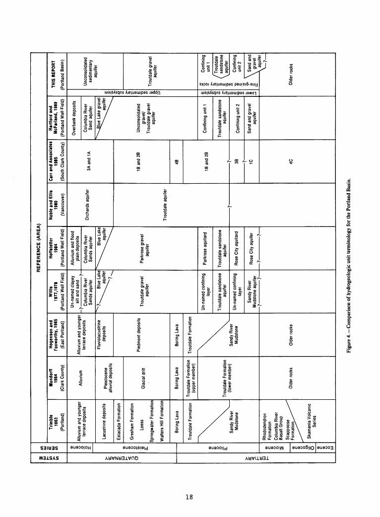
In this study, the hydrogeologic units described by Hartford and McFarland (1989) and older hydrogeologic units were mapped throughout the basin on the bais of geologic mapping, lithologic descriptions by drillers, geophysical data, examination of drill cuttings, specific- capacity tests, and water levels in wells. Comparisons of hydrogeologic units with geologic units described earlier in this report are shown in figure 3. A chart comparing hydrogeologic units mapped in this study with other workers' stratigraphic and hydrogeologic units is shown in figure 4.
In previous regional scale ground-water studies in the Portland Basin (Mundorff, 1964; Hogenson and Foxworthy, 1965), water-bearing characteristics of each geologic formation were described. However, more recent studies have used a significant amount of new well data to map multiple hydrogeologic units in the Troutdale Formation and the Sandy River Mudstone (Willis, 1977; Willis, 1978; Hoffstetter, 1984; Hartford and McFarland, 1989). Late Pleistocene to Holocene Columbia River sediments also have been mapped by water-bearing characteristics locally, but it is not practical to separate these localized units in a regional s tudy.
Eight major hydrogeologic units form the Portland Basin aquifer system. From oldest to youngest they include: older rocks, sand and gravel aquifer, confining unit 2, Troutdale sandstone aquifer, confining unit 1, consolidated gravel aquifer, and the unconsolidated sedimentary rock aquifer. The eighth unit (undifferentiated fine-grained sediments) exists in areas of the basin where the Troutdale sandstone aquifer and the sand and gravel aquifer pinch out or there is insufficient information to characterize the aquifer units within the fine-grained Sandy River Mudstone (or lower member of the Troutdale Formation of Mundorff, 1964). In those areas, confining units 1 and 2 cannot be separated and therefore are mapped singly as undifferentiated fine-grained sediments. The location of hydrogeologic units that are exposed at land surface is shown on plate 1, and hydrogeologic sections in the basin are shown on plate 2.
17
81
TERTIARYQUATERNARYSYSTEM
Eocene Oligocene MiocenePliocenePleistoceneHoloceneSERIES
CD CO.
i-11
ndy ton
CD 0 ^
CD X. a coo o
3- 10 gs si
0 <BT3 S 30 S
a>oco 9.
."
a. - 3:
f 5 ? at Q _g
Oo
^
Lower sedimentary subsystem
Fine-grained sedimentary rocks
= i a. 3w S1
Upper sedimentary subsystem

For discussion purposes, the aquifer system can be grouped into three major subsystems (fig. 3) on the basis of regionally continuous contacts between units or groups of units of distinctly different lithologic and hydrogeologic characteristics. These aquifer subsystems are the older rocks, the lower sedimentary rocks, and the upper sedimentary rocks.
A series of maps (pis. 3-10) show the altitude of the top and thickness of the hydrogeologic units in the basin. These maps are discussed in the following descriptions for each unit. Interpretations of hydrogeologic units in individual wells are listed in table 1 at the back of the report. These data can be cross-referenced to well data from well-drillers' reports (McCarthy and Anderson, 1990).
Older Rocks Subsystem
The older rocks subsystem includes Miocene and older volcanic and marine sedimentary rocks of generally low permeability that underlie and bound the basin-filling sediments in the Portland Basin. The contact between the older rocks and basin-filling sediments can be easily interpreted in many wells that penetrate both units. With the exception of the Columbia River Basalt Group and the Rhododendron Formation, these older rocks are poor aquifers and, in most areas, only supply water adequate for domestic uses. These rocks are not a primary source of water in many parts of the study area. Much of the area, where the older rocks are exposed at land surface, is sparsely populated forest uplands with some farmland or urbanized areas served by public water supplies. Where they are covered by basin-filling sediments, the older rocks generally are too deep to be used as a water supply under the current demand for water.
The Skamania Volcanics, Goble Volcanics, and basalts of Waverly Heights Formation are all dense altered volcanic rocks with little capacity to store or transmit water. Wells in these units yield about 5 to 10 gallons per minute. The Skamania Volcanics and, to a lesser degree, the Goble Volcanics increasingly are being used as residential development moves into the foothills of the Cascade Range. Wells drilled into the fractured zones and to the soil/rock interface may be the best producers.
Marine sedimentary rocks such as the Scappoose Formation also have limited water-bearing capabilities and in some areas contain saline water. In the Tualatin Valley, ground water derived from marine sedimentary rocks underlying the Columbia River Basalt Group have chloride contents of more than 1,800 milligrams per liter (hart and Newcomb, 1965). Most wells in these older rocks generally have yields from 5 to 10 gallons per minute.
The Columbia River Basalt Group is used as an aquifer along the western and, to a lesser extent, southern boundaries of the Portland Basin where it crops out or is not overlain by thick sedimentary rock aquifers. Large capacity wells in the Columbia River Basalt Group typically are open to several hundred feet of the unit in order to penetrate one or more productive interflow zones. Within the study area, several wells completed in the Columbia River Basalt Group are capable of producing over 1,000 gallons per minute.
19

Although the Columbia River Basalt Group has the capability in places to produce large quantities of ground-water, its limited capacity to store water is evident in many parts of western Oregon. Water-level declines have occurred in several upland areas of the Willamette Valley in Oregon as a result of overdevelopment of aquifers in the basalts.
The Rhododendron Formation underlies the extreme southeastern part of the study area and produces ground water for domestic use and small- scale irrigation. The Rhododendron Formation is principally lava flows and consolidated volcanic debris. Leonard and Collins (1983) report that the most productive wells were completed in material described as lava or rock by drillers. Well yields of 5 to 25 gallons per minute are typical for the Rhododendron Formation.
Older rocks in the Portland Basin (pis. 2 and 3) form a broad northwest trending depression with a maximum depth of about 1,600 feet. The altitude of the top of the older rocks, where overlain by basin- filling sediments, is shown on plate 3. The contour map of altitude of the top of the older rocks are based primarily on available well data and geological mapping in the basin. Most of the wells that penetrate the older rocks are along the edge of the basin where the older rocks are shallow and the overlying sediments are thin. Only a few wells penetrate the older rocks where overlying sediments are more than 500 feet thick. Wells that do not penetrate the older rocks also give control points for the top of the unit by identifying the minimum thickness of sediments above older rocks. The altitude of the top of the unit, in this case, is known to be less than the altitude of the bottom of the well.
Several geophysical studies have been conducted in the Portland Basin (Perttu, 1980; Davis, 1987; and Beeson and others, 1975). Interpretations from those studies were used to assist with mapping the altitude of the top of the older rocks.
Plate 3 shows that the center of the basin is approximately located beneath Vancouver, Washington, at an altitude of about minus 1,600 feet. This estimate of the top of the older rocks is based largely on wells that do not penetrate bedrock. Projection of the approximate dip of the older rock/basin-filling sediment contact, as indicated in wells close to the contact near the margin of the basin, was assumed to be less steep toward the center of the basin .
Areas of the basin with the best control on the altitude of the older rocks beneath the basin-fill sediments include: downtown Portland, Milwaukie/Lake Oswego, Damascus, Tickle Creek, and the area near Blue Lake. In these areas, sufficient well data allow somewhat detailed mapping of the subsurface structure. In the Damascus and Tickle Creek areas, structural highs in the Columbia River Basalt Group were located with well data that were not available in earlier studies. Near Blue Lake, wells have been drilled to depths greater than 1,000 feet below sea level and did not penetrate the older rocks; however, Skamania Volcanics outcrop approximately 1.5 miles northeast of the Blue Lake area. Although the wells in that area do not penetrate the older rocks, their depth and proximity to outcrops give reasonable control on the altitude of the older rock/basin-filling sediment contact.
20

In the southeastern part of the study area, outcrops in canyons and few field-located wells provide reasonable control on the altitude of the top of the older rocks.
A few small isolated, sediment-filled subbasins occur in the study area which are not part of the main structural basin. These basins are in the Chelatchie Prairie/Yacolt area of northeastern Clark County, the Bear Prairie area of southeastern Clark County, and a basin just northwest of St. Helens, Oregon. These basins are relatively shallow and are generally related to geologic structures in the older rocks.
Lower Sedimentary Subsystem
The lower sedimentary subsystem extends basin wide and overlies the older rocks. It is composed of: (1) interbedded consolidated silt, sand, and clay which are characteristic of Trimble's (1963) Sandy River Mudstone and Mundorff's (1964) lower member of the Troutdale Formation, and (2) interlayered vitric sandstone and quartzite pebble-bearing basaltic conglomerate that characterize the Troutdale Formation in its type area in the lower Sandy River canyon. The lower sedimentary subsystem was divided into two aquifers and two confining units in the southeastern part of the basin where the vitric sandstone and channel gravel deposits of the ancestral Columbia River are interlayered with the Sandy River Mudstone. Where data permit, the lower sedimentary subsystem is mapped into a sand and gravel aquifer, a lower confining unit 2, the Troutdale sandstone aquifer, and an upper confining unit 1. Toward the western side of the basin, the Troutdale sandstone and the sand and gravel aquifer become finer grained and apparently pinch out. In these areas, confining unit 2 and confining unit 1 are not distinguishable from each other and the lower sedimentary subsystem is mapped as undifferentiated fine-grained sedimentary rocks. Throughout most of the basin, the contact between confining unit 1 or the undifferentiated fine-grained sediments and the overlying consolidated gravels is easily mapped.
Sand and Gravel Aquifer
The sand and gravel aquifer is the lowermost hydrogeologic unit within the lower sedimentary subsystem (pis. 2 and 4). Where it is present, this aquifer is defined by the total sediment thickness between the top of the aquifer and the top of the older rocks. This sediment interval consists of principally sandy gravel, silty sand, sand, and clay. Where it is described in the Portland well field (Hartford and McFarland, 1989), the sand and gravel aquifer has a relatively coarse grained upper subunit and a predominately fine-grained lower subunit that extends to the base of the sedimentary rock section. This hydrogeologic unit is considered a relatively coarse-grained facies of the Sandy River Mudstone and Mundorff's (1964) lower member of the Troutdale Formation.
The upper subunit consists of micaceous arkosic sand, vitric-lithic sand, sandy gravel, and silt. In the eastern part of the Portland well field, the upper subunit is a conglomerate with basaltic clasts in a sandy matrix overlain by vitric sandstone. The subunit is more than 200 feet thick and tends to become more sandy upward and toward the western part of the Portland well field. Outside the Portland well field and
21
Troutdale areas, the vitric sand upper part of the subunit cannot be recognized. The lower subunit is predominantly fine- to medium-grained micaceous quartzose sand with silt and clayey silt interbedded with minor lenses of basaltic sand mixed with micaceous arkosic sand.
In general, available well data suggest that the sand and gravel aquifer is coarsest near the present Columbia River channel. Sand and sandy gravel beds were probably deposited by an ancestral Columbia River.
Although the sand and gravel aquifer is well defined along the south shore of the Columbia River east of Portland by Hartford and McFarland (1989), its extent is poorly defined elsewhere because few deep wells penetrate the unit. The top and thickness of the sand and gravel aquifer are shown on plate 4.
The sand and gravel aquifer exists near the present Columbia River channel and extends from the Columbia River Gorge area (fig. 2) on the east to western edge of 1N/2E (pi. 4). Although most of the aquifer is identified in Oregon, two areas of Clark County, Washington are underlain by this unit. One area is along the north shore of the Columbia River, east of Vancouver, in the Prune Hill/Lacamas Lake area, and the second area includes sandy gravels that underlie the Mount Norway area.
The altitude of the top of the sand and gravel aquifer is highest in the Prune Hill/Lacamas Lake and the Mount Norway areas. In those areas, the top of the unit reaches altitudes of about 400 and 700 feet, respectively. Areas east of the Sandy River in Oregon also are underlain by the sand and gravel aquifer at a relatively high altitude of 500 feet.
In these upland areas of Clark and Multnomah Counties, the sand and gravel aquifer is tapped only by a few domestic water supply wells. At the higher altitudes, these sands and gravels may not be saturated.
From upland areas to the north and east, the top of the unit generally dips westward and is at its lowest altitude of about minus 600 feet northwest of Gresham. In the Portland well field, where the unit is best defined and described, the altitude of the top of the sand and gravel aquifer ranges from about minus 100 feet near Blue Lake to approximately minus 500 feet beneath the Portland International Airport.
The contours on the top of the sand and gravel aquifer, in areas such as those beneath the Columbia River, may represent an erosional and structural surface; however, this surface may represent only a structural surface in other areas. Between the Gresham and Blue Lake area, for example, the contours may indicate the presence of anticlinal and synclinal structure in the sand and gravel aquifer.
The thickness of the sand and gravel aquifer is generally least where the unit laps up against the older rocks in the upland areas and thickest near the center of the basin where it exceeds 800 feet.
22
The areal extent of the coarse-grained deposits in the unit is shown in plate 4. Hydrogeologic sections in plate 2 illustrate the facies changes that apparently limit the extent of the sand and gravel aquifer. Future deep well drilling in the basin may help refine the subsurface mapping of the unit.
The sand and gravel aquifer is developed chiefly by public-supply systems along the south shore of the Columbia River between Interstate 5 and the Sandy River Portland Bureau of Water Works supply wells, which are open solely to the sand and gravel aquifer, can yield 2,000 to 3,000 gallons per minute. One Troutdale public-supply well, open only to the sand and gravel aquifer, was tested at a discharge of 590 gallons per minute with 52 feet of drawdown after 24 hours. Several domestic wells, in the low hills between the Washougal River and Columbia River, draw water from a sandy conglomerate which is included in the sand and gravel aquifer. These wells yield 5 to 30 gallons per minute.
Confining Unit 2
Confining unit 2 overlies the sand and gravel aquifer and underlies the Troutdale sandstone aquifer where the two aquifers are present (pi. 2). Hartford and McFarland (1989) describe confining unit 2 in the Portland well field as greyish olive-green clay and silt with lenses of silt and fine-to-medium-grained basaltic sand. Outcrops of this unit are limited to the southeastern part of the basin along the Clackamas and Sandy Rivers in Oregon.
The altitude of the top and thickness of confining unit 2, where the Troutdale sandstone aquifer is present and where the sand and gravel aquifer may or may not be present, is shown in plate 5. The altitude of the top of confining unit 2 is highest just east of the Sandy River and in the Tickle Creek area in Oregon. In these areas, the top of the unit is ac altitudes of about 900 feet. From the southeastern part of the basin, the top of the unit generally dips toward the center of the basin to an altitude of about minus 500 feet. In Clark County, Washington, the altitude of the top of the unit is about 500 feet in the Prune Hill area, but is generally between sea level and about minus 400 feet toward the center of the basin. Geologic structures, as well as erosional features, are evident from contours on the top of and the extent of confining unit 2 (pi. 5). For example, a high in the unit is shown on the Tickle Creek anticline and an erosional east-facing "v-shaped" outcrop is mapped where the Columbia River cuts across the updip edge of the unit.
Where the Troutdale sandstone aquifer is present, but the sand and gravel aquifer is not mapped, the thickness of confining unit 2 is much greater. An abrupt change in thickness is shown on sheet 5 outside the extent of the sand and gravel. This is because the fine-grained facies equivalent to the sand and gravel aquifer has been included in confining unit 2 in that area. The thickness of confining unit 2 ranges from approximately 200 feet in the southeastern part of the basin to more than 800 feet toward the center of the basin. Around the basin margin, the unit ends where it thins against older rocks. Near the Columbia River, confining unit 2 is generally less than 200 feet thick and average thickness is between 40 and 100 feet.
23

Confining unit 2 is used for a water supply only where more permeable units are not present. Lenses of silt and fine-grained sand 2 to 6 feet thick in the unit can supply water for domestic uses. Confining unit 2 limits vertical flow in the aquifer system and partly confines the sand and gravel aquifer.
Troutdale Sandstone Aquifer
The Troutdale sandstone aquifer (pis. 2 and 6) consists of coarse grained vitric sandstone and conglomerate with lenses and beds of fine to medium sand and silt. The aquifer is underlain by confining unit 2 and overlain by confining unit 1 throughout much of its extent. Where the aquifer is not present, the two confining units cannot be differentiated.
The Troutdale sandstone aquifer was first described in the Portland well field by Willis (1977, 1978). Hartford and McFarland (1989) described the lithology and mapped the extent of the unit in the Portland well field and nearby area, and correlated the vitric sandstone outcrops south of Blue Lake with the aquifer. Swanson (1986, 1988) correlated the unit with fluvial deposits in the Troutdale Formation along the Sandy River and lower Columbia River Gorge on the basis of the chemistry and lithology of the vitric sand grains.
The Portland well field area was considered the type area for the Troutdale sandstone aquifer. Geologic mapping and correlation of lithologic records from water wells indicate that the Troutdale sandstone aquifer mapped by Hartford and McFarland (1989) extends to the type area of the Troutdale Formation near Troutdale, Oregon. Further geologic mapping and correlation of well records indicate that the vitric sandstone and the vitric sandstone-bearing conglomerate of the Troutdale Formation form a distinct, discernable unit throughout most of the southeastern and south central Portland Basin.
Hartford and McFarland (1989) described the Troutdale sandstone aquifer as consisting of two lithologic subunits; the upper two-thirds is chiefly vitric sandstone and the lower one-third is conglomerate. The upper vitric sandstone consists of moderately- to well-sorted angular to subround coarse sand of black to dark-brown olivine basalt glass and dark-gray olivine basalt. Lenses of sandy silt and clay are interlayered with the vitric sandstone. The lower conglomerate consists of quartzite-bearing basaltic conglomerate with a matrix of vitric sand and micaceous lithic arkose.
In outcrops, samples of the Troutdale sandstone aquifer usually appear much more weathered and, in some cases, more cemented than those encountered in well cuttings in the Portland Basin. Outcrops range in color from nearly black to deep reddish brown to orange, indicating increasing degrees of weathering. Weathering from basaltic glass to clays, zeolites, and opal is probably most rapid above the water table (Hay and lijima, 1968). The unweathered glassy appearance of most well cuttings of vitric sand suggests that the sands were buried and saturated before appreciable weathering took place.
24

Locally, the Troutdale sand&tone aquifer in the basin contains channel conglomerates and sequences of 20- to 30-foot thick vitric sandstone beds that grade upward into medium-grained feldspar, quartz sand, and siltstone.
The Troutdale sandstone aquifer is most extensive in the southeastern part of the basin and crops out along streams in that area. Streams near the towns of Troutdale, Sandy, and Boring, Oregon cut through the aquifer, and in some areas significant seepage occurs from the aquifer to the streams. The aquifer also crops out just north of the City of Camas, in Clark County, Washington. The altitude of the top and thickness of the Troutdale sandstone aquifer are shown in plate 6.
The altitude of the top of the aquifer is about 1,000 feet in the area east of the Sandy River and dips westward to an altitude of about minus 400 feet just a few miles east of downtown Portland. The contours on the top of the unit show structure and erosional features similar to those described for confining unit 2.
The thickness of the Troutdale sandstone aquifer is generally from 100 to 200 feet but may reach 400 feet in the southeastern part of the basin. The thickest part of the aquifer is east of the Sandy River, close to the source area for the sediments that comprise the unit. The aquifer is generally thinner to the west and northwest and interfingers with undifferentiated fine-grained sediments near the center of the basin (pi. 2).
Sandstones and conglomerates of the Troutdale sandstone aquifer are excellent water-bearing units just west of the mouth of the Columbia River Gorge and, to a lesser degree, in the Damascus and Boring, Oregon areas. Large-capacity wells in the Portland well field have been tested at up to 2,500 gallons per minute. Other smaller-capacity municipal, industrial, and irrigation wells open to the Troutdale sandstone aquifer may yield more than 500 gallons per minute.
Confining Unit 1
Confining unit 1 (pis. 2 and 7) is the uppermost unit in the lower sedimentary subsystem.- The contact between this unit and the overlying consolidated gravel aquifer is recognizable throughout the basin where adequate well data or outcrop data are available. Confining unit 1 consists of medium-to-fine grained arkosic sand, silt, and clay, with some vitric sand beds. A comparison of plate 7 with maps of the top of the Sandy River Mudstone (Trimble, 1963, p. 29) and the top of the lower member of the Troutdale Formation (Mundorff, 1964, p. 29) suggests that the top of confining unit 1 is the unit mapped by previous workers.
Confining unit 1 is defined as an individual unit only where the Troutdale sandstone aquifer is present. Outside that area, the unit is part of a thick sequence of undifferentiated fine-grained sediments from the top of the confining unit to the top of the older rocks. The confining unit does not exist in all areas where the Troutdale sandstone aquifer is present and, therefore, the aquifer may be in direct contact with overlying aquifers in some areas of the basin.
25

The altitude of the top of confining unit 1 is about 900 feet in the area south of the City of Sandy and generally dips toward the center of the basin to an altitude of about minus 300 feet. The structural trends in the top of the unit are similar to those in the previously described units.
Confining unit 1 is generally less than 200 feet thick, but is more than 260 feet thick in well 3N/2E-30bbd. In the Portland well field area, the updip edge of the confining unit has been eroded by the Columbia River.
Although confining unit 1 is generally a poor water-bearing unit, local sand lenses may provide adequate water for domestic uses. The unit is not used as a source of water throughout most of the basin.
Undifferentiated Fine-grained Sediments
The Undifferentiated fine-grained sediments are mapped where aquifers in the lower sedimentary subsystem are not present or well information is insufficient to map them (pis. 2 and 8). Where the unit is mapped, it generally overlies the older rocks and underlies the consolidated gravel aquifer. These fine-grained sediments are lithologically similar to confining unit 1 and confining unit 2. The unit may include some sedimentary rocks older than Mundorff's (1964) lower member of the Troutdale Formation in northern Clark County.
The fine-grained unit is most extensive in the northwestern part of the basin, whereas individually mapped aquifers and confining units in the lower sedimentary subsystem generally exist in the southeastern part of the basin (pis. 4-7). The altitude of the top and the thickness of the Undifferentiated fine-grained sediments are shown on plate 8.
Altitude of the top of the Undifferentiated fine-grained unit is highest in the southeastern basin, east of Sandy, Oregon. In that area, the altitude of the top of the unit is about 1,200 feet. The altitude of the top of the unit is also relatively high in the Mount Norway area northeast of Washougal, Washington where it is about 700 feet. The top of the unit generally dips toward the center of the basin to an altitude of about minus 300 feet.
Thickness of the unit exceeds 1,200 feet in the central part of the basin. Elsewhere, the unit generally thins outward from the basin center toward the older rocks/basin-fill contact.
The unit is generally a poor water-bearing formation. However, in northern Clark County it is an important local source of water. Where the unit contains extensive sand beds, its capacity to yield water may be equivalent to that of the sand and gravel aquifer.
Upper Sedimentary Subsystem
The upper sedimentary subsystem overlies the lower sedimentary subsystem throughout most of the basin. It is composed of consolidated gravel of the Troutdale Formation and Cascade Range derived volcaniclastic conglomerate, but also locally includes thick deposits of
26

Pliocene and Quaternary High Cascade volcanics and Boring Lava. The consolidated gravel and volcanic rock are grouped into a consolidated gravel aquifer, and the late Pleistocene sediments and alluvium are grouped into an unconsolidated sedimentary aquifer.
Troutdale Gravel Aquifer
The consolidated gravel aquifer (pis. 2 and 9) generally overlies confining unit 1 or the undifferentiated sedimentary rock aquifer and underlies the unconsolidated sedimentary aquifer. The contact between this unit and confining unit 1 marks a distinct change in depositional environment in the basin.
The consolidated gravel aquifer is composed of several geologic formations of poorly- to moderately-cemented conglomerate and sandy conglomerate, but also includes thick local accumulations of lavas and a mantling soil horizon. The conglomerate part of the aquifer extends basin wide and includes the upper member of the Troutdale Formation of Trimble (1963) and Mundorff (1964); Cascade Range derived volcaniclastic conglomerate chiefly mapped as Springwater Formation, Walters Hill Formation, and Gresham Formation by Trimble (1963); and the informal upper member of the Troutdale Formation of Mundorff (1964). Within the basin, local accumulations of Boring Lava underlie, interlayer, and overlie the Cascade Range derived volcaniclastic conglomerate and are included in the consolidated gravel aquifer. East of the Sandy River an eastward-thickening sheet of Cascade Volcanic lavas also is included in the consolidated gravel aquifer. In many areas, the upper part of the consolidated gravel aquifer is weathered to a thick clayey soil. In upland areas above an altitude of 300 feet, the weathered upper part may be up to 100 feet thick. Weathered loess deposits of clay and silt also occur in the upper part of the consolidated gravel aquifer and may be 10 to 20 feet thick.
Troutdale Formation conglomerate derived from the ancestral Columbia-River- and the Cascade-Range-derived volcanic conglomerate and sandstone are the primary sedimentary rocks of the consolidated gravel aquifer. The ancestral Columbia River gravel is quartzite bearing and is found throughout the basin, but is thickest in the center of the basin. The conglomerate derived fron the Cascade Range volcaniclastics usually overlies conglomerate derived from the Columbia River and extends farther east into the Cascade Range than does the Columbia River conglomerate.
Conglomerate derived from the arcestral Columbia River consists of pebble and cobble gravel with some bculder-size clasts and a matrix of primarily medium-grained micaceous arkosic sand with varying amounts of coarse-to-granule-sized lithic clasts. Gravel clasts are predominately basalt (derived from Columbia River Easalt Group) with a wide variety of lithologies reflecting the diversity of rock types in the Columbia River drainage basin. Gravel lenses composed of pebbles and small cobbles usually contain a higher percentage of exotic clasts, which are predominately quartzite. Lenses of sand, silt, and clay are common in the lower part of the unit where the gravels grade into underlying sand and silt beds that are included in the lower sedimentary subsystem.
27

Conglomerate derived from the Cascade Range and sandstone form a continuous unit in the southern part of the study area, extending from the Clackamas River to northeast Portland. They underlie the gently rolling slope from Eagle Creek and the Clackamas River northwest to Gresham and Troutdale, where Trimble (1963) mapped them as Springwater and Gresham Formations. The conglomerate underlies, interlayers, and overlies Boring Lava flows and pyroclastic deposits in the Boring Lava vent areas southeast of Portland. In Clark County, Washington, unnamed hills between Salmon Creek and Ridgefield, a bench along the east and northern margin of the Portland Basin from 400 to 600 feet in altitude, and Mount Norway are at least partly underlain by weathered volcaniclastic conglomerates with felsic lithic sand matrix. However, it is uncertain if the Clark County gravels are directly equivalent to those exposed in the Clackamas River drainage.
Boring Lava and vent rocks are included in the consolidated gravel aquifer. Boring Lava is dark-gray to light-gray, and commonly forms columnar and platy joints. Some flows are similar in appearance to Columbia River Basalt Group rocks but often they can be distinguished by their coarser or less dense texture. These rocks are most extensive in Oregon, east of Portland near the City of Boring. Boring Lava also exists locally in Clark County at Prune Hill, at Mount Norway, Bear Prairie, Green Mountain, and Battle Ground Lake. In many areas of the basin, Boring Lava caps hills and may not be saturated; however, one exception is in the Mount Norway area, where the Boring Lava supplies sufficient water to domestic wells. Boring Lava vents intrude basin- fill sediments and may influence ground-water flow where they are present.
The consolidated gravel aquifer crops out extensively in the eastern and southern parts of the basin, with less extensive outcrops in the central and western basin (p*L. 1). The altitude of the top of the unit is more than 1,400 feet where Cascade volcanics are included east of the Sandy River in Oregon. Throughout most of the basin, however, the top of the unit is between altitudes of 100 and 200 feet (pi. 9). Where the unit has been eroded by the Willamette and Columbia Rivers, the altitude of the top of the unit is about minus 200 feet. In the Portland well field area, results of test drilling indicated a former channel of the Columbia River that cuts through the consolidated gravel aquifer (McFarland and others, 1982).
The consolidated gravel aquifer is generally thickest where the Boring Lava or the Cascade volcanics are included in the unit. These areas are generally in the southern and southeastern parts of the basin (pi. 9) where unit is more than 800 feet thick. Throughout much of the basin, however, the aquifer varies from 100 feet to 400 feet thick.
The Sandy River, Little Sandy River, Bull Run River, and much of the Clackamas and East Fork Lewis Rivers have cut completely through the consolidated gravel aquifer, exposing underlying units along their canyon walls. The Columbia River has eroded the consolidated gravel aquifer from the east boundary of the study area to the vicinity of Rocky Butte and then from about 2 miles north of the confluence of the Willamette and Columbia Rivers to the northern boundary of the study area.
28

The consolidated gravel aquifer is an important and productive source of ground water in the Portland Basin. Many public supply, industrial, and domestic wells in the basin are completed in this aquifer. Most wells will yield a minimum of 50 gallons per minute and, if they are carefully designed, can yield more than 1,000 gallons per minute.
Unconsolidated Sedimentary Aquifer
The unconsolidated sedimentary aquifer (pis. 2 and 10) is the uppermost hydrogeologic unit in the Portland Basin. The aquifer consists mostly of catastrophic flood deposits of late Pleistocene age mantling the central part of the basin and Holocene Columbia River alluvium. The aquifer also includes water-bearing alluvial deposits that exists along smaller streams in the basin. Additionally, the aquifer includes flood- plain deposits, terrace deposits along major tributaries, and glacial outwash in small basins in northern Clark County.
The bottom of the unconsolidated sedimentary aquifer was mapped principally using data from drillers' reports and outcrop contacts. In drillers' reports, the base of the unconsolidated sedimentary aquifer can most commonly be identified by the transition to the underlying conglomerate or weathered gravel of the consolidated gravel aquifer. Most drillers note the transition as the presence of cemented or clayey gravels. Although the lithology of the aquifer varies from bouldery gravel to silt, it can usually be recognized in outcrop by a lack of weathering beneath the oxidized upper 6 feet: and the limited cementation between grains.
The extent and thickness of the unconsolidated sedimentary aquifer are shown on plate 10. The aquifer is thickest under the Columbia River flood plain at Sauvie Island and adjacent areas in Clark County, Washington. A survey of drillers' reports in that area indicate that, except for a few wells along the west edge of the study area, all wells were completed in unconsolidated sand and sandy gravel. The deepest wells on Sauvie Island are from 250 to 300 feet deep. Elsewhere in the basin, the aquifer is usually between 50 and 100 feet thick with local accumulations of catastrophic flood deposits more than 250 feet. Locally, stream alluvium and low terrace deposits are usually from 20 to 60 feet thick. Unconsolidated glacial outwash deposits underlying Chelatchie Prairie and the Yacolt Basin in Washington are up to 200 feet and approximately 100 feet thick, respectively. Because the unconsolidated sedimentary aquifer occurs at land surface throughout the basin, top-of- unit contours are not shown on plate 10.
In some parts of the basin, deposits mapped as the unconsolidated sedimentary aquifer are unsaturated; otherwise, the unit consists of alluvium or coarse-grained catastrophic flood deposits, and it is the most productive aquifer in the Portland Basin. Mundorff (1964) described a major alluvial aquifer adjacent to the Columbia River near Washougal, Camas, and Vancouver, Washington. In those areas public-supply and industrial wells generally yield from 1,000 to 6,000 gallons per minute with less than 10 feet of drawdown. The City of Portland has developed wells in similar deposits in Oregon just north of Blue Lake for municipal water supply. In that area, public-supply wells have been tested at rates of up to 10,000 gallons per minute with less than 25 feet of drawdown.
29

Similar, highly productive, coarse-grained catastrophic flood deposits in the unconsolidated sedimentary aquifer that have not yet been developed may also be present beneath Sauvie Island. Wells completed in finer- grained catastrophic flood deposits typically yield up to 150 gallons per minute (Mundorff, 1964).
The unconsolidated sedimentary aquifer is less productive in other areas of the basin, but nonetheless, is an important water-bearing unit. In Chelatchie Prairie and the Yacolt Basin in northern Clark County, wells completed in fluvial and glacial outwash gravels yield up to 600 gallons per minute. Along the Clackamas, Sandy, East Fork of Lewis, and Lewis Rivers, wells in poorly consolidated terrace gravels yield from 10 to 40 gallons per minute. Holocene alluvium underlying the Columbia River and Willamette River flood plains are principally clayey silt and sand that yield from 5 to 40 gallons per minute. Coarser-grained deposits can yield 100 to 200 gallons per minute.
SUMMARY
Eight major hydrogeologic units were mapped in the Portland Basin using data from water, cathodic protection, geothermal, and oil and gas wells. Borehole samples, geophysical logs, and surficial geologic mapping also were used to assist mapping the units. From oldest to youngest these units are: (1) older rocks, (2) sand and gravel aquifer, (3) confining unit 2, (4) Troutdale sandstone aquifer, (5) confining unit 1, (6) consolidated gravel aquifer, (7) unconsolidated sedimentary rock aquifer, and (8) ap undifferentiated fine-grained unit that is lithologically similar to the confining units.
The older rocks unit includes generally low permeability, Miocene and older volcanic and marine sedimentary rock that underlie and bound the basin-filling sediments. The altitude of the top of the unit ranges from land surface in the exposed areas to minus 1,600 feet beneath Vancouver, Washington.
The sand and gravel aquifer consists principally of sandy gravel, silty sand, sand, and clay. The altitude of the top of the unit ranges from about 700 feet in the Prune Hill area to minus 600 feet northwest of Gresham. The maximum thickness of this unit is about 800 feet and well yields are as large as 3,000 gallons per minute in some areas.
Confining unit 2 is a grayish olive-green clay and silt with lenses of silt and fine-to-medium-grained sand. The altitude of the top of the unit ranges from about 900 feet in the Tickle Creek area to about minus 500 feet toward the center of the basin. The thickness of the unit ranges from about 200 feet in the southeastern part of the basin to about 800 feet toward the center of the basin.
The Troutdale sandstone aquifer consists of coarse sandstone and conglomerate with lenses and beds of fine-to-medium sand and silt. The altitude of the top of the aquifer is about 1,000 feet in the area east of the Sandy River and dips westward to about minus 400 feet near downtown Portland. The thickness of the aquifer ranges from 100 to 200 feet but is about 400 feet in the southeastern part of the basin. Wells completed in this unit yield up to 2,500 gallons per minute.
30
Confining unit 1 is lithologically similar to confining unit 2. The altitude of the unit ranges from about 900 feet in the area south of the City of Sandy to about minus 300 feet near the center of the basin. The thickness is generally less than about 200 feet.
The undifferentiated fine-grained sediments are lithologically similar to confining units 1 and 2. This unit includes all the sediments overlying the older rocks and underlying the consolidated gravel aquifer wherever individual units can not be discerned either because the individual units are not present or because information is insufficient to map them. Altitude of top of the unit ranges from about 1,200 feet east of Sandy, Oregon to minus 300 feet near the center of the basin, where its thickness is about 1,200. The unit is generally a poor water-bearing formation.
The consolidated gravel aquifer is composed of a poorly- to moderately-cemented sandy conglomerate and includes local accumulations of lavas and a mantling soil horizon. The altitude of the top of the unit is about 1,400 feet east of the Sandy River; however, the top of the unit is between altitudes of 100 and 200 feet throughout most of the basin, and its thickness ranges from 100 to 400 feet in most of the area. Wells completed in this unit can yield about 1,000 gallons per minute.
The unconsolidated sedimentary aquifer is consists primarily of flood deposits of late Pleistocene age varying from bouldery gravel to silt. It includes flood plain and terrace deposits along major tributaries, and glacial outwash in some areas. The top of the unit is land surface, and its thickness is mostly between 50 and 100 feet. Local deposits range from 150 to 300 feet thick near Sauvie Island. Well completed in these deposits have maximum yields between 1,000 and 6,000 gallons per minute near Washougal, Camas, and Vancouver, Washington, and up to 10,000 gallons per minute north of Blue Lake in Oregon.
31

SELECTED REFERENCES
Anderson, J. L., 1978, The stratigraphy and structure of the Columbia River Basalt in the Clackamas River drainage: Portland, Oregon, Portland State University, masters thesis, 136 p.
Armentrout, J. M., Hull, D. A., Beaulieu, J. D., and Rau, W. W., 1983, Correlation of Cenozoic stratigraphic units of western Oregon and Washington: Oregon Department of Geology and Mineral Industries Oil and Gas Investigation no. 7, 90 p., 1 plate.
Barnoksy, C., 1985, Late Quaternary vegetation near Battle Ground Lake, southern Puget Trough, Washington: Geologic Society of America Bulletin, v. 96, no. 2, p. 263-271.
Beeson, M. H., Fecht, K. R., Reidel, S. P., and Tolan, T. L., 1985, Regional correlations within the Frenchman Springs Member of the Columbia River Basalt Group--New insights into the middle Miocene tectonics of northwestern Oregon: Oregon Geology, Oregon Department of Geology and Mineral Industries, v. 47, no. 8, p. 87-96.
Beeson, M. H., Johnson, A. G., and Moran, M. R., 1975, Portland environmental geology--fault identification: Final technical report, U.S. Geological Survey contract no. 14-08-0001-14832, Portland Oregon, Portland State University, 107 p.
Beeson M. H., and Moran, M. R., 1979, Columbia River Basalt Groupstratigraphy in western Oregon: Oregon Geology, Oregon Department of Geology and'Mineral Industries, v. 41, no. 1, p. 11-14.
Beeson, M. H., Tolan, T. L., and Madin, I. P.,1989, Geologic map of the Lake Oswego quadrangle, Clackamas, Multnomah, and Washington Counties, Oregon: Oregon Department of Geology and Mineral Industries Map Series CMS-59, 1 sheet, scale 1:24,000.
Benson, G. T., and Donovan, J.C., 1974, Preliminary tectonic map of the Portland area, in Hammond, P. E., 1974, A preliminary geological investigation of the ground effects of earthquakes in the Portland Metropolitan area, Oregon: Unpublished report on file at U.S. Geological Survey office in Portland, Oregon.
Bretz, J. H., Smith, H. T. U., and Neff, G. E., 1956, Channeledscablands of Washington: New data and interpretations: Geological Society of America Bulletin, v. 67, no. 8, p. 957-1049.
Brown, S. G., 1963, Problems of utilizing ground water in the west-side business district of Portland: U.S. Geological Survey Water-Supply Paper 1619-0, 42 p., 2 plates.
Carr, J. R., and Associates, 1985, Ground water management anddevelopment plan: Report prepared for Clark County Public Utility District: J. R. Carr and Associates, Gig Harbor, Washington.
Crandell, D. R., 1980, Recent eruptive history of Mount Hood, Oregon,and potential hazards from future eruptions: U.S. Geological Survey Bulletin 1492, 81 p., 1 plate.
32

SELECTED REFERENCES --Continued
Davis, S. A., 1987, An analysis of the eastern margin of the Portland Basin using gravity surveys: Portland, Oregon, Portland State University, master's thesis, 135 p.
Hammond, P. E., 1979, A tectonic model for the evolution of the Cascade Range, in Armentrout, J. M., Cole, M. R., and TerBest, H., Jr., eds., Cenozoic paleography of the western United States: Pacific Coast Paleogeography Symposium 3, Anaheim, California, Society of Economic Paleontologists and Mineralogists, Pacific Section, p. 219- 237.
Hammond, P. E., and Korossec, M. A., 1983, Geochemical analyses, age dates and flow-volume estimates for Quaternary volcanic rocks, southern Cascade Mountains: Washington Division of Geology and Earth Resources Open-File Report 83-13, 36 p., 1 plate.
Hart, D.H., and Newcomb, R.C., 1965, Geology and ground water of theTualatin Valley, Oregon: U.S. Geological Survey Water-Supply Paper 1697, 172 p., 3 plates.
Hartford, S. V., and McFarland, W. D., 1989, Lithology, thickness, and extent of hydrogeologic units underlying the east Portland area, Oregon: U.S. Geological Survey Water-Resources Investigations Report 88-4110, 23 p., 6 sheets.
Hay, R. L., and lijima, A., 1968, Nature and origin of palagonite tuffs of the Honolulu Group on Oahu: Geological Society of America Memoir 116, p. 331-376.
Hodge, E. T., 1938, Geology of the lower Columbia River: Geological Society of America Bulletin, v. 49, p. 831-930.
Hoffstetter, W. H., 1984, Geology of the Portland well field: Oregon Geology, Oregon Department of Geology and Mineral Industries, v. 46, no. 6, p. 63-67.
Hogenson, G. M., and Foxworthy, B. L., 1965, Ground water in the East Portland area: U.S. Geological Survey Water-Supply Paper 1793, 78 p., 2 plates.
Lentz, R. T., 1981, The petrology and stratigraphy of the Portland Hills Silt--A Pacific Northwest loess: Oregon Geology, Oregon Department of Geology and Mineral Industries, v. 43, no. 1, p. 3-10.
Leonard, A. R., and Collins, C. A., 1983, Ground water in the northern part of Clackamas County, Oregon: Oregon Water Resources Department Ground Water Report no. 29, Open-File Report 80-1049, 85 p., 2 plates.
Lowrey, W. D., and Baldwin, E. M., 1952, Late Cenozoic geology of the lower Columbia River valley, Oregon and Washington: Geological Society of America Bulletin, v. 63, no. 1, p. 1-24.
33

SELECTED REFERENCES- -Continued
Major, J. J., and Scott, K. M., 1988, Volcaniclastic sedimentation in the Lewis River Valley, Washington--Processes, extent and hazards: U.S. Geological Survey Bulletin 1383-D, 38 p.
McCarthy, K. A., and Anderson, D. B., 1990, Ground-water data for thePortland Basin, Oregon and Washington: U.S. Geological Survey Open- File Report 90-126, 60 p., 1 plate.
McFarland, C. R., 1983, Oil and gas exploration in Washington 1900-1982: Washington Division of Geology and Earth Resources Information Circular 75, 119 p.
McFarland, W. D., Luzier, J. E., andWillis, R., 1982, Well field hydrogeology and simulation modeling, Portland, Oregon: EOS, Transactions, American Geophysical Union Abstracts, v. 63, no. 45, p. 933.
Metropolitan Service District, 1984, Major arterial map: Portland, Oregon, scale 1:316,800.
Milliman, J. D., and Emery, K. 0., 1968, Sea levels during the past 35,000 years: Science, v. 162, p. 1121-1123.
Mundorff, M. J., 1964, Geology and ground-water conditions of Clark County, Washington, with a major alluvial aquifer along the Columbia River: U.S. Geological Survey Water-Supply Paper 1600, 268 p., 3 plates.
Niem, A. R., and Niem, W. A., 1985, Oil and gas investigation of theAstoria Basin, Clatsop and northernmost Tillamook Counties, Northwest Oregon: Oregon Department of Geology and Mineral Industries Oil and Investigation no. 14, 8 p., 2 plates.
Noble, J. B., and Ellis, C., 1980, City of Vancouver ground water source and use study, Volume I - Summary: Report prepared for City of Vancouver by Robinson, Nobel, and Carr, Inc., Tacoma, Washington, 42 p., appendix, 7 plates.
Peck, D. L., Griggs, A. B., Schlicker, H. G., Wells, F. G., and Dole, H. M., 1964, Geology of the central and northern part of the of the western Cascade Range in Oregon: U.S. Geological Survey Professional Paper 449, 56 p., 1 plate.
Perttu, J. C., 1980, Analysis of gravity surveys in the Portland Basin, Oregon: Portland, Oregon, Portland State University master's thesis, 106 p. 2 plates.
Phillips, W. M., 1987a, Geologic map of the Mount St. Helens Quadrangle, Washington and Oregon: Washington Division of Geology and Earth Resources Open-File Report 87-4, 59 p., 1 plate.
____ 1987b, Geologic map of the Vancouver Quadrangle, Washington andOregon: Washington Division of Geology and Earth Resources Open- File Report 87-10, 32 p., 1 plate.
34

SELECTED REFERENCES--Continued
Priest, G. R. , Beeson, M. H., Gannett, M. W., Berri, D. A., 1982, Geology, geochemistry and geothermal resources of the Old Maid Flat area, Oregon, in Priest, G. R., and Vogt, B. F., eds., Geology and geothermal resources of the Mount Hood area, Oregon: Oregon Department of Geology and Mineral Industries Special Paper 14, p. 16-30.
Sherrod, D. R., Smith, J. G., 1989, Preliminary map of the upper Eocene to Holocene volcanic and related rocks of the Cascade Range, Oregon: U.S. Geological Survey Open-File Report 89-14, 19 p., 1 sheet, scale 1:500,000.
Snavely P. D. Jr., MacLeod, N. S., and Rau, W. W., 1969, Stratigraphic and structural studies in coastal Oregon and Washington: p. A46- A47, Geological Survey research 1969, U.S. Geological Survey Professional Paper 650, 425 p.
Swanson, D. A., Wright, T. L., and Helz, R. T., 1975, Linear ventsystems and estimated rates of magma production and eruption for the Yakima Basalt on the Columbia Plateau: American Journal of Science, v. 275, Oct. 1975, p. 877-905.
Swanson, D. A., Wright, T. L., Hooper, P. R., and Bentley, R. D., 1979, Revisions in the Stratigraphic nomenclature of the Columbia River Basalt Group: U.S. Geological Survey Bulletin 1457G, 59 p., 1 plate.
Swanson, R. D., 1986, A Stratigraphic - geochemical study of theTroutdale Formation and Sandy River Mudstone in the Portland Basin and lower Columbia River Gorge: Portland, Oregon, Portland State University, master's thesis, 103 p. 2 plates.
1988, A Stratigraphic - geochemical study of the TroutdaleFormation and Sandy River Mudstone in the Portland Basin and lower Columbia River Gorge, abstract: Oregon Geology and Mineral Industries, v. 50, no. 5/6, p. 166.
Telford, W. M., Geldart, L. P., Sheriff, R. E., and Keys, D. A., 1976, Applied geophysics: Cambridge University Press, 860 p.
Tolan, T. L., 1982, The Stratigraphic relationships of the ColumbiaRiver Basalt Group in the lower Columbia River Gorge of Oregon and Washington: Portland, Oregon, Portland State University, master's thesis, 151 p., 1 plate.
Tolan, T. L., and Beeson, M. H., 1984, Intracanyon flows of the Columbia River Basalt Group in the lower Columbia River Gorge and their relationship to the Troutdale Formation: Geological Society of America Bulletin, v. 95, no. 4, p. 463-477.
Tolan, T. L., Beeson, M. H., and Vogt, B. F., 1984, Exploration of the Neogene history of the Columbia River discussion and geologic field trip guide to the Columbia River Gorge, Part I, Discussion: Oregon Geology, Oregon Department of Geology and Mineral Industries, v. 46, no. 9, p. 87-97.
35

SELECTED REFERENCES--Continued
Treasher, R. C., 1942, Geologic history of the Portland area: OregonDepartment of Geology and Mineral Industries Short Paper 7, 17 p., 1 plate.
Trimble, D. E. , 1957, Geology of the Portland quadrangle, Oregon- Washington: U.S. Geological Survey Geologic Quadrangle Map GQ-104.
1963, Geology of the Portland, Oregon and adjacent areas: U.S.Geological Survey Bulletin 1119, 119 p., 1 plate.
Van Atta, R. 0., and Kelty, K. B., 1985, Scappoose Formation, Columbia County, Oregon--New evidence of age and relation to the Columbia River Basalt Group: American Association of Petroleum Geologists Bulletin, v. 69, no. 5, p. 688-698.
Vogt, B. F., 1981, The stratigraphy and structure of the Columbia River Basalt Group in the Bull Run Watershed, Oregon: Portland, Oregon, Portland State University, M.S. thesis, 151 p.
Waitt, R. B., Jr., 1985, Case for periodic colossal jokulhlaups from Pleistocene glacial Lake Missoula: Geological Society of America Bulletin, v. 96, p. 1271-1286.
Walsh, T. J., Korosec, M. A., Phillips, W. M., Logan, R. L., and Schasse, H. W., 1987, Geologic map of Washington--southwest quadrant: Washington Division of Geology and Earth Resources GM-34, 28 p. 2 plates.
Wells, F. G., and Peck, D. L., 1961, Geologic map of Oregon west of the 121st meridian: U.S. Geological Survey Map 1-325, 2 sheets.
Wilkinson, W. D., Lowrey, W. D., and Baldwin, E. M., 1946, Geology ofthe St. Helens Quadrangle, Oregon: Oregon Department of Geology and Mineral Industries Bulletin no. 31, 39 p., 1 plate.
Willis, R. F., 1977, Ground water exploratory program: Bureau of Water Works, Portland, Oregon, 284 p., 17 plates.
1978, Pilot well study: Bureau of Water Works, Portland, Oregon,150 p., 23 plates.
Wise, W. S., 1969, Geology and petrology of the Mount Hood area: A study of High Cascade volcanism: Geological Society of America Bulletin, v. 80, p. 696-1006.
36

ALTITUDE OF TOP OF HYDROGEOLOGIC UNITS FOR SELECTED WELLS
37

38

above or below (-) sea level
Log- LocationID number
7037 01N/01E-02BCD7036 01N/01E-02DAB7034 01N/01E-02DBC17035 01N/01E-02DBC25935 01N/01E-03BBDD7038 01N/01E-03BCC17039 01N/01E-03DBD17040 01N/01E-04BAA7041 01N/01E-05CBA7043 01N/01E-05DCB17044 01N/01E-05DCB2
900292 01N/01E-05DDB17045 01N/01E-05DDB27079 01N/01E-06ACB1
900334 01N/01E-07BBCA7046 01N/01E-07BDB1
900335 01N/01E-07CBDA900290 01N/01E-07CCA1
7048 01N/01E-07CCA27050 01N/01E-09ABC1
900294 01N/01E-09ABC2900293 01N/01E-09ACC900295 01N/01E-09ACD1900296 01N/01E-09ACD2
7049 01N/01E-09BAB1900297 01N/01E-09BBA900298 01N/01E-10AAB1900299 01N/01E-10DDB1
5943 01N/01E-11CCA900302 01N/01E-11DAC1900291 01N/01E-12CBB900336 01N/01E-13ACBC
7052 01N/01E-13DDD17051 01N/01E-13DDD27053 01N/01E-17CAD1
900338 01N/01E-17DDBC7054 01N/01E-18ADB1
900339 01N/01E-18CCAD900340 01N/01E-19ACBA
7055 01N/01E-21CAB15957 01N/01E-22BDAA7056 01N/01E-23BBB1
900341 01N/01E-27ACDC900676 01N/01E-28CAB1
5963 01N/01E-29AAB900081 01N/01E-29ABA900310 01N/01E-33CDA
5994 01N/01E-34ABC15978 01N/01E-34ADDD5977 01N/01E-34CAAD
900088 01N/01E-34CC5990 01N/01E-34CCAB5975 01N/01E-34CCB5985 01N/01E-34CCBC5987 01N/01E-34CCDA1
900089 01N/01E-34CCDA35989 01N/01E-34CCDD1
900094 01N/01E-34CDCB7059 01N/01E-35ADC7057 01N/01E-35BAC17060 01N/01E-35BAC2
900304 01N/01E-35CAB7058 01N/01E-35DBA
900312 01N/01E-36ADC2900305 01N/01E-36ADCD1
5999 01N/01E-36BCBD900353 01N/01W-01BCCC
6108 01N/01W-12CDCD900100 01N/02E-01DBB1900101 01N/02E-02DAC900102 01N/02E-03AAB900103 01N/02E-03ACD900104 01N/02E-04ABC900404 01N/02E-05CDA900275 01N/02E-09DBDB1900280 01N/02E-09DDDC1900105 01N/02E-11AAA500058 01N/02E-12AAC
6165 01N/02E-13CDCC16166 01N/02E-13CDCC16164 01N/02E-13CDCC2
Uncon-solidatedsedimentaryrocks
20121010205
1013252020151520138143150383835324245493031154848151068
1451512218
172353522
208203167323035
1257075383849606038383738
13813313311213022021515010526
257160211 151931
145202020
Troutdalegravel
-132
-160-163
-79-67
-24-74-74-67
-24
-47
-103-131
406051
-107-64
-105-52-3
-38-163-177 9
40-5
-27-1416-3
-15-14-17-38-2217-3-1-913467565
-37
1791251705590
-88-116-156
7596
-37-38-37
SandConfining Troutdale Confining andunit 1 sandstone unit 2 gravel
__ __ _ __ -- --__
-505
-69
-73
-135-186 -283 -390-179-72
-154 -259 -349 -449-154 -240 -348 -448-154 -259 -349 -449
Undifferentiatedfine-grainedsediments
-- ---------- ---- --
-235
-208 ---- --
-292--
-142-127
--
-280 ---------- ---- --
-295-292-125-134-155-193-102-124
----
-68----------
-190-50
-174 ------ ---- --------
Olderrocks
__------------------------------------------------------------------------
-53-30------
-93-258-213-160-103
----
-412-332-302-182-325
---- ------------
-1085--
-24------ - ~ -- --~~
39

Table 1. Altitude of too of hydroReologic units for selected wells, in feet
Log- LocationID number
900056 01N/02E-14CCCD6170 01N/02E-14DDDB26175 01N/02E-15BADD2
900276 01N/02E-15BADD46179 01N/02E-15BBAC16180 01N/02E-15BCAC1
900281 01N/02E-15CAAC16182 01N/02E-15CBAA1
900283 01N/02E-15CBAC16181 01N/02E-15CBAC36184 01N/02E-15CDAA16174 01N/02E-15DAAA16172 01N/02E-15DAAA26173 01N/02E-15DAAD1
900277 01N/02E-15DBCB1900284 01N/02E-15DBDB1
6185 01N/02E-16ABAC16186 01N/02E-16ACAC16187 01N/02E-16ADBC1
500205 01N/02E-17CAD1500204 01N/02E-17CAD2
6190 01N/02E-17DAA500206 01N/02E-20AAB900057 01N/02E-20DAAD900058 01N/02E-21BBCC900285 01N/02E-21CCCD1500207 01N/02E-22CDA500212 01N/02E-23AACB1500208 01N/02E-23BCB1500209 01N/02E-23BCB2500210 01N/02E-23BCC500211 01N/02E-23BCDB1
6194 01N/02E-24AABC26199 01N/02E-24AABC26198 01N/02E-24AACC16205 01N/02E-24ADCB16206 01N/02E-24BDBD26213 01N/02E-24CACA16214 01N/02E-24CACA2
900286 01N/02E-24DABB16204 01N/02E-24DB
500213 01N/02E-25ABD900059 01N/02E-25BABA500214 01N/02E-25CBCC1500218 01N/02E-26CBA500215 01N/02E-26CBC500216 01N/02E-26DDB500217 01N/02E-26DDD1500219 01N/02E-27BBA900288 01N/02E-27DCCC1500221 01N/02E-29CAA500222 01N/02E-29CAB900289 01N/02E-29DABD1500220 01N/02E-29DBA900060 01N/02E-29DCBC500223 01N/02E-31BDB500224 01N/02E-32BCD900061 01N/02E-33ABCB500226 01N/02E-33DAA500225 01N/02E-33DAB500227 01N/02E-34ABD1500228 01N/02E-34ABD2900062 01N/02E-34DCC900063 01N/02E-35ABBB
6229 01N/02E-35ACC2500229 01N/02E-35CDD500035 01N/03E-01BAB500061 01N/03E-02BACA500036 01N/03E-03AAD500038 01N/03E-04AAA500039 01N/03E-04ABD900480 01N/03E-04BAB1500040 01N/03E-06CDC500041 01N/03E-06DCCC1500042 01N/03E-07ACA500043 01N/03E-08ABC11600 01N/03E-08ACC
500044 01N/03E-08DBAD1500037 01N/03E-10BAA900723 01N/03E-11DAA01900721 01N/03E-11DAB01
Uncon-solidatedsedimentaryrocks
20202324222516161717222322222022237
15656021201571142391482030283135252525171539391817
14595
251272245255258210292
182204204225210240240294292291288283283298305
295228235 1313
above or below (-) sea level Continued
Sand UndifferentiatedTroutdalegravel
-63-50
-267
-60-60
-155-56-10
-201
-35-40
-177
12749
206
-14-30
-34-21-29-29-26
4-2729-32-3411
11868
185226190212198-28116180150130129120160180-20104105162178105213272263
38041526588
189210435280200615
Confiningunit 1
-188-144-205-200-301-298
-214-205-211-228-208-239-211-207
-185-243-286
-348
-136
-89-89
-107-88
-133-127-128-81
-113
-170-159-140-125
-182
-256
-321
-189
272290
-40-3
Troutdalesandstone
-310-267
-321-339
-322-316
-315-290
-296-315
-311-294-330
--
-220
-199-199-193-203-225-227-229-228-208
-200
-281
-387
185230238240147
-119
578
-42
Confiningunit 2
__-382
-377
-421-403
-420-392
-393
-388-373
-328
-310-310-316-303-355-362-362-321-318
-364
-458 55
14311827
-245
482
and fine-grainedgravel sediments
__ __-456
-440
-466 -- -- --
-387-387-390
-394-393-346-390
__________
-395__
-482 ------ __ 8
435
Olderrocks
_-- ---- -------- ------ -- -- ------ ---------------------------------------------- ---------- ------------------------
356-15102--29--------------------
40

Table 1. Altitude of top of hvdroKeologic units for selected wells, in feet
Log-ID
900722900724900725900707900708900709900710900711900712900713900714900715900716900717900718900719900394116021160111603
90039511604
90039190039290039311598
500060900196
6236623762386244623962346233624062416243
900193624562516259
50005962546252
90019562556265
9002596270
9002606262
9002616272626362716264
9002636273
90026762686274
900460900461900467900468900469900462900466900463900464900465
6282900459
6284900473
6283900470900471900472500015
Locationnumber
01N/03E-11DAB0201N/03E-11DAB0301N/03E-11DAB0401N/03E-11DAC0101N/03E-11DAC0201N/03E-11DAC0301N/03E-11DAC0401N/03E-11DAC0501N/03E-11DAC0601N/03E-11DAC0701N/03E-11DAC0801N/03E-11DAC0901N/03E-11DAC1001N/03E-11DAC1101N/03E-11DAC1201N/03E-11DAD0101N/03E-12BCB101N/03E-12CAB101N/03E-12CAB201N/03E-12CAD101N/03E-12CBA301N/03E-12CDA101N/03E-12DBD101N/03E-12DBD201N/03E-12DBD301N/03E-12DBD401N/03E-12DCB01N/03E-19ADBB101N/03E-19ADBB201N/03E-19BACD101N/03E-19BACD201N/03E-19BBCB101N/03E-19BBCB201N/03E-19BDDC101N/03E-19BDDC201N/03E-19CBBA101N/03E-19CBBA201N/03E-19CBBA301N/03E-20ADCB101N/03E-20ADCB201N/03E-20BDBB101N/03E-20BDBB201N/03E-20CBDC101N/03E-20CC101N/03E-20CCAB101N/03E-20CCAB301N/03E-20CCCD201N/03E-21ACBB101N/03E-21ACC01N/03E-21ACCA201N/03E-21ADAA101N/03E-21ADBC201N/03E-21ADDC101N/03E-21BCBC101N/03E-21BCBC201N/03E-21BDBA101N/03E-21BDBA201N/03E-21BDC01N/03E-21CBCD101N/03E-21DABB101N/03E-21DBBB101N/03E-21DBCC201N/03E-23ACCA101N/03E-23ACDA101N/03E-23ACDC101N/03E-23ACDC201N/03E-23ACDD101N/03E-23ADCA101N/03E-23ADCA201N/03E-23ADCB101N/03E-23ADCB201N/03E-23ADCD101N/03E-23BDCA01N/03E-23BDDA101N/03E-23CAAD101N/03E-23DABA101N/03E-23DABC101N/03E-23DBAB101N/03E-23DBAD101N/03E-23DBAD201N/03E-25ADCB
Uncon-solidatedsedimentaryrocks
1513134848484649503816352916161552333450453850505050452524232324182424171717232226262015252018251616251719276
282822 2130 26282828282828282828222520272826272848
above or
Troutdalegravel
. _ - "
-25 -3
-31-43-46-24 6
-31555
-27-5
-30-36-2
below (-) sea level Continued
Confiningunit 1
_
-70-81-87-87-96
-102-71-97-87-87-87
-29-24-67-95-59-70-85
.
Troutdalesandstone
__
-140-145-159-159-190-196-166-191-181-217-217
-40-39
-120-168-125-115-160 21 14
Confiningunit 2
-253-265-272-272-287-293-278-279-311-311-311
-150-147-252-275-253-254-271 --
-84
-64 -- --
Sandand
gravel
---- ---- ----
-44-49
-70--
-327-327
-343-347
-109-101-212-212-312-344-314-312-332
----------
-189
-150-141
-164
-119-100-207-167-165-154-155
-207-192-177-187-247-253
----
-232-169
---164-10
Undifferentiatedfine-grainedsediments
-- -------- ------ -------- ---------- ------------------
-62-54---- --
-93-92
-142----------
Olderrocks
--
-80 -
-76-66~~
~~
-85-83"""
~
"" ~
-48-48-30-- --
-210~~
_-
__
~~
--
-~*
__
~-
"
_-
~~
~~
~~
-_
-._
~*~
"" ""
__
~~"
_
_
~"~
_
"
~"~
~~
*~~~
~"~
~"~
~~
~~
~~
"" ~
"
"*""
"~~
~"
~~
_
_
_
_
~"
~~
~"
~"~
~ ~
~
~"
"~
41

Table 1. Altitude of top of hvdrogeologic units for selected wells, in feet
Log-ID
50001450001650006250001950002150002050001750002750002850002950002263216325
5000316256
500034500033500073500063500070500026500018500023500024500002500013500001500006500004500000500003500005
6568900064
656990011690011790011890011990012090012190012290012311596
90039011597
9001246670
90012566716672
9001876673
9001076674667566766677667865797065706670647061
900342900252
6465900451900083
646764686469
900343647464826477
900344
Locationnumber
01N/03E-25CBC101N/03E-26BDDA01N/03E-27BBCC01N/03E-27CBAA01N/03E-27CBB101N/03E-27CBB201N/03E-27DACC101N/03E-28ABCD101N/03E-28BBCC101N/03E-28CBAB101N/03E-28DCDD01N/03E-29AADA01N/03E-29DAC101N/03E-29DCDD101N/03E-29DCDD201N/03E-30CCAC101N/03E-30DADD101N/03E-31CDCD101N/03E-31DDAB01N/03E-33ADDA101N/03E-33BBCA101N/03E-34AAB01N/03E-34BBDD101N/03E-34CCCC101N/03E-35ACAD101N/03E-35BDB01N/03E-35CCD101N/03E-36BBCB101N/03E-36CBA101N/03E-36CCA101N/03E-36CCA201N/03E-36DDBB101N/04E-01AAC01N/04E-01BDD01N/04E-02AAA01N/04E-02DDD01N/04E-03ACC01N/04E-04ACD01N/04E-05DAD01N/04E-06BAA01N/04E-06DDC01N/04E-07BAD01N/04E-08ABB01N/04E-08CAD101N/04E-08DBC101N/04E-08DBC501N/04E-09CCA01N/04E-10ABD01N/04E-10BDD01N/04E-11DCB01N/04E-12CBA01N/04E-13ABA01N/04E-13ABC101N/04E-14DBC01N/04E-14DBD0 IN/ 04E- ISAAC01N/04E-15ADA01N/04E-16BDA01N/04E-17ACD01N/04E-24BAA01S/01E-01ABC01S/01E-01BAA01S/01E-01CCD01S/01E-02ABD01S/01E-02BCAD01S/01E-02BCC01S/01E-03BBAC01S/01E-03BBAD01S/01E-03BBD01S/01E-03BCBD01S/01E-03BCBD01S/01E-03CBCA01S/01E-03CCAD01S/01E-04AAA101S/01E-04AAA201S/01E-04ADDD01S/01E-06CDDA
Uncon-solidatedsedimentaryrocks
135782011012012013351
110185
145190195205184253248197200170176325312340357292250225230 -- 70
205859085
102 2518
15115212011140525850708580
130118110110140
above or
Troutdalegravel
_ 6595
100117 80--96
13414417712914318618714419087
150280300289313271
178179190
1008910
1077807705610
465 80
597
523708707562500495420 --
51714
-3923
-85-71-25-1
-502
-44140514827775
below (-) sea level Continued
Confiningunit 1
__ 202837 34 80
-32 986874
-173-115-196-139-109-37
-75 95
112117 -- --
Troutdalesandstone
1266811
-50-5-523
-13509
-1047527-4-2
-270
-282
-117-95
-124-100 87617385 7275
154
Confiningunit 2
41
-189-250
-240-137
-229
-78-193-188-415
-422
-251
-200
-57-110
-14
-44-3913 ---- -- --
Sandand
gravel
-83
-202
-380
-237
-231
-603
-351 --
-184
-133--
-193-168 --
607--
352-- 0
40512358403533569484
435
380-29
427 -- --------
Undifferentiatedfine-grainedsediments
__-- -- ---- ---- -------- ---- ----
623
383
331 ---- -------- -- ------------
-240-177-179-165
--
-148
-84
Olderrocks
__------------------------------------------ ------ -- --------------
45028632351
121----------------------
------------------------
-294-329-178-134-277-93--
-158--
-92595
42

Table 1. Altitude of top of hydrogeologic units for selected wells, in feet
Log- LocationID number
900345 01S/01E-11ABAC7069 01S/01E-11BAB7068 01S/01E-11BBA7070 01S/01E-11BBB7067 01S/01E-11BBD
900349 01S/01E-11DCC900346 01S/01E-12ABAD7071 01S/01E-13BDB6499 01S/01E-16DCD
900350 01S/01E-22ADC900348 01S/01E-23BDCC
7072 01S/01E-23CCC7075 01S/01E-24CCC7074 01S/01E-25CBD
500312 01S/01E-25DAC500311 01S/01E-25DAD2500313 01S/01E-25DDBA500301 01S/01E-25DDDC
7073 01S/01E-26CAB7062 01S/01E-26CAD
900351 01S/01E-28AADA900352 01S/01E-33DABB500314 01S/01E-36ABB500316 01S/01E-36ACCD500230 01S/02E-01AAC500231 01S/02E-02CAA500234 01S/02E-02CDCD500232 01S/02E-03BAC900486 01S/02E-05CCA900485 01S/02E-05DBA500235 01S/02E-07AACC900477 01S/02E-08ADC900487 01S/02E-08DAB900488 01S/02E-09DAB500233 01S/02E-10BAC500238 01S/02E-11CAA500236 01S/02E-11DAC1500237 01S/02E-11DAC2500239 01S/02E-11DDC500240 01S/02E-12ACB900489 01S/02E-12BDD900490 01S/02E-12DAA500241 01S/02E-13DDB500243 01S/02E-14ABC500251 01S/02E-14CBCB500242 01S/02E-14DDA500244 01S/02E-15DBD500245 01S/02E-18DCD500252 01S/02E-19CCDD500246 01S/02E-19CDC1500247 01S/02E-19CDC2500248 01S/02E-19CDC3900357 01S/02E-21ACC500255 01S/02E-21CCA1500250 01S/02E-22ABC500249 01S/02E-22CCC500253 01S/02E-22DDD500254 01S/02E-23DBB500257 01S/02E-25ABD900366 01S/02E-25BBA500258 01S/02E-25DBA900371 01S/02E-26DCA1500259 01S/02E-27AAB900367 01S/02E-27CCC1500260 01S/02E-28BBD500261 01S/02E-29BCA1500262 01S/02E-29BCA2500265 01S/02E-29CDD500263 01S/02E-29DCC500266 01S/02E-30AAA1500267 01S/02E-31CDA1500268 01S/02E-31CDA2500315 01S/02E-31DAC500269 01S/02E-32CAA1500270 01S/02E-33DAC1900372 01S/02E-33DCB1500271 01S/02E-34CBB1500272 01S/02E-34CDB1900437 01S/02E-35DAA1500007 01S/03E-01ABC
Uncon-solidatedsedimentaryrocks
5552515551
140148115 25115795050
1701681721833559
100105251289268261
282223238232295
22822222220523822825525522021125521124995
100100100200195235
2081501512151902458585
155185
above or below (-) sea level Continued
Sand UndifferentiatedTroutdalegravel
-4537-712
-6280-8 30
-13-34163
1261164812--
3703965 16517687
3151911159767
262485 --
111--
151188213159186176----
19938706773
112
1654008004005457307454707356251508069
124155192565
132151290205395375770235
Confiningunit 1
__
99 ---------------- ---- -- --
275 96-- ----
-92-88 --
137
Troutdalesandstone
__ ----
-35------ -- --------------__
137--
-26 -- ---- --
-200-150
133
Confining and fine-grainedunit 2 gravel sediments
-307-246
---203
-203
-185-18
-25
__ -- __ --
-142 ----____ -- --__
-93----__--
-30---- -- __ ------
-330
-23 -164
Olderrocks
__--------------
553-70------
-90--
-208----
-5233
445281--
-222--------------------------------------------------------------------------------------------------------------
43
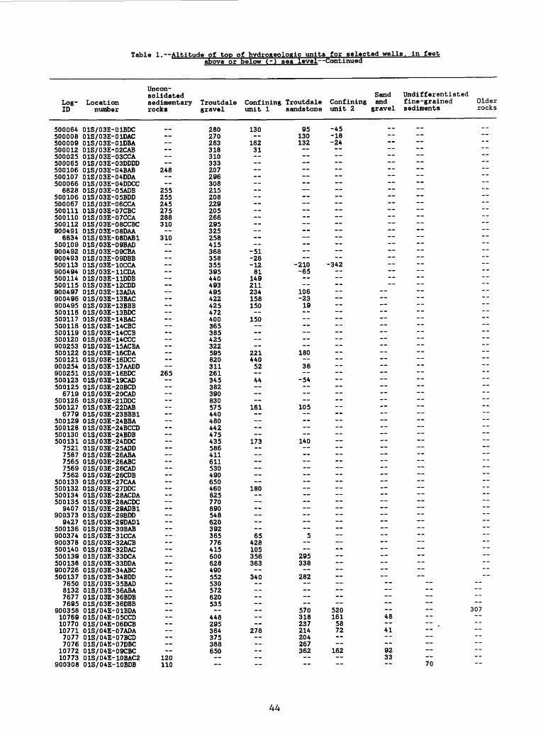
Table 1. Altitude of top of hvdroKeologic units for selected wells, in feetabove or below (-) sea level Continued
Uncon- solidated Sand Undifferentiated
Log- Location sedimentary Troutdale Confining Troutdale Confining and fine-grained Older ID number rocks gravel unit 1 sandstone unit 2 gravel sediments rocks
500064 01S/03E-01BDC500008 01S/03E-01DAC500009 01S/03E-01DBA500012 01S/03E-02CAB500025 01S/03E-03CCA500065 01S/03E-03DDDD500106 01S/03E-04BAB500107 01S/03E-04DDA500066 01S/03E-04DDCC
6628 01S/03E-05ADB500106 01S/03E-05BDD500067 01S/03E-06CCA500111 01S/03E-07CBC500110 01S/03E-07CCA500112 01S/03E-08CCBC900491 01S/03E-08DAA
6634 01S/03E-08DAB1500109 01S/03E-09BAD900492 01S/03E-09CBA900493 01S/03E-09DBB500113 01S/03E-10CCA900494 01S/03E-11CDA500114 01S/03E-11DDB500115 01S/03E-12CDD900497 01S/03E-13ADA900496 01S/03E-13BAC900495 01S/03E-13BBB500116 01S/03E-13BDC500117 01S/03E-14BAC500118 01S/03E-14CBC500119 01S/03E-14CCB500120 01S/03E-14CCC900253 01S/03E-15ACBA500122 01S/03E-16CDA500121 01S/03E-16DCC900254 01S/03E-17AADD900251 01S/03E-16BDC500123 01S/03E-19CAD500125 01S/03E-20BCD
6719 01S/03E-20CAD500126 01S/03E-21DDC500127 01S/03E-22DAB
6779 01S/03E-23BBB1500129 01S/03E-24BBA500128 01S/03E-24BCCD500130 01S/03E-24BDB500131 01S/03E-24DDC
7521 01S/03E-25ADD7587 01S/03E-26ABA7565 01S/03E-26ABC7569 01S/03E-26CAD7562 01S/03E-26CDB
500133 01S/03E-27CAA500132 01S/03E-27DDC500134 01S/03E-28ACDA500135 01S/03E-28ACDC
9407 01S/03E-29ADB1900373 01S/03E-29BDD
9427 01S/03E-29DAD1500136 01S/03E-30BAB900374 01S/03E-31CCA900378 01S/03E-32ACB500140 01S/03E-32DAC500139 01S/03E-33DCA500138 01S/03E-33DDA900726 01S/03E-34ABC500137 01S/03E-34BDD
7650 01S/03E-35BAD8132 01S/03E-36ABA7677 01S/03E-36BDB7695 01S/03E-36DBB
900358 01S/04E-01BDA10769 01S/04E-05CCD10770 01S/04E-06DCB10771 01S/04E-07ADA7077 01S/04E-07BCD7076 01S/04E-07DBC
10772 01S/04E-09CBC10773 01S/04E-10BAC2
900308 01S/04E-10BDB
__
248
255255245275288310
310
265
120110
280270283318310333207296308215208229205266295325258415368358355395440493495422425472400365385425322595820311261345382390830575440480442475435586411611530490650460825770890548620392365776415600628490552530572620535
448295364375388650
130
16231
-51-26-1281
149211234158150
150
22144052 44 161
173 --
180 65
428105356363
340
278
95130132 -- ---- --
-210-65
106-2319
180 36
-54
105
140 5
295338
282
570318237214204267362
-45-18-24
-342 --__ -- -- ____ __ __ -- __ -- --
520161 4858 .72 41
162 9233
70
-- "" "--"--"-~~-"-"-"~~~~~~~~-""" --~~~ "-~~--- "" ""~~~~~~~~~~ *~~~~~ ~-- - ~ ~~~~ "~~~~~~~~" ~"-- - - ~~~~ "" ** ~ --- --
~~ ~*~
307 -- ~~~~ ~~
44

Table 1. Altitude of top of hydroKeologic units for selected wells. in feet
Log- LocationID number
900306 01S/04E-11ACC10774 01S/04E-14CBB10775 01S/04E-14CCC10776 01S/04E-15BAB10777 01S/04E-15CBC10778 01S/04E-16ADB10779 01S/04E-16ADC
900324 01S/04E-17ACB10780 01S/04E-17BAD
900500 01S/04E-17DCB900498 01S/04E-18ACD900325 01S/04E-18ADC1900326 01S/04E-18ADC2900327 01S/04E-18DAA900499 01S/04E-18DAA2900328 01S/04E-18DDC10781 01S/04E-19BBD
900359 01S/04E-19BCBB10782 01S/04E-20BCB
900329 01S/04E-20DAA10783 01S/04E-21DDC
900501 01S/04E-22BAB900330 01S/04E-22BDC
9182 01S/04E-22DCC900331 01S/04E-23CDC\ 7115 01S/04E-26ACB
7091 01S/04E-26BAA7101 01S/04E-26CCB7459 01S/04E-26CCC7135 01S/04E-28ABC7129 01S/04E-28ADA
900309 01S/04E-28ADD17139 01S/04E-28BAC7128 01S/04E-28DDB
900447 01S/04E-29AAA7146 01S/04E-29BDA7143 01S/04E-29CAA7152 01S/04E-29CAA
900444 01S/04E-29DCC7209 01S/04E-30ADB7164 01S/04E-30ADD7192 01S/04E-30BDA7183 01S/04E-30CBB7244 01S/04E-30CCB7236 01S/04E-30DCD
900448 01S/04E-31CBB7239 01S/04E-31CCD7277 01S/04E-32CAD7253 01S/04E-32DAB7312 01S/04E-33DBA7343 01S/04E-33DBA7368 01S/04E-34ABB7356 01S/04E-34CBA7394 01S/04E-34DBD7460 01S/04E-35BAA
900443 01S/04E-35BCB900502 01S/05E-31ACA
5098 02N/01E-01AAD5095 02N/01E-01DAB1
900680 02N/01E-02BAA900679 02N/01E-02CAB900320 02N/01E-02DDCC
5103 02N/01E-03CCB111571 02N/01E-04BAD15105 02N/01E-07BCB5107 02N/01E-07CBB15108 02N/01E-09CAD15109 02N/01E-09DBB15116 02N/01E-10AAD1
900321 02N/01E-10CBCC900381 02N/01E-11AAB1900227 02N/01E-11ABC1900383 02N/01E-11BAB111575 02N/01E-11BAB211574 02N/01E-11BAB3
900382 02N/01E-11BAB411563 02N/01E-11BAB511572 02N/01E-11BAC15118 02N/01E-11CDC15120 02N/01E-12AAA1
Uncon-solidatedsedimentaryrocks
15011214080 ---- -- -- ---- ----
27027320022024321821520203050
195153238258225226227250230230220281
above or
Troutdalegravel
__
648672672573515528495525523549550550533520573612612673653650475537500730746603646660589663560566592585580611615540581601605571535538576625625710675705717740 10990
1001008570
-48-8378
10211479858584
1038581
165
below (-) sea level Continued
Confiningunit 1
__
422330332284285235213255225253202203273332
551 --
446
337
352
381
399
282279
575 --
Troutdalesandstone
__
416469367286207164130164163194142
266450544473443410
467
416
358316--
315
326335
335
294
241249
513568450 -- ---- -- --
SandConfining andunit 2 gravel
__ --91
333 25887
113 41
-16-16__ __ __
220
232__ -- --
220 ---- --
117
124---- -- -- -- 78 48 -- ----
402__ --
502-- -- __ -- --__ -_ --__-- ------__ -- --__-- --
Undifferentiatedfine-grainedsediments
110
12545 ------------------~~---- ------ ---------- --
---------- -------- ------ -- - ---- -------
590 --
-212-230
--- -- - -- ---
-230-- - ---
-359
Olderrocks
20
-205----
-341---------------------- ------ ---- ------
---434
~
"" ~
"~
~~
~~
_-
--
"""
~~
~
~ "~
~~
--
-,
-
~~
~"
""""
_
-
~~
340 - - "* ~~ - - ~~~~~~~~ -~~
45

Table 1. Altitude of too of hydrogeologic units for selected wells, in feet
Log- LocationID number
5119 02N/01E-12DAD15127 02N/01E-13CAC15129 02N/01E-13DB513A 02N/01E-15AAD1
900322 02N/01E-15CDDB900A05 02N/01E-15DCB1900A07 02N/01E-15DCB3
5136 02N/01E-16CAB190068A 02N/01E-18CDD1900689 02N/01E-18CDD2900690 02N/01E-18DCC1900693 02N/01E-18DCC290069A 02N/01E-18DCC3900699 02N/01E-18DCCA900700 02N/01E-18DCC5900701 02N/01E-18DCC5900687 02N/01E-19AAB1900691 02N/01E-19AAB1900697 02N/01E-19AAB2900698 02N/01E-19AAC1900702 02N/01E-19AAC3900703 02N/01E-19AACA90070A 02N/01E-19AAC5900705 02N/01E-19AAC6900695 02N/01E-19ABA1900696 02N/01E-19ABA2900686 02N/01E-19ABC1900685 02N/01E-19ABD1900692 02N/01E-19ABD3900228 02N/01E-21AAB1
5139 02N/01E-21BBC1900528 02N/01E-21CCD1900529 02N/01E-21CCD2
51A2 02N/01E-22ABD151A8 02N/01E-23CBA151A5 02N/01E-23CDC1
11583 02N/01E-23DCA11158A 02N/01E-23DCA2
900323 02N/01E-23DCAD51A7 02N/01E-23DCC151A6 02N/01E-23DCD1
900A08 02N/01E-23DCD1900A09 02N/01E-23DCD2900A10 02N/01E-23DCD3900A11 02N/01E-23DCDA900 A 12 02N/01E-23DCD5900A13 02N/01E-23DDB111585 02N/01E-23DDB211586 02N/01E-23DDB3
900229 02N/01E-2AACD15150 02N/01E-2ADCD15153 02N/01E-25CDA1515A 02N/01E-25CDA25158 02N/01E-26ABB15157 02N/01E-26ABB25156 02N/01E-26BDB15159 02N/01E-26CAC1
90023 A 02N/01E-27ACB1900230 02N/01E-27CBC1900231 02N/01E-27CBC2900232 02N/01E-27CBC3900233 02N/01E-27CDB1
5163 02N/01E-27CDDB900235 02N/01E-28ACA19002A3 02N/01E-28ACA2900238 02N/01E-28ACB1900236 02N/01E-28ACB2900237 02N/01E-28ACB3900239 02N/01E-28ACBA9002AO 02N/01E-28ACB5
5167 02N/01E-28ACB65166 02N/01E-28ACB7516A 02N/01E-28BAA
900375 02N/01E-28BAA15165 02N/01E-28DAAB
9002AA 02N/01E-35BDA19002A5 02N/01E-35BDA29002A6 02N/01E-35BDA3900A15 02N/01E-36ABA1900A1A 02N/01E-36ABA12900A17 02N/01E-36ABA13
Uncon-solidatedsedimentaryrocks
26525526517321821521A25282828313332333328303A3330323230293230303065213333
21021118517718817521021022218718518518217817A17817017513513517519113085
100A2A23535282828282828303028282828A8313131505055
above or below (-) sea level Continued
Sand UndifferentiatedTroutdale Confining Troutdale Confining and fine-grainedgravel unit 1 sandstone unit 2 gravel sediments
__ __ __ -- - 61 15
-117-52-36
-38 9A121137-65-55
-117
-A2-51-A7-A7-A9-A9-A2-82-8775
-11
-AO-A86519
-70-78-67
-106 -- ~ -329
-110 ~ -27A
-92 ~ ~ -307__
-6A
-51
Olderrocks
__ ------------------------------------------------------------------------------------------------------------------------------------------------------------
46

Log- LocationID number
900418 02N/01E-36ABA14900419 02N/01E-36ABA15900416 02N/01E-36ABA6900420 02N/01E-36ABA9
5170 02N/01E-36ADA15169 02N/01E-36ADA25721 02N/01W-07ADD15740 02N/01W-14CAD15773 02N/01W-16BCC15763 02N/01W-17DAD15775 02N/01W-17DDB15826 02N/01W-27CAC15829 02N/01W-27CDC1
900567 02N/01W-35DAC900571 02N/01W-35DDB900568 02N/01W-35DDBB900569 02N/01W-35DDBD900570 02N/01W-35DDCA900572 02N/01W-36BCC1500167 02N/02E-01CAD
3391 02N/02E-02ADC500168 02N/02E-02CBA500169 02N/02E-03CAC500170 02N/02E-04DBB500171 02N/02E-05ADB500172 02N/02E-06BBD
3424 02N/02E-06CDC900426 02N/02E-07AAB1900427 02N/02E-07AAB2500173 02N/02E-07CAA500174 02N/02E-08BAB500175 02N/02E-09DAD900422 02N/02E-10CCB1900423 02N/02E-10CCB2500203 02N/02E-10CCB3500176 02N/02E-11BCDD500177 02N/02E-11BDB500166 02N/02E-12ADC500165 02N/02E-13DDB500199 02N/02E-14DDC1500200 02N/02E-14DDC2900424 02N/02E-14DDC3900425 02N/02E-14DDC4500178 02N/02E-15CCA500179 02N/02E-16CBD500180 02N/02E-17BBB500202 02N/02E-18ACB1900421 02N/02E-18ACB3500181 02N/02E-20AAA500195 02N/02E-20DBB1500196 02N/02E-20DBB2500197 02N/02E-20DBB3500198 02N/02E-20DBB4
3555 02N/02E-21CBC500182 02N/02E-21CBC500183 02N/02E-22BCB500185 02N/02E-23CAA
3588 02N/02E-23CAB500184 02N/02E-23CDC500187 02N/02E-23DCA500186 02N/02E-23DCC500188 02N/02E-24BDB900200 02N/02E-24BDB500189 02N/02E-25BBD500201 02N/02E-27BBC1500191 02N/02E-27BCB900453 02N/02E-27BDA500190 02H/02E-27CAA500192 02N/02E-28BDA500193 02N/02E-29CBDB500194 02N/02E-30CAA900065 02N/02E-30DCC900109 02N/02E-31ADD900110 02N/02E-32CAC900111 02N/02E-33ADB900068 02N/02E-33CDA900112 02N/02E-34ADD900069 02N/02E-34BCAD900115 02N/02E-35CBA900113 02N/02E-35DAB
Uncon-solidatedsedimentaryrocks
50605555393835203030202030304040404445
258270263240230205260269270270300253235220220220218235215
239266266239205200285304302210210208209207185185218231235308311315235235305314315318312305296295295190
304
303302302300
above or below (-) sea level Continued
Sand UndifferentiatedTroutdale Confining Troutdale Confining and fine-grainedgravel unit 1 sandstone unit 2 gravel sediments
__ __ __ __ -- --
-51 -- ~ -198-80.
-96
208 103 99220221
175126
142146140128189180171167188 68155 8321123514318819016411780
125206 -158235167113111115119
155187171157186206167190190
180 -188180184201133146133195132110 -182183180 -187 -319 -372201193209225
Olderrocks
__----------------------
-166--------------------------------------------------------
----------------------------------------------- --------- -~~--------~~--~~ *~
47
Table 1. Altitude of top of hvdrogeologic units for selected wells, in feet
Log- LocationID number
900114 02N/02E-36DDB5568 02N/02W-13ACC1
500104 02N/03E-03BBA500103 02N/03E-04AAC500068 02N/03E-04ABCD500102 02N/03E-04BBA500101 02N/03E-05CDB500100 02N/03E-06CBB500099 02N/03E-06DDB500098 02N/03E-07DAB500097 02N/03E-08CAB500096 02N/03E-09CDD500095 02N/03E-09DCA500094 02N/03E-10DBB500093 02N/03E-11DCB1500092 02N/03E-12CDC500091 02N/03E-13BBC500090 02N/03E-14CCC500089 02N/03E-15CDD500088 02N/03E-16BBC500087 02N/03E-17ABA500086 02N/03E-18ABA500085 02N/03E-19ADC500164 02N/03E-19CCA500084 02N/03E-20DDD500069 02N/03E-21CBD900475 02N/03E-21DCA500083 02N/03E-21DDB500071 02N/03E-22BAC500072 02N/03E-23ABD500074 02N/03E-23CAD500075 02N/03E-24DBC500076 02N/03E-25ABB500077 02N/03E-26BBC500078 02N/03E-27AAC500057 02N/03E-27CDB500056 02N/03E-28DCC500079 02N/03E-29CDA500080 02N/03E-29DBC500081 02N/03E-30ACB500082 02N/03E-30DBA500055 02N/03E-30DCC500054 02N/03E-30DCD500053 02N/03E-31AAB500052 02N/03E-31ADD500051 02N/03E-31DBA500050 02N/03E-31DBD500049 02N/03E-32CAA500048 02N/03E-33DAC500047 02N/03E-34CCA500046 02N/03E-35AAA500045 02N/03E-36ABC
6551 02N/04E-26DBA6550 02N/04E-26DDB6552 02N/04E-27CCA6553 02N/04E-28DCD6554 02N/04E-29BBB
900189 02N/04E-29BBD6555 02N/04E-30ADC6556 02N/04E-31ACB6557 02N/04E-32BBA
900188 02N/04E-32BBC6558 02N/04E-32BCA6559 02N/04E-32DAA6560 02N/04E-33AAA6561 02N/04E-33AAC6562 02N/04E-33CAC6563 02N/04E-34BDC
900201 02N/04E-35DDB6565 02N/04E-36ADC6566 02N/04E-36CCA16567 02N/04E-36CCA2
500302 02S/01E-01BCD500304 02S/01E-02DBB
7836 02S/01E-11AABC500305 02S/01E-12DDA500306 02S/01E-13ABD500307 02S/01E-13DDB500308 02S/01E-14DCAA500309 02S/01E-24CDC500273 02S/02E-01ADA
Uncon-solidatedsedimentaryrocks
277
283245275232289
350
341319202225292189
257248287235287285282277277275255 --
230182
140
300 7255
175257
above or
Troutdalegravel
237
465385310407256226236200257346336
379475283224181
189168
260286495502512665430422420
265232209192204179150194158199140
355390410438
715
370362515703708550725
1030
10401050200
175
348
below (-) sea level Continued
Confiningunit 1
_
150
152 --
1044867 92 --
197 ---- ----
288 -- 58
SandTroutdale Confining andsandstone unit 2 gravel
__ -- --
135
184198 -4570 __ 264 189156977487 7048 -100 44 65
230
231276
__ __
Undifferentiatedfine-grainedsediments
__--
329278 ------ -- -- -- ----
629 -- -- -- ---- -------- 119300294287420
487----------------------
Olderrocks
__32017592------------------
A23790958910------------------10--------
315295----7
------ --------
----------
3AO124156522678635A8320
217219222385--
A66------60----159110165180558
160237
48

Table 1. Altitude of too
Log-ID
5002745002755002775002765002785002795003175002805002925002815002825002835002845002855002865002871152611527
500288500289500290500291500293500294500295500296500297500298500299500300900479900474
8142900370500147
8201500141500148500142500149900376500150500151500145500143500144
8278500152500155500153500154
83398311
900446900445
83328340
90043183699100
114528297
90050311453
50015650015750015890047890037750015950016050016111454
5001625001631145611459
90053211464114658555
Locationnumber
02S/02E-02DBC102S/02E-02DBC202S/02E-03DBC02S/02E-03DDD02S/02E-04DCC02S/02E-05CBD02S/02E-06ABDA02S/02E-07DDD02S/02E-08ABAD02S/02E-08CCC02S/02E-09CCB02S/02E-10BDD02S/02E-11DAA02S/02E-11DDB02S/02E-12ADA02S/02E-13ABA02S/02E-13DAC02S/02E-14ADD02S/02E-14BAA02S/02E-15ADC02S/02E-15BBB02S/02E-16BBB02S/02E-16BDDB02S/02E-17BDA02S/02E-17CBBB02S/02E-18ACB02S/02E-18BDA02S/02E-19ACB02S/02E-19DAC02S/02E-20BBD02S/02E-30BDD02S/03E-01CCC02S/03E-01DCA02S/03E-03DCC02S/03E-04ADB02S/03E-05CBC102S/03E-05DDBC02S/03E-06BDB02S/03E-06BDD02S/03E-07BAC02S/03E-07BDDA02S/03E-08BAD02S/03E-08DCB02S/03E-09AAB02S/03E-09ACA102S/03E-09ACA202S/03E-09CDC02S/03E-09CDD02S/03E-10AAA02S/03E-10BAC02S/03E-10BAC02S/03E-11AAD02S/03E-11ACC02S/03E-11ACC02S/03E-11BDA02S/03E-12CDC02S/03E-12DBD02S/03E-13AAC02S/03E-13ABC02S/03E-13ADC02S/03E-13CDC02S/03E-14BCC02S/03E-14CBC02S/03E-14CDC02S/03E-15CAD02S/03E-15CCD02S/03E-16ABB02S/03E-16BDC02S/03E-17ABA02S/03E-17ACD02S/03E-17BAD02S/03E-18CBC02S/03E-18CDD02S/03E-20BAC02S/03E-21BBC02S/03E-23AAC02S/03E-23BDB02S/03E-24AAA02S/03E-24BCB02S/03E-24DBC02S/04E-01CBA1
Uncon-solidatedsedimentaryrocks
__ 95
100125
151
135122148132
15811575
. 12565
104112118 98558895
285
190260248182 175120
265250
257295
above or
Troutdalegravel
355352380312457159 1
2653977
338 548981
320211 32
597551615762590548333362418407528422590522522628640575618618565565542541580613601586
490
655642365250312115
172
585
of hydroxeologic unitsbelow (-)
Confiningunit 1
12170
-33 106
522
515 61
272
485498498
465 --
for selected wells . in feetsea level Continued
Troutdalesandstone
_4
-196 3
427436425
245 2
257419402416
447413413475470364469404493509528
470
590
SandConfining andunit 2 gravel
-i. --
-2-220
-57 9938
301
375380
196
-18
356317314
405321321
386417409--
290
395
Undifferentiatedfine-grainedsediments
__
-135
-10310965
118 7834-9--
-52-- 56 ------------
205
328319------
-- -- -- --
382280--
181222229170
25627018727761
15155
112244222
259541
Olderrocks
__----------
-354306 222---------------- --------
307138154132-15-316774----------
-285-------------9
-10
1271
----------------------------
-380----
-238----75--4
------------------
132
49

Table 1. Altitude of top
Log- LocationID number
8577 02S/OAE-02BAD8687 02S/OAE-02BDB8686 02S/OAE-02CDA1
300978 02S/OAE-02CDD1868A 02S/OAE-02CDD28631 02S/OAE-03ACB86AO 02S/OAE-03DCD865A 02S/OAE-OAACB
900316 02S/OAE-OABDD900A32 02S/OAE-OADBD301669 02S/OAE-OADCC1900A33 02S/OAE-OADDA
8683 02S/OAE-OADDD900A3A 02S/OAE-05CBB
87AA 02S/OAE-05CCC8709 02S/OAE-05DAA8710 02S/OAE-05DAB
900AA2 02S/04E-05DDA87A2 02S/OAE-06ABB8767 02S/OAE-06ACB8777 02S/OAE-06CCD8775 02S/OAE-06CDD8787 02S/OAE-07ABA8806 02S/OAE-07ACA8782 02S/OAE-07BAA8791 02S/OAE-07BAA8799 02S/04E-07BAA
900A28 02S/OAE-07BAA8789 02S/OAE-07BAD8785 02S/OAE-07CAB8350 02S/OAE-07CBA8330 02S/OAE-07CBC878A 02S/OAE-07DBA
900A35 02S/OAE-07DCB8825 02S/OAE-08ABB8815 02S/04E-08ADC
900A39 02S/OAE-08BAA8810 02S/04E-08BAC8830 02S/OAE-08BDD8816 02S/OAE-08DAA8856 02S/04E-09ABB8846 02S/OAE-09BBB885A /02S/OAE-09CAA8837/02S/OAE-09DAA88A7 02S/OAE-09DCB8913 02S/OAE-10ADD8882 02S/OAE-10BBB88,69 02S/OAE-10BBD8836 02S/OAE-10BCB888A 02S/OAE-10BDB8/933 02S/OAE-11ACB^929 02S/OAE-11BBB89A2 02S/OAE-11CCC
900360 02S/OAE-13BDDD8998 02S/OAE-15CBD11A72 02S/OAE-15DAD9062 02S/OAE-16BDB
11A7A 02S/OAE-16DAD90A8 02S/OAE-16DDA9075 02S/OAE-17BAC9071 02S/OAE-17CBB9097 02S/OAE-17CBC
900AAO 02S/OAE-17CCB11A78 02S/OAE-18ACC9090 02S/OAE-18ACD9093 02S/OAE-18ADD8797 02S/OAE-18BAC11A79 02S/OAE-19ACD11A80 02S/OAE-19CCC9130 02S/04E-20ACB
11A81 02S/OAE-20ADB9166 02S/OAE-21BCD9133 02S/OAE-21CCA9006 02S/OAE-22ABC11A82 02S/OAE-22BBD
900AA1 02S/04E-22CBC9183 02S/04E-22DAD11A85 02S/OAE-23AAD8996 02S/OAE-23BBC9222 02S/04E-23BCC9270 02S/OAE-2ACBB
above or
Uncon-solidatedsedimentary Troutdalerocks gravel
78177983082581A7167556A262567365569269A5A15635915915995A553059A57559862 A60860860060861168A6A16A2600
5926605785916AO6A5665622650702
7006926766938A1791810981696770675
792
700692
6A5611665
--635
305
710700
--810
937960901896
1023
of hydrogeoloftic unitsbelow (-)
Confiningunit 1
_ 591512516
578618A61A10
3A9
A58A20
A85A90A90A70
536
51A
A54A25A28AA1535508562A77
5955357786A3609
65569170969582667373859A765691 --
669869720
817862727
830
for selected wells . in feetsea level Continued
Troutdalesandstone
576589618559599501561A27385
555A6AA 69382365
32A
A29380
A57AllAll39A350A 16
A135AOA18A85387385368386A85
A70A 17A79505AA15835AO532502501
56A598621631676535675616586651
7005655AA605
615
6A87807006626756668117A7
7007A6723
Sand UndifferentiatedConfining and fine-grainedunit 2 gravel sediments
_A1953A A65A39A7A__
298
233
__
A07369AID
263
325 -- -- --
- 556
598AA5 700
578682
AAO555
375
609650552607539
64A727
631
Olderrocks
------------------------------------------ ------------------------------------------ ----------
------------
270----23------------------
-74-- ------
50

Table 1. Altitude of too
Log- LocationID number
9280 02S/04E-24DAA11491 02S/04E-24DBA9213 02S/04E-25ABA11492 02S/04E-25BDC
900598 02S/04E-26ACD900599 02S/04E-26BBC11494 02S/04E-26BCD10452 02S/04E-26DAB11496 02S/04E-27BAB11497 02S/04E-27BDA
900601 02S/04E-28BDB11500 02S/04E-28CDA11502 02S/04E-29DAA
900364 02S/04E-29DAD11503 02S/04E-29DDA11504 02S/04E-30BAA11507 02S/04E-30CBD
900674 02S/04E-30DCB11517 02S/04E-32BAB11519 02S/04E-32DAB11520 02S/04E-33BCD11522 02S/04E-34BCC
900600 02S/04E-34DAD900602 02S/04E-34DBA11523 02S/04E-36DCA
900603 02S/04E-36DCA900037 03N/01E-01DAC900038 03N/01E-02CCB900040 03N/01E-03ABB900039 03N/01E-03CBD900041 03N/01E-04AAA900042 03N/01E-04CAA900043 03N/01E-05ACD900044 03N/01E-06ADA900047 03N/01E-07ADB900046 03N/01E-07BBC900048 03N/01E-08CBA
6526 03N/01E-08DCB16527 03N/01E-08DCB26528 03N/01E-09CBD
900070 03N/01E-10BAC6529 03N/01E-10CAD6530 03N/01E-11BBA
900071 03N/01E-12DCD6531 03N/01E-13DB6532 03N/01E-13DBC6533 03N/01E-14CAC6534 03N/01E-15CBD6535 03N/01E-16BAD6536 03N/01E-17BAD6537 03N/01E-17CA6538 03N/01E-17CDD6539 03N/01E-18DBC
900073 03N/01E-18DDB900074 03N/01E-20BAD
6541 03N/01E-20CDD11564 03N/01E-21CDA16542 03N/01E-21CDC6543 03N/01E-22BBB
900075 03N/01E-23CBD900076 03N/01E-23DCA900077 03N/01E-24CAA900078 03N/01E-24DBB
6544 03N/01E-25ACB6545 03N/01E-26BAC6548 03N/01E-27BCB
900379 03N/01E-27CDA1900380 03N/01E-27DDD1
6549 03N/01E-28AAB11566 03N/01E-28CCD1
900455 03N/01E-28CCD2900128 03N/01E-29ADD900313 03N/01E-30CCD900129 03N/01E-30DAD900130 03N/01E-32DAB900131 03N/01E-33ACB
3957 03N/01E-33BCB11568 03N/01E-33DCC1
900132 03N/01E-34CCD11573 03N/01E-34DDD111570 03N/01E-35ABA1
Uncon-solidatedsedimentaryrocks
__
310320325
262235215300
24221522095
179172171232
270272213213280201196151179174127148173190180125191206
1471272192011712540
17121521520510
135199213210215197210110
above or
Troutdalegravel
1078107510951105107092010151030905920645772725712685
420432
802
8621200120218714213623337136011787
1021092596311230332120819717315621211212658598237486748676386
119302--
12212612091
-41-547857870
-195428772 77
12910032
of hvdroReologic unitsbelow (-)
Confiningunit 1
_951
1041836
994855 63 --
sea level
Troutdalesandstone
942870
934775
887705
721650640661 --
for selected wellsContinued
SandConfining andunit 2 gravel
_ _
849725
863645675
663563564 ____ ____ -- --
. in feet
Undifferentiatedfine-grainedsediments
__ --
885-- --
605
275
277352
535
779763
11211111 73
199183-30
-127-79 101-- 88
123 4
----
-128
160127101 ----
-219--
-340 -- -- --
-56
Olderrocks
------ -- ------
105----------------------
394512--
672---- --------------------------------------------------------------
-------------------------- ------------
51

Log- LocationID number
11561 03N/01E-35ABA211562 03N/01E-35ABA33282 03N/01E-36AAD111565 03N/01E-36AAD1
900133 03N/01E-36ABD6521 03N/01W-01ADD
900045 03N/01W-01DAA9613 03N/01W-06BAA16522 03N/01W-25BDC6523 03N/01W-25DBA6524 03N/01W-25DCB6525 03N/01W-36ADA2708 03N/02E-01BAB
900134 03N/02E-02BBB900333 03N/02E-03AADD900389 03N/02E-03ABA1900388 03N/02E-03ABA211594 03N/02E-03DBA111593 03N/02E-03DBA22719 03N/02E-04ABD2722 03N/02E-05BCC
900135 03N/02E-05CCB2734 03N/02E-06AAD
900157 03N/02E-06CBB900136 03N/02E-07ACB900158 03N/02E-07DBC900137 03N/02E-07DCB900138 03N/02E-08AAC900139 03N/02E-08BBB2745 03N/02E-08BCA
900140 03N/02E-08CBC900141 03N/02E-09ADD1900142 03N/02E-09ADD22754 03N/02E-09CAD2766 03N/02E-10DDB2771 03N/02E-11BCD2773 03N/02E-12DBB2780 03N/02E-13ACB2814 03N/02E-14CBC2830 03N/02E-15DAC2832 03N/02E-15DAD2841 03N/02E-16BBC
900143 03N/02E-17DCC2847 03N/02E-17DDC2881 03N/02E-18BAA
900144 03N/02E-18BBB2905 03N/02E-19BBA2926 03N/02E-20ADA
900145 03N/02E-21AAB900146 03N/02E-21AAC900147 03N/02E-21DAB2965 03N/02E-22AAD
900148 03N/02E-23ABB900149 03N/02E-23ADA11577 03N/02E-23BAB111576 03N/02E-23BAB2
900150 03N/02E-23BBA2997 03N/02E-23CAB2989 03N/02E-23CBC
900151 03N/02E-23DAD900152 03N/02E-24CDC900219 03N/02E-25CAC
3005 03N/02E-25CBD3017 03N/02E-26CDC3022 03N/02E-26DDD
900153 03N/02E-27BDB900154 03N/02E-27BDC
3030 03N/02E-27CCO900319 03N/02E-28AAB
3064 03N/02E-28ADD900220 03N/02E-28BAB
3083 03N/02E-29DBD3111 03N/02E-30AAA
900221 03N/02E-30BAB900155 03N/02E-30BBD
3094 03N/02E-30CDA11569 03N/02E-31CBC13141 03N/02E-31DBB3166 03N/02E-32BDC3188 03N/02E-33BAB
Uncon-solidatedsedimentaryrocks
1101102502502441441324218132111
292287290290280280269223215212264193200200275225230230282283280273281258203291276283273245261209220214256258264290295285295280280290293298295280275275283280287295283285288278195198232231240252268220215
above or
Troutdalegravel
29379797
126195
-239
345280277258223232246226187200185234185171171200200190165202203204199243200193202195207200177188170177159211158181187217212194195212212202199190200169188183214224199166
147155
144142138115154156120
below (-) sea level Continued
Confiningunit 1
__
-24-24 68101101
158
125
122102112
105
103 93
145
134125103
Ill33
-65
-45
Troutdalesandstone
__
-35 32 ,
112 5988 3638-7
-330
Confiningunit 2
_
-56 12
-15 -7
-32
-431
Sandand
gravel
__ 37
Undifferentiatedfine-grainedsediments
-53
-41
-243
132162148146140144
11093
106
108
123 99 -- --
127
Olderrocks
-- -- -- ----
324---------------------------------------- ---- ------ ------------------------------------------------
------------ --
52

Table 1. Altitude of top of hydroseoloKic units for selected wells, in feetabove or below (-) sea level Continued
Log- LocationID number
3203 03N/02E-34CBA900222 03N/02E-35ADA11580 03N/02E-35BBB3238 03N/02E-35DDD3283 03N/02E-36BAD
90015$ 03N/02E-36BCA3685 03N/02E-36CAD
900578 03N/02W-12DA9799 03N/02W-12DCB19796 03N/02W-13ABD19811 03N/02W-13CAC19924 03N/02W-24CCB19934 03N/02W-24CDA111582 03N/03E-03CDC2091 03N/03E-04ADA
900604 03N/03E-05BDD2127 03N/03E-06CDB2165 03N/03E-07CAA2191 03N/03E-08BDB2296 03N/03E-08DCC2301 03N/03E-17AAB2298 03N/03E-17DAD2309 03N/03E-18AAD2303 03N/03E-18ABC2323 03N/03E-19DCD2368 03N/03E-20ABD
900566 03N/03E-20BAA2386 03N/03E-21DAB12385 03N/03E-21DAB2
900384 03N/03E-28BBB12585 03N/03E-30BAB2584 03N/03E-30BCC2586 03N/03E-31CBB
500105 03N/03E-34DDD900612 03S/04E-01CBD900613 03S/04E-02BBC900614 03S/04E-02DCB900615 03S/04E-02DDC900616 03S/04E-03ACA1900617 03S/04E-03BAD1900618 03S/04E-03BDD900621 03S/04E-04ADB900620 03S/04E-04BBC900619 03S/04E-04DAA900622 03S/04E-05ABC900623 03S/04E-05BDC900625 03S/04E-05CAC900624 03S/04E-05CAC2900626 03S/04E-06BCC900627 03S/04E-06DBA900628 03S/04E-07CDC900629 03S/04E-08AAB900630 03S/04E-09CAB900631 03S/04E-10CCB900632 03S/04E-10CDB900633 03S/04E-11ACB900634 03S/04E-12AAC900635 03S/04E-12BCB900636 03S/04E-13CCD900637 03S/04E-14CAC900638 03S/04E-15ACC900639 03S/04E-15ADD900640 03S/04E-15BAD900641 03S/04E-15BCB1900642 03S/04E-16CBC900643 03S/04E-17ACC900644 03S/04E-18BBA900645 03S/04E-19BDD900646 03S/04E-21ADC900647 03S/04E-22BDA900648 03S/04E-23ABC900649 03S/04E-23BBD900650 03S/04E-23BCC900651 03S/04E-23DCA900652 03S/04E-25BBB900653 03S/04E-25BDC1900654 03S/04E-25BDC2900655 03S/04E-26ABD900656 03S/04E-26CDA900657 03S/04E-27ADD900658 03S/04E-27CDB
Uncon-solidatedsedimentaryrocks
26927128027926826927036623070
25085
281262266
380385385355362390
382305
Troutdale Confining Troutdalegravel unit 1 sandstone
131 77188212 87 19184199204 123 103 32171647 60
530368322400535415510483353337480511
491256219204
1165104010901100930815865510465
445
450670832810
1235
960890880887850490462
755880
109510701115109011101100115011201020900
Confiningunit 2
_
-17
--
323333342
295
418650
724
817854813790
337277730
9851025
1060976
Sandand
gravel
__ -- -- -- ---- ------------ -- ---- -- --
Undifferentiatedfine-grainedsediments
_
235
489323260376387367410
397397
106
909
946
743
510384
1147930 ----------
Olderrocks
__--------------------62--
420442106150113223--
202355319----
305--
830830416------
341----------------------21----------------
650565--
759635908--
709712----------
685--
--891--
1046--
10721057
------
816
53
Table 1. Altitude of top of hydrogeolosic units for selected wells. in feetabove or below (-) sea level Continued
Log- LocationID number
900659 03S/04E-28ADD900660 03S/04E-26BDD900661 03S/04E-29CCA3900662 03S/04E-29DAB900663 03S/OAE-29DBD900664 03S/04E-30BCA900665 03S/04E-30CAA900666 03S/04E-32ACD900667 03S/04E-32BAA900668 03S/04E-32CBB900669 03S/04E-33CDB900670 03S/OAE-3AADA900671 03S/OAE-3AADD900672 03S/04E-35DBC900673 03S/04E-36DDB
794 04N/01E-01BAD802 OAN/01E-02BCA806 04N/01E-03CDC812 04N/01E-04BAC1819 04N/01E-05ACC823 OAN/01E-06ABD841 04N/01E-07ADD832 04N/01E-07CBC846 04N/01E-08CBA854 04N/01E-09BCA866 04N/01E-10BCB869 04N/01E-11CCC883 04N/01E-12DBB897 04N/01E-13ABA906 04N/01E-14BDC916 04N/01E-15ADD919 04N/01E-16CCD931 04N/01E-17ACC939 OAN/01E-18DAD959 04N/01E-19ADDC952 04N/01E-19BDA1950 OAN/01E-19BDA2960 OAN/01E-19BDB2
900398 OAN/01E-19BDB3951 04N/01E-19BDB4974 OAN/01E-20AAA979 04N/01E-21DBA1
900476 04N/01E-21DBC985 04N/01E-22ACD988 04N/01E-22DDD996 04N/01E-23CDC
1005 04N/01E-24CCD1035 04N/01E-25CAC1053 04N/01E-26BCB
900438 04N/01E-26CBC987 04N/01E-27ABB1064 04N/01E-27BBC1063 04N/01E-27DAD1069 04N/01E-28DAA1092 04N/01E-29CDA1096 OAN/01E-30DDB1100 04N/01E-31DAA1104 04N/01E-32CBB1107 04N/01E-33ABC1124 04N/01E-34AAA1138 04N/01E-35AAD1145 04N/01E-36ABA
900580 OAN/01W-05DDB19991 OAN/01W-07BCBB9990 04N/01W-07CCA19989 04N/01W-07CCA2
900399 04N/01W-13DCA1900582 04N/01W-17BDD1900581 04N/01W-17CAA1900579 04N/01W-19CBC1
269 04N/01W-24ABA1270 04N/01W-24ABA21157 04N/02E-01DBD1165 04N/02E-02AAAD1166 04N/02E-03BDA1167 04N/02E-04BBB11177 04N/02E-05CCC1222 04N/02E-06DBCD1234 04N/02E-07CDA
900223 OAN/02E-07DBC
Uncon-solidatedsedimentaryrocks
_
139145120248130247
2422632792872001652982802522612501054040353540
213260270273257267246261262263268265280225280246248263229250272233
2531601604028251185555
Troutdalegravel
813720
535
85588510459909921105116011651180
3501147075
19369
200175141191214221192141197207182185216703619262538
124198184182188179152179168181160187181166178168166175179175255209 158 38 1623
580561495502258258
Confining Troutdale Confiningunit 1 sandstone unit 2
__ -- --
750448690807852860880
1110 __ __ __ ____
Sandand
gravel
__ ---- -- ------ -- -- --
Undifferentiatedfine-grainedsediments
__
----
2508237
11739751217451149142158115801081271223315-4
-74-54-31-54--89104428856499
101 Ill4953 93 43 -- --
374387143106
Olderrocks
__710712--
515--
574----------
107511341230
------63--------------------------
--10
-200--
-195--
-300----
-457 ------------------------------------
1051136969--1
-22------
682498 ----
54

Table 1. Altitude of top of hydrogeologic units for selected wells, in feet
Log- LocationID number
1239 04N/02E-08CBB1254 04N/02E-09CAC
900482 04N/02E-10ABC1271 04N/02E-10CCB1272 04N/02E-11ACC1280 04N/02E-12DDC1296 04N/02E-13ADB1304 04N/02E-14BAD1312 04N/02E-14DCD1329 04N/02E-15CDC1330 04N/02E-16DAA1341 04N/02E-17CAD1365 04N/02E-18DCA1390 04N/02E-19DCB1421 04N/02E-20CBD1453 04N/02E-21AAA1489 04N/02E-22CAD1516 04N/02E-23ABA
11581 04N/02E-23DBA1538 04N/02E-24BBD1564 04N/02E-25CBA1613 04N/02E-26CBD1681 04N/02E-27AAD1697 04N/02E-28CCC1708 04N/02E-29AAD1727 04N/02E-30CDA1784 04N/02E-31CBB1795 04N/02E-32BBA
900362 04N/02E-32DDCC1807 04N/02E-33DCC1811 04N/02E-35BAD1832 04N/02E-36DDC
10177 04N/02W-12DCC110191 04N/02W-13BDC10301 04N/02W-24ABB110419 04N/02W-36DAB11855 04N/03E-02BBC1
900012 04N/03E-02BBD1900401 04N/03E-02BBD2
1917 04N/03E-17BBC11578 04N/03E-28DDB111579 04N/03E-28DDB21989 04N/03E-29CAC1981 04N/03E-29CCB2001 04N/03E-32BBD
2 05N/01E-08DCA110 05N/01E-08DCA
900126 05N/01E-09ADC10 05N/01E-09CDB12 05N/01E-10BDC19 05N/01E-11DAB16 05N/01E-11DCD28 05N/01E-13CCA31 05N/01E-14CDD36 05N/01E-15BCB33 05N/01E-15CCC45 05N/01E-16DAC47 05N/01E-16DDA52 05N/01E-17BCD156 05N/01E-18DCD63 05N/01E-19DBC77 05N/01E-20AAD92 05N/01E-21ADC88 05N/01E-21CBB109 05N/01E-22ACC96 05N/01E-22DCA
117 05N/01E-23CDD131 05N/01E-24AAB127 05N/01E-24DBC136 05N/01E-25CCB1134 05N/01E-25CCB2161 05N/01E-26BCA170 05N/01E-27ABB175 05N/01E-27DCD275 05N/01E-28BDA280 05N/01E-29ADA281 05N/01E-30ACD
900000 05N/01E-31DCD292 05N/01E-32ABB291 05N/01E-32CAD309 05N/01E-33BDD
Uncon-solidatedsedimentaryrocks
290
340265200 69
270100201230232260319319
24013540
680680700 4545514356
185222 92 --
120123 13
above or below (-) sea level Continued
SandTroutdale Confining Troutdale Confining andgravel unit 1 sandstone unit 2 gravel
268423720525385
305420365322156178195
318227442442505455352395247
168189187236296313484360 71 -25
373
561623
-142 52
623
495588
250
661
673460663799743638615632480595516635
496
253
Undifferentiatedfine-grainedsediments
236379511452295 --
2432002392351291408044
176195195295366323--
22116360
13311972
114186273453 -- --
--------
545556586--------------
602330--
551403505--
208 --
608
515420--------
469--
456----
545----
344--
.
Olderrocks
__--------
676485
-248--------------------------------------------
-129176273--
-92--
678564
--325635662--------------------
563------
243142
4180150860571805----------------
210--
46240558--
240-120154
55
Log- LocationID number
304 05N/01E-33CAA900361 05N/01E-33CABB
807 05N/01E-33CDA327 05N/01E-34ABA
900400 05N/01E-34ACD1325 05N/01E-34ACD2318 05N/01E-34ACD3335 05N/01E-35DBC343 05N/01E-36DCD372 05N/02E-08ABA377 05N/02E-09DAA411 05N/02E-15DBA564 05N/02E-19ABA594 05N/02E-21DDB626 05N/02E-23CCA691 05N/02E-27CDD716 05N/02E-30BCB763 05N/02E-34ACC764 05N/02E-34ACC
900481 05N/03E-12CDD450 05N/03E-1ABCA456 05N/03E-15ABB451 05N/03E-15ABD452 05N/03E-15CAA453 05N/03E-15DBA472 05N/03E-16CDB470 05N/03E-16CDC510 05N/03E-21CAD511 05N/03E-21CCD547 05N/03E-27CCB196 05N/03E-28ABB
900436 05N/03E-35CCA1900402 05N/03E-35CCB1900403 05N/03E-35CCB2
260 05N/04E-07ACA900527 05N/04E-07CBC
262 06N/03E-34ADD267 06N/03E-35BBB
Uncon-solidatedsedimentaryrocks
_165168
293
497450435439428430437407
710
558530
above or below (-) sea level Continued
SandTroutdale Confining Troutdale Confining andgravel unit 1 sandstone unit 2 gravel
250 136575
410275541183435741 581
835
735690712712 __
510625838620
710713
Undifferentiatedfine-grainedsediments
184
126
400410392207493
821
657543679679
Olderrocks
1A712521
404--
160131--
162307--
721809820
628628 ----------
414382494560763542
621637
3131155400
56