a detailed seismic zonation model for shallow earthquakes ... · for this reason, all available...
TRANSCRIPT

Nat Hazards Earth Syst Sci 16 55ndash84 2016
wwwnat-hazards-earth-syst-scinet16552016
doi105194nhess-16-55-2016
copy Author(s) 2016 CC Attribution 30 License
A detailed seismic zonation model for shallow earthquakes in the
broader Aegean area
D A Vamvakaris1 C B Papazachos1 Ch A Papaioannou2 E M Scordilis1 and G F Karakaisis1
1Geophysical Laboratory School of Geology Aristotle University of Thessaloniki 54124 Thessaloniki Greece2Institute of Engineering Seismology and Earthquake Engineering (ITSAK) PO Box 53 55102 Thessaloniki Greece
Correspondence to D A Vamvakaris (domgeoauthgr) C B Papazachos (kpapazageoauthgr)
Received 30 August 2013 ndash Published in Nat Hazards Earth Syst Sci Discuss 25 November 2013
Revised 29 August 2015 ndash Accepted 6 December 2015 ndash Published 18 January 2016
Abstract In the present work we propose a new seismic
zonation model of area type sources for the broader Aegean
area which can be readily used for seismic hazard assess-
ment The definition of this model is based not only on seis-
micity information but incorporates all available seismotec-
tonic and neotectonic information for the study area in an at-
tempt to define zones which show not only a rather homoge-
neous seismicity release but also exhibit similar active fault-
ing characteristics For this reason all available seismologi-
cal information such as fault plane solutions and the corre-
sponding kinematic axes have been incorporated in the anal-
ysis as well as information about active tectonics such as
seismic and active faults Moreover various morphotectonic
features (eg relief coastline) were also considered Finally
a revised seismic catalogue is employed and earthquake epi-
centres since historical times (550 BCndash2008) are employed
in order to define areas of common seismotectonic charac-
teristics that could constitute a discrete seismic zone A new
revised model of 113 earthquake seismic zones of shallow
earthquakes for the broader Aegean area is finally proposed
Using the proposed zonation model a detailed study is per-
formed for the catalogue completeness for the recent instru-
mental period
Using the defined completeness information seismicity
parameters (such as GndashR values) for the 113 new seismic
zones have been calculated and their spatial distribution was
also examined The spatial variation of the obtained b values
shows an excellent correlation with the geotectonic setting
in the area in good agreement with previous studies More-
over a quantitative estimation of seismicity is performed in
terms of the mean return period Tm of large (M ge 60) earth-
quakes as well as the most frequent maximum magnitude
Mt for a typical time period (T = 50 yr) revealing signif-
icant spatial variations of seismicity levels within the study
area The new proposed seismic zonation model and its pa-
rameters can be readily employed for seismic hazard assess-
ment for the broader Aegean area
1 Introduction
Even before the first steps of modern Seismology the reli-
able assessment of seismic hazard was traditionally consid-
ered as one of the most important tasks of Seismology Espe-
cially since the pioneering work of Cornell (1968) it was ob-
vious that this assessment depends on several factors among
which perhaps the most important and often more poorly un-
derstood is the seismic source model The compilation of a
reliable seismic source model requires the use of high qual-
ity (and density) data from various disciplines such as Geol-
ogy (for the location and configuration of potentially active
faults) Geophysics and Geodesy (for the definition of seis-
mic sources not readily observed at the Earthrsquos surface) Ac-
tive Tectonics (for the rate and type of deformation) and His-
torical Seismology (for the elaboration of historical records
of strong past earthquakes)
Modern studies on probabilistic seismicity and seismic
hazard assessment at any scale are usually based on sev-
eral procedures and algorithms which typically require the
study area to be divided into seismogenic source zones In
several cases this corresponds to the definition of a set of
sources (eg sets of polygons for areal seismic sources)
over the seismically active region which is examined In
the case of areal sources the polygons that are often em-
Published by Copernicus Publications on behalf of the European Geosciences Union
56 D A Vamvakaris et al A detailed seismic zonation model for shallow earthquakes in the broader Aegean area
36
FIGURES 909 910 Figure 1 911 912
913
Figure 1 Main seismotectonic features of the study area (broader
Aegean Sea region) Local stress field is depicted by open arrows
while the southern Aegean Benioff zone isodepths (white solid
lines) the southern Aegean volcanic arc and major basins within
the Aegean Sea are also presented (modified from Papazachos et
al 1998 Karagianni et al 2005 Mountrakis et al 2012)
ployed may have a complex geometry reflecting the com-
plexity of major tectonic trends and typically encompass ar-
eas within which seismicity may be considered rather ho-
mogeneously distributed in space and stationary in time In
most cases the geometrical definition of the seismic sources
is followed by the estimationadoption of a statistical model
for the magnitude distribution of the earthquakes within
each source which is parametrized usually by a Gutenbergndash
Richter type frequencyndashmagnitude relation (Gutenberg and
Richter 1944)
Published studies on the compilation and adoption of
proper seismic sources model include various types of
sources such as point sources (eg catalogues of earth-
quakes) linear sources (eg faults) or areal type of sources
(polygon-type active regions with known tectonic and seis-
mic activity parameters) In several cases seismic zonation
models have been used for seismicity or earthquake forecast-
ing studies A first global zonation attempt was performed by
Flinn and Engdahl (1965) who proposed a seismic regional-
ization scheme that was refined later (Flinn et al 1974) and
revised in 1995 (Young et al 1996)
In the present work we focus our attention in the broader
Aegean Sea region (Fig 1) This area includes the whole
Greek area Albania FYROM as well as significant seg-
ments of Bulgaria and western Turkey From a geotectonic
point of view the Aegean belongs to the Eurasian conti-
nental lithospheric system at the convergence boundary be-
tween Africa and Eurasia Due to this setting the Aegean
hosts more than 60 of the total European seismicity This
seismicity is a result of the deformation induced from three
main geodynamic sources (a) the northward motion of the
African lithosphere resulting in the subduction of the East-
ern Mediterranean lithosphere under the Aegean (Papaza-
chos and Comninakis 1970 Le Pichocircn and Angelier 1979)
(b) the westward motion of the AnatoliaTurkey microplate
along the North Anatolia faults and its continuation in the
Northern Aegean (McKenzie 1970 1972) and (c) the an-
ticlockwise rotation of the ApuliaAdriatic microplate and
its collision with Eurasia along the Adriatic Albania and
Epirus (NW Greece) coast (Anderson and Jackson 1987)
These geodynamic phenomena are responsible for the com-
plex seismotectonic setting of this region which results in
the generation of a large number of very strong shallow and
intermediate-depth events with magnitudes up to M = 83
and M = 80 respectively (Papazachos 1990)
Several researchers have worked on the seismic zona-
tion problem for the broader Aegean area during the last
four decades (Papazachos 1980 1990 Hatzidimitriou et al
1985 Papazachos and Papaioannou 1993 Papaioannou and
Papazachos 2000 Slejko et al 2010) In a first attempt Pa-
pazachos (1980) used the distribution of earthquake epicen-
tres the strike and type of every significant known seismic
fault azimuth of P and T stress axes provided by the avail-
able focal mechanisms and b parameter values of GndashR rela-
tion In the following years additional information was taken
into account by several researchers for seismic source def-
initions such as geological data geomorphological settings
and the attenuation pattern observed in macroseismic isoseis-
mals
More recently Papaioannou and Papazachos (2000) pro-
posed a model for the south Balkan area containing 67 seis-
mic zones related with shallow earthquakes At the same
time Papazachos et al (2001) studied all recent geological
and geophysical data in combination with seismological in-
formation and determined 159 active faults (rupture zones)
related with the known strong (M ge 60) shallow earthquakes
from 550 BC up to 2000 for the broader Aegean area Based
on this seismic source model Papaioannou (2001) proposed
a hybrid model consisting of faults and shallow seismic zones
at the same time and used in the compilation of the 2001 re-
vision of the Greek seismic code Recently SEAHELLARC
Working Group (Slejko et al 2010) developed a new seismo-
genic zonation in order to evaluate and compute seismic and
tsunamis hazard and risk for SW Peloponnesus (SW Greece)
The seismic zonation models have been incorporated in
the seismicity analysis either in a qualitative or a quanti-
tative manner The initial attempts were rather qualitative
mostly based on the geographical distribution of earthquake
epicentres For the Aegean area several such studies have
been presented for shallow (Galanopoulos 1963 Makropou-
los 1978 Comninakis and Papazachos 1978 Papazachos
Nat Hazards Earth Syst Sci 16 55ndash84 2016 wwwnat-hazards-earth-syst-scinet16552016
D A Vamvakaris et al A detailed seismic zonation model for shallow earthquakes in the broader Aegean area 57
and Papazachou 1997 2003) and intermediate-depth earth-
quakes (Galanopoulos 1953 Papazachos and Comninakis
1971 Comninakis and Papazachos 1980) On the other
hand the quantitative study of seismicity in the Aegean area
during the last 50 years was based on the geographical dis-
tribution of parameters such as the a and b values of the Gndash
R frequencyndashmagnitude relation moment rate release maxi-
mum earthquake magnitude (Mmax) number of events with a
magnitude larger than a specific magnitude mean return pe-
riod (Tm) of strong earthquakes most probable magnitude in
a certain time period (Mt) or the probability of occurrence of
earthquakes with magnitudes over a certain value (Delibasis
and Galanopoulos 1965 Comninakis 1975 Makropoulos
and Burton 1985 Stavrakakis and Tselentis 1987 Papaza-
chos 1990 1999 Papadopoulos and Kijko 1991 Hatzidim-
itriou et al 1994 Tsapanos et al 2003 among others)
It is well known that both the aleatory and epistemic uncer-
tainties influence the results of any hazard analysis In order
to reduce the epistemic uncertainties related to the geometry
of the seismogenic sources and their seismicity parameters
an attempt is made in the present paper to propose a new
model of seismic sources for the broader Aegean merging
the knowledge accumulated during the last 30 years on active
tectonics seismotectonics seismicity and so forth using a
high-quality data set The starting point for this effort is based
on a model of active tectonics in the broader area (Papaza-
chos et al 1998) which defines five generalized zones on the
basis of the dominant faulting type which are (1) the reverse
faultingcompressional zone across the Adriatic Sea and the
North Ionian Sea (eg Anderson and Jackson 1987) (2) the
continuation of this reverse faulting zone along the southern
Aegean Hellenic Arc (eg Papazachos and Delibasis 1969)
(3) the extension faulting zone across the Hellenides moun-
tain range (eg Papazachos et al 1984) (4) the extension
faulting zone in the back-arc region with general NndashS direc-
tion located in the inner part of the arc that geographically
covers the area from S Bulgaria and FYROM northern and
central Greece and follows the curvature of the volcanic arc
in the South Aegean to southwestern Turkey (eg McKen-
zie 1970 1972) and (5) the strike-slip faulting zone starting
from the western part of the Anatolian fault and its continu-
ation in the North Aegean Trough (eg Taymaz et al 1991)
and the corresponding strike-slip zone in the central Ionian
islands (Scordilis et al 1985 Papazachos et al 1994)
The geographical distribution and density of the seismo-
logical stations in the broader Aegean until quite recently
(last decade) did not allow for detection of small enough
hypocentral uncertainties in order to correlate earthquakes
with specific known faults and proceed in the determina-
tion of fault-type sources and the corresponding seismicity
parameters For this reason we have based the new zona-
tion model on areal-type polygonal sources however these
zones are strongly associated with the seismotectonic fea-
tures of the study area More specifically the proposed zona-
tion model includes 113 new shallow seismic sources which
have been defined on the basis of focal mechanisms P and T
kinematic axes seismicity as well as information on seismic
and active geological faults Furthermore a revised homo-
geneous earthquake catalogue for the period 550 BCndash2008
is employed for quantitative estimations Using the revised
earthquake catalogue a detailed study is made for mag-
nitude completeness since 1981 applying the ZMAP soft-
ware (Wiemer 2001) while for older periods the results
from Papazachos and Papazachou (2003) are adopted Using
the complete data set we compute the typical Gutenbergndash
Richter magnitudendashfrequency relation parameters for the 113
new shallow sources and present the spatial distribution of
several seismicity parameters The results illustrate areas
of high seismicity (central Ionian islands) as well as low-
seismicity regions (part of FYROM central part of the south-
ern Aegean Sea Thrace and Bulgaria) The obtained new
model of seismic sources and its parameters can be readily
employed for reliable seismic hazard assessment studies at
various scales
2 Generation of a geologicalndashgeophysical database for
the new zonation model generation
21 Fault plane solution information
Fault plane solutions constitute a very useful tool for the
study of the source characteristics of an earthquake Focal
mechanisms illustrate the connection between earthquakes
and specific known faults the general and local stress field
as well as their relation with other possible faults not already
known whose existence we can often only hypothesize The
contribution of fault plane solutions in the progress of seis-
motectonic understanding in the broader Aegeansouthern
Balkan area is very important as they historically allowed
the determination of the reverse faulting zones of the con-
vex part of the Hellenic Arc and Albanian coast (Papazachos
and Delibasis 1969) of the extension field in continental
Greece and surrounding southern Balkan area (McKenzie
1970 1972) and its continuation to the north of the North
Aegean (Papazachos et al 1979 Taymaz et al 1991) Dex-
tral strike-slip faults in the Cephalonia area (Scordilis et al
1985 Louvari et al 1999) and the North Aegean Trough
(Galanopoulos 1967 McKenzie 1972) are some other ex-
amples of the important contribution of fault plane solutions
For the study area reliable fault plane solutions have been
calculated using different methods such as P wave po-
larities from first motions for both long-period teleseismic
records (Papazachos 1961 Delibasis 1968 Ritsema 1974
McKenzie 1972 1978 Anderson and Jackson 1987 Kiratzi
and Louvari 2003) and local events (Hatzfeld et al 1989
Hatzidimitriou et al 1991) as well as body-wave inversion
or teleseismic waveform modelling (Kiratzi and Langston
1989 1991 Taymaz et al 1990 1991 Papadimitriou 1993
Yilmazturk and Burton 1999 Benetatos et al 2004 Bene-
wwwnat-hazards-earth-syst-scinet16552016 Nat Hazards Earth Syst Sci 16 55ndash84 2016
58 D A Vamvakaris et al A detailed seismic zonation model for shallow earthquakes in the broader Aegean area
tatos 2007) In the last 15 years reliable fault plane solu-
tions have been calculated by the use of high-quality broad-
band teleseismic data from international digital networks for
strong earthquakes including earthquakes of magnitude less
than 55 (eg Louvari 2000 Louvari and Kiratzi 2001 Lou-
vari et al 2001 Benetatos et al 2005 Roumelioti et al
2011)
For the new proposed seismic zonation model fault plane
solutions concerning 177 shallow earthquakes with mag-
nitudes M ge 55 (Papazachos and Papazachou 2003) have
been initially collected for the period 1953ndash1999 In or-
der to improve this data set we decided to enhance it
with more recent and smaller events (M lt 55) For this
reason fault plane solutions were collected from several
Balkan and international seismological centres The Global
Centroid-Moment-Tensor (Global CMT) project European-
Mediterranean Seismological Centre (EMSC-CSEM) and In-
ternational Seismological Centre (ISC) are the main sources
of this data type as they collect and publish information
from numerous international (eg ETH INGV) and Balkan
(AUTH NOA UPSL KOERI) seismological centres Using
these sources we collected 364 fault plane solutions deter-
mined from waveform modelling mainly concerning earth-
quakes with magnitude M ge 45 for the period 1978ndash2009
Additional information was incorporated from Bene-
tatos (2007) who has compiled a similar catalogue from al-
ternative sources and the Global CMT project and collected
information about fault plane solutions of 33 strong earth-
quakes (M 50) for the years 1980ndash2005 Moreover a signif-
icant number of additional fault plane solutions (184 events)
were calculated by Mountrakis et al (2006) who studied
the active tectonics and stress field in northern Greece us-
ing waveform data from the AUTH Geophysical Laboratory
seismological network (P wave first motions for events with
magnitudes 30leM le 58) with epicentres located in north-
ern Greece and southern Albania FYROM and Bulgaria for
the years 1989ndash1999 In addition nine focal mechanisms
derived by the analysis of reliable information about seis-
mic faults with major surface ruptures which were associ-
ated with strong earthquakes (M ge 67) in the years 1861ndash
1953 (Papazachos and Papazachou 2003) were also added
to the database Following this procedure a new database
with fault plane solution information of 767 shallow earth-
quakes was created containing events mostly from the period
1953ndash2009 strongly weighted towards the last 10 years
In Fig 2 the collected fault plane solutions are presented
with different colours according to the rupture type related
with every event ndash green for normal faults (a) brown for re-
verse faults (b) and blue for strike-slip faults (c) Information
provided by those fault plane solutions is of special impor-
tance as we can easily recognize regions with similar earth-
quake faulting characteristics suggesting a specific seismo-
tectonic setting and a dominant stress regime More specifi-
cally the fault plane solution distribution of Fig 2 confirms
the general pattern of reverse ruptures along the coastline
of Montenegro and Albania in the Ionian Sea and the outer
part of subduction zone of the Hellenic Arc Strike-slip focal
mechanisms are mainly recognized in the North Aegean the
Marmara Sea and the northwestern part of Turkey following
the North Anatolia fault branches and its continuation in the
North Aegean Trough as well as in the central Ionian Sea
and a significant part of NW Peloponnesus Finally normal
faults associated with corresponding focal mechanisms dom-
inate the largest part of continental Greece and SW Turkey
This pattern agrees with current knowledge on the seismo-
tectonic model and the geodynamics in the broader area of
the Aegean Sea (eg Papazachos et al 1998) We note that
in a few cases where the two nodal planes show a different
strike-slip and dip-slip (thrust or normal) character the fo-
cal mechanism may appear as a strike-slip type However
it is clear that these mechanisms (eg three thruststrike-slip
events in the coast of Albania and one normalstrike-slip in
inner-northern Albania) are in excellent agreement with the
corresponding spatial distribution of pure thrust or normal
faults
Exploring the fault plane solution database several use-
ful information can be derived from the local stress field
by analysing the corresponding P and T principal kinematic
axes According to the rupture type related with each fault
plane solution (normal reverse strike-slip) principal kine-
matic axes exhibit a significant horizontal or vertical com-
ponent The azimuthal distribution of these axes can help to
divide the earthquakes into groups of homogeneous rupture
type which provides an important criterion for the division
of the study area in smaller zones of common seismotectonic
characteristics The spatial distribution of principal compres-
sion P axes and extension T axes is illustrated in Fig 3a and
b with red and green arrows respectively In both figures
only sub-horizontal axes eg with a dip angle less than 45
are presented
The geographical distribution of P axes (Fig 3a) suggests
that the compression stress field is located exclusively in the
convergence zone between Mediterranean and Eurasian tec-
tonic plate along the outer Hellenic Arc (see also Fig 1) and
its continuation north of the Cephalonia fault in NW Greece
and coastal Albania with a general orientation normal to
the arc (yellow-shadowed polygon) A second area includes
the branches of the strike-slip North Anatolia faultndashNorth
Aegean Trough (North AegeanndashNW Turkey) with a general
NWndashSE direction (red-shadowed polygon) In the remaining
part of the study area sub-horizontal compressive axes are
almost completely absent
Concerning the T axes distribution (Fig 3b) it is clear
that the dominant stress field is extensional for the largest
of the study area Geographically this extension appears to
have a general NndashS to NNEndashSSW direction in the eastern
part of the study area (West Turkey North Aegean) which
is locally modified to a NNWndashSSE to NWndashSE direction as
we move to the west towards the continental part of Greece
in agreement with earlier neotectonic (eg Mercier et al
Nat Hazards Earth Syst Sci 16 55ndash84 2016 wwwnat-hazards-earth-syst-scinet16552016
D A Vamvakaris et al A detailed seismic zonation model for shallow earthquakes in the broader Aegean area 59
Figure 2 Fault plane solutions for major (M ge 40) shallow earthquakes (a normal b thrust and c strike-slip) collected and used for the
new seismic zonation model determination
1989) and seismological (Papazachos and Kiratzi 1996) ob-
servations The direction of extension changes completely in
the area adjacent to the Hellenic Arc subduction zone and
the AdriaticndashEurasia southern collision system since the T
axes exhibit a more or less EndashW direction across the Alban-
ides and Hellenides mountain chain up to the central part
on southern Peloponnesus and the area of CytherandashCretendash
CarpathosndashRhodes (South Greece)
22 Information on active faults and seismicity
Major active faults and rupture zones were also considered
for the separation of the study area in smaller seismotecton-
ically coherent areas in order to create a new seismic zona-
tion model Papazachos et al (2001) published a list of 159
major faults related with the strong known earthquakes in
Greece since the 6th century BC These faults constituted the
base for the new seismic zonation model and are depicted in
black in Fig 4 Additional information from Mountrakis et
al (2010) concerning active neotectonic faults in the broader
area of Greece derived from a large number of neotectonic
studies were also added in the fault database These faults
are also presented in Fig 4 with a different colour according
to the proposed fault type
As expected most of the faults are identified by both re-
search works hence most of the linear faults observed in
Fig 4 are practically identical However local differences are
observed between the two databases partly reflecting the dif-
ferent procedure that was adopted for the fault determination
In the first case Papazachos et al (2001) collected informa-
tion about active ldquoseismicrdquo faults determined on the basis
of mainly seismological and to a lesser extent geologicalndash
morphotectonic data associated mostly with strong histori-
cal earthquakes Fault dimensions were mainly determined
on the basis of the corresponding maximum earthquake
magnitude observed On the other hand the Mountrakis et
al (2010) database includes information about all active al-
ready recognized and mapped neotectonic faults which ex-
hibited a significant surface fault trace
Epicentres from all recorded earthquakes from 550 BC up
to 2008 from the catalogue of Papazachos et al (2010) (http
geophysicsgeoauthgrssCATALOGSseiscatdat) consist
of the most important ingredient in order to determine ar-
eas exhibiting of a common seismotectonicseismicity sta-
tus The magnitudes in this catalogue have been revised by
Vamvakaris (2010) who employed a large number of mag-
nitude scaling relations to convert local and other magni-
tudes from a large number of agencies to equivalent mo-
ment magnitudes estimates In general the results of Vam-
vakaris (2010) showed that new equivalent moment magni-
tudes were slightly smaller compared to the original Papaza-
chos et al (2010) estimates for M lt 45 while showing a
wwwnat-hazards-earth-syst-scinet16552016 Nat Hazards Earth Syst Sci 16 55ndash84 2016
60 D A Vamvakaris et al A detailed seismic zonation model for shallow earthquakes in the broader Aegean area
39
Figure 3 925 926
927
928 929
930
(a)
(b)
Figure 3 (a) Map of the broader Aegean area showing the prin-
cipal compression kinematic axes (P ) derived from the fault plane
solutions collected for the determination of the new seismic zona-
tion model (b) Same as (a) for the principal extension kinematic
axes (T )
good agreement for M ge 45 For this reason in the present
work we have employed a revised version of the Papazachos
et al (2010) catalogue in which the magnitudes have been
adopted from the work of Vamvakaris (2010)
Historical and recent earthquakes have a critical contribu-
tion to the new seismic zonation model as they express the
final ldquoresultrdquo of the active tectonic deformation in the study
region Of course more recent instrumentally recorded data
are of higher accuracy hence they participate with a different
weighting in the zonation procedure In Fig 5 epicentres of
all shallow earthquake of the catalogue used with magnitude
M ge 40 are presented Solid circles of different colours de-
pict epicentres for the instrumental period 1911ndash2008 while
Figure 4 Map of the 159 major active faults (in black) for the study
area (Papazachos et al 2001) associated with large historical and
instrumental earthquakes Major neotectonic faults (Mountrakis et
al 2010) are also presented with different colours according their
rupture type (yellow for reverse faults green for normal and red for
strike-slip faults)
open circles represent epicentres of historical earthquakes
(before 1911 when the first seismograph was installed in
Athens) From the seismicity distribution shown in this fig-
ure several areas with high and low epicentre density can
be recognized illustrating high and low seismicity level re-
gions respectively Additional information for the seismicity
level features of the broader Aegeansouthern Balkan area is
given in the following section where the new seismic zona-
tion model is presented in detail
3 Development of the new seismic zonation model
As mentioned previously the separation of the study area
into smaller seismotectonically homogeneous zones is based
on criteria mainly related with the epicentre distribution and
the types of faults identified in this area Moreover additional
information from the stress field distribution and other geo-
logical geotectonic and morphotectonic characteristics has
been also taken into account In the present work we de-
cided to employ simple geometric shapes for the definition
of the seismic source model in compliance with the crite-
ria described previously In general the combination of all
available information can help to determine areas of common
seismotectonic characteristics The type and strike of major
faults and the stress regime were primarily considered for the
definition of the general shape and grouping of the proposed
zones while the epicentre distribution was considered for the
Nat Hazards Earth Syst Sci 16 55ndash84 2016 wwwnat-hazards-earth-syst-scinet16552016
D A Vamvakaris et al A detailed seismic zonation model for shallow earthquakes in the broader Aegean area 61
Figure 5 Map of the epicentres of all known shallow
(hlt 50 km) earthquakes (M ge 40) which occurred in the broader
Aegeansouthern Balkan area during the time period 550 BCndash2008
The colour and type of circles denote the magnitude scale and the
time period respectively
detailed assessment of the transition borders between neigh-
bouring seismic zones
In Fig 6 we present an example of zonation for the north-
western part of the study area for the region containing S
Montenegro Albania Greece (Epirus and W Macedonia)
and West FYROM In this map seismic faults (Papazachos et
al 2001) are depicted with black and different patterns ac-
cording to their rupture type while neotectonic faults (Moun-
trakis et al 2010) are shown with different colours (white
for normal black for reverse and red for strike-slip faults)
Moreover all available information regarding principal P
(red arrows) and T (black arrows) kinematic axes derived
from fault plane solutions is also shown in the same fig-
ure Finally the epicentres of all earthquakes before and after
1911 are presented with open and solid circles respectively
(40leM lt 60 white circles 60leM lt 70 pink circles and
M gt 70 red circles)
In the northwestern part of that area we can identify sev-
eral large reverse faults following the coastline of Mon-
tenegro with a general NWndashSE direction These faults con-
tinue in West Albania with branches of NNWndashSSE to NndashS-
trending faults and return again to NWndashSE directions as they
follow the coastline of SW Albania and NW Greece (Epirus)
The dipping direction of these faults is towards the east and
there is an obvious connection with the compressive stress
field detected in the Adriatic Sea (eg Anderson and Jack-
son 1987) which reaches the central Ionian Sea and is inter-
rupted by the dextral strike-slip fault of Cephalonia (Scordilis
Figure 6 A typical example of seismic zone separation for the re-
gion of Albania Northwest Greece South Montenegro and West
FYROM All available data of seismic and geological faults stress
axes and earthquake epicentres are combined into a single map
Yellow frames depict the new seismic zone boundaries derived from
this area
et al 1985 Papazachos et al 1994) All these common char-
acteristics suggest that a group of seismic zones of reverse
ruptures should be considered that could be separated into
four more detailed seismic zones based mainly on their geo-
graphic location epicentre distribution local seismotectonic
characteristics (eg secondary ruptures) as well as geomor-
phological features such as relief variations (eg Quaternary
basins) These four seismic zones (T-A1 T-A2 T-A3 and T-
A4) are clearly associated with the compressive stress field
across the West AlbaniaNW Greece coast To the west of
the two southern zones there is a sparser concentration of
earthquake epicentres For this reason an additional seismic
zone (T-A5) belonging to the same group of reverse faulting
zones (T-group) was defined due to its distance from the
main faulting branches and its lower seismicity level The
southern limit of zone T-A4 was defined in the area where a
major change of the stress field was observed This change is
a result of the different seismotectonic settings described by
the active faulting the fault plane solutions the major stress
axes and the earthquake epicentres in the Amvrakikos Bay
and the northern part of Lefkada Island
wwwnat-hazards-earth-syst-scinet16552016 Nat Hazards Earth Syst Sci 16 55ndash84 2016
62 D A Vamvakaris et al A detailed seismic zonation model for shallow earthquakes in the broader Aegean area
East of this group of zones which are controlled by a com-
pressive stress regime across the Albanides and Hellenides
mountains we can recognize a narrow region with signifi-
cant normal faults of a general NndashS direction These faults
were created by an extensional EndashW stress field (Papazachos
et al 1984 Kiratzi et al 1987 Armijo et al 1992) Major
local neotectonic features like the Ohrida rupture zone (as-
sociated with strong earthquakes in the past) and the small
but significant variation in fault orientations as well as the
distribution of local earthquake epicentres have led us to the
definition of four smaller seismic zones (N-B1 N-B2 N-
B3 and N-B4) along this region of EndashW extension These
zones follow from north to south the major active faults
and the local seismicity constituting a transition zone sep-
arating the strong ENEndashWSW compressive stresses of the
AdriaticndashIonian coast with the NndashS extensional stress field
which dominates in the largest part of North Greece FY-
ROM and Bulgaria where we find significant normal faults
of an EndashW to ENEndashWSW general direction
In the map of Fig 6 a large NEndashSW normal fault domi-
nates the area of Skopje associated with strong historical as
well as recent seismicity This area was defined as a separate
zone (N-E1) and is clearly separated in the south by a differ-
ent zone where we can find the NndashS-trending fault of Bitola
and the local concentration of earthquake epicentres around
Prespes lakes in the border region between Greece Alba-
nia and FYROM This zone (N-E3) is interrupted to the east
where a significant drop of seismicity levels is observed for
a large area The lack of earthquake epicentres and the corre-
sponding absence of major seismotectonic features (eg ac-
tive faults) have led us to the definition of this area as a sepa-
rate zone characterized by very low seismicity levels (N-E4)
To the south in the West Macedonia region active rup-
ture zones are again modified In this area we can find multi-
ple rupture zones of NEndashSW direction associated with strong
historical earthquakes mostly in the broader area of the city
of Kastoria The boundaries of zone N-E11 have been de-
termined by the general spatial pattern of seismicity which
is mainly located in the zonersquos southern section due to the
recent (1995) KozanindashGrevena earthquake sequence The
broader area associated with this specific rupture forms zone
N-E14 which is clearly separated from the normal faults of
North Thessaly This North Thessaly faulting system exhibits
a different fault strike direction (generally EndashW) which jus-
tifies the separate definition of the corresponding seismic
zones taking also into account the significant seismicity in
the area of the cities of Trikala and Karditsa during historical
times
Following a similar approach the broader area of the
Aegean has been separated into 113 seismic zones with com-
mon seismotectonic features The new seismic zonation map
is presented in Fig 7 where all available data employed for
the analysis are also superimposed Nevertheless the 113
new seismic zones exhibit several common characteristics
hence it is possible to provide a general grouping of the in-
Figure 7 Map of the study area with the 113 new seismic zones
determined by the combined use of all available data
dividual zones into three general zone clusters according to
the dominant rupture type within each zone These clusters
include seismic zones which are mainly dominated by thrust
faulting (T-cluster) normal faulting (N-cluster) and strike-
slip faulting (S-cluster) Based on their geographical loca-
tion the type and direction of major ruptures and other in-
formation (eg seismicity level) these three general clusters
were separated into smaller groups of seismic zones with
common seismotectonic characteristics A total number of
11 such groups have been defined containing the 113 zones
of the new seismic model proposed in the present study
which are presented in Fig 8 with different colours The
code names for the 113 zones of the new seismic zonation
model are also presented in the same figure while detailed
information on the zone parameters is provided in Table 1
Yellow depicts zones generally related with reverse ruptures
(cluster T groups A and D) while green-coloured groups of
zones are related with normal faulting (cluster N groups B
E F H J K and L) Finally groups of zones related with
dominant strike-slip faults (cluster S groups C and I) are
presented with red colours Notice that several zones exhibit
complex faulting patterns such as zones T-D10 and T-D12
which show an overlapping of the sinistral strike-slip fault-
ing of the Pliny and Strabo trenches with the thrust faulting
of the outer eastern Hellenic Arc Hence the adopted TSN
characterization is rather indicative and does not exclude the
possibility of faulting of different type within the correspond-
ing seismic zones
Nat Hazards Earth Syst Sci 16 55ndash84 2016 wwwnat-hazards-earth-syst-scinet16552016
D A Vamvakaris et al A detailed seismic zonation model for shallow earthquakes in the broader Aegean area 63
Table 1 Details for the 113 shallow zones of the proposed zonation model Information for the completeness magnitude since 1981 (addi-
tional completeness is also listed when available) and the estimated b and a1 (per 10 000 km2) GndashR parameters are also presented
AA Zone Region Zone Vertices Completeness Seismicity Parameters
ϕ N λ E magnitude b a1
since 1981
1 T-A1 W Montenegro 4250 1790 42 minus103 484
4160 1915 30 (1990)
4175 1980
4215 1970
4280 1850
2 T-A2 W Albania 4160 1915 39 minus100 469
4050 1900 31 (1990)
4065 2025
4100 2025
4175 1980
3 T-A3 SW Albania 4050 1900 37 minus099 455
3975 1940 32 (1990)
4000 2060
4065 2025
4 T-A4 Corfu 3975 1940 33 minus098 472
3915 1965 30 (1990)
3878 2018
3881 2026
3893 2090
3897 2123
3995 2064
4000 2060
5 T-A5 N Ionian (ext) 4050 1900 35 minus098 358
3960 1855
3850 1930
3878 2018
3915 1965
3975 1940
6 N-B1 SE Montenegro 4280 1850 37 minus104 440
4215 1970 29 (1990)
4215 2028
4250 2015
4300 1950
7 N-B2 NE Albania 4215 1970 33 minus101 446
4175 1980
4100 2025
4125 2085
4155 2075
4215 2028
8 N-B3 Ochrida 4100 2025 31 minus098 434
4065 2025
3995 2064
4015 2100
4075 2105
4125 2085
wwwnat-hazards-earth-syst-scinet16552016 Nat Hazards Earth Syst Sci 16 55ndash84 2016
64 D A Vamvakaris et al A detailed seismic zonation model for shallow earthquakes in the broader Aegean area
Table 1 Continued
AA Zone Region Zone Vertices Completeness Seismicity Parameters
ϕ N λ E magnitude b a1
since 1981
9 N-B4 E Epirus 3995 2064 32 minus097 368
3897 2123 30 (1990)
3900 2145
3930 2150
3970 2125
4015 2100
10 S-C1 C Ionian (ext) 3850 1930 36 minus099 373
3735 1840 34 (1990)
3680 1910
3740 1940
3780 1960
3854 2020
3881 2026
3878 2018
11 S-C2 Lefkada 3881 2026 35 minus097 430
3854 2020 32 (1990)
3854 2074
3893 2090
12 S-C3 Amfilochia 3893 2090 35 minus097 397
3854 2074 31 (1990)
3854 2118
3897 2123
13 S-C4 W Cephalonia 3854 2020 40 minus100 508
3780 1960 37 (1990)
3755 2005
3790 2040
3854 2074
14 S-C5 E Cephalonia 3854 2074 40 minus099 437
3790 2040 35 (1990)
3800 2085
3854 2118
15 T-D1 S Ionian (ext 1) 3740 1940 38 minus106 337
3680 1910 35 (1990)
3550 2050
3590 2100
16 T-D2 S Ionian (ext 2) 3780 1960 39 minus105 451
3740 1940
3590 2100
3600 2115
3642 2140
3710 2075
3755 2005
17 T-D3 Zakynthos 3755 2005 38 minus102 511
3710 2075 34 (1990)
3732 2112
3750 2138
3763 2122
3800 2085
3790 2040
Nat Hazards Earth Syst Sci 16 55ndash84 2016 wwwnat-hazards-earth-syst-scinet16552016
D A Vamvakaris et al A detailed seismic zonation model for shallow earthquakes in the broader Aegean area 65
Table 1 Continued
AA Zone Region Zone Vertices Completeness Seismicity Parameters
ϕ N λ E magnitude b a1
since 1981
18 T-D4 Pylos 3710 2075 38 minus103 465
3642 2140 35 (1990)
3675 2200
3715 2155
3705 2140
3732 2112
19 T-D5 W Libyan Sea 3550 2050 41 minus111 489
3300 2360 39 (1990)
3370 2425
3490 2250
3600 2115
3590 2100
20 T-D6 S of Messiniakos Gulf 3600 2115 40 minus105 515
3490 2250 36 (1990)
3560 2325
3600 2250
3675 2200
3642 2140
21 T-D7 Gavdos 3490 2250 44 minus110 548
3370 2425
3445 2495
3487 2430
3515 2385
3660 2325
22 T-D8 C Libyan Sea 1 3370 2425 43 minus114 441
3300 2360
3300 2750
3370 2675
23 T-D9 C Libyan Sea 2 3445 2495 45 minus114 542
3370 2425 43 (1993)
3370 2675
3440 2605
24 T-D10 E Libyan Sea 1 3440 2605 43 minus113 528
3370 2675
3475 2790
3545 2730
3490 2690
25 T-D11 E Libyan Sea 2 3370 2675 43 minus111 485
3300 2750
3535 3050
3550 3000
3605 2865
3475 2790
26 T-D12 Rhodes 3625 2765 43 minus109 527
3575 2765 41 (1990)
3545 2730
3475 2790
3605 2865
3660 2895
3670 2875
wwwnat-hazards-earth-syst-scinet16552016 Nat Hazards Earth Syst Sci 16 55ndash84 2016
66 D A Vamvakaris et al A detailed seismic zonation model for shallow earthquakes in the broader Aegean area
Table 1 Continued
AA Zone Region Zone Vertices Completeness Seismicity Parameters
ϕ N λ E magnitude b a1
since 1981
27 T-D13 Kastellorizo 3660 2895 38 minus109 488
3605 2865 35 (1990)
3550 3000
3535 3050
3610 3100
3640 2950
28 N-E1 Skopje 4215 2028 34 minus099 410
4155 2075
4170 2120
4180 2160
4200 2250
4270 2200
29 N-E2 Sofia 4270 2200 34 minus093 268
4200 2250
4225 2360
4300 2315
30 N-E3 Bitola 4155 2075 34 minus098 379
4125 2085
4075 2105
4095 2150
4170 2120
31 N-E4 Prilep 4170 2120 28 minus095 209
4095 2150
4112 2200
4145 2185
4180 2160
32 N-E5 Kresna 4180 2160 31 minus091 367
4145 2185
4150 2360
4225 2360
4200 2250
33 N-E6 Doirani 4145 2185 34 minus091 324
4112 2200 28 (1990)
4118 2260
4130 2360
4150 2360
34 N-E7 Velingrad 4225 2360 33 minus090 320
4150 2360
4160 2448
4175 2448
4235 2448
4250 2448
35 N-E8 Gabrovo 4270 2448 37 minus087 285
4250 2448
4235 2448
4235 2675
4270 2675
Nat Hazards Earth Syst Sci 16 55ndash84 2016 wwwnat-hazards-earth-syst-scinet16552016
D A Vamvakaris et al A detailed seismic zonation model for shallow earthquakes in the broader Aegean area 67
Table 1 Continued
AA Zone Region Zone Vertices Completeness Seismicity Parameters
ϕ N λ E magnitude b a1
since 1981
36 N-E9 Plovdiv 4235 2448 36 minus086 326
4175 2448 34 (1990)
4175 2675
4235 2675
37 N-E10 Ormenio 4175 2448 39 minus086 273
4160 2448 37 (1990)
4140 2490
4148 2600
4150 2675
4175 2675
38 N-E11 W Macedonia 4075 2105 33 minus096 390
4015 2100
4065 2210
4085 2265
4118 2260
4112 2200
4095 2150
39 N-E12 Serres 4118 2260 26 minus090 311
4085 2265
4090 2360
4130 2360
40 N-E13 Drama 4150 2360 30 minus087 280
4130 2360
4090 2360
4115 2490
4140 2490
4160 2448
41 N-E14 Kozani 4015 2100 31 minus097 429
3970 2125
4035 2240
4065 2210
42 N-E15 Anthemountas 4065 2210 24 minus095 335
4035 2240
4035 2330
4055 2330
4055 2300
4085 2265
43 N-E16 Mygdonia 4085 2265 32 minus097 399
4055 2300 29 (1990)
4055 2330
4065 2370
4090 2360
44 N-E17 Ierissos 4055 2330 35 minus090 361
4035 2330 27 (1990)
4032 2350
4025 2380
4025 2445
4050 2455
4065 2370
wwwnat-hazards-earth-syst-scinet16552016 Nat Hazards Earth Syst Sci 16 55ndash84 2016
68 D A Vamvakaris et al A detailed seismic zonation model for shallow earthquakes in the broader Aegean area
Table 1 Continued
AA Zone Region Zone Vertices Completeness Seismicity Parameters
ϕ N λ E magnitude b a1
since 1981
45 N-E18 Thermaikos Gulf 4035 2240 30 minus093 312
3970 2285 28 (1990)
3985 2310
4032 2350
4035 2330
46 N-E19 KassandrandashSithonia 3985 2310 34 minus094 371
3965 2360 29 (1990)
3982 2398
4025 2465
4025 2445
4025 2380
4032 2350
47 N-E20 Skiathos 3970 2285 32 minus096 403
3912 2335
3910 2380
3965 2360
3985 2310
48 N-E21 Kavala 4090 2360 28 minus089 285
4065 2370
4050 2455
4095 2490
4115 2490
49 N-E22 Thasos 4095 2490 30 minus090 190
4050 2455
4025 2445
4025 2465
4060 2520
50 N-E23 Rodopi 4140 2490 34 minus087 247
4115 2490
4095 2490
4090 2575
4148 2600
51 N-E24 Thracian Sea 4095 2490 36 minus089 270
4060 2520 34 (1990)
4062 2610
4090 2575
52 N-E25 Evros 4148 2600 34 minus087 293
4090 2575
4062 2610
4105 2745
4152 2745
4150 2675
53 N-E26 Vosporos 4152 2745 27 minus089 284
4105 2745
4105 2950
4110 3105
4152 3105
Nat Hazards Earth Syst Sci 16 55ndash84 2016 wwwnat-hazards-earth-syst-scinet16552016
D A Vamvakaris et al A detailed seismic zonation model for shallow earthquakes in the broader Aegean area 69
Table 1 Continued
AA Zone Region Zone Vertices Completeness Seismicity Parameters
ϕ N λ E magnitude b a1
since 1981
54 N-F1 N Thessaly 3970 2125 30 minus096 357
3930 2150
3935 2210
3970 2285
4035 2240
55 N-F2 S Thessaly 3930 2150 32 minus095 437
3900 2145
3898 2180
3897 2228
3895 2300
3912 2335
3970 2285
3935 2210
56 N-F3 Aitoloakarnania 3897 2123 35 minus097 398
3854 2118 33 (1990)
3853 2165
3850 2220
3898 2180
3900 2145
57 N-F4 Gravia 3898 2180 32 minus096 368
3850 2220
3846 2238
3842 2282
3897 2228
58 N-F5 Maliakos Gulf 3897 2228 33 minus097 385
3842 2282
3844 2310
3845 2350
3878 2335
3895 2300
59 N-F6 C Evia 3878 2335 32 minus101 413
3845 2350 30 (1990)
3825 2357
3832 2383
3820 2415
3832 2450
3845 2475
3860 2450
3885 2415
60 N-F7 Missolonghi 3854 2118 30 minus098 375
3800 2085 27 (1990)
3835 2165
3853 2165
61 N-F8 Aigio 3853 2165 32 minus098 452
3835 2165 30 (1990)
3810 2200
3800 2240
3846 2238
3850 2220
wwwnat-hazards-earth-syst-scinet16552016 Nat Hazards Earth Syst Sci 16 55ndash84 2016
70 D A Vamvakaris et al A detailed seismic zonation model for shallow earthquakes in the broader Aegean area
Table 1 Continued
AA Zone Region Zone Vertices Completeness Seismicity Parameters
ϕ N λ E magnitude b a1
since 1981
62 N-F9 Corinthian Gulf 3846 2238 32 minus099 411
3800 2240
3782 2270
3844 2310
3842 2282
63 N-F10 Alkyonides 3844 2310 32 minus098 463
3782 2270 29 (1990)
3767 2323
3780 2325
3820 2350
3825 2357
3845 2350
64 N-F11 N Attica 3820 2350 30 minus100 385
3780 2325
3820 2415
3832 2383
3825 2357
65 N-F12 S Attica 3780 2325 34 minus101 333
3767 2323
3750 2370
3795 2470
3832 2450
3820 2415
66 N-F13 Argolida 3810 2200 33 minus099 369
3745 2250
3745 2270
3715 2345
3750 2370
3767 2323
3782 2270
3800 2240
67 N-H1 Andravida 3800 2085 36 minus100 453
3763 2122 31 (1990)
3810 2200
3835 2165
68 N-H2 Kiparissiakos Gulf 3763 2122 33 minus101 452
3750 2138 31 (1990)
3732 2112
3705 2140
3715 2155
3735 2200
3745 2250
3810 2200
69 N-L1 KalamatandashSparti 3715 2155 33 minus101 443
3675 2200
3600 2250
3665 2278
3745 2250
3735 2200
Nat Hazards Earth Syst Sci 16 55ndash84 2016 wwwnat-hazards-earth-syst-scinet16552016
D A Vamvakaris et al A detailed seismic zonation model for shallow earthquakes in the broader Aegean area 71
Table 1 Continued
AA Zone Region Zone Vertices Completeness Seismicity Parameters
ϕ N λ E magnitude b a1
since 1981
70 N-L2 Leonidio 3745 2250 31 minus101 375
3665 2278
3665 2350
3715 2345
3745 2270
71 N-L3 Kythira 3665 2278 33 minus103 428
3600 2250
3560 2325
3585 2350
3625 2350
3665 2350
72 N-L4 Chania 3560 2325 37 minus105 406
3515 2385 34 (1990)
3535 2410
3585 2350
73 N-L5 Sfakia 3515 2385 38 minus108 419
3487 2430
3513 2470
3535 2410
74 N-L6 S Crete 3513 2470 44 minus113 540
3487 2430
3445 2495
3440 2605
3490 2690
3512 2540
75 N-L7 Sea of Crete 3625 2350 36 minus106 423
3585 2350 33 (1990)
3535 2410
3513 2470
3512 2540
3580 2540
76 N-L8 Lasithi 3580 2540 41 minus110 508
3512 2540
3490 2690
3585 2670
77 N-L9 Karpathos 3645 2685 41 minus109 516
3585 2670 38 (1990)
3490 2690
3545 2730
3575 2765
3625 2765
3650 2720
78 S-I1 Alonissos 3965 2360 35 minus095 423
3910 2380 33 (1990)
3925 2425
3980 2490
4025 2465
3982 2398
wwwnat-hazards-earth-syst-scinet16552016 Nat Hazards Earth Syst Sci 16 55ndash84 2016
72 D A Vamvakaris et al A detailed seismic zonation model for shallow earthquakes in the broader Aegean area
Table 1 Continued
AA Zone Region Zone Vertices Completeness Seismicity Parameters
ϕ N λ E magnitude b a1
since 1981
79 S-I2 N Evia 3895 2300 32 minus098 384
3878 2335
3885 2415
3910 2380
3912 2335
80 S-I3 Skyros 3910 2380 32 minus100 426
3860 2450
3885 2475
3925 2425
81 S-I4 Agios Efstratios 3925 2425 36 minus098 401
3885 2475 34 (1990)
3960 2565
3980 2490
82 S-I5 N Aegean 3860 2450 34 minus100 437
3845 2475
3920 2565
3964 2610
3960 2565
3885 2475
83 S-I6 Psara 3845 2475 34 minus104 462
3815 2525
3875 2615
3870 2640
3892 2653
3895 2590
3920 2565
84 S-I7 Molyvos 3964 2610 34 minus098 399
3920 2565
3950 2700
3968 2630
85 S-I8 Lesbos 3920 2565 34 minus100 416
3895 2590
3892 2653
3950 2700
86 S-I9 LemnosndashImbros 4025 2465 38 minus092 427
3980 2490 35 (1990)
4000 2630
4062 2610
4060 2520
87 S-I10 Tenedos 3980 2490 33 minus096 351
3960 2565
3964 2610
3968 2630
4000 2630
88 S-I11 Canakkale 4062 2610 29 minus090 381
4000 2630
4070 2800
4105 2745
Nat Hazards Earth Syst Sci 16 55ndash84 2016 wwwnat-hazards-earth-syst-scinet16552016
D A Vamvakaris et al A detailed seismic zonation model for shallow earthquakes in the broader Aegean area 73
Table 1 Continued
AA Zone Region Zone Vertices Completeness Seismicity Parameters
ϕ N λ E magnitude b a1
since 1981
89 S-I12 NW Turkey 4000 2630 29 minus094 406
3968 2630
3950 2700
3988 2835
4025 2820
4070 2800
90 S-I13 Istanbul 4105 2745 28 minus091 373
4070 2800
4070 2950
4105 2950
91 S-I14 Duzce 4070 2800 29 minus094 448
4025 2820
4025 3000
4050 3105
4110 3105
4105 2950
4070 2950
92 S-I15 Bursa 4025 2820 28 minus097 413
3988 2835
3970 3020
3970 3110
4050 3110
4025 3000
93 N-J1 Cyclades 3845 2475 31 minus103 397
3832 2450
3795 2470
3750 2370
3715 2345
3665 2400
3695 2440
3675 2480
3645 2510
3665 2550
3730 2650
3775 2650
3815 2525
94 N-J2 S Aegean 1 3715 2345 33 minus103 361
3665 2350
3625 2350
3580 2540
3622 2540
3645 2510
3675 2480
3645 2440
3665 2400
wwwnat-hazards-earth-syst-scinet16552016 Nat Hazards Earth Syst Sci 16 55ndash84 2016
74 D A Vamvakaris et al A detailed seismic zonation model for shallow earthquakes in the broader Aegean area
Table 1 Continued
AA Zone Region Zone Vertices Completeness Seismicity Parameters
ϕ N λ E magnitude b a1
since 1981
95 N-J3 Milos 3665 2400 35 minus103 353
3645 2440
3675 2480
3695 2440
96 N-J4 S Aegean 2 3645 2565 37 minus106 400
3622 2540
3580 2540
3585 2670
3645 2685
97 N-K1 Chios 3815 2525 34 minus103 464
3775 2650
3805 2710
3870 2640
3875 2615
98 N-K2 Izmir 3870 2640 33 minus103 477
3805 2710
3807 2730
3815 2860
3890 2765
3892 2653
99 N-K3 Pergamos 3950 2700 28 minus100 441
3892 2653
3890 2765
3950 2815
3988 2835
100 N-K4 Dursunbey 3988 2835 27 minus099 402
3950 2815
3945 3110
3970 3110
3970 3020
101 N-K5 Kutahya 3950 2815 29 minus102 504
3890 2765
3835 3110
3945 3110
102 N-K6 Kula 3890 2765 32 minus106 488
3815 2860
3795 2890
3795 3020
3795 3110
3835 3110
3847 3030
103 N-K7 Samos 3775 2650 38 minus104 455
3730 2650 35 (1990)
3728 2740
3807 2730
3805 2710
104 N-K8 Aydin 3807 2730 35 minus105 446
3728 2740 33 (1990)
3720 2875
3815 2860
Nat Hazards Earth Syst Sci 16 55ndash84 2016 wwwnat-hazards-earth-syst-scinet16552016
D A Vamvakaris et al A detailed seismic zonation model for shallow earthquakes in the broader Aegean area 75
Table 1 Continued
AA Zone Region Zone Vertices Completeness Seismicity Parameters
ϕ N λ E magnitude b a1
since 1981
105 N-K9 Denizli 3815 2860 36 minus108 489
3720 2875 32 (1990)
3715 2940
3795 3020
3795 2890
106 N-K10 Antalya 3715 2940 36 minus109 498
3690 2990
3670 3050
3670 3110
3795 3110
3795 3020
107 N-K11 Santorini 3645 2510 35 minus103 392
3622 2540
3645 2565
3665 2550
108 N-K12 Amorgos 3665 2550 37 minus104 454
3645 2565
3645 2685
3730 2650
109 N-K13 Kos 3730 2650 38 minus107 463
3645 2685
3650 2720
3660 2750
3728 2740
110 N-K14 Bodrum 3728 2740 37 minus108 498
3660 2750 35 (1990)
3700 2875
3720 2875
111 N-K15 Symi 3650 2720 39 minus108 465
3625 2765
3670 2875
3700 2875
3660 2750
112 N-K16 Fethiye 3720 2875 37 minus111 493
3700 2875
3670 2875
3660 2895
3640 2950
3690 2990
3715 2940
113 N-K17 Finike 3640 2950 39 minus109 398
3610 3100
3670 3110
3670 3050
3690 2990
wwwnat-hazards-earth-syst-scinet16552016 Nat Hazards Earth Syst Sci 16 55ndash84 2016
76 D A Vamvakaris et al A detailed seismic zonation model for shallow earthquakes in the broader Aegean area
Normal fault zonesReverse fault zonesStrike slip fault zones
Figure 8 Map of the three general seismotectonic clusters and
the 11 groups in which the 113 new shallow seismic zones were
grouped The code names of the 113 new seismic zones defined in
this work are also presented
4 Detailed description of the new proposed seismic
zonation model
The T-A group of zones geographically corresponds to the
area of AdriaticndashAlbaniaW Greece convergence where re-
verse ruptures with a general NWndashSE strike dominate due by
the convergence compressive stress field This stress field is
expressed with sub-horizontal P axes that in general follow
a direction normal to the coastline of Montenegro Albania
and NW Greece (Epirus) along the Adriatic and Ionian Sea
This group includes five seismic zones mainly divided on the
basis of their geographical location fault direction and seis-
micity level as previously explained in detail Zone T-A5 is
slightly different than the other zones (Figs 6 and 9) and rep-
resents the outer part of zones T-A3 and T-A4 with a lower
seismicity level without important seismotectonic character-
istics
A narrow area of normal faults with a NNWndashSSE to Nndash
S direction is located in the eastern part of Albanides and
Pindus mountains This faulting pattern modification is in
agreement with the stress field change in this area recog-
nized by fault plane solutions and the corresponding T axes
direction (almost EndashW) This transition between the NWndash
SE thrust faults in the west and the normal simEndashW-trending
faults commonly found in FYROM Bulgaria and Macedo-
nia defines the N-B group which has been separated in four
seismic zones as previously described in detail
The S-C group includes the northern central Ionian islands
(Cephalonia and Lefkada) and exhibits the highest seismic-
Figure 9 Spatial distribution of completeness magnitude MC for
the periods 1981ndash2008 (top) and 1990ndash2008 (bottom)
ity levels in the whole study area Large dextral NEndashSW to
NNEndashSSW strike-slip faults are found in this area interrupt-
ing the reverse faulting pattern transition from the southern
Adriatic and NW Greek coast to the South Ionian Sea and
the western section of the Hellenic Arc The division of this
group in five seismic zones was mainly based on the seismo-
tectonic setting details (faults focal mechanisms earthquake
epicentres etc) as we move from the western to the eastern
part of these islands
The T-D group consists of zones characterized by signifi-
cant thrust faults and strong earthquakes related with corre-
sponding seismotectonic activity The roughly NWndashSE strike
of reverse faults remains rather stable and does not follow
the Hellenic Arc trend Along the Hellenic Arc we have de-
fined 13 seismic zones with common seismotectonic char-
acteristics An exception of this rule is the area of Rhodesndash
Karpathos (zones T-D10 and T-D12) where a large sinis-
tral strike-slip fault is also observed associated with several
historical and recent strong earthquakes (eg 1957 M = 72
event and its M = 68 preshock) In the outer part of the Hel-
Nat Hazards Earth Syst Sci 16 55ndash84 2016 wwwnat-hazards-earth-syst-scinet16552016
D A Vamvakaris et al A detailed seismic zonation model for shallow earthquakes in the broader Aegean area 77
lenic Arc another group of lower seismicity level zones fol-
lowing the inner ones has been identified
In a wide area from FYROM to the Black Sea and from
central Bulgaria to the North Aegean Sea normal faults with
a general EndashW to NEndashSW direction are found Different lo-
cal seismotectonic settings have been used to distinguish 26
individual seismic zones in this NndashE group of zones Among
these zones there are areas where seismicity spatially clus-
ters around specific fault zones (eg zones N-E5 N-E6 N-
E9 N-E14 N-E16 and N-E17) as well as areas where a rel-
ative seismicity gap is observed in both instrumental and his-
torical times (eg zones NE4 N-E8 N-E18 and E24)
The N-F group of zones includes all normal faults of Cen-
tral Greece the Corinth Gulf and Attica Seismicity is mainly
located along the S Thessaly fault zone as well as Maliakos
and Corinth gulfs A rather uniform extension stress field of
simNndashS direction is recognized for the whole area The spatial
distribution of seismicity data and other local seismotectonic
characteristics such as morphology and active faults have
been employed for the division of this group into 13 individ-
ual seismic zones
Two seismic zones in the northwestern part of Pelopon-
nesus form the N-H group The main reason for the separa-
tion of these two zones from the remaining North Pelopon-
nesus region is the presence of characteristic dextral strike-
slip faults of NEndashSW direction in Ilia and Kyparissiakos
Gulf similar to the neighbouring S-C group This faulting
pattern (eg the recent AndravidandashPatras 2008 event) over-
laps and modifies the general trend of EndashW normal faulting
observed to the north and the NndashS normal faulting observed
further to the south (Kalamata area)
The N-L group of zones covers the remaining part of Pelo-
ponnesus Crete and Karpathos Island In the nine individual
seismic zones of this group medium to large NndashS to NNWndash
SSE normal active faults are observed resulting in the gen-
eration of several strong historical and recent shallow earth-
quakes Seismicity levels focal mechanisms and fault param-
eters were the main criteria for the zone separation Zones
N-L1 N-L3 N-L8 and N-L9 exhibit high seismicity levels
while zones N-L4 N-L5 N-L6 and N-L7 were included in
the same group due to their location and the similar kind of
fault ruptures observed
In the S-I group significant dextral strike-slip faulting is
observed related to the horizontal displacement of the Ana-
tolia microplate parallel to the Anatolian fault towards the
west in the northern Aegean area (eg Taymaz et al 1991)
15 seismic zones have been defined for this region with 10
of them located in the North Aegean Trough and the islands
of the NE Aegean Sea The remaining five seismic zones in-
clude the area around the Marmara Sea from Gulf of Saros to
Istanbul and from East Thrace to Bursa Dextral ruptures de-
picted from the corresponding focal mechanisms and stress
field as well as high seismicity levels with strong earth-
quakes are the main features of this area with the NEndashSW-
trending North Aegean Trough fault branches acting along
the North Aegean area up to North Sporades islands Several
ruptures with similar strike are detected to the south of the
trough On the other hand the dominant fault orientations in
the Marmara Sea have a general EndashW trend though earth-
quakes that have occurred during the last century are gener-
ally few and of relatively small magnitude
In the Central Aegean Sea the significant lack of strong
earthquakes and large active faults resulted in the definition
of four individual seismic zones forming the N-J group Due
to its significant local seismic activity partly seismovolcanic
the Milos island is considered as a separate individual seis-
mic zone (N-J4)
The last N-K group contains 17 seismic zones mainly lo-
cated in W Turkey and the eastern Greek Aegean islands
(eg Chios Samos Kos Amorgos) In general normal faults
are observed in this group with some local exceptions where
strike-slip faults are also detected (eg dextral faults in N-
K2 zone sinistral faults in N-K10) The general fault strike
is roughly EndashW for zones along the Aegean coastline (N-
K1 N-K2 N-K7 N-K8 and N-K14 zones) although ENEndash
WSW (N-K3 N-K11 and N-K12 zones) and WNWndashESE-
trending branches (N-K5 N-K6 and N-K9 zones) are also
found A special seismic zone in this group is the Santorini
Island (NK11) where the local seismicity is mainly related
with the volcanic activity that differs from the other zones
of N-J group though it exhibits several common geotectonic
characteristics with the neighbouring zones of Amorgos and
Kos (N-K12 and N-K13 respectively)
The definition of the geometrical features of the seismic
zonation model was followed by an effort to quantitatively
assess the seismicity level for each seismic zone This as-
sessment requires the study of the corresponding seismicity
catalogue completeness (with respect to magnitudes) as well
as the determination of several quantitative seismicity param-
eters as presented in detail in the following
5 Data completeness
The quantitative assessment of seismicity requires the knowl-
edge of the completeness of the employed seismicity cat-
alogue The study area shows extremely variable mag-
nitude completeness both spatially and temporally (eg
DrsquoAlessandro et al 2011) reflecting the corresponding
changes of the historical information sources as well as of
the network coverage and density Of course the network
configuration simultaneously affects not only the data com-
pleteness but also the accuracy of the corresponding seismo-
logical information (eg hypocentral errors etc) Moreover
the data completeness critically affects several seismologi-
cal scientific targets such as earthquake prediction seismic
hazard etc as it controls the completeness and accuracy of
the seismicity parameter information determined from cata-
logue data (eg GutenbergndashRichter GndashR parameters large
earthquakes associated with specific active faults etc) In
wwwnat-hazards-earth-syst-scinet16552016 Nat Hazards Earth Syst Sci 16 55ndash84 2016
78 D A Vamvakaris et al A detailed seismic zonation model for shallow earthquakes in the broader Aegean area
the present work we adopted the catalogue completeness for
M ge 45 and data before 1981 which has been extensively
studied by Papazachos et al (2000) and was published as part
of the corresponding earthquake catalogue This catalogue
which is included in the catalogue of the present study con-
tains complete data for shallow earthquakes for the following
periods and magnitudes M ge 45 since 1970 M ge 50 since
1950 M ge 52 since 1911 M ge 65 since 1845 and M ge 72
since 1500 (Papazachos and Papazachou 2003) A detailed
study was performed in the present work for smaller earth-
quakes for the period 1981ndash2008 when the monitoring net-
work in the broader Aegean region was gradually densified
and a much larger number of smaller magnitude events was
recorded throughout the entire study area
Since a large number of small-magnitude events was avail-
able for the analysis we performed the completeness study
separately for each one of the 113 new seismic zones pro-
posed in the present work Several methods have been pro-
posed for the determination of catalogue completeness (Wyss
et al 1999 Wiemer and Wyss 2000 Woessner and Wiemer
2005) essentially relying on the estimation of the complete-
ness cut-off from the GndashR relation as the magnitude MC
at which the cumulative frequencyndashmagnitude distribution
stops following the linear equation (Zuniga and Wyss 1995)
In the present work completeness analysis was performed
by applying the ZMAP software (Wiemer 2001) based on
the techniques of Maximum Curvature (Wyss et al 1999)
and the goodness-of-fit test (level of fit 90 and 95 ) For
each case ZMAP selects the best combination of these tech-
niques resulting in more robust values on the presumption
that there are sufficient data for the study area In the cases of
fewer data where ZMAP could not produce reliable results
we performed an estimation from the simultaneous visual in-
spection of the number n of earthquakes with magnitude
M combined with the logarithm of the cumulative number
logN of earthquakes with magnitudegeM for different time
periods This approach essentially identifies the break of the
logNminusM curve similar to the Maximum Curvature method
while observing the exponential variation of the n(M) curve
and the good linear fit of the logN minusM variation (similar
to the approach of Wiemer and Wyss 2000) Following this
approach the completeness was defined for each zone since
1981 and in a few cases additional completeness level were
defined for later intervals In most cases the completeness
magnitude remained rather constant for each zone gradually
improving for recent time periods
Magnitude completeness information for each zone since
1981 is given in Table 1 Wherever additional completeness
results (lower completeness magnitude) were available such
information is also included in Table 1 A typical result is
presented in Fig 9 where the corresponding spatial varia-
tion of the completeness magnitudes for years 1981 and 1990
is presented Both plots are created by assigning the corre-
sponding completeness magnitude at the centre of each zone
and using a simple triangulation interpolation without any
spatial smoothing From Fig 9 it is clear that despite the
fact that the completeness magnitude MC was defined us-
ing a combination of analytical methods through ZMAP and
hand-picking for zones with fewer data separately the ob-
tained results show a strong spatial coherence with smooth
variations indicative of the robustness of the MC determina-
tion procedure
In general useful information can be determined from the
geographical distribution of completeness magnitude The
MC variation for the time period 1981ndash2008 shows that
there are areas with relatively large completeness magnitudes
in the range of 40ndash45 (eg south of Crete and Rhodes)
whereas in other areas where we can find complete data for
much smaller magnitudes in the range of 23ndash27 (eg for
the broader Thessaloniki Athens and Marmara Sea region)
In general we have a complete catalogue after 1981 for mag-
nitudesM ge 32 for the largest part of the continental section
of the study area This observation is clearly justified by the
geographical distribution of seismological networks operat-
ing in Greece and surrounding areas Moreover it is expected
to have improved detectability around the major metropoli-
tan centres such as Thessaloniki Athens and Istanbul where
civil and financial reasons led to the installation of dense
monitoring networks of seismographs On the other hand
the poor coverage and azimuthal distribution of the network
in some areas (eg the outer Hellenic Arc Libyan Sea) can-
not provide data with completeness in magnitudes less than
40 due to the increased uncertainties of the data and the re-
duced detectability of the networks Although the complete-
ness level has improved for recent years (see completeness
after 1990) especially for some areas (eg Ionian islands
North Aegean Trough outer Hellenic Arc) the main features
of the spatial distribution of the completeness magnitude re-
main the same
6 Seismicity parameter assessment for the new
zonation model
The final determination of the GndashR seismicity parameters
is not a straightforward task Although these parameters are
often associated with the geotectonic characteristics of the
studied area (eg stress regime) the determined values and
especially the GndashR slope b are very sensitive to the qual-
ity and size variability of the data set used for the cal-
culations (Papazachos 1974) For the estimation of the a
and b GutenbergndashRichter parameters we employed the re-
vised earthquake catalogue for the period 550 BCndash2008 and
the completeness estimations for each one of the 113 shal-
low seismic zones as described before The magnitudendash
frequency distribution of each seismic zone has been stud-
ied using different completeness intervals and we employed
the mean value method (Milne and Davenport 1969) to re-
duce data of different completeness periods to a common
time window
Nat Hazards Earth Syst Sci 16 55ndash84 2016 wwwnat-hazards-earth-syst-scinet16552016
D A Vamvakaris et al A detailed seismic zonation model for shallow earthquakes in the broader Aegean area 79
Selected b-values Selected b-values
Figure 10 Variation of the obtained GutenbergndashRichter b values for all 113 shallow seismic zones using the least-squares values (left) and
MLM (right) against the magnitude range (dM =MmaxminusMmin) of the complete data set of each zone Notice the large scatter of values for
dM lt 19 using the least-squares method and the larger b values scatter (even for large dM) of the MLM approach
The direct estimation of the a and b values from the pre-
viously mentioned reduced logNndashM values using the least-
squares and the least-absolute values techniques resulted in
occasionally very unstable results (eg strong b value varia-
tions between neighbouring zones) mainly due to the small
number of data satisfying the completeness criteria affect-
ing mainly the reliable estimation of b (eg T-D8 T-D9 T-
D10 N-E4 and N-E23 zones) Moreover we also applied the
maximum likelihood method (MLM) (Weichert 1980) in or-
der to calculate independently the b values for each one of
the 113 shallow seismic zones In order to examine the ori-
gin of the b value variability in both cases we studied the
effect of the employed magnitude range of the complete data
set for each zone (dM =MmaxminusMmin) on the GndashR estima-
tion It is well known that data with small dM values often
lead to unreliable estimates of the b value (eg Papazachos
1974) This effect is clearly seen in Fig 10 where obtained
b values are plotted against dM for all 113 seismic zones It
is clear that for small dM unrealistic (mainly high) b val-
ues are obtained as a result of the small magnitude range
available for these seismic zones Comparing the results from
both least-squares and MLM (fig 10) we note that b val-
ues derived from MLM show a much wider distribution not
only in cases with small dM (lt 19) Moreover even cases of
large dM which should result in more stable b values ex-
hibit a broad value distribution This comparison suggests
that the employed least-squares method provides more stable
results for enough large dM range with b values concentrat-
ing in a narrow area around the value minus10 contrary to the
MLM results which show a much wider spread of values is
shown For this reason we decided to use the results from the
least-squares method and more specifically only cases with
a larger magnitude range (dM ge 19) which excluded less
than 12 of the b values considered for the final calcula-
Figure 11 Map of the spatial distribution of b value based on the
113 shallow seismic zones Results are presented using data only
for zones with MmaxminusMminge 19
tions In order to cover the resulting spatial gaps the selected
b values were spatially interpolated using an adapted linear
variogram and a kriging gridding method From this spatial
interpolation final values for the seismic parameter b were
re-calculated for each one of the 113 shallow seismic zones
The obtained b values from the previous procedure are
presented in the contour map of Fig 11 The observed spa-
tial variation is in very good agreement with older stud-
ies (Hatzidimitriou et al 1985 1994 Papazachos 1999)
despite the different methods and data sets used Concern-
ing the northern part of the study area b values seem to
be strongly related with the seismotectonic settings (Pa-
pazachos 1999) and the distribution of geological zones
(Hatzidimitriou et al 1985 1994) These values are gradu-
wwwnat-hazards-earth-syst-scinet16552016 Nat Hazards Earth Syst Sci 16 55ndash84 2016
80 D A Vamvakaris et al A detailed seismic zonation model for shallow earthquakes in the broader Aegean area
Figure 12 Spatial distribution of mean return period Tm for shal-
low earthquakes of magnitude M ge 60 within the broader Aegean
area
ally reduced (in absolute values see Fig 11) from the south-
ern Aegean (outer Hellenic Arc) towards the northeastern
part of the study area (Thrace South Bulgaria) following
the geological structure and the age the corresponding for-
mations Values around minus10 are found in Albania and a part
of West Macedonia and North Aegean reducing to minus080
in sections of Thrace South Bulgaria and the Marmara Sea
The relative homogeneity of the geological structure and the
high stress resistance (mostly older Mesozoic metamorphic
rocks) can partly justify the relatively low b values observed
in this region In the southern part of the study area a change
in the distribution of b values is observed Larger (in abso-
lute sense) b values are observed along the external Hellenic
Arc from the Ionian Sea to the southwestern coast of Turkey
(bsimminus12 to minus11)
Using the distribution of b values presented in Fig 11 we
have calculated the corresponding a values from the com-
plete seismicity data Moreover we reduced the estimated a
values which refer to the reduced time period t of complete
data and the seismic zone surface S to the corresponding
annual values a1 for a typical area of 10 000 km2 (a1 = a-
log(tS)+4) The corresponding values are given in Table 1
In order to examine the spatial variation of seismicity in the
study region we employed several typical seismicity mea-
sures such as the mean return period Tm of earthquakes
with magnitude greater or equal to a specific magnitude M
Tm =10bM
10a1 (1)
or by the most probable maximum magnitude Mt observed
for a specific time period T
Mt =a1+ logT
b (2)
All these calculations have been performed with the a1 pa-
rameter (reduced to a time period of 1 year and an area of
Figure 13 Spatial distribution of the most probable maximum mag-
nitude Mt of shallow earthquakes for a return period of 50 years
within the broader Aegean area
10 000 km2) in order to reflect the spatial variation of the cor-
responding measures without being influenced by the zone
dimensions or completeness interval
In Figs 12 and 13 we present the spatial distribution of the
mean return period for M ge 60 (a typical damaging earth-
quake occurring almost everywhere throughout the study
area) and most probable maximum magnitude for a time pe-
riod of 50 years (typical infrastructure lifedesign period)
Both plots provide interesting information on the seismic-
ity level variations within the study region In Fig 12 we
can recognize areas of high seismicity identified by the
low mean return period values for shallow earthquakes with
M ge 60 More specifically in the Central Ionian Sea (islands
of Lefkada Cephalonia and Zakynthos) earthquakes of mag-
nitude greater than 60 for an area of 100 kmtimes 100 km occur
approximately every 5 years or even less Values of the order
of 10ndash20 years are observed for the remaining parts of the Io-
nian Sea the northwestern Peloponnesus the Corinth and Pa-
tras gulfs and the North Sporades islands in the northwestern
Aegean Return periods of the order of 20ndash50 years are rec-
ognized for the outer Hellenic Arc the AdriaticndashAlbaniaNW
Greece collision zone the eastern Aegean Sea and Asia Mi-
nor coast including the AmorgosndashSantorini zone as well
as southern Thessaly and the Serbo-Macedonian massif in
northern Greece On the other hand very long return pe-
riod values (gt 200 years) are found for the broader Cyclades
Plateau the western Cretan Basin the area north of the North
Aegean Trough (broader Thasos Island area) and large parts
of Thrace and FYROM These results are in good agreement
with the study of Papazachos (1999) despite the fact that
he used fewer data with different characteristics (complete-
ness accuracy etc) and a different method that involved no
regional zonation
Nat Hazards Earth Syst Sci 16 55ndash84 2016 wwwnat-hazards-earth-syst-scinet16552016
D A Vamvakaris et al A detailed seismic zonation model for shallow earthquakes in the broader Aegean area 81
Similar conclusions can be derived from the most probable
maximum magnitudes for a return period of 50 yr High seis-
micity areas are also shown in this map such as the Central
Ionian Sea where shallow earthquakes of maximum magni-
tude M gt 66 (locally reaching 70) are expected to occur ev-
ery roughly 50 years On the contrary for low seismicity ar-
eas (large parts of the Cyclades Island plateau Cretan Basin
broader Thasos area western Thrace eastern Macedonia
southern Bulgaria and FYROM) the statistically most prob-
able larger shallow earthquake for a 50-year period (and an
area of 10 000 km2) is expected to be smaller than M = 50
7 Conclusions
We present a new seismic zonation model for the broader
Aegean area using all available seismotectonic information
such as focal mechanisms P and T kinematic axes seismic
and neotectonic faults as well as a revised earthquake cat-
alogue for the period 550 BCndash2008 The proposed seismic
zonation model consists of 113 shallow seismic zones for the
broader Aegeansouthern Balkan area specified on the basis
of mainly seismotectonic and seismicity criteria 11 groups
of zones and three clusters of groups were identified on the
basis of their common seismotectonic features and the loca-
tion of each zone These three clusters of zone groups are
associated with predominantly normal thrust and strike-slip
ruptures occurring within the 113 shallow seismic zones
Using the revised earthquake catalogue a detailed study
was performed for the completeness magnitude after 1981
while older completeness results (Papazachos and Papaza-
chou 2003) were used for the period before 1981 Work-
ing on complete data a and b seismicity parameters of the
GutenbergndashRichter magnitudendashfrequency relation were esti-
mated for each one of the 113 shallow zones The spatial dis-
tribution of b values shows a strong relation with the seismo-
tectonic settings and the geological units of the study area in
good agreement with previous studies (Hatzidimitriou et al
1985 1994 Papazachos 1999) with a spatial variation from
minus12 to minus085 as we move from the southern Hellenic Arc
to the northwestern part of Greece and southern Bulgaria
The calculated a and b seismicity parameters of each zone
were used for the detailed quantitative estimation of seismic-
ity in the study area The mean return period Tm of earth-
quakes with magnitude greater than or equal to a specific
magnitude and the most probable maximum magnitude Mt
for a specific time period were calculated for M ge 60 and
T = 50 years respectively The spatial distribution of both
TMgt60 andM50 yr illustrate large contrasts between areas of
high and low seismicity For example in the central Ionian is-
lands (Cephalonia Zakynthos Lefkada) strong earthquakes
of magnitude greater than 60 occur more often than every
5 years for a typical area of 100 kmtimes 100 km NW Pelopon-
nesus the CorinthndashPatras Gulf and the North Aegean Trough
also exhibit very high levels of shallow seismicity On the
other hand the largest part of FYROM sections of northern
central and southwestern Aegean Sea (eg north of the North
Aegean Trough western Cretan Basin) as well as Thrace
and southern Bulgaria show much lower shallow seismicity
levels with return periods exceeding 200 years for a typi-
cal strong earthquake with M60 occurring in the same area
(100 kmtimes 100 km) These observed strong spatial seismic-
ity variations as well as the associated seismotectonic infor-
mation inherently contained in the definition of each seis-
mic zone suggest that the new proposed seismic zonation
model and its quantitative parameters are an important tool
that can be efficiently used for seismic hazard assessment of
the broader Aegean region
Acknowledgements We would like to thank Dario Slejko and an
anonymous reviewer for their fruitful suggestions and comments
which helped us to improve the final text This work was sup-
ported by the THALES Program of the Ministry of Education of
Greece and the European Union in the framework of the project
entitled ldquoIntegrated understanding of Seismicity using innovative
Methodologies of Fracture mechanics along with Earthquake and
non-extensive statistical physicsmdashApplication to the geodynamic
system of the Hellenic Arc ldquoSEISMOFEAR HELLARCrdquo (MIS
380208)
Edited by B D Malamud
Reviewed by D Slejko and one anonymous referee
References
Anderson H and Jackson J Active tectonics of the Adriatic Re-
gion Geophys J R Astron Soc 91 937ndash983 1987
Armijo R Lyon-Caen H and Papanastassiou D East-west ex-
tension and Holocene normal-fault scarps in the Hellenic arc Ge-
ology 20 491ndash494 1992
Benetatos Ch Detailed seismotectonic investigation of the broader
Aegean region using digital seismological data PhD thesis
Aristotle University of Thessaloniki Greece 318 pp 2007
Benetatos Ch Kiratzi A Papazachos C and Karakaisis G Fo-
cal mechanisms of shallow and intermediate depth earthquakes
along the Hellenic Arc J Geodynam 372 253ndash296 2004
Benetatos Ch Kiratzi A Roumelioti Z Stavrakakis G
Drakatos G and Latoussakis I The 14 August 2003 Lefkada
Island (Greece) earthquake focal mechanisms of the mainshock
and of the aftershock sequence J Seismol 9 171ndash190 2005
Comninakis P E A contribution to the investigation of the seis-
micity of the area of Greece PhD thesis Athens University
Greece 110 pp 1975
Comninakis P E and Papazachos B C A Catalogue of Earth-
quakes in the Mediterranean and the Surrounding Area for the
Period 1901ndash1975 Publ University of Thessaloniki Geophysi-
cal Laboratory Greece No 5 1978
Comninakis P E and Papazachos B C Space and time distribu-
tion of the intermediate focal depth earthquakes in the Hellenic
arc Tectonophysics 70 T35ndashT37 1980
Cornell C A Engineering seismic risk analysis B Seismol Soc
Am 58 1583ndash1606 1968
wwwnat-hazards-earth-syst-scinet16552016 Nat Hazards Earth Syst Sci 16 55ndash84 2016
82 D A Vamvakaris et al A detailed seismic zonation model for shallow earthquakes in the broader Aegean area
DrsquoAlessandro A Luzio D DrsquoAnna G and Mangano G Seis-
mic network evaluation through simulation an application to the
Italian National Seismic Network B Seismol Soc Am 101
1213ndash1232 doi1017850120100066 2011
Delibasis D N Earthquake focal mechanism of intermediate depth
in Greece and distribution of these intensities PhD subject 1ndash
105 Athens Greece 1968
Delibasis N and Galanopoulos G A Space and time variations
of strain release in the area of Greece Annales Geacuteologiques des
Pays Heacutelleacuteniques (nowadays named Hellenic Journal of Geo-
sciences) 18 135ndash146 1965
European-Mediterranean Seismological Centre (EMSC-CSEM)
available at httpwwwemsc-csemorg last access 2010
Flinn E A and Engdahl E R A proposed basis for geographical
and seismic regionalization Rev Geophys 3 123ndash149 1965
Flinn E A Engdahl E R and Hill A R Seismic and geograph-
ical regionalization B Seismol Soc Am 64 771ndash993 1974
Galanopoulos G A On the intermediate earthquakes in Greece
B Seismol Soc Am 43 159ndash178 1953
Galanopoulos G A On mapping of seismic activity in Greece
Ann Geophys-Italy XVI1 16 37ndash 100 1963
Galanopoulos G A The seismotectonic regime in Greece Ann
Geophys-Italy 20 109ndash119 1967
Geophysical Laboratory Geology Department Aristotle Univer-
sity of Thessaloniki (AUTH) available at httpseismologygeo
authgrss last access 2010
Global Centroid-Moment-Tensor (Global CMT) project available
at httpwwwglobalcmtorg last access 2010
Gutenberg B and Richter C F Frequency of earthquakes in Cali-
fornia B Seismol Soc Am 34 185ndash188 1944
Hatzfeld D Pedotti G Hatzidimitriou P Panagiotopoulos D
Scordilis E Drakopoulos I Makropoulos K Delibasis N
Latoussakis I Baskoutas I and Frogneux M The Hel-
lenic subduction beneath the Peloponnese first results of a mi-
croearthquake study Earth Planet Sc Lett 93 283ndash291 1989
Hatzidimitriou P M Papadimitriou E E Mountrakis D M and
Papazachos B C The seismic parameter b of the frequencyndash
magnitude relation and its association with the geological zones
in the area of Greece Tectonophysics 120 141ndash151 1985
Hatzidimitriou P M Hatzfeld D Scordilis E M Papadimitriou
E E and Christodoulou A A Seismotectonic evidence of an
active normal fault beneath Thessaloniki (Greece) Terra Nova
3 648ndash654 1991
Hatzidimitriou P M Papazachos B C and Karakaisis G F
Quantitative seismicity of the Aegean and surrounding area in
Proc of the XXIV Gen Assembly of ESC Athens 19ndash24
September 1994 155ndash164 1994
Institute of Geodynamics National Observatory of Athens (NOA)
available at httpwwwgeinnoagr last access 2010
International Seismological Centre (ISC) available at httpwww
iscacuk last access 2010
Karagianni E E Papazachos C B Panagiotopoulos D G
Suhadolc P Vuan A and Panza G F Shear velocity struc-
ture in the Aegean area obtained by inversion of Rayleigh waves
Geophys J Int 160 127ndash143 2005
Kiratzi A and Langston C Estimation of earthquake source pa-
rameters of the May 4 1972 event of the Hellenic arc by the in-
version of waveform data Phys Earth Planet Int 57 225ndash232
1989
Kiratzi A and Langston C Moment tensor inversion of the 1983
January 17 Kefallinia event of Ionian islands (Greece) Geophys
J Int 105 529ndash535 1991
Kiratzi A and Louvari E Focal mechanisms of shallow earth-
quakes in the Aegean Sea and the surrounding lands determined
by waveform modeling a new database J Geodynam 36 251ndash
274 2003
Kiratzi A A Papadimitriou E E and Papazachos B C A
microearthquake survey in the Steno dam site in northwestern
Greece Ann Geophys 2 161ndash166 1987
Le Pichocircn X and Angelier J The Hellenic arc and trench system
a key to the neotectonic evolution of the eastern Mediterranean
area Tectonophysics 60 1ndash42 1979
Louvari E Detailed seismotectonic investigation of the broader
Aegean region using fault plane solutions of small earthquakes
PhD thesis Aristotle University of Thessaloniki Greece 374
pp 2000
Louvari E and Kiratzi A Source parameters of the 7 September
1999 Athens (Greece) earthquake based on teleseismic data J
Balkan Geophys Soc 4 51ndash60 2001
Louvari E Kiratzi A and Papazachos B The Cephalonia trans-
form zone (Greece) a major transpressive structure Tectono-
physics 308 223ndash236 1999
Louvari E Kiratzi A Papazachos B and Hatzidimitriou P
Fault plane solutions determined by waveform modeling confirm
tectonic collision in eastern Adriatic Pure Appl Geophys 158
1613ndash1638 2001
Makropoulos K C The statistics of large earthquake magnitude
and an evaluation of Greek seismicity PhD thesis Univ of Ed-
inburgh UK 193 pp 1978
Makropoulos K C and Burton P W Seismic hazard in Greece
II Ground acceleration Tectonophysics 117 259ndash294 1985
McKenzie D P The plate tectonics of the Mediterranean region
Nature 226 239ndash243 1970
McKenzie D P Active tectonics of the Mediterranean region
Geophys J R Astron Soc 30 109ndash185 1972
McKenzie D P Active tectonics of the Alpine-Himalayan belt
the Aegean sea and surrounding regions Geophys J R Astron
Soc 55 217ndash254 1978
Mercier J L Sorel D Vergeley P and Simeakis C Extensional
tectonic regimes in the Aegean basins during the Cenozoic Basin
Res 2 49ndash71 1989
Milne W G and Davenport A G Earthquake risk in Canada B
Seismol Soc Am 59 729ndash754 1969
Mountrakis D Tranos M Papazachos C Thomaidou E Kara-
gianni E and Vamvakaris D Neotectonic and seismological
data concerning major active faults and the stress regimes of
Northern Greece Geological Society London Special Publica-
tions 260 649ndash670 2006
Mountrakis D Papazachos C and Thomaidou E Seismotec-
tonic Map of Greece Publ Lesvos Petrified Forest Museum
2010
Mountrakis D Kilias A Pavlaki A Fassoulas C Thomaidou
E Papazachos C Papaioannou Ch Roumelioti Z Benetatos
C and Vamvakaris D Neotectonic study of Western Crete and
implications for seismic hazard assessment J Virt Explor 42
35 pp doi103809jvirtex201100285 2012
Nat Hazards Earth Syst Sci 16 55ndash84 2016 wwwnat-hazards-earth-syst-scinet16552016
D A Vamvakaris et al A detailed seismic zonation model for shallow earthquakes in the broader Aegean area 83
Papadimitriou E E Focal mechanism along the convex side of the
Hellenic arc Bollettino di Geofisica Teorica ed Applicata 35
401ndash426 1993
Papadopoulos G A and Kijko A Maximum likelihood estimation
of earthquake hazard parameters in the Aegean area from mixed
data Tectonophysics 185 277ndash294 1991
Papaioannou C A Final rpt of the Project ldquoSelection and elabo-
ration of seismological data amp compilation of new seismic hazard
map of Greece compatible with the current Greek Seismic Code
and Eurocode 8rdquo [Scient Resp] EPPO-ITSAK Greece 68 pp
2001
Papaioannou Ch A and Papazachos B C Time-independent and
time-dependent seismic hazard in Greece based on seismogenic
sources B Seismol Soc Am 90 22ndash33 2000
Papazachos B C Contribution to the research on fault plane so-
lutions of earthquakes in Greece PhD thesis University of
Athens Greece 75 pp 1961
Papazachos B C Dependence of the seismic parameter b on the
magnitude range Pure Appl Geophys 112 1059ndash1065 1974
Papazachos B C Seismicity rates and long term earthquake pre-
diction in the Aegean area Quaterniones Geodaesiae 3 171ndash
190 1980
Papazachos B C Seismicity of the Aegean and surrounding area
Tectonophysics 178 287ndash308 1990
Papazachos B C and Comninakis P E Geophysical features of
the Greek Island Arc and Eastern Mediterranean Ridge Com
Ren des Seances de la Conference Reunie a Madrid 1ndash12
September 1969 16 74ndash75 1970
Papazachos B C and Comninakis P E Geophysical and tectonic
features of the Aegean arc J Geophys Res 76 8517ndash8533
1971
Papazachos B C and Delibasis N D Tectonic stress field and
seismic faulting in the area of Greece Tectonophysics 7 231ndash
255 1969
Papazachos C B and Kiratzi A A A detailed view of the ac-
tive crustal deformation in the Aegean and surrounding area
Tectonophysics 253 129ndash153 1996
Papazachos B C and Papaioannou C A Long term earthquake
prediction in the Aegean area based on a time and magnitude
predictable model Pure Appl Geophys 140 595ndash612 1993
Papazachos B C and Papazachou C B The Earthquakes of
Greece Ziti Publications Thessaloniki 304 pp 1997
Papazachos B C and Papazachou C B The Earthquakes of
Greece Ziti Publications Thessaloniki 273 pp 2003
Papazachos B C Mountrakis D Psilovikos A and Leventakis
G Surface fault traces and fault plane solutions of MayndashJune
1978 major shocks in the Thessaloniki area Tectonophysics 53
171ndash183 1979 Papazachos B C Kiratzi A A Hatzidim-
itriou P M and Rocca A Seismic faults in the Aegean area
Tectonophysics 106 71ndash85 1984
Papazachos B C Karakaisis G F and Hatzidimitriou P M Fur-
ther information on the transform fault of the Ionian sea XXIV
Gen Ass Europ Seism Com Athens I 377ndash384 1994
Papazachos B C Papadimitriou E E Kiratzi A A Papazachos
C B and Louvari E K Fault plane solutions in the Aegean
Sea and the surrounding area and their tectonic implication Boll
Geofis Teor Appl 39 199ndash218 1998
Papazachos B C Comninakis P E Karakaisis G F Karakostas
B G Papaioannou C A Papazachos C B and Scordilis E
M A catalogue of earthquakes in Greece and surrounding area
for the period 550 BCndash1999 Publ Geophys Laboratory Univer-
sity of Thessaloniki Greece 1 330 pp 2000
Papazachos B C Mountrakis D M Papazachos C B Tranos
M D Karakaisis G F and Savvaidis A S The faults which
have caused the known major earthquakes in Greece and sur-
rounding region between the 5th century BC and today In Pro-
ceedings of 2nd National Conference Anti-Seismic Engineering
and Technical Seismology 17ndash26 Technical Chamber of Greece
Thessaloniki Greece 2001
Papazachos B C Comninakis P E Scordilis E M Karakaisis
G F and Papazachos C B A catalogue of earthquakes in the
Mediterranean and surrounding area for the period 1901ndash2010
Publ Geophys Laboratory University of Thessaloniki Greece
2010
Papazachos C B An alternative method for a reliable estimation
of seismicity with an application in Greece and the surrounding
area B Seismol Soc Am 89 111ndash119 1999
Ritsema A R The earthquake mechanism of the Balkan region
Scientific report Royal Netherlands Meteorological Institute
The Netherlands 74 1ndash36 1974
Roumelioti Z Kiratzi A and Benetatos C Time Domain Mo-
ment Tensors of earthquakes in the broader Aegean Sea for
the years 2006ndash2007 the database of the Aristotle University of
Thessaloniki Greece J Geodynam 51 179ndash189 2011
Scordilis E M Karakaisis G F Karacostas B G Panagiotopou-
los D G Comninakis P E and Papazachos B C Evidence
for transform Faulting in the Ionian Sea the Cephalonia Island
earthquake sequence of 1983 Pure Appl Geophys 123 388ndash
397 1985
Slejko D Santulin M Garcia J Papoulia J Daskalaki E Fasu-
laka Ch Fokaefs A Ilinski D Mascle J Makris J Nicol-
ich R Papadopoulos G A Tsambas A and Wardell N
SEAHELLARC Working Group Preliminary seismic hazard as-
sessments for the area of Pylos and surrounding region (SW
Peloponnese) Boll Geof Teor Appl 51 163ndash186 2010
Stavrakakis G and Tselentis G-A Bayesian probabilistic predic-
tion of strong Earthquakes In The Main Seismogenic Zones Of
Greece Bollettino di Geofisica Teorica ed Applicata 29 51ndash63
1987
Taymaz T Jackson J and Westaway R Earthquake mechanics
in the Hellenic Trench near Crete Geophys J Int 102 695ndash
731 1990
Taymaz T Jackson J and McKenzie D Active tectonics of the
north and central Aegean Sea Geophys J Int 106 433ndash490
1991
Tsapanos T M Papadopoulos G A and Galanis O Ch Time
independent seismic hazard analysis of Greece deduced from
Bayesian statistics Nat Hazards Earth Syst Sci 3 129ndash134
doi105194nhess-3-129-2003 2003
Weichert D H Estimation of the earthquake recurrence param-
eters for unequal observation periods for different magnitudes
Bulletin of the Seismological Society of America v 70 1337ndash
1346 1980
Wiemer S L A software package to analyse seismicity ZMAP
Seismol Res Lett 72 373ndash382 2001
Wiemer S and Wyss M Minimum magnitude of complete report-
ing in earthquake catalogues examples from Alaska the western
wwwnat-hazards-earth-syst-scinet16552016 Nat Hazards Earth Syst Sci 16 55ndash84 2016
84 D A Vamvakaris et al A detailed seismic zonation model for shallow earthquakes in the broader Aegean area
United States and Japan B Seismol Soc Am 90 859ndash869
2000
Woessner J and Wiemer S Assessing the quality of earth-
quake catalogues Estimating the magnitude of completeness
and its uncertainty B Seismol Soc Am 95 684ndash698
doi1017850120040007 2005
Wyss M Hasegawa A Wiemer S and Umino N Quantitative
mapping of precursory seismic quiescence before the 1989 M71
off-sanriku earthquake Japan Ann Geofis 42 851ndash869 1999
Yilmazturk A and Burton P Earthquake source parameters as in-
ferred from body waveform modeling southern Turkey J Geo-
dyn 27 469ndash499 1999
Young J B Presgrave B W Aichele H Wiens D A and Flinn
E A The Flinn-Engdahl Regionalisation Scheme the 1995 re-
vision Phys Earth Planet In 96 223ndash297 1996
Vamvakaris D A Contribution to the study of the time dependant
seismicity and the seismic hazard PhD thesis Aristotle Univer-
sity of Thessaloniki Greece 428 pp and 2 Appendices 2010
Zuniga F and Wyss M Inadvertent changes in magnitude reported
in earthquake catalogues their evaluation through b-value esti-
mates B Seismol Soc Am 85 1858ndash1866 1995
Nat Hazards Earth Syst Sci 16 55ndash84 2016 wwwnat-hazards-earth-syst-scinet16552016
- Abstract
- Introduction
- Generation of a geological--geophysical database for the new zonation model generation
-
- Fault plane solution information
- Information on active faults and seismicity
-
- Development of the new seismic zonation model
- Detailed description of the new proposed seismic zonation model
- Data completeness
- Seismicity parameter assessment for the new zonation model
- Conclusions
- Acknowledgements
- References
-
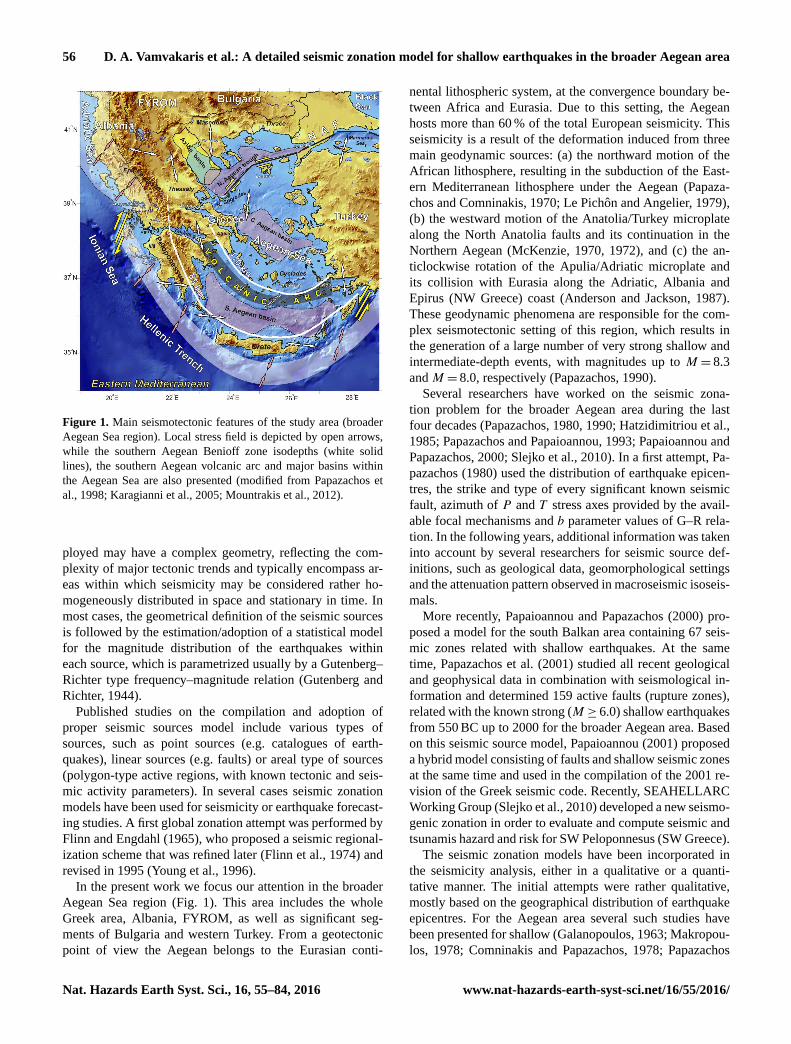
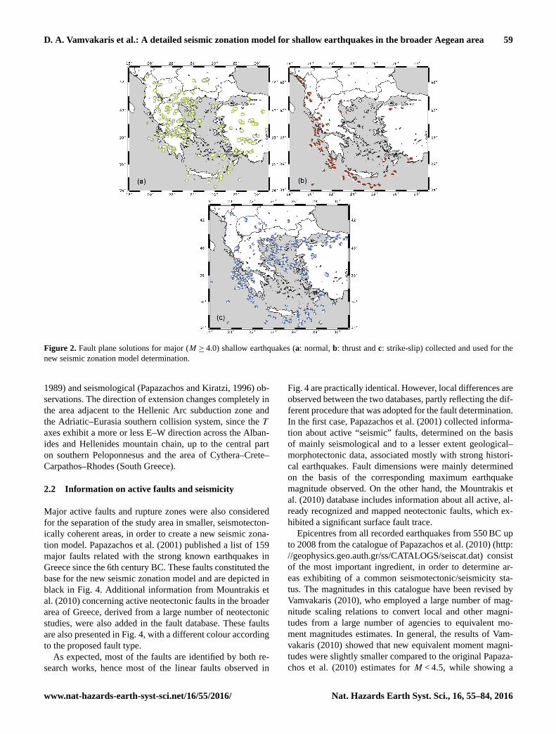
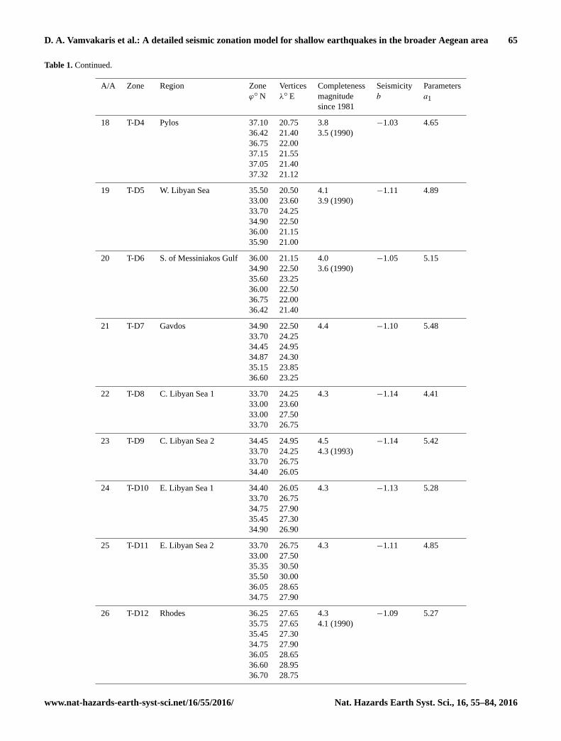
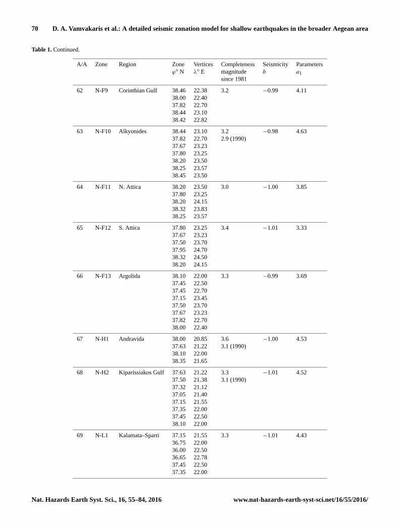