a feature-based geographic information system …...a feature-based geographic information system...
TRANSCRIPT

A Feature-Based Geographic Information System Model
E. Lynn Usery
Abstract A conceptual model for structuring features in a geographic information system (GIS) is presented. The model includes spatial, thematic, and temporal dimensions and structures attributes and relationships for each dimension to build a feature-based GIs. The model is grounded in an entity-based view of geographic phenomena and requires representation of geographic entities as feature objects in GIS. The model is built on concepts from region theory in geography, category theory in cognitive psychology, and dafa modeling theories, including abstraction and generalization concepts in cartog- raphy and G I ~ . The feature construct provides direct access to spatial, thematic, and temporal attributes and relation- ships and thus supports multiple representations and multi- ple geometries, such as raster and vector. The rich structure has potential application for spatial analysis and sophisti- cated geographic process models. Resolution and application dependencies of feature-based systems are discussed with tools to aid in feature determination. Example features are included with parts of the model explicated for these exam- ples.
Introduction The development of geographic information systems (GIs) has advanced to the point that alternative approaches for model- ing geographic phenomena can now be implemented. The conventional map framework based on layers of geography appears inadequate to handle sophisticated geographic pro- cess models and spatial analysis approaches (Goodchild, 1987; Goodchild, 1991; Nyerges, 1991). Few would argue the need to develop better interfaces to GIS in which users are able to name geographic entities and perform analyses on those named entities. The difficulty occurs in whether the underlying data model need reflect these entities directly or whether, through sophisticated data processing, these entities can be presented to the user through conventional layer- based models. This paper is developed from the assumption that the user's perception of geographic reality is one of geo- graphic entities such as roads, buildings, hills, and ethnic immigration areas rather than one of layers of data, and that it is desirable for the data model to directly reflect this per- ception. Given this assumption, the design for an object- based model in which objects are a direct representation of the geographic features rather than of geometric elements such as point, line, and area is developed. This design is re- ferred to as a feature-based geographic information system (FBGIS) because the term "feature" encompasses both the geo- graphical entity and its object representation (NCDCDS, 1988).
In order to model geographic phenomena from reality, some subset of that reality, i.e., an idea of geographic reality, must be developed which reflects a particular application
Department of Geography, The University of Georgia, Room 204, GGS Building, Athens, GA 30602-2502.
PE&RS July 1996
TABLE I. DIMENSIONS, A ~ R I B U T E S , AND RELATIONSHIPS OF THE FBGlS CONCEPTUAL MODEL
Space
Attributes 9, A, Z point, line, area, surface, volume, pixel, voxel, ...
Relationships topology, direction, distance, ...
Theme Time
color, size, date, duration shape, ph, ... period, ...
topology, topology, is - a, is - a, was - a, kind - of, will -be ... part - of, ...
context and resolution of representation. For example, a traff- icability application in terrain analysis requires terrain data modeled as hills, valleys, and other features. One may refer to the spatial analysis literature and find that an infinite complex of geographic entities with infinite attributes must exist; therefore, any given spatial analysis must work with a subset of these infinities (Berry, 1964). The basic characteris- tics of geographic phenomena have been enumerated by vari- ous researchers and consist of space (location), theme [classi- fication or attribute), and time (Berry, 1964; Dangermond, 1983; Nyerges, 1991). Sinton (1978) argued that, of these three dimensions, one is fixed, a second is controlled, and the third is measured. This view is supported in GIS because most data sources are maps, and maps usually fix the time, control the theme, and vary the spatial location.
In order to specify an idea of geographic reality, one must include spatial, thematic, and temporal attributes and relationships. The model of geographic phenomena describes the basic dimensions of any geographic entity (Table 1). Thus, if one describes spatial, thematic, and temporal dimensions for a geographical entity such as a road, one has described an object and thus a feature. A feature is similar to the re- gion concept in geographic research (Grigg, 1965; NCDCDS, 1988; Usery, 1993). For a constrained definition and implementation of regions in G I ~ , see van Roessel and Pullar (1994).
Representation of geographic phenomena in GIs using the layered model focuses on database management and query (Peuquet, 1988; Rhind et al., 1991). This representa- tion structures the locational attributes as basic geometric ob- jects such as points, lines, areas, and pixels (Burrough, 1986; Goodchild, 1987; Goodchild, 1991). Spatial relationships are structured using planar topology with only attribute repre-
Photogrammetric Engineering & Remote Sensing, Vol. 62, No. 7, July 1996, pp. 833-838.
0099-1112/96/6207-833$3.00/0 0 1996 American Society for Photogrammetry
and Remote Sensing
sentation for the third or higher dimensions. The thematic at-
Spatial concepts
image schemata linyistic dependencies nelwork vs geometry
tributes are attached to the basic geometric objects. Thematic relationships are not contained in the layered model except in those cases in which the relationships are intrinsic to the layer. For example, "a church is a building" is a thematic re- lationship which is usually represented in the layered model by including churches in a layer called buildings. Other the- matic relationships, often hierarchical in structure, are not generally represented in the layered model. These include thematic disjunctive relationships such as "the park is a part of the city" when the park is not a part of the corporate lim- its of the city. Spatial disjunction - for example, separated parts of the corporate limits of a city - is supported in lay- ered systems with planar graph enforcement through multi- ple rings, but thematic disjunction requires hierarchy based on thematic relations. Additional difficulties arise with pla- nar graph layered models in handling three-dimensional rela- tionships such as the relation between two roads as over- passinglunderpassing and with dynamic temporal features such as a moving oil spill. Temporal classification is accom- plished as static time slices and temporal relationships as comparisons of multiple time slices.
The FBGIS model focuses on spatial entity modeling and explicitly contains thematic attributes and relationships for three- and higher-dimensional data and temporal phenom- ena. Because the definition of feature reflects both actual geographical entities and their object representations, a fea- ture must include the three dimensions of any geographic phenomenon - space, theme, and time - as shown in Table 1. A feature specified only by spatial location is incomplete; both theme and time are required as a part of the representa- tion (object) and, while these may be fixed attributes of the feature, they are always present for actual geographical enti-
ties. Thus, the FBGIS model includes explicit thematic and temporal dimensions for each feature as well as the spatial location. Furthermore, because these dimensions can be de- scribed by their inherent characteristics andlor by their asso- ciation with other characteristics, both attributes and rela- tionships of each of the dimensions are required to specify a
Thematic concep
experiential-small Lnle formal-large scale
set thew, cawgay rhcary P m t o m
feature. While the FBGIs approach, similar to the geographical
matrix (Berry, 1964), can model an infinite number of attrib- utes and relationships directly, the practical problem of de- termination and implementation of the appropriate set of features for a given application and resolution requires a sub- set of these infinities. One guide to that subset problem can be taken from cartography, in which maps have always been produced for specific applications and at specific resolutions or scales. From the work in cartography, the most relevant research concerns conceptual models and theories of general- ization of geographic phenomena (McMaster, 1991; Nyerges, 1991).
The communication model of cartography, which domi- nated research in that discipline in the 1970s, recognizes the importance of the map user on map design and generaliza- tion processes (Kolacny, 1969; Ratajski, 1973; Morrison, 1976). It is critical that FBGIS be designed with that same under- standing of the user.
The transformational view of cartography also provides concepts to FBGIS development and application (Tobler, 1979; Moellering, 1991). This view supports many of the analytical operations, such as coordinate transformation, thematic over- lay, spatial buffering, and network analysis, which are neces- sary to structure features in forms appropriate for scientific study and analysis.
Because maps are designed to serve specific purposes, a base of knowledge has been developed to guide which fea- tures are appropriate for those purposes. FBGIS can use this knowledge as a starting point to guide the types of features to be structured in databases and knowledge bases and to provide users with the tools to generate new features which do not exist. The digital line graph-enhanced (DLG-E) of the U.S. Geological Survey (USGS) is a feature-based dataset built from this approach (Guptill et al., 1990).
In the next section of this paper, the concepts of an FBGIS are explored in the context of data model theories. The third section further develops the model and provides three exam- ples: a road, a hill, and an oil spill. The fourth section briefly explores some of the potential tools for feature determina- tion. A concluding section discusses the potential of this model.
Temporal concepts
continuous flow time slices
dynamic events
Spatial data models
gcomew fracrals
rasterfvcctor 'Op01ogY relations
FBGIS and Data Model Theories Table 1 captures the essence of the FBGIs model, but the model must be examined in the context of representing geo- graphic phenomena in a way which provides capabilities for producing geographic information useful for spatial decision making. A framework for implementation of the model can be established, and through this framework the logical parts of the model can be explored and implemented.
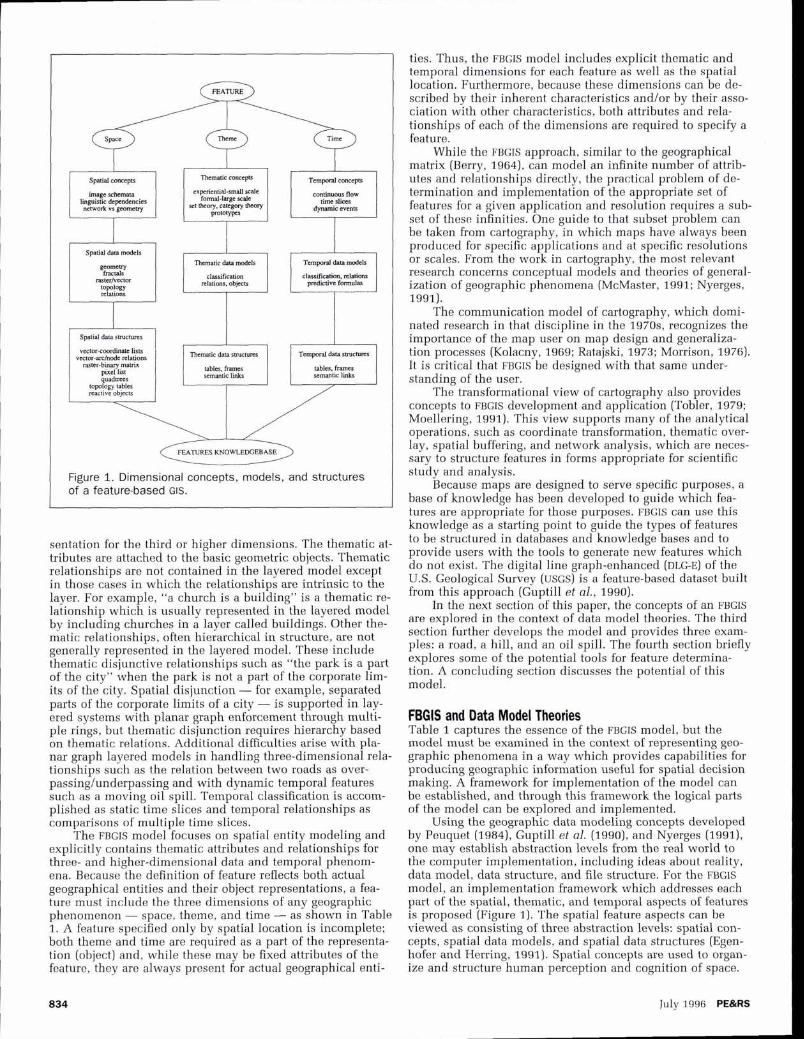
Using the geographic data modeling concepts developed by Peuquet (1984), Guptill et al. (1990), and Nyerges (1991), one may establish abstraction levels from the real world to the computer implementation, including ideas about reality, data model, data structure, and file structure. For the FBGIS model, an implementation framework which addresses each part of the spatial, thematic, and temporal aspects of features is proposed (Figure 1). The spatial feature aspects can be viewed as consisting of three abstraction levels: spatial con- cepts, spatial data models, and spatial data structures (Egen- hofer and Herring, 1991). Spatial concepts are used to organ- ize and structure human perception and cognition of space.
July 19%; PE&RS
Thematic data madels
classifxation relations. objects
Tempord data models
d~sificptim, nhtiom pndidvc formulas
Spatial data swcturrs
vector-coardite lisu vector-archode relations
raster-binary matrix pixel list quadaees
lopolagy tables reactive objects
Figure 1. Dimensional concepts, models, and structures of a feature-based GIS.
T7tematic data rrmctures
tables, frames semantic l i
Temporal data swctures
tables, frames semantic lids
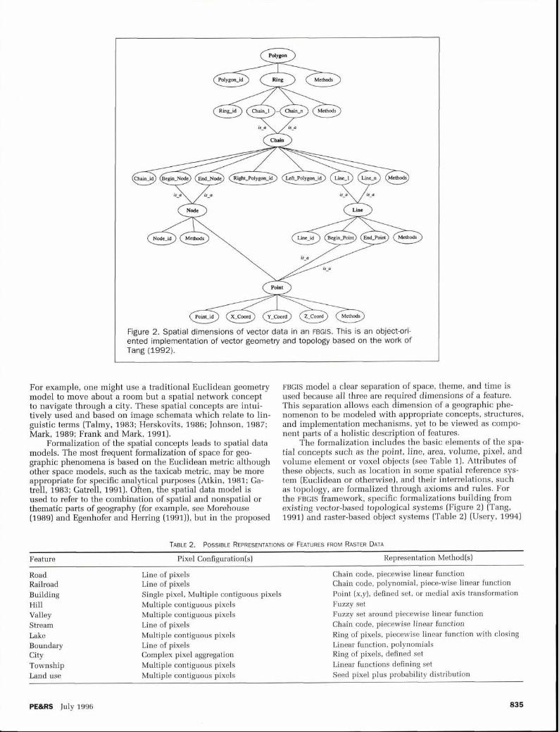
Figure 2. Spatial dimensions of vector data in an FBGIS. This is an object-ori- ented implementation of vector geometry and topology based on the work of Tang (1992).
For example, one might use a traditional Euclidean geometry FBGIS model a clear separation of space, theme, and time is model to move about a room but a spatial network concept used because all three are required dimensions of a feature. to navigate through a city. These spatial concepts are intui- This separation allows each dimension of a geographic phe- tively used and based on image schemata which relate to lin- nomenon to be modeled with appropriate concepts, structures, guistic terms (Talmy, 1983; Herskovits, 1986; Johnson, 1987; and implementation mechanisms, yet to be viewed as compo- Mark, 1989; Frank and Mark, 1991). nent parts of a holistic description of features.
Formalization of the spatial concepts leads to spatial data The formalization includes the basic elements of the spa- models. The most frequent formalization of space for geo- tial concepts such as the point, line, area, volume, pixel, and graphic phenomena is based on the Euclidean metric although volume element or voxel objects (see Table 1). Attributes of other space models, such as the taxicab metric, may be more these objects, such as location in some spatial reference sys- appropriate for specific analytical purposes (Atkin, 1981; Ga- tem (Euclidean or otherwise), and their interrelations, such trell, 1983; Gatrell, 1991). Often, the spatial data model is as topology, are formalized through axioms and rules. For used to refer to the combination of spatial and nonspatial or the FBGIS framework, specific formalizations building from thematic parts of geography (for example, see Morehouse existing vector-based topological systems (Figure 2) (Tang, (1989) and Egenhofer and Herring (1991)), but in the proposed 1991) and raster-based object systems (Table 2) (Usery, 1994)
TABLE 2. POSSIBLE REPRESENTATIONS OF FEATURES FROM RASTER DATA
Feature Pixel Configuration(s) Representation Method(s)
Road Line of pixels Chain code, piecewise linear function Railroad Line of pixels Chain code, polynomial, piece-wise linear function Building Single pixel, Multiple contiguous pixels Point (x,y), defined set, or medial axis transformation Hill Multiple contiguous pixels Fuzzy set Valley Multiple contiguous pixels Fuzzy set around piecewise linear function Stream Line of pixels Chain code, piecewise linear function Lake Multiple contiguous pixels Ring of pixels, piecewise linear function with closing Boundary Line of pixels Linear function, polynomials City Complex pixel aggregation Ring of pixels, defined set Township Multiple contiguous pixels Linear functions defining set Land use Multiple contiguous pixels Seed pixel plus probability distribution
PE&RS July 1996 835
-
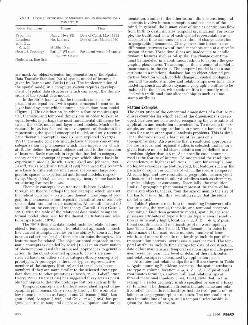
TABLE 3. EXAMPLE SPEC~F~CAT~ON OF ATTRIBUTES AND RELATIONSHIPOS FOR A
ROAD FEATURE
Space: Euclidean Theme Time
Type: line Name: Hwy PD Date of Const: May, 1982 Location: No. Lanes: 2 Date of Last Maint: 1989 4, A, z ...
4, A, Z Width: 10 m Network Topology Part of: WI state Pavement wear: 0.5 cm/yr
highway system Node, area, line lists
are used. An object-oriented implementation of the Spatial Data Transfer Standard (SDTS) spatial model of features is given by Barnett and Carlis (1994). The implementation of the spatial model in a computer system requires develop- ment of spatial data structures which can accept the dimen- sions of the spatial data model.
In the FBGIs framework, the thematic concepts are placed at an equal level with spatial concepts in contrast to layer-based systems which assume a space dominant model (Figure 1). This distinction, in which a feature requires spa- tial, thematic, and temporal dimensions in order to exist at equal levels, is perhaps the most fundamental difference be- tween the FBGIs model and layer-based models. Much of the research in GIS has focused on development of databases for representing the spatial conceptual model, and only recently have thematic conceptual models been explored (Nyerges, 1991). Thematic concepts include basic theories concerning categorization of phenomena which have impacts on which attributes define the spatial objects and lead to the formation of features. Basic research in cognition has led to category theory and the concept of prototypes which offer a basis in experiential models (Rosch, 1978; Lakoff and Johnson, 1980; Lakoff, 1987). Mark and Frank (1990) have used this research as a basis to differentiate small areal spaces and large geo- graphic spaces as experiential and formal models, respec- tively. Usery (1993) has used category theory as one basis for structuring features in a GIs.
Thematic concepts have traditionally been explored through set theory. Perhaps the best example which uses set theoretical constructs to structure thematic groupings of geo- graphic phenomena is multispectral classification of remotely sensed data into land-cover categories. Almost all current GIS are built on the concepts of set theory (Gatrell, 1983; Gatrell, 1991) with the table of the relational data model being the formal model often used for the thematic attributes and rela- tionships (Codd, 1970).
The FBGIS thematic data model includes relational and object-oriented approaches. The relational approach is much like current attempts. It relies on the ability to construct fea- tures as collections (sets) of thematic attributes through which features may be related. The object-oriented approach to the- matic concepts is detailed by Mark (1991) in an examination of phenomenon-based (feature-based) approaches to generali- zation. In the object-oriented approach, objects are con- structed based on either sets or category-theory concepts of prototypes. A prototype is the most typical representative member of the category (feature) and other objects become members if they are more similar to the selected prototype than they are to other prototypes (Rosch, 1978; Lakoff, 1987; Usery, 1993). Usery (1994) has suggested fuzzy sets as possi- ble techniques to describe prototype features such as hills.
Temporal concepts are the least researched aspect of ge- ographic phenomena. Only recently through the work of a few researchers such as Langran and Chrisman (1988), Lan- gran (1989), Langran (1992), and Greve et al. (1993) has pro- gress occurred in temporal database development and imple-
mentation. Similar to the other feature dimensions, temporal concepts involve human perception and schemata of the mind. In general, the human view of time as continuous flow from birth to death dictates temporal organization. For exam- ple, the traditional view of each spatial representation as a snapshot in time accounts for our ideas of change detection in geographic phenomena. Change over time becomes the differences between two of these snapshots each at a specific instant of time. These time slices are inadequate to handle dynamic features such as oil spills. The change over time must be modeled in a continuous fashion to capture the geo- graphic phenomena. To accomplish this, a temporal model is incorporated in the FBGIS. The temporal model is not a static attribute in a relational database but an object-oriented pre- dictive function which models change in spatial configura- tion and thematic attributes and relationships over time. This modeling construct allows dynamic geographic entities to be included in the FBGIS, with static entities temporally mod- eled with traditional time-slice techniques such as time- stamp attributes.
Feature Examples The description of the conceptual dimensions of a feature re- quires examples for which each of the dimensions is devel- oped. Features are constructed recognizing the constraints of application and resolution dependencies. To develop the ex- ample, assume the application is to provide a base set of fea- tures for use in other spatial analysis problems. This is simi- lar to the provision of a basic set of features on a topographic map. Also assume that a resolution appropriate for use in local and regional studies is selected; that is, for a given feature no spatial characteristics can be defined to a precision higher than 0.5 m. As a specific case, assume a road is the feature of interest. To understand the resolution dependency, at higher resolutions, 0.5 mm for example, one no longer examines the feature, road, but features such as the particles of asphalt or concrete of which the road is composed. At some high and low resolutions, geographic features yield to features of interest to other disciplines such as chemistry, physics, biology, or astronomy. Essentially, the resolution limits of geographic phenomena represent the realm of hu- man-sized objects, that is, from the size of man to the size of the Earth. It is within this resolution range that the FBGIS model is cast.
Table 3 places a road into the modeling framework of a feature using the spatial, thematic, and temporal concepts. Assuming a Euclidean geometric model, spatially, the road possesses attributes of type = line (or type = area if resolu- tion is sufficiently high), location = 4, A, Z ... 4, A, Z posi- tional coordinates; and relationships of network topology (see Table 3 and also Table 1). The thematic attributes in- clude name of the road, route number, number of lanes, width, and others; thematic relationships include part of = transportation network, overpasses = another road. The tem- poral attributes include time stamps for date of construction, date of last maintenance; temporal relationships include pave- ment wear per year. The level of detail of these attributes and relationships is determined by application needs.
Attributes and relationships for a hill are shown in Table 4. Again assuming Euclidean geometry, the spatial attributes are type = volume, location = 4, A, Z ... 4, A, Z positional coordinates forming a convex hull; and relationships of three-dimensional topology (Tsai, 1994). Note that, in this example, a raster geometry is also specified by use of a fuzzy set function. The thematic attributes include name and rela- tive relief. Thematic relationships include two "part - of" re- lations to larger geomorphic structures. The temporal attrib- utes include time of origin, and a temporal relationship is given for the rate of erosion.
July 1996 PE&RS

TABLE 4. EXAMPLE SPECIFICATION OF ATTRIBUTES AND RELATIONSHIPS FOR A HILL FEATURE
TABLE 5. EXAMPLE SPECIFICATION OF AT~RIBUTES AND RELATIONSHIPS FOR A N OIL SPILL FEATURE
Space: Euclidean Theme Time Space: Euclidean Theme Time
Type: volume Name: Blue Mounds Date: 10,000 BC (west]
Location: Relative relieE 200 m 4,A,Z . . .
4, A, Z Volume Topology Part of: Blue Erosion: 0.5 cm/yr
Mounds Node, line, area, volume Part of: Wisconsin
lists Driftless
Table 5 places an oil spill in the modeling framework. With Euclidean geometry, the spatial attributes are type = volume, location = 4, A, Z ... 4, A, Z positional coordinates forming a convex hull; and relationships of three-dimen- sional topology. The thematic attributes include size, shape, oil characteristics, and others; thematic relationships include outflow from source and impact on other features. The tem- poral attributes include time and date spill occurred, time and date of modifying operations such as cleanup, and oth- ers; temporal relationships include rate of change of size, speed, and direction of movement with respect to the water and other features.
The dependencies which become obvious in an attempt to explicate the complete set of attributes and relationships for a specific feature dictate a need for users to have tools to develop features as needed &om basic geographic data. These features, once developed, may be stored if desired or used only as the application requires. The feature development tools must be implementations of the basic modeling con- cepts which spatial analysts use to construct features. As such, the tools require both simple techniques such as count- ing and summation and sophisticated methods for modeling human cognition. Examples of these tools are developed in the next section.
Feature Determination The concept of F B G I ~ requires some method of determining features which are appropriate for inclusion in the knowl- edge and databases which support user applications. That determination is usually dependent on the particular applica- tion and has traditionally been performed in spatial analysis studies through the experience of the analyst. While FBGIS approaches cannot replace the analyst and judicious selec- tion of geographic entities for a particular study, these sys- tems can aid the user in development of such features. As a starting point, a set of base features which have been auto- matically developed from the system databases will exist in the features knowledge base. The assumption is that a base set of geographic data roughly corresponding to the digital equivalent of large-scale topographic maps for the study area already exists in the FBGIS databases. For example, DLG-E is one such database currently being developed. From these da- tabases a set of universal features are determined and placed in the knowledge bases. It is the user application which will determine needs beyond this basic set.
The variety of applications requires a dynamic feature determination system capable of learning. For example, in a terrain analysis application, a user may want to build fea- tures which determine the trafficability of a surface by partic- ular types of vehicles. The FBGIS can provide the base set of terrain features to the user for review. If this is insufficient, then the user can specify requirements including spatial, the- matic, and temporal attributes and relationships, for features to be added to the system. Assuming appropriate data exist
Type: volume Type: Crude Oil Date: 5/34/87 Size: 5,000,000 m3 Cleanup: 5/4/87
Location: 4, A, Z
4, A, Volume Topology Outflow From: Rate of Size
Tanker Change: Node, line, area, volume Features in Path: 1,000 m3 per day
lists Alaska coast Direction: NW Movement: 3 km/
hr
in the databases, these new features can be generated and added to the set of system features. The next user requesting features for a similar application will be shown the base set plus the new features defined by this application.
The actual methods of feature determination from data- bases require a combination of database retrieval and data processing routines, such as those contained in a relational database management system, and standard spatial process- ing tools such as overlay and spatial buffering. These data- base and spatial tools must be tightly interfaced to a set of statistical and analytical processing tools such as multispec- tral classification, factor analysis, multidimensional scaling, and q-analysis. Data reduction and presentation of the results to the user for final confirmation of the feature's correctness are prerequisite tasks.
Conclusions A conceptual modeling framework for a feature-based ap- proach to GIS has been presented. The model explicitly in- cludes spatial, temporal, and thematic dimensions and is firmly grounded in region theory from geography, category theory from cognitive psychology, and data modeling theo- ries developed in cartography and GIS. This model holds po- tential for effectively representing geographic entities. The model is not constrained to map and layered representations of geography and can represent three- and higher-dimensional entities and temporal events. Multiple spatial representa- tions, such as raster and vector geometries, of geographic phenomena are directly supported by the model.
Acknowledgments This research was supported by the University of Wisconsin- Madison Graduate School, the IBM Corporation, and ERDAS, Inc.
References Atkin, R.H., 1981. Multidimensional Man, Penguin Books, Middle-
sex. Barnett, L., and J.V. Carlis, 1994. Feature Information Support and
the SDTS Conceptual Data Model: Clarification and Extension, Auto-Carto 11, Minneapolis, pp. 132-144.
Berry, B.J.L., 1964. Approaches to Spatial Analysis: A Regional Syn- thesis, Annals of the Association of American Geographers, 54: 2-11.
Burrough, P.A., 1986. Principles of Geographical Information Sys- tems for Land Resources Assessment, Clarendon Press, Oxford, 194 p.
Codd, E.F., 1970. A Relational Model of Data for Large Shared Data Banks, Communications of the ACM, 13(6):377-387.
Dangermond, J., 1983. A Classification of Software Components Commonly Used in Geographic Information Systems, Design and Implementation of Computer-Based Geographic Information Sys-
PE&RS July 1996

tems (D.J. Peuquet and J. O'Callaghan, editors), IGU Commission of Geographical Data Sensing and Data Processing, Amherst.
Egenhofer, M.J., and J.R. Herring, 1991. High-Level Spatial Data Structures for GIs, Geographical Information Systems: Principles and Applications, Volume 1 (D.J. Maguire, M.F. Goodchild, and D.W. Rhind, editors), Longman Scientific Publications, London, pp. 227-237.
Frank, A.U., and D.M. Mark, 1991. Language Issues for GIs, Geo- graphical Information Systems: Principles and Applications, Volume 1 (D.J. Maguire, M.F. Goodchild, and D.W. Rhind, edi- tors), Longman Scientific Publications, London, pp. 147-163.
Gatrell, A.C., 1983. Distance and Space: A Geographical Perspective, Clarendon Press, Oxford, 195 p.
, 1991. Concepts of Space and Geographical Data, Geographi- cal Information Systems: Principles and Applications, Volume 1 (D.J. Maguire, M.F. Goodchild, and D.W. Rhind, editors), Long- man Scientific Publications, London, pp. 119-134.
Goodchild, M.F., 1987. A Spatial Analytical Perspective on Geo- graphic Information Systems, International Journal of Geographi- cal Information Systems, 1(4):327-334.
, 1991. Spatial Analysis with GIs: Problems and Prospects, Proceedings, GIS/LIS '91, Atlanta, pp. 40-48.
Greve, C.W., J.A. Kelmelis, R. Fegeas, S.C. Guptill, and N. Mouat, 1993. Investigating U.S. Geological Needs for the Management of Temporal GIs Data, Photogrammetric Engineering b Remote Sensing, 59(10):1503-1508.
Grigg, D., 1965. The Logic of Regional Systems, Annals of the Asso- ciation of American Geographers, 55:465-491.
Guptill, S.C., K.J. Boyko, M.A. Domaratz, R.G. Fegeas, H.J. Ross- meissl, and E.L. Usery, 1990. An Enhanced Digital Line Graph Design, U.S. Geological Survey Circular 1048, Reston, Virginia.
Herskovits, A,, 1986. Language and Spatial Cognition: An Interdisci- plinary Study of the Prepositions in English, Cambridge Univer- sity Press, Cambridge, 208 p.
Johnson, M., 1987. The Body in the Mind: The Bodily Basis of Mean- ing, Imagination, and Reason, University of Chicago Press, Chi- cago, 233 p.
Kolacny, A., 1969. Cartographic Information - A Fundamental Con- cept and Term in Modern Cartography, The Cartographic Jour- nal, 6(4):47-49.
Lakoff, G., 1987. Women, Fire, and Dangerous Things: What Catego- ries Reveal about the Mind, University of Chicago Press, Chi- cago, 614 p.
Lakoff, G., and M. Johnson, 1980. Metaphors We Live By, University of Chicago Press, Chicago, 242 p.
Langran, G., 1989. A Review of Temporal Database Research and Its Use in GIs Applications, International Journal of Geographical Information Systems, 3(3):215-232.
, 1992. Time in Geographic Information Systems, Taylor and Francis, Basingstoke, England, 189 p.
Langran, G., and N. Chrisman, 1988. A Framework for Temporal Ge- ographic Information, Cartographica, 25(1):1-14.
Mark, D.M., 1989. Cognitive Image-Schemata for Geographic Infor- mation: Relations to User Views and GIs Interfaces, GIS/LIS '89, Orlando, Florida, 2:551-560.
Mark, D.M., 1991. Object Modelling and Phenomenon-Based Gener- alization, Map Generalization: Making Decisions for Knowledge Representation (B.P. Buttenfield and R.B. McMaster, editors), Longman Scientific Publications, London, pp. 103-118.
Mark, D.M., and A.U. Frank, 1990. Experiential and Formal Models of Geographic Space, NCGIA Technical Report 90-10, University of California, Santa Barbara, California.
McMaster, R.B., 1991. Conceptual Frameworks for Geographical Knowledge, Map Generalization: Making Decisions for Knowl- edge Representation (B.P. Buttenfield and R.B. McMaster, edi- tors), Longman Scientific Publications, London, pp. 21-39.
Moellering, H., 1991. Whither Analytical Cartography?, Cartography and GIs, 18(1):7-9.
Morehouse, S., 1989. The Architecture of ArcJInfo, Proceedings, Auto-Carto 9, Baltimore, pp. 388-397.
Morrison, J.L., 1976. The Science of Cartography and Its Essential Processes, The International Yearbook of Cartography, George Phillip and Son, Ltd., 16:84-97.
NCDCDS, 1988. A Proposed Standard for Digital Cartographic Data, National Committee on Digital Cartographic Data Standards, The American Cartographer, 15(1):1-140.
Nyerges, T.L., 1991. Representing Geographical Meaning, Map Gen- eralization: Making Decisions for Knowledge Representation (B.P. Buttenfield and R.B. McMaster, editors), Longman Scien- tific Publications, pp. 59-85.
Peuquet, D.J., 1984. A Conceptual Framework and Comparison of Spatial Data Models, Cartographica, 21(4):66-113.
, 1988. Representations of Geographic Space: Toward a Con- ceptual Synthesis, Annals of the Association of American Geog- raphers, 78(3):375-394.
Ratajski, L., 1973. The Research Structure of Theoretical Cartogra- phy, The International Yearbook of Cartography, George Phillip and Son, Ltd., 13:217-228.
Rhind, D.W., M.F. Goodchild, and D.J. Maguire, 1991. Epilogue, Geo- graphical Information Systems: Principles and Applications, Volume 2 (D.J. Maguire, M.F. Goodchild, and D.W. Rhind, edi- tors), Longman Scientific Publications, London, pp. 313-327.
Rosch, E., 1978. Principles of Categorization, Cognition and Categori- zation (E. Rosch and B.B. Lloyd, editors), Halstead Press, New York, pp. 27-48.
Sinton, D., 1978. The Inherent Structure of Information as a Con- straint to Analysis: Mapped Thematic Data as a Case Study, Harvard Papers on Geographic Information Systems, Volume 6 (G. Dutton, editor), Addison Wesley, Reading, Massachusetts.
Talmy, L., 1983. How Language Structures Space, Spatial On'enta- tion: Theory, Research, and Application (H. Pick and L. Acre- dolo, editors), Plenum, New York, pp. 225-282.
Tang, A.Y., 1991, Data Model Design for a Feature-Based GIs, un- published Master's Thesis, Department of Geography, University of Wisconsin-Madison, Madison, Wisconsin, 91 p.
Tobler, W., 1979. A Transformational View of Cartography, The American Cartographer, 6(2):101-106.
Tsai, V.J.D.. 1994. Towards an Integrated Three-Dimensional Geo- graphic Information System, unpublished Ph.D. Dissertation, University of Wisconsin-Madison, 227 p.
Usery, E.L., 1993. Category Theory and the Structure of Features in GIS, Cartography and GIs, 20(1):5-12.
, 1994. Implementation Constructs for Raster Features, Pro- ceedings, ASPRSIACSM Annual Convention, Reno, Nevada, pp. 661-670.
van Roessel, J., and D. Pullar, 1994. Geographic Regions: A New Composite GIs Feature Type, Auto-Carto 11, Minneapolis, pp. 145-156.
(Received 11 July 1994; accepted 11 October 1994)
See the Instructions to Authors on page 862 to find out how to submit your work for publication in PE&RS .
July 1996 PE&RS