a framework for natural disaster memorial park design · a framework for natural disaster memorial...
TRANSCRIPT

A FRAMEWORK FOR NATURAL DISASTER MEMORIAL PARK DESIGN
— 5/12 EARTHQUAKE MEMORIAL PARK DESIGN
By
LINJUN YANG
A thesis submitted in partial fulfillment of
the requirements for the degree of
MASTER OF SCIENCE IN LANDSCAPE ARCHITECTURE
WASHINGTON STATE UNIVERSITY
Department of Horticulture and Landscape Architecture
DECEMBER 2010

ii
To the Faculty of Washington State University:
The members of the Committee appointed to examine the thesis of LINJUN
YANG find it satisfactory and recommend that it be accepted.
________________________________
David Wang, Ph.D., Chair
________________________________
Bob Scarfo, Ph.D.
________________________________
Jolie B. Kaytes, Ph.D.

iii
Acknowledgments
The author would like to thank all those who supported her during the writing,
research, and theorizing of the following thesis exploration.
She would like to thank all the local people and visitors for their great help at the
time of performing the Wenchuan earthquake site survey and interviews. Their kind
hospitality in allowing her to interview and photograph them has contributed greatly to
her knowledge of 5/12 earthquake and memorial parks.
The author extends an overwhelming thanks to those on her committee, David
Wang, Bob Scarfo, and Jolie B. Kaytes, for their support and guidance throughout this
inquiry‘s development. Their encouragement, guidance, and everlasting patience has
enabled a very large idea to be narrowed down to an opportunity of a lifetime.
Finally, she would like to thank those who continually encouraged and supported
her through all the ups and downs of these past years. Her mother, father, family, and
friends have guided her in the finest positive ways and have, in turn, contributed to a
thorough completion of this thesis.

iv
A FRAMEWORK FOR NATURAL DISASTER MEMORIAL PARK DESIGN
— 5/12 EARTHQUAKE MEMORIAL PARK DESIGN
Abstract
By Linjun Yang, M.S.L.A
Washington State University
December 2010
Chair: David Wang
An earthquake with a magnitude of 8.0 on the Richter scale rocked Sichuan on May
12, 2008, eventually claiming 69,227 lives, and 374,643 injured.1 The quake toppled
houses and schools, virtually destroying entire villages, and irreparably changed
everyone‘s world there. The quake severely affected an estimated 45,547,565 residents
in Sichuan province, damaged approximately 4,300,000 structures, and destroyed
buildings including homes, businesses, schools, and hospitals. Thousands of innocent
people lost their precious lives in this disaster. Among these people, there were young
students reading out beautiful poems in books; there were mamas preparing hot milk for
their kids in the morning; there were…however, those bright lives, at that moment, all
became cold numbers in the history books.
A natural disaster memorial park is needed to memorialize all the survivors and
victims of this great disaster, to tell stories of survival and loss, to encourage people
surmounting the tragedy bravely, and to provide a refuge for future disasters.
Throughout the research conducted after the May 12 earthquake, the author has
observed that no integrated system of planning and design has been established in
1Bin Zhao and Taucer Fabio, ―Field Investigation on the Performance of Building Structures During the
12 May 2008 Wenchuan Earthquake in China.‖ Engineering Structures 31. no. 8 (August, 2009):
1707-1723.

v
natural disaster memorial park design. The thesis defines the conception of a memorial
landscape and natural disaster memorial park, reviews the history of natural disaster
memorial parks, and sorts through many cases of memorial parks.
A general design guideline and theory for natural disaster memorial park design
will be summarized from case studies, and this guideline will be interpreted particularly
in terms of the 5/12 Earthquake Memorial Park design in China.
The result of this research is an extension of an overall knowledge base and a
theory explaining the difference between ―natural disaster memorials‖ and ―war
memorials‖ design and summarizing the basic elements that constitute the physical and
psychological characteristics of natural disaster memorial park design. The 5/12
Earthquake Memorial design will be a new application of the integration of the new
theory about Natural Disaster Memorial Landscape design and will provide guidance
and reference for park planners and designers to promote multiple functions in
memorial park design in the future.

vi
Table of Contents
Page
Acknowledgments ………………………………..………………………...……….....iii
Abstract…………………………………………..…………………………….………iv
List of Figures……………….……………………………….……………....…….…viii
Chapter One: Introduction
1.1 Introduction………………………………………………………..…….……...1
1.2 Research Question and Purpose……………………………….………….…….1
1.3 Key Definition……………………………………..……………………….…...2
Chapter Two: Literature Review and Case Study
2.1 Overview……………………………..………………...……………….………4
2.2 Literature Review……………………………..………………..………….……4
2.3 Summary of Literature Review…………………………………..……….….…9
2.4 Case Study………………………………………..………………...…….……14
2.5 The Comparison Chart of W.M.P. and N.D.M.P…………………………...….66
2.6 Summary of the Case Study………………………………………..…….……68
Chapter Three: Methodology and Survey Results
3.1 Research & Methodology………………………………..……………….……70
3.2 Procedure………………………………………..………………………….….70
3.3 Results…………………………………………..………………………….….71
3.4 Discussion…………………………………………..………………….…...….77
3.5 Key Principles which can be applied to N.D.M.P…………………….……… 80
Chapter Four: 5.12 Wenchuan Earthquake Memorial Park Design
4.1 Design Strategies…………………………………………..……………….….88
4.2 Site Selection…..................................................................................................89

vii
4.3 Project Goals……………………………………………..………………..…...90
4.4 Final Sheets……………………………………………..……………….…….92
4.5 Summary of the 5/12 Wenchuan Memorial Park Design……………….……134
4.6 Summary of the Design Project………………………………………………136
4.7 Analysis of Project………………………………………..………….….……136
4.8 Limitations and Further Application…………………………..…….….…….136
4.9 Strengths and Weaknesses…………………………………..………...……...137
Bibliography…………..…………………………..………………………………….139
Appendices………………………………………..………………………………….143
Appendix A: Questionnaire and Results of the 5.12 Earthquake Site Survey…....144
Appendix B: Presentation Posters…………………..…………………….….......151
Appendix C: Case Study Checklist…………………………..………………...…157

viii
List of Figures
Page
1. Catch Basin………...….……………………….…………………………….………13
2. Catch Basin………………………………………………..………...……….………13
3. Vietnam Veterans Memorial…………………………..……………………….….…15
4. Vietnam Veterans Memorial………………………………………………...…….…15
5. Names Etched in Granite Send a Timeless Message……………..…….….……...…16
6. Deportation Memorial…………………………..…………………..…..…….….….17
7. Deportation Memorial…………………………..………….………………….…….17
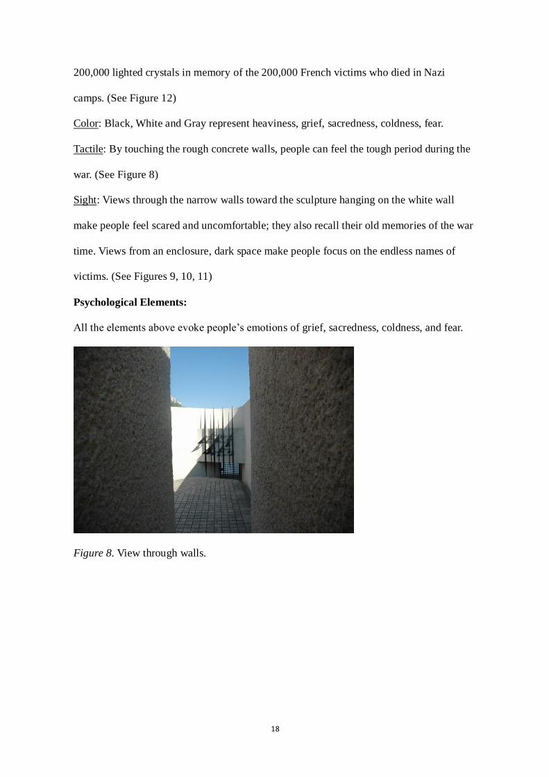
8. View through Walls…………………………………..…...………..………….…….18
9. Entrance.…………….…………………..……..……………...………………….….19
10. Symbolism…………..…………………..………………...……………….……….19
11. Symbolism…………..………………..…..……..………………………….……....19
12. Endless Names—Crystal-lined Hall in Deportation Memorial.……………….…...19
13. Eight-acre Memorial Quadrant………………….…..………………………….…..20
14. USS Arizona Memorial (USAR)……………………..…...……………...…….…..22
15. Nanjing Massacre Memorial Hall…...………….………….…………….........……24
16. Exhibition hall……………...…...………..…………………………………..….…24
17. Sculptures…………………..….…………………………………….…..............…24
18. Nanjing Massacre Memorial …...…………………..…………………...........……25
19. Berlin Holocaust Memorial…………………………..………………..…..…….…26
20. Earthquake……………….……….…..………………………………..……...……28
21. Tsunami………………….………...…………………………………………..……28
22. Typhoon/ Hurricane……...……….…………..…………….……………...…….…28
23. Flood……………………..………...………………………………………….……28

ix
24. Fire……….………………………...……………………………………....……….27
25. Kobe Port Earthquake Memorial Park……………………………..………....….…29
26. Kobe Port Earthquake Memorial Park……………………………..……….........…30
27. Kobe Port Earthquake Memorial Park………………………………..……….…....30
28. Kobe Port Earthquake Memorial Park………………………………..…….........…30
29. Kobe Port Earthquake Memorial Park……………………………..……...……..…30
30. Kobe Port Earthquake Memorial Park……………………………..……….........…30
31. Kobe Port Earthquake Memorial Park……………………………..………….....…31
32. Kobe Port Earthquake Memorial Park…………………………..……………….…31
33. Smriti Van Earthquake Memorial……………………..……...………………….…33
34. Smriti Van Earthquake Memorial……………………..……...………….…………33
35. Taiwan Chi-Chi Earthquake Memorial……………………..………………............34
36. Taiwan Chi-Chi Earthquake Memorial……………………..………………............35
37. Ruins after Tangshan quake……...……….………..…………….……………...….36
38. Railroad.…………………….....…..………………………………………........….36
39. Tangshan Earthquake Memorial Park…………………………..………...……..….38
40. Tangshan Earthquake Memorial Park…………………………..………….........….38
41. The Ruins………………………..…...…………………………………….…….…39
42. 300-meter Memorial Walls (with 240,000 Names)……………………..…....…….39
43. Tangshan Earthquake Memorial Hall………………………...………….………....39
44. Educational Display…………………….……………….………………….……....39
45. Ceremony…………………………..…………...………………….……..…......….39
46. Tsunami Memorial in Khao Lak…………………………….…...……………...….41
47. Tsunami Memorial in Khao Lak…………………………..……….…….……..…..42
48. Hurricane Katrina…………………………..………………….…….…….…….....43

x
49. Hurricane Katrina …………………….....………………………............................43
50. Daytime……………………..………...………………………………...…….…....43
51. Nighttime…………………..…………….……………………………...……….....43
52. Prayers……………………..……………………….………………………....…....43
53. Memorial Wall………………………..…….………………………………....…....44
54. Memorial Wall…………………………..….……………………............................44
55. Relief Art Sculptures………………….……………..………………………….….45
56. Bronze Plaque………………....…..……………………………….……..……..….45
57. The Florida Keys Memorial…………………..……..…………….….…………….45
58. Crypt is Covered with a Map of the Upper Keys..……....…………..………….….46
59. Wuhan 1954 Flood Memorial………………..…………………………….…….…47
60. Wuhan 1954 Flood Memorial………………..……………….………………….…48
61. Aftermath of the Fire, Corner of Dearborn and Monroe Street…………….............49
62. Chicago Fire Memorial……………..…….……...…………………………….…...49
63. Chicago Fire Memorial……………..…….……...…………………………….…...49
64. Municipal Flag of Chicago……………..…….……......…………………........…...49
65. A Marker Commemorating the Fire outside the Chicago Fire Academy....…..........50
66. Chicago Firefighters Memorial……………..……………………….……..……....50
67. Chicago Firefighters Memorial……………...…...….……………..……………....50
68. Japan Hanshin Awaji earthquake, 1995………………..….…………………….….51
69. Japan Hanshin Awaji earthquake, 1995………………...……………………….….51
70. Osu Disaster Prevention Park……………..……………………………………..…51
71. Osu Disaster Prevention Park……………..………………….......……………...…51
72. Osu Disaster Prevention Park………...……..………….……………………….….51
73. Disaster Prevention Facilities Management……..…………..…………………..…52

xi
74. Master Plan and Emergency Escape Information….…..………………………..…52
75. Wuhan Riverside Park……………..……………………………………...……..…54
76. Wuhan Riverside Park……………..……………………………………....…….…55
77. Wuhan Riverside Park………………..…………………………………....…….…55
78. Wuhan Riverside Park……………..………………………………….…...…….…55
79. Martin Luther King Memorial Park…………..………………………...……….…56
80. ―Stone of Hope‖………..………………...……………………………...……….…56
81. A model of the Martin Luther King, Jr. National Me..…………..……...…….……57
82. A model of the Martin Luther King, Jr. National Me..……………..…...…….……57
83. A model of the Martin Luther King, Jr. National Me..……………..…...…….……57
84. The Washington Monument in Washington D.C…………………..…………...…..58
85. Church on the Water…………………………………………..……………….…...59
86. Church on the Water…………………………………..……………………….…...59
87. Interior Space…………………………………..……..…………….…………...….60
88. Interior Space of the Church..…………………………………..……….……...….60
89. Interior Space of the Church..………………………………..……………..…..….60
90. Interior Space of the Church..……………………………..………………..…..….60
91. Qijiang Park in Zhongshan City…………………………………..……...…….…..62
92. The Red Box……………………………………………………………...………...62
93. The Rust Rails………………..……………..……..……………………...………...62
94. Master Plan, Zhongshan Shipyard Park………………………………….…….…..63
95. Entrance Gate…………………………………..…..……………………….…...…65
96. Nanjing Dr. Sun yat-sen's Mausoleum…………………………..……….……...…65
97. Entrance Gate………………………………..…..………………………….…...…65
98. Comparison Form of W.M.P and N.D.M.P……………………………....…………66

xii
99. The Result of Question 1……………………...……………..………………...…...71
100. The Result of Question 2…………...…………………………………..………....71
101. The Result of Question 3……….……………………………..……………...…...72
102. The Result of Question 4………………………………….………………….…...73
103. The Result of Question 5……………...……………………..……………….…...73
104. The Result of Question 6…………...……………………..………………….…...74
105. The Result of Question 7………………...………………..……………………....74
106. The Result of Question 9...…………………………………..…………………....75
107. The Result of Question 10…………………………………...…………………....76
108. The Result of Question 11.…………………………………..…………………....76
109. The Result of Question 12….………………………………..…………………....77
110. Three Development Periods of Feelings.………..………………..…………….....78
111. Site Location…....……………………..………………………………...………...92
112. Before Quake……………..………………..……………………………………...93
113. After Quake………………………………...……………………………………...93
114. Tourist Map of Earthquake Ruins and Surrounding Area…………….…………...94
115. Government- proposed Design Boundary.………….…………………...……..….97
116. Central Area……………...…………....….………………...………………….….98
117. Central Area……………...…………..…...………………...………………….….98
118. Local Plants -- Bamboo……..………………..……………………..……..….…100
119. Stone Paving.………………………………..……………..………..………...…100
120. Native Animals -- Panda.………………...………………………....………..…..100
121. Emergency Sign.….……………………………………..………………….....…103
122. Evacuation Radius.…...……………...………..…..…….………………….....…103
123. The Ruins of Yingxiu Middle School.……………….…………….…...…..……105

xiii
124. Tianbeng Rock…………………………………….…………………….....…….105
125. Bird‘s Eye View………………………………………..…….…….….........……105
126. Niumian Gou Entrance Rock…..……………….………………….……...…..…106
127. The Quake Lake -- Landslide Dam……………..………………..……..…….…106
128. Houses Collapsed…………...….………..……….…………………..……….…106
129. Lianhua Xin Waterfall…………………….……….…………..…….………..…106
130. Broken Bridge…………………………….……….………..……………………106
131. Broken Bridge…………………………….……….………..……….…….….…106
132. Broken Bridge…………………………….……….………..……….………..…106
133. Looking over from Yuzixi Viewing Platform………………………..………..…107
134. Temporary Refuges-- Prefabricated Housing……..…….……….……..……..…107
135. Earthquake Statues -- Bulrush………………………..………….……..……..…107
136. Earthquake Statues -- Chicken……………………...…………….…………..…107
137. Altar and Cemetery…………………………...….……………….…………..…107
138. Altar and Cemetery……………………….…..….………………….……….….107
139. Stone Houses Submerged in Flood.…...…………………..………....……….…108
140. Floating Lanterns…………..................................................................................109
141. Releasing Lanterns…………...…………………..………….………………..…109
142. Conceptual Plan……………………………………..……………………...……112
143. The Functional Grouping and Zoning Map in Ordinary Times……...……..……114
144. The Functional Grouping and Zoning Map During the Disaster.…..…….…...…115
145. Planting Plan………………….…………………………………..……………...121
146. Planting Plan………………….……...………………………..…………….…...122
147. The design process of Museum.…………………..……...……...……….….…..123
148. Master Plan…………………………………...……………………...…………..125

xiv
149. Memorial Path with Milestone……..…………………...…..……….……….….126
150. Memorial Wall.………………..………………………...……..……….…….….127
151. Paper Lanterns.……………..…………………………...……..……….…….….128
152. Master Plan……………………………………………...……..……….…….….129
153. A—A‘ Section Plan.…………………………….…………...…………….….….130
154. B—B‘ Section Plan.………………...…………..….……….………………...….131
155. C—C‘ Section Plan.…………………...………..….…….....……………..….….131
156. Memorial Bridge………..……..………………….……......….……………...….132
157. Memorial Walls.…………………………...…..…………....………………...….132
158. Lights and Running Water.……...…….…..………...….……...……………..….132
159. Memorial Museum and Ruins.…………..……..……………...…….……….….133
160. Visitor Center.……………………………..………………...………….…….….133
161. North Entrance.…...…………………..…..………………...…………..…….….134

1
Chapter One
Introduction
1.1 Introduction
Many countries, including Japan and China, are still at high risk for natural disasters
such as earthquakes, typhoons, tsunamis, and fire. Especially when such a disaster takes
place in the city, where population, buildings, and life systems are dense, the damage is
huge. Earthquakes occur frequently in China. In order to memorialize and release the pain
from such disasters, natural disaster memorial parks should be built.
The literature about natural disaster memorial design is limited, so many case studies
need to be reviewed in order to summarize the common features of this kind of memorial
park design and apply them in a real design case.
1.2 Research Questions and Purpose
The research attempts to answer following questions: What are the differences
between a War Memorial and a Natural Disaster Memorial? What kind of design elements
should be applied to a national disaster memorial park? How can the multisensory
experience and memories be enhanced through the different design elements of the natural
disaster memorial park to meet the needs of the creative visitors for a sense of a living
memorial?
The purpose of the study is to provide a prototypical design solution, based upon
guidelines generated from surveys and case studies, that can be applied to Natural Disaster
Memorial Parks (N.D.M.P.). This study can be broken into three segments that contribute
to this goal.
The first segment explores and analyzes the literature and cases surrounding the topic
of all kinds of memorial parks and their basic features and differences. The study achieves

2
this milestone with the definition of N.D.M.P. and their basic functions.
The second portion makes a distinction between War Memorials and Natural Disaster
Memorials, as well as some discussion about Disaster Preparedness and Prevention. A
comparison chart, currently found on pp. 66-68, is one significant outcome of the research.
Additionally, I will make a further distinction between Natural Disaster Memorial Parks
(N.D.M.P.) and Natural Disaster Prevention Parks (N.D.P. P) by using different design
categories.
The last segment uses the knowledge gained from the case study and survey to
explore an ideal template program for N.D.M.P., which was summarized before and will
be proved by the real case – the 5/12 Wenchuan Earthquake Park Design.
1.3 Key Definitions
1.3.1 The Definition of a Disaster Prevention Park
Disaster Prevention Park: In normal times, a Disaster Prevention Park is a park or
land for public use, such as recreation, entertainment, exercising and ornamentation;
however, when a disaster happens, it becomes the city's major disaster buffer zone to
prevent the disaster from spreading, the refuge and evacuation place for residents, and a
vivid educational site for learning about disaster prevention.2
1.3.2 The Difference between ―Prevention‖ and ―Preparedness‖
Prevention means prevention of loss of life during a natural disaster; not prevention of
a natural disaster event itself. Preparedness means preparedness for a possible natural
disaster event in the future by providing educational opportunities and facilities in
ordinary time.
2Ji Xia, ―In the Research on the Planning and Design of Urban Prevention Park.‖ Chinese Landscape
Architecture (2006): 77-90.

3
1.3.3 The Definition of Natural Disaster Memorial Park
A manmade disaster such as 9/11 is qualitatively different from indiscriminate death
caused by natural cataclysm. Taylor wrote about the purpose of national disaster memorial
parks, explaining,
The sheer scale of the human tragedy brought on by the unpredictable, powerful
forces within our earth and by the climates that surround it should incite us all to
imagine memorials that reflect our awe, respect and appreciation of nature while
remembering and honoring those who died and those who live on.3
Taylor pointed out that the main purpose of national disaster memorial parks is to
remember and honor the victims and survivors of the unpredictable disaster, but he didn‘t
mention that disaster preparedness and prevention design also should be involved in
national disaster memorial park design. Therefore, I provided the idea of the disaster
preparedness and education in my definition of Natural Disaster Memorial Park, which is
also one of the contributions of my thesis.
Based on my research, I define ―Natural Disaster Memorial Park‖ as a special
memorial park in which visitors can explore the relationship between humans and nature,
seek the meaning of life, and remember the disaster victims, and in which disaster
preparedness education can be provided.
3B. Brian Taylor, ―Water‘s Healing Power.‖ Architectural Digest 63, no.10 (2006, October):1-3.

4
Chapter Two
Literature Review and Case Study
2.1 Overview
The goals for the chapter are as follows: The literature review process began with a
search for the keywords ―Disaster Prevention Park‖ (D.P.P.) and the park‘s history of
development. The design features of a D.P.P. can be summarized and used in N.D.M.P.
Moreover, the cases will represent all three types of memorials, followed by the
comparison chart of a War Memorial Park (W.M.P.) and N.D.M.P. From these sources I
will itemize the design guidelines for the N.D.M.P.
2.2 Literature Review
2.2.1 The development of Disaster Prevention Park
With the rapid expansion of urbanization and the excessive growth of population,
disaster prevention has become one of humanity‘s major tasks. Among various urban
disaster prevention systems, the disaster prevention with memorial park is an effective
way to provide not only a natural memorial, but also an evacuation place for the city.
Through the analysis of the key points of the theories and cases of disaster prevention with
green space in Japan, some design principles and elements of the Disaster Prevention Park
will be summed up and applied to Natural Disaster Memorial Park design.
The earliest construction of disaster prevention with public green space can be traced
back to the Renaissance (1450-1600). During that period, many cities were built in
earthquake zones, such as Catania in Italy (1693) and Lisbon—the capital city of
República Portuguesa (1755). In order to prevent and reduce the damage from earthquakes,
they people changed the original layout of the city in the reconstruction plan after the
quake: Narrow curvy lanes were replaced by wide straight streets, grand trees were

5
planted along the street, and plazas were connected by green belts, which became the basic
disaster prevention system.4
In 1871, The Great Chicago Fire burned from Sunday October 8 to early Tuesday
October 10, killing hundreds and destroying about four square miles in Chicago, Illinois.
The fire was one of the largest U.S. disasters of the 19th century. Richard reported, ―Of the
300,000 inhabitants, 90,000 were left homeless.‖5 In the reconstruction plan after the
disaster, the US government started to consider building the American Park System, which
was to be composed of the Park (including open greenlands outside the park) and the
parkway, in order to separate the crowded town center and enhance the fire prevention
abilities of the city.6 The renowned designers of New York's Central Park, Frederick Law
Olmsted and Calvert Vaux, were hired to lay out the 1055-acre park. Known originally as
South Park, the landscape had eastern and western divisions connected by a grand
boulevard named the Midway Plaisance. The eastern division became known as Lake Park
(which was renamed Jackson Park to honor Andrew Jackson, the seventh president of the
United States). There is a conduit along the parkway that connected the Jackson Park
Lagoon and Washington Park Pond, and is used to channel a flood.
The Chicago Park System uses the park and parkway to separate the overbuilt central
area, and to create systemic open space to prevent fire spread. This kind of planning
method and the related thoughts generated the idea of disaster prevention greenland
4Ji Xia, ―In the Research on the Planning and Design of Urban Prevention Park.‖ Chinese Landscape
Architecture (2006): 77-90. 5F. Richard Bales, ―Did the Cow Do It? A New Look at the Cause of the Great Chicago Fire,‖
(2004), .http://www.thechicagofire.com (January 14, 2010). 6Roy Rosenzweig, ―The Politics of Park Design: A History of Urban Parks in America.‖ Journal of Social
History 18, no. 2: 289.

6
planning, which has proved highly significant.7 They also had great influence on the first
disaster prevention greenland system plan in Japan ---- the Kanto earthquake restoration
program.
In 1883, in the ―Minneapolis Park System and Its Water Space Plan,‖ some
suggestions were proposed. The first was that, given that the city was abundantly rich in
water with over twenty lakes and wetlands, the Park System should be created to protect
the natural environment, purify the air, and prevent fire disaster and infectious disease.
The second was that it made sense to build a city waterfront park in order to protect the
existing plant community and to prevent river flooding.8 These ideas connected park
construction and disaster prevention. In the later design, the Mississippi River and many
creeks and waterfalls were connected by parkways in the Chain of Lakes and the Grand
Rounds Scenic Byway.
These groundbreaking notices were developed in the U.S. However, the contemporary
disaster prevention park system was well-developed in Japan, which is famous for
frequent earthquakes.
2.2.2 The Development of Disaster Prevention Parks in Japan
1923: The Kanto earthquake
In September 1923, the Great Kanto earthquake turned Tokyo into ruins. Fires
caused by the earthquake razed the city center. According to the report, more than
140,000 people were missing or dead (90% or more were killed by the big fire), and
300,000 houses were damaged. However, greenlands and lakes in city parks had a
great effect in blocking the fire and preventing the fire‘s spread. Many people escaped
7Sonja Duempelmann, ―Creating Order with Nature: Transatlantic Transfer of Ideas in Park System Planning
in Twentieth-century Washington D.C., Chicago, Berlin and Rome.‖ Planning Perspectives 24, no.2 (April,
2009): 143-173. 8Rebecca C. Retzlaff, ―The Illinois Forest Preserve District Act of 1913 and the Emergence of Metropolitan
Park System Planning in the USA.‖ Planning Perspectives 25, no. 4 (October, 2010): 433- 455.

7
from danger by hiding in parks. During the earthquake, more than 70% of Tokyo‘s
citizens chose parks and other public open space as their refuges.9 The Kanto
earthquake created great pain for all the Japanese people, but at the same time, it made
them realize the essential function of parks and greenland in preventing and reducing
the natural disaster. Since then, Japan has assimilated the experience of the American
Park System and started to plan an earthquake restoration program for the city.10
1956: City Park Law was passed
City Park Law was passed to set standards for the establishment and management
of city parks. For the first time, the law regulated that parks should have a disaster
prevention function.
1960: Disaster Prevention Day
The Japanese government decided that September 1 will be recognized as the
annual Disaster Prevention Day.
1961: Japan Disaster Countermeasures Basic Law
The Japanese government promulgated the Japan Disaster Countermeasures
Basic Law, which is helpful from the perspective of water and soil protection, project
construction, and disaster prevention education and training. Since then, during the
annual disaster prevention training, tens of thousands of Japanese have participated in
disaster prevention drills. Relevant organizations issue to the public knowledge of
disaster prevention information on ways to cope with sudden disasters to the public.
1995: Hanshin Awaji earthquake
The Hanshin Awaji earthquake measured 7.2 on the Richter scale in the southern
part of Hyogo Prefecture. City parks made a great contribution: Twenty-seven parks
9Charles J. Schencking, ―1923 Tokyo as a Devastated War and Occupation Zone: The Catastrophe One
Confronted in Post Earthquake Japan.‖ Japanese Studies 29, no. 1 (May, 2009): 111-129. 10
Carola Hein, ―Shaping Tokyo: Land Development and Planning Practice in the Early Modern Japanese
Metropolis.‖ Journal of Urban History 36, no. 4 (July, 2010): 447- 484.

8
in Kobe became refuges for residents.
After 1990s: Natural Disaster Memorial Parks
Many cities in Japan started to plan and build disaster prevention parks, such as
Miki Earthquake Disaster Memorial Park (Miki City, Hyogo) and Osu Disaster
Prevention Park (Ichikawa, Japan).
2005: Earthquake Disaster Management Reduction
In March 2005, the Central Disaster Management Council established an
―Earthquake Disaster Management Reduction‖ that sets concrete goals for disaster
mitigation by strategically and intensively promoting steps that include making
housing and public facilities earthquake-resistant and tsunami countermeasures.11
2.2.3 The Development of Disaster Prevention Parks in China
Meanwhile, in disasters such as the Chichi Earthquake in Taiwan and the Tang Shan
earthquake in China, urban parks play an important role as refuges and evacuation areas.
Based on the Japanese and Chinese experience in disaster prevention and reduction, the
concept of the ―Disaster Prevention Park‖ was defined and is cited below:
In normal times, a Disaster Prevention Park is a park or land for public use, such as
recreation, entertainment, exercises, and aesthetic pleasure. However, when a disaster
happens, the park becomes the city's major disaster buffer zone to prevent the disaster
from spreading, the refuge and evacuation place for residents, and a vivid educational site
for learning about disaster prevention.12
11
Katsutoshi Suganuma, ―Recent Trend in Earthquake Disaster Management in Japan.‖ Quarterly Review 19
(2006): 91-95. 12
Jing-Qi Li and Ji Xia, ―Study of Urban Disaster Prevention Park Planning.‖ Chinese Landscape
Architecture 7 (2007).

9
2.3 Summary of Literature Review--- Key Features in the Disaster Prevention Park
Design:
1. Site selection:
Site selection should avoid natural disaster-prone areas, such as earthquake regions,
volcanically collapsed basins, landslide areas, and so on.
Site selection should take into consideration the advantages of high altitudes and of
flat, open, and safe areas that can prevent earthquakes, floods, and tsunamis. In northern
China, parks should avoid wind gap districts, establish protection forests, and provide
protective facilities against cold and freezing conditions; in southern China, they should
avoid waterlogged zones of low-lying land, establish protection forests, and include water
features such as ponds, streams, and fountains in and around the park. Open areas with
convenient transportation should also be considered in the park design, as these can be
used as refuges where people can put up temporary tents and other facilities when
necessary.
Artificial Environment:
Site selection should avoid or keep far away from manmade disaster-prone areas, such
as factories that produce flammable and explosive dangerous goods, EHV or UHV
transmission lines, houses that have been declared unsafe for habitation, and chemical
manufacturers. The park design should take into consideration a convenient transportation
system, sufficient living supplies, necessary additional facilities, a fire protection strip, and
emergency evacuation routes.13
2. Landform--Flat
Most disaster prevention parks are located in open, flat areas, far away from tall
buildings, that allow people to evacuate more easily. The main landform should be the flat
13马亚杰,苏幼坡,刘瑞兴,―城市防灾公园的安全评价.‖安全与环境工程 1 , (2005): 50-52.

10
terrain, and the angle of the gradient should be less than 30° (< 30°).14
If there are some
steep slopes or is other land topography in the original site that is not suitable for
excavation or use, they should be preserved and fastened by retaining walls or vegetation
fences, in order to prevent the risk of debris avalanching and flowing when the earthquake
occurs.
In order to increase the size of per capita index of the evacuation area, the paved area
should be larger than the normal park. Paved squares or plazas and gentle lawns should be
placed in flat and accessible areas that can be used as emergency shelters. The space under
the plaza can be used to house water tanks and a warehouse, while the space above the
ground can be used as a helicopter landing area.
The slope of the lawns should be really gentle, making them better for setting up tents.
Fountains, ponds, and large constructions are obstacles during emergency evacuating, so
they should not be built in the middle of public squares or emergency evacuation routes.15
3. Water
Various forms of water can not only be created as pleasant landscapes, but also can be
used as fire water and drinkable water when there is a disaster.
Ponds and wetlands can store water and adjust the aquatic environment. For example,
the wetland in Yuan Dynasty Capital City Wall Relics Park is the biggest manmade
wetland in Beijing at, about 17000 m2. During normal times, the wetland can beautify the
environment and clarify the water; during a flood period, it can prevent a flood.15
Some
riverfront parks, such as the Wuhan Riverfront Park, uses multiple layer banks combined
with various landscapes, which not only prevent flooding, but also provide a public park
for normal use.
14
Tao Zhu, Suihong Kong and Bo Lan, ―Research on Planning of Urban Seismic Shelter in Guangxi.‖ Cities
and Towns Construction in Guangxi, no. 06 (2009): 83-86. 15
Ji Xia, ―In the research on the planning and design of urban prevention park.‖ Chinese Landscape
Architecture (2006): 77-90.

11
Water is a natural fire barrier, and a water route can be used as an important means of
transportation during a disaster. When the land route is blocked, the water route can be
used for evacuation.16
4. Buildings
Based on the research, buildings in the disaster prevention park should have
anti-quake architectural and fireproof structures, and they usually should be no more than
1-2 floors. They should have basements that can be used as temporary shelters during
earthquakes. There should be enough space between buildings to be helpful in fire
prevention.17
5. Plants
Plants provide shade and green for people in normal times. When there is an
earthquake or a hurricane, some plants may support collapsed buildings or constructions,
and their thick branches and leaves can prevent the building debris from falling down.
Plants can lower the fire heat, and the vertical planting or fences can stop fire from
spreading; in particular, roadside trees may maintain a safe and accessible emergency
evacuation route and reduce life and property loss.
Plants selected for these purposes should have three basic features: 1. They should not
catch on fire easily; 2. They should be hard, making them less flammable; and 3. They
should provide wind protection and shade. Additionally, disaster prevention plants must
have thick leaves that contain a lot of leaf water in order to prevent the fire, strong trunks
and branches that can support buildings and help keep them from falling down, big crowns
that can block the fire from spreading, and special features that can be used to make the
16
P. Melby and T. Cathcart, Regenerative Design Techniques: Practical Applications in Landscape Design.
(John Wiley & Sons Inc., May 2002). 17
Yue S. and Y. Saito, ―Inspirations from the Disaster Prevention with Public Green Space in Japan.‖
Chinese Landscape Architecture (2007): 6-10.

12
emergency evacuation route easy to identify.18
Evergreen trees with wide leaves will be the first choice. However, if only this kind
of tree is planted, the whole park will be very dark and escape from it will not easy,19
and
the landscape will be simple and boring. Therefore, it is better to combine evergreen trees
with some deciduous trees and flowers that can provide different landscapes in different
seasons.
Types of trees that can be considered include the schima superba, the Qiongya
hypericum, the Chinese Banyan, Taiwan Acacia, the Common Garcinia, the Terminalia
catappa, the Japan Arrowwood, the Glossy Privet, the Chinese photinia, the Japan
Euonymus, the palm, the Japan Arrowwood, the Ginkgo tree, the Japan Pagodatree, the
Chinese poplar, the Cherry Blossom and so on. However, some plants that catch on fire
easily, such as the camphor tree, the Sweet Osmanthus, the Red Cypress, the Orientalis
Arborvitae, the star anise, and others, should be carefully placed.16
Plant Management:
In order to strengthen the plants‘ ability to be earthquake-proof and supportive,
caretakers should refrain from pruning the tops of the main plants along or around streets
and buildings, because when plants are not pruned their roots can develop fully, providing
enough support to keep buildings from weakening or falling. Also, the planting bed should
18
Puying Wu, ―Functions of Urban Green Space and Plant Selection for Reduction and Prevention of Urban
Disaster.‖ Zhongguo Yuanyi Wenzhai 25 no. 07 (2009). 19
Xiumei Lu, ―The Plan Research of Disaster-proof Parks.‖ Journal of Hebei Institute of Technology 28, no.
4 (2006).

13
not be higher than 70 cm in order to fulfill the users‘ requirements for disaster
prevention.20
6. Disaster Prevention Facilities
Disaster prevention facilities should be considered as part of the entire natural
landscape. For example, the emergency well can be ornamented with a rockery landscape
or plants (Figure 1); instead of being exposed to the public, the tap water pipes in the lawn
can be decorated with plants‘ roots or leaves; the sound box can be made to look as if it is
a rock; the monitor device can be combined with street lights; and so on.
The disaster prevention facilities of Qi Chuan Palace memorial park in Japan were
designed as inconspicuous landscape elements. The treelawn around the entrance pond can
stop the fire from spreading; the catch basin under the water fountain can collect rainwater
for emergency needs (Figures 1, 2); the central plaza can provide an emergency
evacuation place for the residents, and the underground space of the plaza can be used to
store emergency supplies.21
Figure 1. Catch basin. Figure 2. Catch basin.
Figures 1-2 retrieved August 12, 2009, from
Xia Ji. (November, 2006). Research on the Planning and Design of Urban Prevention Park.
Huazhong University of Science & Technology, 2006: 82
20刘川和徐波等, ―日本阪神、淡路大地震的启示.‖国外城市规划 4,(1996): 2-18. 21曹鹏程, “绿化带阻止火灾蔓延, 小广场能降救援飞机.”环球时报(2004).

14
2.4 Case Study
The following case studies are categorized under four kinds of park: war memorial
parks, natural disaster memorial parks, disaster prevention parks and other memorial parks.
If applicable, each case study contains the memorial information, as well as background
information, followed by a listing of important features that can be applied in the design:
Physical Environment Elements, Sensory Stimulants, and Psychological Elements. These
are three important and well-connected categories of a successful design. Physical
(man-made and natural) environment elements stimulate people‘s senses and behaviors,
and multisensory elements influence people‘s psychological responses. The landscape
designer must manage physical environment elements, sensory stimulants, and
psychological elements to achieve the intended sense of place.
Not all case studies contain all design features, but they all have some notable features
that can be used in future designs.

15
2.4.1 Review of Existing Memorial Parks
War Memorials:
1. Vietnam Veterans Memorial
Washington D.C
Designer: Maya Lin
Year: 1982
Background: Figure 3. Vietnam Veterans Memorial.
Black-granite, V-shaped Memorial Wall, with its west arm pointing to the Lincoln
Memorial and its east extension reaching toward the Washington Monument. Granite
panels: each 246 feet long. Inscribed on the wall are the names of 58,000 victims.
(See Figures 3, 4)
Most important features in this design:
Site Selection: Capital city—Washington D.C.
Physical Environment Elements:
Space form: Triangle/ V-Shape
Landform: Descend. The landscape
descends into the memorial, which
represents the shame and evil of
warfare.
Figure 4. Vietnam Veterans Memorial.
Grass: Its open nature encourages access on all occasions, at all hours, without barriers,
and yet it frees the visitors from the noise and traffic of the surrounding city.
Manmade Constructions: The black-granite Memorial Wall with all victims‘ names evokes
a strong feeling of sadness and memory of victims who lost their lives in the war.

16
Figure 5. Names etched in granite
send a timeless message.
Sensory Stimulants:
Color: Black. It represents heaviness, grief, sacredness, coldness, fear.
Tactile: By touching the cold names etched in granite, people can feel the distance
between life and death.22
(See Figure 3)
Sight: The enclosure design makes people‘s view focus on the names of victims, which are
really powerful and strong.
Psychological Elements:
All the elements above evoke people‘s emotion of sadness, grief, sacredness, coldness,
fear and respect for freedom.
Figure 3 retrieved August 7, 2009, from
http://photo2.si.edu/legacy/legacy.html
Figures 4-5 retrieved August 7, 2009, from
http://www.loc.gov/exhibits/treasures/images/tlc0135.jpg
22
Maria Dorsey, ―The Effects of Visiting the Vietnam Veterans‘ Memorial on Adjustment to Bereavement,‖
(August, 2006), http://edt.missouri.edu/Summer2006/Thesis/DorseyM-072706-T5740/research.pdf
(accessed April 7, 2009).

17
2. Deportation Memorial (World War II)
Paris, France
Designer: G. Henri Pingusson
Year: 1962
Background:
This deportation memorial houses this hallway which is lined with 200,000 lighted
crystals, in memory of the 200,000 French victims who died in Nazi camps.
(See Figures 6, 7)
Figure 6. Deportation Memorial.
Most important features in this design:
Site Selection: Capital city – Paris
Physical Environment Elements: Figure 7. Deportation Memorial.
Space form: Triangle
Landform: Descending. The landscape descends into the memorial, which creates a scary
and depressed atmosphere.
Grass: Open, grassy land gives people a serene place for contemplation and rest.
Manmade Constructions: Black metal sculpture and windows hanging on the white wall
remind people of a prison.
Sensory Stimulants:
Light/Shadow: This deportation memorial houses this hallway, which is lined with
18
200,000 lighted crystals in memory of the 200,000 French victims who died in Nazi
camps. (See Figure 12)
Color: Black, White and Gray represent heaviness, grief, sacredness, coldness, fear.
Tactile: By touching the rough concrete walls, people can feel the tough period during the
war. (See Figure 8)
Sight: Views through the narrow walls toward the sculpture hanging on the white wall
make people feel scared and uncomfortable; they also recall their old memories of the war
time. Views from an enclosure, dark space make people focus on the endless names of
victims. (See Figures 9, 10, 11)
Psychological Elements:
All the elements above evoke people‘s emotions of grief, sacredness, coldness, and fear.
Figure 8. View through walls.
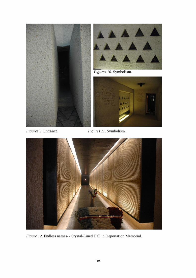
19
Figures 10. Symbolism.
Figures 9. Entrance. Figures 11. Symbolism.
Figure 12. Endless names-- Crystal-Lined Hall in Deportation Memorial.

20
3. 9/11 Memorial Park
New York, the United States
Designer: Michael Arad, Peter Walker and Partners, Davis Brody Bond, Snøhetta.
Year: 2004
Background:
The National September 11 Memorial was built to memorialize and honor the nearly three
thousand men, women, and children who died in the horrific attacks of September 11,
2001. (See Figure 13)
Figure 13. Eight-acre Memorial quadrant (Rendering by Squared Design Lab).
Most important features in this design:
Site Selection: Original Site – New York
Physical Environment Elements:
Space form: Square
Landform: Descending. The landscape descends into the memorial, which retains the
footprints of the World Trade Center.
Water Feature: Two very large memorial pools are where the Twin Tower used to be. Huge
waterfalls tumble down their sides, evoking vivid memories of the attacked buildings and
of the nearly 3,000 individuals who were killed in the September 11 attacks in New York

21
City.
Plants: Groves of trees that represent life and regeneration evoke life with living forms,
and will create a contemplative space separate from the sights and sounds of the
surrounding city.
Sensory Stimulants:
Light/Shadow: Light represents a bright future. In this design, ―Inversion of Light‖ as a
living memorial represents world peace. It means that future generations should remember
this great tragedy in order to pursue a peaceful life in the future.
Sound: The sound of the waterfall will block the noise of outside traffic and help people to
release their pressure and negative feelings.
Color: Black, representing grief, sacredness, coldness, fear. Blue represents peace and
helps people healing from the pain. Green represents life and hope.
Tactile: By touching the waterfalls, people can feel the reconnection between life and
death.
Sight: Nearly 400 trees create a contemplative space separate from the sights and sounds
of the surrounding city.
Psychological Elements:
All the elements above evoke people‘s emotions of fear, grief, sacredness, hope, and
peace.
Figure 11 retrieved August 16, 2009, from
http://trendsblog.co.uk/?cat=17

22
4. USS Arizona Memorial (USAR)
2 miles west of the Honolulu Airport in Pearl Harbor on the island of Oahu
Designer: Mr. Alfred Preis of Johnson, Perkins, and Preis of Honolulu.
Year: 1960
Background:
On December 7, 1941, the sunken battleship USS Arizona, was bombed by the Japanese
torpedo planes, and the USS
Arizona Memorial (USAR)
was built over the remains of
the ship to remember and
honor the 1,177 crewmen were
killed in this battle.
(See Figure 14)
Figure 14. USS Arizona Memorial.
Most important features in this design:
Site Selection: Original Site – where the event happened
Physical Environment Elements:
Form: Bridge
Manmade Constructions: The new memorial structure would span the original wreck of
the USS Arizona.
Sensory Stimulants:
Sound: The memorial is surrounded by water, so visitors can have a submerged sense of
floating while listening to the sound of the sea lapping against the boat.
Color: White, representing sacredness, peacefulness.
Sight: The design featured a submerged viewing area where visitors could view the sunken
ship through portholes.

23
Psychological Elements:
All the elements above evoke people‘s emotions of honor, courage, and tragic humanity.
Figure 14 retrieved August 16, 2009, from
http://www.arizonamemorial.org/locations/arizona-memorial-location.html

24
5. Nanjing Massacre Memorial Hall (China)
Nanjing, China
Year: 1985
Background:
The Memorial Hall is built to
commemorate 300,000 people who
were brutally slaughtered by Japanese
army (1937-1938). (See Figure 15)
Figure 15. Nanjing Massacre Memorial Hall
Most important features in this design:
Site Selection: Original Site –where
countless human bones of the victims of
the massacre were excavated
Physical Environment Elements:
Space Form: Combination of Square,
Triangle, and Rectangle
Landform: Half underground Figure 16. Exhibition hall.
Water Feature:
Combining reflection ponds, which
serve as a tribute to the spirits of the
victims, with sculptures will create a
sacred, peaceful, and serene place for
contemplation, healing, and
remembrance. (See Figures 16, 17) Figure 17. Sculptures.

25
Manmade Constructions:
Outdoor exhibits: The outdoor exhibit includes statues, sculptures, relief carvings, tablets,
and a large wall listing the names of victims, as well as an atonement tablet and a
memorial walkway. The memorial walkway displays footprints of survivors.
Exhibition hall: The tomb-like exhibition hall, half-underground, contains a large number
of historical documents and records related to the massacre. (See Figure 16)
Sensory stimulants:
Water: Reflection ponds serve as a place for personal contemplation to reflect on the
spirits of the victims.
Color: Gray, representing fear,
sacredness, and grief. Gray
cobblestones represent countless
bones.
(See Figure 18)
Figure 18. Nanjing Massacre Memorial
Tactile: When people touch the water, they will feel the reconnection between present and
past.
Sight: Sculptures were well organized as several focal points.
Psychological Elements:
All the elements above evoke a feeling of grief, hatred, unforgettableness, and
contemplation.
Figures 15-18 retrieved August 16, 2009, from
http://www.panoramio.com/photo/8515082

26
6. Berlin Holocaust Memorial
Berlin
Designer: Peter Eisenman
Year: 1999
Background:
The Holocaust Memorial commemorates nearly six million Jews murdered by Hitler and
his forces during World War II. (See Figure 19)
Figure 19. Berlin Holocaust Memorial by Peter Eisenman.
Most important features in this design:
Site Selection: Capital City – Berlin
Physical Environment Elements:
Space Form: Rectangle
Landform: Wave-like pattern. The gray concrete slabs undulate in a wave-like pattern.
Each one is a five-sided column, individually unique in shape and size. Some are only
ankle high while others tower over visitors. The paths that are shaped between the slabs
undulate as well.

27
Manmade Constructions: The Berlin Holocaust Memorial is made up of 2,711 gray stone
slabs that bear no markings, such as names or dates. Each slab can be seen as an individual
monument.
Sensory stimulants:
Light/Shadow: Walking through the shadow of slabs is just like walking through many
graves; people will feel scared and disoriented.
Color: Gray, representing fear, the sacred, and confusion.
Sight: The view through parallel slabs is limited, which makes people feel depressed and
confused.
Psychological Elements:
All the elements above evoke a feeling of groundlessness and instability—a sense of
disorientation.
Figure 13-16 retrieved August 16, 2009, from
http://architecture.about.com/od/greatbuildings/ig/Monuments-and-Memorials/Berlin-Hol
ocaust-Memorial.htm

28
Natural Disaster Memorials:
Earthquake (See Figure 20)
– Kobe Port Earthquake Memorial (Japan)
– Smriti Van Earthquake Memorial (India)
– Taiwan Chi-Chi Earthquake Memorial (Taiwan) Figure 20. Earthquake.
– Tangshan Earthquake Memorial Park (China)
Tsunami (See Figure 21)
– Tsunami Memorial in Khao Lak – (Lamru
National Park, Thailand)
Typhoon/Hurricane (See Figure 22) Figure 21. Tsunami.
– Hurricane Katrina Memorial
– The Florida Keys Memorial
Flood (See Figure 23)
– Wuhan 1954 Flood Memorial (Wuhan, China)
– 1937 Flood Memorial (Paducah, Kentucky)
Fire (See Figure 24) Figure 22. Typhoon/ Hurricane.
– Chicago Fire Memorial ---Unidentified
victims of the 1871 Chicago fire
Figure 23. Flood.
Figure 24. Fire.

29
1. Kobe Port Earthquake Memorial Park
Kobe, Japan
Year: 1995
Background:
The Port of Kobe Earthquake Memorial Park is a
natural disaster memorial park that was designed
to memorialize the great disasters caused by the
Hanshin Awaji Earthquake on January 17, 1995.
(See Figure 25)
Figure 25. Kobe Port Earthquake
Memorial Park.
Most important features in this design:
Site Selection: Original Site—Port of Kobe
Physical Environment Elements:
Space Form: Combination of Square, Triangle, and Rectangle.
Landform: Flat
Ruins: The collapsed pier and tilted street lamps are preserved as they were at the time of
the aftermath of the earthquake, so that visitors can witness the intensity of the tremor.
(See Figures 24, 25)
Manmade Constructions: Near the park is an exhibition space that displays photo panels of
the earthquake and other materials related to the earthquake damage.
(See Figures 26, 27, 28)
Sensory Stimulants:
Light/Shadow: Walking through the shadow of slabs is just like walking through many
graves; people will feel scared and disoriented.
Color: Gray and black granite walls, representing strength, sacredness, and silence.
Tactile: By touching the broken streets, people can easily get a strong feeling about the

30
damage resulting from the earthquake.
Sight: Important views toward the ruin were kept as the focal points through the whole site,
as they can evoke people‘s strong emotions about the earthquake; simultaneously, the
views can serve an educational function.
Psychological Elements:
All the elements above evoke a feeling of shock, fear, grief, and contemplation.
(See Figures 31, 32)
Figure 26. Kobe Port Earthquake Memorial Park. Figure 27. K.P.E.M. Park
Figure 28. K.P.E.M. Park. Figure 29. K.P.E.M. Park. Figure 30. K.P.E.M. Park.

31
Figure 31. Kobe Port Earthquake Memorial Park.
Figure 32. Kobe Port Earthquake Memorial Park.
Figure 25 retrieved August 17, 2009, from
http://www.gstraveladvice.com/index.php?location=294
Figure 26-32 retrieved August 17, 2009, from
http://commons.wikimedia.org/wiki/Category:Port_of_Kobe_Earthquake_Memorial_Park

32
2. Smriti Van Earthquake Memorial
India
Designer: Rajeev Kathpalia
Year: 2004
Background:
This is a project in western India that commemorates victims of the 2001 earthquake that
took nearly 14,000 lives. The poetic quality of Rajeev Kathpalia‘s project lies not so much
in the individual details, architectural or landscaping, but in the ―remembrance of loss
through a process of nature‘s constant regeneration.‖23
Most important features in this design:
Site Selection: Original Site
Physical Environment Elements:
Space Form: Hemicycle
Landform: Convex, hilly, earthquake-prone area
Water Feature: 108 reservoirs would be arranged in the landscape for providing a safe
supply of drinking water to the citizens during the earthquake. (See Figure 33)
Plants: The planners designed the park to show life as impermanent, but also sacred.
Precisely 13,805 trees representing 13,805 victims will be planted and will grow ―without
dependence on extraneous energy sources.‖23
Manmade Constructions: Reservoirs — museum buildings, a reception plaza, a viewing
promenade, and parking facilities. (See Figure 34)
23
B. Brian Taylor, ―Water‘s Healing Power.‖ Architectural Digest 63, no.10 (2006, October):1-3.

33
Sensory Stimulants:
Color: Blue and green, represent
regeneration
Sight: Important views toward the ruin
were kept as the focal points throughout
the site, as they can evoke people‘s strong
emotions about the earthquake; at the
same time, the views serve an educational
function.
Figure 33. Smriti Van Earthquake Memorial.
Psychological Elements:
All the elements above evoke a feeling of
awe, respect and appreciation of nature
while remembering and honoring those
who died.
Figure 34. Smriti Van Earthquake Memorial.
Figures 33-34 retrieved August 17, 2009, from
http://www.worldarchitecture.org/world-buildings/world-buildings-detail.asp?position=det
ail&country=India&no=2925

34
3. Taiwan Chi-Chi Earthquake Memorial
Taiwan
Designer: Liu Yuyang, Haewon Shin, Tynnon Chow, Larry Tsoi, Yvonne Lo, Gigi Wong,
Ronan Collins
Year: 1999
Background:
The memorial was built to remember the victims and survivors of the Chi-Chi earthquake
in Taiwan on September 21, 1999. Two thousand, four-hundred thirty-seven people were
killed, nearly 11,305 people were injured, and more than 107,002 houses were collapse.24
Design:
The Project drew inspiration from both the visible and the invisible remains of the
earthquake: the plateaus of ruins, the retaining walls, the fault line beneath, and the
resilient trees. (See Figures 35, 36)
The design comes through the articulation of three elements—ground, canopy, and
campus—out of which a new performance center and urban strategies are evolved.
Figure 35. Taiwan Chi-Chi Earthquake Memorial.
24
Y. Li and Y. Yang, ―The Research on Functional Adaptation of Campus as a Shelter after Earthquake.‖
Urbanism and Architecture 3 (2009): 1-23.

35
Figure 36. Taiwan Chi-Chi Earthquake Memorial.
Figures 33-34 retrieved August 17, 2009, from
http://www.alya.cn/CCEMC.html

36
4. Tangshan Earthquake Memorial Park
Tangshan, China
Designer: Latz + Partner Landschaftsarchi Tekten Planner
Year: 2008
Background:
On July 28, 1976, a severe earthquake measuring 7.8 on the Richter scale took place in
Tangshan and 240,000 lives were lost. It was one of the 10 most severe natural disasters in
the 20th century. (See Figures 37, 38)
Figure 37. Ruins after Tangshan quake. Figure 38. Railroad.
Most important features in this design:
Site Selection: Original Site
Physical Environment Elements:
Space Form: Square and Triangle
Landform: Flat
Water Feature: Reflection Ponds.
Plants: Aspens, which represent the brave and noble spirit, were planted parallel to the
memorial walls in order to strengthen the principal axis.
Ruins: The existing earthquake site and surrounding areas were preserved as much as
possible.
Manmade Constructions:

37
Memorial Path: The path of Memories was introduced, which separated the existing paths
into four parts, and all the four parts were connected by the design concept ―Memorizing‖
in the earthquake site. (See Figures 39, 40)
Memorial Wall: The 400m-long black-granite Memorial Wall with all victims‘ name
evokes a strong feeling of sadness and memory of victims who lost their lives in the
earthquake. (See Figure 42)
Sensory stimulants:
Water: Combining reflection ponds, which serve as a tribute to the spirits of the victims,
with debris will create a sacred, peaceful, and serene place for contemplation, healing, and
remembrance. (See Figure 41)
Sound: Aspens were planted along the memorial walls, allowing the wind to blow across
the trees, creating a murmuring sound that emphasizes the sorrowful atmosphere.
Color: Black walls and gray paths represent sacredness, grief, and peace. Green represents
new life and hope.
Tactile: The reflecting pool and tree islands work together, creating sensory elements that
evoke psychological emotions through the use of water as a physical barrier to the tree,
which represents life.
Sight: Important views toward the ruin were kept as the focal points throughout the site, as
they can evoke people‘s strong emotions about the earthquake.
Psychological Elements:
All the elements above evoke a feeling of sympathy for the earthquake victims and
admiration for the survivors.

38
Figure 39. Tangshan Earthquake Memorial Park.
Figure 40. Tangshan Earthquake Memorial Park.

39
Figure 41. the Ruins. Figure 42. 300-meter Memorial Walls
(with 240,000 names).
Figure 43. Tangshan Earthquake Figure 44. Educational Display.
Memorial Hall.
Figure 45. Ceremony.
40
Figures 37-38 retrieved September 17, 2009, from
Chen, Deshang. ―Field Phenomena in Meizoseismal Area of the 1976 Tangshan
Earthquake.‖ in: The 1976 Tangshan, China Earthquake: papers presented at the 2nd U.S.
National Conference on Earthquake Engineering [Stanford, 1979]. Berkeley: EERI, 1980.
Figures 39-40 retrieved September 17, 2009, from
http://www.chla.com.cn/html/c179/2008-11/22625.html
Figures 41-45 retrieved September 17, 2009, from
http://bbs.tiexue.net/post_3549089_1.html

41
5. Tsunami Memorial in Khao Lak (Mountains of Remembrance)
Khao Lak – Lamru National Park, Thailand
Designer: Naga Concepts and Disc-O Architecture
Year: 2006
Background:
The goal of this design was to
create a memorial site to honor the
great spirit and courage of people,
who have fought for their lives, and
the lives of others, during and in
the aftermath of the Tsunami on
December 26th, 2004.
(See Figure 46)
Figure 46. Tsunami Memorial in Khao Lak.
Most important features in this design:
Location-- Original Site
Memorial & Education & Disaster Prevention: The memorial allows visitors to
commemorate and be educated about the causes and effects of a tsunami. It includes areas
of contemplation, a museum, a library, a learning center, an amphitheater, lecture halls,
conference rooms, and restaurants.
Low Impact Design: Sensitivity to nature

42
Five-mountain form – represents the power and forces of tsunami that ended so many
lives during the disaster, which not only makes people remember this tragic event, but also
helps them to understand the cause of the disaster by evoking their sense of the power of
natural disasters, and giving a feeling of urgency about preventing it in the future.25
(See Figure 47)
Figure 47. Tsunami Memorial in Khao Lak.
Figures 46-47 retrieved September 19, 2009, from
http://www.inhabitat.com/2006/06/18/tsunami-memorial-winner-mountains-of-remembera
nce/
25
―Tsunami Memorial Winner: Mountains of Remembrance,‖ Tsunami Memorial Design Competition, 2006,
http://inhabitat.com/2006/06/18/tsunami-memorial-winner-mountains-of-rememberance (accessed June 11,
2010).

43
6. St. Bernard Hurricane Katrina memorial
St. Bernard Parish, Louisiana, U.S.
Year: 2006
Background:
St. Bernard Parish put up a memorial to honor 129
parish residents who died in Hurricane Katrina in
2005, along with a 13-foot-tall cross bearing the
likeness of the face of Jesus.
(See Figures 48, 49)
Most important features in this design: Figures 48, 49. Hurricane Katrina.
Location-- Original Site
A cross stands out in the water: Evokes the emotions of loneliness, remembrance and
sadness, which also represents the distance between life and death.
Memorial Wall—with the names of victims: Black reflective marble.
Figure 50. Daytime. Figure 51. Nighttime.
Figure 52. Prayers.

44
Figure 53. Memorial Wall.
Figure 54. Memorial Wall.
Figures 50 retrieved September 19, 2009, from
http://www.patricksemansky.com/updates5.html
Figures 51 retrieved September 19, 2009, from
http://www.nola.com/news/index.ssf/2008/02/photos_for_katrina_memorial_st.html
Figures 53 retrieved September 19, 2009, from
http://www.nola.com/news/index.ssf/2008/10/photo_katrina_memorial_rededic.html
Figures 54 retrieved September 19, 2009, from
http://quintascott.files.wordpress.com/2009/07/mrgokatrinamemorial.jpg

45
7. The Florida Keys Memorial (Hurricane Monument)
Islamorada, Florida
Designer: Artists of the Miami Federal Art Project
Year: 1937
Background:
This memorial is dedicated to the victims of
the 1935 hurricane that devastated the
Florida Keys and took 435 lives.
(See Figure 55)
Most important features in this design:
Location: Original Site
Monument: Bas-relief pattern: depicts palm
trees and ocean waves that were being blown
by a hurricane. Figure 55. Relief Art Sculptures.
Paving: The flooring is covered with keystone, or coquina, slabs. In the center of the
flooring is a crypt. (See Figure 57)
Tile map: The top of the crypt is covered with a 22-foot-long tile map depicting the
Florida Keys from Key Largo to Marathon. (See Figure 58)
Figure 56. Bronze Plaque. Figure 57. The Florida Keys Memorial.

46
Figure 58. Crypt is covered with a map of the upper Keys.
Figures 48-49 retrieved September 19, 2009, from
http://mozey.wordpress.com/2007/12/05/are-these-rare-photos-of-hurricane-katrina-or-bog
us/
Figures 50-51 retrieved September 19, 2009, from
http://www.nola.com/news/index.ssf/2008/02/photos_for_katrina_memorial_st.html
Figures 53-54 retrieved September 19, 2009, from
http://www.nola.com/news/index.ssf/2008/10/photo_katrina_memorial_rededic.html
Figure 55 retrieved September 19, 2009, from
http://www.wunderground.com/blog/ThunderBev/comment.html?entrynum=102
Figures 56-58 retrieved September 19, 2009, from
http://www.semp.us/publications/biot_reader.php?BiotID=631

47
8. Wuhan 1954 Flood Memorial
Wuhan, China
Year: 1969
Background:
This memorial was built to memorialize those 33,000 lives that ended as a result of the
great flood in Wuhan, China, 1954.
Design:
The main part of the memorial is a monument with Mao Zedong's head sculpture, and his
famous poem ―Swimming‖ (1956), which represents people‘s belief and their courage in
fighting the flood. (See Figures 59, 60)
Relief displaying people fighting the flood, with the slogan, ―一不怕苦,二不怕死‖ (First,
don't fear hardships; second, don't fear death).
Figure 59. Wuhan 1954 Flood Memorial.

48
Figure 60. Wuhan 1954 Flood Memorial.
Figures 59-60 retrieved September 24, 2009, from
http://commons.wikimedia.org/wiki/File:Wuhan-Flood-Memorial-0226.jpg

49
10. Chicago Fire Memorial
Chicago, United States
Designer: Egon Weiner
Year: 1971
Background:
Hundreds of people were killed and about four
square miles were badly destroyed by the
Great Chicago Fire on October 10, 1871.26
(See Figure 61)
Figure 61. Aftermath of the fire,
corner of Dearborn Monroe Streets,
1871.
Most important features in this design:
Location-- Original Site: The corner of DeKoven and Jefferson, in the Near West Side
Neighborhood, is the legendary site of the start of the Chicago Fire of 1871.
Memorial -- Chicago Fire Memorial: The sculpture is on the site of the fire, with the
Chicago Fire Academy in the background. (See Figures 62, 63)
Municipal Flag of Chicago: On the municipal flag of Chicago, the second star
commemorates the fire. To this day, the exact cause and origin of the fire remain a mystery.
(See Figure 64)
Sculpture: Chicago Firefighters Memorial (Chicago). (See Figures 64, 65)
Figures 62, 63. Chicago Fire Memorial. Figure 64. Municipal Flag of Chicago.
26
F. Richard Bales, ―Did the Cow Do It? A New Look at the Cause of the Great Chicago Fire,‖
(2004), .http://www.thechicagofire.com (January 14, 2010).

50
Figure 65. A marker commemorating the fire
outside the Chicago Fire Academy.
Figures 66, 67. Chicago Firefighters Memorial (Chicago).
Figures 61 retrieved September 24, 2009, from
http://www.thunderbolts.info/tpod/2006/arch06/060209chicagofire.htm
Figures 62- 65 retrieved September 24, 2009, from
http://dailychicagophoto.blogspot.com/2009/11/chicago-fire-memorial.html
Figures 66-67 Retrieved September 24, 2009, from
http://www.flickr.com/photos/farmdog/3350193554/

51
Natural Disaster Prevention Parks:
1. Osu Disaster Prevention Park:
Ichikawa, Japan
Year: 2002-Present
Background:
Many cities in Japan started to plan and build disaster
prevention parks, such as Miki Earthquake Disaster
Memorial Park (Miki City, Hyogo) and Osu Disaster
Prevention Park (Ichikawa, Japan), as well as others.
(See Figures 68, 69)
Figures 68, 69. Japan Hanshin
Awaji earthquake, 1995.
Most important features in this design:
The park functions, in the case of emergencies/disaster occurrences, as a temporary site
for refugees and rescue/aid activities, as well as a recreational site during times when there
is no disaster.
Figure 70. Osu Disaster Prevention Park. Figure 71. Osu Disaster Prevention Park.

52
Figure 72. Osu Disaster Prevention Park.
Figure 73. Disaster Prevention Facilities Management.

53
Figure 74. Master Plan and Emergency Escape Information.
Figures 68 retrieved September 24, 2009, from
http://nisee.berkeley.edu/elibrary/Image/B2849
Figures 69 retrieved September 24, 2009, from
http://www.britannica.com/EBchecked/topic/873249/Kobe-earthquake-of-1995
Figures 70-74 retrieved September 24, 2009, from
http://blogs.yahoo.co.jp/ttn4euw27n/20765761.html

54
2. Wuhan Riverside Park & Flood bank (Wuhan, China)
Wuhan, China
Year: 2002-Now
Background:
The Wuhan Riverside Park integrates
flood control, scenery, tourism, leisure
and sports into a whole.
(See Figure 75)
Figure 75. Wuhan Riverside Park.
Most important features in this design:
Flood Control: The Park can be used as flood bank, which can prevent flooding.
Scenery and Tourism: There is a vast piece of ―green‖ at the riverside: alleys, bamboo
forest, rockwork, fountain and sculptures, and benches for tourists to take a rest and
sightsee. (See Figure 76)
Leisure and Sport: There are a complete set of entertainment facilities and a leisure belt
stretching into the far distance together with the flowing water. It is the best place for
people to exercise during the morning and night.
Memorial: There are many sculptures telling stories about the history of the city and flood.
Lighting: At night, the brilliant light and breeze make people feel reluctant to leave.
(See Figures 76, 78)

55
Figure 76. Wuhan Riverside Park.
Figure 77. Wuhan Riverside Park.
Figure 78. Wuhan Riverside Park.
Figure 75 retrieved September 24, 2009, from
http://lvyou.xooob.com/tslysj/20095/379701.htm
Figures 76-78 retrieved September 24, 2009, from
http://www.lvyou114.com/tuku/Photofull.asp?Photoid=3908
http://www.cts2008.com/Member/Sight/nnhnn/

56
Other Memorials:
1. Martin Luther King Memorial Park in
Washington, DC
Washington D.C., the United States
Designer: ROMA Design Group
Year: 1971
Figure 79. Martin Luther King
Memorial Park.
Background:
The Martin Luther King, Jr. National Memorial in Washington, DC was built to honor Dr.
King‘s dedication to freedom, opportunity, and justice. (See Figure 79)
Most important features in this design:
Location: Capital City
Memorial Gate: ―Mountain of Despair‖
Memorial Wall: A semi-circular water wall inscribed with King‘s quotes. On the back
side of the wall of quotes lie 24 niches along the upper walkway, some commemorating
individuals who gave their lives during the civil
rights movement, and some remaining unfinished
and undedicated, out of ―deference to the
unfinished nature of the movement,‖ representing
the unfinished fight against racism, inequality,
and injustice.27
(See Figures 80, 81, 82, 83)
Figure 80. ―Stone of Hope‖.
27
Joshua F.J. Inwood, ―Contested Memory in the Birthplace of a King: A Case Study of Auburn Avenue and
the Martin Luther King Jr. National Park.‖ Cultural Geographies, January 16 (2009): 87-109.

57
Monument: ―Stone of Hope,‖ featuring a partial sculpture of King overlooking the Tidal
Basin, lies at the heart of the memorial. (See Figure 80)
Reflection Pond: The pond evokes the sense of freedom and peace.
Figures 81. A model of the Figures 82. A model of the
Martin Luther King, Jr. National Martin Luther King, Jr. National
Memorial. Memorial.
Figures 83. A model of the Martin Luther King, Jr. National Memorial.
Figures 79-83 retrieved September 24, 2009, from
http://www.masslive.com/news/index.ssf/2010/01/western_mass_communities_plan.html

58
2. The Washington Monument
Washington D.C., the Unites States
Designer: Robert Mills
Year: 1884
Background:
The Washington Monument was built to commemorate the first U.S. president, General
George Washington. It was the world's tallest structure when it was completed in
Washington D.C. in 1884. (See Figure 84)
Most important features in this design:
Location: Capital City
Shape: A simple tapered obelisk. The
pyramid shape of the monument was
inspired by ancient Egyptian architecture.
Landform: Flat
Monument Material: It was made of white
marble, granite, and sandstone.
Reflection Pond and Monument: These
elements evoke the contrasting senses of
Peace and Force, Horizontal and Vertical,
Smooth and Sharp.
Figure 84. The Washington
Monument in Washington D.C.
Figures 84 retrieved September 24, 2009, from
http://crapo.senate.gov/idaho/fast_facts/cherry_blossom.cfm

59
3. Church on the Water
Hokkaido, Japan
Designer: Tadao Ando
Year: 1985-1988
Background:
In the northern Japanese island of Hokkaido there is a church on the water located in
Tomamu. It's a spot where the slope is facing toward a small river.28
(See Figures 85, 86)
Most important features in this design:
In this project, Ando succeeds in defining sacred space in several ways:
A glass and steel cube: directs the view upwards.
A long, L-shaped wall: demarcates the church as a protected, secluded area.
The underground entry path: It is ―intentionally circuitous, a sense of ritual and
purification results, similar to the sufferings and revelations that define the religious
experience‖ (He, 2009).
The Reflection Pond with a steel cross placed in the middle of it, evokes a sense of peace,
contemplation, and the sacred.
Figure 85. Church on the Water. Figure 86. Church on the Water.
Figures 85-86 retrieved September 24, 2009, from
http://www.royalacademy.org.uk/events/talks/tadao-ando-hon-ra,299,EV.html
http://www.arcspace.com/exhibitions/Ando_Ex1/Ando_Exhibition.html
28
Yunzhu He, ―Creation of the Holy Space — An Analysis Of Tadao Ando's ‗Church On The Water‘.‖
Architecture & Culture 1, (2009): 5-20.

60
4. Church of the Light
Ibaraki, Osaka, Japan
Designer: Tadao Ando
Year: 1989
Background:
Church of the Light, also known as ―Church with
Light,‖ was built in 1989, and it is the Ibaraki
Kasugaoka Church‘s main chapel. (See Figure 87) Figure 87. Interior Space.
Most important features in this design:
The lighting is an important controlling factor. The open space is defined by light, by the
physically powerful contrast between light and solid. Looking in from the front toward the
cross, light grows from behind the altar from a cross cut in the concrete wall that extends
vertically from floor to ceiling and horizontally from end to end, lining up perfectly with
the joints in the concrete. The interior design is meant to be open space of emptiness to
transfer someone into the realm of the spiritual. The discrete void space and quietness
evoke a sense of peacefulness. Enclosed spaces inside were build by means of thick
concrete walls. (See Figures 88, 89, 90)
Figures 88. Interior space Figures 88. Interior space Figures 88. Interior space
of the church. of the church. of the church.
Figures 87-90 retrieved September 24, 2009, from
http://figure-ground.com/church_light/

61
5. Qijiang Park in Zhongshan City (Zhongshan Shipyard Park)
Zhongshan, Guangdong, China
Designer: Kongjian, Yu
Year: 2001
Background:
This park was built upon an old shipyard and a brown field. The design explains itself in
terms of how landscape architects can turn a wrecked site into a beautiful, meaningful, and
functional place, as well as in terms of the important role landscape architects can play in
urban renovation. Many workshops and machines were conserved, including gantry cranes,
railways, transformers, and so forth.
(See Figures 91, 92, 93)
Most important features in this design:
1. The designer kept the natural weeds in the site because he believed that the beauty of
weeds represents neglected, ordinary, natural beauty. He explained, ―Weed itself is wild
and chaotic, but after design and by appreciation of people, the designed weed looks
beautiful.‖29
2. Through the design of the waterfront trestle bridge, the spring and pane style, and
hedges, the project offers people the chance to recognize a natural approach to water and
exploring unseen space.
29
Yu Kongjian, ―The Culture that Has Been Ignored, the Beauty of Weeds -- Qijiang Park in Zhongshan
City.‖ New Architecture May (2001).

62
Figure 91. Qijiang Park in Zhongshan City.
Figure 92. The Red Box, telling the Figure 93. The rust rails reused, and
story of the Cultural Revolution and became central access to the park,
socialist China in previous decades. along with wild native grasses.

63
3. Relationship to the urban context
Many urban facilities and functions were involved in the design. For example, they
transformed docks into teahouses in order to make better use of the industrial remnants.
Derelict industrial sites transformed into public areas can improve the quality of life and
land use, as well as representing a transformation of old industrial sites to new cultural and
environmental uses.30
4. Environmental responsibility
Many natural and man-made
materials used in this project were
reducible and recyclable. Native
plants and habitats were preserved
and widely used in the park.
This park has become an
environmental, educational,
cultural, and historical site for the
local people.
Figure 94. MasterPlan, Zhongshan Shipyard Park.
Figures 91-94 retrieved September 24, 2009, from
http://www.landscape.cn/paper/sjg/2009/034401.html
30
L. Loures and T. Panagopoulos, ―Sustainable Reclamation of Industrial Areas in Urban Landscapes.‖ WIT
Transactions on Ecology and the Environment 102 (2007): 1-4.

64
6. Nanjing Dr. Sun yat-sen's Mausoleum
Nanjing, China
Designer: Lu Yanzhi
Year: 1929
Background:
Dr. Sun Yat-sen‘s Mausoleum (中山陵) was built to honor Dr. Sun, the ―Father of Modern
China,‖ who fought against the imperial Qing government and founded the Republic of
China in 1911. It is located at the Mount Zijin (Purple Mountain) in Nanjing, China .31
(See Figure 95)
Most important features in this design:
Lying at the mountainside, the vault is more than 700 hundred meters away from the
entrance, which is a long path (―Tao‖) visitors must travel before reaching the end. To
traverse this path is like experiencing the entire life of the great hero, which evokes a
sense of respect, honor, and courage.
Location: Sun Yat-sen‘s burial place
Landform--Ascending: The landscape ascends up to the memorial. (See Figure 94)
Style: Reclining on a mountain slope, the majestic mausoleum blends the styles of
traditional imperial tombs and modern architecture.
Paifang: Traditional Chinese construction as the entrance of the mausoleum.
A three-tier stone: A stand on which a huge bronze ding, an ancient Chinese vessel
symbolizing power, perches.
31
D. Charles Musgrove, ―Monumentality in Nanjing‘s Sun Yat-sen Memorial Park.‖ Southeast Review of
Asian Studies 29 (2007): 1–19.

65
Stairway: The 480-meter-long and 50-meter-wide stairway has 392 stairs leading to the
vault. On both sides, pine, cypress, and ginkgo trees guard the way.
Entrance Gate: The tri-arched marble gate with Dr. Sun‘s four words, ―Tian Xia Wei
Gong,‖ which means power should belong to the people, represents his belief and goal for
his entire life. (See Figure 95)
Sacrificial hall
Bell-shaped vault: wherein lies the sarcophagus of Dr. Sun
Memorial monument
Figure 95. Entrance Gate. Figure 96. Nanjing Dr. Sun yat-sen's
Mausoleum.
Figure 97. Entrance Gate.
Figures 95-97 retrieved September 24, 2009, from
http://www.absolutechinatours.com/china-tours/SHEC-27/

66
2.5 The Comparison Chart of W.M.P. and N.D.M.P.
The following is a summary of the comparison of War Memorial Park design (W.M.P.)
and Natural Disaster Memorial Park design (N.D.M.P.) from the case study.
(See Figure 98)
W.M.P. N.D.M.P.
Role A memorial for the victims of
warfare
A memorial for the
victims of natural
disasters
Site Selection Central/Capital City- an
important emblem of political,
power and ideology during and
after war
Original Site- the place
where the historical
event/disaster happened
Physical
Environment
Elements
Space Form: Triangle, Square,
Rectangle, Combination of the
three (Sharp and enclosure)
Landform: Descending into the
ground
Water Feature:
Running waterfall/ fountain
Plants: Plants were not widely
used.
Grass: Open lawn
Ruins: Ruins/ battle fields were
hard to trace and preserve
Space Form: Square,
Rectangle, Hemicycle
Landform: Flat
/Ascending up to the
ground
Water Feature: Reflection
Pool with bronze
sculpture or debris ,
Running water
Plants: Evergreen tree &
Local Plants & Special
meanings:
Pine-regeneration;
Aspen-sorrow, brave;
Bamboo- peace, moral
integrity, solidarity, hope
Grass: Open tree lawn
Ruins: Preserve the
important ruins. Some
ruins/debris can be used
as special design elements

67
Manmade Constructions:
Memorial wall/ monument,
museum, memorial path,
memorial square, Parking lot
Manmade Constructions:
Museum, memorial path,
memorial
wall/monument,
memorial square, disaster
education center, Parking
lot
Sensory
Stimulants:
Water: Reflection water evokes
senses of peace, contemplation,
and sacredness; Running water
combined with Sculptures or
display walls can provide an
active space and give visitors
release from sorrow.
Light/Shadow: dark and gloomy
Sound:
The sound of water will block the
noise of outside traffic and help
people to release their pressure
and negative feelings.
Color: Black, White, Grey, Green
White represents honor, the
sacred and peace. Black
represents grief, sacredness,
coldness, and fear. Blue
represents peace and helps people
heal from the pain. Gray
represents coldness, fear, and
gloom.
Tactile: Using rough materials to
create an uncomfortable sense.
By touching the rough concrete
walls, people can feel the dark
period during the war.
Water: Reflection water
evokes senses of peace,
contemplation, and the
sacred; Running water
combined with sculptures
or display walls can
provide an active space
and give visitors release
from sorrow.
Light/Shadow: dark,
gloomy, and then bright.
Sound:
The sound of water will
block the noise of outside
traffic and help people to
release their pressure and
negative feelings.
Color: White represents
honor, sacredness and
peace. Black represents
grief, sacredness,
coldness, fear. Blue
represents peace and
helps people heal from
the pain. Green represents
life and hope,
regeneration
Tactile: Rough materials
can remind people about
tragedy and the ruins.
However, reflective
material can create a
contemplative and
healing place. By
touching the water,
people can feel the
reconnection between life
and death.

68
Sight: Views always have been
limited within an enclosure, a
narrow and gloomy space, which
evokes strong senses of fear and
depression.
Sight: Important views
toward the ruin should be
kept as the focal points.
Psychological
Elements:
Winner: Victory, heroism, honor,
glory, remembrance, peace,
Loser: Shame, hatred, grief, fear,
the sacred, remembrance, peace,
freedom.
Grief, sympathy, fear, the
sacred, awe, respect,
remembrance, honor,
love, courage
Main Functions Memorial Wall/Monument (with
victims‘ names), Memorial
garden
Ruins, Memorial
Wall/Monument (with
victims‘ names),
Cemetery, Memorial
garden, Disaster
education, Disaster
prevention
Ceremony National Ceremony National/Local ceremony
Figure 98. Comparison Form of W.M.P and N.D.M.P.
2.6 Summary of the Case Study
From the comparison diagram, we can summarize the differences between and similarities
among W.M.P. and N. D.M.P. The key elements that can be applied to N.D.M.P. are listed
below:
1. Site Selection----- Original Site- the place where the historical event/disaster happened
2. Main Functional Areas----- Ruins, Memorial Wall/Monument, Cemetery, Memorial
garden, Disaster education, Disaster prevention
3. Physical Environment Elements:
Landform: Flat/Ascending up to the ground
Water Feature: Using Reflection water creates peaceful and healing atmosphere. Running

69
water combined with sculptures or display walls can provide an active space that can
attract more public participation and also can make visitors release their sorrow.
Plants: Evergreen tree & Local Plants & Special meanings: Pine-regeneration;
Aspen-sorrow, brave; Bamboo- peace, moral integrity, solidarity, hope.
Ruins: Preserve the important ruins. Some ruins/debris can be used as special design
elements.
Manmade Constructions: Museum, memorial path, memorial wall/monument, memorial
square, disaster education center
4. Sensory Stimulants:
Water: Reflection water evokes senses of peace, contemplation, and the sacred; Running
water combined with sculptures or display walls can provide an active space and give
visitors release from sorrow.
Light/Shadow: Dark, gloomy, and then bright.
Sound: The sound of water will block the noise of outside traffic and help people to
release their pressure and negative feelings.
Color: White represents honor, sacredness, and peace. Black represents grief, sacredness,
coldness, fear. Blue represents peace and helps people heal from pain. Green represents
life and hope, regeneration.
Tactile: Rough materials can remind people about tragedy and the ruins. However,
reflective material can create a contemplative and healing place. By touching the water,
people can feel the reconnection between life and death.
Sight: Important views toward the ruin should be kept as the focal points.
5. Psychological Elements:
Grief, sympathy, fear, the sacred, awe, respect, remembrance, honor, love, courage

70
Chapter Three
Methodology and Survey Results
3.1 Research & Methodology
An interview-based survey was distributed to obtain information on different people‘s
understanding of the earthquake and on their perceptions of the earthquake experience.
The objective of the survey was to ascertain whether people would identify the concepts
of the basic elements in memorial park design that were presented in the case study review.
The survey was distributed through different channels over the course of two weeks; out
of a possible 650 responses, 150 were received.
3.2 Procedure
Survey Instrument
The participants were introduced to the survey by a survey form (in both English and
Chinese), and the requirements for participation were explained to them. The survey
consisted of twelve questions that were a mix of open-ended, multiple choice, and scalar
questions designed to allow the participant to recall the earthquake experience and
describe or evaluate how the concepts of the memorial park design did or did not affect
that experience.
Participants
In order to make this survey more comprehensive, 650 participants were chosen from a
random sample that included both local people and some indirect participants from other
cities, such as Wuhan, Beijing, and Chengdu.

71
3.3 Results
The survey began with two multiple-choices questions, inviting the respondents to
answer some basic questions about themselves. The purpose of the two questions was
threefold: first, to set up a positive frame of mind for answering the survey; second, to see
the personality of participants; and third, to see their main purpose for visiting this site.
The results of the survey show that the tourists are over 50% (332) local people and that
officials make up 20% of the tourists; more than 30% of the interviewees are from the
other cities outside Wenchuan, and their main purpose in coming to this site is to visit and
remember. (See Figures 99, 100 for results.)
Question 1: What‘s your relationship to Wenchuan?
□ Local person □ Local official □ Tourist □ Other _________
Figure 99. The result of question 1.
Question 2: Why do you come here?
□ Visiting □ Studying □ Memorializing □ Other _________
Figure 100. The result of question 2.
The purpose of Question 3 was to ascertain how much interviewees know about
earthquake prevention. The answers show that nearly 64% of the interviewees have
participated in some earthquake prevention maneuvers held by schools or government or

72
had gained some related knowledge about earthquake prevention through other media,
such as TV and the Internet. However, 37% of the interviewees have never received
evacuation training or information about earthquake prevention. The results of this
question suggest that there should be more earthquake prevention or notice provided in the
future park design. (See Figure 101 for results.)
Question 3: Have you participated in any earthquake prevention maneuvers or have some
related knowledge about earthquake prevention?
□ Yes(where/which medium?)_________________
□ No
Figure 101. The result of question 3.
The purpose of Question 4 was to better understand how much the interviewees know
about earthquake prevention. The results of Question 4 show that most people chose an
open park or plaza as their first place to go when the disaster happened; some people also
chose to hide in the basement of earthquake prevention buildings. This data illustrates that
a public park will provide shelter and play a significant role in disaster reduction. (See
Figure 102 for results.)
Question 4: When the disaster happens, which place below would you consider as the best
one to go to?
□ Residential Park □ Public park/ plaza □ Earthquake prevention building, basement
□ Hospital □ Other

73
Figure 102. The result of question 4.
The results of Question 5 reaffirm the importance to local and nonlocal people of
building a public park to memorialize this tragedy. For the local people, building a
memorial park is very desirable in terms of attracting more visitors; the park may provide
their only means of financial support in the long run. For the visitors, building a memorial
park is necessary to memorialize those victims and become more familiar with the disaster.
(See Figure 103 for results.)
Question 5: How important is a public park to you in serving as a memorial of this tragedy?
(1 indicating little importance and 5 indicating the highest importance): 1, 2, 3, 4, 5
Figure 103. The result of question 5.
The purpose of Question 6 was to inquire as to where the interviewees think is the
best site for building the 5/12 earthquake memorial park. The results of Question 6 show
that 60% of the people asked chose Wenchuan because it is where the earthquake took
place; 20% of the respondents chose Beichuan because that is where many young students
are buried. Furthermore, 12% of people chose Yingxiu because it is the epicenter, which

74
has the most serious damage, and nearly 6% of the interviewees chose Beijing because
they think the capital has the most influence on the whole country, which can make us
attach importance to this big event. (See Figure 104 for results.)
Question 6: Which county do you think is the best site for building the 5/12 earthquake
memorial park?
□ Wenchuan □ Yingxiu □ Beichuan □ Beijing □ Other _________
Reason: _____________________________________________________________
Figure 104. The result of question 6.
The purpose of Question 7 was to see which place had the strongest impact on the
interviewees‘ experience. The results of Question 7 indicate that the most impressive place
in their mind was the altar built after the quake and earthquake landforms resulting from
the earthquake that can be found in the park, such as landslides, cracks, faults, and folds.
(See Figure 105 for results.)
Question 7: Where is the most impressive place in your mind?
□ Earthquake Landforms □ the Hypocenter of Niu Mian Gou □ Altar and Cemetery
□ Other _____ Reason: _____________________________________________________
Figure 105. The result of question 7.

75
Question 8 was an open-ended question, inviting the respondent to think about a
negative experience in the current memorial site, which was the ruins of the earthquake.
The answers to this question show that there were many deficiencies, such as a lack of an
obvious sign emergency exit sign and a disaster prevention place, insufficient fireproofing
facilities, and the inefficient nature of some functions of park.
The results of Question 9 suggest that disaster prevention and education are the most
important functions in the earthquake memorial park, while tourism, scientific research,
and recreation are considered the second most important functions. (See Figure 106 for
results.)
Question 9: What functions do you think the an earthquake memorial park should have?
□ Memorial □ Ecological □ Disaster prevention □ Education
□ Tourism □ Recreation □ Scientific research □ Other_______
Figure 106. The result of question 9.
The purpose of Question 10 was to see if participants would identify any of the design
elements of the natural disaster memorial park as contributing to their memorable
experience. The answers to this question suggest that public monuments and green grass
are the most important design elements, while the stone, water feature, and artwork are
considered the second most important elements. (See Figure 107 for results.)
Question 10: Please select the most important elements you would want to see in a
memorial park:

76
□ Green grass □ Water feature □ Stone
□ Artwork □ Public monuments □ Other __________
Figure 107. The result of question 10.
The purpose of Question 11 was to see how important the cultural elements will be in
the future design.
Question 11: Many aspects of cultural heritages were destroyed by the Wenchuan
earthquake, including those of the Aba Tibetan and the Qiang Autonomous Prefecture
heritage. What percentage of cultural elements do you think should be included in the
earthquake memorial park? (See Figure 108 for results.)
□ <10% □10%—20% □20%—30% □30%—40% □40%—50% □ >50%
Figure 108. The result of question 11.
The survey concluded with the open-ended Question 12, which invited the respondent
to think about memorable feelings and senses about the earthquake. Reports about these
feelings and senses were collected in order to deeply understand people‘s mentality

77
change and their attitudes toward this event. Based on the results, different spaces should
be created depending on different senses. (See Figure 109 for results.)
Figure 109. The result of question 12.
3.4 Discussion
From the data acquired through this survey, the following conclusion can be made:
●Participants identified that both local and nonlocal people feel that it‘s necessary to
build a public park to serve as a memorial of this tragedy.
●Participants identified that Wenchuan should be selected as the memorial park site,
since it was where the earthquake took place.
● Participants identified the altar and cemetery as the most memorable space. An altar
was erected in front of the cemetery, in order to honor and memorialize the spirits of
victims during the quake. Based on traditional Chinese culture, people not only offer
flowers, incenses and candles on the altar, but also they will pray and baibai (拜拜) –
―bowing towards an altar, with a stick of incense in one's hand‖32
for the dead people,
which was involved in most forms of Chinese traditional religion, such as Taoism and
Buddhism.33
● Participants identified that the current site was deficient in several ways, including
32
Liu Zhongyu, ―The Relationships between Confucianism, Buddhism, Taoism and Folk Custom.‖ Shijie
Zongjiao (1996): 24-32. (Regarding ―baibai‖ as the term for the act of offering incense as a form of
worship.) 33
Zhong Liu, ―Burning Incense and Worshiping Spirits,‖ Daoist Folk Customs.

78
the lack of an obvious emergency exit sign, the absence of a place dedicated to
disaster prevention place, and insufficient fireproofing measures.
●Participants identified that the public park should provide a shelter and play a
significant role in disaster reduction.
● Participants identified that a natural disaster memorial park should include five
basic functions, and that the top four are education, disaster prevention, tourism, and
scientific research.
● Participants identified that five physical element—public monuments, green grass,
stone, water features, and artworks—contributed to their having a memorable
experience at the natural disaster memorial park.
● Participants identified that cultural elements are very important to include in future
designs.
● Participants identified that there are many memorable feelings and senses about the
earthquake, including fear, grief, shock, solidarity, courage, power, and love.
I combined some similar senses and reorganized them. I divided them into three
development periods of feelings, from the left to the right (blac ---gray---white), which
represent, respectively, the ―Negative Period,‖ the ―Meditational Period,‖ and the
―Positive Period.‖ (See Figure 110) Three periods represent three stages of psychosocial
development among visitors when they go through three different areas of the park.
Figure 110. Three development periods of feelings.

79
The survey results were limited by several factors. Although the survey provided
general information about people‘s opinions about the natural memorial park, the survey
was too general. In trying to address the physical, cultural, and psychological elements,
the author could not delve deeply enough into any one of the topics, and therefore
produced results that were superficial. The responses to some questions varied because
some participants relied on their own experience, while other did not rely on their own
experience, but rather listed what the ―ideal‖ natural disaster memorial park should be like.
Another limitation of the study was that it was sent out by hand. Although the participants
were chosen through random sampling, the study was limited by time, lack of funds, and
place. The survey could be forwarded to people outside of the country through the Internet,
for example on the IDEC list serve and similar options. The third limitation was the small
number of responses, considering that only 150 out of 650 people asked replied to the
survey.
Although limited, the survey did reveal that physical, cultural, and psychological
elements had great effect on people‘s experience, thus directing the focus of the proposed
memorial design project. Through developing the open-ended questions, I was able to
ascertain that education, disaster prevention, tourism, and scientific research played
important roles in creating a memorable experience, thereby again focusing the design of
the memorial park on those four functional aspects of the space. Additionally, participants
affirmed those elements listed above that assisted in creating a memorial park. Lastly,
different spaces based on these strongest contrasting feelings will be created. This
validation allows the designer to implement these concepts in the design of a natural
disaster memorial park that provides multisensory experience.

80
3.5 Key Principles which can be applied to N.D.M.P.
From the summary of the literature review, case study, and survey results come ten key
principles that can be applied to N.D.M.P. They are listed below.
1. Site selection:
The original site may be considered as the site for the N.D.M.P.
In traditional Chinese culture, local people had a strong tie to the home land where
they were born. They built cenotaphs /memorials at the places where their family members
died and were buried.
Based on the comparison between W.M.P. (War Memorial Parks) and N.D.M.P.
(Natural Disaster Memorial Parks), N.D.M.P. usually are located at the place where the
disaster happened. Furthermore, my survey shows that over 60% of interviewees chose
Wenchuan because it is where the earthquake happened.
Unique location: (the epicenter of the earthquake)
2. Integrated design
The design integrates a disaster prevention function and usual park functions. For
example, the integrated design of the park includes the refuge shelter and the park square,
the green field, the park entrance configuration and periphery configuration, disaster
resistant water supply facility, toilet, park trees and fireproofing woodland belt, broadcast
facility, communication facility, generator facility, and lighting.34
The N.D.M.P not only
has the main functions of a memorial park for ordinary use, but also provides a disaster
prevention function in a crisis.
34
S. Yue and Y. Saito, ―Inspirations from the Disaster Prevention with Public Green Space in Japan.‖
Chinese Landscape Architecture (2007): 6-10.

81
The plan augments the emergency response plan for disaster prevention by
strengthening the construction of the earthquake shelters in the natural disaster memorial
park.
3. Authenticity Protection
Authenticity in Relation to the Conservation of Natural and Cultural Relics
Preserve the ruins:
Natural and geological relics in the earthquake site include: epicenter sign, fault
depression, landslide, debris flows, soil liquefaction, quake lake, and so on. They will also
include some ruins related to manmade constructions, including important collapsed and
damaged buildings, bridges, and roads. These ruins should be preserved in order to take
good care of the natural and cultural heritage and create a new local culture.
4. History and Culture Continuity and Sustainability
The memorial park design should respect local history and the cultural environment,
including the local people‘s cultures and habits.
Based on the survey and interviews, many suggestions and much site information had
been collected from willing locals. The planned areas are home to many ethnic minority
groups, including China‘s only concentrated inhabitation of the Qiang ethnic group and
one of the major Tibetan settlement areas, with cultural diversity and unique historical and
humanistic resources. During the earthquake, a large number of tangible and intangible
cultural heritage carriers were destroyed, and it has become even more urgent to protect
and carry forward the culture of the Qiang ethnic group. The unique Qiang and Tibet
cultural heritage should be preserved, and local materials and traditional elements and

82
building styles should be involved in the design.
5. To Pass on the Legacy of Disaster-stricken Memory
A 2008 document entitled ―The State Overall Planning for the Post-Wenchuan
Earthquake Restoration and Reconstruction‖ declares that:
Earthquake ruins and relics which have important scientific values should be
preserved and well protected. Reserve necessary earthquake sites and build
memorial infrastructures fully embodying the great spirit of earthquake fighting
and disaster relief. Memorial walls, paths, and sculptures which record the loss of
life and property can recall our memory about the disaster. The memorial hall and
earthquake scientific center should not only have a memorial function, but also
provide direct knowledge about earthquakes in order to enhance the awareness of
disaster prevention and mitigation. (The State Council No. 31, 2008)35
Memorial Objects:
There are three kinds of memorial objects: people, process, and spirit.
The category of people includes victims, survivors, rescue squads, soldiers, salvage corps,
medical personnel and contributors, and aids from the international community. For
example, a memorial wall with victims‘ names on it can be built to honor and remember
those people who lost their lives during the disaster.
Process can reflect the entire rescue process, including the selfless support from
various regions, the massive assistance from all walks of life, the cohesiveness of
teamwork, the refuge tents, and the process of restoration and reconstruction. Examples
might include sculptures of people fighting the disaster, the memorial wall with rescue
stories, and so on.
35
―State Council Circular on Printing and Distributing the Overall Planning for Post-Wenchuan Earthquake
Restoration and Reconstruction.‖ Documents of the State Council, no. 31 (2008): 31-32.

83
Spirit includes the psychological or spiritual ideas. Use abstract landscapes to
represent or express different feelings and spirits, such as love, fear, courage, and so on.
For example, I used three memorial hills standing above the ground to represent Love,
Faith, and Courage, which are also deeply rooted in everyone‘s heart. They are the source
of life and also the spirit of the memorial.
Natural Disaster Memorial Parks should be the media for the restoration and
reconstruction of the spiritual homeland and psychological shelter for disaster-affected
people. Enhance the human care in communities and popularize the great spirit of
earthquake fighting and disaster relief, along with the excellent traditional culture of the
Chinese nation.
The memorial elements included a memorial hall, memorial buildings, a museum,
ruins, a memorial greenbelt, a memorial plaza, a memorial wall, memorial paths, a
memorial landscape, educational buildings, and an earthquake training and rescue center.
Education and Scientific Research:
Build scientific research institutions, such as museums, as well as disaster prevention
and training centers.
The planning and construction of the education and scientific research center plays a
key role in cultural promotion, information supply, disaster prevention knowledge
popularization, and technical training.
6. Ecology protection
The quake wreaked havoc on the eco-environment, with large stretches of forest
destroyed, wildlife habitats lost, and ecological function degraded. The eco-environment

84
has degenerated; the natural environment, such as vegetation, bodies of water, soil, and so
forth, has been destroyed, and the potential hazards of secondary disasters have increased.
Being of considerable ecological significance, the planned area should be designed
with five factors in mind: land-saving, energy-saving, water-saving, material-saving, and
environmental protection.
Pass on and carry forward the culture, and protect the ecology.
Protect and preserve the style of the building structures and buildings‘ historical value
and ethnic features. ―The State Overall Planning for the Post-Wenchuan Earthquake
Restoration and Reconstruction‖ also declares that ―reconstruction must avoid natural
reserves, ancient historical and cultural relics, and water source conservation areas, as well
as the new landscape that was formed by the earthquake and is worth retaining.‖36
Build
more environmental protection facilities in order to gradually improve and restore the
environment and the local ecology.
7. Low-impact design
Respect the original site by using a low-impact design. Reduce the impact to the
nature and site (where also many victims were buried); try to preserve the traditional style
of the appearance and use local construction materials, components, or forms for the
building as much as possible. Resource-saving and environment-friendly demands must be
satisfied when designing the construction of the whole park.
8. Division of Multifunctional Areas
Create clear and well-connected multifunctional areas.
36
―State Council Circular on Printing and Distributing the Overall Planning for Post-Wenchuan Earthquake
Restoration and Reconstruction.‖ Documents of the State Council, no. 31 (2008): 65-67.

85
Rationalize the distribution of the memorial park by arranging a scientific layout. We
should take into consideration the threats posed by disasters and potential disasters,
scientifically define the major functions of different areas during both normal times and
times of crisis, readjust and optimize the spatial layout of the park, and connect different
functional areas with the memorial path.
The case study and survey indicate that multifunctional areas should be provided to
explore the relationship between human beings and nature, to seek the meaning of life, to
honor the earthquake victims, and to provide disaster prevention education for future use.
These areas should include ruins, an altar area, a memorial garden, an educational area.
9. Creating the Multisensory Experience
The results of the survey concur with the case study in the idea that a Natural Disaster
Memorial Park should be a place for mourning, healing, reflecting, memorizing, and
educating. The multisensory experience is achieved through the exploration of the
dialectics of material elements (including landform, water features, plants/vegetation, and
manmade constructions), as well as natural landscape elements (including light and
shadow, sound and color).
A. Creating Multiple Landscape Layers
The Park consists of intervened layers of topography, vegetation, water, paths, paper
lanterns, ruins, and message stones.
B. Three development periods of feelings
The design will be represented by three periods: the ―Negative Period,‖ the
―Meditational Period,‖ and the ―Positive Period,‖ based on the relationships among

86
grief-meditation-hope, black – gray- white, and past- present- future (See figure 108).
C. Using different elements to create multi-sensory experience
The design will focus on the experience of the memorial park, utilizing the physical,
cultural, and psychological elements to implement the multisensory experience. The park
design will explore and provide the impact of the specific elements (landform, light, shape,
etc.) on the experience of the ruins, altar, memorial garden, and educational areas.
10. Intensify the promotion of new tourism resources
Ensure development in the economy. Establish Wenchuan Natural Disaster Park.
Place as the main functions the unique geological features and new post-quake landscapes,
and give consideration to tourism development in the long run, as it can attract many
tourists from all over the world to feel and experience the great damage and influence of
the earthquake.
Improve and expand special advantage natural disaster (e.g. earthquake) tourism
resources and enhance the scientific development capacity of natural disasters.
The Wenchuan earthquake park design should memorialize the earthquake on
different scales (from the whole town to a single object); it should memorialize the
earthquake relief and reconstruction. Meanwhile, local elements and characters should
influence the design process.
The Wenchuan earthquake ruins record the most tragic page in human history; they
bear witness, not only to the tragedy of Sichuan, but also to that of the entire human race.
These resources should be preserved in order to help experts who are exploring the
mystery of earthquakes, as well as to make more people knowledgable about natural

87
disasters. Therefore, the Wenchuan earthquake ruins and memorial park will become the
most precious natural, cultural, and scientific heritage and a unique tourism resource of
Wenchuan.

88
Chapter F our
5.12 Wenchuan Earthquake Memorial Park Design
4.1 Design Strategies
Through the case study and survey results, two strategies for approaching the design
of natural disaster memorial park have emerged. First, the designer should provide
multiplex functional areas in the design. Second, the designer should create a multisensory
experience.
4.1.1 Providing Multifunctional Areas
Function conversion----A natural disaster memorial park is a park, or a piece of green
area with the function of being a refuge sheltered from disaster and for evacuation. It is
constructed with the intent of saving life and property, and of enhancing the functions of
disaster prevention facilities, which makes the park into a difunctional area.
The case study and survey indicate that multifunctional areas should be provided for
visitors to explore the relationship between humans and nature, to seek the meaning of life,
to honor the earthquake victims, and to provide disaster prevention education for future
use. These areas should include ruins, an altar area, a memorial garden, and an educational
area.
4.1.2 Creating Multisensory Experience
The results of the survey concur with the case study in the idea that a natural disaster
memorial park should be a place for mourning, healing, reflecting, memorializing,
educating, and so on. The multisensory experience is achieved through the exploration of
the dialectics of material elements (including landform, water features, plants/vegetation,
and manmade constructions), natural landscape elements (including light and shadow,
sound and color). The purpose of this section is to provide examples of how these
abstractions can be translated into the built environment.

89
The entire process of developing a complete and comprehensive plan for Wenchuan
Memorial Park includes the following stages.
4.2 Site Selection -The Yingxiu Town
Guided by the list of requirements suggested by the case study and survey, I set out to
find a site for the project. The epicenter, Yingxiu town of Wenchuan County, Sichuan, was
chosen due to data acquired from my case studies and survey. The Yingxiu Town was
chosen after researching the site and history of 5/12 Wenchuan earthquake resources found
at the local store, including a Sichuan Province map and local picture files and videos; I
also did on-site exploration. The reasons are listed below:
Yingxiu town, Wenchuan County, is the original site.
In traditional Chinese culture, local people had a strong tie to the home land
where they were born. They build cenotaphs or memorials where their family
members died and were buried.
Based on the comparison between W.M.P. (War Memorial Parks) and N.D.M.P.
(Natural Disaster Memorial Parks), N.D.M.P. usually are located at the place where
the disaster happened. Additionally, my survey shows that over 60% of the
interviewees chose Wenchuan because it is where the earthquake took place.
Unique location: (the epicenter of the earthquake)

90
4.3 Project Goals
Through the case study and survey, this study has established that a good natural
disaster memorial park is a combination of a memorial park and a disaster prevention park.
Using this knowledge, as well as information gained from site and programming research,
this study can now suggest ways to implement the two Design Strategies from chapter 4.1
by using the following strategy-specific tactics:
1. Providing Multifunctional Areas
A. Four basic functional areas for use in times of non-emergency: the ruins, altar and
cemetery, memorial garden, and educational area.
B. A connection between different functional areas and the memorial path.
A healing memorial, ―Tao,‖ which means ―path‖ in traditional Chinese culture, can
lead visitors on the way where they can find peace and love.37
C. Functional zonings of N.D.M.P. in a disaster: Providing seismic shelters for
evacuation (refuge shelter, emergency command center, fireproofing woodland belt,
parking area, emergency medical care area, disaster-resistant water supply area)
2. Creating the Multisensory Experience
A. Creating Multiple Landscape Layers
The Park consists of intervened layers of topography, vegetation, water, paths, paper
lanterns, ruins, and message stones.
B. Three development periods of feelings
The design will be represented by three periods: the ―Negative Period,‖ the
―Meditational Period,‖ and the ―Positive Period,‖ based on the relationships among
grief-meditation-hope, black-gray-white, and past-present-future. (See Figure 108)
37
M. La Fargue, The Tao of the Tao Te Ching: A Translation and Commentary (Albany: SUNY Press,
1992).

91
C. Using different elements to create multi-sensory experience
The design will focus on the experience of the memorial park, utilizing the physical,
and cultural elements to implement the multisensory experience. The park design will
explore and provide the impact of the specific elements (landform, light, shape, etc.) on
the experience of the ruins, altar, memorial garden, and educational areas.

92
4.4 Final Sheets
4.4.1 Site Inventory and Analysis
Background:
The Wenchuan earthquake hit Sichuan in 2008, eventually claiming 87,000 lives in
the Southwest Chinese province. It toppled houses and schools, virtually destroying entire
villages, and irreparably changed everyone‘s world there.
Site Selection:
Based on principle 1, the epicenter—Yingxiu—should be chosen as the site for the
5/12 Earthquake Memorial Park. (Principle 1: Site selection-----The original site may
be considered as the site for the N.D.M.P.)
Location and Surrounding Areas:
Yingxiu is a town within Wenchuan County, Sichuan, in the People's Republic of
China. It is south of Wenchuan's county urban center. The distance from Yingxiu to the
city of Chengdu is only 88 kilometers, meaning a convenient and effective transportation
system can be provided for use in the future. Yingxiu has an area of 115 square kilometers
and a population of 6,906. It is located at the epicenter and eighty percent of the town was
destroyed by the earthquake. (See Figures 111, 112, 113)
Figure 111. Site Location.

93
Figure 112. Before Quake.
Figure 113. After Quake.
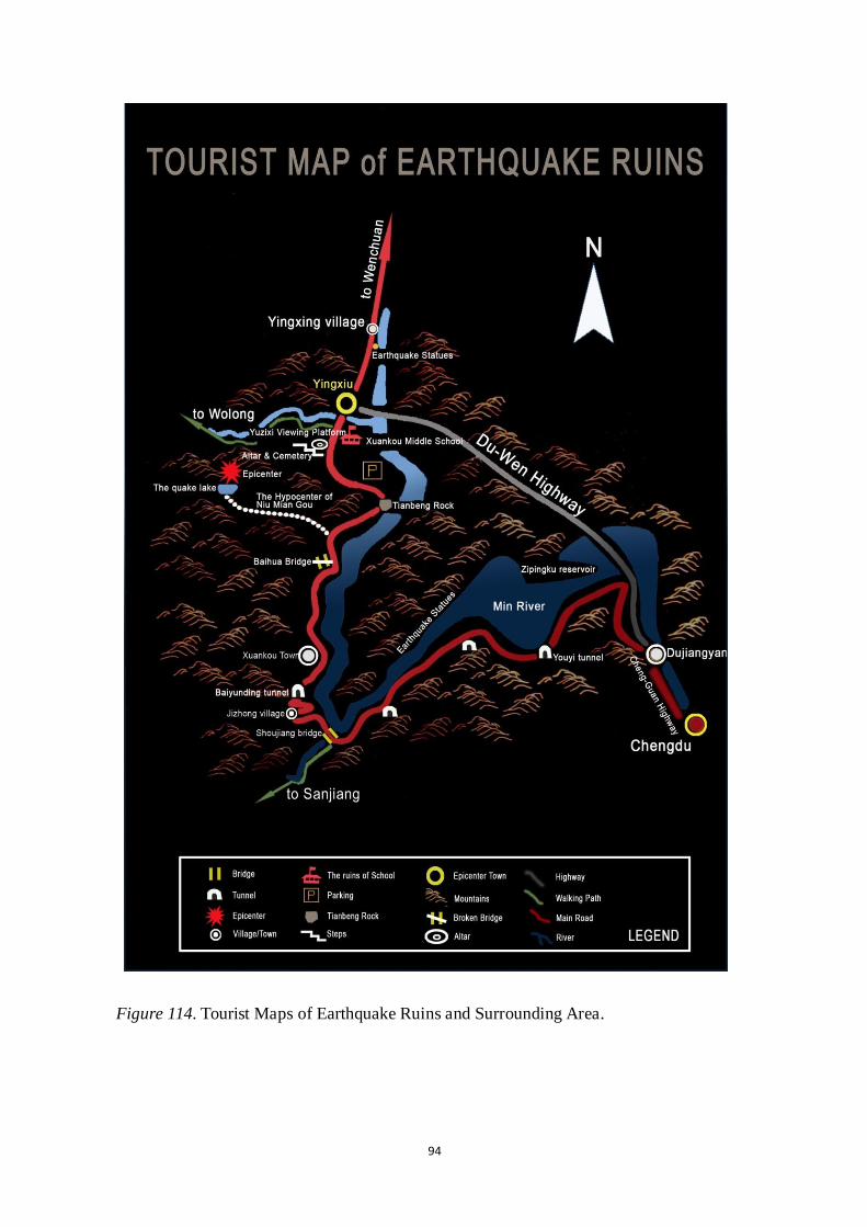
94
Figure 114. Tourist Maps of Earthquake Ruins and Surrounding Area.

95
Size and Zoning:
The government-proposed design boundary. (See Figure 115 red line area)
The new proposed design will be based on the government-proposed design and will focus
on the central area. (See Figures 116, 117)
My design is different from the government-proposed design in five aspects:
1. Preserve the ruins
In the government-proposed design, many important ruins were removed and
replaced by new constructions. For example, the Yingxiu Middle School was removed and
replaced by the new earthquake education center, which is not good for memorializing the
tragedy and victims with a living memorial.
In my design, I choose to preserve the ruins of Yingxiu Middle School as an
important symbol of the quake, in order to take good care of the natural and cultural
heritage and create a new and unique local landscape. Also, my design will preserve
natural and geological relics in the earthquake site, including an epicenter sign, fault
depression, landslide, debris flows, soil liquefaction, quake lake, and so on.
2. Preserve unique Aba Tibetan and Qiang culture heritage
In the government-proposed design, most of the new buildings and houses adopted
modern materials and styles, such as the museum and the earthquake education center,
which lost the unique local features of Aba Tibetan and Qiang culture heritage.
According to the survey, most people think that cultural elements should occupy
30%-50% of the total design. Therefore, I will preserve and use local materials and
features in my design.
3. Integrated Design
The natural disaster memorial park is not only a park, but should also be a piece of
green area with the function of providing refuge and shelter during disasters and for the

96
purpose of evacuation.
In the government-proposed design, they planned to build an evacuation radius of <
200 yards and cover the entire town, which is a good start, but also too general. More
specific disaster preparedness and prevention elements should be considered, such as
emergency signs, water supplies, and refuges and shelters.
However, my design integrates the disaster prevention function with usual park
functions, and provides different functional plans for both ordinary times and times of
disaster. An earthquake science and technology education center and public museum will
be built for the purpose of spreading knowledge about earthquakes and disaster
preparation.
4. Plants Selection
In the government-proposed design, I cannot find any reasonable planting plan to
explain which kind of plants should be planted and which should not.
However, in my design, I choose not only local plants, but also the plants that can
provide protection from wind and fire. I organized and listed the plants I would like to use;
additionally, some plants that catch on fire easily should be carefully placed, providing a
important reference for the designer in the future.
5. Creating the Multisensory Experience
In the government-proposed design, there is no detailed design about creating
multisensory experience.
In my design, I created multisensory experience using different elements and multiple
landscape layers, including public monuments, green grass, stone, lights and water, an
underground path, and artworks, all of which contributed to individuals‘ having a
memorable experience at the natural disaster memorial park.

97
Figure 115. Government-proposed design boundary.

98
Figure 116. Central area (base map: the government- proposed design).
Figure 117. Central area (base map: the original site after quake).

99
Natural physical features:
1. Landforms
Reasonable slope and landforms should be used to solve the drainage problem. The
refuge area should adopt flat terrain as the main landform and the gradient of slope should
be controlled within 1%-8% for quicker drainage.
From south to north, the topography is very diverse. The topography of the southeast
is relatively flat and natural, and the topography of the northwest is very hilly. Small hills
and slopes are added in the southern part to provide a different spatial experience, and the
west viewpoint hill provides an overview of the entire park. The trees and shrubs grow
denser along the borders of the park, forming a relatively enclosed interior space. Plants
are strictly organized around the entrance area, and others are planted naturally throughout
the park, including all kinds of grass, reeds, bamboo, and trees.
2. Water: Water will be used throughout the park in ponds and streams. The ruined
river—Min River—is the center of the water system, and from here it stretches throughout
the park.
Using reflection water creates a peaceful and healing atmosphere.
Running water combined with sculptures or display walls can provide an active space
that can attract more public participation and also can help visitors find release from their
sorrow.
3. Plants
Problems:
On the hills surrounding the site, there are only occasional clumps of shrub, offering
visual relief from its drab slopes
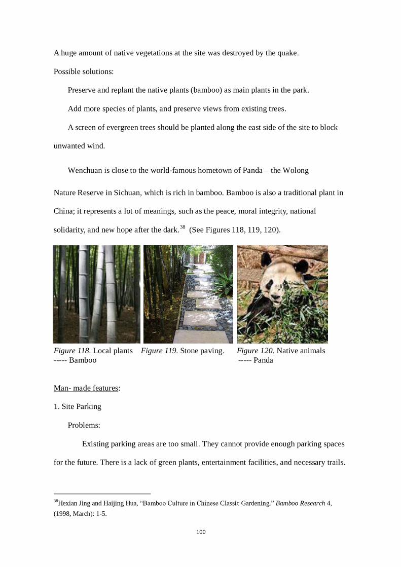
100
A huge amount of native vegetations at the site was destroyed by the quake.
Possible solutions:
Preserve and replant the native plants (bamboo) as main plants in the park.
Add more species of plants, and preserve views from existing trees.
A screen of evergreen trees should be planted along the east side of the site to block
unwanted wind.
Wenchuan is close to the world-famous hometown of Panda—the Wolong
Nature Reserve in Sichuan, which is rich in bamboo. Bamboo is also a traditional plant in
China; it represents a lot of meanings, such as the peace, moral integrity, national
solidarity, and new hope after the dark.38
(See Figures 118, 119, 120).
Figure 118. Local plants Figure 119. Stone paving. Figure 120. Native animals
----- Bamboo ----- Panda
Man- made features:
1. Site Parking
Problems:
Existing parking areas are too small. They cannot provide enough parking spaces
for the future. There is a lack of green plants, entertainment facilities, and necessary trails.
38
Hexian Jing and Haijing Hua, ―Bamboo Culture in Chinese Classic Gardening.‖ Bamboo Research 4,
(1998, March): 1-5.

101
Possible solutions:
Reorganize and add some parking and resting spaces.
Add proper plants and benches to create a comfortable public space.
Combine the parking area and sidewalk design.
2. Design of architecture
The entire town was demolished by the earthquake; most of the buildings and
constructions were completely destroyed, meaning there are not enough living places,
either for visitors or for local users. The quality of most constructions is very poor,
meaning they could not survive another quake in the future. Most rebuilt constructions and
buildings lost their local features, which were simple copies of buildings in other places.
The whole town should be rebuilt as the earthquake memorial site, and earthquake
prevention buildings will be designed for the local people and visitors.
New constructions should use local materials, use local style and features, and fulfill
the basic requirements of modern life.
Based on the research, buildings in the N.D.M.P should have anti-quake architectural
and fireproof structures, and they usually should be no more than 1-2 floors; the basement
can be used as temporary shelter from earthquakes. Leaving enough space between
buildings is good for fire prevention. Public buildings, such as an emergency command
center, a museum, and an emergency materials warehouse, should meet the higher design
standards of anti-seismic buildings.
Circulation (Path and Pavement Design)
Organize a memorial transportation system:
1. Memorial Path/Bridge connects important earthquake relics. Set some view points in
order to provide the best places for overlooking the entire earthquake site.

102
2. Create a strong feeling along the memorial path.
Underground Path: This path connects the ruins and the museum, representing the
connection between the past and the future. By intentionally making the entry path
circuitous, a sense of ritual and purification results, similar to the feelings that arise from
the sufferings that define the tragic experience.
The memorial paths are made out of white gravel and connect the various parts of the
park. Occasionally they widen to form fields, and sometimes they turn into bridges made
out of white painted wood spanning water or reeds. When black message stones are placed
on the paths, they stand out against the white background.
Paths: Straight memorial paths shorten the distance between the functional
areas, and the zigzag shape, which represent splits, will also evoke visitors‘ strong sense of
an earthquake.
Point Generated Circulation: Healing paths connect all the monuments and historic
points.
3. Disaster Prevention & Emergency Evacuation
Construct a public green belt while establishing emergency shelters and paths.
In order to ensure the normal flow of rescue vehicles, the main road and highway 213
need to be widened. The main road should be no less than 5 meters, with 1-meter grass
verge paving on both sides, so it can be used as a 7-meter-wide rescue path, and the whole
site should adopt a barrier-free design.
The surface of the pavement should consist of soft and anti-seismic materials, and the
roadbed should consist of hard material, in order to reduce the possibility of cracks or
subsidence after a quake.

103
Utilities:
1. Disaster Prevention
Problem: Limited disaster prevention design was used for the current site.
Possible solutions: Provide:
More public open space
Refuges/ Protected areas
Signage: Educational signs & training
Disaster Prevention Areas:
Evacuation radius < 200 yards; cover the entire town
Figure 121. Emergency sign. Figure 122. Evacuation radius.
Sensory:
1. Views
It is important to maintain existing views looking toward remaining buildings, such as
the concrete wall and broken window, which is strong and attractive.
2. Sounds
Heavy trucks, cars and nearby businesses can create a cacophony of intrusive noise. It

104
is important to reduce the traffic noise through effective landscaping.
Human and Culture: History and culture continuity
1. Preserve the ruins
As a national-level cultural relic, the earthquake ruin area is the natural and cultural
remnant that has many values, for example for scientific research, spirituality, education,
and culture. The design principle is to maintain the original status of the ruin and explore
necessary design ideas regarding its surrounding environments, in order to provide a richer
and safer tour.
The ruin is treated in two ways. The bulk of it is left exposed to the elements. On the
ground, the bushes are replaced with a water surface mirroring the ruin and emphasizing
the beauty of its decay as time goes by. This part of the ruin is to be seen from the outside
as a monument. The other part is incorporated into the museum; it is to be restored so that
visitors can walk safely through it. Shielded from the elements, it will be preserved in its
present state for future generations.
In this design, the most important ruin is Yingxiu Middle School. A glass cube will be
built that directs the view upwards and provides a place from which to see the inside of the
ruins. Visitors can go through the underground path and reach the glass house to see the
ruins inside. These are the main ruins:

105
The Ruins of Yingxiu Middle School:
The collapsed Middle School in Yingxiu, the
township at the epicenter of the quake, has been turned
into a 5/ 12 memorial. Forty-three students and eight
teachers were buried there.
Figure 123. The Ruins of
Yingxiu Middle School.
Tianbeng Rock:
At the moment of the 5/12 earthquake,
many rocks tumbled down. Some of them
slipped down to the bottom of the mountain,
while others crossed over the road and rolled
into the Minjiang River. Figure 124. Tianbeng Rock.
However, a high center of gravity rock that was 33‘ long, 27‘ high, and about 10‘ wide
rolled past the highway and landed at the riverside. This rock became one of the symbols
of the earthquake on the roadside of Duwen highway.
The Hypocenter of Niu Mian Gou:
The macro-epicenter was located at Niumian beginning
in the valley of Lianbua Xin and stretching to Caijia Gang
Village of Xuankou town, an area of about 982.8 acres (4
square kms). When the earthquake occurred, the power was
equal to that of 255 atomic bombs exploding
simultaneously.39
Figure 125. Bird‘s Eye View.
39白勇和樊力, “灵魂之震——汶川地震 120 小时.”商界 6,(2008): 1-16.

106
Figure 126. Niumian Gou Figure 127. The quake lake
Entrance Rock. -- Landslide dam.
Figure 128. Houses collapsed. Figure 129. Lianhua Xin Waterfall.
Broken Bridge:
Baihua Bridge, which was built in 2004, connected the towns of Xuankou and
Yingxiu. It swayed acutely during the earthquake. Nowadays, the ruins of bridge surfaces
and piers become important earthquake remains.
Figures 130. Broken bridge. Figures 131. Broken bridge. Figures 132. Broken bridge.
Yuzixi Viewing Platform:
Prefabricated housing was built for Yizixi villagers. Looking over from the viewing

107
platform, you can see all the ruins of Yingxiu town.
Figure 133. Looking over from Figure 134. Temporary refuges
Yuzixi Viewing Platform. -- prefabricated housing.
Earthquake Statues:
In the course of my survey, I found that the most vivid impression in the interviewees‘
minds were made by the altar and the earthquake statue, which are the unique geological
landforms caused by the earthquake.
Figure 135. Earthquake Statues Figure 136. Earthquake
-- Bulrush. Statues -- Chicken.
Altar and Cemetery:
Figures 137. Altar and Cemetery. Figures 138. Altar and Cemetery.

108
2. Preserve unique Aba Tibetan and Qiang culture heritage
Problems:
Culture is a big issue in design; especially in this case, much cultural heritage was
destroyed by the Wenchuan earthquake, including the Aba Tibetan and the Qiang
Autonomous Prefecture heritage. E.g.: The Qiang ―Diaolou‖ (Watch Tower) and Stone
houses. (See Figure 139)
Possible Solutions: According to the survey,
most people think that cultural elements should
occupy 30%-50% of the total design. Therefore, I
will preserve and use local materials and features
in my design.
Figure 139. Stone houses submerged
in flood.
Figures 139 retrieved September 5, 2009, from
http://ab.newssc.org/system/20100816/000989735.htm`
3. Education
Problems:
There were limited educational opportunities and medias for the local people to
get to know about the earthquake and how to escape from it, which caused a great loss
when the disaster happened; so earthquake knowledge popularization is a crucial issue.
Possible solutions:
Earthquake rescue and escape training center: A series of facilities for experiencing

109
the strong quake will be constructed. Many people can participate in disaster prevention
drills. Relevant organizations will issue information to the public about disaster prevention
and ways to cope with sudden disasters.
Public museum: Create a complete record of the ―5/12‖ Wenchuan earthquake using a
panorama, cultural relics, architectural sculptures, video media, and so on.
4. Memorials
The memorial elements will include: a memorial hall, memorial buildings, a museum,
ruins, a memorial greenbelt, a memorial plaza, a memorial wall, memorial paths, a
memorial landscape, educational buildings, an earthquake training and rescue center, and
so on.
Ceremony: Ceremony also can be a special form of memorial. We can see from the
chart that a national ceremony should be held in the memorial park. (The Chinese
government has set up ―5/12‖as the anniversary of the earthquake disaster to memorialize
the victims of the Wenchuan earthquake.) During the ceremony, participants can light
candles, or release or float lanterns, to remember and pray for the victims and survivors.
Figure 140. Floating Lanterns Figure 141. Releasing Lanterns
Figures 140-141 retrieved September 5, 2009, from
http://www. alighting.cn

110
Climate:
Problem: Windy weather:
Although Wenchuan is located in a river valley, its climate is nevertheless hot and
arid. Its average annual precipitation is less than 500 mm, even lower than Beijing‘s 585
mm. This makes it hard for trees and grass to grow on the mountain slopes. Most of its
precipitation also falls between June and August, with rainstorms giving rise to mudslides
that are fatal to the area‘s sparse vegetation.
Strong wind in the valley blows up the sand and dust, forming a huge yellow expanse
that blankets the whole county. The earthquake, which added more than 300 hazardous
spots such as landslides around the county seat, made the environmental situation worse.
Local residents say they have suffered from daylong sandstorms for half a month
following the quake.
Possible solutions:
Windbreaks are created by planting sufficiently dense rows or stands of trees at the
windward exposure of an open field subject to wind erosion (Mingyuan Du, 1998).
Evergreen species are preferred to achieve year-round protection.
Things as such as silt fences, fiber/mulch blankets, wattles, sediment traps, inlet
protection, and temporary seeding can be used to stop or contain the flow of silt and
sediment that may enter the watershed.

111
4.4.2 Conceptual Plan
4.4.2.1 Design Concept
1. Determine the theme:
Based on the on-site investigation, questionnaire forms, and interviews, first-hand site
information can be collected, which includes: special geological, landform changes and
various individuals, events, and objects that are worthy of being remembered as they
existed during the period of earthquake, disaster relief, and reconstruction. After scientific
analysis and evaluation, basic components of the memorial park system were summarized
and the purpose of the design was decided upon: to embody respect for nature, love of life,
and the history of the event, as well as to explore science and technology.
The overall theme for the project – ―a place of living memories‖— was inspired by
the traditional Chinese philosophy of the ―Tao,‖ which means ―path‖ or ―way.‖
A healing memorial path that is omnipresent throughout the park, constituting one of
its many layers and connecting different functional areas, was proposed for the memorial
park. Juxtaposed with greenery, monuments, and daily life, remembrance becomes a
natural part of the park.
The Zigzag Memorial Path: The path is a living memorial leading the way to the
bright future. It means that future generations should remember this great tragedy in order
to pursue a better life in the future. A series of zigzag paths stretches throughout the park,
luring the visitor forward. As a contemporary interpretation of the traditional Chinese
philosophy ―Tao,‖ the path becomes a symbol of remembrance and hope.
The relationship among grief-meditation-hope, black-gray-white, and
past-present-future recurs throughout the project, materialized in the relationships among
the paths, the water, the plants, the paper lanterns, and the ruins. (See Figure 142)

112
Figure 142. Conceptual Plan.
4.4.2.2 Functional Grouping and Zoning Maps in ordinary and disaster times
Create clear and well-connected multifunctional areas.
Function conversion—The natural disaster memorial park is a park, or a piece of
green area, with the function of providing refuge and shelter during disasters and for
purpose of evacuation. It is constructed with the intent of saving life and property, and to
enhance the functions of disaster prevention facilities, which makes the purpose of the
park difunctional. According to the design principles of N.D.M.P, an integrated design of
disaster prevention function and usual park functions is optimal, which means that
N.D.M.P functions as a memorial park during regular times and also plays a role in
disaster prevention and amelioration during times of crisis.
Functional zonings of N.D.M.P. in ordinary times (See Figure 143):
1. The Ruins Area - should be preserved.
2. Education Area - including the museum complex and the Earthquake Education

113
Center
3. Cemetery and Museum Area
4. Memorial Garden
Other functional areas are:
5. Public Transportation
6. Commercial Area
7. Public Square
8. Residential Area
Functional zonings of N.D.M.P. in disaster: Providing seismic shelters for evacuation
(See Figure 144)
1. Refuge Shelter
2. Emergency Command Center
3. Fireproofing Woodland Belt
4. Parking Area
5. Emergency Medical Care Area
6. Disaster Resistant Water Supply Area

114
Figure 143. The Functional Grouping and Zoning Map in Ordinary Times.

115
Figure 144. The Functional Grouping and Zoning Map During the Disaster.

116
4.4.3 Planting Plan
Multiple layers and different types of plants create a diversiform landscape. There are
different combinations that represent different themes, so they can evoke people‘s
different senses, as well as provide a natural healing place for people. The local plant
bamboo was used widely since it is not only an evergreen plant, which can benefit the
local environment, but also represents some spiritual ideas, such as solidarity and strength.
Thousands of bamboo trees were to be placed in the cemetery, each one representing one
victim who died in the earthquake.
In order to fulfill the requirements of disaster prevention, the plants should have three
basic features: 1.They should not catch on fire easily; 2. They should be hard, making
them less flammable; and 3. They should have thick leaves that contain a lot of water in
order to provide wind protection and shade, as well as to prevent the fire.
Evergreen trees with wide leaves will be the first choice.40
However, if only this kind
of tree is planted, the whole park will be very dark and not easy to escape from,41
besides
which the landscape will be simple and boring; therefore, it‘s better to combine evergreen
trees with some deciduous trees and flowers that can provide different landscapes in
different seasons.
The following information is the plant list for different areas.
(See Figures 145, 146)
1. 榉树 Zelkova serrata (Thunb.) Makino
2. 女贞 Ligustrum lucidum Ait.glossy privet
彩萼石楠 Calluna vulgaris / Heather,ling
榉树 Zelkova serrata (Thunb.) Makino
40
Jing-qi Li and Ji Xia, ―Study of Urban Disaster Prevention Park Planning.‖ Chinese Landscape
Architecture 7 (2007). 41 曹鹏程,“绿化带阻止火灾蔓延,小广场能降救援飞机.”环球时报 (2004).

117
枫香 Liquidambar formosana Hance
乌桕 Sapium sebiferum (Linn.) Roxb.
苦楝 Melia azedarace L.
无患子 Sapindus mukorossi Gaertn.
重阳木 Bischofia polycaroa (Levl.) Airy -Shaw
黄栌 Cotinus coggygria Scop.
3. Trees:
水杉 Metasequoia glyptostroboides
垂柳 Salix babylonica L.weeping willow
龙爪槐 Sophora japonica Linn. var. japonica f. pendula Hort.
枫杨 Pterocarya stenoptera C. DC.
乌桕 Sapium sebiferum (Linn.) Roxb.
香椿 Toona sinensis (A. Juss.) Roem.
Shrubs:
木芙蓉 Hibiscus mutabilis Linn.
栀子 ardenia jasminoides Ellis var. jasminoides
糯米条 Abelia chinensis R. Br.
枫香 Liquidambar formosana Hance
棣棠 Kerria japonica (Linn.) DC. f. japonica
Herbs:
山麦冬 Liriope spicata (Thunb.) Lour.
石蒜 Lycoris rosea Traub et Moldenke
鸢尾 Iris tectorum Maxim.

118
4. Trees:
槲栎 Quercus aliena Blume var. aliena
马尾松 Pinus massoniana Lamb. var. massoniana
苦槠 Castanopsis sclerophylla (Lindl. et Paxton) Schottky
南酸枣 Choerospondias axillaria (Roxb.) Burtt et Hill
麻栎 Quercus acutissima Carr. var. acutissima
小叶栎 Quercus chenii Nakai
Shrubs:
木芙蓉 Hibiscus mutabilis Linn.
栀子 ardenia jasminoides Ellis var. jasminoides
冬青 Ilex guangnanensis C. J. Tseng ex Y. R. Li
忍冬 Lonicera japonica Thunb.
Herbs:
山麦冬 Liriope spicata (Thunb.) Lour.
石蒜 Lycoris rosea Traub et Moldenke
络石 Trachelospermum jasminoides (Lindl.) Lem. var. jasminoides
5. 白玉兰 Magnolia heptapeta (Buchoz) Dandy
茶花 Rhododendron camelliiflorum Hook. f.
金丝桃 Hypericum bellum Li
6. Trees:
女贞 Ligustrum lucidum Ait.glossy privet
榉树 Zelkova serrata (Thunb.) Makino
栾树 Koelreuteria paniculata Laxm.

119
鹅掌楸 Liriodendron chinense (Hemsl.) Sarg.
香椿 Toona sinensis (A. Juss.) Roem.
臭椿 Ailanthus altissima (Mill.) Swingle
重阳木 Bischofia polycaroa (Levl.) Airy -Shaw
Shrubs:
粉团蔷薇 Rosa multiflora Thunb. var. cathayensis Rehd.et Wils.
冬青 Ilex guangnanensis C. J. Tseng ex Y. R. Li
紫荆 Cercis chinensis Bunge
胡颓子 Elaeagnuds davidii Franch.
映山红 Rhododendron simsii Planch.
Herbs:
鸢尾 Iris tectorum Maxim.
白三叶 Trrifolium repens L.
红花酢浆草 Oxalis corymbosa DC.
7. 紫竹园 Bamboo Garden:Phyllostachys munroblackjoint bamboo
8. 箭竹 Pseudosasa japonica Maki
9. Trees:
含笑 Michelia skinneriana Dunn
杜英 Elaeocarpus prunifolioides Hu var. prunifolioides
刺槐 Robinia pseudoacacia Linn.
泡桐 Paulowinia fortunei(seem.)Hemsl.
朴树 Celtis sinensis Pers.
Shrubs:

120
蚊母树 Distylium chinense (Fr.) Diels
夹竹桃 Nerium indicum Mill.
Herbs:
白三叶 Trrifolium repens L.
婆婆纳 Veronica henryi Yamazaki
紫花地丁 Viola philippica Cav.
10. 白杨 Populus lasiocarpaplplar
11. 梧桐 Firmiana simplex (L.) Wightphoenix-tree
12. 黄栌 Cotinus coggygria Scop.smoke-tree
女贞 Ligustrum lucidum Ait.glossy privet
13. 枫香 Liquidambar formosana Hance
15. 杜英 Elaeocarpus chinensis (Gardn. et Champ.Hk. f.ex Benth.
16. 无患子 Sapindus mukorossi Gaertn.
香椿 Toona sinensis (A. Juss.) Roem.
乌桕 Sapium sebiferum (Linn.) Roxb.
17. 白玉兰 Magnolia heptapeta (Buchoz) Dandy
银杏 Ginkgo biloba L.maiden-hair tree
结香 Edgeworthia chrysantha Lindl.
栀子 Gardenia jasminoides Ellis
红花酢浆草 Oxalis corymbosa DC.
18. 白玉兰 Magnolia heptapeta (Buchoz) Dandy
19. 含笑 Michelia szechuanica Dandy
鹅掌楸 Liriodendron chinense (Hemsl.) Sarg.

121
山茶 Camellia japonica L.
南天竹 Nandina domestica Thunb.
石蒜 Lycoris rosea Traub et Moldenke
麦冬 Ophiopogon japonicus (Linn. f.) Ker-Gawl.
Figure 145. Planting Plan.

122
Figure 146. Planting Plan.

123
4.4.4 Master Plan
1. Memorial Square (Main Entrance): A memorial and ceremonial place where we
pray for the people who are suffering from the disaster.
2. Bus station
3. Museum: Respecting the original site condition (low impact design. There are
several steps to develop it. (See Figure 147)
The museum will be positioned strategically in connection to the entrance and the
ruin.
Part of the ruin will be incorporated into the museum.
An underground path connects the ruins and museum, representing the connection
between the past and the future.
After passing an introductory exhibit, visitors can walk safely through the ruins.
The various second-floor exhibition halls can be unified through the core cross porch;
rooms on the first floor can be used for commercial purposes.
Figure 147. The design process of Museum.
4. Earthquake Science and Technology Education Center: The earthquake science
and technology education center is 1-2 floors higher than the other museum buildings, and
it serves as the focal point of the museum complex.
The earthquake science and technology education center will be 4-5 floors and will
be organized in the purple frame. The second and third floors will be the museum.
5. Underground Path: connects the Ruins and the Museum, representing the
connection between the past and the future. By intentionally making the entry path

124
circuitous, a sense of ritual and purification results, similar to the one that comes from the
sufferings that define the tragic experience.
6. Message Stone: Upon entering the park, the visitor passes a carved-out block made
up of 60,000 white cobblestones placed in bamboo meshes. Visitors can write a message
with white chalk on the stone and place it back in the mesh box. It provides a good way to
communicate with dead people by creating individual activities of remembrance. Bamboo
boxes become containers of memories and wishes for thousands of visitors.
7. Parking Lot
8. Reflecting Pools: Two reflecting pools in front of the ruins create sensory elements
that evoke emotion, and provide victims and their families with a place for contemplation,
healing, and rest.
9. Ruins: Yingxiu Middle School. Visitors can go through the underground path and
reach the glass house to see the ruins inside.
10. Glass Cube: Directs the view upwards and provides a place to see the inside of the
ruins.
11. Parking lots
12. Seat wall with Historic Timeline
13. Boardwalk
(See Figure 148)

125
Figure 148. Master Plan.

126
14. Visitor Center
15. West Entrance with Display Walls
16. Lawn Area over Graves: Each tree represents each victim, as well as regeneration
17. Memorial Hall: Primary area of focus, featuring memorial sculpture
18. Display of Artwork
19. Walls with Wenchuan Earthquake Artifacts and Stories
20. Memorial Path/Bridge & Milestone: to show all the important points/events
during the earthquake. (See Figure 149)
Figure 149. Memorial Path with Milestone.
21. Wooden Platform

127
22. Zigzag shaped Memorial Wall: Based on principle 5, people are a very important
memorial object, in order to pass on the legacy of disaster-stricken memory. A memorial
wall with victims‘ names can be built to honor and remember those people who lost their
lives during the disaster.
In my design, a grand monument is the black-granite, Zigzag-shaped Memorial Wall.
Inscribed on the wall are the names of 88,000
victims of the quake. (Names etched in granite send
a timeless message.) The zigzag shape also
represents seismic waves spreading and the
continuity of living memories. Figure 150. Memorial Wall.
Aspens were planted along the memorial walls; the wind blows across the trees,
creating a murmuring sound that emphasizes the sorrowful atmosphere.
23. Running Water with Color-Changing Lights: Provides illumination and sensory
experience for both day and night visitors. The sound of the waterfall will also block the
noise of outside traffic and help people to release their pressure and negative feelings.
24. Existing Building Foundation Featuring Displays of Artifacts & Artwork
25. Reflection Ponds with Debris and Bronze Statues: Combining reflection ponds,
which serve as a tribute to the spirits of the victims, with debris will create a sacred,
peaceful, and serene place for contemplation, healing, and remembrance.
26. Historic Path with Brick Pavers
27. Paths, Featuring Historic Information
28. Memorial Hills: Based on principle 5, Spirit is another important memorial
object, which includes the psychological or spiritual ideas. Abstract landscapes can be
used to represent or express different feelings and spirits, such as love, fear, courage, and
so on. In my design, there are three small hills standing above the ground to represent

128
Love, Faith, and Courage, which are also deeply rooted in everyone‘s heart. They are the
source of life as well as the spirit of the memorial.
29. Restroom
30. Benches below Tree Canopy
31. North Entrance with Display Walls: Based on principle 5, Process is also an
important memorial object; therefore, in my design, some display walls with information
tell the stories of the entire rescue process, including the selfless support from various
regions, the massive assistance from all walks of life, the cohesiveness of teamwork, the
refuge tents, and the process of restoration and reconstruction.
32. Memorial Sculpture
33. Paper Lanterns: A series of paper lanterns stretches throughout the park, luring
the visitor forward. ( * ) Lights as a living memorial represent a bright future. They
indicate that future generations should remember this great tragedy in order to pursue a
better life. As a contemporary interpretation of the traditional, a symbol of remembrance
and hope lies in the Chinese rice lamp. To reach visual and spatial variation, they differ in
scale and density, creating a
place of solitude and
remembrance. The lanterns
interact with their surroundings
in a number of ways. The
lanterns also double as sources of
illumination. (See Figure 151)
Figure 151. Paper Lanterns.

129
Figure 152. Master Plan.

130
4.4.5 Section Plan and Perspective:
Section Plan:
1. A—A‘ Section Plan: This portion of the plan shows the view of the walkway along
the riverside. (See Figure 153)
2. B—B‘ Section Plan: This portion of the plan shows the wooden platform and the
surrounding landscape. (See Figure 154)
3. C—C‘ Section Plan: This portion of the plan shows the memorial hills and the
surrounding environment. (See Figure 155)
Figure 153. A—A‘ Section Plan.

131
Figures 154. B—B‘ Section Plan.
Figures 155. C—C‘ Section Plan.
Perspectives:
A. Memorial Walls: Shows the view looking toward the memorial walls. (See Figure
156)
B. Memorial Bridge: Shows the view looking toward Memorial Bridge. (See Figure
157)
C. Lights and Running Water: Shows the view looking at lights and running water in
front of memorial walls. (See Figure 158)
D. Memorial Museum and Ruins: Shows the view looking toward the memorial
museum and earthquake training center and its connection with the ruins. (See Figure 159)

132
E. Visitor Center: Shows the view looking toward the visitor center with bamboo
planted around. (See Figure 160)
F. North Entrance: Shows the view looking from the north entrance toward the
memorial garden. (See Figure 161)
Figure 156. Memorial Bridge. Figure 157. Memorial Walls.
Figure 158. Lights and Running Water.

133
Figure 159. Memorial Museum and Ruins.
Figure 160. Visitor Center.

134
Figure 161. North Entrance.
4.5 Summary of the 5/12 Wenchuan Memorial Park Design
The design kept government-proposed business areas and residential areas. Several
green belts connected the memorial park and commercial areas, as well as residential areas;
meanwhile, similar local elements and characters were widely used in the park and
housing design, in order to enhance the connection between them, which made the whole
town a unified living memorial.
Wenchuan Earthquake Memorial Park is meant to encourage the ―people, process,
spirit‖ of the town and region; therefore, my proposed design of the memorial park can
achieve a sense of the continuity of past, present, and future for the people of the town in
three ways:
Through preservation of the Wenchuan earthquake ruins and resources, people
remember the past—the most tragic page in human history.
Through memorializing the earthquake spirit and the entire rescue process, including

135
the selfless support from various regions, the cohesiveness of teamwork, the refuges, and
the process of restoration and reconstruction, people create the present—the rebirth of the
quake-hit town.
By building the Wenchuan Earthquake Memorial Park and enhancing the scientific
development capacity of natural disaster preparedness and prevention through people
looking into the future, the Wenchuan earthquake ruins and memorial park will be
established as components of precious natural, cultural, and scientific heritage, and the
most unique tourism resource of Wenchuan.

136
4.6 Summary of the Design Project
The design project focused on the effects of memorial design elements (cultural
elements, physical elements, sensory elements and psychological elements) on a natural
disaster memorial park—the 5/12 Earthquake Memorial Park design.
4.7 Analysis of Project
The goal of this design project was to explore an ideal template program that was
summarized before and proved by the real case. It may provide a useful reference for
future designs.
4.8 Limitations and Further Applications
Several factors limited the design project. The first was the challenge of defining a
new design field: one for Natural Disaster Memorial Parks. Although there are many
memorials that were built to memorialize natural disasters, little literature exists that can
provide a clear and exact definition of the term. The second limitation was that the
comparison between W.M.P. and N.D.M.P. was not completed, and it still needs to be
improved. The third limitation was the broad nature of the survey, which covered too
many general topics and didn‘t get specific enough to delve deeply into each element. The
fourth limitation was a shortage of important resources. There was no clear site map and
other information; the design was based on the government-proposed design and some
unclear photos, so the design was influenced by the reality encountered. The fifth
limitation of this project was time: Specifically, this study did not delve into the length of
time that is required to establish a deep connection with space and people. There was not
much time to get enough information from the local people. The sixth limitation was that
most of the local people were not well-educated, and many of them didn't understand the
137
questions very clearly or were unable to give professional answers, so the survey itself
cannot provide enough useful information related to design. Lastly, the design project was
limited because it was not built; therefore, it is not possible to thoroughly evaluate whether
the memorial park proposal is applicable.
There are several directions for the further application of this literature within the
Natural Disaster Memorial Park design context. First, cultural issues and a definition of
sense of place can be applied to understanding and enriching the memorial experience for
different users. Second, the framework could be explored individually to express a place
for or kind of approach to the design of a memorial park. A third study would be similar to
this one, as it would use the framework in combination with various kinds of natural
disasters (such as hurricanes, fire, floods, etc.) to explore how each kind of natural disaster
would affect the outcome of the design project.
4.9 Strengths and Weaknesses
The overall goal of this project was to provide a framework that can be applied to
Natural Disaster Memorial Parks (N.D.M.P.). This study can be broken into three
segments or milestones that contributed to this goal. The first segment explored and
analyzed the literature and cases surrounding the topic of all kinds of memorial parks and
their basic features and differences. The study achieved this milestone with the definition
of N.D.M.P. and their basic functional areas. The second portion compared War
Memorials and Natural Disaster Memorials using different design categories. The last
segment used the knowledge gained from the case study and the survey to guide the
design framework of N.D.M.P. and used a real case—the 5/12 Wenchuan Earthquake Park
Design—to explain it. Although the ultimate measure of feasibility for the framework and
success for this design would take place through post-occupancy evaluation, I have

138
resolutely worked through reflection and critique to allow the case study and survey to
direct the design of the project.
In conclusion, the success of this study stems from the comparison between War
Memorials and Natural Disaster Memorials, as well as from some discussion about
disaster prevention parks. The idea of the preparedness and education element in my new
definition of Natural Disaster Memorial Parks, which Taylor didn‘t mentioned in his
definition, is also one of the contributions of my thesis. Did the study answer the research
question: What are the differences between War Memorials and Natural Disaster
Memorials? What kind of design elements and design principles should be applied to
N.D.M.P.? As the project remains conceptual, it is impossible to fully evaluate the
approach suggested in this project. However, this study revealed that some common
features can be found and used in future designs, based on numerous case studies and
surveys. This study provides a framework that can be applied to Natural Disaster
Memorial Parks. Through the design project, this study investigated how to enhance the
multisensory experience and memories of visitors through the different design elements of
the Natural Disaster Memorial Park to meet the needs of the creative visitors for a sense of
a living memorial. Thanks to the establishment of such parks, people and events will be
remembered forever.

139
Bibliography

140
B. Brian Taylor. Water‘s healing power. Architectural Digest 63, no.10 (2006, October):1-3.
Bin, Zhao, and Taucer Fabio. Field investigation on the performance of building structures
during the 12 May 2008 Wenchuan earthquake in China. Engineering Structures 31,
no. 8 (August, 2009): 1707-1723.
Carola, Hein. Shaping Tokyo: Land development and planning practice in the early modern
Japanese metropolis. Journal of Urban History 36, no. 4 (July, 2010): 447- 484.
Charles, J. Schencking. 1923 Tokyo as a devastated war and occupation zone: The
catastrophe one confronted in post earthquake Japan. Japanese Studies 29, no. 1
(May, 2009): 111-129.
F. Richard, Bales. Did the cow do it? A new look at the cause of the great Chicago fire.
(2004), http://www.thechicagofire.com (accessed January 14, 2010).
Ji, Xia. In the research on the planning and design of urban prevention park. Chinese
Landscape Architecture, (2006): 77-90.
Jing, Hexian, and Haijing Hua. Bamboo culture in Chinese classic gardening. Bamboo
Research 4 (1998, March): 1-5.
Jing-Qi, Li and Ji Xia. Study of urban disaster prevention park planning. Chinese Landscape
Architecture 7 (2007).
Joshua F.J. Inwood. Contested memory in the birthplace of a king: A case study of Auburn
Avenue and the Martin Luther King Jr. National Park. Cultural Geographies January
16 (2009): 87-109.
Katsutoshi, Suganuma. Recent trends in earthquake disaster management in Japan.
Quarterly Review 19 (2006): 91-95.
Kongjian, Yu. The culture that has been ignored, the beauty of weeds -- Qijiang park in
Zhongshan city. New Architecture May (2001).
Loures, L. and T. Panagopoulos. Sustainable reclamation of industrial areas in urban

141
landscapes. WIT Transactions on Ecology and the Environment 102 (2007): 1-4.
Maria, Dorsey. The effects of visiting the Vietnam Veterans‘ Memorial on adjustment to
bereavement. (August, 2006),
http://edt.missouri.edu/Summer2006/Thesis/DorseyM-072706-T5740/research.pdf
(accessed April 7, 2009).
M. La Fargue. The Tao of the Tao Te Ching: A translation and commentary (Albany: SUNY
Press, 1992).
Musgrove, Charles D. Monumentality in Nanjing‘s Sun Yat-sen Memorial Park. Southeast
Review of Asian Studies 29 (2007): 1-19.
P. Melby and T. Cathcart. Regenerative design techniques: Practical applications in
landscape design. (John Wiley & Sons Inc., May 2002).
Puying, Wu. Functions of urban green space and plant selection for reduction and prevention
of urban disaster. Zhongguo Yuanyi Wenzhai 25 no. 07 (2009).
Rebecca C., Retzlaff. The Illinois forest preserve district act of 1913 and the emergence of
metropolitan park system planning in the USA. Planning Perspectives 25, no. 4
(October, 2010): 433- 455.
Roy, Rosenzweig. The politics of park design: A history of urban parks in America. Journal
of Social History 18, no. 2: 289.
Sonja, Duempelmann. Creating order with nature: Transatlantic transfer of ideas in park
system planning in twentieth-century Washington D.C., Chicago, Berlin and Rome.
Planning Perspectives 24, no.2 (April, 2009): 143-173.
State Council Circular on Printing and Distributing the Overall Planning for Post-Wenchuan
Earthquake Restoration and Reconstruction. Documents of the State Council, no. 31
(2008): 31-67.
Tao Zhu, Suihong Kong and Bo Lan. Research on planning of urban seismic shelter in

142
Guangxi. Cities and Towns Construction in Guangxi, no. 06 (2009): 83-86.
Taylor, Brian B. Water‘s healing power. Architectural Digest 63, no. 10 (2006, October):
1-3.
Tsunami memorial winner: Mountains of remembrance. Tsunami Memorial Design
Competition, 2006,
http://inhabitat.com/2006/06/18/tsunami-memorial-winner-mountains-of-
rememberance (accessed June 11, 2010).
Xiumei, Lu. The plan research of disaster-proof parks. Journal of Hebei Institute of
Technology 28 no. 4 (2006).
Y. Li and Y. Yang. The Research on Functional Adaptation of Campus as a Shelter after
Earthquake. Urbanism and Architecture 3 (2009): 1-23.
Yue, S. and Y. Saito. Inspirations from the disaster prevention with public green space in
Japan. Chinese Landscape Architecture (2007): 6-10.
Yunzhu, He. Creation of the holy space — An analysis of Tadao Ando‘s ‗Church on the
Water.‘ Architecture & Culture 1 (2009): 5-20.
Zhongyu, Liu. The relationships between Confucianism, Buddhism, Taoism and folk custom.
Shijie Zongjiao (1996): 24-32. (Regarding ―baibai‖ as the term for the act of offering
incense as a form of worship.)
Zhong, Liu. Burning incense and worshiping spirits. Daoist Folk Customs. Daoist Culture
and Information Centre.
白勇和樊力, ―灵魂之震——汶川地震 120 小时.‖商界 6,(2008): 1-16.
曹鹏程, ―绿化带阻止火灾蔓延,小广场能降救援飞机.‖环球时报 (2004).
刘川和徐波等,―日本阪神、淡路大地震的启示.‖国外城市规划 4, (1996): 2-18.
马亚杰,苏幼坡,刘瑞兴,―城市防灾公园的安全评价.‖安全与环境工程 1 , (2005): 50-52.

143
Appendices

144
Appendix A:
Questionnaire and Results of the 5.12 Earthquake Site Survey

145
5.12 EARTHQUAKE SITE SURVEY
汶川地震遗址调查 Linjun Yang – Summer 2009 / 杨琳君 – 2009 年夏
Washington State University,U.S. / 华盛顿州立大学,美国
1. What’s your identity in Wenchuan? / 您在汶川的身份是?
□ Local person /当地居民 □ Local official 地方官员 □ Tourist 游客 □ Other/ 其它________
2. Why do you come here? /请问您来这儿的目的是?
□ Visiting /参观 □ Studying 学习 □ Memorizing 悼念 □ Other/ 其它_________
3. Have you participated in any earthquake prevention maneuvers or know some related
knowledge about earthquake prevention? 您参加过防灾演习或通过一些渠道了解过防灾
避难的相关知识吗?
□ Yes /有(where/which medium? 哪里/ 哪种媒介?)_________________
□ No/ 无
4. When the disaster happened, which place below you would consider as the best one to
go?/灾害发生时,您会优先选择以下的哪个地方避难?
□ Residential Park /居民区公园 □ Public park, plaza /大公园,广场 □ Earthquake prevention
building, basement/抗震建筑,地下室 □ Hospital/ 医院 □ Other/ 其它________
5. How important is a public park to you in serving as a memorial of this tragedy? / 您认
为建设灾害纪念公园的重要性有多少? (select between 1 to 5, with 1 being the least and 5
being the highest /从 1—5,依次代表从程度由低到高): 1,2,3,4,5
6. Which county do you think is the best site for building the 5/12 earthquake memorial
park? /如果要建 5.12 地震纪念性公园,您认为最佳的选址是:
□ Wenchuan/汶川 □ Yingxiu/映秀 □ Beichuan/北川 □ Beijing/北京 □ Other/其它____
Reason:/原因: __________________________________________________________________
7. 哪个地方对您的印象最深刻?/ Where is the most impressive place in your mind?
□ Earthquake statue/地震壁画 □ Niumian Channel/牛眠沟 □ Altar/祭坛 □ Other /其它______
Reason/原因: _________________________________________________________________

146
8. What aspects of the current memorial park do you think are deficient? /您认为现有的纪
念公园有哪些不足?(例如:避难标志是否明显,设施是否齐全,功能是否合理等等)
______________________________________________________________________________
9. What functions do you think the earthquake memorial park should have? / 您觉得地震
纪念公园应具有的功能有哪些?
□ Memorial/纪念 □ Ecological/生态 □ Disaster prevention/防灾 □ Education/教育
□ Tourism/旅游 □ Recreation/娱乐 □ Scientific research/科研 □ Other/其它_________
10. Please select the most important elements you would want to see in a memorial park: /
请您选择以下您最希望在纪念公园中看见的元素:
□ Green grass /绿草地 □ Water feature/ 水景(喷泉,水池等) □ Stone / 石
□ Artwork / 艺术品 □ Public monuments / 纪念碑 □ Other/ 其他 ____________
11. Many cultural heritages were destroyed by the Wenchuan earthquake, such as those of
Aba Tibetan and Qiang Autonomous Prefecture. What percentage of cultural elements do
you think should be included in the earthquake memorial park? / 汶川特大地震破坏,阿坝
藏族和羌族文化遗产受损极为严重。您认为在未来地震纪念公园设计中当地文化元素应占
的比例是?
□10%或以下 □10%—20% □20%—30% □30%—40% □40%—50% □50%以上
12. What’s your feeling about the earthquake? / 请您描述下对这次地震的感受:
___________________________________________________________________________________
___________________________________________________________________________________
___________________________________________________________________________________
NOTICE: The purpose of this survey is to collect comments on the Earthquake Memorial Park design. Your
personal information will be kept confidential and nothing about you personally will be identifiable. This
survey is for an academic design project only and it will not be published to the public. (注意:这项调查的
目的是为了搜集民众对建设 5.12 地震纪念公园的态度及看法。这项报告不涉及填写人的任何私人信息。
以上所有信息仅限用于学校设计项目的资料,而非对外发表。)
I understand all the information above. / 本人完全理解以上信息。
Signature / 签名: _____________________________________________________________________

147
5.12 EARTHQUAKE SITE SURVEY
Linjun Yang – Summer 2009
Washington State University,U.S.
I did a survey at the earthquake site—Wenchuan in China in the summer of 2009. In order to make this
survey more comprehensive and involve all kinds of people, I also did a survey in some other cities, such as
Wuhan, Beijing, and Chengdu. In this random sample, I find that more than half of the interviewees are
tourists (150 of the total); the local people and officials who are the direct victims played only a small part it in
the survey responses— nearly 10%. More than 30% of the interviewees are from other cities outside
Wenchuan. They as bystanders also shared their feelings about and understanding of the earthquake and gave
some thoughtful suggestions to the site design. Their main purpose to this site is visiting and memorializing.
Nearly 64% of the interviewees have participated in some earthquake prevention maneuvers held by
schools or government, or had gained some related knowledge about earthquake prevention through other
media, such as TV and the Internet. However, 37% of the interviewees have never received evacuation training
or information about earthquake prevention. That result shows that we should provide more earthquake
prevention design or notice in the future park design.
In order to better understand how well they know about earthquake prevention, I asked them where they
went immediately after the earthquake. The results are shown below:

148
Most people will choose an open park or a plaza as their first place to go; some people also will choose to
hide in the basement of earthquake prevention buildings. This data illustrates that a public park will provide a
shelter and take a significent role in disaster reduction.
Do local and nonlocal people find it necessary to build a public park to serve as a memorial of this tragedy?
In order to prove this, I let them select between 1 and 5, with 1 representing the least importance and 5
representing the most. The results show that most people think it is important to build a memorial park. I
interviewed 15 local people, and they told me that building a memorial park is very desirable for them because
it can attract more visitors and it may constitute their only money supply in the long run. For the visitors, they
want to memorialize those victims and know better about the disaster, so a natural disaster memorial park is
needed.
For the question: ―What place do you think is the best site for building the 5/12 earthquake memorial
park?‖ 60% of the people chose Wenchuan because it is where the earthquake happened, and 20% of the
people chose Beichuan, where many young students are buried. Also, 12% of the people chose Yingxiu
because it is the earthquake center which has the most serious damage, and nearly 6% of the people chose
Beijing because they think the capital has the most influence on the whole country, which can make us attach
importance to this big event.

149
It is significant to know what the most impressive place in visitors‘ minds is, in order to organize the site
for the future design. I found that the greatest impression was made in their minds by the altar and cemetery,
and earthquake landforms, which consist of unique geological landforms caused by the earthquake.
Through the research, I also found that the current memorial site is just the remains of the earthquake. It is
deficient in many aspects, such as having no obvious sign for an emergency exit and no disaster prevention
place, insufficient fireproofing facilities.
I asked what functions they thought the earthquake memorial park should have, and the results are below:
I asked them to select the most important elements they would want to see in a memorial park:
Culture is a big issue in design. This is especially true in this case, in which much cultural heritage was
destroyed by the Wenchuan earthquake, such as those of Aba Tibetan and Qiang Autonomous Prefecture. I
wanted to know what percentage of cultural elements they thought should be included in the earthquake
memorial park.

150
From the chart above, most of people think that cultural elements should occupy 30%-50% of the total
design.
At the end of my interview, I also asked about their feelings about the earthquake. I collected these
feelings in order to deeply understand people‘s mentality change and their attitudes toward this event. Based
on that information, I create different spaces depending on different senses.

151
Appendix B:
Presentation Posters

152

153

154

155

156

157
Appendix C:
Case Study Checklist

158
No. Case Page
1 Vietnam Veterans Memorial 15
2 Deportation Memorial (World War II) 17
3 3. 9/11 Memorial Park 20
4 4. USS Arizona Memorial (USAR) 22
5 Nanjing Massacre Memorial Hall (China) 24
6 Berlin Holocaust Memorial 26
7 Kobe Port Earthquake Memorial Park 29
8 Smriti Van Earthquake Memorial 33
9 Taiwan Chi-Chi Earthquake Memorial 34
10 Tangshan Earthquake Memorial Park 36
11 Tsunami Memorial in Khao Lak 41
12 St. Bernard Hurricane Memorial 43
13 The Florida Keys Memorial 45
14 Wuhan 1954 Flood Memorial 47
15 Chicago Fire Memorial 49
16 Osu Disaster Prevention Park 51
17 Wuhan Riverside Park & Flood bank 54
18 Martin Luther King Memorial Park 56
19 The Washington Monument 58
20 Church on the Water 59
21 Church of the Light 60
22 Qijiang Park in Zhongshan City 61
23 Nanjing Dr. Sun yat-sen's Mausoleum 64

159