a high-level overview of the consortium for advanced
TRANSCRIPT

A High-Level Overview ofThe Consortium for Advanced Research on Transport p
of Hydrocarbons in the Environment (CARTHE)
Brian K HausBrian K. HausTamay Özgökmen (PI), University of MiamiSOST workshop, October 2011, St. Petersburg

Processes Affecting Transport in Deep Water Oil Blow-Outs:

Our Main Goal:
To accurately predict the fate of hydrocarbons released into the environment, thereby guiding risk management and response efforts to minimize damage to human health, the economy and the environment.

This goal will be achieved through:This goal will be achieved through:
(A) Interconnection of a number of state-of-the-art ( )hydrodynamic models across a vast range of spatial and temporal scales of motions caused by different physical processes;
(B) A dedicated set of in-situ and laboratory experiments d i d f d l l ti d t i tidesigned for model evaluation and parameterization;
(C) Uncertainty analysis to asses model performance and(C) Uncertainty analysis to asses model performance and solution space.

Summary of CARTHE’s Innovative Aspects and Team Members:
• Buoyant plume modeling through Large Eddy Simulation (LES): Özgökmen, Poje (CUNY), also Fischer (ANL).
• Near-surface wind/wave driven Langmuir circulation modeling (Zha, UM) and a three-phase air-sea-oil model (Soloviev NSU)(Soloviev, NSU).
• Coupled ocean-wave-atmosphere modeling systems with extensive experience in tropical storms: Chen,with extensive experience in tropical storms: Chen, Donelan (UM), Jacobs (NRL prediction group)
• Atmospheric LES model for small-scale feedback to pocean models: Zhu, FIU
• Connectivity across shelf break to land fall using coastal (Dawson, UT Austin) and surf zone models (Reniers, UM; MacMahan, NPS)

• Expertise in 2D and 3D transport analysis using theory (Dewar, FSU) and Lagrangian Coherent Structures: Haza, Olascoaga, Griffa (UM), Kirwan, Lipphardt, Huntley (UD)
I it di i (UM PI ) f t b l• In-situ dispersion (UM PIs), near-surface turbulence (Bogucki, TAMU-CC) and bottom oil (Rosenheim, Tulane) observations
• Laboratory experiments of air-sea interaction at ASIST and SUSTAIN salt water wind-wave facilities (Haus, UM)
• Novel uncertainty quantification tools: Iskandarani, Srinivasan, Mariano (UM), Restrepo, Venkataramani (UA)

Buoyant Plume Model: (Özgökmen, Poje, Fischer)

LES of a plume interacting with mixed layer flows (Özgökmen, Fischer)

Multiphase Air-Sea Interface Model Including Hurricane Conditions (Soloviev, NOVA)
Wind stress 4 N m-2Wind stress 4 N m
• 1000-fold density difference between air and water is handled
Will b d d i l d hi d h l il• Will be extended to include a third phase, namely oil.

Ocean-Wave-Atmosphere Coupled Model: Forecast of Hurricane Katrina (Chen, Donelan, UM)
R iRain
SST and oceansurface currents

Data Assimilation and Operational Forecasting Expertise with Coupled Ocean-Wave-Atmospheric Models (Jacobs & prediction team, NRL)
Example of CARTHE work initiated
• 16 ensemble members have been
Ensemble average of concentration injected at DWH site:
16 ensemble members have been initiated starting at the DWH event time.
• A constant inflow of contaminant is i j t d i t h b binjected into each member by a simple 2D surface dispersion model.
• The results show the possibility of three main possible paths. NOAA analysis of observed oil positionp p
• Two paths (black arrow) follow the observed trajectory.
• One other paths(red arrow) shows
NOAA analysis of observed oil position
that forecasts errors could lead to incorrect application of resources if the error information is not accounted for.

High-Resolution Coastal Model: ADCIRC+SWAN (Dawson, UT-Austin)
- Evaluation against satellite-observed spill extents provided by NOAA NESDIS.g p p y- Overlap of 60% of observed spill, even a full week into the simulation.- Research thrust: improve circulation and transport in the nearshore including 3D and
biogeochemical effects.

Near-shore Model - Transport in the Surfzone Using Delft3D and Experiments: (Reniers, UM; MacMahan, NPS)
Inner shelf
W
Rip current
beach
Wave rays
Surf zone
Rip currents
Rip currentRip current
GPS drifters

A Transport Analysis Tool – Lagrangian Coherent Structures (UM and UD PIs): To Identify Transport Barriers in Time-Dependent Velocity Fields
2D LCS:
“Forbidden zones” in the GoM circulation area (left panel, Olascoaga);
Application of 2D LCS to understand areas of uncertainty caused by chaotic regions for the DWHApplication of 2D LCS to understand areas of uncertainty caused by chaotic regions for the DWH spill using the intersection of backward (red, stretching) and forward (blue, uncertainty) in time transport barriers (right panel, Huntley, Kirwan, Lipphardt).

3D LCS (Özgökmen and LLNL): computed from ~100 million particles releases
I t t t d t d h ti l ti i ddi d i fl t tImportant to understand how vertical motions in eddies and waves influence transport

Why Do We Need A Lagrangian Dispersion Experiment?
LCS from
1/12 degree OGCM1/12 degree OGCM
1/48 degree OGCM g
• Which turbulent features control the transport?
• Are the long-living, slow mesoscale features enough to compute transport?
• Or, rapidly-evolving, smaller submesoscale transport barriers are needed?
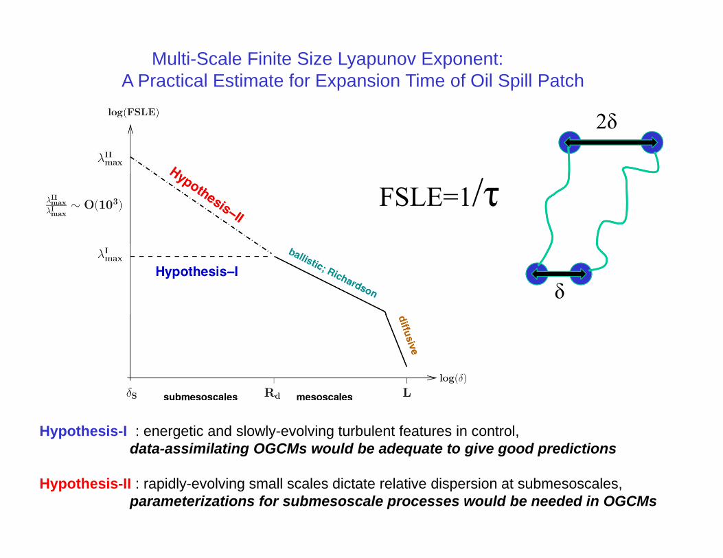
Multi-Scale Finite Size Lyapunov Exponent:A Practical Estimate for Expansion Time of Oil Spill Patch
2δ
FSLE=1/τ
δ
Hypothesis-I : energetic and slowly-evolving turbulent features in control,data-assimilating OGCMs would be adequate to give good predictionsg q g g p
Hypothesis-II : rapidly-evolving small scales dictate relative dispersion at submesoscales,parameterizations for submesoscale processes would be needed in OGCMs

Multi-Scale Drifter Deployment Module and A-Priori Error Analysis
~100-200 drifters will be deployed near the DWH site;never been done at this scale
positions and dispersion can be accurately measured toto quantify both model evaluation and parameterization

Project Timeline:
• Year 1:
Idealized studies of transport within individual components- Idealized studies of transport within individual components- Historical reconstruction of DWH event from OGCM hindcasts- Coupled modeling- Lagrangian dispersion experiment
• Year 2:
- Integration of modeling componentsIntegration of modeling components- Quantification of submesoscale transport- Model evaluation and submesoscale parameterization- Surfzone experiments and laboratory tank results
• Year 3:
- Effect of extreme events (hurricanes) on oil dispersionEffect of extreme events (hurricanes) on oil dispersion- Uncertainty quantification and hazard maps

Management Structure:
CARTHE Kick-off Meeting: 17-18 November, 2011, at UM

• THANKS VERY MUCH FOR THIS GREAT OPPORTUNITY!!!
• We are looking forward to establishing close tieswith other GRI consortia.

CARTHE Outreach (Mariano, Pitman):Our goals are to (i) bring exciting, multidisciplinary science to children, especially underrepresented students, (ii) present our research findings to the public, and(iii) exchange information with scientists and public officials.
• Publicly available presentations with lecture notes on the GoM Oil Spill• Series of high school level science lecture modules to teach important
multidisciplinary scientific topics, using the GoM oil spill as our prime example, will be developed with the Miami-Dade County School Systems and the Upward Bound Math and Science/IMPACT Program.and the Upward Bound Math and Science/IMPACT Program.
• Public seminars and outreach events at host institutions.• LAPCOD meetings will have dedicated sessions for GoM oil spill; special
sessions at AGU, EGU, and Ocean Science Meetings• The Ocean Current Web Site:
A web-based educational reference site for ocean/coastal currents and phenomena that will
t i ti l f ll th jcontains summary articles of all the major oceancurrents, schematic maps of ocean circulation, basic concepts and glossary of oceanographic terms, ocean data, summary figures, and external links to other educational and research sites.

Portable (off-line, any mesh), parallel tracer advection code (Poje):

Large Eddy Simulation of Langmuir Circulation (Zha, UM)
Background: LC creates organized oil spill pattern on ocean surfaceUnderstanding LC crucial for oil spill Mitigationg p gLC not currently incorporated in global circulation/climate models
S i tifi U kScientific Unknowns:Turbulence of LC, breaking waves effect,Instability growth of small structures, Interaction of large coherent vortices Langmuir CirculationInteraction of large coherent vortices with small cells
Strategies:Large Eddy Simulation of turbulenceHigh order WENO scheme withhigh resolution Riemann solver for air/water Interface discontinuitya /wate te ace d sco t u ty
Level set/volume of fluids for breaking waves Simulated Shock discontinuity interaction
with shear layer

Air-Sea Interface Laboratory Experiments(Haus, UM)
Air-Sea coupling in Extreme Winds (Chen)p g ( )
Langmuir Circulations, turbulence (Zha,Soloviev, Bogucki)
Surfactant effects (Soloviev) Surfactant effects (Soloviev)
Multi-phase model validation (Zha)Surfactant damping of surface waves in ASIST, U10 7 m/s (Soloviev et al., 2011)
Spray Ejection from breaking wave in RSMAS ASIST lab, U10 40 m/s
RMAS SUSTAIN- model validation strategy

N f t b l t (TAMU CC B ki)Near-surface turbulence measurements (TAMU-CC, Bogucki)
• We plan to carry out shallow water turbulence/particle dynamics measurements using our ROV equipped with the Optical Turbulence Sensor (OTS) and a traditional shear sensor (VMP200)(VMP200).
Particulate: OTS in theThe OTS and VMP 200 mounted on the ROV during tests in the swimming pool.
Turbulence: Comparison of temperature dissipation spectra: OTS, thermistor, PIV.
Particulate: OTS – in the shadowgraph mode, a single 500 m particle embedded in the turbulent flow.

Model Integration:

Fundamentals of 2D Dynamical System Theory:
Particles diverge when released along blue ridges; forward in time advection identifies blue ridgesforward in time advection identifies blue ridges
Particles converge when released along red ridges;Particles converge when released along red ridges; backward in time integration is needed to identify red ridges
Intersections of blue and red ridges are hyperbolic trajectories g yp jthat cause chaotic stirring in time-dependent flow fields.

17% recovered by surface vessels5% burned3% skimmed16% chemically dispersed16% chemically dispersed13% naturally dispersed24% evaporated22% unaccounted