a high-resolution stable isotopic record from the junggar
TRANSCRIPT

HAL Id: insu-00715969https://hal-insu.archives-ouvertes.fr/insu-00715969
Submitted on 10 Jul 2012
HAL is a multi-disciplinary open accessarchive for the deposit and dissemination of sci-entific research documents, whether they are pub-lished or not. The documents may come fromteaching and research institutions in France orabroad, or from public or private research centers.
L’archive ouverte pluridisciplinaire HAL, estdestinée au dépôt et à la diffusion de documentsscientifiques de niveau recherche, publiés ou non,émanant des établissements d’enseignement et derecherche français ou étrangers, des laboratoirespublics ou privés.
A high-resolution stable isotopic record from theJunggar Basin (NW China): Implications for the
paleotopographic evolution of the Tianshan MountainsJulien Charreau, Malinda Louise Kent-Corson, Laurie Barrrier, RomainAugier, Bradley D. Ritts, Yan Chen, Christian France-Lannord, Caroline
Guilmette
To cite this version:Julien Charreau, Malinda Louise Kent-Corson, Laurie Barrrier, Romain Augier, Bradley D. Ritts, etal.. A high-resolution stable isotopic record from the Junggar Basin (NW China): Implications forthe paleotopographic evolution of the Tianshan Mountains. Earth and Planetary Science Letters,Elsevier, 2012, 341-344, pp.158-169. �10.1016/j.epsl.2012.05.033�. �insu-00715969�

A high-resolution stable isotopic record from the Junggar Basin
(NW China): implications for the paleotopographic evolution of the
Tianshan Mountains
Julien Charreau
1, Malinda Louise Kent-Corson
2, Laurie Barrier
3, Romain Augier
4, Bradley D. Ritts
5, Yan Chen
4,
Christian France-Lannord1 and Caroline Guilmette
1,6
1. Université de Lorraine, Centre de Recherche Pétrographique et Géochimique, 15 rue Notre Dame des
Pauvres, 54501 Vandoeuvre lès Nancy, France, phone : (33)383594227 Fax: (33)383511798,
[email protected], [email protected], [email protected]
2. Nanyang Technological University; Division of Earth Sciences; 50 Nanyang Ave., Singapore 269269;
Phone : (65) 65927542 Fax: (65) 67901585; [email protected]
3. Institut de Physique du Globe de Paris, 4 place Jussieu, 75252 Paris Cedex 05 FRANCE; Phone: 33-
1.44.27.49.34, Fax: 33-1-44277463; [email protected]
4. Institut des Sciences de la Terre d’Orléans; 1A, rue de la Férollerie, 45071 Orléans Cedex 2, Orléans Cedex
2, France; [email protected], [email protected]
5. Chevron Asia Pacific Exploration and Production, 30 Raffles Place 08-00, Singapore 048622; Phone; (65)
63181917, [email protected]
6. Now at: Centre d'étude Nordique-Takuvik, University of Laval, 1045, Avenue de la Médecine Québec,
Canada, [email protected]
* Corresponding author: [email protected]
Abstract
This study presents high-resolution oxygen and carbon isotopic records of paleosol
carbonates from fluvial sediments and lacustrine carbonates, sampled from the Jingou He and
Kuitun He stratigraphic sections, located in the northern Tianshan piedmont. These sections
expose remarkable outcrops of Junggar foreland basin sediments that have been previously dated
by high-resolution magnetostratigraphy to between ~23.6 and ~1 Ma, and ~10.5 and ~3.1 Ma,
respectively. A total of 216 samples of fluvio-lacustrine sediments were collected from which
isotopic analyses yield 18
O (SMOW) values that range from 13.7 to 29.9‰ in the Jingou He
section, and 16.3 to 21.0‰ in the Kuitun He section. 13
C (PDB) values range from -12.9 to
3.0‰ in the Jingou He section and -7.8 to -4.0‰, in the Kuitun He section. 18
O values decrease
between 25 and 23 Ma, and then remain relatively steady, with the exception of one period that
contains samples with higher oxygen isotope values at 16 Ma. During the periods when there
are samples that overlap in time from the Kuitun He and Jingou He sections, we observe a
difference of ~1.7‰ between values from the two locales. The 13
C values also decrease

between 25 and 23 Ma, and then remain relatively steady until 10 Ma with, again, one short
period of higher values 16 Ma. Then, between 10 and 3.1 Ma, carbon isotope values
progressively increase. We interpret that 18
O and 13
C isotopic values during lacustrine periods
(25-23 Ma and 16 Ma) as largely controlled by evaporation and opening/closing of the lake to
external inputs. We interpret the 18
O values of paleosol carbonate in the Junggar Basin to be
influenced by the hypsometry of the high Tianshan range while the 13
C values may record the
uplift history of the depositional area in the foreland basin itself as well as the isotopic
composition of plants. Consequently, we conclude that the Jingou He and Kuitun He drainage
basins in the Central Tianshan have remained at relatively unchanged elevations for the past 20
Ma. We also suggest that the elevation of the southern part of the foreland basin increased
between 10 to 3.1 Ma, probably as a result of tectonic deformation in the piedmont and
sedimentary filling of the sedimentary basin. The carbon isotope record remains relatively stable
through time, and isotopic values suggest that there was little or no expansion of C4 plants in this
region in the late Miocene.
1. Introduction
Mountains are the complex expression of the interactions between tectonic deformation,
climate, and surface processes such as sedimentation and erosion (e.g Avouac and Burov, 1996;
Beaumont et al., 1988; Burbank, 1992; Cobbold et al., 1993; Koons, 1987; Molnar and England,
1990; Whipple and Meade, 2006), both of which drive mass transfer from the uplifting zone
toward the flanking basins (e.g. Charreau et al., 2009b; Métivier et al., 1999; Zhang et al., 2001).
To better decipher the relative impact of these processes, long term and quantitative estimates of
paleotopographic variations are needed. This is particularly true in Asia, where the India
collision that began ~55 Ma ago (Leech et al., 2005; Patriat and Achache, 1984) has generated
the growth of ranges with some of the greatest relief on Earth. The Tianshan Mountains lie 1700
km north of the India-Asia suture zone and dominate the topography of Central Asia over an E–
W distance of over 2500 km with summits higher than 7000 m. Present-day shortening rates
exceed 20 mm/yr across the range (Abdrakhmatov et al., 1996; Reigber et al., 2001), and attest to
the great magnitude of intracontinental deformation. While the geological structure of the range
has resulted from a complex Paleozoic history of accretionary and intracontinental deformation

(e.g. Gao et al., 1998; Hendrix et al., 1992; Wang et al., 2008a; Windley et al., 1990), the present
topography appears to be related to the tectonic reactivation of these structures induced by the
India-Asia collision (e.g. Dumitru et al., 2001; Sobel and Dumitru, 1997; Tapponnier and
Molnar, 1979). This uplift has widely affected Central Asian climate and environment during
Cenozoic times (Fluteau et al., 1999; Raymo and Ruddiman, 1992; Ruddiman and Kutzbach,
1989). Indeed, the amount of rainfall in the northern Tianshan piedmont today is one order of
magnitude greater than in the southern Tianshan (Figure 1), indicating that the Tianshan act as a
significant topographic barrier to atmospheric circulation from the north, including the Central
Asian and Arctic air masses (Araguas-Araguas et al., 1998). Thus, understanding how and when
this relief was built will greatly improve our knowledge of how mountain building has driven
climate changes under the influence of the convergent tectonic setting (i.e. India-Asia collision).
It has been shown that the isotopic composition of authigenic minerals from terrestrial
sedimentary sequences adjacent to mountain belts may record the surface elevation of the
windward mountain ranges (Dettman and Lohmann, 2000; Garzione et al., 2000; Ingraham and
Taylor, 1991; Poage and Chamberlain, 2001; Sammel and Craig, 1981 ; Siegenthaler and
Oeschger, 1980) . The Tianshan range is sandwiched between two large intracontinental basins --
the Tarim Basin to the south and the Junggar Basin to the north (Figure 1a). The Tianshan
piedmonts are incised by several large rivers that provide the exposure of continuous Tertiary
sections suitable for the analysis of syn-orogenic sediments shed from the range. Two
sedimentary sections located in the Dushanzi area in the northern piedmont (Figure 1b), named
Kuitun He and Jingou He ("He" means river in Chinese), have been dated by
magnetostratigraphic analysis (Charreau et al., 2009a; Charreau et al., 2005), providing robust
constrains on the depositional ages of ~23.6 to 1 Ma in the Jingou He section, and ~10.5 to 3.1
Ma in the Kuitun He section (Figure 2), and enabling the derivation of the accumulation rates
shown in Figure 3d. In this paper, we present oxygen and carbon isotopic compositions of
pedogenic and lacustrine carbonates from both sections, and then we discuss the late Cenozoic
evolution of the palaeotopography of the range. These data represent the first isotopic record at
this latitude north of the Tibetan Plateau, with a time-constrained, high sampling resolution.
2. Sedimentology

In the Jingou He and Kuitun He sections, five lithostratigraphic formations can be recognized
including the Anjihai, Shawan, Taxi He, Dushanzi and Xiyu Formations (BGMRX, 1985). Based on a
sedimentological analyses in the Jingou He section, Charreau et al. (2009a) have better defined these
formations in terms depositional systems (Fig. 3). Updated descriptions and interpretations of the
depositional processes and environments in the Jingou He sections as well as a new sedimentologic
analysis of Kuitun He section are briefly presented below. In both sections we used a standard
faciological method: facies were defined on the basis of their lithology, sedimentary structures and
biological remains and then interpreted in terms of depositional processes using facies associations
(individual facies in fluvio-lacustrine sediments solely depend on the sediment nature or on
hydrodynamic processes). Those facies associations, which appear in specific locations along the studied
sections, were used to divide the sedimentary series in several units with different depositional
environmental characteristics.
Jingou He section
In the Jingou He section, Charreau et al. (2009a) identified 12 depositional units linked to
different depositional systems (Fig. 3). Descriptions of these units and interpretations in term of
depositional environments are briefly presented and updated below, from the bottom to the top of
the section.
Units 1 and 2 are made up of dark grey silty marls, calcareous mudstones and packstones,
and minor sandstones with sharp bases. Within these units, deposits display wave ripples,
freshwater shells, vertebrate bones, and burrows. Upward, unit 3 consists of red clayey siltstones,
sandstones with frequent silt-rich laminae, and sandstones to microconglomerates with erosive
bases. Unit 4 consists of red siltstones, sandstones with sharp bases, and sandstones to
conglomerates with erosive bases. These sediments contain root traces and carbonate nodules.
Above unit 4, units 5 and 6 are composed of minor dark grey silty marls, red siltstones,
sandstones with occasional silt-rich laminae, and sandstones to conglomerates with erosive
bases. In these units, deposits show pervasive bioturbation alternately consisting of burrows and
root traces. Like units 1 and 2, unit 7 includes dark grey silty marls, calcareous mudstones and
packstones, and sandstones with sharp bases, as well as minor red clayey siltstones. In these
facies, wave ripples, freshwater shells, and burrows are present. Upsection, units 8 and 9 consist
of red siltstones, sandstones with occasional silt-rich laminae, and sandstones to conglomerates
with erosive bases. These deposits also exhibit a pervasive bioturbation alternately consisting of

burrows and root traces, as well as some dark grey silty marls (unit 8) or wave ripples (unit 9).
Units 10 and 11 comprise orange fine-grained sandstones, sandstones to microconglomerates
with sharp bases, and conglomerates with erosive bases. In these units, root traces and carbonate
nodules are also present. Finally, at the top of the section, unit 12 consists of conglomerates with
erosive bases, and minor sandstones to microconglomerates with sharp bases. However, this unit
was not sampled since it contains no material suitable for isotopic analyses.
Therefore, in terms of depositional environments, we interpret units 1, 2 and 3 to have
formed as a result of a first lacustrine depositional episode in a large and deep calcareous
lacustrine system (units 1 and 2), progressively evolving to a shallow terrigenous one (unit 3).
Then, unit 4 indicates the occurrence of a fluvial depositional period characterized by a gravelly
fluvial system. Afterwards, units 5, 6, 7, 8 and 9 point to the existence of a second lacustrine
episode with a progressive change of depositional environment from a fluvio-lacustrine system
(units 5 and 6) to a large and deep calcareous lacustrine one (unit 7), and a fluvio-lacustrine
system again (units 8 and 9). Finally, units 10 and 11 indicate the occurrence of a new period of
gravelly fluvial deposition, whereas unit 7 records the later development of a gravelly alluvial
fan system (Charreau et al., 2009b).
Kuitun He section
In the Kuitun He section, 7 depositional units can be identified. Descriptions of these
units and interpretations in term of depositional environments are briefly presented below, from
the bottom to the top of the section.
Unit 1 consist of dark grey silty marls with freshwater shells, red clayey siltstones,
sandstones with occasional silt-rich laminae, and minor sandstones to microconglomerates with
erosive bases. Unit 2 includes red siltstones, sandstones with sharp bases, and sandstones to
microconglomerates with erosive bases. Within this unit, deposits display a pervasive
bioturbation by burrows. Upward, units 3, 4, 5 and 6 are made up of red siltstones to orange
fine-grained sandstones, sandstones to microconglomerates with sharp bases, and sandstones to
conglomerates with erosive bases. In these units, root traces and carbonate nodules (unit 4, 5 and
6) are present. At the top of the section, unit 7 consists of conglomerates with erosive bases, and
minor sandstones to microconglomerates with sharp bases. One can notice that the sampling of

the Kuitun He section begins within unit 4 and ends before unit 7, avoiding sampling material
that is not suitable for isotopic analyses.
In terms of depositional environments, units 1 and 2 are interpreted to have been
deposited in a lacustrine depositional episode, with a shallow terrigenous lacustrine system (unit
1) giving rise to a fluvio-lacustrine one (unit 2). Then, units 3, 4, 5 and 6 are interpreted to
indicate the occurrence of a fluvial depositional period, during which a sandy fluvial system (unit
3) is replaced with a gravelly one (units 4, 5 and 6). Finally, unit 7 is interpreted as having been
deposited in a gravelly alluvial fan system.
3. Stable isotope analysis
Material and methods
In this study, we have analyzed the oxygen and carbon isotope compositions of lacustrine
carbonates as well as paleosol carbonate and carbonate cements from fluvial deposits. In fluvial
sediments, the isotopic composition in O and C of both early calcareous cement and paleosol
carbonate reliably record long-term changes in climate (Cerling, 1984) and/or surface elevation
(Chamberlain and Poage, 2000; Dettman et al., 2003; Dettman and Lohmann, 2000; Garzione et
al., 2004; Garzione et al., 2000; Poage and Chamberlain, 2001; Quade et al., 1989; Quade and
Roe, 1999). 150 samples were collected in the Jingou section and 66 samples were collected in
the Kuitun He section, both with an average sampling interval of 14m (50-150 ka). Samples
from lacustrine deposits include mostly carbonate-rich mudstone and marls. In the remaining
section, samples were collected from appropriate material in fluvial floodplain deposits
consisting mostly of paleosol nodular calcrete (e.g. Goudie, 1983) and carbonate-cemented fine
sandstone and siltstone. Pedogenic carbonate, including calcrete and carbonate cement, both
precipitate in sediments prior to the diagenesis (i.e. authigenic) and near the surface (Cerling,
1984). Sampling of pedogenic carbonates is preferred when available as they clearly result from
carbonate supersaturation due to evaporation, evapotranspriration and lowering p(CO2) in arid to
semi-arid climates (e.g. Cerling, 1984). Pedogenic carbonate includes siltstone to sandstone
nodules rich in carbonate as well as calcareous pisolite. Possible repeated soil formation in the
flood plain and its erosion by stream flow make it difficult to reconstruct the original depth of the
soils from which pedogenic carbonate was sampled, though it might represent critical

information for interpreting the isotopic data. Sampling was not possible in the conglomeratic
Xiyu formation.
Samples were powdered using a dental drill, and 0.3 to 9 mg of powdered sample was
placed in a sealed reaction vessel to analyze the isotopic composition of the carbonates. The
sealed vessels were flushed with helium, and then reacted with 100% phosphoric acid at 72º C.
Carbon dioxide was then sampled from vessels using a Finnigan Gas-Bench, oxygen and carbon
isotope ratios were measured by a Finnigan MAT Delta+ XL mass spectrometer at the Stanford
University Stable Isotope Biogeochemistry Laboratory. Repeated analysis of NBS-19 and
Merck standards shows that laboratory precision for both carbon and oxygen isotope ratios is
<0.2‰. The complete list of sample with their stratigraphic position, type of carbonate
(lacustrine, pedogenic or cement), age and isotopic composition is given as online depository
data (Table A).
To better characterize the nature of vegetation type (C3 vs. C4 plants), complementary
analyses were carried out on a bovid fossil tooth. This tooth was sampled from the Jingou He
section within the Dushanzi Formation, from a lower right jaw with two molars belonging to a
bovid identified as Hyspodontus sp. (Charreau et al., 2009a). 24.5 mg of enamel from one molar
was powdered and analysed at the Stable Isotope Laboratory of the Centre de Recherche
Pétrographique et Géochimique (Nancy, France). The powder was reacted with H3PO4 (100%) at
25 °C (Gajurel et al., 2006) and the carbon and oxygen isotopic ratios of the CO2 were analyzed
using a modified EuroEA3028-HT elemental analyzer coupled to a GV Instruments IsoPrime
Continuous-flow Isotope Mass Spectrometer.
Results
18
O values of carbonate samples range from 13.7 to 29.9‰ in the Jingou He section,
with an average of 20.9±2.3‰ (Fig. 3). Samples in the Kuitun He section range from 16.3 to
21.0‰, with an average of 18.9±0.9‰. 13
C values in the Jingou He section range from -12.9 to
3.0‰ with an average of -6.7±2.29‰, and in the Kuitun He section range from -7.8 to -4.0‰,
with an average of -6.1±0.9‰. In samples from fluvial systems, pedogenic calcareous pisolite
and the other carbonates (cement and nodule) have similar isotopic composition, with average
18
O values of 20.0±2.0‰ and 20.3±1.1‰, and 13
C values of -6.9±1.4‰ and -6.5±0.8‰,

respectively. The average isotopic composition of lacustrine carbonate (Jingou He section) is
significantly different from that of fluvial samples, with average 18
O values of 24.8±2.0‰ and
13
C values of -1.5±3.8‰. Though isotopic values of both carbon and oxygen show significant
variability throughout the section, one may observe long-term trends. From ~24 to ~22-23 Ma,
18
O and 13
C values covary and decrease by ~5‰ in both cases. From ~23-22 to ~16-15 Ma,
oxygen and carbon isotopic compositions remain relatively constant, with the exception of an
increase in both oxygen and carbon isotopic values ~16-17 Ma. From ~10-11 Ma on, 13
C
average values progressively increase from -6.7±0.8‰ to -5.6±1.1‰ but values could be
considered as steady if one consider the large uncertainties. 18
O values remains relatively stable
during this period. At the transition zone between the sections, from ~10 to 8 Ma, oxygen
isotopic values average 20.5±1.7‰, significantly different from the Jingou He section, where
sample values are an average of 18.8±0.7‰ during the same period of time.
The Hysondontus sp. molar shows very similar isotopic composition to pedogenic and
cement carbonate samples from the same time period, with 18
O values of 19.6‰, and 13
C
values of -7.21‰.
4. Discussion
Several competing factors may explain variations in isotopic composition of authigenetic
minerals in soils, including precipitation composition, mean annual temperature, seasonality of
precipitation, continentality, source of air mass, global volume of the ice sheets, and surficial
processes such as water-rock interaction and evaporation. The magnitude of these effects must be
examined in order to assess the role of surface elevation change in the isotopic records.
Diagenesis
Dissolution/recrystallization processes during diagenesis can significantly alter the
isotopic signal originally recorded in carbonate, especially in the case of sandstone cement
(Garzione et al., 2004; Quade and Roe, 1999; Sanyal et al., 2005). As sediments are buried at
depth, increased temperature and dissolution/recrystallization processes can change the isotopic
composition of carbonates (Garzione et al., 2004; Quade and Roe, 1999; Sanyal et al., 2005).
This diagenesis may also generate a large spread of isotopic compositions as
dissolution/recrystallization occurs at different depths and stages of burial (Sanyal et al., 2005).

However, fission track analyses of Cenozoic strata in the Manas section, just ~20 km west of the
Jingou He section, show that sediments have not been buried at depth greater than ~2 km
(Hendrix et al., 1994). Moreover, in both sections few samples have the extremely low oxygen
isotopic values (<15‰) often characteristic of diagenesis overprint in the literature, the spread of
the isotopic composition is relatively low (1-2 ‰), and no trends related to depth can be seen as
observed in the Surai section (Nepal) where a diagenesis impact have been observed (Sanyal et
al., 2005). Moreover, in sections where samples of pedogenic carbonate and carbonate cement
occur together, their values are similar, suggesting instead both types of carbonate were formed
near surface from water that infiltrated the flood plain. Finally, while isotopic re-equilibration
with diagenetic fluids can cause mudstone 18
O values to be more negative than skeletal remains
(Dickson and Coleman, 1980), the 18
O values of the Hypsondontus Sp. teeth are similar or even
more negative than that of the mudstone, suggesting no re-equilibration with diagenetic fluids.
Allogenic carbonate
Detrital carbonate can also contribute to the isotopic composition of authigenic carbonate.
However, the geology of the present day Kuitun and Jingou river catchment areas are mainly
composed of non-carbonate metamorphic (e.g. metapelites) and igneous rocks (e.g. granites, Fig.
4) that were derived from an island arc collision during the Carboniferous to Permian (e.g.
Charvet et al., 2007; Gao et al., 1998; Wang et al., 2008a; Windley et al., 1990). However,
scarce Carboniferous to Devonian limestones interbedded with volcanic breccias are described
by the BGMRX (1985) in the Kuitun He drainage basin (Fig. 4). A significant allogenic
contribution would have increased 18
O values in the Kuitun He section as compared to the
Jingou He section. However, the opposite is true (Fig. 3). Moreover, carbonate represents less
than 15% of the total watershed area (Fig. 4). The heavy mineral compositions of sediments in
both sections show no significant variation in composition for the last 20 Ma (Gallaud, 2008),
which suggests the geology of the drainage basin has remained relatively constant, and thus is
probably similar to that observed today. We therefore conclude that Carboniferous allogenic
material did not significantly contribute to the isotopic composition of analyzed carbonates.
Early Cenozoic to Mesozoic Junggar foreland deposits are mainly fluvio-lacustrine in
origin and could also include pedogenic carbonates. Consequently, as the deformation
propagated through the piedmont, those carbonates may have been uplifted, eroded, and then
redeposited in the basin during the late Cenozoic. Nevertheless, recent structural studies in the
Dushanzi area have shown that folding and faulting probably started around 10 Ma or later.
Recently (< 1 Ma), uplift rates across the folds have exceeded sedimentation rates enabling the
emergence at the surface of the different structures and strata (Dushanzi anticline, Huerguosi
anticline, see Fig. 1), and therefore their erosion (Charreau et al., 2008; Daëron et al., 2007). In
the studied section, the proportion of reworked pedogenic carbonate from earlier foreland
deposits is thus probably low.
Evaporation
In continental settings, 18
O values of carbonate can be significantly impacted by
evaporative processes that may alter the isotopic composition of water. The nature of the
depositional environment and its aridity are thus key parameters that may influence the isotopic
composition of carbonate. To better discuss the possible influence of evaporation on our isotopic
record, we have plotted for both sections the isotopic composition against the depositional
environment and grain size (Fig. 5), and the depositional environment against 18
O and 13
C
values (Fig. 3).
Lacustrine carbonates
Evaporative processes are particularly prevalent in lakes, where the residence time of water and
therefore evaporation is strongly controlled by the mean or seasonal temperature and
opening/closing processes of the lake (Carroll and Bohacs, 1999; Dettman et al., 2003). From
figures 3 and 5 one can see that the more positive values of both 18
O and 13
C values, as well as
the greatest variability, are associated with lacustrine environments, especially deep calcareous
reducing lake environments. More positive values mainly correspond to samples composed of
calcareous mudstone, which typically precipitates during summer when water temperature is
warmer hence with stronger evaporation (Drummond et al., 1995), and the isotopic compositions
of rain is most likely more positive (Araguas-Araguas et al., 1998; see for example the isotopic
composition of rain in the town of Urumqi during summer, Figure 1a). Therefore, the two spikes
in both 18
O and 13
C values at 16 and 24 Ma probably owe their origin to strong evaporative
effects and summer precipitation during lacustrine deposition, consistent with our
sedimentological analysis which, indeed, attests the presence of lake deposits at this time (Fig.
3). One can also note a possible co-variance of carbon and oxygen isotope values during deep
lacustrine periods, especially from ~24 to ~22-23 Ma (See Fig A in supplementary data for a plot
of 13
C against 18
O of sedimentary unit 1). Isotopic co-variance is commonly associated to
hydrologically closed lake where the time residence of water is long and the inflow-evaporative
balance dominate the isotopic composition (Talbot, 1990). This is consistent with the
sedimentary analysis, which shows that during this period of time the sedimentary environment
was a deep calcareous reducing lake with no significant detrital input. The fact that 18
O and
13
C values significantly decrease from ~24 Ma to ~22-23 Ma may represent a change of the
mean temperature, or a modification of the environment from a closed lake to a lake
progressively opened to external inputs. The sedimentological record supports this scenario,
with a shift in sedimentary environment from a calcareous deep reducing lake (unit 1 on Fig. 3a)
to a shallower carbonaceous reducing lake with inputs of terrigenous sediments (Charreau et al.,
2009a).
Pedogenic and cement carbonates in fluvial deposit
Like lake sedimentary deposits, paleosols are also sensitive to evaporative effects (Garzione et
al., 2006; Rowley and Currie, 2006). In fluvial floodplain deposits, the presence or lack of
pedogenic carbonate and bioturbation may reveal the aridity of the environment (see Fig. 3 and
the sedimentological part). We did not see any correlation between the sedimentologically
interpreted aridity of the flood plain and its isotopic composition (Figs. 3 and 5), suggesting that
evaporation had no great impact on isotopic records during purely fluvial periods. However, we
acknowledge that a spread in composition (1-2‰ on average) exists but it remains low and

probably owes its origin to seasonal variation in temperature rather than evaporation which we
argue is limited (Garzione et al., 2006; Rowley and Currie, 2006).
Paleoclimate
The oxygen and carbon isotopic composition of waters recorded in fluvial pedogenic
carbonate minerals in Junggar Basin sedimentary sections may provide valuable information on
the airmass circulation in central Asia and the nature of vegetation at the time of their deposition,
and therefore insights on the paleoclimate evolution in the northern Tianshan.
Origin of the Air Mass
In both the Kuitun He and Jingou He sections, 18
O values of pedogenic carbonate are, on
average, 1-3‰ lower than those in similar studies carried out in Central Asia over the same
period of time to the south in the Tarim and Qaidam basins (Graham et al., 2005; Kent-Corson
et al., 2009). This may reflect the flow of airmasses (Araguas-Araguas et al., 1998) from the
southeast (becoming increasingly isotopically negative as it travels overland). However, the high
oxygen isotopic values measured from Tarim and Qaidam Basins may be the result of significant
evaporative effects (Kent-Corson et al., 2009). We calculated isotopic composition of water in
isotopic equilibrium with the carbonate measured in our study using the equation of Friedman
and O’Neil (1977). Given a range of temperature from 5°C to 30°C (to account for the strong
seasonal variations in temperature possible in such intracontinental settings, see Fig. 1), meteoric
water values (Table 1) could have ranged from -14.2±0.8‰ to -8.3±0.8‰ and -12.8±2.4‰ to -
7.2±2.4‰ in the Kuitun He and Jingou He sections, respectively. These values, although
estimates, are nevertheless comparable to the average 18
O values of modern precipitation
measured in Urumqi (Fig. 1) and in other meteorological stations in Central Asia north of the
Tianshan mountains where the 18
O values of meteoric water are in average lower than -8‰ are
linked to the Arctic and Westerly Airmasses (Araguas-Araguas et al., 1998). In contrast, south
of the Tianshan, the 18
O values of meteoric water are, in average, greater than -8‰ where the
majority of the airmass reaching the region comes from Southeast Asia. Comparison with 18
O
values of modern precipitation is not straightforward, especially when strong seasonal variation
in composition exist (Fig. 1a). Nevertheless, this does support our interpretation that the water
from which carbonate precipitated was probably meteoric. The climate and source of airmasses

during the time this sedimentary record was deposited were likely similar to today, derived
primarily from the Arctic and Westerly Airmasses (Araguas-Araguas et al., 1998).
C3 vs. C4 plants
The carbon isotope composition of carbonate in paleosol nodules and cement can be used
to infer the isotopic composition of vegetation and the relative abundance of C3 versus C4 plants
present during the soil formation (Cerling et al., 1989; Quade et al., 1989; Quade and Roe, 1999).
In the Junggar sections, the isotope compositions have average 13
C values of ~-6 to -7‰.
Values remain relatively stable from ~24 Ma to ~10 Ma and then increase gradually until ~5 Ma.
Paleosol carbonate precipitated in equilibrium with CO2 derived from solely C3 plants has 13
C
values that range from -9 to -13‰, and carbonate precipitated in equilibrium with solely C4
plants will result in 13
C values that range from 1 to 3‰ (Cerling and Quade, 1993). Our results
are intermediate between these two end-members, and we propose several interpretations. The
average 13
C value of ~-6 to7‰ could be due to: (1) the presence of both C3 and C4 plants, (2)
the isotopic signature of C4 plants living at altitude where lower p(CO2) causes the carbon
isotopic values of carbonates to be more negative (e.g. Körner et al., 1991) (3) a mostly C3-
dominated landscape with hydric stress caused by high seasonality in precipitation increasing the
carbon isotopic values recorded in carbonates (4) much drier conditions and lower C3 plant cover
resulting in low soil respiration rates, in which the ratio of plant-derived CO2 to atmospheric CO2 is low.
To better characterize the paleo-vegetation we have carried out complementary C and O isotopic
analyses on one of the Hypsodontus fossil tooth found in the Jingou He section at 12 Ma (as its
isotopic composition should result from the composition of the animal diet). The tooth 13
C
value (-7.2‰) is very similar to the average 13
C values of carbonates (-6.7±2.3‰). Yet, the 13
C
fractionation between plants and teeth of large ruminant mammals is +14‰, very similar to the
+15‰ between plants and soil carbonate (Cerling and Harris, 1999; Koch, 1998). Therefore,
we may assume that, in the Junggar basin, the 13
C values of carbonates indeed reflect the CO2
derived from the decomposition of plants and was not impacted by atmospheric CO2. However,
this remains true only when this particular bovid lived at 12 Ma and must be handled with
caution as only one fossil was analyzed. Moreover, the altitude of the depositional area is too
low (<900m) to significantly impact the pCO2 (Körner et al., 1991). Another possible

explanation is that the presence of mixed C3 and C4 plants explains these intermediate 13
C
values. Deng and Li (2005) and latter Wang et al. (2008b) analyzed the C and O isotopic
composition of 51 and 54 C3 plants collected on the Tibetan plateau and surrounding areas,
respectively. They found similar results with mean 13
C values of -25.3‰ and −25.7‰,
respectively. Therefore, despite the high altitude, strong seasonality, dry conditions, and hydric
stress on the Tibet Plateau, these results fall outside of the range of expected C3 plants isotopic
composition. Even if paleoenvironmental conditions similar to the present Tibet existed in the
northern Tianshan the potential impact on the carbonate values was probably too small to explain
the observed intermediate 13
C values.
The average 13
C values of ~-6 to -7‰ could result from a mixed C3 and C4 biomass.
However, according to much of the literature, the expansion of C4 plants occurred worldwide
either in the late Miocene (~6-8 Ma) or younger (e.g. Cerling et al., 1997; Cerling et al., 1989;
Molnar, 2005; Quade and Cerling, 1995; Quade et al., 1989), and the finding of C4 plants at 12
Ma would be unexpected. Unlike these records, if we do observe an increase of 13
C values
from ~-7‰ to ~-5.8‰, and from ~10 Ma to ~ 5 Ma, respectively (Fig. 3), given the large
uncertainties the expansion of C4 plants in this area during these time periods remains
questionable. If there was an expansion of C4 plants in this region, it would have been very
gradual and not sudden as seen elsewhere. This suggests that the expansion of C4 plants had a
negligible influence on the isotopic record that we measured, though we recognize our record
does not extend much past 6 Ma. The expansion of C4 plants has been attributed to a global
decrease of atmospheric carbon dioxide levels in the late Miocene (~6-8 Ma) (Cerling et al.,
1997; Cerling et al., 1989). However, several recent studies carried out in Central Asia suggest
that in this region the appearance of C4 plants was not synchronous and probably controlled by
regional environmental change to strengthened seasonality (Quade et al., 1989). In the Linxia
basin from 13.1 to 4.3Ma, Fan et al. (2007) found very negative values of 13
C in organic carbon
( -24 to -29‰) which suggest that terrestrial C4 plants were ether absent or insignificant in this
region. From the analysis of 91 tooth enamel samples from Inner Mongolia, Zhang et al. (2009)
concluded that they were no C4 plants prior to 8 Ma in this region. Farther to the east, Wang and
Deng (2005) concluded from a similar analysis that the presence of C4 grasses were only
significant after 2.5 Ma. In northern China during late Miocene, several authors have pointed out

a migration of the forest-steppe-desert environment yielding diachronous records of the C3-C4
transition (Passey et al., 2009; Suarez et al., 2011). The presence of C4 plants at 12 Ma in the
northern Tianshan is consistent with the diachroneity of the C3-C4 transition in Central Asia.
Nevertheless, this interpretation would be contingent on further study, including study of organic
matter from the study areas.
Paleoaridity
The increase of 13
C values between ~10 Ma and ~ 5 Ma (Fig. 3) is most likely not
related to a progressive switch from C3 to C4 plants, and may have several origins. It could be
related to elevation changes of the foreland due to tectonics, changes in the depositional
environment unfavorable to the vegetation growth (e.g. a progressive shift from gravely fluvial
system with coarse flood plain toward the alluvial fan system of the Xiyu formation), or
environmental changes (temperature, rainfall) that drive aridity or seasonality and hence the
plant respiration rate. Isotopic and sedimentary studies to the south of this study area do show
evidence for intensified aridity in Qaidam Basin beginning at ~12 Ma (Zhuang et al., 2011), and
in the Tarim and Qaidam Basins (with less age control) broadly in the Neogene (Kent-Corson et
al., 2009). Two pollen analyses have been carried out in the Northern Tianshan and give
contrasting results. In the Dushanzi section (located 5km east of the Kuitun He section), Sun et
al. (2007) stated that "a dry climate has occurred in the inland basins of northwestern China at
least since 8.7 Ma ago" though "a warm and humid phase occurred at 5.8–3.9 Ma ago".
However, a similar study of the Taxi section, located less than 100 km east of the Dushanzi
section, Sun and Zhang (2008) suggested that "a change to an arid climate occurred at 6 Ma". In
our study areas, the sedimentary record does not support any increased aridity since 10Ma in
both sections. Therefore, no strong evidence yet exists in terms of how enhanced aridity may
have played a factor in the progressive increase of 13
C values seen in this study.
Paleotopography
Foreland
A relationship between the isotopic composition of both C3 and C4 plants and elevation
exists and could be related to a decrease in atmospheric p(CO2) with elevation (Bird et al., 1994;
Farquhar, 1989; Körner et al., 1991; Tieszen, 1991; Wang et al., 2008b). The average altitudinal

decrease in 13
C values range from 0.8‰ to 2.7‰ per kilometer with an average of 1.1‰
(Körner et al., 1991). Therefore, an average change of 1.2‰ in 13
C values of carbonate, as
observed from 10 to 4 Ma (Fig. 3), would imply an elevation change bracketed between 1500 m
and 400 m. This would represent the elevation change of the depositional area only, where
vegetation influences soil formation, and not of the whole Kuitun He and Jingou He drainage
basins that will be discussed below. This interpretation is consistent with recent structural
analyses showing that the Huerguosi anticline and the Anjihai folds (Figure 1) probably started
to growth at ~8-10 Ma (Charreau et al., 2008; Daëron et al., 2007), when 13
C values begins to
rise. Consequently, during this period of tectonic activity the elevation of the southern Junggar
Basin may have progressively risen while the altitude in the drainage basin may have remained
relatively steady. This may be due to the propagation of the deformation to the north into the
present piedmont. However, the amount of shortening estimated in this piedmont (Avouac et al.,
1993) seems too small to generate a >1 km of uplift. Since 10 Ma, 2 km of sediments were
deposited in the foreland basin. Despite subsidence, due to the closed endoreic setting of the
Junggar basin, this progressive sediment filling may have also contribute to the change in
altitude. Since 10 Ma, sediments prograde into the basin (e.g.Charreau et al., 2009b) in both
sections, where depositional environments progressively evolved from a fluvial systems, with
coarse-grained flood plains, to a braided alluvial fan system (Fig. 3 and Charreau et al., 2009b).
This implies the development of a new depositional environment unfavorable to vegetation
growth, and therefore, probably, a decrease in plants’ influence on soil carbonate 13
C values.
Thus, elevation change in the piedmont (<1 km), sedimentary filling (<2 km) and the
establishment of a more integrated drainage system unfavorable to the development of plants
(i.e. alluvial fan), could have contributed to the progressive decrease in 13
C values observed
from 10 to 4 Ma.
Drainage basin in the high range
It is significant that when sections overlap in time (e.g. 10.5 Ma to 7.5 Ma), the 18
O
values are on average lower by 1.7‰ in the Kuitun He section than in the Jingou He. The two
sedimentary sections are both located in the Northern piedmont and only ~60 km apart, in a very
similar context: similar altitude with low surrounding reliefs and under the same atmospheric

influence. Global effects such as difference in source of airmass and climate can likely be
discounted. Amount of precipitation, moisture, or mean annual temperature are also likely the
same. As seen above, this difference is not likely to be the results of lithological variations in the
drainage basins and detrital inheritance. The 18
O values of soil carbonate are usually in
equilibrium with water coming from local rainfall that infiltrated the soil and not from flowing
water (e.g. Quade et al., 2011). But again, as the two sections are located only ~60 km apart, and
are in a similar context, the isotopic composition of rainfall water was probably the same in the
two areas. Thus, in interpreting the difference in oxygen isotope values in carbonates from the
two sections that overlap in time, two other possibilities remain. Either evaporative effects were
stronger in the Jingou He area, or the soil carbonate composition was influenced by run-off water
from distant parts of the catchment. Indeed if the hypsometric mean elevation of the Kuitun He
drainage basin was higher it probably resulted in a more negative composition of meteoric water
that could have flooded the soils and therefore yield to lower isotopic values of pedogenic
carbonate. During this particular period of time the depositional environments were relatively
similar in both sections and consist of fluvial/overbank deposits. The distance between sections
was probably the same before shortening and deformation in the piedmont, and thus was low
(<60km). Therefore, we do not expect any strong difference in the environmental condition in
the two areas. As outlined previously in this paper, we don't see any evidence that would support
the significant influence of evaporative effects in these sections, and thus don’t favor this as the
driving mechanism for the difference in isotopic composition between the sections. We thus
think that this difference is instead related to the topography and hypsometric elevation of the
drainage basins (Rowley et al., 2001). The present day weighted mean elevation is similar in
both basins with 2790 m and 2760 m for the Kuitun He and Jingou He watersheds respectively.
However, the present topography of the Kuitun He drainage basins has a higher proportion
(~15%) of high elevation (2-3 km) areas than in the Jingou He (Figure 6). Higher elevation in the
Kuitun He drainage basin implies more isotopically depleted meteoric water, and hence more negative
isotopic composition of pedogenetic carbonate in the Kuitun He section. Consequently, in the northern
Tianshan the oxygen isotope composition of soil carbonates in the foreland may have been
related in to the net elevation of the drainage basin within the high range. Yet, the longer-term
trends of 18
O values remains relatively constant in both sections and no large change in oxygen
isotope values is observed (in fluvial sediments only). This suggests a pre-existing topography

that had been uplifted before ~24 Ma. This interpretation is coherent with recent studies. From
fission tracks dating of Mesozoic sandstone located in the northern piedmont, Hendrix et al.
(1994) suggested that the deformation in the Tianshan piedmont started at about 24 Ma, implying
that deformation within the high range started earlier, which is consistent with thermal modeling
on magmatic apatite carried out by Dumitru et al. (2001) and Jolivet et al. (2010). Analysis of
accumulation rates in the Junggar and Tarim basins suggest that the Tianshan probably
underwent pulses of rock uplift at 15 Ma and 11 Ma balanced by erosion (Charreau et al.,
2009a; Charreau et al., 2005; Charreau et al., 2006) suggesting that the deformation and the
formation of topography were sustained until today.
Conclusion
Isotopic analyses of non-marine sediments combined with precise magnetostratigraphic
dating may provide a detailed and high-resolution record of paleotopographic and climate
changes. Our data represent the first long term and high-resolution record at this latitude north of
the Tibetan Plateau and should be of interest in reconstructing the tectono-climatic history of
Central Asia, a key area in better understanding the evolution of the Tibetan Plateau after the
India-Asia collision. Based on this study in the Junggar Basin, we conclude that the oxygen
isotope composition of carbonate was mainly controlled by the hypsometry of the drainage basin
and consequently that the topography in the northern Tianshan has remained relatively stable
over the last ~24 Ma. Our analysis shows that the carbon isotope record is mainly driven by the
isotopic composition of plants at the time of deposition, suggesting no expansion of C4 plants at
the late Miocene in this study area.
Acknowledgements
This study was financed by the French CNRS ANR. Fruitful discussions with C. Page
Chamberlain were very useful for interpreting this record. We thank Jay Quade, Carmala
Garzione and an anonymous reviewer for their critical reviews that greatly improved the quality
of the manuscript. This is CRPG contribution n° XXXX.

References
Abdrakhmatov, K.Y., Aldazhanov, S.A., Hager, B.H., Hamburger, M.W., Herring, T.A., Kalabaev, K.B., Makarov, V.I., Molnar, P., Panasyuk, S.V., Prilepin, M.T., Reilinger, R.E., Sadybakasov, I.S., Souter, B.J., Trapeznikov, Y.A., Tsurkov, V.Y., and Zubovich, A.V., 1996, Relatively recent construction of the Tien Shan inferred from GPS measurements crustal deformation rates: Nature, v. 384, p. 450-453.
Araguas-Araguas, L., Froehlich, K., and Rozanski, K., 1998, Stable isotope composition of precipitation over southeast Asia: Journal of Geophysical Research v. 103, p. 28,721-28,742.
Avouac, J.-P., and Burov, E.B., 1996, Erosion as a driving mechanism of intracontinental mountain growth: Journal of Geophysical Research, v. 101, p. 17747.
Avouac, J.-P., Tapponnier, P., Bai, P., You, M., and Wang, G.A., 1993, Active Thrusting and folding along the northern Tien Shan and late Cenozoic rotation of the Tarim relative to Dzungaria and Kazakhstan: Journal of Geophysical Research, v. 98, p. 11.791-11.808.
Beaumont, C., Quinlan, G., and Hamilton, J., 1988, Orogeny and stratigraphy: Numerical models of the Paleozoic in the eastern interior of the North America: Tectonics, v. 7, p. 389-416.
Bird, M.I., Haberle, S.G., and Chivas, A.R., 1994, Effect of altitude on the carbon-isotope composition of forest and grassland soils from Paqua New Guinea: Global Biogeochemical Cycles, v. 8, p. 13-22.
Burbank, D.W., 1992, Causes of recent Himalaya uplift deduced from depositional patterns in the Ganges basin: Nature, v. 257, p. 680-683.
Bureau of the Geological and the Mineral Resources of the Xinjiang Uygur Autonomous Region, 1985, Geological map of the Xinjiang Uygur Autonomous Region, China, China Geological Printing House.
Carroll, A.R., and Bohacs, K.M., 1999, Stratigraphic classification of ancient lakes: Balancing tectonic and climatic controls: Geology, v. 99-102.
Cerling, T.E., 1984, The stable isotopic composition of modern soil carbonate and its relationship to climate: Earth and Planetary Science Letters, v. 71, p. 229-240.
Cerling, T.E., and Harris, J.M., 1999, Carbon isotope fractionation between diet and bioapatite in ungulate mammals and implications for ecological and paleocological studies: Oecologia, v. 120, p. 347-363.
Cerling, T.E., Harris, J.M., MacFadden, B.J., Leakey, M.G., Quade, J., Eisenman, V., and Ehleringer, J.R., 1997, Global vegetation change through the Miocene/Pliocene boundary: Nature, v. 389, p. 153-158.
Cerling, T.E., and Quade, J., 1993, Stable carbon and oxygen isotopes in soil carbonates,, in Swart, P., ed., Continental indicators of climate, Proceedings of Chapman Conference, Jackson Hole, Wyoming, American Geophysical Union Monograph, p. 217–231.

Cerling, T.E., Quade, J., Wang, Y., and Bowman, J.R., 1989, Carbon isotopes in soils and paleosols as ecology and paleoecology indicators: Nature, v. 341, p. 138-139.
Chamberlain, C.P., and Poage, M.A., 2000, Reconstructing the paleotopography of moutains belts from Isotopic composition of authigenic minerals: Geology, v. 28, p. 115-118.
Charreau, J., Avouac, J.-P., Chen, Y., Dominguez, S., and Gilder, S., 2008, Miocene to present kinematics of fault-bend folding across the Huerguosi anticline, northern Tianshan (China), derived from structural, seismic, and magnetostratigraphic data: Geology, p. 871-874
Charreau, J., Blard, P.-H., Puchol, N., Avouac, J.-P., Lallier-Vergès, E., Bourlès, D., Braucher, R., Gallaud, A., Finkel, R., Jolivet, M., Chen, Y., and Roy, P., 2011, Paleo-erosion rates in Central Asia since 9 Ma: A transient increase at the onset of Quaternary glaciations? : Earth and Planetary Science Letters, v. 304, p. 85-92.
Charreau, J., Chen, Y., Gilder, S., Barrier, L., Dominguez, S., Augier, R., Sen, S., Avouac, J.-P., Gallaud, A., Graveleau, F., and Li, Y., 2009a, Neogene uplift pulses of the Tianshan mountains observed in the magnetic record of the Jingou River section (Northwest China): Tectonics, v. 28, p. doi:10.1029/2007TC002137
Charreau, J., Chen, Y., Gilder, S., Dominguez, S., Avouac, J.-P., Sevket, S., Sun, D., Li, Y., and Wang, W.-M., 2005, Magnetostratigraphy and rock magnetism of the Neogene Kuitun He section (northwest China) : implications for Late Cenozoic uplift of the Tianshan mountains: Earth and Planetary Science Letters, v. 230, p. 177-192.
Charreau, J., Gilder, S., Chen, Y., Dominguez, S., Avouac, J.-P., Sevket Sen, Jolivet, M., Li, Y., and Wang, W., 2006, Magnetostratigraphy of the Yaha section, Tarim Basin (China): 11 Ma acceleration in erosion and uplift of the Tianshan Mountains: Geology, v. 34, p. 181-184.
Charreau, J., Gumiaux, C., Avouac, J.-P., Augier, R., Chen, Y., Barrier, L., Gilder, S., Dominguez, S., Charles, N., and Wang, Q., 2009b, The Neogene Xiyu Formation, a diachronous prograding gravel wedge at front of the Tianshan: Climatic and tectonic implications: Earth & Planetary Science Letters, v. 287, p. 283-310.
Charvet, J., Shu, L.S., and Laurent-Charvet, S., 2007, Paleozoic structural and geodynamic evolution of eastern Tianshan (NW China): welding of the Tarim and Junggar plates: Episodes, v. 30, p. 162-186.
Cobbold, P.R., Davy, P., Gapais, D., Rossello, E.A., Sadybakasov, E., Thomas, J.C., Tondji Biyo, J.J., and de Urreiztieta, M., 1993, Sedimentary basins and crustal thickening: Sedimentary Geology, v. 86, p. 77-89.
Daëron, M., Avouac, J.-P., Charreau, J., and Dominguez, S., 2007, Modeling the shortening history of a fault-tip fold using structural and geomorphic records of deformation: Journal of Geophysical Research, v. 12, p. doi:10.1029/2006JB004460.
Deng, T., and Li, Y., 2005, Vegetational ecotype of the Gyirong Basin in Tibet, China and its response in stable carbon isotopes of mammal tooth enamel: Chinese Science Bulletin, v. 50, p. 1225-1229.
Dettman, D.L., Fang, X., Garzione, C.N., and Li, J., 2003, Uplift-driven climate change at 12 Ma: a long d18O record from the NE margin of the Tibetan plateau: Earth & Planetary Science Letters, v. 214, p. 267-277.
Dettman, D.L., and Lohmann, K.C., 2000, Oxygen isotope evidence for high-altitude snow in the Laramide Rocky Mountains of North America during the Late Cretaceous and Paleogene: Geology, v. 28, p. 243-246.
Drummond, C.N., Patterson, W.P., and Wlaker, J.C.G., 1995, Climatic forcing of carbon-oxygen isotopic covariance in temperate-region marl lake: Geology, v. 23, p. 1031-1034.
Dumitru, T.A., Zhou, D., Chang, E.Z., Graham, S.A., Hendrix, M.S., Sobel, E.R., and Caroll, A.R., 2001, Uplift, exhumation, and deformation in the Chinese Tian Shan, in Hendrix, M.S., and Davis, G.A., eds., Paleozoic and Mesozoic tectonic evolution of central Asia : From continental assembly to

intracontinental deformation: Boulder : colorado, Geological Society of America Memoir 194, p. 71-99.
Fan, M., Dettman, D.L., Song, C., Fang, X., and Garzione, C.N., 2007, Climatic variation in the Linxia basin, NE Tibetan Plateau, from 13.1 to 4.3 Ma: The stable isotope record: Palaeogeography, Palaeoclimatology, Palaeoecology, v. 247, p. 313-328.
Farquhar, G., 1989, Carbon isotope descrimination and photosynthesis: Anual Review of Plant Physiology and Plant Molecular Biology, v. 40, p. 503-537.
Fluteau, F., Ramstein, G., and Besse, J., 1999, Simulating the evolution of the Asian and African monsoons during the past 30 millions years using an atmopsheric general circulation model: Journal of Geophysical Research, v. 104, p. 11995-12018.
Friedman, I., and O’Neil, J.R., 1977, Compilation of stable isotope fractionation factors of geochemical interest. I, in Fleischer, M., ed., Data of geochemistry, U.S. Geol. Surv., p. 440.
Gajurel, A.P., France-Lanord, C., Huyghe, P., Guilmette, C., and Damayanti, G., 2006, C and O isotope compositions of modem fresh-water mollusc shells and river waters from the Himalaya and Ganga plain. : Chemical Geology., v. 233, p. 156-183.
Gao, J., Li, M., Xiao, X., Tang, Y., and He, G., 1998, Paleozoic tectonic evolution of the Tianshan Orogen, northwestern China: Tectonophysics, v. 287, p. 213-231.
Garzione, C.N., Dettman, D.L., and Horton, B.K., 2004, Carbonate oxygen isotope paleoaltimetry: evaluating the effect of diagenesis on paleoelevation estimates for the Tibetan plateau: Palaeogeography, Palaeoclimatology, Palaeoecology, v. 212, p. 119-140.
Garzione, C.N., Dettman, D.L., Quade, J., DeCelles, P.G., and Butler, R.F., 2000, High times on the Tibetan Plateau : Paleoelevation of the Thakkhola graben, Nepal: Geology, v. 28, p. 339-342.
Garzione, C.N., Molnar, P., Libarkin, J.C., and MacFadden, B.J., 2006, Rapid late Miocene rise of the Bolivian Altiplano: Evidence for removal of mantle lithosphere: Earth & Planetary Science Letters, v. 241, p. 543-556.
Goudie, A.S., 1983, Calcretes, in Goudie, A.S., and Pye, K., eds., Chemical sediments and geomorphology: precipitates and residua in the nearsurface environment: London, Academic Press, p. 93–132.
Graham, A.S., Chamberlain, C.P., Yue, Y., Ritts, B.D., Hanson, A., Horton, T.W., Waldbauer, J.R., Poage, M.A., and Feng, X., 2005, Stable isotope records of Cenozoic climate and topography, Tibetan Plateau and Tarim basin: American Journal of Science, v. 305, p. 101-118.
Hendrix, M.S., Dumitru, T.A., and Graham, A.S., 1994, Late Oligocene-early Miocene unroofing in the Chinese Tian Shan : An early effect of the India-Asia collision: Geology, v. 22, p. 487-490.
Hendrix, M.S., Graham, A.S., Carroll, A.R., Sobel, E.R., McKnight, C.L., Schulein, B.J., and Wang, Z., 1992, Sedimentary record and climatic implications of deformation in the Tian Shan : Evidence from Mesozoic strata of the north Tarim, south Junggar, and Turpan Basins, northwest China: Geological Society of American Bulletin, v. 104, p. 53-79.
Ingraham, N.L., and Taylor, B.E., 1991, Light stable isotope systematics of large-scale hydrologic regimes in California and Nevada: Water Resources Research, v. 127, p. 77-90.
Jolivet, M., Dominguez, S., Charreau, J., Chen, Y., Li, Y., and Wang, Q., 2010, Mesozoic and Cenozoic tectonic history of the central Chinese TianShan: Reactivated tectonic structures and active deformation: Tectonics, v. 29, p. doi:10.1029/2010TC002712.
Kent-Corson, M.L., Ritts, B.D., Zhuang, G., Bovet, P.M., Graham, S.A., and Chamberlain, C.P., 2009, Stable isotopic constraints on the tectonic, topographic, and climatic evolution of the northern margin of the Tibetan Plateau: Earth & Planetary Science Letters, v. 282 p. 158–166.
Koch, P.L., 1998, Isotopic reconstruction of past continental environments, in Jeanloz, R.A., A.L., and Burke, K.C., eds., Annual review of earth and planetary sciences: Palo Alto, California, p. 573-613.

Koons, P.O., 1987, Some thermal and mechanical consequences of rapid uplift: an example from the Southern Alps, New Zealand: Earth and Planetary Science Letters, v. 86 p. 307-319.
Körner, C., Farquhar, G., and Wong, S.C., 1991, Carbon isotope discrimination by plants follows latitudinal and altitudinal trends: Oecologia, v. 88, p. 30-40.
Leech, M.L., Singh, S., Jain, A.K., Klemperer, S.L., and Manickavasagam, R.M., 2005, The onset of India-Asia continental collision: Early, steep subduction required by the timing of UHP metamorphism in the western Himalaya. : Earth and Planetary Science Letters v. 234.
Lourens, L., Hilgen, F., Shackleton, N.J., Laskar, J., and Wilson, D., 2004, The Neogene Period, in Felix M. Gradstein, J.G.O., and Alan G. Smith, ed., A Geological Time Scale: London, Cambridge.
Métivier, F., Gaudemer, Y., Tapponnier, P., and Klein, M., 1999, Mass accumulation rates in Asia during the Cenozoic: Geophysical Journal International, v. 137, p. 280-318.
Molnar, P., 2005, Mio-Pliocene growth of the Tibetan PLateau and evolution of east Asian Climate: Paleontologia Electronica, v. 8, p. 1-23.
Molnar, P., and England, P., 1990, Late Cenozoic uplift of mountain ranges and global climate change: chicken or egg?: Nature, v. 346, p. 29-34.
Passey, B.H., Ayliffe, L.K., Kaakinen, A., Zhang, Z., Eronen, J.T., Zhu, Y., Zhou, L., Cerling, T.E., and Fortelius, M., 2009, Strengthened East Asian summer monsoons during a period of high-latitude warmth? Isotopic evidence from Mio-Pliocene fossil mammals and soil carbonates from northern China: Earth and Planetary Science Letters, v. 277, p. 443-452.
Patriat, P.A., and Achache, J., 1984, India-Eurasia collision chronology has implications for crustal shortening and driving mechanisms of plates: Nature, v. 311, p. 615-621.
Poage, M.A., and Chamberlain, C.P., 2001, Empiritical relationships between elevation and the stable isotope composition of precipitation and surface waters: considerations for studies of paleoelevation change American Journal of Science, v. 901, p. 1-18.
Quade, J., Breecker, D.O., Daëron, M., and Eiler, J., 2011, The paleoaltimetry of Tibet: an isotopic perspective: American Journal of Science, v. 311, p. 77-115.
Quade, J., and Cerling, T.E., 1995, Expansion of C4 grasses in the Late Miocene of nrthern Pakistan: evidence from stable isotopes of paleosols: Palaeogeography, Palaeoclimatology, Palaeoecology, v. 115, p. 91-116.
Quade, J., Cerling, T.E., and Bowman, J.R., 1989, Development of Asian monsoon revealed by marked ecological shift during the latest Miocene in northern Pakistan: Nature, v. 342, p. 163-166.
Quade, J., and Roe, L.J., 1999, The stable-isotope composition of early ground-water cements from sandstone in paleocological reconstruction: Journal of Sedimentary Research, v. 69, p. 667-674.
Raymo, M.E., and Ruddiman, W.F., 1992, Tectonic forcing of Late Cenozoic climate: Nature, v. 359, p. 117-122.
Reigber, C., Michel, G.W., Galas, R., Angermann, D., Klotz, J., Chen, J.Y., Papschev, A., Arslanov, R., and Tzurkov, V.E., Ishanov, M.C., 2001, New space geodetic constraints on the distribution of deformation in the Central Asia: Earth and Planetary Science Letters, v. 191, p. 157-165.
Rowley, D.B., and Currie, B.S., 2006, Paleo-altimetry of late Eocene to Miocene Lunpola basin, central Tibet: Nature, v. 439, p. 677-681.
Rowley, D.B., Pierrehumbert, R.T., and Currie, B.S., 2001, A new approach to stable isotope-based paleoaltimetry: implications ofr paleoaltimetry and paleohypsometry of the High Himalaya since the Late Miocene: Earth & Planetary Science Letters, v. 188, p. 253-268.
Ruddiman, W.F., and Kutzbach, J.E., 1989, Forcing of late Cenozoic northern hemisphere climate by plateau uplift in southern Asia and the American West: Journal of Geophysical Research, v. 94, p. 18409-18427.
Sammel, E.A., and Craig, R.W., 1981 The geothermal hydrology of Warner Valley, Oregon: a reconnaissange study.: U.S. Geol. Surv. Prof. , p. Paper 1044-I.

Sanyal, P., Bhattachary, S.K., and Prasad, M., 2005, Chemical diagenesis of Siwalik sandstone: Isotopic and mineralogical proxies from Surai Khola section, Nepal: Sedimentary Geology, v. 180, p. 57-74.
Siegenthaler, U., and Oeschger, H., 1980, Correlation of 18O in precipitation with temperature and altitude: Nature, v. 285, p. 189-223.
Sobel, E.R., and Dumitru, T.A., 1997, Thrusting and exhumation around the margins of the western Tarim basin during India-Asia collision: Journal of Geophysical Research, v. 102, p. 5043-5063.
Suarez, M.B., Passey, B.H., and Kaakinen, A., 2011, Paleosl carbonate multiple isotopologue signature of active East Asian summer monsoons during the late Miocene and Pliocene: Geology, v. In press.
Sun, J., Xu, Q., and Huang, B., 2007, Late Cenozoic magnetochronology and paleoenvironmental changes in the northern foreland basin of the Tian Shan Mountains: Journal of Geophysical Research B: Solid Earth, v. 112, p. doi:10.1029/2006JB004653.
Sun, J., and Zhang, Z., 2008, Palynological evidence for the Mid-Miocene Climatic Optimum recorded in Cenozoic sediments of the Tian Shan Range, northwestern China: Global and Planetary Change, v. 64, p. 53-68.
Talbot, M.R., 1990, A review of the palaeohydrological interpretation of carbon and oxygen isotopic ratios in primary lacustrine carbonates: Chemical Geology, v. 80, p. 261-279.
Tapponnier, P., and Molnar, P., 1979, Active faulting and cenozoic tectonics of the Tien Shan, Mongolia, and Baykal regions: Journal of Geophysical Research, v. 84, p. 3425-3459.
Tieszen, L., 1991, Natural variations in the carbon isotope value of plants: implications for archaeology, ecology and paleoecology: Journal of Archaeology Science, v. 18, p. 227-248.
Wang, B., Faure, M., Shu, L., Cluzel, D., Charvet, J., De Jong, K., and Chen, Y., 2008a, Paleozoic tectonic evolution of the Yili Block, western Chinese Tianshan: Bullentin de la Société Géologique de France, v. 179 p. 483-490.
Wang, Y., and Deng, T., 2005, A 25 m.y. isotopic record of paleodiet and environmental change from fossil mammals and paleosols from the NE margin of the Tibetan Plateau: Earth and Planetary Science Letters, v. 236, p. 322-338.
Wang, Y., Kromhout, E., Zhang, C., Xu, Y., Parker, W., Deng, T., and Qiu, Z., 2008b, Stable Isotopic variations in modern herbivore tooth enamel, plants and water on the Tibetan Plateau: Implications ofr paleoclimate and paleoelevation reconstructions: Palaeogeography Palaeoclimatology Palaeoecology, v. 260, p. 359-374.
Whipple, K.X., and Meade, B.J., 2006, Orogen response to changes in climatic and tectonic forcing: Earth and Planetary Science Letters, v. 243, p. 218-228.
Windley, B.F., Allen, M.B., Zhang, C., Zhao, Z.-Y., and Wang, G.R., 1990, Paleozoic accretion and Cenozoic deformation of the Chinese Tien Shan Range, central Asia: Geology, v. 18, p. 128-131.
Zhang, C., Wang, Y., Deng, T., Wang, X., Biasatti, D., Xu , Y., and Li, Q., 2009, C4 expansion in the central Inner Mongolia during the latest Miocene and early Pliocene: Earth and Planetary Science Letters, v. 287 p. 311–319.
Zhang, P., Molnar, P., and Downs, W.R., 2001, Increased sedimentation rates and grain sizes 2-4 Myr ago due to the influence of climate change on erosion rates: Nature, v. 410, p. 891-897.
Zhuang, G., Hourigan, J.K., Ritts, B.D., and Kent-Corson, M.L., 2011, Cenozoic multiple-phase tectonic evolution of the northern Tibetan Plateau: Constraints from sedimentary records from Qaidam basin, Hexi Corridor, and Subei basin, northwest China (2011): American Journal of Science, v. 311.


Figure caption

Figure 1: (a) topographic map of central Asia (Insert shows precipitation, temperature and
isotopic composition of rainfall at Urumqi according to the Global Network of Isotope
Precipitation database); (b) geological map of the Dushanzi area with the location of
the Jingou He and Kuitun He sections (modified after BGMRX, 1985).


Figure 2: magnetostratigraphic columns of the Kuitun He (Charreau et al., 2011; Charreau et al.,
2005) and the Jingou He (Charreau et al., 2009a) sections and their correlations to the
magnetic reference scale (Lourens et al., 2004).
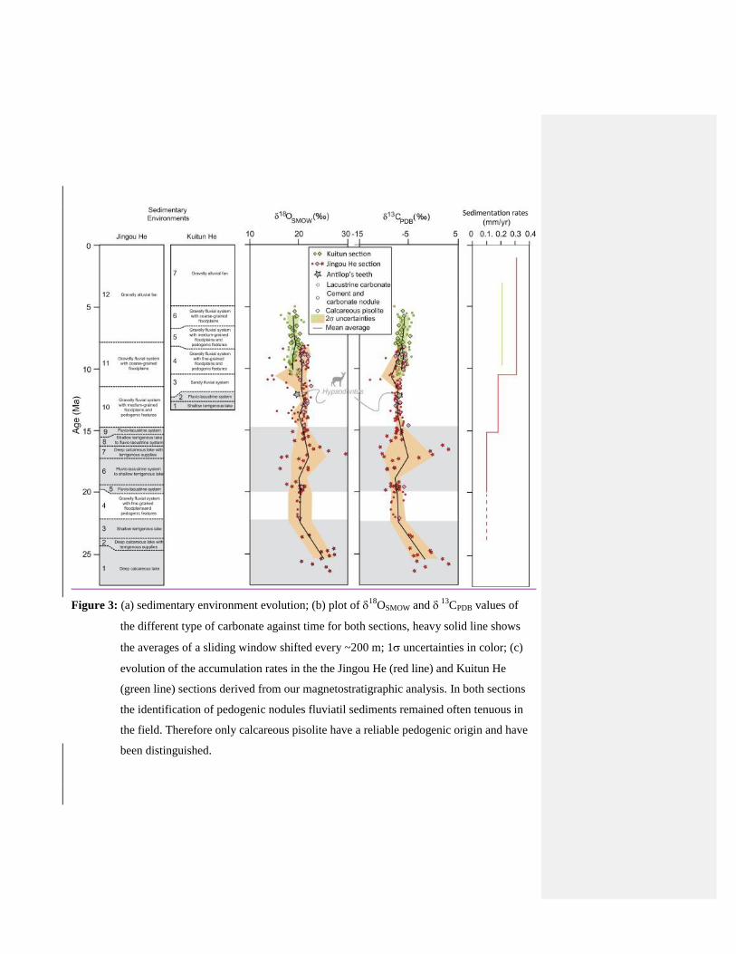
Figure 3: (a) sedimentary environment evolution; (b) plot of 18
OSMOW and 13
CPDB values of
the different type of carbonate against time for both sections, heavy solid line shows
the averages of a sliding window shifted every ~200 m; 1 uncertainties in color; (c)
evolution of the accumulation rates in the the Jingou He (red line) and Kuitun He
(green line) sections derived from our magnetostratigraphic analysis. In both sections
the identification of pedogenic nodules fluviatil sediments remained often tenuous in
the field. Therefore only calcareous pisolite have a reliable pedogenic origin and have
been distinguished.
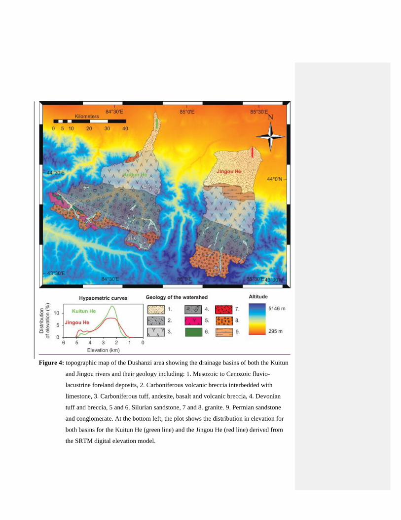
Figure 4: topographic map of the Dushanzi area showing the drainage basins of both the Kuitun
and Jingou rivers and their geology including: 1. Mesozoic to Cenozoic fluvio-
lacustrine foreland deposits, 2. Carboniferous volcanic breccia interbedded with
limestone, 3. Carboniferous tuff, andesite, basalt and volcanic breccia, 4. Devonian
tuff and breccia, 5 and 6. Silurian sandstone, 7 and 8. granite. 9. Permian sandstone
and conglomerate. At the bottom left, the plot shows the distribution in elevation for
both basins for the Kuitun He (green line) and the Jingou He (red line) derived from
the SRTM digital elevation model.

Figure 5: 18
OSMOW and a 13
CPDB values and lithology (grain size) plotted against interpreted
depositional environments and their interpreted aridity. Circles correspond to
carbonate cement while their size and color show the samples lithology. Blue scare are
carbonate mudstone sampled in lacustrine deposits while the blue diamond represent
the pedogenic carbonate samples. Below each column is given the average isotopic
values (in ‰) measured in each of the interpreted depositional environment.
Mis en forme : Anglais (États Unis)

Section n δ18OMeteoric Water (SMOW; %)
5 10 15 20 25 30
(°C) (°C) (°C) (°C) (°C) (°C)
Kuitun He 67 −14.2±0.8 −12.7±0.8 −11.5±0.8 −10.4±0.8 −9.3±0.8 −8.3±0.8
Jingou He 117a −12.8±2.4 −11.6±2.4 −10.4±2.4 −9.3±2.4 −8.2±2.4 −7.2±2.4
a
Only samples from fluvial system.

Table 1: average 18
OMeteoric Water (SMOW; ‰) values for both section calculated based on the average
18
Ocarbonate (SMOW) values and supposed crystallization temperature ranging from 5°C
to 30°C. n is the number of sample used to average the 18
Ocarbonate (SMOW) which
exclude lacustrine samples for the Jingou He section.
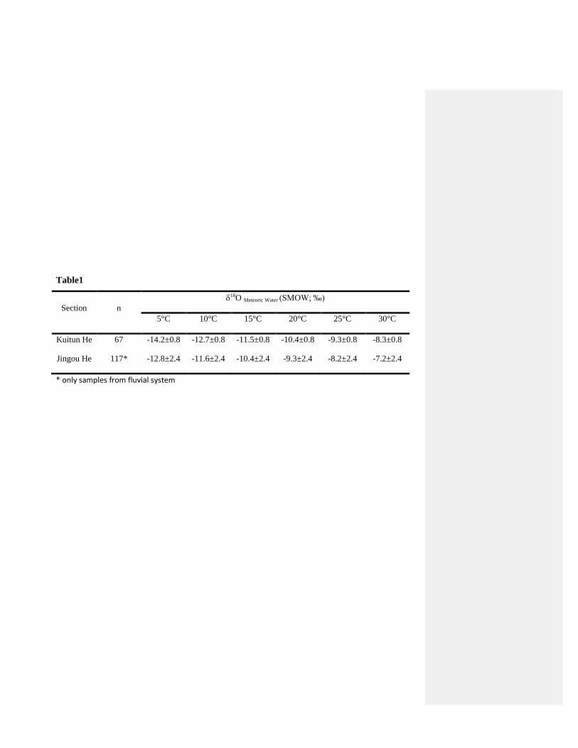
Table1
Section n
18O Meteoric Water (SMOW; ‰)
5°C 10°C 15°C 20°C 25°C 30°C
Kuitun He 67 -14.2±0.8 -12.7±0.8 -11.5±0.8 -10.4±0.8 -9.3±0.8 -8.3±0.8
Jingou He 117* -12.8±2.4 -11.6±2.4 -10.4±2.4 -9.3±2.4 -8.2±2.4 -7.2±2.4
* only samples from fluvial system