a management plan for the flood meadows, alton, … meadows man plan with work... · one such...
TRANSCRIPT
A Management Plan for the
Flood Meadows, Alton,
Hampshire.
John Underhill-Day & Chris Panter

2
Footprint Contract Reference: 409
Date: November 2017
Version: Final
Recommended Citation: Underhill-Day, J. C. & Panter, C., 2017. A Management Plan for Alton Flood
Meadows, Alton, Hants. Unpublished Report to Alton Town Council.
F O O T P R I N T E C O L O G Y , F O R E S T O F F I C E , B E R E
R O A D , W A R E H A M , D O R S E T B H 2 0 7 P A
W W W . F O O T P R I N T - E C O L O G Y . C O . U K
0 1 9 2 9 5 5 2 4 4 4

3
Contents
Contents ........................................................................................... 3
Acknowledgements ....................................................................... 4
1. Site description and physical features .............................. 5
2. A vision for the Flood meadows ..................................... 11
3. Actions under each objective .......................................... 12
Objective 1- Maintain the amenity grassland as a safe and pleasant
environment for quiet recreation ......................................................... 12
Rationale ...................................................................................................... 12
Actions ......................................................................................................... 12
Objective 2 Maintain the existing tree and shrub cover ......................... 12
Rationale ...................................................................................................... 12
Actions ......................................................................................................... 12
Objective 3- Maintain the watercress beds to maximise their biodiversity
and educational value ........................................................................... 13
Rationale ...................................................................................................... 13
Actions ......................................................................................................... 13
Objective 4 Maintain and improve signage and interpretation ............ 14
Rationale ...................................................................................................... 14
Actions ......................................................................................................... 14
Objective 5 Maintain and improve access ............................................... 14
Rationale ...................................................................................................... 15
Actions ......................................................................................................... 15
Objective 6 Maintain liaison with the local community, individuals and
organisations .......................................................................................... 15
Rationale ...................................................................................................... 15
Actions ......................................................................................................... 15
Objective 7 Carry out a programme of survey and monitoring ............ 16
Rationale ...................................................................................................... 16
Actions ......................................................................................................... 16
Objective 8 Carry out all statutory duties as site owner ........................ 16
Rationale ...................................................................................................... 16

4
Actions ......................................................................................................... 16
Objective 9 Seek resources to carry out the prescriptions in the
management plan .................................................................................. 16
Rationale ...................................................................................................... 16
Actions ......................................................................................................... 16
4. Work Programme ............................................................... 17
Notes. .......................................................................................................... 17
5. Appendix 1 ........................................................................... 21
6. Appendix 2 ........................................................................... 24
Acknowledgements
We are grateful to Leah Coney who has given us support and assistance throughout this project, to the
Steering Group for their helpful advice and guidance, and particularly to Dr June Chatfield for giving so freely
of her knowledge and expertise.

5
1. Site description and physical features
Location
The Alton Flood Meadows lie on the western edge of the town of Alton (Grid Ref
SU712394), located a few hundred metres downstream from the source of the River Wey,
and the river forms the southern boundary of the site. The remaining edges of the site are
bounded by residential properties (Greenfields estate to the north), private land, and
school playing fields. The area of the site is approximately 6.4 ha.
Tenure
The site is owned by Alton Town Council. The area of grassland to the south of the River
Wey, at the corner of Lenten Street/Basingstoke Road and New Odiham Road, is owned by
the local water company (and includes ownership of both banks of the River Wey along this
field).
Other rights
There are a number of public rights of way which cross the site (shown in the map below).
All these public rights of way are footpaths, although many no longer coincide with the
site’s formal paths.
Designations
6
The Flood Meadows lie partially within Alton’s Town Centre Conservation Area, but
otherwise there are no formal nature conservation designations. In the Conservation Area
Plan, Flood Meadows are recognised to provide important vistas and character to the Town
Centre. They are also designated in the Alton Neighbourhood Plan as a local green space
where development will not be permitted, other than in very special circumstances.
Furthermore, they are arguably the largest area of ‘semi-natural’ amenity land in the Town
centre.
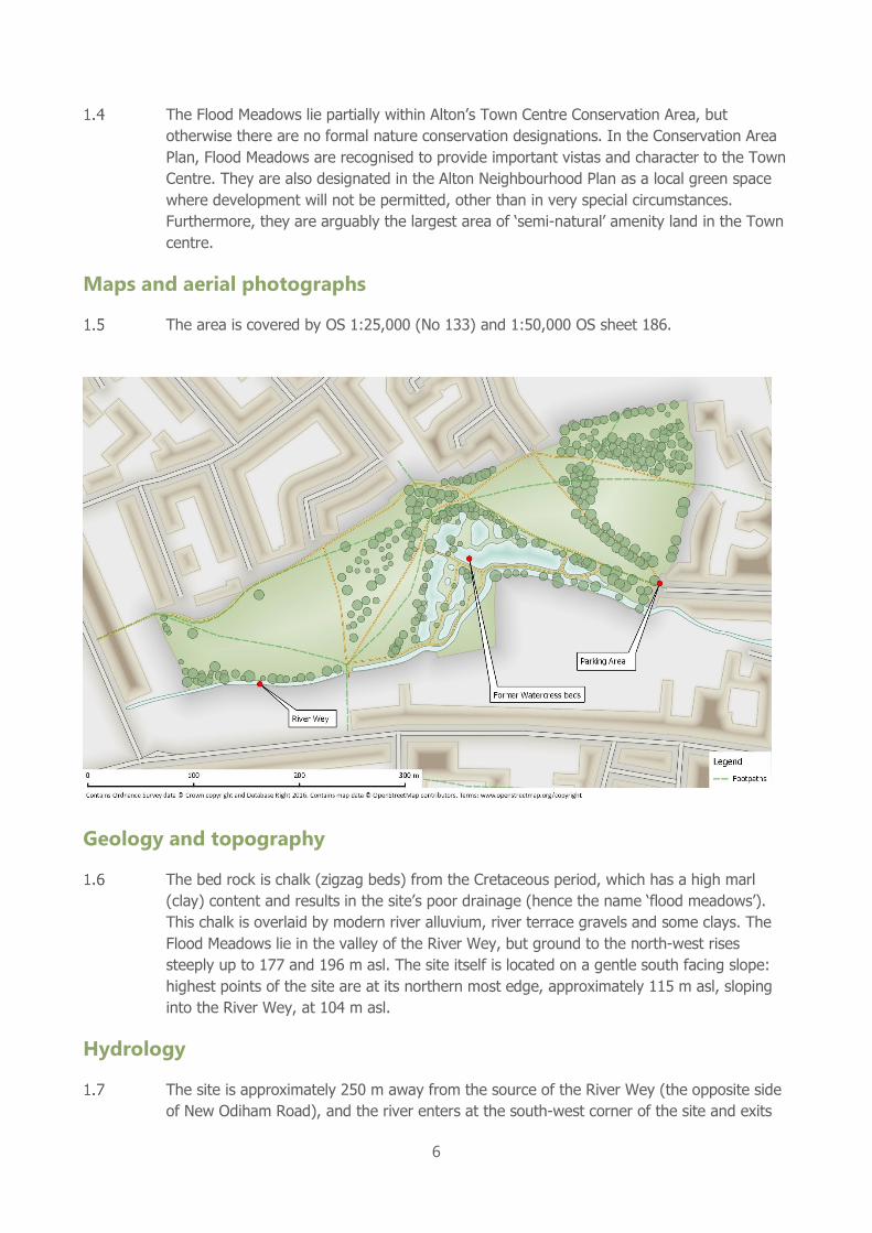
Maps and aerial photographs
The area is covered by OS 1:25,000 (No 133) and 1:50,000 OS sheet 186.
Geology and topography
The bed rock is chalk (zigzag beds) from the Cretaceous period, which has a high marl
(clay) content and results in the site’s poor drainage (hence the name ‘flood meadows’).
This chalk is overlaid by modern river alluvium, river terrace gravels and some clays. The
Flood Meadows lie in the valley of the River Wey, but ground to the north-west rises
steeply up to 177 and 196 m asl. The site itself is located on a gentle south facing slope:
highest points of the site are at its northern most edge, approximately 115 m asl, sloping
into the River Wey, at 104 m asl.
Hydrology
The site is approximately 250 m away from the source of the River Wey (the opposite side
of New Odiham Road), and the river enters at the south-west corner of the site and exits

7
at the south-east corner, forming the entire southern boundary of the site. The river is
mostly fed by springs from the chalk and is therefore alkaline and base rich.
This close to the source, surface water flow is not a permeant feature with the stream
usually drying up in the summer and autumn. The stream is considered mostly
winterbourne, but the presence of flow is still variable both in timing and duration. One
factor in this is that flow is also supplemented by surface water run-off from local
agricultural fields, adjacent grasslands, housing and road drainage.
Just under one hectare of the Flood Meadows is the wetland area of the former watercress
beds, which is now mostly marshland and will attempt to succession into wet
woodland/carr. In this area there is almost always surface water, retained by the structures
and fed by an additional spring. This spring provides additional indirect water input and
results in a more consistent, but nevertheless variable flow downstream of this point.
In the 1980s and 1990s this section of the river could be dry for almost two thirds of the
year, including one period when it was dry for 18 months. Water abstraction at the source
of the Wey was therefore halted in 2003, however water flows will still fluctuate.
Soils and Vegetation
The soils which overlay the chalk are mostly river alluvium, with some clays, so although
the river water is calcareous the grassland does not provide a chalk grassland flora.
The most botanically interesting parts of the site are located in the river and wetland areas
of the former watercress beds. There are several species of aquatic plants, many of which
are indicative of calcareous streams. The aquatics include: watercress, fool’s watercress,
brooklime, starwort and water crow-foot (see appendices for a species list). The former
watercress beds include lots of open water, with abundant sedges, reed sweet-grass and
some reed, but also great willowherb, water mint and water forget-me-not. A recent
investigation by the Environment Agency suggests the River Wey itself is failing for
invertebrates and macrophytes due to a lack of river morphology (resulting from
realignment and past over abstraction), shading by trees, silting up and a lack of woody
debris.
The grassland areas of the site were previously riverside grazing pasture. Any grazing or
farming management ceased almost 60 years ago and since then has been maintained
primarily as recreational open space. The regular mowing to provide suitable amenity
grassland means it has relatively little botanical interest, other than some clovers, yellow
composites and black medick. Areas of grassland have been mown much more infrequently
to provide ‘conservation grassland’ areas. The invasive Japanese knotweed occurred by
Netherfield Close and is therefore monitored for.
Trees around the watercress beds include horse chestnut, alder, willow and yew. Other
trees are scattered throughout much of the rest of the site (often sycamore or oak); with a
few clear woodland blocks and a tree lined avenue. There are also a number of memorial
plantings by locals as part of a “Trees for Life” project.
Fauna

8
A range of common bird species occur including breeding wrens, finches, tits, and species
of rivers and wetland such as moorhen and kingfisher. Other vertebrates on the site,
include water shrew, bats, palmate and smooth newt, and common frog (terrapins, which
do occur in King’s Pond, are not believed to be present)
No systematic surveys have been undertaken on the invertebrates, but a number of casual
records are noted in the records of the Alton Natural History Society. The aquatic
invertebrate fauna would appear to be rich and may indicate good water quality in the
watercress beds. The mollusc fauna is particularly rich (at least 27 species in 1984 – see
appendices), with the watercress beds supporting good populations of snails, which benefit
from the calcareous waters. One such species, Ashford’s hairy snail, a species of local
occurrence in Hampshire, is present in good numbers.
History
The earliest known history of the site was as agricultural fields associated with the former
Amery Farm (the farm buildings nearby have been converted to residential properties). The
farm would have had mixed arable and pastoral land, but the fields of the current Flood
Meadows site were thought to have been used for rough grazing. The watercress beds
would have been part of the farm and would have been well managed to provide a good
income for the farm. The public right of way from Shaldon to Alton would have existed at
this point in time and historical evidence shows there was informal recreational use of the
fields and river by families.
Postcard of the view of Flood Meadows estimated to around 1895-1905 (Postcard produced 1905)
9
In the late 1960s Amery Farm was sold and divided up, with large parts of the farm
developed for housing (e.g. the Greenfields estate). At this point the area now known as
Flood Meadows was given to East Hampshire District Council to provide greenspace as part
of a S106 agreement. It is around this time, or possibly a few years prior to the sale of the
site, that the watercress beds were abandoned. The water company also bought some of
the land, which included the watercress beds, but these were also later conveyed to the
local authority.
The current site owners, Alton Town Council, acquired the site from East Hampshire
District Council in 2004. The site is managed by the local team, with help from local
volunteers.
Historical events at the site, include the Battle of Alton (1643) in the English Civil War and
the murder of Fanny Adams (1867).
Archaeology
While the site clearly has a historic interest, there are no Scheduled Ancient Monuments or
known archaeological features on the site.
Public Access and use
As has already been noted, the site has a long history of recreational use by the public,
even before it was a formal public open space (1896 maps indicate a footpath running east
to west across the site). Currently, there are approximately six public rights of way which
criss-cross the site, although these sometimes no longer coincide with the formal surfaced
paths. There is one formal parking area immediately adjacent to site (off Tanhouse Lane,
c. 5 spaces), and a large number of foot access points.
There are around 10 access points onto the site. These are: from the south off Basingstoke
Road/Lenten Street, the east from Tanhouse Lane and Cromwell Gardens, the west off
New Odiham Road (all PROW). Access from the north is more diffuse with most roads in
the Greenfields estate terminating in access to the Flood Meadows (e.g. Netherfield Close,
Wentworth Gardens, Willoughby Close and Brandon Close).
The surfaced paths were mostly constructed when the Greenfields estate was built in the
early 1970s. Over the years there has been some repair of individual paths, but the quality
of many of the hard surfaced paths (mostly tarmacked) has deteriorated in recent years,
due to material breaking up, vegetation encroachment and flooding. This greatly reduces
the accessibility of the site for certain user groups. Future plans for a River Wey walk
proposed by the Town Council would promote some access paths and provide
improvements to these paths.
In 2015 a public consultation was undertaken by the Town Council, with residents asked to
complete a questionnaire. Eighty-four responses were received by the Council and showed
interesting results. Approximately three quarters (73%) of the respondents were over 55
and most visit the site when accompanied by partners, friends or children. Of those
completing the questionnaire, 42% visited daily, and 91% said they would spend up to an

10
hour on the site. The results show many respondents walk through the site (69%), e.g. en
route to other places or facilities (but may also be conducting other activities, such as dog
walking) and 38% said they were utilising the open space only for dog walking. Residents
suggested the usage of the space had changed, with fewer families using the area as a
recreational space. There were concerns dog fouling was an issue, as were incidents of
dogs disturbing wildlife.
Past management
In the early days of the Flood Meadows, EDHC maintained the site as amenity grassland, in
using ‘playing field’ style management. However in the 1980s local residents (eventually
the Alton Society’s Environment Group), highlighted the site could be managed much more
sympathetically, producing benefits for wildlife and people. This led to areas of grassland
maintained as ‘conservation grassland’ (e.g. cut only twice a year), rather than the rest of
the site which is subject to regular cutting to maintain its appearance as amenity
grassland. The Alton Society Environment Group conducted much of the volunteer work,
including the memorial planting (which ceased in 1997).
Management is carried out by Grounds Team of Alton Town Council and volunteers. The
conservation grassland areas are mown and cuttings heaped at the southern edge of the
site to be used for mulching around the memorial “Trees for Life”. Work includes
management of the former watercress beds to clear scrub and reduce succession to wet
woodland/carr.
This work has been supported by a recent project led by the Surrey Wildlife Trust to help
improve parts of the River Wey for flood defence and biodiversity. The work of the Wey
Landscape Partnership Catchment Partnership Action Fund has included specific actions
along the River Wey in Flood Meadows, including removal and repositioning of silt,
coppicing of riverside trees to increase light, and placement of deflectors and woody debris
to increase channel morphology and create invertebrate habitat,

11
2. A vision for the Flood meadows
In 25 years’ time, the Flood Meadows will be much valued and heavily used by the local
community for quiet recreation, who will also participate in caring for it and in protecting its
amenity and wildlife features. The path network and other facilities will be safe and well
maintained and areas of grassland have been successfully restored to flower rich meadows.
The mature trees, scrub and woodland and more recent native plantings will be thriving
and will contribute to a pleasant landscape and support a varied bird and invertebrate
community. The River Wey and former watercress beds remain a sanctuary for a rich and
diverse flora and fauna, with all the successional features from open water to wet
woodland well represented and available for visitors, particularly educational groups, to
view and study with minimal disturbance.

12
3. Actions under each objective
Objective 1- Maintain the amenity grassland as a safe and
pleasant environment for quiet recreation
Rationale
The Flood Meadows is a “little bit of countryside in the town” - the open grassland
contributes to this concept and is the main open element of the site used by visitors and
their pets. Maintaining this area and improving its visual attractiveness and interest for
visitors is an important part of the site management.
Actions
1. Cut the grass as required, maintaining both long and short grass regimes and remove most grass cuttings off site.
2. Investigate and carry out a pilot project to create an area of flower rich meadow, and if successful, extend to larger areas
3. Maintain amenity tree plantings and continue to mulch the less mature ‘Trees for life’ with grass cuttings from the site. Cuttings used as mulch to be well dried beforehand to reduce the likelihood of contamination by mould
4. Check all amenity trees annually for safety and take appropriate action 5. Continue to encourage dog walkers to pick up after their pets
Objective 2 Maintain the existing tree and shrub cover
Rationale
The existing trees and shrubs are an important part of the landscape of the Flood Meadows
site and provide interest and shade for visitors and cover for wildlife. However, disease,
storm damage and old age all need to be considered so long-term maintenance and
replacement will need to be planned for.
Actions
1. Carry out a tree survey and produce a strategy for: a. maintaining and when necessary replacing existing mature trees
which have to be felled for Health & Safety reasons
b. carrying out new planting to improve the landscape
c. including a long-term plan for replacing trees affected by disease
(mainly ash and horse chestnut)
2. Leave a selection of large felled dead wood on site to support invertebrates and other wildlife
3. New plantings to be native species only which already occur in the neighbourhood 4. Maintain existing areas of old hedge and scrub along the line of the river and above the
watercress beds

13
5. Plant additional scrub as an understorey to the riverside trees by the Tanhouse Lane entrance to provide cover for breeding and foraging birds
Objective 3- Maintain the watercress beds to maximise their
biodiversity and educational value
Rationale
The old watercress beds are a historic feature of the site and a valuable wildlife and
educational resource. The beds are fed by chalk springs and eventually discharge into the
River Wey which is also derived from chalk springs. Chalk streams are an internationally
rare habitat with only some 200 chalk streams in the world, and 85% of these in the UK,
making them a Biodiversity Action Plan (BAP) Priority Habitat. However, to avoid the beds
being colonised by trees and scrub and becoming impenetrable wet woodland,
management is needed to retain open water and a range of wetland habitats. The primary
aim here is to maintain the wildlife interest of the beds and to encourage educational
activities and quiet enjoyment by visitors.
Actions
1. Produce and implement a management strategy for the watercress beds which determines the proportions of the beds to be maintained as: open water, sedge and water grass beds and willow scrub
2. Set aside areas close to the beds and away from public view for depositing and drying out sedge and grass debris cleared from the beds to provide hibernacula for amphibians, breeding sites for grass snakes etc.
3. Carry out vegetation clearances moving from the springs downstream 4. Obtain costs for carrying out vegetation and silt clearance using contractors. 5. Any use of contractors should maintain stringent precautions against contamination by
alien invasive plants 6. Monitor wetland areas and river for invasive alien plants and take immediate actions to
remove any infestation 7. Clear willow growth over open water on alternate sides of open water areas every 5-10
years 8. Repopulate the new berms near the source of the river with iris from further
downstream in the watercress beds 9. Rationalise footpath network through watercress beds to reduce disturbance and
establish a quiet sanctuary area for wildlife 10. Provide a pond dipping platform and viewing platform overlooking the beds 11. Consult with the Hampshire and Isle of Wight Wildlife Trust on the production and
implementation of an overall wildlife conservation, education and access management strategy for the water cress beds to be used as a vehicle for approvals and fund raising

14
Objective 4 Maintain and improve signage and interpretation
Rationale
Enjoyment and knowledge of the site is assisted by the provision of on-site information and
educational material. The Flood Meadows are also an ideal location for local events and for
encouraging community engagement.
Actions
1. Maintain existing signs at main entrances but add “Welcome to Flood Meadows” wording as appropriate.
2. At main site entrances ask visitors to keep their dogs under control and at the entrances to the water cress beds consider installing wildlife sanctuary signs and ask visitors to put their dogs on leads.
3. Produce a colour guide to the Flood Meadows and make available through local outlets, inserts to newsletters, letter drops to new and existing residents etc.
4. Illustrate and update existing nature trail guide and make available to local schools, visiting groups etc.
5. Set up (or use existing) social media accounts, e.g. Facebook groups, to inform the public about the site, events, recruit volunteers etc.
6. Consider the use of beacons and interactive signage 7. Consider commissioning additional interpretative signs on the wildlife of the water cress
beds 8. Consider putting information on the history of the area on the Council website
Objective 5 Maintain and improve access
15
Rationale
The Flood Meadows are an important local amenity with all-the-year-round visiting by
walkers, dog walkers and children. Access points on the perimeter of the site and paths
across it need to be maintained in a safe and usable condition.
Actions
1. Maintain all existing site entrances in safe condition 2. Improve the unsightly entrance at Lenten Street 3. Introduce an extra informal path from the footpath from New Odiham Rd to meet the
entrance at Lenten Street 4. Prepare a 5-year footpath maintenance and improvement programme for the path
network in accordance with the path management plan with priority given to repairing the erosion to the riverside path
5. Maintain and improve the seating and other infrastructure 6. Give consideration to the installation of street lights at a small number of main path
junctions
Objective 6 Maintain liaison with the local community,
individuals and organisations
Rationale
The Flood Meadows are an important local amenity, with many local individuals and
organisations taking a keen interest in its management and condition. This brings with it a
sense of ownership by the local community and it is important that this is recognised and
that a broad consensus is reached on how the site is used and managed. It is also
important to liaise with the official bodies with duties and responsibilities relevant to the
site.
Actions
1. Liaise with local community, neighbours and user groups to maintain local contact and encourage local engagement
2. Liaise with the Weywalk Project particularly over the riverside path by the watercress beds and improvements to the Lenten street entrance
3. Liaise with the Environment Agency over works to improve the River Wey where it passes through the Flood Meadows; over the quantity and quality of water in the upper reaches of the Wey; and the maintenance and improvement of water levels and of the springs in the water cress beds
4. Liaise with Town Council/Steering Group to plan, finance and carry out management having regard for the Neighbourhood Plan and new Conservation Area, monitor the progress of the management plan, enforce the bylaws, report urgent works etc.
5. Maintain a record of incidents such as anti-social behaviour, vandalism etc. and liaise with the local police and emergency services as necessary
6. Maintain contact with local and county natural history groups and individual experts for management advice
7. Liaise with developer, Redrow, building houses near the source of the river.

16
Objective 7 Carry out a programme of survey and monitoring
Rationale
To assess the results of current and future management and the changing use and interest
of the Flood Meadows it is essential to put in place a monitoring programme which will
collect information on aspects of the site and its use by visitors.
Actions
1. As finances allow, carry out a visitor survey at intervals of 10 years 2. Set up a recording website where visitors can record their natural history sightings 3. Encourage wildlife surveys by outside experts or groups and store the results for
reference 4. Encourage volunteer recorders for particular groups 5. Examine the need for use of special data software to hold collected information for the
site
Objective 8 Carry out all statutory duties as site owner
Rationale
As site owner, the Town Council are obliged to meet their statutory obligations.
Actions
1. Carry out regular health and safety checks 2. Obtain all statutory consents and approvals necessary for carrying out management
work
Objective 9 Seek resources to carry out the prescriptions in the
management plan
Rationale
The activities described in this management plan will need to be financed and additional
resources will need to be found
Actions
1. Investigate possible sources of funding including statutory bodies, private charities, waste management companies etc.
17
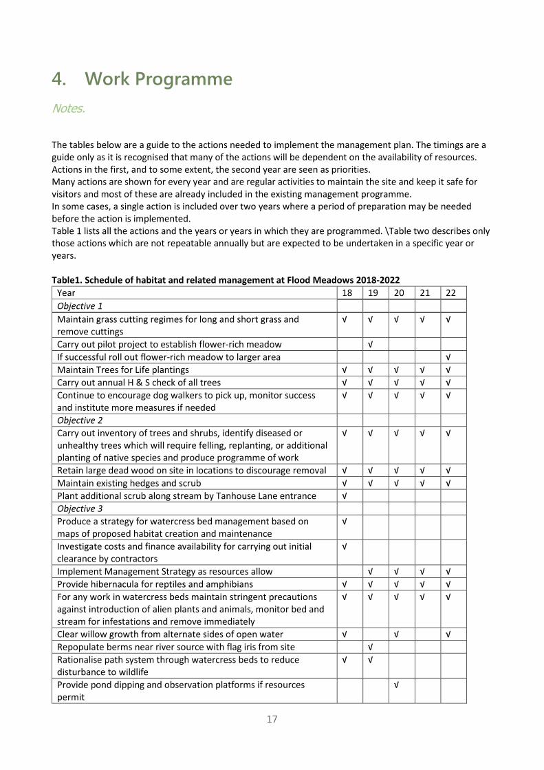
4. Work Programme
Notes.
The tables below are a guide to the actions needed to implement the management plan. The timings are a
guide only as it is recognised that many of the actions will be dependent on the availability of resources.
Actions in the first, and to some extent, the second year are seen as priorities.
Many actions are shown for every year and are regular activities to maintain the site and keep it safe for
visitors and most of these are already included in the existing management programme.
In some cases, a single action is included over two years where a period of preparation may be needed
before the action is implemented.
Table 1 lists all the actions and the years or years in which they are programmed. \Table two describes only
those actions which are not repeatable annually but are expected to be undertaken in a specific year or
years.
Table1. Schedule of habitat and related management at Flood Meadows 2018-2022
Year 18 19 20 21 22
Objective 1
Maintain grass cutting regimes for long and short grass and
remove cuttings
√ √ √ √ √
Carry out pilot project to establish flower-rich meadow √
If successful roll out flower-rich meadow to larger area √
Maintain Trees for Life plantings √ √ √ √ √
Carry out annual H & S check of all trees √ √ √ √ √
Continue to encourage dog walkers to pick up, monitor success
and institute more measures if needed
√ √ √ √ √
Objective 2
Carry out inventory of trees and shrubs, identify diseased or
unhealthy trees which will require felling, replanting, or additional
planting of native species and produce programme of work
√ √ √ √ √
Retain large dead wood on site in locations to discourage removal √ √ √ √ √
Maintain existing hedges and scrub √ √ √ √ √
Plant additional scrub along stream by Tanhouse Lane entrance √
Objective 3
Produce a strategy for watercress bed management based on
maps of proposed habitat creation and maintenance
√
Investigate costs and finance availability for carrying out initial
clearance by contractors
√
Implement Management Strategy as resources allow √ √ √ √
Provide hibernacula for reptiles and amphibians √ √ √ √ √
For any work in watercress beds maintain stringent precautions
against introduction of alien plants and animals, monitor bed and
stream for infestations and remove immediately
√ √ √ √ √
Clear willow growth from alternate sides of open water √ √ √
Repopulate berms near river source with flag iris from site √
Rationalise path system through watercress beds to reduce
disturbance to wildlife
√ √
Provide pond dipping and observation platforms if resources
permit
√

18
Year 18 19 20 21 22
Investigate with Wildlife Trust involvement in management and
educational strategy for watercress beds to also assist with fund
raising initiatives
√ √
Objective 4
Maintain/improve/replace/add to existing signage, including
consideration of the use of beacons, interactive signage
√ √ √ √ √
Produce a colour guide to Flood meadows and promote circulation
and availability
√ √ √ √
Illustrate and update nature trail guide and make available to
educational and other groups
√
Use social media to make available information about the Flood
Meadows including newsletter, events etc.
√ √ √ √ √
If resources allow consider commissioning interpretation panels
for watercress beds
√
Use council website for information on history, events,
volunteering etc. on Flood meadows
√ √ √ √ √
Objective 5
Carry out improvements to Lenten Street entrance √ √
Maintain all entrances as safe, clean and welcoming √ √ √ √ √
Introduce additional informal path from New Odiham Road to
Lenten Street entrance
√ √
Prepare a five-year maintenance programme for paths √
Implement path strategy as resources allow √ √ √ √ √
Maintain and improve seating and other infrastructure √ √ √ √ √
Investigate provision of street lighting in limited areas √
Install street lighting if resources allow √
Objective 6
Liaise with neighbours, user groups, the Weywalk Project, and
other stakeholders on management and use of the Flood Meadows
√ √ √ √ √
Liaise with EA over monitoring, maintenance and improvement of
water quality and levels in watercress beds and river
√ √ √ √ √
Liaise with Town Council Steering Group over progress of
management plan, enforcement of bylaws, urgent works and other
matters for the management of the site
√ √ √ √ √
Liaise with emergency services and keep a record of incidents at
the site
√ √ √ √ √
Maintain contacts with experts and groups for advice on aspects of
management
√ √ √ √ √
Liaise with Redrow over local housebuilding and the effects on the
use and management of Flood Meadows
√ √ √
Objective 7
Carry out a visitor surveys every ten years if finances allow √
Set up recording website √
Encourage outside experts/volunteers to carry out
surveys/monitoring
√ √ √ √ √
Encourage volunteer records for particular groups √ √ √ √ √
Review the need for dedicated software to hold site records √
Objective 8

19
Year 18 19 20 21 22
Obtain all necessary statutory consents and approvals for
management work
√ √ √ √ √
Carry out regular H & S checks of site √ √ √ √ √
Objective 9
Investigate sources of funding for management work, surveys and
monitoring
√ √ √ √ √
Table 2 Actions by year excluding annually repeated actions
Year 18 19 20 21 22
Objective 1
Carry out pilot project to establish flower-rich meadow √
If successful roll out flower-rich meadow to larger area √
Objective 2
Plant additional scrub along stream by Tanhouse Lane entrance √
Objective 3
Produce a strategy for watercress bed management based on maps of
proposed habitat creation and maintenance √
Investigate costs and finance availability for carrying out initial clearance
by contractors √
Implement Management Strategy as resources allow √ √ √ √
Clear willow growth from alternate sides of open water √ √ √
Repopulate berms near river source with flag iris from site √
Rationalise path system through watercress beds to reduce disturbance
to wildlife √ √
Provide pond dipping and observation platforms if resources permit √
Investigate with Wildlife Trust involvement in management and
educational strategy for watercress beds to also assist with fund raising
initiatives
√ √
Objective 4
Produce a colour guide to Flood meadows and promote circulation and
availability √ √ √ √
Illustrate and update nature trail guide and make available to educational
and other groups √
If resources allow consider commissioning interpretation panels for
watercress beds √
Objective 5
Carry out improvements to Lenten Street entrance √ √
Introduce additional informal path from New Odiham Road to Lenten
Street entrance √ √
Prepare a five-year maintenance programme for paths √
Investigate provision of street lighting in limited areas √
Install street lighting if resources allow √
Objective 6

20
Liaise with Redrow over local housebuilding and the effects on the use
and management of Flood Meadows √ √ √
Objective 7
Carry out a visitor surveys every ten years if finances allow √
Set up recording website √
Review the need for dedicated software to hold site records √

21
5. Appendix 1
Species list for the list from 1984. Plants and molluscs only (most extensively studied group)
Taxon Name Common Name
Aesculus hippocastanum Horse Chestnut
Crataegus monogyna Hawthorn
Fraxinus excelsior Ash
Salix capraea Goat Willow/Sallow
Salix cinerea Grey Willow
Salix fragilis Crack Willow
Taxus baccata Yew
Ulmus procera Elm
Achillea millefolium Yarrow
Aegopodium podagraria Ground Elder
Agrostis stolonifera Creeping Bent
Alopecurus geniculatus Marsh Foxtail
Anthriscus sylvestris Cow Parsley
Apium nodiflorum Fool’s water-cress
Arctium lappa Greater Burdock
Artemisia vulgaris Mugwort
Callitriche Starwort
Calystegia sepium Hedge Bindweed
Capsella bursa-pastoris Shepard’s-purse
Cirsium arvense Creeping Thistle
Cirsium vulgare Common Spear Thistle
Dactylis glomerata Cock's-foot
Elytrigia repens Common Couch
Ficaria verna Lesser Celandine
Geranium dissectum Cut-leaved Crane's-bill
Glechoma hederacea Ground Ivy
Glyceria maxima Reed Sweet-grass
Glyceria notata Plicate Sweet-grass
Hedera helix Ivy
Heracleum sphondylium Hogweed
Holcus lanatus Yorkshire-fog
Hypericum perforatum Common St. John's Wort
Impatiens glandulifera Himalayan Balsam
Iris pseudacorus Yellow Iris
Lamium album White Dead-nettle
Lemna trisulca Ivy-leaved Duckweed
Lolium perenne Perennial Rye-grass
Matricaria discoidea Pineappleweed
Mentha aquatica Water Mint
Myosotis scorpioides Common Water Forget-Me-Not

22
Phalaris canariensis Canary-grass
Phleum bertolonii Smaller Cat’s-tail
Phragmites australis Common Reed
Plantago major Greater Plantain
Poa palustris Swamp Meadow-grass
Polygonum aviculare Knotgrass
Ranunculus bulbosus Bulbous Buttercup
Ranunculus repens Creeping Buttercup
Rorippa nasturtium-aquaticum Water-cress
Rubus idaeus Raspberry
Rumex acetosa Common Sorrel
Rumex obtusifolius Broad-leaved dock
Rumex sanguineus Wood Dock
Scrophularia auriculata Water Figwort
Senecio jacobaea Common Ragwort
Sisymbrium officinale Hedge mustard
Sium latifolium Greater water-parsnip
Solanum dulcamara Bittersweet
Sonchus asper Prickly Sow-thistle
Sparganium sp. Bur-Reed
Stachys sylvatica Hedge Woundwort
Stellaria media Common Chickweed
Taraxacum officinale Dandelion
Trifolium campestre Hop Trefoil
Trifolium repens White Clover
Tussilago farfara Colt's-foot
Typha latifolia Great Reedmace
Urtica dioica Stinging Nettle
Veronica anagallis-aquatica Blue Water-speedwell
Veronica beccabunga Brooklime
Veronica catenate x anagallis-
aquatica Hybrid Speedwell
Vicia sepium Bush Vetch
Phyllitis scolopendrium Hart's-tongue
Eurhynchium praelongum Common Feather-moss
Brachythecium rutabulum Rough-stalked Feather-moss
Aegopinella nitidula Smooth Glass Snail
Anisus (Disculifer) vortex Whirlpool Ramshorn
Arion (Kobeltia) distinctus Brown Soil Slug
Arion (Mesarion) subfuscus Dusky Slug
Arion ater agg. Large Black Slug
Arion silvaticus

23
Ashfordia granulata Silky Snail (Ashford’s Hairy Snail)
Bathyomphalus contortus Twisted Ramshorn
Cepaea hortensis White-lipped Snail
Clausilia (Clausilia) bidentata Two-toothed Door Snail
Cochlicopa cf. lubrica Slippery Moss Snail
Cornu aspersum Common Garden Snail
Deroceras (Deroceras) reticulatum Netted Field Slug
Discus (Gonyodiscus) rotundatus Rounded Snail
Lymnaea (Stagnicola) palustris Marsh Pond Snail
Monacha (Monacha) cantiana Kentish Snail
Oxychilus (Oxychilus) cellarius Cellar Snail
Oxyloma (Oxyloma) elegans Pfeiffer's Amber Snail
Pisidium casertanum A Pea Mussel
Pisidium milium Rosy Pea Shell
Pisidium obtusale Porous Pea Mussel
Pisidium personatum Red-crusted Pea Mussel
Radix balthica Wandering Snail
Trochulus (Trochulus) hispidus Hairy Snail
Trochulus (Trochulus) striolatus Strawberry Snail
Valvata cristata Flat Value Snail
Vitrina pellucida Winter Semi-slug

24
6. Appendix 2
Here follows a report by I. D. Watts, 5th March 2015. “Flood Meadows – My suggestions for
improvements” (Report for the attention of Matthew Bayliss, Open Spaces Committee member)
While this report is not part of the management plan, and is solely the views of I.D. Watts, it
should be considered as a the most comprehensive description available of the facilities on the
sites to form the starting point for addressing some of the issues regarding accessibility on the
site.
Overview.
I have completed a questionnaire as requested but feel there is a need to expand my reply.
I have lived adjacent to flood meadows since 1979 and have walked our dog here for the last nine years on a
daily basis. In this time I have observed many things that I believe should have been done over the years,
many of these involving considerable expense, and because of this I have not raised them before as funding
is always a problem.
I have experience in the type of work needed to restore and improve flood meadows so have used this to
provide this document for your use and hope that it will enable you to see some of the problems that I see
needing attention so the facility is upgraded and made as maintenance free as possible so future funding on
maintenance is kept to a minimum.
I worked for the HCC roads & bridges dept. for some 12 years on the following types of work, roads,
footpaths & retaining walls and 10 of these years building and maintaining bridges mainly over water
throughout the county. The following 12 years were spent inspecting and reporting on structures for London
Underground and the following 20 years (with LUL) recording civil assets for maintenance and recording
these on a database and Cad & in later years a GIS. The work for LUL was carried out to comply with written
standards, procedures and work instructions to ensure conformity.
Following years of neglect, the town now has a unique opportunity, with developer funding, to create a
renewed leisure facility that meets modern standards of safety along with new or renewed infrastructure that
will last for the foreseeable future with low maintenance and a management plan to ensure the ongoing
maintenance activities are fully understood, documented, quantified and supported by written procedures
and repair manuals. This will also meet the needs of the growing town, and the protection and
encouragement of the wildlife using the area.
These suggestions are made with the knowledge that more housing at the west end of town will be built in
the near future. This will in turn mean much more pedestrian traffic from the Treloars area, Will Hall Farm
area and the building plot to the south side of flood meadows on the Basingstoke Road and many more
recreational visits.
The need for an overhaul of the footpaths, river area and wooded areas is long overdue. I have detailed my
thoughts in the accompanying document, photographs and plan. In addition to the users noted on the survey
form, there are to my knowledge, two electric disability buggies and an elderly couple using walking frames.
The buggies use the paths daily. In many areas the paths are of insufficient width for people to pass without
stepping onto muddy grass areas and other areas suffer from grass encroachment with one path being
reduced to less than 0.5m (points G to H). Many areas of the paths have broken up at the edges and /or
have a very uneven surface, usually caused by weed penetrating the footpath giving a potholed effect. The
path between Netherfields Close and the vets & church (points E to F) has numerous puddles in wet weather
deep enough for walkers to get wet feet, particularly ladies with open type shoes.
I ask for the following points are taken into consideration particularly as funding may be available from
developers. I refer to location points in the text that refer to points on the attached drawing showing the

25
location of my suggestions. Photo pages are included to show some of the problems that I feel need to be
addressed. The photo location and direction are shown as P1 �.
The source of the plan is noted in the corner information box and the layout has been adjusted to reflect the
current situation as a good guide but any proposed work would need a better location survey which would
allow the recording of more site specific information to support any proposed renewal work. I can make to
photographs available as electronic files if you wish to view them on a computer. These are high resolution
photographs of about 6mb each. I am available to talk about my ideas if you would like to.
Contents.
1. Existing Footpath access to Flood Meadows.
2. Encroachment on existing Footpaths.
3. Existing Footpaths – widen to 2.4m or 1.8m (see section 8 for the watercress beds area).
4. Main Grass Paths.
5. Upgrading existing grass footpaths.
6. Footpaths / bridges in the Watercress beds area.
7. River side area (New Odiham Road to the Lenten Street Bridge).
8. Watercress Beds.
9. Tree and shrub /bush management.
10. Litter / Waste Bins.
11. Genera Maintenance.
12. Safety Issues.
13. New tree / shrub and bulb planting.
14. Flower meadow.
15. Picnic and play area.
16. Signage.
17. Lighting.
18. Additional seating.
19. Maintaining water flow.
20. Purchase of additional unused land for a woodland walks and maintenance area.
21. Need for a maintenance manual schedule and repair specification.
22. Notes.
Key to symbols used in the text document.
(A) Denote locations on the plan.
(1�) Denotes photographs and direction on the plan.
Attachments.
Internet photograph (1)
Sketches 1 – 3
Photograph pages 1 – 22
Plan. (A2 size)
26
1. Existing Footpath access to Flood Meadows
a. Footpath / alleyway between the houses on the New Odiham Road. (A) Needs a
general clean up of soil and weeds on the edges and a layer of limestone laid and
compacted to provide a safe dry walking surface. An alternative would be to surface
with Bitmac. See photos 1 – 3.
b. The footpath at (point F) towards the vets & church needs to be reconstructed to
provide a new foundation and resurfaced with Bitmac to provide a safe dry walking
surface. See photo 4 & 5. Also Section 17a regarding trees and footpath lighting at
this location.
c. The Lenten Street access to the bridge at (point G) needs a general clean up on
both sides
2. Encroachment on existing Footpaths
a. Compel the residents with frontage onto flood meadows, located between
Wentworth Gardens and Willoughby Close to cut back their hedges to the back of
the footpaths. See photo 6.
b. Request extra trimming to shrubs between Willoughby Close and Brandon Close
and the control of garden bark using gravel boards. Also garden gates should open
inwards and not be allowed to swing out and remain over the footpath. See photo 7.
c. Remove encroached grass on footpath sides not subject to other proposed work.
See photo 3 as an example.
3. Existing Footpaths – widen to 2.4m or 1.8m (see section 8 for the watercress beds area)
a. I would like to see all the remaining existing surfaced footpaths widened to 2.4m
except the three noted below being widened to 1.8m. See separate photo page
obtained from the internet.
b. This would allow prams, buggies, walkers & cyclists etc. to pass easily and also
allow the maintenance vehicle to drive on the path, when people are not present, to
stop the grass getting churned up as happens at present in the wet winter months.
See photo 9.
i. Between Tanhouse Lane and Netherfields Close between the trees. (point I
to E).
ii. Between the Lenten Street bridge and the watercress beds, alongside the
river. (point G to H)
iii. Between the Lenten Street bridge and Wentworth Gardens. (point G to C).
4. Main Grass Paths
a. The existing main grass paths should be retained and mown as required. Retain the
current practice of mowing a 1m wide strip alongside existing paths where the grass
is allowed to grow longer.
b. The exception being the woodland path from Netherfields Close through the trees to
meet the path to the vets & church (point E to F). I would like to see this muddy path
replaces with a stone path. Also see comments in section 5 & photo 10.
c. Consideration should be given to inserting a half path width section of bitmac path
with a non slip surfacing on the steep sloping grass path between the Lenten Street
bridge and Willoughby Close. (point G to B). Also see safety section (13) regarding
a hand rail. The slope is a particular slip hazard especially when wet. I know from
personnel experience. See photo 11.

27
5. Upgrading existing grass footpaths
a. The path from Netherfields Close through the trees to meet the path to the vets and
church (point E to F). I would like to see this muddy path replaced with a proper
stone path, using timber edging and compacted stone, to provide a safe dry walking
surface. This would open up this area which is under used due to the path condition
especially in the winter. See photo 10.
b. The path within the shrubbery area (point J) to the rear of the Lenten Street gardens
is little used due to the access footbridges having been washed away many years
ago. The path needs to be reinstated as a stone path with timber edging to link up
with new boardwalk bridges to the existing path / proposed boardwalk. See photos
12 and 13.
6. Footpaths / bridges in the Watercress beds area.
a. These gravel/stone paths are life expired and no longer fit for purpose, they need
constant maintenance by a volunteer group and the supporting sides are constantly
breaking up. They consist now of a variety of bagwork and timber boards of different
shapes and fixing methods and many areas have deep puddles in wet weather
making passing difficult without wearing wellingtons.
i. Many areas of the river side concrete bagwork and repaired areas are
founded at river bed level or above which will result in ongoing scour and
failure of the footpath side walls. See photos 14 to 21.
ii. The watercress bed side concrete bagwork is failing and missing in areas
with areas repaired with (now broken) timber boards. This wall throughout its
length is suspect and needs careful examination to establish its overall
condition prior to any proposed work. See Photo 21 & 24 they show known
problem areas.
iii. The footpaths are too narrow, have trip hazards and are very muddy in
winter. Prams etc. cannot pass each other. See photos No. 14 to 21 and
also 22 to 24.
iv. The footpaths were subject to flooding to a depth of about 150mm two years
ago and new construction should raise the level by about 150mm to avoid a
re-occurrence and closure of the footpath. The flooding caused closure for
several weeks in 2014.
b. I would like to see the existing paths in the watercress bed area replaced with a
1.8m wide boardwalk (with viewpoints) from the bridge end at (point H) along to the
U shaped path near Tanhouse Lane (points K & L).
c. Consider an extension to the proposed boardwalk over the mud flat area (points M
to I) to the Tanhouse lane car park. The four existing footpath bridges being
replaced at the same time, (possibly reduce to three). See photo 20 and my
thoughts on a proposed boardwalk on sketch No. 1 that would also maintain access
to the river.
d. Provide a new bridge at point (M) if an additional area can be secured as a
woodland walk. See more in section 20.
e. The “willow tree” path (point N) should be widened and finished in levelled and
compacted limestone. It would need new side walls constructing to achieve this

28
extra width. The tree growing below the Willow tree should be removed. See Photo
22.
f. The adjacent path with a footbridge (point O) should also be widened and finished in
levelled and compacted limestone. It would need new side walls constructing to
achieve this extra width. On the watercress bed side, the dog proof fence would
need to be continued. See Photo 21.
g. The water level control devices where they are currently fitted to the existing bridges
will need to be re-created on the proposed new bridges. See example on Photo 24.
h. Create two new bridges to access the shrubbery area behind the Lenten Street
gardens that have been washed away some time ago. (points P & Q). See entree &
exits points on Photos 11 & 12.
7. River side area - New Odiham Road to the Lenten Street Bridge (R to G).
a. At the rear of the Basingstoke Road building plot, there is currently no easy access
to this river area. Both river banks should be cleaned up of debris and wood, trim
back the shrubs and trees throughout this river section. See photos 25, to 27.
b. On the flood meadows side remove the ground ivy and ivy clad trees and shrubs to
provide access to the river and introduce new trees / shrubs as required but still
keep an open aspect. See photo 28.
c. Create a new boardwalk access from the New Odiham Road into flood meadows
including access to the proposed new housing development and a new bridge into
flood meadows. (point R to S). See photo 29. And view from the New Odiham Road,
See photo 30.
d. Create a new stone path closer to the river (point S to G), south of the existing main
grass path, nearer the tree line. Extend this from (point S to A) up the slope
replacing this section of main grass path. Include an offshoot for seating if this is
built. See photos 28, 29 & 31.
e. Include access points to the river along this section (point S to G) and create a
woodchip path next to the river if room exists. See photo 27. (view downstream).
f. The main grass path in this area (point S to G) should be retained for summer use
but this is a very wet area in the winter that restricts its use for many people not
wearing wellingtons. The extension to the New Odiham Road will also provide
additional access into flood meadows for the public from the Will Hall area and
beyond particularly keeping school children off the busy Basingstoke Road.
8. Watercress Beds
a. The watercress beds have been allowed to silt up over the years and are in need of
cleaning out the years of accumulated silt to provide an area of water to encourage
wildlife to visit and stay in the area and provide a safe area for the young to the
elderly to appreciate the natural environment.
b. I suggest -
i. Water area XX, remove (uproot) the small trees and stumps, the water area
to be cleaned out of silt but retain the mud bank. Remove the small tree
under the weeping Willow, reconstruct the path as 1.8m wide stone path,
remove the fallen trees (area T), ivy covered trees and shrubs to allow for
replanting with new trees / shrubs. Construct a new gravel path with viewing
/ seating area. See photos 32 to 34. This will provide open water for wildlife,
various water based activities, dog swimming and other recreation.
29
ii. Water area XY, area to be cleaned out of silt, remove (uproot) all the trees
growing in the watercress beds, remove a substantial amount of the reeds to
create an open area of water. Retain sufficient cut tree wood and reeds to
create nesting environments in the water. To encourage the wild birds, dogs
must be excluded from this area it should be fenced off to prevent dog
access. They scare off the wildlife at times. Perimeter fencing would be part
of the boardwalk in places. The remaining perimeter will need fencing near
the water edge. To prevent dog access under the small bridge fencing will
also be needed but still sufficient to allow the smaller varieties of wildfowl to
pass. See photo 35 to 37 and sketches 1 & 2.
iii. Water area XW, silt should be removed and several reed areas retained to
allow a shallow area of water for kids paddling and model boats that have
been used in this section. If necessary add gravel to give a safe depth of
water. Control the water level using the water inflow and outflow devices at
the bridges as used at present. See photo 39.
iv. Area XZ, basically a muddy area to be retained, as is, except for the
proposed construction of a new boardwalk (handrails both sides) including
viewpoints and LED lighting. See Photo 40.
v. The river in this area needs the removal of old concrete bagwork, dead
timber logs and other rubbish in the deeper areas mid-stream. See Photo
40.
vi. Dog walking friends have stated that they would like the silt in this area
removed. If this is done a new bagwork river wall should be installed to allow
the remaining area to dry out.
9. Tree and shrub /bush management
a. Over the years many trees and shrubs have become covered in ivy causing them to
die, be unsightly and over heavy causing them to fall in high winds, they block out
the views of the watercress beds and in many areas, have fallen into the water,
restricting access to all except dogs. See photos 28, 29, 32, 36, 38.
b. All the ivy covered trees / shrubs and ground growing ivy should be removed in the
following areas.
i. Lenten Street bridge towards the New Odiham road (point S to G) and the
area next to point (point A).
ii. Around the water area (XY) between path (O) and point (K). This would
allow the construction of new stone paths around part of the watercress
beds creating access viewpoints and rest points with areas of seating. See
photo 36.
iii. This area (ii) of the watercress beds would need the creation of dog fencing
and the reinstatement of new trees and shrubs.
iv. Remove the ground ivy and the ivy growth on the effected trees in the copse
near Netherfield Close.
10. Litter / Waste Bins
a. Dog waste bins are better located about 2m back from the path where possible, on
hot days they smell even when emptied daily.
b. Provide concrete slabs in front of dog bins back to the path to replace the mud.
c. Provide additional waste bins at proposed seating locations.

30
11. General maintenance.
a. Continue cutting the “mown grass” areas but a start should be made earlier in the
year.
b. The “long grass” areas are currently cut only at the end of the year. The long grass
areas should be kept cut down to about 200mm unless designated a flower
meadow. They should always be cut in the autumn so we do not have dead grass
showing all winter as has happen in the west most areas this year.
c. During leaf fall several areas get very slippery due to the decomposing leaves.
These areas need sweeping weekly, at least, to prevent slipping accidents. Applies
to areas particularly at (point D) where the paths cross, alongside wooded area (W)
and up to point (C1). Parts of path (D to I) at Tanhouse lane.
d. Stop the practice of stockpiling the long grass cuttings near the bridge. Take it off
site or provide a specific maintenance area for this. See idea in section 20.
e. Removal of dead wood, still attached or hanging, from the wooded areas near
Tanhouse Lane and the wooded area next to where the paths cross. (point W)
South of the east end of Wentworth gardens.
f. Regular (yearly) inspections to identify ivy growth for removal if my suggestions are
accepted.
12. Safety Issues.
a. At the bridge near Lenten Street, (point G) extend the brick retaining wall with
concrete bagwork for about 3m, fill the hole behind the bagwork to ground level to
support the footpath. See photo 41.
b. Erect a new handrail to the new brickwork and bagwork wall (point G). Access to the
river can still be gained a few metres away down a much safer shallow slope. See
photo 41.
c. Proposed bitmac path inserted on the steep slope of a main grass path with an anti-
slip coating applied. The path from the bridge to Willoughby Close (point G to B).
The provision of a hand rail on one side would also be a good safety feature to add.
See location photo 10.
d. Provide a handrail to the steep section of path near the point where the paths cross
to the rear of properties in Wentworth gardens (point C1to D). See photo 42.
e. Footpath towards the vet & church (point F). It would be better if the trees in the
adjacent properties were cut down to allow the lamp post to light the path at night.
This is currently blocked out by the trees on the North side at the west end, corner
of Amery House garden. See photo 43.
f. Ensure that tall vegetation growth (particularly stinging nettles) are kept cut back
from the sides of the path from Tanhouse Lane to where the paths cross (point D to
I) and the long grass area adjacent to Netherfield Close (point E).
13. New tree / shrub and bulb planting.
a. Several areas where ivy clad trees and shrubs are removed should have additional
trees or flowering shrubs added to create more colour in the summer months. E.g.
Mock Orange, Wild Raspberry or similar.
b. Bulbs should also be planted alongside some of the paths to supplement the few
existing snowdrops and daffodils (near Netherfields).

31
14. Flower meadow.
a. Create a flower meadow on the triangular grassed area between and south of the
copse and the church footpath. Add to the spring bulbs that exist in the long grass
and wooded area between (E to F) Netherfields Close and the vets & church
footpath. Encourage wild flowers in the other long grassed areas.
15. Picnic and play area.
a. Create an enclosed children’s play area and picnic area if enough requests are
made at (point X).
16. Signage
a. Install more signs in the town centre directing local people and tourists to flood
meadows and install map boards in the high street to show tourists what exist close
by.
b. Install description boards on the proposed boardwalk and viewpoints showing bird,
mammal and plant life etc.
c. Create and install other information boards that tell the history of the meadow. Civil
War, Fanny Adams etc. in flood meadows.
17. Lighting.
a. The installation of the lighting between Netherfield Close and the vet / church path
(E to F) has benefitted everyone. However, the lamp post at the end of the footpath
to the vets / church – light is blocked out by trees. See Photo 43.
b. The remaining areas of Flood Meadows, with the exception of some lighting from
Brandon Close to Wentworth Gardens (A to C), remain very dark in the winter
months and this limits the use of the meadow for many, to daylight hours, unless
this is your route home in which case it is necessary to carry a torch to able to
negotiate the uneven paths and puddles successfully.
c. I suggest additional lighting is provided in the form of some additional lamp posts at
points shown on the drawing. The majority of paths bitmac and gravel footpaths
should have low level LED lighting bollards as well as on the proposed boardwalks
and each end of seating areas. Lighting should be timer controlled so that a dark
environment still exists in the late evening / early morning hours.
d. The cost of lighting could be paid for by the installation of solar panels. Would it be
possible to get Sainsbury’s involved and fit panels to the south and west elevations
of the store roof. The lighting costs being paid from the tariff and some power
provided free to Sainsburys as an incentive. Information boards at the store could
also give details of this initiative and also location of Flood Meadows to shoppers.
18. Additional seating.
a. The area is used extensively by the elderly, mothers with prams and teenagers later
in the day and weekends, particularly in summer.
b. Additional seating should be provided in several locations with waste bins, lighting
bollards at each end, possibly a bollard with USB points for the teenagers. A pram
park located alongside with raised edges to stop prams rolling away. (see plan for
suggested seating locations and a suggestion on sketch 3.).
c. Additional stone paths and seating in areas (U & V) along with dog proof fencing
should be provided at the end of the proposed open section of water (XY) following
the removal of all the overgrown ivy covered trees and shrubs. See photo 35 & 36.
32
Clean tree species should be retained supplemented with new planting and a stone
path viewing area at (V).
19. Maintaining water flow
a. With the closing of Coors brewery, I hope that the water flow into flood meadows
can be maintained to support aquatic life that has suffered over the past few years
when the river has dried up completely. I am assuming that Coors are supplied via
the wells adjacent to Basingstoke Road and the New Odiham Road.
b. A possible solution (but expensive to implement) to ensure water is kept flowing
would be to pump water from Kings Pond (or a point downstream with a constant
supply) back to the source of the Wey using a buried pipe.
c. I recall a scheme of this type was implemented on the river Test back in the 1980s
when I was working in the area. The piped water constantly replenished the river
and was in effect a water storage solution as well.
i. Power could be provided by extra solar panels on the Library so that the
power generated during the year covers the pumping costs when water flow
is slow or non-existent, pumping would maintain the flow. This would ensure
all the work in encouraging wildlife was sustained.
d. If water flow can be achieved (by whatever method) re-introduce the fish that
existed years ago and have now become extinct in Flood Meadows. I recall seeing
in my youth – sticklebacks, stone loach, newts and tadpoles as a regular
occurrence.
20. Purchase of additional unused land for a woodland walk and maintenance area.
a. There is an area of land that has been disused for many years where planning
permission for allotments and housing have been rejected near to Steeply Drive
located on the North side of Flood Meadows. If this could be secured by the council
it would make an ideal area for a woodland walk with wood chipped paths and
possibly a maintenance area for the storage of cut grass until disposal or use and
also a secure container for the storage of council maintenance equipment.
b. At the rear of properties in Lenten Street there is also an area of waste ground with
a pond that seems to have no good use. Can this area be purchased by the council
and included in flood meadows as a woodland walk with woodchip paths? See
location on the plan.
21. Need for a maintenance manual and repair specification.
a. If these suggestions are implemented, then to ensure ongoing maintenance is
provided in the correct and timely manner and the correct materials or parts are
used for repairs, this information should be recorded in a maintenance manual for
flood meadows.
b. To include:-
i. Plan(s) of the areas.
ii. Maintenance requirements listed for all areas of the meadows.
iii. List of items / materials used for seating, lighting, paths, walkway etc,
material specification, maintenance routine and methods and suppliers to
facilitate maintenance and repairs to the original specification.
iv. Areas requiring specific maintenance identified and specified.
v. Planned maintenance schedule created, agreed and funded.

33
22. Notes.
a. Most areas need a more detailed inspection and description of the work to be done
to understand the requirements of the particular suggestion.
b. Although the list of work is extensive it will still leave large areas of untouched
woodland for the nesting birds, animals etc.