a networked swarm model for uav deployment in the ... · a networked swarm model for uav deployment...
TRANSCRIPT

A Networked Swarm Model for UAV Deploymentin the Assessment of Forest Environments
Matthias R. Brust∗†∗Computer Science Division
Technological Institute of Aeronautics, BrazilLouisiana Tech University, Ruston, USA
Email: [email protected]
Bogdan M. Strimbu†‡†School of Forestry
Louisiana Tech University, Ruston, USA‡National Forest Inventory, ICAS Bucharest, Romania
Email: [email protected]
Abstract—Autonomous Unmanned Aerial Vehicles (UAVs) havegained popularity due to their many potential application fields.Alongside sophisticated sensors, UAVs can be equipped withcommunication adaptors aimed for inter-UAV communication.Inter-communication of UAVs to form a UAV swarm raisesquestions on how to manage its communication structure andmobility. In this paper, we consider therefore the problem ofestablishing an efficient swarm movement model and a networktopology between a collection of UAVs, which are specificallydeployed for the scenario of high-quality forest-mapping.
The forest environment with its highly heterogeneous distribu-tion of trees and obstacles represents an extreme challenge for aUAV swarm. It requires the swarm to constantly avoid possiblecollisions with trees, to change autonomously the trajectory,which can lead to disconnection to the swarm, and to reconnectto the swarm after passing the obstacle, while continue collectingenvironmental data that needs to be fused and assessed efficiently.
In this paper, we propose a novel solution to the formationflight problem for UAV swarms. The proposed method providesan adaptive and reliable network structure, which maintainsswarm connectivity and communicability. These characteristicsare needed to achieve a detailed and accurate description of theenvironment from the data acquired by the UAV swarm.
The main characteristics of our approach are high scalabilityregarding the number of UAVs in the swarm and the adaptivenetwork topology within the swarm.
I. INTRODUCTION
Unmanned Aerial Vehicles (UAVs) have gained popularityin many industries due to their vast potential applications, suchas survey, search and rescue, agriculture, or forestry [1]. Inthe last decade, a significant amount of research was carriedon using and processing the information supplied by a singleUAV. However, the reduced costs of commercial-grade UAVfacilitates usage of interconnect multiple UAVs in an adaptiveand autonomous acting system [2].
Such a UAV swarm is capable of accomplishing tasks whichone UAV either fulfills with difficulty, such as accurate deter-mination of the location for an object, or fails to accomplishaltogether, such as mapping of inaccessible caves or denserain forest, assessment of real-time environmental processes,or wildlife monitoring [3]. Furthermore, compared to a oneUAV, a UAV swarm is able not only to solve more tasks,but also to reduce the time of executing various activities andto increase the quality of collected data. Additionally, if the
task requires navigational autonomy within an unknown ordifficult environment, a UAV swarm offers robustness throughredundancy and self-organization, which cannot be achievedby deploying one UAV [3].
A particular case of a demanding flying environment isrepresented by the interior of a forest. Data collection usingsensors carried above the forest canopy was executed for morethan one century [4], but accurate resource assessment stilleludes foresters, as little useful information can be obtainedfrom sources located outside forest [5]. The limited successin describing forest from afar is induced by the lack ofalgorithms that accurately classify the information remotelysensed acquired in elementary components (e.g., trees, shrubs,stem).
A UAV swarm can significantly increase the productivityand accuracy of data describing the forest as a set of threedimensional objects, each having multiple attributes attached(such as taper, infestation with damaging biotic agents, orthermal radiance) [6]. An illustration of a deployment ofa UAV swarm in a forest area is shown in Fig. 1. EachUAV maintains communication capabilities with neighboringUAVs which are in its transmission range. The UAVs adaptto the unknown environment, circumvent obstacles, and mapthe forest with a variety of sensors. Afterwards, the swarmleader UAV transmits the collected and aggregated data to thebase station or operator for data analysis and advanced post-processing.
However, the advantages promised by an autonomous UAVswarm face challenges that come with the efficient swarmformation and communication preservation. The set of UAVsshould exhibit a swarm-like behavior that provides an adaptiveand reliable network structure while fulfilling the requiredtasks for assessment of environment (e.g., tree dimensions,amount of light, or spatial variation of humidity inside theforest) [7], [8].
In this paper, we propose a solution for establishing swarmbehavior and a network topology between a collection ofUAVs, which are specifically deployed for the scenario ofhigh-quality forest-mapping. Our approach applies a leaderelection algorithm to a set of autonomous micro UAVs. Theleader will have tasks such as gathering information from theswarm collective and leading the swarm to the destination. The
arX
iv:1
607.
0443
9v1
[cs
.RO
] 1
5 Ju
l 201
6

leader UAV is additionally in charge to communicate to thebase station (cf. Fig. 1). The UAVs in the formation sense andobserve the events in the environment and the more powerfulleader collects and processes information from them and reactsin case of obstacle avoidance and acts as it the cause for routeplanning and maneuvers.
II. RELATED WORK
Although there is high interest in applications for UAVs inenvironmental monitoring, such as forest-mapping, airbornesurveillance or space exploration, most approaches are focusedon the usage of one UAV. One of the reasons is that formation,coordination and control of a UAV swarm system containingmultiple UAVs induces additional challenges, such as threedimensional movements, which can be NP -hard.
Existing approaches for optimizing formation acquisitionand maintenance mostly focus on coverage problems [9], [10].A variant of the coverage problem is the maximal coverageproblem, where packing of a maximum number of circles isrequired. For the two dimensional case the problem has apolynomial time solution [11].
When considering three dimensions, the question for op-timal node positioning is called the sphere packing problem[12]. A related problem in geometry is the kissing numberproblem [13], which is the number of non-overlapping unitspheres arranged such that each sphere touches another.
The properties of network topologies resulting from ran-dom deployment of nodes in a three-dimensional area arestudied by Ravelomanana [14]. Ravelomanana considers thek-connectivity problem, which looks for the lower bound ofthe transmission range r, so that every node has at least kdirect neighbors.
Schleich et al. [10] propose a decentralized and localizedapproach for UAV mobility control, which optimizes thenetwork connectivity. The approach maintains the connectivityvia a tree-based overlay network, whereby the root is the basestation. Their empirical results show that the maintenance ofthe connectivity can have a negative impact on the coveragewhile the overall connectivity can improve.
The main feature of our approach is that a multi-pathcommunication structure is maintained while using only localinformation, thus its preserving locality. Consequently, theformation can effectively span over a significantly wider area.Furthermore, we also introduce a leader navigator in the swarmmovement, which distinguishes our approach from classicalswarm modeling approaches.
The traditional remote sensing techniques employed inforest resources assessment and monitoring rely on imaginarydata often operating in the visible spectrum, which fail toprovide useful information on cloudy days. Although remedieshave been found, such as combining visible and infrared light[15] a more direct approach is the usage of UAVs, specificallywhen flying under the canopy. A significant reduction indata acquisition costs while increasing accuracy occurs wheninstead of one flying entity multiple UAVs are used [16], [17],
Figure 1. A UAV swarm is deployed in a forest environment to collect andfuse data for transmission to ground controller.
which conducted studies on land use in the Congo Basin,where the ground was often obscured by clouds and, therefore,developed ways to create composite pictures of sources withvisible and infrared light.
While UAV swarms approaches are popular in military,communication, and marine applications [18], [19], only fewapplications are focused on forestry, mainly in forest firesurveillance [20]. The scenario considered throughout thispaper aims forest-mapping of healthy trees, and introducesa set of particular challenges to the UAV swarm movement,such as a continuous change of the communication topologydue to the high occurrence of trees in a relatively reduced area,which differentiates it to existing approaches.
III. SWARM SYSTEM MODEL
In this section, we define a basic swarm system model andthe formal notions used to describe it.
A. UAV Swarm System Model
The communication network of a UAV swarm S is rep-resented by a symmetric Euclidean graph G = (V,E) con-structed such that V ∈ R3 is a set of UAV nodes in a threedimensional bounded region with side length l. The UAVnodes are deployed according to a deployment model D. Thelinks in set E of the graph G fulfill the condition that forany pair u, v ∈ V of nodes, dist (u,v) ≤ r =⇒ {u, v} ∈ Eand dist (u,v)>r =⇒ {u, v} /∈ E, where r is the effectivetransmission range for each v ∈ V . Each UAV v ∈ V canrelocate to any position in V ∈ R3. An exemplary swarmnetwork topology, which results from our swarm system modelis shown in Fig. 2.
Our work addresses the connections only and does notmeasure energy efficiency from a signal-point of view, butfrom a topological point of view; wherefore, we do notdescribe a radio propagation model here.
For each UAV node v ∈ V let there be a neighboring listNeigh(v) ⊂ V , which is the set of UAVs directly connectedto UAV v, such that ∀u ∈ Neigh(v), d(v, u) ≤ r. Theneighboring list Neigh(v) is created initially and is updated

with frequency f , since the neighborhood Neigh(v) of a nodev is subject to change.We further assume that each UAV nodev ∈ V can communicate exclusively with its current directneighbors Neigh(v) (1-hop neighbors).
Since only localized communication is used, there is noneed to establish multi-hop control communication. Thisspecification guarantees complexity efficiency in our locality-preservation approach.
The swarm leader uses different ways to deliver data,which can be the submission of data if satellite or cellularcommunication is available at the base station. For this, theleader can stop periodically the swarm activity to fly above thetree crowns for data submission. The data can also be deliveredafter returning to the spatial proximity to the base station.However, in this paper we exclusively deal with the swarmbehavior and networking aspects within the swarm. Swarm-to-base station communication is subject of future work.
One crucial objective for the deployment of a UAV swarmis to obtain accurate location information of the UAVs and theobjects under investigations such as trees, the trees’ crown andcanopy.
However, the inherent density of a forrest imposes anextreme challenge on on-site data collection: GPS is nota viable option in terms of availability and efficiency forUAVs. Additionally, thick forest structure may block satellitecommunication from time to time as the UAVs fly below thecrowns and canopy.
Therefore, an autonomous UAV swarm needs to rely on arelative positioning system, where only a small subset of theUAVs relies on GPS, for planning or maneuvering.
Therefore, our model assumes that for each swarm Si onlythe leader UAV Si (L) is in charge of absolute positions (e.g.GPS data or preinstalled maps). Therefore, the swarm leadershave a priori knowledge of their positions.
IV. APPROACH: A NETWORKED SWARM MODEL
Various requirements and challenges exist to assess unpre-dictable environments such as a forest using a UAV swarm.Differentiating features such as autonomous control or thecontinuous motion during the flight require the swarm to havea high resistance threshold concerning changes in positions,and the swarm must reorganize obstacles and overcome them.The algorithm for describing swarm movement and maintain-ing the network topology between the UAVs in the swarm islocalized and fully distributed. Additionally, our approach doesnot require communication with a base station or the globalpositioning system.
A. Leader UAV and swarm communication network
The UAV swarm formation process needs to consider that inrestricted settings, the leader UAV will be predetermined dueto higher-energy resources and/or communication capabilities.Moreover, we aim at providing a scalable approach, in whichthe leader election is triggered in the initialization phaseand re-triggered periodically during the flight. The possibilityof changing the leader UAV allows the swarm to readjust
Figure 2. A networked UAV swarm. The transmission range is illustratedby the shaded spheres around each UAV. UAVs in mutual transmission rangeare able to communicate and transfer collected data (continuous line).
to environmental conditions, and to maximize its operationefficiency.
In the first part of Algorithm 1, we deal with the com-munication network in the UAV swarm. The leader UAVand, subsequently, the communication structure in the swarmis determined. Initially, weights are assigned to each UAV,which change according to the conditions in Algorithm 1 todetermine its function in the swarm communication network.The described procedure explicitly supports changes of UAVsin the network position, therefore, providing an adaptive andself-organizing approach.
B. Swarm movement and formation control
Our approach requires knowledge of destination only by theleader UAV. The additional swarm members follow the leaderin a collision-free manner by adjusting their velocity accordingto the conditions that describe the behavior of the swarm.
To achieve this leader-follower model, we significantlyaltered the leaderless Boid model [21], and build a distributedformation-featured model that fulfills the swarm requirementsfor our application scenario. We propose the following ex-tended conditions for the UAV swarm with a leader:
1) The leader UAV receives its current position and desti-nation.
2) Each UAV (including the leader UAV) aligns with itsdirect neighbors.
3) Each UAV (including the leader UAV) maintains directconnectivity with its neighbors.
4) Each UAV (including the leader UAV) avoids collisionwith any UAV.
5) The leader UAV approaches the destination.These five conditions represent a complete description of the
UAV movement. The first condition ensures that coordinates ofthe current position and the destination are known by the des-ignated leader UAV. The leader respects all conditions, while
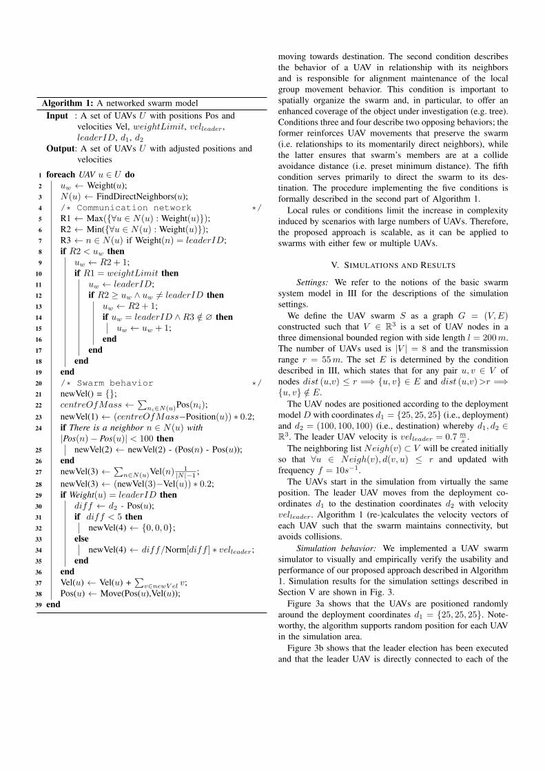
Algorithm 1: A networked swarm modelInput : A set of UAVs U with positions Pos and
velocities Vel, weightLimit, velleader,leaderID, d1, d2
Output: A set of UAVs U with adjusted positions andvelocities
1 foreach UAV u ∈ U do2 uw ← Weight(u);3 N(u) ← FindDirectNeighbors(u);4 /* Communication network */5 R1 ← Max({∀u ∈ N(u) : Weight(u)});6 R2 ← Min({∀u ∈ N(u) : Weight(u)});7 R3 ← n ∈ N(u) if Weight(n) = leaderID;8 if R2 < uw then9 uw ← R2 + 1;
10 if R1 = weightLimit then11 uw ← leaderID;12 if R2 ≥ uw ∧ uw 6= leaderID then13 uw ← R2 + 1;14 if uw = leaderID ∧R3 /∈ ∅ then15 uw ← uw + 1;16 end17 end18 end19 end20 /* Swarm behavior */21 newVel() = {};22 centreOfMass ←
∑ni∈N(u)Pos(ni);
23 newVel(1) ← (centreOfMass−Position(u)) ∗ 0.2;24 if There is a neighbor n ∈ N(u) with
|Pos(n)− Pos(u)| < 100 then25 newVel(2) ← newVel(2) - (Pos(n) - Pos(u));26 end27 newVel(3) ←
∑n∈N(u)Vel(n) 1
|N |−1 ;28 newVel(3) ← (newVel(3)−Vel(u)) ∗ 0.2;29 if Weight(u) = leaderID then30 diff ← d2 - Pos(u);31 if diff < 5 then32 newVel(4) ← {0, 0, 0};33 else34 newVel(4) ← diff/Norm[diff ] ∗ velleader;35 end36 end37 Vel(u) ← Vel(u) +
∑v∈newV el v;
38 Pos(u) ← Move(Pos(u),Vel(u));39 end
moving towards destination. The second condition describesthe behavior of a UAV in relationship with its neighborsand is responsible for alignment maintenance of the localgroup movement behavior. This condition is important tospatially organize the swarm and, in particular, to offer anenhanced coverage of the object under investigation (e.g. tree).Conditions three and four describe two opposing behaviors; theformer reinforces UAV movements that preserve the swarm(i.e. relationships to its momentarily direct neighbors), whilethe latter ensures that swarm’s members are at a collideavoidance distance (i.e. preset minimum distance). The fifthcondition serves primarily to direct the swarm to its des-tination. The procedure implementing the five conditions isformally described in the second part of Algorithm 1.
Local rules or conditions limit the increase in complexityinduced by scenarios with large numbers of UAVs. Therefore,the proposed approach is scalable, as it can be applied toswarms with either few or multiple UAVs.
V. SIMULATIONS AND RESULTS
Settings: We refer to the notions of the basic swarmsystem model in III for the descriptions of the simulationsettings.
We define the UAV swarm S as a graph G = (V,E)constructed such that V ∈ R3 is a set of UAV nodes in athree dimensional bounded region with side length l = 200m.The number of UAVs used is |V | = 8 and the transmissionrange r = 55m. The set E is determined by the conditiondescribed in III, which states that for any pair u, v ∈ V ofnodes dist (u,v) ≤ r =⇒ {u, v} ∈ E and dist (u,v)>r =⇒{u, v} /∈ E.
The UAV nodes are positioned according to the deploymentmodel D with coordinates d1 = {25, 25, 25} (i.e., deployment)and d2 = (100, 100, 100) (i.e., destination) whereby d1, d2 ∈R3. The leader UAV velocity is velleader = 0.7 m
s .The neighboring list Neigh(v) ⊂ V will be created initially
so that ∀u ∈ Neigh(v), d(v, u) ≤ r and updated withfrequency f = 10s−1.
The UAVs start in the simulation from virtually the sameposition. The leader UAV moves from the deployment co-ordinates d1 to the destination coordinates d2 with velocityvelleader. Algorithm 1 (re-)calculates the velocity vectors ofeach UAV such that the swarm maintains connectivity, butavoids collisions.
Simulation behavior: We implemented a UAV swarmsimulator to visually and empirically verify the usability andperformance of our proposed approach described in Algorithm1. Simulation results for the simulation settings described inSection V are shown in Fig. 3.
Figure 3a shows that the UAVs are positioned randomlyaround the deployment coordinates d1 = {25, 25, 25}. Note-worthy, the algorithm supports random position for each UAVin the simulation area.
Figure 3b shows that the leader election has been executedand that the leader UAV is directly connected to each of the

(a) Initial deployment and leader election (b) Establishing communication network and navigation
(c) Navigation and maintenance of communication (d) Positioning of the UAV swarm
Figure 3. Simulation of a networked UAV swarm with self-organizing communication network as described in Algorithm 1. The leader UAV is dark coloredand the established communication network is shown in bold continuous lines.
UAVs in the swarm. Additionally, the leader UAV starts mov-ing towards the destination coordinates d2 = {100, 100, 100}.
Figure 3c shows that the leader UAV pushes the swarmtowards the destination d2. Observe that only the leader knowsthe destination coordinates and the rest of the swarm followsthe leader, while maintaining the swarm behavior.
For initiation of the coverage procedure, we assume that theswarm’s movement to the destination has been realized witha lower transmission range, which keeps the UAVs closer andthe swarm compact. Arriving at the destination coordinates d2the UAVs transmission is extended to its full range. Figure 3dshows the leader UAV arriving at the tree, which represents thedestination. Subsequently, the UAV swarm forms a coveragearound the tree, while maintaining full connectivity to theentire swarm. Each UAV is connected directly or over severalhops to the leader UAV.
Time assessment: Although, the leader UAV pushes theUAV swarm towards the destination d2, the swarm movementprocedure in Algorithm 1 induces a delay in the collective’smovement to avoid disconnection but at the same time toavoid collision between UAVs. Therefore, we are interestedin the movement delay caused by our approach compared toa straight flight of solely the leader UAV from d1 to d2.
For this, we conducted five runs of the simulation, eachwith a different number of UAVs (n = 4, n = 8, n = 12). Wemeasured the time needed for the swarm to arrive at the tree(d2) and compared this to the theoretical time, which is thetime needed by only one UAV to fly directly with velocityvelleader from d1 to d2. This quantitative measure reflectsapplicability and scalability of the proposed approach, sincethe swarm conditions impose influence on the overall task.
Results in Table I and Fig. 4 show that the flying timefrom d1 to d2 (i.e. simulation time in discrete steps) does

Parameter ValueEuclidean distance to destination 129.9
Velocity vector of the leader UAV 0.7Theoretical time to destination 185.57
Run n = 4 n = 8 n = 12
1 190 190 2632 195 199 2833 192 199 2254 196 194 2345 193 201 218
Average 193.2 196.6 244.6
Table ITEMPORAL PERFORMANCE OF THE UAV SWARM.
not differ significantly when 4 or 8 UAVs are deployed (i.e.,1.8% from direct flight time), which is 4.1% time increase forn = 4 and 5.9% for n = 8. However, for the case n = 12,we observe a considerable increase in time (i.e., 31%). Forthe envisioned scenario (i.e., the forest environment where wefocus on assessing one or several trees) the number of UAVsbelow 10 is realistic and practical.
Run
1 2 3 4 5
Tim
e
0
50
100
150
200
250
300
4 UAVs
8 UAVs
12 UAVs
Figure 4. Presentation of the UAV swarm’s temporal performance.
VI. CONCLUSIONS
We propose an approach for the formation flight problem forUAV swarms, which maintain connectivity and communicabil-ity. The two characteristics are important for detailed, precise,and accurate data collection and aggregation, and play a crucialrole in assessing the forest environment. Our approach is basedon local decision-making, and, therefore, assures low messageand computation complexity, while providing scalability fora large number of UAVs in the swarm. Results indicate thatthe proposed swarm movement is almost as fast to reach thedestination location as the theoretical approach comprising ofjust one UAV.
However, melding the aspects of swarm movement andcommunication network is more than a matter of concatenatingtwo isolated aspects. Additional issues of optimal swarmpositioning, such as ad hoc data fusion and object assessment
(e.g. localization and mapping) will be addressed in futurework.
REFERENCES
[1] F. Kendoul, “Survey of advances in guidance, navigation, and control ofunmanned rotorcraft systems,” Journal of Field Robotics, vol. 29, no. 2,pp. 315–378, 2012.
[2] A. Bürkle, F. Segor, and M. Kollmann, “Towards autonomous microuav swarms,” Journal of intelligent & robotic systems, vol. 61, no. 1-4,pp. 339–353, 2011.
[3] G. Danoy, M. R. Brust, and P. Bouvry, “Connectivity stability inautonomous multi-level uav swarms for wide area monitoring,” inACM Symposium on Development and Analysis of Intelligent VehicularNetworks and Applications (ACM DIVANet), pp. 1–8, ACM, 2015.
[4] B. Campbell James and H. Wynne Randolph, “Introduction to remotesensing,” 2011.
[5] R. Shrestha and R. H. Wynne, “Estimating biophysical parameters ofindividual trees in an urban environment using small footprint discrete-return imaging lidar,” Remote Sensing, vol. 4, no. 2, pp. 484–508, 2012.
[6] B. Strimbu and J. Innes, “An analytical platform for cumulative im-pact assessment based on multiple futures,” Journal of environmentalmanagement, vol. 92, no. 7, pp. 1740–1752, 2011.
[7] M. R. Brust, D. Turgut, C. H. Ribeiro, and M. Kaiser, “Is the clusteringcoefficient a measure for fault tolerance in wireless sensor networks?,”in IEEE International Conference on Communications (ICC), pp. 183–187, IEEE, 2012.
[8] M. R. Brust, M. I. Akbas, and D. Turgut, “Multi-hop localizationsystem for environmental monitoring in wireless sensor and actornetworks,” Wiley Journal on Concurrency and Computation: Practiceand Experience, vol. 25, no. 5, pp. 701–717, 2011.
[9] M. R. Brust, C. H. C. Ribeiro, J. A. B. Filho, J. Mesit, and R. K.Guha, “Effective Coverage Area and Network Density in Simulationsof Ad hoc and Sensor Networks,” International Journal of Simulation -Systems, Science and Technology, vol. 10, no. 4, 2009.
[10] J. Schleich, A. Panchapakesan, G. Danoy, and P. Bouvry, “Uav fleetarea coverage with network connectivity constraint,” in Proceedings ofthe 11th ACM international symposium on Mobility management andwireless access, pp. 131–138, ACM, 2013.
[11] C.-F. Huang and Y.-C. Tseng, “The coverage problem in a wirelesssensor network,” Mobile Networks and Applications, vol. 10, no. 4,pp. 519–528, 2005.
[12] T. C. Hales, “The sphere packing problem,” Journal of Computationaland Applied Mathematics, vol. 44, no. 1, pp. 41–76, 1992.
[13] O. R. Musin, “The kissing problem in three dimensions,” Discrete &Computational Geometry, vol. 35, no. 3, pp. 375–384, 2006.
[14] V. Ravelomanana, “Extremal properties of three-dimensional sensornetworks with applications,” Mobile Computing, IEEE Transactions on,vol. 3, no. 3, pp. 246–257, 2004.
[15] M. C. Hansen, D. P. Roy, E. Lindquist, B. Adusei, C. O. Justice,and A. Altstatt, “A method for integrating modis and landsat data forsystematic monitoring of forest cover and change in the congo basin,”Remote Sensing of Environment, vol. 112, no. 5, pp. 2495–2513, 2008.
[16] C. Frey, D. Zarzhitsky, W. M. Spears, D. F. Spears, C. Karlsson,B. Ramos, J. C. Hamann, and E. A. Widder, “A physicomimetics controlframework for swarms of autonomous surface vehicles,” in OCEANS2008, pp. 1–6, IEEE, 2008.
[17] J. L. Sanchez-Lopez, J. Pestana, P. de la Puente, R. Suarez-Fernandez,and P. Campoy, “A system for the design and development of vision-based multi-robot quadrotor swarms,” in Unmanned Aircraft Systems(ICUAS), 2014 International Conference on, pp. 640–648, IEEE, 2014.
[18] Y. Wei, M. B. Blake, and G. R. Madey, “An operation-time simulationframework for uav swarm configuration and mission planning,” ProcediaComputer Science, vol. 18, pp. 1949–1958, 2013.
[19] S. Hauert, J.-C. Zufferey, and D. Floreano, “Evolved swarming withoutpositioning information: an application in aerial communication relay,”Autonomous Robots, vol. 26, no. 1, pp. 21–32, 2009.
[20] D. W. Casbeer, D. B. Kingston, R. W. Beard, and T. W. McLain,“Cooperative forest fire surveillance using a team of small unmannedair vehicles,” International Journal of Systems Science, vol. 37, no. 6,pp. 351–360, 2006.
[21] C. W. Reynolds, “Flocks, herds and schools: A distributed behavioralmodel,” ACM SIGGRAPH Computer Graphics, vol. 21, no. 4, pp. 25–34,1987.