a new deep exploration program and preliminary results of
TRANSCRIPT

Proceedings World Geothermal Congress 2005 Antalya, Turkey, 24-29 April 2005
1
A New Deep Exploration Program and Preliminary Results of a 3D Seismic Survey in the Larderello-Travale Geothermal Field (Italy)
Guido Cappetti(1), Adolfo Fiordelisi(1), Michele Casini(1), Simonetta Ciuffi(1), Alfredo Mazzotti(2) (1) Enel GEM Geothermal Production, Via A. Pisano 120, 56122 Pisa, Italy
(2) Earth Sciences Department-Geophysics, University of Milan, via Cicognara 7, 20129 Milan (Italy) [email protected]
Keywords: Deep exploration, 3D Seismic, Modeling, Larderello-Travale Geothermal System
ABSTRACT
A deep exploration program at the margins and inside of mining licenses in the Larderello-Travale geothermal system has been scheduled in order to increase the steam production for supplying existing power plants with additional fluid and, in case of particular success, to supply new power plants.
Six areas, where previous deep drillings have already ascertained a temperature of about 300°C at a depth of 3000 m, have been selected for this program.
Since a statistically meaningful correlation between deep seismic signatures and fractured/productive horizons has been verified in many wells of the Larderello-Travale geothermal system, 3D seismic reflection surveys have been scheduled in order to improve a detailed individuation of these horizons and, as a consequence, to reduce the drilling mining risk.
A first survey has been carried out in the Gabbro-Sesta area (NE of the Larderello-Travale geothermal system) using dynamite as energy source and a bin size of 25 x 40 m. In spite of the rough morphology of the area, the theoretical full fold of 1600% requested at the depth of the geothermal targets (4500 m b.s.l.) has been guaranteed as average value of the interesting surveyed area.
The survey has been performed on a surface of about 60 km2 with more than 1400 shot holes drilled with at depth of about 12 m and with more than 800000 stations (12 geophones per stations) deployed. A good seismic signal resolution has been guaranteed by a maximum dynamite charge of 3 kg per hole.
The 2D stack lines processed at the end of the acquisition phase show good quality signals and very interesting reflective markers related either to the H and K horizons which are well known seismic evidences of the Larderello-Travale geothermal system. The quality of the acquired data should guarantee good results of the 3D processing phase which is still in progress.
1. INTRODUCTION
The exploration of the oldest Italian geothermal system of Larderello-Travale started at the beginning of the last century.
An intensive exploitation has initially interested the shallow reservoir (Figures 1 and 2) that is hosted in sedimentary formations (limestone and anhydrite), at depth less than 1000 m, and has temperature of about 250 °C.
Since years ‘80 the exploration has been targeted to depths of 3000-4000 m b.s.l. where the first drillings discovered a deep superheated steam reservoir that is characterized by temperatures of 300-350 °C, e.g. Barelli et al. (1995), pressure of up to 70 bar, and is hosted in complex geological systems such as metamorphic and intrusive rocks.
Deep drillings performed up to now also revealed that the deep Larderello-Travale geothermal system is wide more than 400 km2 (see Figures 1 and 2) and includes the shallow fields, e.g. Barelli et al. (2000). Therefore, deep and shallow reservoirs belong to the same geothermal system.
The boundaries of this deep system are not jet known, nor in depth neither in lateral extension. Hence, further exploration and development opportunities are still foreseeable inside and at the margins of mining licenses already under exploitation. A new deep exploration program has been thus scheduled and the availability of green certificates makes this program economically feasible.
2. THE NEW DEEP EXPLORATION PROGRAM
Based on the acquired knowledge and experience, six areas have been selected for the realization of this new deep exploration program that foresees:
3D seismic reflection surveys to be performed in three zones (Figure 3) which group five of the selected areas
the drilling of 11 deep wells up to a depth of 3500-4000 m.
All these areas are internal to the wide Larderello-Travale deep geothermal system which is delimited by temperatures of 250-300°C at a depth of 3000 m.
Previous studies performed in the Larderello-Travale area demonstrated that reflection seismic represents the best tool for the location of deep fractured levels which are the productive targets to reach by drillings.
This motivated the launch of an extensive 3D seismic project, in order to provide reliable targets prior drilling and to reduce the mining risk for 10 of the 11 foreseen wells. An old 3D survey already curried out is enough to define the target for the 11th well.
The program started at the middle of the year 2003 with a 3D seismic survey in one of the three zones and will be ended in the next three years. In particular the seismic surveys, processing and interpretation included, will be ended at the beginning of the 2005 while the wells will be drilled in the end of the 2007.

Cappetti et al.
2
The aim of this program is to verify the presence and extension of deep productive horizons already known in neighbouring areas and indicated as potential targets by seismic signatures.
The success of this program will allow not only the increasing of steam availability for the geothermal power plants already in operation, but also the opening of new prospects for the exploitation of deep geothermal systems. In this way a consistent contribute will be given to the energy production from renewable resources.
3. PREVIOUS SEISMIC EXPERIENCE
Seismic evidences of deep geothermal reservoirs have been already pointed out in the Larderello-Travale area.
A fractured horizon is usually characterized by a decrease both of velocity and density. The magnitude of this decrease depends on many variables (thickness of the horizon, kind of material filling the fractures etc.) and can cause sharp changes of acoustic impedance and, as a consequence, seismic reflections.
Previous studies verified a statistically high correspondence between fractured systems and strong seismic reflectors in the metamorphic basement, e.g. Cameli et al. 2000. In particular, taking in consideration all the fractured levels drilled by geothermal wells at a maximum distance of 200 meters from 2D seismic lines, such correlation was ascertained in more than the 80% of the cases.
The presence of a steam phase filling the fractures may cause a decrease in the VP/VS ratio. In this case, according to AVO theory, increasing the angle of incidence the reflection coefficient modulus increases as well as the “Intercept by Gradient”. Post-stack and pre-stack attribute analysis performed on two intersecting seismic lines effectively pointed out a strong seismic anomalous zone with high reflection amplitude and positive AVO gradient e.g. Mazzotti et al. 2002.
This was confirmed as fractured and steam productive levels by a well drilled near the seismic line intersection (Figure 4) even if its trajectory turned away from the lines of about 400 m.
4. FIRST RESULTS OF A 3D SEISMIC SURVEY
In agreement with the drilling program priorities, the first 3D seismic survey has been curried out in the northern part of the Larderello-Travale geothermal system (see Figure 2) with the technical purpose to guarantee a theoretic full fold ≥ 1600% for an area of about 34 km2 at 4500 m b.s.l, which is the maximum interesting depth of the geothermal targets.
4.1 Acquisition
The acquisition parameters selected for the first 3D survey represents, as usual, a compromise between costs and needs. Major importance was given to the selection of the energy source, of the bin size and of the theoretic maximum fold.
Following the results of analyses on previous 2D seismic data available in the same area, the use of explosive was preferred to vibroseis as energy source. Shot holes with a depth of 10-12 m were drilled and an average of 3 kg of dynamite was fired in each hole. Due to the irregular morphology in the southern sector of the area and to the poor accessibility, many shot holes were drilled by means of a helicopter portable drilling unit.
A bin size of 25×40 m was finally chosen and, in order to assure the requested full fold, the following surface acquisition lay-out was planned:
Source line spaced 500 m each other with shot holes every 80 m (for a total of about 1550 holes);
Receiver lines spaced 480 m each other with geophone groups every 50 m (12 geophones per group in linear spreading).
The final receiver layout matched the planned one while, due to many local problems (i.e. accessibility, private authorization, environmental constrains etc), the acquisition ended with the recording of 1439 shots, instead of the planned 1548. This caused a severe drop of coverage, especially for the short offset, in the SE sector of the survey and at the NW edge, where only few shots could be fired.
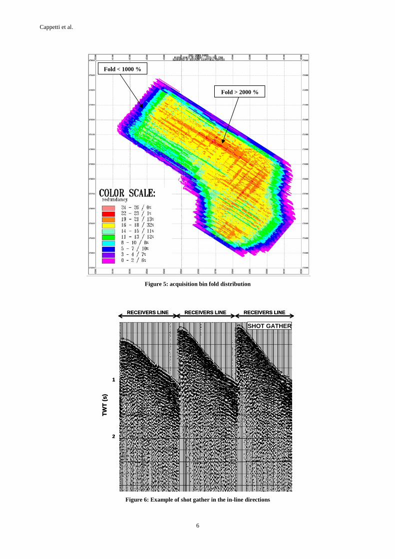
Although the fold was guaranteed at an average value of 1600%, its distribution was not homogeneous and, being conditioned by the acquisition lay out (Figure 5), problems of acquisition footprint can affect the processing and interpretation phase.
More than 7.9E105 traces were recorded. In general the data quality was good, as observed in the raw shot gathers where deep reflection signals are already present (Figure 6), except in zones with high cultural noise.
A preliminary 2D field processing performed in correspondence of the Receiver lines verified the good quality of the acquired data.The processed stack sections (Figure 7) confirmed the presence of two strong and deep reflectors. The deepest one is the already known K horizon, e.g. Batini and Nicholich 1984, Cameli et al. 1993, while the upper one is called H horizon and, on the basis of previous deep wells, can represent an interesting geothermal target.
4.2 Processing
A standard, quick-look 3D processing has been carried out. Due to the strong variations in the surface elevations (from 300 to 1000 m a.s.l.) and to the rapid lateral variations in the surface velocities, the main efforts were focused to the accurate computation of statics. This task was carried out by means of refraction computation and by two passes of residual statics.
Velocity analyses were performed before and after residual static corrections by means of Constant Velocity Stacks and Semblance measurements.
No particular treatment of the signal amplitudes was carried out. The main aim was to (partially) restore the amplitudes by means of simple geometrical spreading corrections and to avoid any operation which might cause artifacts. Also, due to the presence of residual noise in the data, surface consistent operations were not much effective and thus simple trace balancing was applied.
A time variant deconvolution was applied using an operator length of 200 ms and two different prediction distances, 16 and 32 ms respectively.
The final stack products have undergone a zero phase deconvolution and a time variant filtering. The overall quality of the stack images is rather good especially at the targets twt.
The final processing step has been the 3D time migration. Migration operations have always been difficult in this area

Cappetti et al.
3
because of the high velocities, their sudden lateral variations and the presence of noise. All these conditions have been confirmed also in the 3D acquired dataset. In this case, the unhomogeneity of the coverage distribution and, as a consequence, of the S/N ratio of the stacked traces added further problems. For this reason, migration velocities were derived from heavily smoothed and strongly reduced stacking velocities, and migration apertures were limited (Figure 8).
However, the final results allow to solve some interpretation problems related to lateral events that have negatively affected the standard 2D lines.
4.3 Preliminary interpretation results
Since the H horizon is a potential geothermal target, a preliminary interpretation has been focused to the geometric 3D reconstruction of this seismic marker and to a first characterization of its signal amplitude. This with the aim to provide a more reliable target for a deep well to be drilled in the near future.
In particular, the top and the bottom of this horizon have been picked on in-lines and cross–lines of the 3D real amplitude stack volume. For both of these levels a 3D surface has been computed and visualized.
On the 3D volume included in these two levels the RMS amplitude has been computed and mapped on the top surface of the H horizon. Interesting areas characterized by high amplitude values have been identified in the neighbourhood of the well (Figure 9) and indicated as potential targets for the drilling.
Particular care must be taken in the final interpretation due to the presence of acquisition footprints that can mask the real amplitude relations.
5. CONCLUSION
In the framework of the new deep exploration program here described, the aim of the first 3D seismic survey has been providing a clear seismic image of the deep geological structures and of the potential geothermal reservoirs.
In fact, previous 2D seismic lines were significantly affected by lateral events. Also, the 3D seismic survey will allow us to extensively and systematically check the validity of the cause-effect relation between steam saturation in fractured levels and the occurrence of anomalous seismic reflections.
Furthermore this first 3D seismic survey has been also aimed to verify the reliability of the technical acquisition parameters here adopted and their utilization for the surveys to be performed. In particular, the fold value of 1600% can be considered a good compromise between costs and data quality, as well as the utilization of an asymmetric bin of 25x40 m. For the future surveys just the bin orientation will
be changed with the short side in the structural dip direction.
Notwithstanding the difficulties in the data acquisition and processing, the seismic data have been of a fair to good quality, with few problems of acquisition footprints which are being taken care of. The stack and migrated seismic volumes are now being interpreted. Based on production results of existing wells on the same area it is possible confirm the correspondence between anomalous reflection and steam production. Thus, this association may give a key, even if not the unique, for the exploration in this area.
Although more sophisticated processing sequences may produce sharper seismic images and may further reduce ambiguities in the interpretation, the preliminary results look promising as several potential prospects can be highlighted with some confidence. Works are ongoing to calibrate the actual 3D volume to well log data and to extend 3D seismic prospecting to nearby areas.
REFERENCES
Barelli, A., Cappetti, G. and Stefani, G.: Results of deep drilling in the Larderello-Travale/Radicondoli geothermal area. Proceedings World Geothermal Congress, Vol. 2, pp. 1275-1278, Florence, Italy (1995)
Barelli, A., Bertini , G., Buonasorte, G., Cappetti, G. and Fiordelisi, A.: Recent deep exploration results at the margins of the Larderello-Travale geothermal system. Proceedings World Geothermal Congress, n. B6-2, (2000).
Batini, F. and Nicholich, R.: The application of seismic reflection methods to geothermal exploration. U.N. Seminar on Utilization of geothermal energy for electric power production and space heating. Florence, Italy (1984).
Cameli, G.M., Dini, I. and Liotta, D.: Upper crustal structure of the Larderello geothermal field as a feature of post-collisional extensional tectonics (Southern Tuscany, Italy). Tectonophysics, vol. 112, pp. 507-512 (1993)
Cameli, G.M., Ceccarelli, A., Dini, I. and Mazzotti, A.: Contribution of seismic reflection method to the location of deep fractured levels in the geothermal fields of Southern Tuscany (Italy). Proceedings World Geothermal Congress, n. B6-3, (2000).
Mazzotti, A., Zamboni, E., Stucchi, E., and Ciuffi, S.: Seismic characterization of Geothermal Reservoir: a case study in Western Tuscany, Italy. 64th EAGE Conference and Exhibition, Extended Abstract, Vol. I, n.C-37 (2002).

Cappetti et al.
4
Figure 1: Temperature features of the shallow and deep Geothermal Systems of Larderello-Travale. 1)outcrop of permeable formations 2)shallow well 3)deep and recent well 4)temperature at the top of the shallow reservoir 5)temperature at 3000 m b.s.l.
6)cross section trace (see Fig 2.)
Figure 2: Geological cross section (see trace in Fig.1) through the Larderello - Travale Geothermal Systems . 1)Cover formations 2)shallow carbonate-anhydritic reservoir 3)deep metamorphic reservoir 4)temperature contour-line

Cappetti et al.
5
Figure 3: Areas selected for the deep exploration program and 3D seismic surveys . 1)temperature at 3000 m b.s.l. 2)boundaries of 3D seismic survey 3)previous 3D seismic survey 4)planned deep exploration well
Figure 4: 2D Seismic Stack section showing high amplitude reflection to correlate to geothermal targets.
Line 36
Line 16Well
Base of the Ligurid Units
Top of the Metamorphic
Basament
LINE 36
Geothermaltarget
Line 36
Line 16Well
Base of the Ligurid Units
Top of the Metamorphic
Basament
LINE 36
Geothermaltarget
Cappetti et al.
6
Figure 5: acquisition bin fold distribution
Figure 6: Example of shot gather in the in-line directions
RECEIVERS LINE RECEIVERS LINE RECEIVERS LINE
SHOT GATHER
1
2
TW
T (
s)
RECEIVERS LINE RECEIVERS LINE RECEIVERS LINE
SHOT GATHER
1
2
TW
T (
s)
Fold > 2000 %
Fold < 1000 %

Cappetti et al.
7
Figure 7: 2D Stack section obtained along one of the receiver line. The two main seismic horizons (K and H) are evident.
Figure 8: Migrated 3d seismic volume
H horizon
K horizon

Cappetti et al.
8
Figure 9: High RMS amplitude values at the top of the H horizon are circled and can be interpreted as the most promising potential targets for deep drillings
Well