a phase i cultural resources investigation of tract …
TRANSCRIPT

A PHASE I CULTURAL RESOURCES INVESTIGATION
OF TRACT 36590 (THE VISTA SANTA ROSA COMMUNITY), APROXIMATELY 80 ACRES
IN UNINCORPORATED RIVERSIDE COUNTY, CALIFORNIA
Prepared for:
QUILL ENTERPRISES Attn: Paul D. Quill
51245 Avenida Rubio La Quinta, California 92201
Prepared by:
McKENNA et al. 6008 Friends Avenue
Whittier, California 90601-3724 (562) 696-3852
Author and Principal Investigator: Jeanette A. McKenna, MA/RPA
Job No. 08-14-04-1636 April 3, 2014

i
TABLE OF CONTENTS
Page
LIST OF FIGURES .................................................................................................... iii
LIST OF TABLES ...................................................................................................... iv
INTRODUCTION ...................................................................................................... 1
LOCATION AND ENVIRONMENTAL SETTING ...................................................... 1
CULTURE HISTORY BACKGROUND ..................................................................... 7
METHODOLOGY ..................................................................................................... 11
CRITERIA FOR EVALUATION ................................................................................ 13
PREVIOUS RESEARCH .......................................................................................... 14
RESULTS OF THE INVESTIGATIONS .................................................................... 20
Native American Consultation ............................................................................... 21
Result of the Paleontological Survey ..................................................................... 22
Historical Archaeological Resources ..................................................................... 24
Prehistoric Archaeological Resources ................................................................... 27
CONCLUSIONS AND RECOMMENDATIONS ........................................................ 34
CERTIFICATION ...................................................................................................... 35
REFERENCES ......................................................................................................... 36
ii
Page
APPENDICES:
A. Professional Qualifications ................................................................................ A-1
B. Archaeological Records Search ........................................................................ B-1
C. Native American Consultation .......................................................................... C-1
D. Paleontological Overview ................................................................................. D-1
E. Photographic Record ......................................................................................... E-1
F. Supplemental Research Data ........................................................................... F-1
G. California DPR-523 Forms ............................................................................... G-1

iii
LIST OF FIGURES
Page
1. General Location of the Project Area .......................................................... 2
2. Specific Location of the Project Area ........................................................... 3
3. Assessor Parcel Map Illustrating Current Project Area ................................ 4
4. Aerial Photograph Illustrating the Current Project Area ................................ 5
5. Photograph of Surface Vegetation within the Project Area in 2012 .............. 25
6. Surface Burn Area with remnants of Recent Vegetation Clearing ................ 25
7. Isolated Shell Button .................................................................................... 25
8. Overview of the Western Boundary of the Project area from Avenue 61 ..... 28
9. Recorded Locations of Sherds within the Project Area ................................ 29
10. Artifact No. 10 in situ .................................................................................... 32
11. Artifact No. 10 Cleaned ................................................................................ 33

iv
LIST OF TABLES
Page
1. Cultural Resource Investigations Completed within One Mile
of the Current Project Area .......................................................................... 15
2. Resources Recorded within One Mile of the Current
Project Area ................................................................................................ 16
3. Fossil Specimens Recovered from Areas near the Current Project Area ... 23

Job No. 13.1636: Tract 36590 (Vista Santa Rosa Community, Riverside Co., CA) Page 1
A PHASE I CULTURAL RESOURCES INVESTIGATION
OF TRACT 36590 (THE VISTA SANTA ROSA COMMUNITY), APROXIMATELY 80 ACRES
IN UNINCORPORATED RIVERSIDE COUNTY, CALIFORNIA
by,
Jeanette A. McKenna, M.A., RPA
McKenna et al., Whittier CA
INTRODUCTION McKenna et al. (Appendix A) initiated the Phase I cultural resources investigations of Tract 36590 in unincorporated Riverside County, California, at the request of Quill En-terprises, LLC, La Quinta, California. The project area is immediately adjacent to the City of La Quinta and, as proposed, the project area will eventually be annexed into the City. For compliance, this study has been completed in accordance with the require-ments of the County of Riverside Planning Department, Riverside, California. The property is currently used for agricultural purposes and the proposed residential devel-opment will require a zone change and General Plan Amendment, thereby triggering SB-18 consultation between the County and local Native American representatives. Overall, this project is being completed compliance with the California Environmental Quality Act (CEQA), as amended, the County of Riverside, and the City of La Quinta, as applicable.
LOCATION AND ENVIRONMENTAL SETTING This project area, referred to as Tract 36590, is located within unincorporated Riverside County and directly east of the City of La Quinta corporate boundary, Riverside County, California (Figure 1). This location is cross-referenced as being within Township 6 South, Range 7 East, and the eastern half of the northwestern quarter of Section 35 (Figure 2). Consisting of approximately 80 acres, this property is listed by the County Assessor as Assessor Parcel No. 764-290-003 (Figure 3) and bounded by Avenue 60 (north) and Avenue 61 (south). The western boundary is east of a previously planned tract east of Monroe Street (development not completed) and the property east of the project area is agricultural land. This property is also cross-referenced as 82325 Ave-nue 60, Thermal, California.

Job No. 13.1636: Tract 36590 (Vista Santa Rosa Community, Riverside Co., CA) Page 2
Figure 1. General Location of the Project Area.

Job No. 13.1636: Tract 36590 (Vista Santa Rosa Community, Riverside Co., CA) Page 3
Figure 2. Specific Location of the Project Area (USGS Valerie Quadrangle, rev. 1972).

Job No. 13.1636: Tract 36590 (Vista Santa Rosa Community, Riverside Co., CA) Page 4
Figure 3. Assessor Parcel Map Illustrating Current Project Area.
Illustrated in Figure 4, the property is essentially vacant, but includes a modern water reservoir in the northwestern corner. Geographically, this location is near the northern boundary of ancient Lake Cahuilla and at an average elevation of 80 feet above mean sea level. The project area is located within sands and mesquite dunes associated with the shoreline(s) of ancient Lake Cahuilla, a freshwater lake inundated numerous times over the past few millennia (Chace 1996:4). Lake Cahuilla, also referred to as Lake Le Conte, Agua Grande, and Blake Sea; see Jertberg 1981:12 and Wilke 1986:3), once covered much of the Salton Basin, a desert basin landform bordering the northern ex-tent of the Colorado Desert, and is the forerunner of the present-day Salton Sea (see Jertberg 1982:10; Norris and Webb 1990:255; Wilke 1984:3). Citing Wilke (1984:3), “... [T]he basin is bounded by the high Peninsular Ranges to the west, the interior of the Colorado Desert to the east ...”. Lake Cahuilla dried up at approximately A.D. 1500, when the course of the Colorado River was altered and cut off the natural flow to the basin (Chace 1996:4). The last stand of Lake Cahuilla is believed to have been between A.D. 1300 and 1500 (Wilke 1986:3), resulting in the waterline scarring on the east-facing elevations of the Santa Rosa Mountains. At least three major periods (stands) can be documented for Lake Cahuilla, all within the last 2000 years (White and Van Horn 1990:2). Macko (1990:3) stated that the earli-est filling of Lake Cahuilla may have been as early as 37,000 years ago. Referred to as

Job No. 13.1636: Tract 36590 (Vista Santa Rosa Community, Riverside Co., CA) Page 5
“lacustral intervals”, these stands represent the periodic flow of the Colorado River into the Coachella Valley, forming Lake Cahuilla. Between these stands, the lake dried and resources associated with the lake and lake shores were not available.
Figure 4. Aerial Photograph Illustrating the Current Project Area.
Job No. 13.1636: Tract 36590 (Vista Santa Rosa Community, Riverside Co., CA) Page 6
Between fillings, evaporation quickly reduced the lake levels, leaving evidence of reced-ing lake shores often a noticeable crust on the central part of the basin floor. Geological data suggest Lake Cahuilla was last filled between A.D. 900 and 1400 (some argue be-tween A.D. 1300 and 1500), possibly to its highest shoreline (Wilke 1978:57). The Sal-ton Sea, as it is currently defined, was formed in 1905-1906 and maintained by inflow of irrigation wastewater (see Rogers 1945; Aschmann 1959; Yohe 1984; and Wilke 1978 and 1984:3). The Santa Rosa Mountains formed by uplift during the Miocene and Pliocene (Dibble 1954; Hamilton 1961; Padon 1984). Streams running out of the Santa Rosa Mountains are considered intermittent streams while the Whitewater River is the primary fresh wa-ter source for the area (Padon 1984:4). The areas associated with Lake Cahuilla are underlain by the Palm Springs Formation, a soft, non-marine formation known to contain petrified wood and sandstone concretions, and sediments within Lake Cahuilla form a nearly horizontal cover over the buried bedrock. The adjacent Santa Rosa Mountains are composed of both granitics and metamorphic rock. Soils infilling the Coachella Val-ley have weathered from the Santa Rosa Mountains. These materials are generally light colored alluvium and sandy loams with gravel inclusions and the resulting alluvial cover can vary from a few meters thick to excesses of 900 meters in some areas (Cha-ce 1996:4). Sand dunes surrounding Lake Cahuilla are associated with the extensive sand dunes characteristic of the nearby Colorado Desert. Geologists have attributed the dunes to accumulations of sands being blown ashore from the beaches of Lake Cahuilla, sands transported from the Colorado River areas, and/or sands trapped by buried faults. The movement of sands throughout the Colorado Desert has rendered this area the largest tract of desert dunes in North America (Norris and Webb 1990:268). Many areas exhibit remnants of freshwater shell associated with the receding lake shores (Love 1990:6). Freshwater shell includes those of snails (Physa, Planorbis, and Paludestrina) and clams (Anodonta dejecta). In addition, Wilke (1976) and Jertberg (1982) have identi-fied freshwater mussel (Anodonta dejecta), humpback sucker (Xyrauchen texanus), Colorado River bonytail chub (Gila elegans), Colorado River squaw fish (Ptychocheilus lucius), striped mullet (Mugil cephalus), and desert pupfish (Cryprinodon macularis cali-forniensis). Sediments within the current project consist of fine grained sands and silts with little to no evidence of surface shell. The project area is also associated with the Sonoran Life Zone (Munz 1974; Munz and Keck 1949 and 1950). The Sonoran Life Zone supports a desert vegetation which is characterized by the presence of creosote bush (Larrea tridentatal), mesquite (Prosopis glandulosa), and desert sage scrub. Other species known for the area include white bursage (Ambrosia dumosa), burrobush (Hymenoclea salsola), allscale (Atriplex poly-carpa), iodine bush (Allenrolfea occidentalis), quail bush (Atriplex lentiflormis), brittle-bush (Encelia farinosa), dyebush (Dalea emoryi), jumping cholla (Opuntia bigelonni), and pencil cholla (Opuntia ramosissima). Dry washes have yielded evidence of cattail (Typha sp.), tule (Scirpus sp.), arrowreed (Pluchea sericea), palo verde (Carcidium floridum), smoketree (Hyptis emoryi), chuparosa (Beloperone californica), catclaw aca-

Job No. 13.1636: Tract 36590 (Vista Santa Rosa Community, Riverside Co., CA) Page 7
cia (Acacia greggii), thornbush (Lycium), indigo bush (Dalea schottii), desert lavender (Hyptis emoryi); barrel cactus (Ferocactus acanthodes), and beavertail cactus (Opuntia basilaris; see Wilke 1978, 1984 and 1985; Ryan 1968; and Padon 1984 and1985). Kel-ler (1985:4) notes the possible presence of Desert Sand Verbena (Abronia villosa), Sweet Scented Heliotrope (Heliotropium convolculaceum), and Desert Sunflower (Ger-ea canescens). Jertberg (1982) noted the presence of screwbean (P. Pubescens), saltbush (Atriples sp.), seep-weed (Suaeda sp.), prickly pear cactus (Opuntia sp.), yuc-ca (Yucca sp.), goosefoot (Chenopodium sp.), bullrush (Scirpus sp.), and reeds (Phragmites sp.), and various grasses. Fauna associated with this area include various species of mice (Perognathus, Peromyscus), kangaroo rat (Dipodomys), woodrat (Neotoma Lepida), desert cottontail (Sylvilagus audubonii), black-tailed jack rabbit (Lepus californicus), ground squirrels (Ammospermophilus, Citellus), gray fox (Urocyon cinereoargenteus), kit fox (Vules ma-crotis), coyote (Canis latrans), bobcat (Lynx rufus), desert bighorn sheep (Ovis cana-densis nelson; see Wilke 1984 and 1986; and Ryan 1968). Avifauna around the Lake Cahuilla area would have been present year-round (Jertberg 1982:18), including such species as white pelican (Pelicanus erythrorhynchas), Faral-lone cormorant (Phalacrocarap auritus), and great blue heron (Ardia herodias). Average precipitation is approximately three inches per year (predominantly in the win-ter months), with lesser amounts falling during summer monsoons from the Gulf of Cali-fornia. Significant water run-off generally occurs two or three times every five years, re-sulting in a clearing of wind-blown sands from channels and the cutting of steep banks. These channels also provide catchments for wind-blown sands. Temperatures vary considerably, depending on the time of year, but the overall area is generally consid-ered arid; generally mild during the winter months but reaching up to 125o in the sum-mer months (Wilke 1984:4).
CULTURE HISTORY BACKGROUND The project area is within the Coachella Valley, known to be associated with numerous Native American villages and/or settlements (rancherias) of the Desert Cahuilla (Bar-rows 1900; Hooper 1920; Kroeber 1925 and 1976; Curtis 1926; Strong 1929; Bean and Saubel 1972; and Bean 1978). The Desert Cahuilla are one of three distinct Cahuilla populations that are specifically associated with the Coachella Valley. Wilke (1978:129) suggests the Cahuilla migrated into the upland areas after the latest recession of Lake Cahuilla, eventually returning to the desert floor once the area was again vegetated. The population returning to the valley evolved into the Desert Cahuilla as we know them today through ethnographic research. Wilke (1986:4) also asserts the occupation of the Coachella Valley is relatively recent, ca. A.D. 1300-1500, when populations exploited the wetlands located along the north-western shores of Lake Cahuilla (at the present-day site of the communities of Indio and

Job No. 13.1636: Tract 36590 (Vista Santa Rosa Community, Riverside Co., CA) Page 8
La Quinta). In the mid-1800's, U.S. Government surveyors documented the presence of at least twenty-two Cahuilla villages between the San Gorgonio Pass and Coachella Valley; most with populations exceeding 100 individuals (Wilke 1978:120; Wilke and Lawton 1975). Wilke’s studies have shown that the local populations exploited almost every available food source in the area (1978). The Desert Cahuilla relied on springs and wells for fresh water sources. Villages were more often established near the natural springs and other, smaller encampments were founded in areas where “walk-in wells” were excavated (Strong 1929:38), hence the reference to nearby “Indian Wells”. White and Van Horn (1990:4) cited Barrows (1900: 26-27), as follows:
“For generations they have been well-diggers. Their very occupation of this desert was dependent on their discovery of this art. The whole valley of the Cabeson [sic] is dotted with wells, most of them marking sites of homes long ago abandoned, the wells themselves being now only wide pits partly filled with sand, but many dug in the old way still remain, sup-porting life and giving refreshment miles and miles away from the rocky walls where the streams of the mountains disappear in the sands. These wells are usually great pits with terraced sides leading down to the narrow hole at the bottom where the water sparkles, built in such a way that a woman with an olla on her head can walk to the very water’s edge and dip her painted vessel full.”
Population estimates for the prehistoric Cahuilla ranged from 3,600 to 10,000 individu-als. These individuals maintained extensive networks for trade including contacts along the Colorado River and the Pacific Coast. Trails, small camp sites, and other limited use areas have been recorded throughout the Valley and attest to the wide-spread use of the Valley by prehistoric man. Additional evidence of long-term occupation has been identified along the various shorelines of prehistoric Lake Cahuilla. Trade routes (e.g. the Cocomaricopa Trail) and encampments in areas providing fresh water have been identified throughout the Valley and some are known to have been used in historic times by various explorers and settlers of the 1700s and 1800s. With the shifting of sand dunes in the Colorado Desert, archaeological resources associated with the Desert Ca-huilla may be found on the desert surface or buried at various depths throughout the ar-ea (McKenna 1997 and 2006). Wilke (1986:9) also emphasized the Cahuilla did not rely heavily on stone tools. To the contrary, the Cahuilla relied on wooden objects (even as projectile points) and ceramic goods. Nets and traps were used in hunting and fishing. Ceramics (Salton Buff and Tizon Brown) dominate the collections found throughout the area, attesting to the wide-scale use of such vessels. Basketry was also used, but few examples have survived. Recent investigations have also suggested that the Cahuilla practiced limited agricultur-al activities (Wilke 1986:9).

Job No. 13.1636: Tract 36590 (Vista Santa Rosa Community, Riverside Co., CA) Page 9
The Cahuilla practiced a relatively complex social organization – based on lineages and clans. Individual clans occupied village sites and exploited individualized territories. Interactions provided exchange in the forms of trade, marriage alliances, and so-cial/ceremonial contact. Basically, marriage occurred between moieties, thereby avoid-ing marriages between blood relatives. Clan associations were more directly related to the exploitation of resources, trade, and social interaction (McKenna 1997; Love and Tang 1998:4). The Cahuilla practiced cremation and generally burned the residential structure of the deceased individual (Wilke 1986:9). A new residence was then built some distance away, attesting to the mobility of the residential sites. Analysis of ethnographic and archaeological data has resulted in the development of various chronologies for the California Desert, but not specifically for the Coachella Val-ley (Wallace 1962; Warren and Orr 1978; Weide and Barker 1975; Hall and Barker 1975; King and Casebrier 1976; and Gallegos et al. 1979). Jertberg (1982:5-7) synthe-sized the data and proposed the following chronology for comparative purposes:
10,000 to 6,000 B.C.: The Lake Mojave/San Dieguito Complex and/or the Western Lithic Co-Tradition): characterized by the presence of projectile points, large knives, scrapers, chopping tools, and scraper planes (Bettinger and Taylor 1974; Campbell and Campbell 1937; Rogers 1939; Davis et al. 1969). Resources are also associ-ated with food processing and hunting. Sites are commonly found in areas of coniferous woodland and pluvial lakes.
6,000 B.C.-A.D. 500: Archaic or Pinto Armagosa periods (Wallace 1962;
Bettinger and Taylor 1974; Weide and Barker 1974): characterized by diagnostic projectile points and leaf shaped blades, choppers, and scraper planes. Some sites exhibit a small assemblage of milling stones. There is also an apparent shift in climate and vegeta-tion, leading to a shift in exploitation with an emphasis on vegetal resources.
A.D. 500 to Historic: (un-named): characterized by the presence of bows
and arrows (as opposed to darts), ceramics, and cre-mations. The presence of milling tools increase, in-cluding mortars and pestles. There is evidence of lim-ited agriculture and the appearance of Shoshonean-speakers displaced local Hokan-speaking populations (Wallace 1962:176). Sites are spatially associated with the presence of the Lake Cahuilla shorelines and the exploitation of resources directly associated with the lake’s varying high and low water lines.

Job No. 13.1636: Tract 36590 (Vista Santa Rosa Community, Riverside Co., CA) Page 10
Contact with the Desert Cahuilla occurred in the early 1800s. The earliest recorded non-Native interaction with the Cahuilla occurred in 1823 with the Jose Romero expedi-tion through the Colorado Desert (Bean and Mason 1962). This expedition noted the agricultural activities of the Cahuilla (corn, beans, and squash). Wilke and Lawton (1975) suggest the presence of agriculture is a trait derived from contact with popu-lations in or from Mexico, and possibly western Arizona. In 1853, Blake (Blake 1856) completed a survey for the Pacific Railroad, resulting in the recordation of village sites and lifeways, etc., of the Desert Cahuilla. Blake also de-scribed the geology of Lake Cahuilla. U.S. Government surveys in the 1850s led to the additional identification of Cahuilla village locations. In 1855, the U.S. Government sub-divided the Valley into Townships and Ranges, followed in 1856 with the identification of Sections. In 1862, the U.S. Government passed the Homestead Act, leading to the es-tablishment of open lands for homesteading throughout the western United States. Non-native population began to enter the area in greater number and, shortly thereafter, in 1863, a smallpox epidemic decimated the Cahuilla population, essentially clearing the Coachella Valley and making the land available to non-natives (Wilke 1986:10). The United States government granted lands to the various railroads as incentives to establish more routes through rural landscapes and encouraged settlements in these areas. In general, these grants included odd-numbered sections with the right-of-ways running along the Section lines (or wherever the terrain permitted development). In 1901, the Southern Pacific Railroad was granted 3360 acres in the Coachella Valley. Section 35, as an odd-numbered section, would have been fallen into this category. Research through the Bureau of Land Management General Land Office records con-firmed Section 35 was part of the Southern Pacific Railroad grant of 1901 (CACAAA 088772). This grant was no longer recognized by 1913. Data on file at the Riverside County Archives identified no recorded owner(s) for the northwestern quarter of Section 35 between 1892 and 1913. In 1913, the recorded owner of the southwestern quarter of the northwestern quarter (40 acres) was George W. Town. In 1914, the remainder of the northwestern quarter section (120 acres) was owned by Daisy D. Farmer (Book 10; Line 44). Farmer is the listed owner between 1914 and 1920, with a $100 improvement for the property (not necessarily in the eastern 80 acres of the quarter section). In 1920, the entire quarter section (160 acres) was purchased by George A. Webster. No improvements are noted during the Webster ownership (1920-1945), although the property values suggest there may have been some minor improvements somewhere within the 160 acre property (and not necessarily in the form of structural improve-ments). Webster sold the 160 acres in 1945 to Joseph and Lily O’Rourke. The O’Rourkes held the property between 1945 and 1954, again with no listed improvements. However, as previously noted, the values listed suggest improvements, as the land was assessed at over $11,000 in 1954, when Webster sold the land to Ed Peters et al. It was not unusu-al for the Assessor to group structural improvements and agricultural improvements.

Job No. 13.1636: Tract 36590 (Vista Santa Rosa Community, Riverside Co., CA) Page 11
Between 1954 and 1958, the property value increased to $14,400, when the eastern half of the northwestern quarter (80 acres) was sold to David L. Armstrong. Armstrong held the property until at least 1965 with a property value of over $15,280. Based on the information presented above, it appears the property now identified as the 80 (+/-) acre project area was not privately owned until after 1914. Improvements were limited to $100 prior to 1920 and these minor improvements were likely associated with the northwestern 40 acres of the Farmer holdings and not associated with the current 80 acre project area. Given the assessed values, any significant improvements within the current project area appear to post-date 1945 and not specifically identified as structural improvements vs. trees/vines (agricultural). Subsequent research suggested the property was planted in row crops (carrots) after 1945 and before 1990, date trees between ca. 1990 and 2006-2007, and, more recently, back to carrots (McGinnis 2006; Quill 2013, personal com-munication). The modern reservoir identified in the northwestern corner of the project area has been associated with the date trees (1990-2006) and not the prior agricultural activities. There is no historic research data or physical evidence to suggest any structures were ever present within the project area.
METHODOLOGY
To adequately address this Phase I cultural resources investigation, McKenna et al. completed the following tasks:
Task 1. Archaeological Records Check: An archaeological records check was completed at the University of California, Riverside, Eastern Infor-mation Center (UCR-EIC; Appendix B; additional data presented under separate cover). In addition to completing the standard records check, McKenna et al. acquired copies of all pertinent cultural resources re-ports, maps, and documents pertaining to the project area and a one mile radius surrounding the project area.
Task 2: Historic Background Research: The project area is located within an
area known to have been occupied or utilized during both the prehis-toric and historic periods. Therefore, McKenna et al. completed histor-ic research by accessing materials on file at the Bureau of Land Man-agement General Land Office records; the County of Riverside Asses-sor’s Office; the County of Riverside Recorder’s Office; the County of Riverside Archives; the University of California, Riverside, Historic Map Library; local library and historical society sources; and the in-house McKenna et al. library.

Job No. 13.1636: Tract 36590 (Vista Santa Rosa Community, Riverside Co., CA) Page 12
Task 3. Native American Consultation: McKenna et al. contacted the Native American Heritage Commission in Sacramento and inquired into the presence/absence of sacred places within the project area and ob-tained a current listing of individuals on file at the Commission request-ing consultation for projects within Riverside County. McKenna et al. mailed letters to persons on the list and requested comments or re-sponses regarding Native American concerns in this area (Appendix C). Responses, if received, have been incorporated into this report. As a project requiring SB-18 consultation, individuals were instructed to complete Government-to-Government consultation, as well.
Task 4: Paleontological Overview: a paleontological overview was prepared by
McKenna et al. for the general area and incorporated into this report (Appendix D). This research was completed in a manner applicable to the current level of research, but is not a stand-alone comprehensive study. A summary of the results is presented later in this report.
Task 5: Archaeological Field Survey: An intensive field survey of the 80 acre
project area was completed on August 5 and 6, 2013, but Jeanette A. McKenna (MA and Principal Investigator of the McKenna et al.), with the assistance of Richard S. Shepard (MA and Principal Investigator for Shepard Consulting Services). Ms. McKenna is registered as a professional archaeologist by the County of Riverside (Reg. No. 161), as is Mr. Shepard (Reg. No. 210), and both meet the Secretary of the Interior Standards as qualified archaeologists and are Registered Pro-fessional Archaeologists (RPA).
The survey was completed by walking parallel transects through-out
the project area at 10 meter intervals. Where conditions required more intensive coverage, transects were adjusted. Existing disked rows were used for control and the field work was supplemented by a com-plete photographic record (Appendix E) and field notes (on file, McKenna et al.). Supplemental data (Appendices B and F) were used to identify areas of higher sensitivity (e.g. previously recorded resource information). All information needed to complete the standard Califor-nia Department of Parks and recreation forms was compiled (Appendix G).
Task 6. Analysis of the Data Compiled: McKenna et al. completed a prelimi-
nary review of previously completed work and incorporated the more recently compiled historic and field data to assess the potential signifi-cance of any resources identified within the project area. This analysis was conducted in a manner consistent with the current CEQA guide-lines and criteria for identifying and evaluating cultural resources in a Phase I study context.

Job No. 13.1636: Tract 36590 (Vista Santa Rosa Community, Riverside Co., CA) Page 13
Task 7. Preparation of a Technical Report: In compliance with CEQA data re-quirements, McKenna et al. prepared this technical report in a format recommended by the Office of Historic Preservation, Sacramento “Ar-chaeological Resource Management Reports” (ARMR), “Recommend-ed Contents and Format” (OHP 1989); the County of Riverside guide-lines and policies; and the UCR-EIC guidelines and policies.
CRITERIA FOR EVALUATION The criteria for evaluating cultural resources for significance under the guidelines of the California Environmental Quality Act, as amended (1999), read: 15064.5. Determining the Significance of Impacts to Archeological and Histori-
cal Resources [new section]
a) For purposes of this section, the term “historical resources” shall in-clude the following:
1) A resource listed in, or determined to be eligible by the State His-
torical Resources Commission, for listing in the California Regis-ter of Historical Resources (Pub. Res. Code §5024.1, Title 14 CCR, Section 4850 et seq.).
2) A resource included in a local register of historical resources, as
defined in section 5020.1(k) of the Public Resources Code or identified as significant in an historical resource survey meeting the requirements section 5024.1(g) of the Public Resources Code, shall be presumed to be historically or culturally significant. Public agencies must treat any such resource as significant un-less the preponderance of evidence demonstrates that it is not historically or culturally significant.
3) Any object, building, structure, site, area, place, record, or manu-
script which a lead agency determines to be historically significant or significant in the architectural, engineering, scientific, econom-ic, agricultural, educational, social, political, military, or cultural annals of California may be considered to be an historical re-source, provided the lead agency’s determination is supported by substantial evidence in light of the whole record. Generally, a re-source shall be considered by the lead agency to be “historically significant” if the resource meets the criteria for listing on the Cali-fornia Register of Historical Resources (Pub. Res. Code§5024.1, Title 14 CCR, Section 4852) including the following:

Job No. 13.1636: Tract 36590 (Vista Santa Rosa Community, Riverside Co., CA) Page 14
A) Is associated with events that have made a significant contri-bution to the broad patterns of California's history and cultural heritage;
B) Is associated with the lives of persons important in our past; C) Embodies the distinctive characteristics of a type, period, re-
gion, or method of construction, or represents the work of an important creative individual, or possesses high artistic values; or
D) Has yielded, or may be likely to yield, information important in
prehistory or history.
b) The fact that a resource is not listed in, or determined to be eligi-ble for listing in the California Register of Historical Resources, not included in a local register of historical resources (pursuant to section 5020.1(k) of the Public Resources Code), or identified in an historical resources survey (meeting the criteria in section 5024.1(g) of the Public Resources Code) does not preclude a lead agency from determining that the resource may be an histor-ical resource as defined in Public Resources Code sections 5020.1(j) or 5024.1.
PREVIOUS RESEARCH Previous research data was compiled through the University of California, Riverside, Eastern Information Center, Riverside, California (see Appendix B). The results of the investigations showed that the project area was previously surveyed once before (Mc- Ginnis 2006) and a minimum of thirteen (13) other studies have been completed within a one mile radius (Table 1). Not included in the records search was the report by Dahdul and Quinn (2008) address-ing the monitoring program for Tentative Tract 30023 (p/o Coral Mountain), due west of the current project area. Also not identified in the records search was the 2010 Phase III study completed by McDougall and Mirro (Applied EarthWorks, Inc., Hemet). As mapped, the 80 acres to either side of the current project area were surveyed (high-lighted in Table 1) between 1991 and 2005 and the 80+/- acres to the west, including the recorded site CA-RIV-5211, were subjected to data recovery in 2010. The report has recently been received by the UCR-EIC, but is not yet in their system and not avail-able for review. The development was never completed, indicating a stop-work order may have been issued (development and archaeological data recovery). Small ex-cerpts from the draft report were made available from a third party (who wishes to re-main anonymous) and the data presented in this report with respect to CA-RIV-5211 data recovery was drawn from this draft report.

Job No. 13.1636: Tract 36590 (Vista Santa Rosa Community, Riverside Co., CA) Page 15
Table 1. Cultural Resources Studies Completed within One Mile
of the Current Project Area.
NADB No. Report No. Citation Description
1083197 RI-00132 Brock 2003 28.73 Acres at Monroe and Avenue 61 1080760 RI-00709 Desautels 1979 O’Neal Property, Coachella Valley 1082400 RI-01936 Parr 1985 Wastewater Treatment Plant 1083766 RI-03203 Everson 1991 Tentative Parcel 26730 1084441 RI-03668 Keller 1993 Tentative Parcel 27430 1085239 RI-04084 Love 1998 Coral Mountain Project 1087019 RI-05656 Demcak and Wade 2005 CA-RIV-5211/H (Tract 31732) 1087771 RI-06408 Hogan et al. 2005 Coral Mountain Project Monitoring 1087821 RI-06456 Hogan et al. 2005 Coral Mountain Expansion-Testing 1087856 RI-06491 Tang et al. 2005 Enclave at La Quinta 1088002 RI-06635 Tang et al. 2006 Tentative Tract 32398 108------- RI-07205 Mirro and Formica 2007 Tentative Tract 35238 108------- RI-07656 McGinnis 2006 Desert Ranch Development 108------- RI-07661 McGinnis 2006 Luna Vista Development
As a result of the studies identified above, a minimum of sixty-five (65) resources were recorded, including those listed in Table 2. As listed, 38 resources can be characterized as isolated finds (35 prehistoric and 3 historic) scattered around the larger sites. Refer-ences to CA-RIV-6115 were added to this discussion, as that data was only recently re-ceived. CA-RIV-6115, a small site mapped as being located near the western boundary of the current project area, but actually within the adjacent property. It is also noted that CA-RIV-16995 (pumice), CA-RIV-16997 mano), and CA-16998 (core) were recorded as sites, while they are actually isolates. Additional resources know for the general area include the site of the Toro Village, three other large habitation sites, one campsite, two isolated hearths, six relatively small ce-ramic/lithic scatters; five moderately sized ceramic/lithic scatters, three sites with evi-dence of cremations, and two historic irrigation features. As mapped, the resources presented in Table 2 are predominantly located west of the mid-section line of Sections 26 and 35 of T6 S, R 7 E, and Section 3 of T 7 S, R 7 E. Most of the resources are identified in Sections 27 and 34 – due west of the current pro-ject area. As identified, the resources form a circular pattern that encompasses the ele-vations below 80 feet above mean sea level. The current project area is between 80 and 90 feet above mean sea level and due east of these identified resources. Surveys completed east and south of the project area yield little to no evidence of resources, despite relatively dense coverage, but suggest-ing occupation in the area was to the west and north of the standing Lake Cahuilla wa-ter line (near 80 feet AMSL).

Job No. 13.1636: Tract 36590 (Vista Santa Rosa Community, Riverside Co., CA) Page 16
Table 2. Resources Recorded within One Mile of the Current Project Area.
Site No. Citation Description Location
CA-RIV-1337
Wilke 1972 Cremation; Sherds, Dike, Burned Structures
Section 3
CA-RIV-273 and 1343
Wilke 1972 and 1980; Love 1998;
Ballester 2003
Cremations; FAR; Sherds, Lithics, etc. Section 34
CA-RIV-1344
Wilke 1972 Campsite with Sherd Scatter Section 3
CA-RIV-5158
Gallegos et al. 1987; Love 1998;
Smallwood 2004; Ballester 2005
Habitation Site with Human Remains Section 26
CA-RIV-5211
Gallegos et al. 1987; Love 1998
Habitation Site Section 35
33-05212 Gallegos et al. 1987; Love 1998;
Ballester 2003
40 Acre Habitation Site Section 27
CA-RIV-6115
Love 1998 Small Lithic and Ceramic Scatter Section 35
33-08331 Coke Wood 1967 Toro Village Section 3 33-08969 Love 1998 Irrigation System Section 34 33-08971 Love 1998 37 Sherds and Lithic Scatter Section 34 33-08973 Love 1998 Five Sherds; One Core; Two Amethyst Section 34 33-08975 Love 1998 135 Scattered Sherds Section 34 33-08976 Love 1998 70 Scattered Sherds Section 34 33-08977 Love 1998 1 Sherd and 5 Amethyst Glass Frags. Section 34 33-08378 Love 1998 Six Sherds and One Amethyst Glass Section 34 33-08379 Love 1998 Five Scattered Sherds Section 34 33-08380 Love 1998 18 Scattered Sherds Section 34 33-08381 Love 1998 Three Sherds Section 35 33-08382 Love 1998 26 Scattered Sherds Section 34 33-08384 Love 1998 110 Scattered Sherds Section 34 33-08385 Love 1998 Three Sherds Section 27 33-08958 Love 1998 Brownware Sherd Section 34 33-08959 Love 1998 Brownware Sherd Section 34 33-08962 Love 1998 Three Brownware Sherds Section 34 33-08965 Love 1998 Amethyst Glass Fragment Section 34 33-08966 Love 1998 Brownware Rim Sherd Section 34 33-08967 Love 1998 Brownware Sherd Section 34 33-08968 Love 1998 Brownware Sherd Section 34 33-08969 Love 1998 Brownware Sherd Section 34 33-08970 Love 1998 Brownware Sherd Section 34 33-08971 Love 1998 Brownware Sherd Section 34 33-08974 Love 1998 Brownware Sherd Section 34 33-08975 Love 1998 Brownware Sherd Section 34 33-08976 Love 1998 Brownware Sherd Section 34 33-08977 Love 1998 Brownware Sherd Section 34

Job No. 13.1636: Tract 36590 (Vista Santa Rosa Community, Riverside Co., CA) Page 17
Table 2. Resources Recorded within One Mile of the Current Project Area (cont’d.).
Site No. Citation Description Location
33-08978 Love 1998 Brownware Sherd Section 34 33-08979 Love 1998 Granitic Bifacial Mano Section 34 33-08980 Love 1998 Brownware Sherd Section 34 33-08981 Love 1998 Brownware Sherd Section 35 33-08982 Love 1998 Brownware Sherd Section 35 33-08983 Love 1998 Brownware Sherd Section 35 33-08984 Love 1998 Amethyst Glass Fragment Section 35 33-08985 Love 1998 Three Brownware Sherds Section 35 33-08986 Love 1998 Brownware Sherd Section 35 33-08987 Love 1998 Brownware Sherd Section 35 33-08989 Love 1998 Brownware Sherd Section 35 33-08990 Love 1998 Brownware Sherd Section 34 33-08991 Love 1998 Brownware Sherd Section 34 33-08992 Love 1998 Brownware Sherd Section 34 33-08999 Love 1998 Brownware Sherd Section 27 33-11570 Ballester 2002 Metate and Mano Fragments Section 34 33-12955 Ballester 2003 Sparse Sherd and Lithic Scatter Section 27 33-12757 Brock 2003 Water Well & Transportation Feature Section 34 33-16995 McGinnis 2006 Chert Flake Section 35 33-16997 McGinnis 2006 Granitic Mano Section 35 33-16998 McGinnis 2006 Metavolcanic Core Section 35 33-17249 Ballester 2002 Fire Hearth Feature Section 34 33-17248 Ballester 2002 Fire Hearth Feature Section 34 33-17247 Ballester 2002 Human Cremation Section 34 33-17754 Porter 2002 Isolated Fragment of Pumice Section 34 33-17756 Porter 2002 Isolated Groundstone Fragments Section 34 33-17758 Porter 2002 Shell Bead Section 34
The reported locations of known cremations are within sites CA-RIV-1337 (to the southwest), CA-RIV-273/1343 (to the southwest), and Site 33-17247 (south/southwest). The village sites are located in Sections 27, 27, and 35. Site CA-RIV-5211 is located directly west of the project area – mapped to the property boundary between the current project area and the property to the west. This site was originally recorded by Gallegos in 1981 and described as a disturbed site located within a plowed field. The artifacts included 28+ ceramic sherds, one mano, and one piece of fire-affected rock. The areal extent of the site was recorded as covering 244 square meters. In 1998, Love completed an updated record reporting the site to cover 440 meters by 315 meters (138,600square meters) and consisting of a 30 acre area yielding 500+ ce-ramic sherds, chipped stone artifacts of various lithic types, several manos, hammer- stones, a pumice abrader, three projectile points, and a centralized a living service. No human remains were identified, but reported as “possible.” This site was tentatively dated to A.D. 1650 and the last recession of the Lake Cahuilla shoreline.
Job No. 13.1636: Tract 36590 (Vista Santa Rosa Community, Riverside Co., CA) Page 18
Summarizing Hogan (2013), Demcak and Wade tested CA-RIV-5211 in 2005 and de-termined the site was a significant resource. They recommended an archaeological monitoring program during proposed development activities. Applied EarthWorks con-ducted the monitoring program between September of 2005 and June of 2006, con-ducted Phase III data recovery, and reportedly completed their extensive draft report in November, 2010 (McDougall et al. 2010). Citing McDougall et al. (2010:8-9):
“In 2005, Archaeological Resource management Corporation (ARMC) was retained by the Project developer … to conduct Phase II test level investi-gation at CA-RIV-5211/H …[and] entailed a resurvey of the site area, and a 100 percent surface collection of all cultural materials on the ground sur-face. Based on the distribution of the surficial artifacts identified, subsur-face investigation consisted of manual excavation of eight Shovel Test Pits (STPs) 50 to 75 Centimeters (cm) in diameter and ranging in depth from 46 to 100 cm below ground surface (bgs), eight 2 by 2 m Shovel Scrape Units (SSs) ranging from 10 to 20 cm in depth, and seven 1 by 1 m Test Units (TUs) excavated to maximum depths of 50-100 cm bgs. The STPs were excavated until a substratum sterile of cultural materials was encountered, while the TUs were excavated until two culturally sterile arbi-trary 10 cm levels were reached in succession, or when the unit reached recognizable lakefloor (i.e. Lake Cahuilla) deposits. All sediments were screened through 3-millimeter (mm) hardware mesh (Demcak and Wade 2005:14-21). “Additionally, five trenches 3 m in length were excavated mechanically us-ing a backhoe with a 24-inch (in.) wide bucket to explore for deeper cul-tural deposits potentially dating to the Late Archaic period. These trench-es were excavated to depths ranging from 150 to 156 cm bgs, and an es-timated 10 percent of the excavated sediment volume from the trenches was screened through 3 mm hardware trench. The total volume of sedi-ments sampled by the various types of manual excavation units and me-chanical trenches amounted to 20.2 m3 (Demcak and Wade 2005:20-21). The Phase II investigations … resulted in the recovery of 150 pieces of lithic debitage, 15 cores, nine flake tools, seven projectile points, five hammerstones, four bifaces, three abraders, one core tool, four metate fragments, two mano fragments, one Olivella biplicata wall disc shell bead, one modified bird bone, one fragment of highly-calcined large mammal bone, and 1,437 ceramic sherds (Demcak and Wade 2005:22-27, 38). Within the STPs excavated, cultural materials were found at depths rang-ing from 15 to 61 cm bgs. The TUs yielded cultural materials from a min-imum of 10 m to a maximum of 60 cm bgs, while cultural materials were recovered to a maximum of 80 cm bgs within the trenches excavated. Additionally, one subsurface cultural feature consisting of a discrete char-coal concentration associated with burned/oxidized sediments was en-countered within the profile of Trench No. 3 at a depth of 50 to 62 cm bgs

Job No. 13.1636: Tract 36590 (Vista Santa Rosa Community, Riverside Co., CA) Page 19
(Demcak and Wade 2005:18-21). According to ARMC, all of these cultur-al remains were encountered within the two highly disturbed (i.e. from ag-ricultural activities), uppermost strata (a root zone and a plow zone) of sandy silty alluvium overlying a clay hardpan of lake floor deposits that was “encountered at roughly 50 cm below datum.” No midden-altered sediments were encountered during testing (Demcak and Wade 2005:43). Upon completion of the testing phase, the artifacts were turned over to the City of La Quinta for curation.”
ARMC concluded the prehistoric deposits associated with CA-RIV-5211/H dated be-tween A.D. 1000 and 1650 (based on diagnostic artifacts) and between A.D. 1260 and 1620, based on carbon dates. Obsidian hydration dates indicated the potential for at least two separate periods of occupation. ARMC made no mention of human remains. Applied EarthWorks, Inc. conducted their monitoring program over the course of almost ten months. This monitoring program included the physical monitoring of all grubbing and surface vegetation removal, removal of agricultural features (i.e. irrigation features), the relocation of existing utilities, and mass grading of the property. McKenna et al. was able to acquire a portion of this report from an outside source (the report was not cited in the UCR-EIC records search). McDougall et al. (2010:xxi-xxii) stated:
“Site CA-RIV-5211/H was previously determined eligible for listing on the California Register of Historical Resources (CRHR) under Criterion 4, be-cause the data potential of the site has made a significant contribution to understanding the broad patterns of California’s history and cultural herit-age (Demcak and Wade 2005:55). The archaeological deposits that were identified during archaeological monitoring of Project construction and emergency data-recovery excavations, which include 18 primary human cremation features; seven secondary human cremation features; three canid cremations/burials; 53 primary burn pits; 11 secondary burn pits; and two miscellaneous features, contribute further to the overall signifi-cance of this resource … “In total, 94 features were identified, and it appears that the majority of the features and artifacts are associated with mortuary ceremonies, such as cremation and the clothes burning ceremony, bu the Late Prehistoric and Protohistoric Cahuilla Indians. Thus, the data indicate that CA-RIV-5211/ H served as a tulwenive or niskicweniva, or place of cremation, possibly for the Cahuilla clans that resided at the village of Mauulmii (Toro), located approximately 0.5 miles (mi) to the southeast of CA-RIV-5211/H. There is little to no evidence that the site was used for habitation purposes. Abso-lute and relative chronological data obtained from CA-RIV-5211/H indi-cates that the sire was used between A.D. 1400 and 1800.”

Job No. 13.1636: Tract 36590 (Vista Santa Rosa Community, Riverside Co., CA) Page 20
Maps developed by Applied EarthWorks were not available for review. However, based on the data obtained from the portions of the Applied EarthWorks, Inc. draft report, McKenna et al. concluded the potential for additional components of CA-RIV-5211/H is relatively high and additional components are likely to be present within the property ad-jacent to the east (the current project area). Such additional components may be identi-fied in a surficial and/or subsurface context. The subsurface deposits may extend up to one meter below the surface and multiple periods of use may be represented. Until additional information on the Applied EarthWorks data recovery program is located or made available, the status of the artifacts and where they are curated remains un-known. During further studies within the current project area, this data will be re-searched and, hopefully, resolved. It is beyond the scope of the current Phase I study to complete this search for the artifact assemblage. The presence of CA-RIV-5158, due north of CA-RIV-5211 and separated only by Ave-nue 60, is also a likely component/extension of CA-RIV-5211/H. Based on the data provided through a review of previous research, the overall project area is considered highly sensitive for the presence of significant prehistoric archaeological resources and considerably less sensitive for the presence of historic archaeological resources. The prehistoric resources are likely to be found in the form of isolated artifacts (mainly ceramic sherds or lithics), but may also manifest themselves in the form of habitation features, specialized use areas, and/or burials (cremations) or burial goods. If present, these features would be considered part of CA-RIV-5211/H and, therefore, also eligible for listing in the California Register of Historical Resources and/or the National Register of Historic Places.
RESULTS OF THE CURRENT INVESTIGATIONS The recent cultural resources investigation of the Vista Santa Rosa Community project area (Tract 36590) in unincorporated Riverside County was initiated by McKenna et al. in August, 2013, and completed in September, 2013. Upon County review of the draft reports (September 2013 and December 2013), this final report was prepared in April, 2014. At the time of the field investigation, the project area was identified as vacant ag-ricultural land that was recently disked and in preparation for row-crop planting (carrots). There were no impediments to completing the field survey other than some recent wa-tering resulting in wet and muddy patched throughout the southeastern portion of the property.
Native American Consultation
On July 30, 2013, McKenna et al. contacted the Native American Heritage Commission to inquire into the presence/absence of sacred or religious Native American resources in or near the current project area. The Commission responded that their files failed to identify any such resources, despite the extensive human remains (cremations) and

Job No. 13.1636: Tract 36590 (Vista Santa Rosa Community, Riverside Co., CA) Page 21
other findings of Applied EarthWorks, Inc. in 2010. The Commission did note that they have resources “… in close proximity …”, but did not identify these resources by num-ber. McKenna et al. assumed this comment was in reference to the nearby location of Toro Village. The Native American Heritage Commission provided a list of local Native American rep-resentatives requesting notification of any projects being conducted within their ances-tral territories. In this case, the Commission identified twelve groups or individuals, in-cluding: Doug Welmas, Cabazon Band of Mission Indians Shane Chapparosa, Los Coyotes Band of Mission Indians Joseph Hamilton, Ramona Band of Cahuilla Mission Indians Mary Resvaloso, Torres-Martinez Desert Cahuilla Indians John Marcus, Santa Rosa Band of Mission Indians Mary Ann Green, Augustine Band of Cahuilla Mission Indians William Madrigal, Morongo Band of Mission Indians Matthew Krystal, Torres-Martinez Desert Cahuilla Indians Judy Stapp, Cabazon Band of Mission Indians Patricia (Tuck) Garcia, Agua Caliente Band of Cahuilla Indians Karen Kupcha, Augustine Band of Cahuilla Mission Indians Luther Salgado, Cahuilla Band of Indians McKenna et al. sent letters to these individuals (Appendix C) on July 30, 2013, and ex-plained the property is in unincorporated Riverside County, but planned for annexation to the City of La Quinta. The property will be rezoned from agricultural land to residen-tial property and the General Plan will be amended to reflect this Zone Change. The McKenna et al. consultation at this level was not intended to comply with SB-18 (Gov-ernment-to-Government consultation) and the Native American representatives were referred to the County for further consultation. As a result of the McKenna et al. consultation, McKenna et al. has received a single formal response from the Agua Caliente Band of Cahuilla Indians stating they had no specific concerns, but referred McKenna et al. to the Torres Martinez. Ms. Garcia, THPO for the Agua Caliente Band of Cahuilla Indians also stated they would be availa-ble for additional consultation should no other entity respond. McKenna et al. assumed any additional consultation would be managed through direct communication between the various Native American representatives and the County and/or the City of La Quinta. Despite the limited communication at the McKenna et al. level, McKenna et al. is well aware of the high level of sensitivity for this area and antici-pates the County’s receipt of comments from one or more of the entities identified above.

Job No. 13.1636: Tract 36590 (Vista Santa Rosa Community, Riverside Co., CA) Page 22
Results of the Paleontological Survey
A formal paleontological survey was not conducted in any manner other than in con-junction with the archaeological field survey. However, the County files identify the pro-ject area as being within an area of designated as having a high sensitivity for paleonto-logical resources (Appendix D). The County files state “… based on geologic for-mations or mappable rock units that are rocks that contain fossilized body elements, and trace fossils such as tracks, nests and eggs. These fossils occur on or below the surface.” A soil survey (“Soil Survey, the Coachella Valley Area, California”), prepared by Kocher and Harper (1928:515), describe this area as consisting of “Indio Loam” and state:
“Usually the Indio Loam has the appearance of very fine dandy loam, but when slightly moistened it becomes cohesive and plastic, showing the ef-fect of a rather high content of silt and clay. The soil is deficient in organic matters, is apparently rich in lime, and all parts of the profile contain vary-ing quantities of other mineral salts.”
A recent paleontological overview completed for a nearby project, Dr. Samuel McLeod of the Natural History Museum of Los Angeles County, identified the area consisting of primarily of younger Quaternary deposits that are unlikely to contain any evidence of significant vertebrate fossils. However, lacustrine and fluvial deposits (lake and stream channel deposits associated with the northern extent of Lake Cahuilla) and dating to the late Pleistocene or Holocene (less than 10,000 years of age) and likely to be present beneath the younger deposits. These lacustrine and fluvial deposits have been known to yield fossil specimens. In fact, fossil specimens have been recovered from similar deposits in the vicinity of Madi-son Street and Avenue 58 – consisting of “… significant fauna … terrestrial and fresh-water vertebrates … as well as diatoms, land plants, clams, snails an crustaceans. A single jaw of the bighorn sheep Ovis Canadensis were recovered … east of Madison Street.” Dr. McLeod concluded shallow excavations are not likely to encounter fossil specimens, but deeper excavations that impact the older Quaternary Lake Cahuilla deposits “ … may well encounter significant paleontological remains.” The specimens are likely to be small and isolated, recovered from soil sampling only. Dr. McLeod recommended pale-ontological monitoring and soil sampling for excavations extending into these older de-posits. Specimens likely to be present are presented in Table 3. In concurrence with the recommendations of Dr. McLeod, McKenna et al. is also rec-ommending any excavations associated with the proposed development that exceed the relative depth of the younger Quaternary dunes be monitored by a qualified paleon-

Job No. 13.1636: Tract 36590 (Vista Santa Rosa Community, Riverside Co., CA) Page 23
tological monitor. This monitoring program should be undertaken in a manner con-sistent with the general protocols of the Western Center, Hemet, Riverside County, and the San Bernardino County Museum Vertebrate Paleontological Section, Redlands, and include the recovery of soil samples to verify the presence/absence of small fossil spec-imens.
Table 3. Fossil Specimens Recovered from Areas near the Current Project Area.
Osteichthyes Catostomidae Xyrauchen texanus Razorback sucker Cyprinidae Gila elegans Bonytail Cyprinodon macularius Desert pupfish Reptilia Squamata Iguanidae Phrynosoma platyrhinos Desert horned lizard Sceloporus magister Desert spiny lizard Uma inornate Coachella Valley fringe-toed lizard Urasaurus graciosus Long tailed brush lizard Aves Passeriformes Advanced land birds Mammalia Lagomorpha Leporidae Sylvilagus Cottontail Rabbit Rodentia Cricetidae Neotoma lepida Desert wood rat Peromyscus White-footed mouse Heteromyidae Dipodomys Kangaroo rat Perognathus longimembris Pocket mouse Sciurdae Ammospermophilus leucurus Antelope ground squirrel

Job No. 13.1636: Tract 36590 (Vista Santa Rosa Community, Riverside Co., CA) Page 24
The monitoring program should be preceded by the preparation, review, and approval of a PRIMP (Paleontological Resources Impact Mitigation Program) detailing the approach to the paleontological mitigation program. All specimens recovered as a result of the program must be curated in a recognized curatorial facility (e.g. the Western Center).
Historic Archaeological Resources
Research into the ownership and land uses within the project area confirmed the prop-erty was not held in private hands until 1914. Land values were relatively low and the first recognized improvements were not indicated until after World War II. Maps and oral histories identified the property as being under row-crop cultivation between ca. 1945 and 1990. Properties surrounding the current project area were also under row-crop cultivation (carrots). With respect to the current project area, the presence of row-crops is visually illustrated on the USGS Valerie Quadrangle (not illustrated as orchard development). In 1990, the agricultural use of the current 80 acre project area shifted away from the row-crops and the property was planted in date palms. This shift altered the pattern of land use from a shallow root and plow zone (less than 1.5 feet) to a deeper root zone (palm tree roots) and the introduction of irrigation associated with the modern reservoir development and the installation of a buried concrete irrigation system. While some date palms may exhibit relatively shallow root zones, the average depth is still more than three feet below surface and, in some instances, quite a bit deeper. In this particular area, the relative depth is likely not to have exceeded the depths of soils above the buried Lake Cahuilla lake bed (identified on the adjacent property between two and three feet below surface). The further west one goes, the shallower Lake Ca-huilla would have been. The date palms were still present on the property in 2006, when the Tierra Environmen-tal Services, Inc. survey was completed. Sometime between 2006 and 2012, these palms were removed and the property became overgrown with weeds and the begin-nings of the regenerating desert vegetation (Figure 5). More recently, in 2013, the property was cleared of the vegetation and preparation for the planting of row-crops was initiated. Evidence of this clearing was present in the form of sporadic areas throughout the property where vegetation was piled and burned (Figure 6). The removal of the date palms would have been completed by chaining or dragging to pull the trees out of the ground and mulched, as witnessed in other areas of the Coachella Valley. Subsequently, the surface area has been disked, turned, and watered. Artifacts or evi-dence of subsurface features (e.g. fire affected rock or grinding stone, would likely have been exposed, as hundreds of artifacts were recovered from the surface of the property to the west (within CA-RIV-5211/H).

Job No. 13.1636: Tract 36590 (Vista Santa Rosa Community, Riverside Co., CA) Page 25
Figure 5. Photograph of Surface Vegetation within the Project Area in 2012 (South/Southeast from Avenue 60).
Figure 6. Surface Burn Area with Remnants of Recent Vegetation Clearing (Irrigation pipe currently placed across this area).

Job No. 13.1636: Tract 36590 (Vista Santa Rosa Community, Riverside Co., CA) Page 26
The recent Phase I archaeological survey of the project area failed to result in the identi-fication of any significant historic archaeological resources. McKenna et al. identified the presence of two small fragments of amethyst glass and one shell button (Figure 7).
Figure 7. Isolated Shell Button. There were no markings on this button and nothing to identify a maker or manufacturer. No other fragments of the button were identified and no clothing associated with the but-ton was found nearby or on the property. This is likely a primary loss of the button (off a shirt without notice) and not a deliberately discarded item. The button was recovered and is currently curated at the McKenna et al. office in Whittier, California. It is not a significant artifact. Amethyst Glass: The two small fragments of amethyst glass were identified on the surface of the proper-ty and without provenience (within disking furrows). The first fragment was found in as-sociation with two pieces of modern glass (green and blue) near the northern boundary of the property. The second fragment was identified south of the modern reservoir. Generally, amethyst glass is associated with the pre-World War I period (pre-1917) and the amethyst coloring develops when the pre-1917 glass is exposed to sunlight for an extended period of time. In this case, it appears the glass may be associated with the sparse historic artifact component identified within CA-RIV-5211/H, to the west, and these few items have been scattered as a result of the earlier agricultural activities and/or disturbances result-ing from the construction of the modern reservoir. The historic component of CA-RIV-5211 was not considered significant during earlier studies. These isolated and relatively
Shell Button: This fragment of a shell button was recovered from the surface of the project area as an isolat-ed artifact. Identified at UTM co-ordinates 571642 Easting and 3718563 Northing, this button was found just north of Avenue 61 and near the southwestern corner of the project area. This button is a two-hole button measuring ½ inch in diameter. It is currently very thin, as much of the shell material has sepa-rated from the artifact.

Job No. 13.1636: Tract 36590 (Vista Santa Rosa Community, Riverside Co., CA) Page 27
small fragments of amethyst glass are not considered significant artifacts and no further studies are required with respect to these items. They were not recovered. Summary of Historic Archaeological Resources: No significant historic archaeological resources were identified during the course of this investigation. The isolated shell button was recorded as an “isolate” on the appropriate DPR form (Appendix G). The amethyst glass fragments are considered part of the in-significant historic component of CA-RIV-5211/H. Based on these findings, no further studies are required with respect to historic archaeological resources at this time. No mitigation measures are warranted.
Prehistoric Archaeological Resources
As previously presented, the current project area is located due east of CA-RIV-5211/H (the eastern boundary of CA-RIV-5211/H is arbitrary and restricted only by a modern property boundary). This project area is also due east or northeast of additional re-sources that, when mapped collectively, are indicative of a relatively large prehistoric and/or protohistoric use area that has been described as a cemetery/crematorium asso-ciated with a large and significant Cahuilla village (Toro). All of the reported resources are located near the 80 foot contour line, suggesting they were along the shoreline of Lake Cahuilla during the Late Prehistoric time period. With the knowledge that the current project area is highly sensitive for the presence of additional resources associated with CA-RIV-5211/H, McKenna et al. conducted the field survey on an intensive level (less than 10 meter intervals) and used the current disking rows as a means of insuring controlled coverage. The survey was initiated at the southwestern corner of the property with north/south transects and proceeded west to east. The frontage of the property adjacent to CA-RIV-5211/H was marked by the presence of a construction fence and a dirt access road (Figure 8). At Avenue 60, the property is nearer the identified boundaries of CA-RIV-5211/H and CA-RIV-5158 (north of Avenue 60). The modern reservoir is also due east of CA-RIV-5211/H and was already present at the time of the data recovery at CA-RIV-5211/H. The soil berm constructed around the reservoir was examined for any evidence of pre-historic materials. Small shells associated with the lake shore were identified, but no artifacts were found in the general vicinity of the reservoir or along the fence line be-tween the reservoir and the fence line. One lithic artifact and a minimum of eleven prehistoric sherds (8 loci) were identified within the project area. More specifically, McKenna et al. recovered eleven sherds, but left an additional very sparse scatter of very small sherds (smaller than 1 cm) in the field (less than ten of these smaller sherds were identified). Of the eleven sherds recovered, nine were found south of the reservoir and two were from an area east of the reservoir.

Job No. 13.1636: Tract 36590 (Vista Santa Rosa Community, Riverside Co., CA) Page 28
Figure 8. Overview of the Western Boundary of the Project Area from Avenue 61 (north).
Illustrated in Figure 9, the majority of these sherds were found in close proximity to the western property boundary (nearer CA-RIV-5211/H). It is noted that the sherds record-ed during this study were all surface finds and only slightly larger than the proverbial “thumbnail.” McKenna et al. did identified additional fragments of ceramics within the disked field, but these were less than one centimeter in size and, while noted, were not collected. The majority of the sherds identified within the project area were standard Tizon Brown sherds. These brown ware sherds were all body fragments (no rim sherds) and rela-tively small. There were no distinguishing traits to identify the vessel type. None of the sherds exhibited any post-production burning or alterations (other than the shatter). These items were likely moved by the years of agricultural activities, but given the small sizes, they were probably not moved too far from an original location. Photographs of the single lithic and various sherds are presented in Appendix E and the artifacts are identified as follows:

Job No. 13.1636: Tract 36590 (Vista Santa Rosa Community, Riverside Co., CA) Page 29
Figure 9. Recorded Locations of Sherds within the Project Area.
Button
Buff Ware
Reservoir
Area of CA-RIV-5211/H
Lithic
¼ Mile

Job No. 13.1636: Tract 36590 (Vista Santa Rosa Community, Riverside Co., CA) Page 30
Artifact No. 1: Lithic
Artifact No. 1 is a small fragment of rhyolite, roughly triangular in shape and exhibiting
two “points” that appear abraded. This item was likely used as a stone awl or punch,
but not manufactured as a formal tool. Measuring 4.8 cm x 3.0 cm x 1.5 cm, this item
was recovered from an area near Avenue 61 and the southwestern corner of the prop-
erty and near the location of the shell button (Artifact No. 2; discussed previously). The
UTMs were recorded and this item was recovered and prepared for curation.
Artifact No. 3: Ceramic Sherd Artifact No. 3 was identified by UTM coordinates in the central portion of the western half of the property. This sherd is a relatively thin Tizon Brown body sherd measuring 2.9 cm x 2.6 cm x .4 cm. There were no marking on this sherd and no other items in the immediate vicinity. There is no evidence of burning. Artifact No. 4: Ceramic Sherd Artifact No. 4 is another Tizon Brown sherd with a slight reddish interior. Measuring 5.1 cm x 4.4 cm x .5 cm, this item was recovered from an area of a small cluster of sherds and mapped via UTM coordinates. This item shows no signs of recent breakage and the edges are weather worn, suggesting it was broken long ago. There are no diagnos-tic attributes. There is no evidence of burning.
Artifact No. 5: Three Ceramic Sherds Artifact No. 5 is actually represented by three small ceramic sherds recovered from an area of approximately 4 square meters. Two are identified as Tizon Brown sherds and the third (smallest) is a Tizon Brown with a red interior. The largest measured 3.1 cm x 1.7 cm x .4 cm. The mid-sized sherd measures 2.4 cm x 1.8 cm x .5 cm. The smallest sherd is 1.9 cm x 1.3 cm x .3 cm. All three sherds are weather worn and show no evi-dence of recent breakage. There is no evidence of burning. UTM coordinates were recorded and the items collected. Artifact No. 6: Ceramic Sherd Artifact No. 6 is a small brown ware sherd with a reddish finish (slip). Measuring only 1.6 cm x 1.5 cm x .4 cm, this small fragment was identified by UTM coordinates and col-lected. This sherd is further fragmented, having lost some of the surface on one side. No distinguishing elements were identified. There is no evidence of burning.

Job No. 13.1636: Tract 36590 (Vista Santa Rosa Community, Riverside Co., CA) Page 31
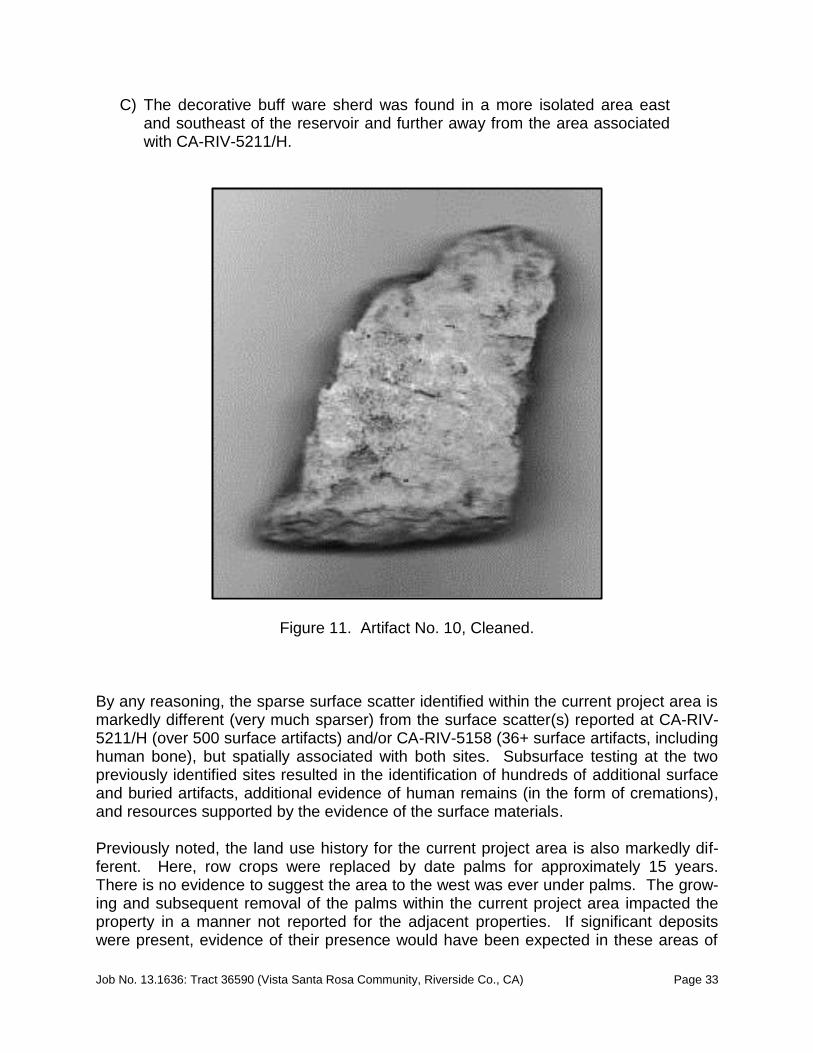
Artifact No. 7: Ceramic Sherd Artifact No. 7 is another small sherd identified as a brown ware with a red interior slip. Measuring 2.7 cm x 1.9 cm x .6 cm, this small sherd was identified at UTM coordinates and collected. There were no distinguishing characteristics and the item was too small to suggest vessel type. There is no evidence of burning. Artifact No. 8: Ceramic Sherd Artifact No. 8 is an irregularly shaped Tizon Brown sherd measuring 3.4 cm x 1.5 cm x .6 cm. Identified at UTM coordinates and collected, there were no distinguishing char-acteristics and the item was too small to suggest vessel type. There is no evidence of burning. Artifact No. 9: Ceramic Sherd Artifact No. 9 is a triangularly shaped brown ware sherd measuring 3.7 cm x 3.0 cm x .8 cm. Variation in the thickness of the sherd suggests this fragment may be a portion from an area near the base (but not the base). Identified at UTM coordinates and col-lected, there were no distinguishing characteristics and the item was too small to sug-gest vessel type. There is no evidence of burning. Artifact No. 10: Ceramic Sherd Artifact No. 10 is actually represented by two sherds recovered from an area of approx-imately four square meters. The smaller sherd is similar to others recovered from the property – brown ware with red slip, but no distinguishing markings. This sherd meas-ured 2.2 cm x 2.0 cm x .5 cm. The second item was markedly different than the others. It was identified east/south-east of the reservoir (not near the reservoir) and separated from the other pieces of ce-ramic both by location and type. In this case, the sherd was identified as a thick buff ware with measurements of 6.6 cm x 4.2 cm x .8 cm. The nature of the sherd suggests it was from a relatively large vessel, but no other fragments were identified to verify the vessel style. Found with the interior facing up, McKenna et al. found the exterior of this buffware sherd (facing down in the soil) to exhibit a textured surface consisting of a symmetrical series of small, circular indentations in consistent with a corrugated vessel, but actual design elements (Figures 10 and 11). Without the soil encrusted on the sherd, the decorative elements were not overt. Without additional data, McKenna et al. is tentatively identifying this sherd as a Salton Buff ware and it may have had some specialized use, given the surface decoration.

Job No. 13.1636: Tract 36590 (Vista Santa Rosa Community, Riverside Co., CA) Page 32
Figure 10. Artifact No. 10 in situ. Similar sherds may be within the collection from CA-RIV-5211/H, but this will require verification. There is no evidence of this piece being burned and there were no other fragments in the area to suggest this sherd is within an area that will add to the collec-tion. To date, this is a rather unique piece, but not necessarily as significant piece, lack-ing the necessary archaeological context for evaluation. These two sherds were recov-ered by UTM coordinates as a single point. Summary of Prehistoric Archaeological Resources The recent field investigations resulted in the identification of twelve prehistoric artifacts at nine locations (including one lithic artifact and eleven sherds), no features, and no evidence of any human remains. Some additional small fragments of ceramics were also noted, but not recovered. The surface was intensively surveyed and the artifacts summarized above were found to occur in three contexts:
A) The shell button and single lithic artifact were found near Avenue 61;
B) A small cluster of sherds was identified in the area mid-way between the reservoir and Avenue 61; near the western boundary of the property near the mapped eastern boundary of CA-RIV-5211/H; and
Job No. 13.1636: Tract 36590 (Vista Santa Rosa Community, Riverside Co., CA) Page 33
C) The decorative buff ware sherd was found in a more isolated area east and southeast of the reservoir and further away from the area associated with CA-RIV-5211/H.
Figure 11. Artifact No. 10, Cleaned. By any reasoning, the sparse surface scatter identified within the current project area is markedly different (very much sparser) from the surface scatter(s) reported at CA-RIV-5211/H (over 500 surface artifacts) and/or CA-RIV-5158 (36+ surface artifacts, including human bone), but spatially associated with both sites. Subsurface testing at the two previously identified sites resulted in the identification of hundreds of additional surface and buried artifacts, additional evidence of human remains (in the form of cremations), and resources supported by the evidence of the surface materials. Previously noted, the land use history for the current project area is also markedly dif-ferent. Here, row crops were replaced by date palms for approximately 15 years. There is no evidence to suggest the area to the west was ever under palms. The grow-ing and subsequent removal of the palms within the current project area impacted the property in a manner not reported for the adjacent properties. If significant deposits were present, evidence of their presence would have been expected in these areas of

Job No. 13.1636: Tract 36590 (Vista Santa Rosa Community, Riverside Co., CA) Page 34
high impact from disking, tree removal, and recent vegetation removal. Such evidence was not identified, suggesting the project area is peripheral to the more significant com-ponents of CA-RIV-5211/H, but still sensitive for buried resources. McKenna et al. collected a sample of the artifacts identified during the field survey. Specifically, they include one button, one lithic, and eleven sherds. These items are temporarily curated at the offices of McKenna et al. in Whittier, California. The prehis-toric items are considered part of the overall CA-RIV-5211/H site collection. Therefore, the materials should be added to the larger collections already recovered from this site. McKenna et al. proposes to submit these items for curation in conjunction with the col-lections of CRM Tech and/or Applied EarthWorks, Inc., but not until the Phase II studies are undertaken (see later discussion).
CONCLUSIONS AND RECOMMENDATIONS McKenna et al. has tentative concluded that the sparse scatter of ceramics (and one lithic artifact) constitute a peripheral scatter associated with CA-RIV-5211/H and outside the core area of the site – which is to the west of the project area. As such, all identified artifacts, with the exception of the isolated buffware sherd (Isolate No. 10) are consid-ered part of CA-RIV-5211/H and reported as such in the updated site record. The iso-lated buffware sherd has been recorded as an isolated find. Despite this preliminary interpretation of the materials, McKenna et al. emphasizes that this conclusion is based on surface evidence, only, and the area should still be consid-ered highly sensitive for buried cultural deposits and more significant remains until proven otherwise. There may still be significant resources comparable to CA-RIV-5211/ H within the project area. The relative sensitivity of the area to yield significant deposits, including addi-tional cremations, should not be ignored or downplayed. Therefore, McKenna et al. is making recommendations for additional studies (Phase II testing) prior to the proposed development of the property as a residential community. McKenna et al. is recommending the proponent of this residential development conduct an extended Phase I/Phase II testing program to determine whether or not additional components of CA-RIV-5211/H exist within the project area. The testing program should emphasize that portion of the property due east of the previously mapped boundaries of CA-RIV-5211/H (south of the reservoir and near the western property boundary). Although the testing can be completed in a number of ways, McKenna et al. is recommending the testing include controlled trenching, shovel scrapes, and con-trolled excavation units. The trenching and units should be excavated to a minimum depth of one meter, unless the trenching program suggests deeper excavations are warranted. The testing program should include analysis of recovered materials and a comprehensive evaluation that includes incorporating this data into the overall descrip-tion and finding related to CA-RIV-5211/H. The proposed testing plan must insure

Job No. 13.1636: Tract 36590 (Vista Santa Rosa Community, Riverside Co., CA) Page 35
compliance and concurrence with the policies of the archaeological profession, County and the local Native American representatives. This level of testing should provide information necessary to address the need, if any, for a Phase III data recovery program. Unlike the program completed by Applied Earth Works, Inc. during grading monitoring (fieldwork in 2005-06 and report completed in 2010), the Phase II testing and Phase III data recovery (if needed) can be done prior to construction activities and lessen impacts to the resources. The testing program should incorporate Native American participation, given the proximity of the human remains. Regardless of the results, the proponent should be prepared to have the project area monitored during any and all earthmoving activities related to the proposed develop-ment.
Monitoring The monitoring program recommended above is justified by the relative level of sensitiv-ity for the project area to yield significant archaeological resources and must include both professional archaeological and Native American participation. There is also a rel-atively high level of sensitivity for paleontological resources and, therefore, if the pro-posed property preparation for development exceeds the relative depth(s) of the young-er alluvium and impacts older alluvium (fossil bearing) deposits, a paleontological moni-toring program must also be conducted in accordance with County policies and guide-lines. The extent and duration of the monitoring program will be dependent upon the proposed grading schedule and relative findings. Therefore, it can be better defined once the grading plan is developed.
CERTIFICATION CERTIFICATION. I hereby certify that the statements furnished above and in the at-tached exhibits present the data and information required for this archaeological report, and that the facts, statements, and information presented are true and correct to the best of my knowledge and belief. _________________ __________________________________________________ Date Jeanette A. McKenna, Riverside County Reg. No. 161

Job No. 13.1636: Tract 36590 (Vista Santa Rosa Community, Riverside Co., CA) Page 36
REFERENCES
Aschmann, H. 1959 “The Evolution of a Wild Landscape and Its Persistence in Southern Califor-
nia.” Association of American Geographers Annals 49(3), Part 2:34-56. Ballester, Daniel 2002 Primary Record: 33-11570 (CA-RIV-6895). On File, University of California,
Riverside, Eastern Information Center, Riverside, California. 2002 Primary Record: 33-17247 (CA-RIV-8968). On File, University of California,
Riverside, Eastern Information Center, Riverside, California. 2002 Primary Record: 33-17248 (CA-RIV-8969). On File, University of California,
Riverside, Eastern Information Center, Riverside, California. 2002 Primary Record: 33-17249 (CA-RIV-8970). On File, University of California,
Riverside, Eastern Information Center, Riverside, California. 2003 Continuation Sheet: 33-01343. On File, University of California, Riverside,
Eastern Information Center, Riverside, California. 2003 Continuation Sheet: 33-05212 (CA-RIV-5212). On File, University of Cali-
fornia, Riverside, Eastern Information Center, Riverside, California. 2003 Continuation Sheet: 33-12955 (CA-RIV-7204). On File, University of Cali-
fornia, Riverside, Eastern Information Center, Riverside, California. 2005 Continuation Sheet: CA-RIV-005158. On File, University of California, Riv-
erside, Eastern Information Center, Riverside, California. Barrows, David P. 1900 The Ethno-botany of the Cahuilla Indians of Southern California. Chicago
Press. (Reprinted by the Malki Museum Press, 1976). Bean, Lowell John 1978 “Cahuilla.” In: Handbook of North American Indians, Volume 8: California.
Edited by R.F. Heizer, pp. 575-587. Smithsonian Institution, Washington, D.C.
Bean, Lowell J. and Harry Lawton 1965 The Cahuilla Indians of Southern California. Malki Museum Press, Banning,
California.

Job No. 13.1636: Tract 36590 (Vista Santa Rosa Community, Riverside Co., CA) Page 37
Bean, Lowell John and W.M. Mason 1962 Diaries and Account of the Romero Expeditions in Arizona and California,
1823-1826. The Desert Museum, Palm Springs, California. Bean, Lowell J. and Katherine Siva Saubel 1972 Temalpakh: Cahuilla Indians Knowledge and Usage of Plants. Malki Muse-
um Press, Banning. Bettinger, Robert L. and R.E. Taylor 1974 “Suggested Revisions in Archaeological Sequence of the Great Basin in In-
terior Southern California.” Nevada Archaeological Survey Research Paper 5:1-26.
Blake, W.P. 1956 “Geological Report.” In: Reports of Exploration in California for Railroad
Routes to Connect with Routes Near the 35th and 32d Parallels of North Lat-itude, by. Lt. R.S. Williamson. Corps of Topographic Engineers, Reports of Explorations and Surveys to Ascertain the Most Practicable and Economical Route for a Railroad from the Mississippi River to the Pacific Ocean, Made Under the Direction of the Secretary of War in 1853-1854, Volume 5. Bev-erly Tucker, Printer, Washington, D.C.
Brock, James 2003 Phase I Cultural Resources Assessment of a 28.73 Acre Property at Mon-
roe Street and Avenue 61, City of La Quinta, Riverside County, California. On File, University of California, Riverside, Eastern Information Center, Riv-erside, California.
2003 Primary Record: 33-12757. On File, University of California, Riverside,
Eastern Information Center, Riverside, California. California Environmental Quality Act (CEQA) 1999 Cultural Resources Element. (as amended). Campbell, Elizabeth W. Crozer and William H. Campbell 1937 “The Archaeology of Pleistocene Lake Mohave.” Southwest Museum Paper
No. 11. Los Angeles, California. Chace, Paul G. 1996 Historic Resource Evaluation Report, The Old Avenue 52, City of La Quinta.
On file, University of California, Riverside, Eastern Information Center. Coke Wood, R 1968 Point of Historical Interest Riv-015. On File, University of California, River-
side, Eastern Information Center, Riverside, California.

Job No. 13.1636: Tract 36590 (Vista Santa Rosa Community, Riverside Co., CA) Page 38
Curtis, E.S. 1926 The North American Indian, Volume 15. The University Press, Cambridge,
MA. Davis, Emma Lou, C.W. Brott, and D.L. Weide 1969 “The Western Lithic Co-Tradition.” San Diego Museum Paper No. 6. San
Diego, California. Demcak, Carol 2005 Primary Record: 33-14798. On file, University of California, Riverside,
Eastern Information Center, Riverside, California. Demcak, Carol and Sue A. Wade 2005 Report of Phase II (Test Level) Archaeological Investigations at CA-RIV-
5211/H, TTM 31732, City of La Quinta, Riverside County, California. On File, University of California, Riverside, Eastern Information Center, River-side, California.
de Munck, Victor 1989 Cultural Resource Assessment of Massey Sand and Gravel Pits, Indio, Cali-
fornia. On file, University of California, Riverside, Eastern Information Cen-ter, Riverside, California.
Desautels, Roger J. 1979 Archaeological Survey Report on the O’Neal Property, Coachella Valley,
Riverside County, California. On File, University of California, Riverside, Eastern Information Center, Riverside, California.
Dibble, T.W., Jr. 1954 “Geology of the Imperial Valley Region, California.” Geology of Southern
California. California Division of Mines and Geology Bulletin 170:13-28. Everson, Dicken 1991 Cultural Resources Assessment: Tentative Parcel 26730, Valerie, Coachella
Valley, Riverside County, California. On File, University of California, River-side, Eastern Information Center, Riverside, California.
Gallegos, Dennis, John Cash, E.L. Davis, Gary Lowe, Frank Norris and Jay Thesken 1979 Cultural Resources Inventory of the Central Mojave and Colorado Desert
Regions, California. On File, University of California, Riverside, Eastern In-formation Center, Riverside, California.
Gallegos, Dennis, Carolyn Kyle, Roxie Phillips, Andrew Pigniolo 1987 Archaeological Site Record: CA-RIV-5212. On File, University of California,
Riverside, Eastern Information Center, Riverside, California.

Job No. 13.1636: Tract 36590 (Vista Santa Rosa Community, Riverside Co., CA) Page 39
1987 Archaeological Site Record: CA-RIV-5211. On File, University of California, Riverside, Eastern Information Center, Riverside, California.
1987 Archaeological Site Record: CA-RIV-5158. On File, University of California,
Riverside, Eastern Information Center, Riverside, California. Gudde, Erwin G. 1949 1,000 California Place Names: Their Origins and Meaning. University of
California Press. Berkeley, California. Gunther, Jane Davies 1984 Riverside County, California. Place Names: Their Origins and Their Stories.
Rubidoux Printing, Inc., Riverside. Hall, Mathew C. and James B. Barker 1975 Background to the Prehistory of the El Paso/Red Mountain Desert Regions.
On File, University of California, Riverside, Eastern Information Center, Riv-erside, California.
Hamilton, (unk.) 1961 Cited in Padon 1984. Hogan, Michael, Bai Tang, and Mariam Dahdul 2005 Archaeological Monitoring Report, The Coral Mountain Expansion Project,
City of La Quinta, Riverside County, California. On File, University of Cali-fornia, Riverside, Eastern Information Center, Riverside, California.
Hogan, Michael, Bai Tang, Mariam Dahdul, Harry Quinn, and Daniel Ballester 2005 Final Report of Results and Findings, Archaeological Testing, and Mitigation
Program at the Coral Mountain Expansion Project, City of La Quinta, River-side County, California. On File, University of California, Riverside, Eastern Information Center, Riverside, California.
Hooper, Lucille 1920 “The Cahuilla Indians.” Studies in Cahuilla Culture, pp. 41-106. Malki Mu-
seum Press, Banning. Jertberg, Patricia R. 1982 Archaeological Salvage Investigation of CA-RIV-1180, Locus II on Dune La
Quinta Parcel. On File, University of California, Riverside, Eastern Infor-mation Center, Riverside, California.
Keller, Jean 1993 A Phase I Archaeological Assessment of Tentative Parcel Map 27430, 40
Acres of Land near Valerie, Riverside County, California. On File, Universi-ty of California, Riverside, Eastern Information Center, Riverside, California.

Job No. 13.1636: Tract 36590 (Vista Santa Rosa Community, Riverside Co., CA) Page 40
Keswick, Jan, Chris Holbeck, Charlotte Hunter, John Emerson 1999 Primary Record: 33-8950 (CA-RIV-6336/H). On File, University of Califor-
nia, Riverside, Eastern Information Center, Riverside, California. King, Chester and Dennis Casebrier 1976 Background to the Historic and Prehistoric Resources of the East Mojave
Desert Region. On File, University of California, Riverside, Eastern Infor-mation Center, Riverside, California.
Kroeber, Alfred L. 1925 Handbook of the Indians of California. Bureau of American Ethnology Bulle-
tin 78, Washington, D.C. 1976 Handbook of the Indians of California. Dover Publications, Inc. New York Love, Bruce 1990 Cultural Resources Assessment - La Quinta Shores Project, Coachella Val-
ley, Riverside County. On File, University of California, Riverside, Eastern Information Center, Riverside, California.
1990 Cultural Resource Assessment: GPA 287, Oak Shadows, Myoma. On file,
University of California, Riverside, Eastern Information Center, Riverside, California.
1998 Cultural Resources Report: Coral Mountain Project, Coachella Valley, Riv-
erside County, California. On File, University of California, Riverside, East-ern Information Center, Riverside, California.
1998 Primary Record: CA-RIV-273/1343. On File, University of California, River-
side, Eastern Information Center, Riverside, California. 1998 Primary Record: CA-RIV-5158. On File, University of California, Riverside,
Eastern Information Center, Riverside, California. 1998 Primary Record: CA-RIV-5211/H. On File, University of California, River-
side, Eastern Information Center, Riverside, California. 1998 Primary Record: CA-RIV-5212. On File, University of California, Riverside,
Eastern Information Center, Riverside, California. 1998 Primary Record: CA-RIV-6115. On File, University of California, Riverside,
Eastern Information Center, Riverside, California. 1998 Primary Record: 33-8958. On File, University of California, Riverside, East-
ern Information Center, Riverside, California.

Job No. 13.1636: Tract 36590 (Vista Santa Rosa Community, Riverside Co., CA) Page 41
1998 Primary Record: 33-8959. On File, University of California, Riverside, East-ern Information Center, Riverside, California.
1998 Primary Record: 33-8962. On File, University of California, Riverside, East-
ern Information Center, Riverside, California. 1998 Primary Record: 33-8965. On File, University of California, Riverside, East-
ern Information Center, Riverside, California. 1998 Primary Record: 33-8966. On File, University of California, Riverside, East-
ern Information Center, Riverside, California. 1998 Primary Record: 33-8967. On File, University of California, Riverside, East-
ern Information Center, Riverside, California. 1998 Primary Record: 33-8968. On File, University of California, Riverside, East-
ern Information Center, Riverside, California. 1998 Primary Record: 33-8969. On File, University of California, Riverside, East-
ern Information Center, Riverside, California. 1998 Primary Record: 33-8970. On File, University of California, Riverside, East-
ern Information Center, Riverside, California. 1998 Primary Record: 33-8971. On File, University of California, Riverside, East-
ern Information Center, Riverside, California. 1998 Primary Record: 33-8973. On File, University of California, Riverside, East-
ern Information Center, Riverside, California. 1998 Primary Record: 33-8974. On File, University of California, Riverside, East-
ern Information Center, Riverside, California. 1998 Primary Record: 33-8975. On File, University of California, Riverside, East-
ern Information Center, Riverside, California. 1998 Primary Record: 33-8976. On File, University of California, Riverside, East-
ern Information Center, Riverside, California. 1998 Primary Record: 33-8977. On File, University of California, Riverside, East-
ern Information Center, Riverside, California. 1998 Primary Record: 33-8978. On File, University of California, Riverside, East-
ern Information Center, Riverside, California.

Job No. 13.1636: Tract 36590 (Vista Santa Rosa Community, Riverside Co., CA) Page 42
1998 Primary Record: 33-8979. On File, University of California, Riverside, East-ern Information Center, Riverside, California.
1998 Primary Record: 33-8980. On File, University of California, Riverside, East-
ern Information Center, Riverside, California. 1998 Primary Record: 33-8981. On File, University of California, Riverside, East-
ern Information Center, Riverside, California. 1998 Primary Record: 33-8982. On File, University of California, Riverside, East-
ern Information Center, Riverside, California. 1998 Primary Record: 33-8983. On File University of California, Riverside, East-
ern Information Center, Riverside, California. 1998 Primary Record: 33-8984. On File, University of California, Riverside, East-
ern Information Center, Riverside, California. 1998 Primary Record: 33-8985. On File, University of California, Riverside, East-
ern Information Center, Riverside, California. 1998 Primary Record: 33-8986. On File, University of California, Riverside, East-
ern Information Center, Riverside, California. 1998 Primary Record: 33-8987. On File, University of California, Riverside, East-
ern Information Center, Riverside, California. 1998 Primary Record: 33-8989. On File, University of California, Riverside, East-
ern Information Center, Riverside, California. 1998 Primary Record: 33-8990. On File, University of California, Riverside, East-
ern Information Center, Riverside, California. 1998 Primary Record: 33-8991. On File, University of California, Riverside, East-
ern Information Center, Riverside, California. 1998 Primary Record: 33-8992. On File, University of California, Riverside, East-
ern Information Center, Riverside, California. Love, Bruce, Adrian Sanchez Moreno, and Michael Hogan 2000 Historical/Archaeological Resources Survey Report, Granite Construction
Surface Mining Permit No. 176, Revision No. 1, near the Community of My-oma, Riverside County, California. On file, University of California, River-side, Eastern Information Center, Riverside, California.

Job No. 13.1636: Tract 36590 (Vista Santa Rosa Community, Riverside Co., CA) Page 43
Love, Bruce and Bai “Tom” Tang 1996 Cultural Resources Report: RV Showcase Specific Plan, City of Indio, Riv-
erside County, California. On File, University of California, Riverside, East-ern Information Center, Riverside, California.
Macko, Michael 1990 Archaeological Resource Assessment of the Proposed Vista Santa Rosa
Planned Community, City of La Quinta, Riverside County, California. On file, University of California, Riverside, Eastern Information Center.
McDougall, Dennis, Vanessa Mirro, D. Earle, L. Bean, J. Toenjes, S. Griset, J. Eddy, D. Harro, R. McKim, K. Abdo-Hintzman, M. Mirro, V. Popper, J. Polanich, and S. Gust 2010 Emergency Phase III Data Recovery Excavations at CA-RIV-5211/H: A Late
Prehistoric Cemetery in the Coachella Valley, California. On file, McKenna et al., Whittier, California.
McGinnis, Patrick 2006 Cultural Resource Survey Report of 30-Acres for the Proposed Desert
Ranch Development, Riverside County, California. On File, University of California, Riverside, Eastern Information Center, Riverside, California.
2006 Cultural Resource Survey Report of 80-Acres for the Proposed Luna Vista
Development, Riverside County, California. On File, University of California, Riverside, Eastern Information Center, Riverside, California.
2006 Primary Record: 33-16995. On File, University of California, Riverside,
Eastern Information Center, Riverside, California. 2006 Primary Record: 33-16997. On File, University of California, Riverside,
Eastern Information Center, Riverside, California. 2006 Primary Record: 33-16998. On File, University of California, Riverside,
Eastern Information Center, Riverside, California. McKenna, Jeanette A. 1997 In-House Letter Report: The Centreat Project Area Resources. On file, Im-
pact Sciences, Chino Hills, California. 2002 A Phase I Cultural Resources Investigation of Approximately 1000 Acres
Located in the City of Indio, Riverside County, California. On file, McKenna et al., Whittier, California.
2006 A Phase I Cultural Resources Investigation of the Vincent N. Clark Property,
Assessor Parcel No. 750-300-004-6, Approximately 5 Acres in the City of Indio, Riverside County, California. On file, McKenna et al., Whittier, Cali-fornia.

Job No. 13.1636: Tract 36590 (Vista Santa Rosa Community, Riverside Co., CA) Page 44
Mirro, Michael and Tracy Formica 2007 Phase I Cultural Resources Investigation of 76.76 Acres for Tentative Tract
Map 35238, La Quinta, Riverside County, California. On File, University of California, Riverside, Eastern Information Center, Riverside, California.
Munz, Phillip 1974 A Flora of California. University of California Press, Berkeley. Munz, Phillip A. and D.D. Keck 1949 “California Plant Communities.” El Aliso 2:87-105. 1950 “California Plant Communities - A Supplement.” El Aliso 2:199-202. Norris, Robert M. and Robert W. Webb 1990 Geology of California. John Wiley & Sons, Inc., New York. Office of Historic Preservation 1989 Archaeological Resources Management Reports, Guidelines for Content
and Format. OHP, Sacramento, California. Padon, Beth 1984 Archaeological Resource Assessment La Quinta Hotel and Golf Club, Riv-
erside County, California. On file, University of California, Riverside, Eastern Information Center, Riverside, California.
1984 Supplemental Archaeological Assessment Oak Tree West Project, River-
side County. On file, University of California, Riverside, Eastern Information Center, Riverside, California.
1985 Archaeological Testing at Seven Archaeological Sites: Oak Tree West Pro-
ject, Riverside County, California. On file, University of California, River-side, Eastern Information Center, Riverside, California.
1985 Additional Archaeological Survey Within the La Quinta Hotel and Golf Club.
On file, University of California, Riverside, Eastern Information Center, Riv-erside, California.
Parr, Robert E. 1985 An Archaeological Assessment of the Proposed Wastewater Treatment
Plant Site and Pipeline Alignment, La Quinta Area of Riverside County, Cali-fornia. On file, University of California, Riverside, Eastern Information Cen-ter, Riverside, California.
Polan, K 1984 Archaeological Site Survey Record: CA-RIV-2758. On File, University of
California, Riverside, Eastern Information Center, Riverside, California.

Job No. 13.1636: Tract 36590 (Vista Santa Rosa Community, Riverside Co., CA) Page 45
Porter, Robert 2002 Primary Record: 33-17756. On File, University of California, Riverside,
Eastern Information Center, Riverside, California. 2002 Primary Record: 33-17754. On File, University of California, Riverside,
Eastern Information Center, Riverside, California. 2002 Primary Record: 33-17758. On File, University of California, Riverside,
Eastern Information Center, Riverside, California. Quill, Paul 2013 Personal Communication. Rogers, Malcolm 1939 “Early Lithic Industries of the Lower Basin of the Colorado River and Adja-
cent Desert Areas.” San Diego Museum Papers No. 3. San Diego, Califor-nia.
1945 “An Outline of Yuman Prehistory.” Southwestern Journal of Anthropology 1
(2);167-198. 1953 Miscellaneous Field Notes - Riverside County. On file, University of Califor-
nia, Riverside, Eastern Information Center, Riverside, California. Ryan, R.M. 1968 Mammals of Deep Canyon, Colorado Desert, California. The Desert Muse-
um, Palm Springs, California. Smallwood, Josh 2004 Continuation Sheet: CA-RIV-5158. On File, University of California, River-
side, Eastern Information Center, Riverside, California. Strong, William D. 1929 “Aboriginal Society in Southern California.” University of California Publica-
tions in American Archaeology and Ethnology No. 26. Reprinted in 1972 by the Malki Museum Press, Banning, California.
Tang, Bai, Michael Hogan, Matthew Wetherbee, John Eddy, and Daniel Ballester 2005 Historical/Archaeological Resources Survey Report, the Enclave at La Quin-
ta, Near the City of La Quinta, Riverside County, California. On File, Uni-versity of California, Riverside, Eastern Information Center, Riverside, Cali-fornia.

Job No. 13.1636: Tract 36590 (Vista Santa Rosa Community, Riverside Co., CA) Page 46
Tang, Bai, Michael Hogan, Zachary X. Hruby, and Daniel Ballester 2006 Archaeological Monitoring of Grubbing Activities on Tentative Tract Map No.
32398, City of La Quinta, Riverside County, California. On File, University of California, Riverside, Eastern Information Center, Riverside, California.
Wallace, William J. (and Edith S. Taylor) 1962 “Prehistoric Cultural Development in the Southern California Desert.” Amer-
ican Antiquity 28:172-180. Warren, Claude N. and H.T. Orr 1978 “Approach and Process for Dating Lake Mojave Artifacts.” Journal of Cali-
fornia Anthropology 512:179-187. Washington, H. 1856 Government Land Office Map: Township 6 South, Range 7 East. On file,
Bureau of Land Management California Desert District Offices, Riverside, California.
Weide, Margaret L. and James B. Barker 1975 Background to the Prehistory of the Yuma Desert Region. On file, Universi-
ty of California, Riverside, Eastern Information Center. White, Robert S. and David Van Horn 1990 Archaeological Test-Level Investigations on the Citrus Course II-The Grove
Property near La Quinta, Riverside County, California. On File, University of California, Riverside, Eastern Information Center, Riverside, California.
Wilke, Philip J. 1972 Archaeological Site Survey Record: CA-RIV-1337. On File, University of
California, Riverside, Eastern Information Center, Riverside, California. 1972 Archaeological Site Survey Record: CA-RIV-1343. On File, University of
California, Riverside, Eastern Information Center, Riverside, California. 1976 Late Prehistoric Human Ecology at Lake Cahuilla, Coachella Valley, Califor-
nia. Ph.D. Dissertation, University of California, Riverside. 1978 “Late Prehistoric Human Ecology at Lake Cahuilla, Coachella Valley, Cali-
fornia.” University of California Archaeological Research Facility Contribu-tions No. 38, Berkeley, California.
1980 Archaeological Site Survey Record: CA-RIV-1343. On File, University of
California, Riverside, Eastern Information Center, Riverside, California.

Job No. 13.1636: Tract 36590 (Vista Santa Rosa Community, Riverside Co., CA) Page 47
1984 An Archaeological Assessment of the Burns Ranch and Adjacent Proper-ties, La Quinta, Riverside County. On File, University of California, River-side, Eastern Information Center, Riverside, California
1986 Archaeological Investigations at La Quinta, Salton Basin, Southeastern Cali-
fornia: Chapter 1. On File, University of California, Riverside, Eastern In-formation Center, Riverside, California
Wilke, Philip J. and Harry W. Lawton 1975 “Early Observations on the Cultural Geography of Coachella Valley. The
Cahuilla Indians of the Colorado Desert: Ethnohistory and Prehistory.” Bal-lena Press Anthropological Papers 3:9-43.
Yenne, William 1985 History of the Southern Pacific Railroad. Bonanza Books, California. Yohe, Robert M. 1984 An Archaeological Assessment of Tentative Tract 19836, La Quinta, River-
side County, California. On File, University of California, Riverside, Eastern Information Center, Riverside, California