a precise, low-cost rtk gnss system for uav applications · a precise, low-cost rtk gnss system for...
TRANSCRIPT

A PRECISE, LOW-COST RTK GNSS SYSTEM FOR UAV APPLICATIONS
W. Stempfhuber and M. Buchholz
Beuth Hochschule für Technik Berlin, University of Applied Sciences, Department III, Luxemburger Str. 10,
D-13353 Berlin, Germany, [email protected], [email protected]
KEY WORDS: RTK GNSS, Low-cost, Kinematic, UAVs, Machine Control, Single-Frequency-Receiver
ABSTRACT:
High accuracy with real-time positioning of moving objects has been considered a standard task of engineering geodesy for 10 to 15
years. An absolute positioning accuracy of 1-3 cm is generally possible worldwide and is further used in many areas of machine
guidance (machine control and guidance), and farming (precision farming) as well as for various special applications (e.g. railway
trolley, mining, etc.). The cost of the measuring instruments required for the use of geodetic L1/L2 receivers with a local reference
station amounts to approximately USD 30,000 to 50,000. Therefore, dual frequency RTK GNSS receivers are not used in the mass
market.
Affordable GPS/GNSS modules have already reached the mass market in various areas such as mobile phones, car navigation, the
leisure industry, etc. Kinematic real-time positioning applications with centimetre or decimetre levels could also evolve into a mass
product. In order for this to happen, the costs for such systems must lie between USD 1,000 to 2,000. What exactly low-cost means
is determined by the precise specifications of the given individual application.
Several university studies in geodesy focus on the approach of high-accuracy positioning by means of single frequency receivers for
static applications [e.g. GLABSCH et. al. 2009, SCHWIEGER and GLÄSER 2005, ALKAN 2010, REALINI et. al. 2010, KORTH
and HOFMANN 2011]. Although intelligent approaches have been developed that compute a trajectory in the post-processing mode
[REALINI et. al., 2010], at present, there are only a very few GNSS Low-Cost Systems that enable real-time processing.
This approach to precise position determination by means of the computation of static raw data with single frequency receivers is
currently being explored in a research project at the Beuth Hochschule für Technik Berlin - and is being further developed for
kinematic applications. The project is embedded in the European Social Fund. It is a follow-up project in the area of static
positioning with single GNSS frequency receivers [KORTH and HOFMANN, 2011].
1. MOTIVATION 1
The exact positioning of moving objects within an accuracy 2
range of a few centimetres has been possible through geodetic 3
measuring sensors for approximately 15-20 years. With this, 4
one can distinguish between the systems for 3D-capture in 5
terrestrial (Total Stations or IMUs) and global processes 6
(GNSS). Nowadays, many applications for exact positioning 7
utilise geodetic RTK GNSS receivers. GPS single frequency 8
receivers with or without code corrections and with lower 9
accuracy standards are used for this. Today and as a rule, 10
kinematic applications at the centimetre level use geodetic 11
2 frequency receivers for the determination of a 3D-trajectory. 12
Many GNSS applications are not realisable due to the high cost 13
and the heavy weight of the measuring equipment. Therefore 14
today, the usage of RTK GNSS primarily limits itself to 15
applications in the areas of the machine control and guidance as 16
well as Precision Farming. 17
At the Beuth Hochschule für Technik Berlin – University of 18
Applied Sciences and within the scope of a research project, the 19
capabilities of single frequency receivers are verified and then 20
adapted and developed for special applications. This modular 21
GNSS System (see Figure 2) is based on the solution of the 22
L1-carried phase ambiguity. It is able to calculate centimetre- 23
exact, 3D-positions on a real-time basis and be output to in 24
interfaces. With this, different real-time processes can be 25
realised. An example is the control and guidance of small 26
Mindstorms NXT-model vehicle. Subsequent system structures 27
are necessary for this purpose. 28
International Archives of the Photogrammetry, Remote Sensing and Spatial Information Sciences, Volume XXXVIII-1/C22, 2011ISPRS Zurich 2011 Workshop, 14-16 September 2011, Zurich, Switzerland
289

Figure 1. RTK Mindstorms NXT-Control via the RTK GNSS Low-cost System
These models are able to conduct target tracking on a real-time
basis. Through the integration of other Mindstorms sensors,
such movement simulators can simulate actual applications very
realistically. This is currently being conducted in various, small
projects at the Beuth Hochschule für Technik Berlin –
University of Applied Sciences.
2. SYSTEM COMPONENTS OF THE LOW-COST
RTK GNSS
As a general rule, commercial GNSS products are available to
the user as a complete system. The approach of the research
project for the real-time solution and output of the L1-carried
phase ambiguity is based on a modular hard and software
approach. Aside from the various implemented GNSS boards
(z.B. ublox, Sky Traq, NovaTel, Hemisphere, Superstar, etc.)
and the different GNSS aerials, first and foremost, the RTK
software is a central component. More than 10 years ago, a
Matlab Freeware with the project name GPSLab [Zebhauser,
2000] was already available for static GPS measurements. Since
2006, the Japanese university project, RTKLIB, is freely
assessable for real-time applications [Takasu, 2008]. RTKLIB is
an Open Source software package for GNSS positioning. With
this programme, one can process and store raw GPS data on a
real-time basis as well as in post-processing. The software
package consists of several partially independent program
components. These are following modules:
RTKNavi GNSS Realtime Calculation and
NMEA Output,
RTKPost Post-processing Software,
RTKPlot Visualisation,
RTKConv Convert to RINEX Data and
pos2kml Create a Keyhole Markup
Language (KML)-Dataset
The solution of the L1-carried phase ambiguity uses the
approach of [Teunissen 1995] and [Chang 2005]. Building on
this component, overall systems were subsequently developed
with the Research Assistance V and VI.
WiFi Communication
Bluetooth
Communication
Local L1 Reference
(Cable, Radio or WiFi)
or Mobile Internet
(NTrip Data)
BT-Stick
NXT-Control and Calculation
(e.g. Matlab)
Mindstorms NXT Dozer with
the RTK Low-cost Receiver
RTK GNSS Software,
e.g. RTKNAVI
International Archives of the Photogrammetry, Remote Sensing and Spatial Information Sciences, Volume XXXVIII-1/C22, 2011ISPRS Zurich 2011 Workshop, 14-16 September 2011, Zurich, Switzerland
290
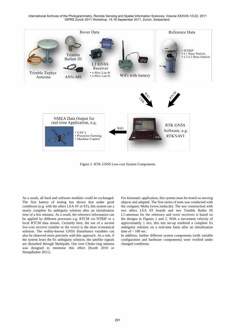
Figure 2. RTK GNSS Low-cost System Components
As a result, all hard and software modules could be exchanged. 1
The first battery of testing has shown that under good 2
conditions (e.g. with the ublox LEA 4T or 6T), this system ran a 3
nearly complete fix ambiguity solution after an initialization 4
time of a few minutes. As a result, the reference information can 5
be applied by different processes e.g. RTCM via NTRIP or a 6
local RTCM data stream. Certainly here, the use of a second 7
low-cost receiver (similar to the rover) is the most economical 8
solution. The widely-known GNSS disturbance variables can 9
also be observed more precisely with this approach. As a rule, if 10
the system loses the fix ambiguity solution, the satellite signals 11
are disturbed through Multipath. Our own Choke-ring antenna 12
was designed to minimise this effect [Korth 2010 or 13
Stempfhuber 2011]. 14
15
For kinematic application, this system must be tested on moving 16
objects and adapted. The first series of tests was conducted with 17
the company Moba (www.moba.de). The test construction with 18
two ublox LEA 6T boards and two Trimble Bullet III 19
L1-antennas for the reference and rover receivers is based on 20
the designs in Figures 1 and 2. With a movement velocity of 21
approximately 1 m/s, this test set-up rendered a complete fix 22
ambiguity solution on a real-time basis after an initialization 23
time of ~ 180 sec. 24
In addition, further different system components (with variable 25
configuration and hardware components) were verified under 26
changed conditions. 27
28
International Archives of the Photogrammetry, Remote Sensing and Spatial Information Sciences, Volume XXXVIII-1/C22, 2011ISPRS Zurich 2011 Workshop, 14-16 September 2011, Zurich, Switzerland
291

29
Figure 3. Results of the first Test Measurement at Moba
3. PRECISE 3D-POSITIONING OF UAVS
At the moment, nearly all GPS-supported UAV applications are
being used as a stand-alone or as a differential corrected code
solutions. Therefore, an absolute positioning of a moving model
helicopter was only possible in metres under good conditions at
the sub-metre level. The exact analysis and referencing of the
aerial image data still occurs through the use of exact control
points. This limits many UAV applications. Through the low
weight and the low cost of the low-cost RTK GNSS-System,
existing UAV GNSS receivers can be easily substituted with
these GNSS prototypes. The real-time data output occurs via the
standardised NMEA output protocol. Subsequent test
construction could be very simply realised for the initial test.
Figure 4. RTK GNSS Low-cost System based UAV-Control
Camera
GNSS-Receiver
WiFi Box
3D-Trajectory
Calculation
WiFi
Local L1 Reference
(Cable, Radio or WiFi)
Radio
Communication
UAV Control
Test Trolley
RTK GNSS Software,
e.g. RTKNAVI
or Mobile Internet
(NTrip Data)
International Archives of the Photogrammetry, Remote Sensing and Spatial Information Sciences, Volume XXXVIII-1/C22, 2011ISPRS Zurich 2011 Workshop, 14-16 September 2011, Zurich, Switzerland
292

Initial tests are planned concerning the 3D-directional stability
with different UAV systems. The 3D-trajectory of UAVs with
code-corrected GPS had already been verified with target-
tracking total station [Eisenbeiss and Stempfhuber, 2009]. With
an economical and very light L1 receiver (weight: ublox
receiver incl. ports and a waterproof housing 193g, the Bullet
III antenna is 179g plus the WiFi module incl. the data logger
with around 350g), this described approach could position the
absolute 3D-position in the area of a few centimetres on a real-
time basis.
4. OUTLOOK
Through this described system and the Open-Source Code
RTKNavi Calculation Software for the real-time solution of the
carried phase ambiguity, the possibility exists to control any
land-based or airborne objects on a real-time basis. In addition,
the analysis and the re-initialization can be optimised for the
appropriate motion sequences. Moreover, only the a priori
information from the flight planning and the airspeed are
necessary. Therefore, an efficient and stable positioning is
possible in addition to the RTKNavi parameter [Takasu, 2008].
From the modular system structure (different GNSS boards,
GNSS aerials, correction services, etc.), the influence of
disturbances can be minimised for each, individual application
and therefore, the overall system can be optimised. Presently,
this is being carried out on various applications in the described
research project. The availability of a stable fix ambiguity
solution can additionally be achieved through the introduction
of GLONASS on these small and economical OEM-Boards.
References
Alkan, R. M.:, Development of a Low-cost Positioning System
Using OEM GPS Receivers and Usability in Surveying,
Applications , FIG Congress 2010 Facing the Challenges –
Building the Capacity, Sydney, 2010.
Chang, X.-W., Yang, X. and Zhou, T.: MLAMBDA - A
modified LAMBDA method for integer least-squares
estimation, J. Geodesy, vol.79, 2005.
Eisenbeiss, H. Stempfhuber, W. and Kolb, M.:
Genauigkeitsanalyse der 3D-Trajektorie von Mini-UAVs,
Tagungsband der Deutschen Gesellschaft für Photogrammetrie
und Fernerkundung (DGPF) 18/2009.
Glabsch, J., Heunecke, O. and Schuhbäck, S.:
Hangüberwachungen mittels Low Cost GNSS im alpinen Raum
– Ansätze und Erfahrungen, ETH Zürich, AHORH 2009.
Korth, W. and Hofmann, U.: Softwareentwicklung für
Positionsbestimmung mit Satelliten, Abschlussbericht
Forschungsassistenz VI, 2011.
Realini, E., Yoshida, D., Reguzzoni, M. and Raghavan, V.:
Testing goGPS Low-Cost RTK Positioning With A Wen-Based
Track Log Management System, WebMGS 2010.
Schwieger, V. and Gläser, A.: Possibilities of Low Cost GPS
Technology for Precise Geodetic Applications. Proceedings on
FIG Working Week 2005, Kairo, 2005.
Stempfhuber, W. and Buchholz, M.: High-End and Low-Cost
RTK GNSS in Machine Control and Precision Farming
Applications, FIG Working Week 2011 Bridging the Gap
between Cultures, Marrakech, Morocco, 18-22 May 2011.
Takasu, T., and Yasuda A.: Evaluation of RTK-GPS
Performance with Low-cost Single-frequency GPS Receivers,
International Symposium on GPS/GNSS 2008, November 11-
14, Tokyo International Exchange Center, Japan 2008.
RTKLIB: An Open Source Program Package for RTK-GPS,
http://gpspp.sakura.ne.jp/rtklib/rtklib.htm
Teunissen, P. J. G.: The least-square ambiguity decorrelation
adjustment: a method for fast GPS ambiguity estimation, J.
Geodesy, vol.70, 1995.
Zebhauser, B.: Zur Entwicklung eines GPS-Programms für
Lehre und Tests unter besonderer Berücksichtigung der
Ambibuity Function Methode , DKG-Reihe C, Heft Nr. 523,
2000.
International Archives of the Photogrammetry, Remote Sensing and Spatial Information Sciences, Volume XXXVIII-1/C22, 2011ISPRS Zurich 2011 Workshop, 14-16 September 2011, Zurich, Switzerland
293