a preliminary structural model for the blue mountain ... · pdf fileand wnw-striking faults is...
TRANSCRIPT

GRC Transactions, Vol. 32, 2008
273
KeywordsBlue Mountain, Nevada, structural control, normal fault, oblique slip, dilatant zone, Great Basin
AbstrActThe Blue Mountain geothermal field is a blind geothermal
prospect (i.e., no surface hot springs) along the west flank of Blue Mountain in southern Humboldt County, Nevada. Development wells in the system have high flow rates and temperatures above 190ºC at depths of ~600 to 1,070 m. Blue Mountain is a small ~8-km-long east-tilted fault block situated between the Eugene Mountains and Slumbering Hills. The geothermal field occu-pies the intersection between a regional NNE- to ENE-striking, west-dipping normal-sinistral fault system, which bounds the west flanks of Blue Mountain and the Eugene Mountains, and a more local WNW-striking, SW-dipping normal-dextral fault on the southwest side of Blue Mountain. The WNW-striking fault appears to mark a large left step in the more regionally extensive northeasterly striking fault zone. Quaternary fault scarps, faceted spurs, and steep mountain fronts, with ~1,000 m of topographic relief, mark these faults. The NE-striking fault zone swings to a more easterly strike in the northern Eugene Mountains and in the northern part of Blue Mountain probably due to a strong ENE-striking fabric in the Triassic metasedimentary basement. In the vicinity of the geothermal field, the intersection between the NE- and WNW-striking faults is marked by multiple fault splays and fault intersections, which have generated a >1 km wide, westerly plunging zone of highly fractured, relatively permeable rock. The inferred kinematics of these fault zones further implies a dilatant, wedge-shaped zone at their intersection. Thus, the Blue Moun-tain geothermal field appears to be controlled by a dilatant fault intersection, partly induced by the influence of strong basement fabrics on the orientation of Neogene faults.
IntroductionAlthough volcanism generally ceased 10 to 3 Ma, the north-
western Great Basin contains abundant geothermal fields, many
with subsurface temperatures approaching or exceeding 200°C. The fields are particularly abundant in northern Nevada and neighboring parts of northeast California and southern Oregon (Coolbaugh et al., 2002; Coolbaugh and Shevenell, 2004; Faulds et al., 2004). The lack of recent volcanism suggests that upper crustal magmatism is not a source for most of the geothermal ac-tivity in this region. Regional assessments of structural controls show that N- to NE-striking faults (N0oE-N60oE) are the primary controlling structure for ~75% of geothermal fields in Nevada, and this control is strongest for higher temperature systems (Coolbaugh et al., 2002; Faulds et al., 2004). In the northwestern Great Basin, where the extension direction trends WNW, controlling faults generally strike NNE, approximately orthogonal to the extension direction (e.g., Faulds et al., 2006).
Although faults control most geothermal activity in the Great Basin, relatively few detailed investigations have been conducted on the specific structural controls of individual fields. Concep-tual structural models are therefore lacking for many geothermal fields in the region. Because knowledge of such structures can facilitate development of exploration strategies and selection of drilling targets, characterization of favorable structural settings for geothermal activity has recently begun through integration of geologic and geophysical data (e.g., Faulds et al., 2004, 2006; Vice et al., 2007). This work has shown that many fields occupy discrete steps in normal fault zones or lie in belts of intersecting, overlap-ping, and/or terminating faults. The favorable structural settings generally involve subvertical conduits of highly fractured rock along normal fault zones oriented approximately perpendicular to the least principal stress. In addition, most fields are associated with Quaternary faults (e.g., Bell and Ramelli, 2007). Although significant progress has been made in identifying favorable struc-tural settings for geothermal activity, full characterization awaits analysis of many additional fields throughout the Great Basin.
The purpose of this report is to present a preliminary structural model of the Blue Mountain geothermal field by integrating geo-logic and geophysical data from Blue Mountain with the regional geologic setting. The Blue Mountain geothermal field is one of the most promising geothermal prospects in the Great Basin and is currently under development by Nevada Geothermal Power. It
A Preliminary structural Model for the blue Mountain Geothermal Field,
Humboldt county, Nevada
James E. Faulds1 and Glenn Melosh2
1Nevada bureau of Mines and Geology, University of Nevada, reno, NV2Nevada Geothermal Power, Vancouver, bc

274
Faulds and Melosh
lies in southern Humboldt County ~30 km west of Winnemucca in north-central Nevada (Figure 1). Although substantial geologic work has been completed at Blue Mountain (e.g., Fairbank and Ross, 1999; Szybinski, 2007; Melosh et al., 2008), the structural con-trols on the geothermal system are still in question. This report is based on geologic reconnaissance in the Blue Mountain area and a review of pertinent, previously published and unpublished work (e.g., Willden, 1964; Thole and Prihar, 1998; Fairbank and Ross, 1999; Ross et al., 1999; Szybinski, 2007; Optim, 2007; Melosh et al., 2008).
blue Mountain Geothermal FieldThe Blue Mountain geothermal field is
a blind geothermal prospect (i.e., no surface hot springs) focused in a complex fault zone along the west flank of Blue Mountain (Fig-ure 1). It was originally discovered as a result of mineral exploration drilling in an area of intense silicification and alteration in the 1990s. Fluid chemical indicators from a warm aquifer prompted Nevada Geothermal Power to explore the geothermal potential of the area (Fairbank and Ross, 1999; Ross et al., 1999). Exploration work has included temperature
gradient holes, fluid geochemistry, two DOE-funded slim wells, full-sized exploration holes, a detailed gravity study, and a seismic reflection survey (Melosh et al., 2008).
Development wells in the geothermal system deliver fluids at high rates and temperatures above 190ºC from entries at depths of ~600 to 1,070 m (2000 to 3500 feet). A recent step-out well to the west targeting deep structure revealed high permeability at temperatures above 210ºC at 1737 m (5700 feet; Casteel et al., 2008). High temperature equilibration at 250ºC is evident in the fluid chemistry. Wells at the margins of the system to the east and south have limited flow, fluid temperatures around 180ºC, and broad temperature reversals at depth.
regional structural settingThe Blue Mountain field lies within the Basin and Range prov-
ince, where NNE-striking normal faults generally dominate the regional strain field. Major extension began in this region ~12-8 Ma (Colgan et al., 2004) and has persisted episodically to the pres-ent, as evidenced by Quaternary fault scarps bounding many of the ranges and recent seismic activity (e.g., Bell et al., 2004; Caskey et al., 2004). GPS geodetic data indicate that the current exten-sion direction trends west-northwest (e.g., Bennett et al., 2003; Hammond and Thatcher, 2004), approximately perpendicular to the predominant north-northeast trend of major range-front faults in the northern Great Basin. Most of the fault blocks in the Blue Mountain region are tilted gently to moderately eastward and are bounded by major west-dipping normal fault zones (Figure 1; Colgan et al., 2004). Mountain ranges generally trend north- to north-northeast, parallel to the main range-bounding faults, and exceed 20 km in length (e.g., Eugene Mountains, Santa Rosa Range, and Sonoma Range).
10 km
Eug
ene
Mts
Eas
t Ran
ge
Krum Hills
Jack
son
Mts
Son
oma
Ran
ge
Gra
ss V
alle
y
Par
adis
e V
alle
y
Des
ert V
alle
y
Blue M
t
Silv
er S
tate
Val
ley
San
ta R
osa
Ran
ge
San
ta R
osa
Ran
ge
Slu
mbe
ring
Hill
s
Qui
nn R
iver
Val
ley
Bla
ck R
ock
Des
ert
Alpha MtAnt
elop
e R
ange
N
Winnemucca
Geothermal
Field
?
??
Major range-front fault, ball on downthrown side
Inferred or buried fault Blue Mountain geothermal field
General tilt direction of fault block
Figure 1. Generalized geologic map of the Blue Mountain region. Shaded areas represent bedrock exposures. Most of the ranges in this region are tilted gently to moderately eastward and bounded by major west-dipping normal faults. The Blue Mountain geothermal field is shown by the red circle ~30 km west of Winnemucca.
Blue MtDes
ert V
alle
y
Trms
Tb
30
N
1 km
Figure 2. Aerial view of Blue Mountain (from Google Earth, 2007). Note the prominent fault scarps bounding the southwest and northwest flanks of Blue Mountain. White dashed line on right marks the Tertiary nonconformity. Basaltic andesite flows (Tb) to the east of the nonconformity suggest that the Blue Mountain fault block is tilted ~30o east. Shaded red area shows the known extent of the geothermal field. Trms, Triassic metasedimentary rocks.

275
Faulds and Melosh
structural Framework – blue Mountain
Blue Mountain is a small ~8-km-long fault block situated between the Eugene Mountains and Slumbering Hills (Figure 1). Similar to other major fault blocks in the region, Blue Moun-tain is tilted moderately eastward. Major north-northeast- and west-northwest-striking, range-front faults bound the west and southwest flanks of Blue Mountain, respectively. These faults are marked by Quaternary fault scarps, faceted spurs, and steep mountain fronts with ~1,000 m of topographic relief (Figure 2). However, the north and east sides of Blue Mountain are more subdued and appear to lack recent fault scarps. Major questions remain concerning the kinematic evolution of the Blue Mountain fault block and the relations between the geometry and kinematics of the various fault zones and geothermal activity.
The predominant structural fabric of basement rocks is critical to understanding the kinematic evolution of most regions and may be particularly important in the Blue Mountain area. Here, the basement consists primarily of Triassic pelitic metasedimentary rocks, including argillite, slate, phyllite, and lesser interbedded quartzite. These rocks have a pronounced northeast- to east-northeast-striking, moderately northwest-dipping structural grain, as demonstrated by well-developed bedding. Northerly striking dikes of diorite and granodiorite of probable Cretaceous age locally cut the Triassic metasedimentary rocks but represent a small part (<5%) of exposed basement. In addition, the metasedi-mentary rocks are locally cut by abundant cm-scale quartz veins (Figure 3), which appear to be more common near the range-bounding Neogene fault on the west side of Blue Mountain. It is also noteworthy that a more northerly striking structural grain dominates basement rocks in much of the Eugene Mountains but gives way northward to a northeast- to east-northeast-striking, moderately northwest-dipping fabric in the northern part of that range directly south of Blue Mountain (Thole and Prihar, 1998). Thus, the basement fabric in the northern Eugene Mountains es-sentially parallels that at Blue Mountain.
Tertiary strata nonconformably overlie Mesozoic metamor-phic and crystalline basement throughout the region. In the Blue Mountain area, however, the Tertiary section is relatively thin and crops out only on the east side of Blue Mountain. The base of the Tertiary section, as exposed just east of Abel Canyon on the east side of Blue Mountain, consists of basaltic andesite flows and lesser volcaniclastic sandstone and conglomerate, all tilted gently to moderately (~20-40o) eastward about a north-northeast-trending axis (i.e., ~N25oE, 20-40oSE is a typical attitude in these rocks). The Tertiary section in this area appears to rest nonconformably on the Triassic metasedimentary rocks. These relations suggest that the entire Blue Mountain block has been tilted gently to moderately eastward since ~12 Ma. Removal of the east tilt of the block restores the fabric within the Triassic metasedimentary rocks to a somewhat steeper, more easterly strike.
As evidenced by its overall morphology, the most important fault zones bound the steep west-, northwest-, and southwest-facing flanks of Blue Mountain (Figure 2). These fault zones intersect or merge in the vicinity of the geothermal field. The west side is bounded by a complex north- to northeast-striking, moderately west-dipping normal-sinistral fault zone. This fault zone consists of several strands, which generally strike more northerly in the south near the geothermal field and northeast in the north. Several left steps in the mountain front along this zone suggest a left-lateral component of slip. Directly east of the geothermal field, however, a well exposed fault surface, which strikes N30oE and dips 45-50o west, contains striae indicative of normal slip (i.e., dip slip). In the vicinity of the geothermal field, many strands of this fault zone are marked by Quaternary scarps. Most of the scarps appear to die out northward, although sand dunes directly north of Blue Mountain may obscure the traces of some Quaternary faults. Depth to basement contours inferred from gravity data (Figure 4, overleaf) suggest that the main strand of this fault zone continues northward toward the west flank of the Slumbering Hills (Figure 1). However, several ENE-trending topographic scarps imply that this fault
zone also splays into ENE-striking sinistral-normal faults along the north side of Blue Mountain. The ENE-striking faults in this area may continue east-ward and merge with the southern end of the major west-dipping normal fault on the west flank of the Santa Rosa Range. Thus, the E-W trending Krum Hills, which stretch from just north of Winnemucca on the east to Blue Mountain on the west, may be bounded on the north by a transfer zone that relays strain from the west-dipping Santa Rosa fault zone, which accommodated ~8 km of normal slip (Colgan et al., 2004), to the west-dipping normal (± sinistral) faults on the west flanks of Blue Mountain and the Eugene Mountains (Figure 1).
The steep southwest flank of Blue Mountain (Figure 5, overleaf) is bounded by a major west-northwest-striking, southwest-dipping fault zone, which has probably accommodated normal-dextral motion. Although no fault surfaces were observed, the steep mountain front and abundant faceted spurs suggest a normal component of slip. As noted by Szybinski (2007), however, apparent dextral offset
Figure 3. Quartz veins invading Triassic metasedimentary rocks. Veins appear to be more abundant near the major fault bounding the northwest flank of Blue Mountain. Some of these veins may therefore be related to recent geothermal activity.
276
Faulds and Melosh
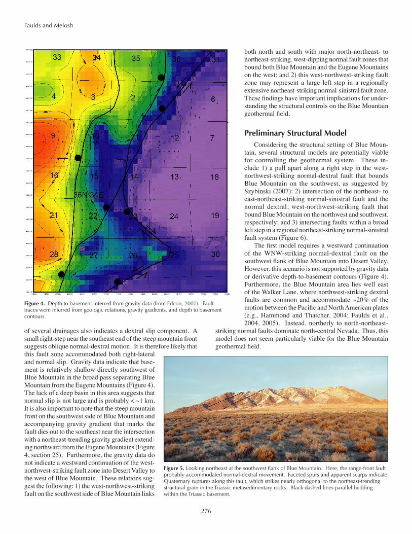
of several drainages also indicates a dextral slip component. A small right-step near the southeast end of the steep mountain front suggests oblique normal-dextral motion. It is therefore likely that this fault zone accommodated both right-lateral and normal slip. Gravity data indicate that base-ment is relatively shallow directly southwest of Blue Mountain in the broad pass separating Blue Mountain from the Eugene Mountains (Figure 4). The lack of a deep basin in this area suggests that normal slip is not large and is probably < ~1 km. It is also important to note that the steep mountain front on the southwest side of Blue Mountain and accompanying gravity gradient that marks the fault dies out to the southeast near the intersection with a northeast-trending gravity gradient extend-ing northward from the Eugene Mountains (Figure 4, section 25). Furthermore, the gravity data do not indicate a westward continuation of the west-northwest-striking fault zone into Desert Valley to the west of Blue Mountain. These relations sug-gest the following: 1) the west-northwest-striking fault on the southwest side of Blue Mountain links
both north and south with major north-northeast- to northeast-striking, west-dipping normal fault zones that bound both Blue Mountain and the Eugene Mountains on the west; and 2) this west-northwest-striking fault zone may represent a large left step in a regionally extensive northeast-striking normal-sinistral fault zone. These findings have important implications for under-standing the structural controls on the Blue Mountain geothermal field.
Preliminary structural ModelConsidering the structural setting of Blue Moun-
tain, several structural models are potentially viable for controlling the geothermal system. These in-clude 1) a pull apart along a right step in the west-northwest-striking normal-dextral fault that bounds Blue Mountain on the southwest, as suggested by Szybinski (2007); 2) intersection of the northeast- to east-northeast-striking normal-sinistral fault and the normal dextral, west-northwest-striking fault that bound Blue Mountain on the northwest and southwest, respectively; and 3) intersecting faults within a broad left step in a regional northeast-striking normal-sinistral fault system (Figure 6).
The first model requires a westward continuation of the WNW-striking normal-dextral fault on the southwest flank of Blue Mountain into Desert Valley. However, this scenario is not supported by gravity data or derivative depth-to-basement contours (Figure 4). Furthermore, the Blue Mountain area lies well east of the Walker Lane, where northwest-striking dextral faults are common and accommodate ~20% of the motion between the Pacific and North American plates (e.g., Hammond and Thatcher, 2004; Faulds et al., 2004, 2005). Instead, northerly to north-northeast-
striking normal faults dominate north-central Nevada. Thus, this model does not seem particularly viable for the Blue Mountain geothermal field.
Figure 4. Depth to basement inferred from gravity data (from Edcon, 2007). Fault traces were inferred from geologic relations, gravity gradients, and depth to basement contours.
Figure 5. Looking northeast at the southwest flank of Blue Mountain. Here, the range-front fault probably accommodated normal-dextral movement. Faceted spurs and apparent scarps indicate Quaternary ruptures along this fault, which strikes nearly orthogonal to the northeast-trending structural grain in the Triassic metasedimentary rocks. Black dashed lines parallel bedding within the Triassic basement.

277
Faulds and Melosh
Figure 7. Looking east-northeast at west flank of Blue Mountain, where multiple fault strands (shown by white dashed lines) connect the WNW-striking normal-dextral and NE-striking normal-sinistral fault zones on the southwest and northwest flanks of Blue Mountain, respectively. The geothermal system occurs at the intersection of the two fault systems, where enhanced dilation and intense fracturing has accommodated the deep circulation of fluids.
In the second model, the intersection between northeast-striking normal-sinistral and northwest-striking normal-dextral faults is compatible with available data. However, implicit in this model is the in-ference that the strike-slip component on these faults is dominant and that significant dilation results only from the fortuitous intersection of regionally extensive, strike-slip fault zones of opposing sense. The Blue Mountain region, however, is clearly dominated by west-northwest extension as opposed to strike-slip faulting (e.g., Colgan et al., 2004; Fosdick and Colgan, in press). Further, the west-northwest-trending fault does not appear to be a regionally extensive structure, although it is possible it connects southeastward with the major range-front fault bounding the west flank of the East Range (Figure 1).
The third model is preferred, because it honors both available data and is compatible with the regional geologic setting. The dominant fault zone in this model is the north-northeast- to east-northeast-striking, west-dipping normal-sinistral fault system that bounds the Eugene Mountains and Blue Mountain on the west (Figure 6). This fault zone swings to a more easterly strike in the northern Eugene Mountains probably due to a corresponding change in structural grain in the Triassic basement. Similarly, east-northeast-striking strands of this fault zone in the northern Blue Mountain area were also controlled by the strong fabric in the Tri-assic basement. This structural grain is not orthogonal, however, to the west-northwest-trending extension direction. Pure extension in this strain field would occur only on north-northeast-striking faults, whereas northeast- to east-northeast-striking faults would accommodate normal-sinistral motion. Although the regional stress field may favor north-northeast-striking normal faults, the strong basement fabric would tend to skew any developing nor-mal faults to more easterly strikes. Left steps in these fault zones may serve as adjustments, locally shifting the faults back to more northerly orientations that better accommodate regional extension. The left-lateral component on the main north-northeast-striking fault system combined with the regional strain field would, in turn, favor normal-dextral motion on northwesterly striking left steps, essentially generating small pull-aparts in the regional northeasterly striking fault system (Figures 1 and 6).
At Blue Mountain, the geothermal field occurs at the intersec-tion between the regional northeast-striking, west-dipping normal fault system and a major west-northwest-trending left step in that fault system (Figsures 6 and 7). Normal-sinistral slip on the northeast-striking fault zone and normal-dextral motion on the west-northwest-striking fault, combined with multiple fault inter-sections, would generate a relatively broad zone of both dilation and highly fractured, permeable rock favorable for deep circula-tion of fluids. At the onset of extension, relatively steeply dipping faults (~60-70o) probably characterized this system. However, ~30o of east-tilting of the Blue Mountain fault block may have rotated these faults to gentler dips. Newly formed faults would
5 km
Eugene Mts
Blue Mt
Desert Valley
N
50
55
50
60
70
80
75
30
Geoth
ermal
System
Tertiary basalts
Triassic meta-sedimentary rocks
Concealed fault
Probable faultQuaternary fault
Figure 6. Preferred structural model for the Blue Mountain geothermal system (shown in red). The field occurs at the intersection of NE-striking, normal-sinistral and a WNW-striking normal-dextral fault zones. The WNW-striking fault is probably a large left step in the more regionally extensive NNE- to NE-striking fault zone. The intersection of the two faults generates a focused area of dilation along the west flank of Blue Mountain. Also, numerous fault intersections between multiple fault strands produce a broad zone of highly fractured rock in this area. Collectively, these features favor deep circulation of fluids and therefore facilitate the geothermal activity.

278
Faulds and Melosh
tend to form at steeper dips, which may account for the steeply dipping strands of this fault system at shallow levels.
The key features at Blue Mountain may be the multiple, close-ly-spaced faults connecting the northeast- and west-northwest-striking fault zones within a dilatant zone. Collectively, this com-bination would generate a moderately to steeply, west-plunging conduit of highly fractured rock, which deeply circulating fluids could exploit. In the vicinity of the geothermal field, the multiple, closely-spaced fault scarps with variable trends (Figure 7; as com-pared to fewer more widely spaced scarps elsewhere in the Blue Mountain-Eugene Mountains area), the abundant silicification and alteration, and the ~1.5 km wide platform of relatively shal-low basement are all compatible with a broad relatively dilatant, complex fault zone. The distribution of probable Quaternary scarps indicates an ~1 km wide fault zone in this area.
In comparison to other geothermal fields in the Great Basin, the Blue Mountain system is probably more complex than either a simple step over in a normal fault zone (e.g., Desert Peak or Brady’s) or a pull apart between two strike-slip faults (e.g., Hinz et al., this volume). It may represent a slightly different setting than those previously described in the region (e.g., Faulds et al., 2006). The geometry and inferred kinematics at Blue Mountain attest to the potential influence of strong fabrics in basement rocks on the orientation of Neogene normal fault systems and how slight skew-ing in the orientation of such faults may generate major oblique-slip faults that can locally intersect to form discrete dilatant pockets of highly fractured rock favorable for the venting of hydrothermal fluids. The fact that the Blue Mountain system is currently blind, with no surface hot springs, is particularly noteworthy and prob-ably indicative of the large geothermal potential in this arid region. Although more work is needed to refine the structural model at Blue Mountain, the inferred structural setting may have applications to other geothermal fields elsewhere in the Great Basin.
AcknowledgmentsThis research was supported by the Nevada Geothermal
Power Company and the U.S. Department of Energy (DE-FG36-02ID14311). We thank Brian Fairbank and Andy Sabin for help-ful reviews of this manuscript. We also gratefully acknowledge fruitful discussions with Brian Fairbank and Mark Coolbaugh.
references citedBell, J.W., Caskey, S.J., Ramelli, A.R., and Guerrieri, L., 2004, Pattern and
rates of faulting in the central Nevada seismic belt, and paleoseismic evidence for prior belt-like behavior: Seismological Society of America Bulletin, v. 94, p. 1229-1254.
Bell, J.W., and Ramelli, A.R., 2007, Active faults and neotectonics at geother-mal sites in the western Basin and Range: Preliminary results: Geothermal Resources Council Transactions, v. 31, p. 375-378.
Bennett, R.A., Wernicke, B.P., Niemi, N.A., Friedrich, A.M., and Davis, J.L., 2003, Contemporary strain rates in the northern Basin and Range province from GPS data: Tectonics, v. 22, no. 2, p. 3-1 – 3-31.
Caskey, S.J., Bell, J.W., Ramelli, A.R., and Wesnousky, S.G., 2004, Historic Surface Faulting and Paleoseismicity in the Area of the 1954 Rainbow Mountain-Stillwater Earthquake Sequence, Central Nevada: Seismologi-cal Society of America Bulletin, v. 94, p. 1255-1275.
Casteel, J., G. Melosh, K. Niggemann, and B. Fairbank; 2008; Blue Mountain Step-Out Drilling Results; Geothermal Resources Council Transactions, v. 32, in press.
Colgan, J.P., Dumitru, T.A., and Miller, E.L., 2004, Diachroneity of Basin and Range extension and Yellowstone hotspot volcanism in northwestern Nevada: Geology, v. 32, no. 2, p. 121-124.
Coolbaugh, M.F., Taranik, J.V., Raines, G.L., Shevenell, L.A., Sawatzky, D.L., Minor, T.B., and Bedell, R., 2002, A geothermal GIS for Nevada: defining regional controls and favorable exploration terrains for exten-sional geothermal systems; Proceedings, Annual Meeting, Reno, NV., Sept. 22-25, 2002, Geothermal Resources Council Transactions, v. 26, p. 485-490.
Coolbaugh, M.F. and Shevenell, L.A., 2004, A method for estimating undis-covered geothermal resources in Nevada and the Great Basin: Geothermal Resources Council Transactions, v. 28, p. 13-18.
Fairbank, B. and Ross, H., 1999, Geology and temperature gradient surveys, the Blue Mountain geothermal discovery, Humboldt County, Nevada: Geothermal Resources Council Transactions, v. 23, p. 513-517.
Faulds, J.E., Coolbaugh, M., Blewitt, G., and Henry, C.D., 2004, Why is Ne-vada in hot water? Structural controls and tectonic model of geothermal systems in the northwestern Great Basin: Geothermal Resources Council Transactions, p. 649-654.
Faulds, J.E., Henry, C.D., and Hinz, N.H., 2005, Kinematics of the northern Walker Lane: An incipient transform fault along the Pacific – North American plate boundary: Geology, v. 33, no. 6, p. 505-508.
Faulds, J.E., Coolbaugh, M.F., Vice, G.S., and Edwards, M.L., 2006, Char-acterizing Structural Controls of Geothermal Fields in the Northwestern Great Basin: A Progress Report: Geothermal Resources Council Transac-tions, v. 30, p. 69-76.
Fosdick, J.C., and Colgan, J.P., in press, Miocene extension in the East Range, Nevada: Apatite (U-Th)/He and fission track dating of multiple episodes of normal faulting: Geological Society of American Bulletin.
Hammond, W.C., and Thatcher, W., 2004, Contemporary tectonic deforma-tion of the Basin and Range province, western United States: 10 years of observation with the Global Positioning System: Journal of Geophysical Research, v. 109, B08403, DOI: 10.1029/2003JB002746.
Hinz, N.H., Faulds, J.E., and Oppliger, G.L., 2008, Structural controls of Lee Hot Springs, southern Churchill County, western Nevada: A small pull-apart in the dextral shear zone of the Walker Lane: Geothermal Resources Council Transactions, v. 32, in press.
Melosh, G., Niggeman, K., and Fairbank, B., 2008, Geothermal drilling success at Blue Mountain, Nevada; Proceedings 33rd Workshop on Geothermal Reservoir Engineering, January 28-30, Stanford, California, SGP-TR-185, 5 p.
Optim, Inc., 2007, Active source seismic exploration and development at the Blue Mountain geothermal project, Humboldt County, Nevada: Unpub-lished report prepared for Desert Valley Gold, Inc., 32 p.
Ross, H., Langton, D., Fairbank, B., and Mackelprang, C., 1999, Electrical resistivity and self-potential surveys, Blue Mountain geothermal area, Ne-vada: Geothermal Resources Council Transactions, v. 23, p. 519-523.
Szybinski, Z.A., 2007, Revised structural setting of the Blue Mountain geothermal project area: Unpublished report for Nevada Geothermal Power, Inc., 48 p.
Thole, R.H., and Prihar, D.W., 1998, Geologic map of the Eugene Mountains, northwestern Nevada: Nevada Bureau of Mines and Geology Map 115, with accompanying text, 1:24,000 scale.
Vice, G.S., Faulds, J.E., Ehni, W.J., and Coolbaugh, M.F., 2007, Structural controls of a blind geothermal system in the northern Pyramid Lake area, northwestern Nevada: Geothermal Resources Council Transactions, v. 31, p. 133-137.
Willden, R., 1964, Geology and mineral deposits of Humboldt County, Ne-vada: Nevada Bureau of Mines and Geology Bulletin 59, 154 p.