a. project background and description - lged plan for...a. project background and description 1....
TRANSCRIPT

1
A. PROJECT BACKGROUND AND DESCRIPTION
1. Project Background
1. The participatory small scale water resource sector project intends to increase the agricultural production while reducing poverty in subproject area through sustainable stakeholder driven Small Scale Water Resources (SSWR) management system; and to internalize participatory processes through the strengthening of the Local Government Engineering Department’s (LGED’s) Integrated Water Resource Management Unit (IWRMU) to plan, implement, monitor and support sustainable SSWR development. LGED is the Project’s executing agency (EA). 2. The Project builds on lessons from previous ADB investments in the small-scale (less than 1,000 hectare [ha]) water resources sector; specifically, the Small-Scale Water Resources Development Sector Project (SSW 1), which was implemented from 1996 to 2002 and developed 280 subprojects in the western part of the country. Also, the Second Small-Scale Water Resources Development Sector Project (SSW 2), which commenced in 2002 and was completed in 2009 after developing 300 subprojects in 61 of 64 districts of Bangladesh. SSW 3 is the Participatory Small Scale Water Resources Sector Project (PSSWRSP), or ‘the Project’. 3. The project objectives will be achieved through the participation of stakeholders in identification, implementation, improvement and management of water management related infrastructures. The project infrastructure is diversified, including: re-excavation and improvement of Khals (channels, or rivulets); construction and supplementary irrigation in monsoon/dry season. In addition, suitable hydraulic structures will be constructed, wherever needed. 2. Description of the Subproject
4. The feasibility study of Shantosh para-Chatra Subproject was conducted in June 2012 during SSW under PSSWRSP, the subproject is planned for implementation during 2012. The detailed design (DD) was prepared in June 2012. As part of the Detailed Measurement Survey (DMS), Project Management Office (PMO) organized the census/socioeconomic survey (SES) to identify all affected persons (APs), their socioeconomic status, and to which extent they will be affected, including an assessment of their residential properties/assets in the locality.
5. The Shantosh para- Chatra Subproject is located between Latitudes 24° 50’ 0’N and 24° 55’0 N and Longitudes 88° 38’0” E to 88°39’ 7” E. The subproject site is about 8 km from Niamotpur Upazila Head quarters. The Subproject is bounded by a village road and a flood control embankment of Gabtoli along the north; while the is east side is bounded by a metalled road from Tuktuki Paika to Chatra and a earthen road from Chatra Hat. At the southern boundary, there are Gabtoli Road from Monarpara, and partly by Sib River covering the South side of Monarpara.The location of the subproject area in the Upazila base map is shown in Figure-1. A detailed map of the subproject showing existing infrastructure and planned interventions provided in Figure-2.

2
Figure 1 The location of the subproject area in the Upazila base map Figure :2 Detailed map of the subproject showing existing infrastructure and planned interventions

3
Figure :2 Detailed map of the subproject showing existing infrastructure and planned
interventions

4
3. Area and Location 6. The Shantosh para- Chatra subproject is located in 5(Five) Union namely 1.Chandas 2.Pranpur 3. Bhabicha 4.Valain 5.Chandan nagor of 3(Three) Upazila Name 1.Mohadebpur 2.Niamotpur 3.Manda District of Naogaon. The subproject is spread over 34(Thirty four) villages namely: 1.Akerapara 2.Lawdhanga 3.Monhorpur 4.Chandas 5.Jontoil 6.Paga 7.Hzrapur 8.Chakvalain 9.Ganta 10.Hator 11.Balubazar 12. Chakesbpur 13.Turukgram 14.Bnishor 15.Dhormopur 16.Paikora 17.Jinpur 18.Bilsedain 19.Kathalbari 20.Sedain 21.Karalipara 22.Koyas 23.Nakoin 24.Chapra 25.Shalalpur 26.Amoil 27.Kalpur 28.Gabtoli 29.Chakdewlia 30.Kornopur 31.Balkapara 32.Bamnahar 33.Valain & 34.Bamoin. 7. The subproject is located on the Right Bank of the Sib River. During early monsoon Flood water enter into the subproject area from the upland flow through santoshpara khal and causes drainage congestion. Pre-monsoon heavy shower sometimes inundate ripen HYV Boro crops during the harvesting stage and damage T. Aman crops due to Drainage congestion during the monsoon. Santoshpara-Chatra khal is the main drainage channel of the sub-project and fall into Zia khal. The drainage problem is more acute if the there is heavy rainfall and water cannot be drained out to the Zia khal due to siltation of proposed khal. As a result, monsoon rain water accumulates in the lowlands causing inundation for prolonged periods. The khal becomes dry during dry season and there is scarcity of surface water for irrigation. 8. The Santoshpara-Chatra khal has been silted up significantly. As a consequence, significant water-logging occurs and the khal cannot drain into its outfall khal. Most of the area in the subproject is vulnerable to drought in the Dry Season and flooding in the Monsoon. Monsoon flooding and drainage congestion is the major reason for crop Damage. So by re-excavating the Santoshpara-Chatra khal is critical requirements to improve the situation. Drainage improvement will also increase in areas for Rabi or Transplanted Amon crops and facilitate plantation of HYV Boro in a timely manner. 4. Socioeconomic Survey Results of Beneficiaries
9. Socioeconomic survey (SES) was undertaken by an INGO upon completion of the subproject’s detailed design (DD) to identify all affected persons (APs), their socioeconomic status, and the extent to which they will be affected, including an assessment of their residential properties/assets in the locality. During the survey video filming of the subproject was undertaken. The representative of INGO and Project Implementing Consultant visited the subproject area, met representative of the different beneficiaries and held discussions with the stakeholders. The current document has been prepared taking into account the findings of survey data, field visits, and meetings with different level of stakeholders, and PRAs.
10. The beneficiary population of the subproject is estimated at 10,273 persons living in 2226 households of 34 villages (names are in para-6 and 14) in the subproject area. The average number of people per house hold is 5.42. Out of the total 2,226 households about 41% are farmers, 39% day laborers, 6% fishers and navigators, 10% trade transport etc and 4% are in other occupations.

5
11. Out of the total households of the subproject area, roughly 49% are landless, 27% are marginal farmers, and 14% are small farmers, 7% medium, and 3% large farmers. The proposed subproject covers an area of 900 ha of land of which 800 hectare are expected to be brought under irrigation after the re-excavation of the canal/khal. 12. The findings of group discussions showed popular support for the subproject and there is no known opposition to the subproject. There is no social conflict between communities in the area. People believe that the subproject will generate additional and increase agricultural production which will have multi-dimensional effect on poverty reduction and consequent socioeconomic improvement of the areas, so there appeared to be overwhelming support for the subproject. The local people will support the O&M expenditure of the Water Management Cooperative Association (WMCA).
13. Proposed interventions through this subproject will not directly cause any adverse Impact, neither on the fisheries resource base or production, but they will create added fisheries habitat in the re-excavated canal. Added fisheries development measures proposed for the subproject will significantly increase the fisheries production potential. Increased fish production and increased access of the poor to the fisheries income will contribute to poverty alleviation.
14. Within the command area of this subproject there are 34 beneficiary villages namely: 1.Chandas 2.Pranpur 3. Bhabicha 4.Valain 5.Chandan nagor of 3(Three) Upazila Name 1.Mohadebpur 2.Niamotpur 3.Manda District of Naogaon. The subproject is spread over 34(Thirty four) villages namely: 1.Akerapara 2.Lawdhanga 3.Monhorpur 4.Chandas 5.Jontoil 6.Paga 7.Hzrapur 8.Chakvalain 9.Ganta 10.Hator 11.Balubazar 12. Chakesbpur 13.Turukgram 14.Bnishor 15.Dhormopur 16.Paikora 17.Jinpur 18.Bilsedain 19.Kathalbari 20.Sedain 21.Karalipara 22.Koyas 23.Nakoin 24.Chapra 25.Shalalpur 26.Amoil 27.Kalpur 28.Gabtoli 29.Chakdewlia 30.Kornopur 31.Balkapara 32.Bamnahar 33.Valain & 34.Bamoin. Out of the total 2226 beneficiary HHs, landless, functionally landless and marginal land owning HHs make up the largest segment, viz: 49% landless, 23% marginal, 14% small, 07% medium, and 7% large land-holding HHs.
Table 1: Subproject Beneficiary Households by Land Ownership Category Category Number of Housholds* Percent
Landless 0.0 to 0.49 acre 1090 49% Marginal 0.50 to 0.99 acre 505 23% Subtotal 1595 72% Small 1.00 to 2.49 acre 311 14% Medium 2.50 to 7.49 acre 155 7% Large 7.50 + acre 165 7% Total 2226 100%
* Total population in these 2226 households = 10,273
15. There are no indigenous people (IP) within the subproject area and no negative social impacts were indicated in group discussions or from the household survey. Group discussions indicated the willingness to support the Water Management Cooperative Associations (WMCAs) establishment and contribute to Operation and Maintenance (O&M) costs.

6
B. SCOPE OF LAND ACQUISITION AND DISPLACEMENT
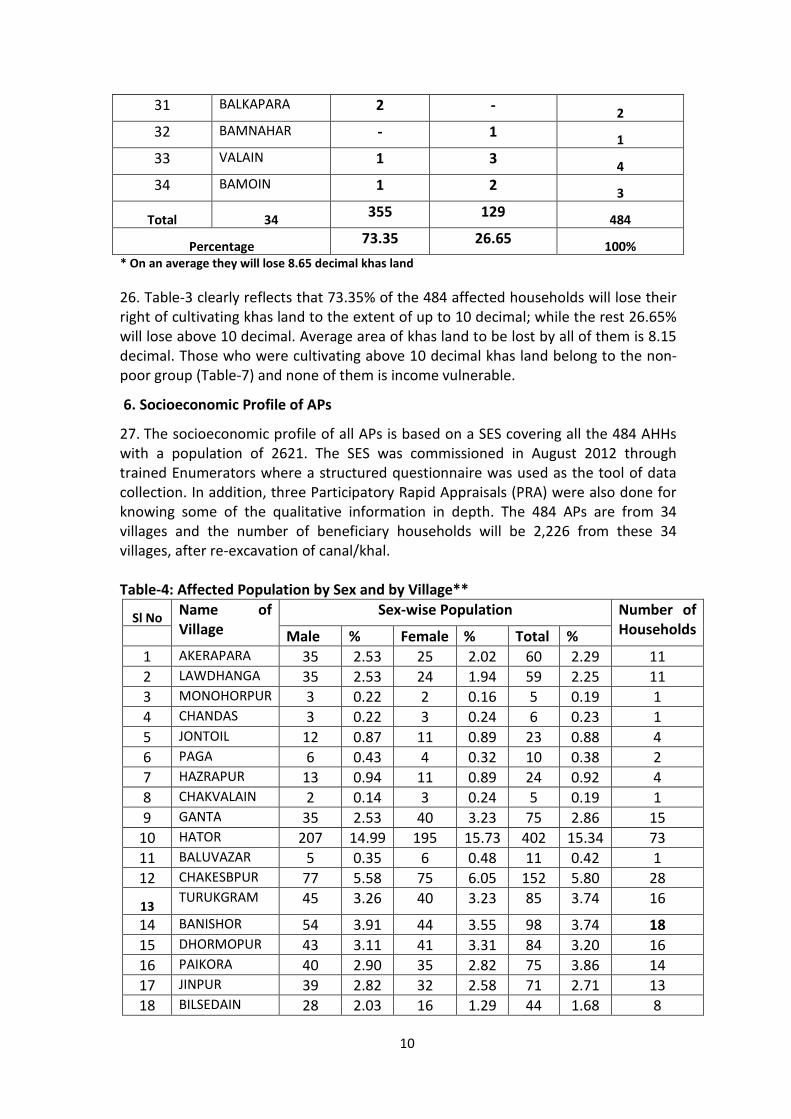
1. Subproject Objectives 16. Local people have requested for re-excavation of Santoshpara-Chatra Khal to improve the drainage congestion during pre-monsoon flood period and increase storage capacity in the khal to facilitate irrigation in the dry season. The subproject objective is to improve the pre and post monsoon farming conditions with supplementary surface water irrigation as a result of water conservation in the khal.
2. Construction Activities 17. To achieve the objective of improved flood/water management, the following physical works are proposed for the Santospara-Chatra subproject: o Re-excavation of Santoshpara-Chatra/Khal of 11.70 Km; o Benchmark Pillar 3 no; o Reference Sections 3 no; and o Construction of WMCA office.
3. Scope of Land Acquisition and Resettlement
18. The subproject will not acquire any private land; because, all the land within the khal is khas (owned by the Government) land. However, due to loss of opportunity to use the khas land, an overall estimated Four hundred Eighty four (484) households with a population of 2621 will be affected. No homestead or Commercial Business Enterprises (CBEs) will be affected by the subproject, so no relocation of residential structures or CBEs are required. There will also not be any negative impacts on Common Property Resources (CPRs) such as mosques, schools, or Union Parishad offices.
19. The affected subproject area covers thirty four (34) villages (names are in Table-2). The extent of impact varies by location. The villages are located along the sides of khal to be re-excavated. APs of all the affected villages will lose access to khas land only; they will not lose any other properties. None of them will slip down to poverty because of losing access to cultivation of khas land.
20. The proposed subproject area comprises of silted khal is surrounded by agricultural land only. The subproject area is characterized by the siltation of khal which is actually a low land area affected by early flooding during the monsoon, and sometimes by water logging.
4. Land Use and Settlement Pattern
21. At present the entire subproject affected area is being used as agriculture land. It is a rural area with the primary economy based on agriculture. The agriculture land along the khal side is one crop. The field survey could not identify any negative impacts on any CPRs, such as mosques, schools, or Union Parishad offices.
22. The current land use pattern is mixed. Major agricultural production is only one Boro paddy. However, these crops are at risk from monsoon flooding. Crops are also damaged due to drainage congestion and winter drought. There are many people involved in fisheries activities, mainly open water seasonal fishing. None would be negatively affected by the subproject; rather most of them will be benefited.

7
5. Methodology of Data Collection
23. The Implementing NGO (INGO) with the help of Project Management Office (PMO) staff, WMCA and the Union Parishad (UP) representative, carried out the DMS and stakeholder meetings with farmers, whenever necessary. The DMS showed very limited negative impact on the affected people due to the completely absence of private land acquisition in this subproject area. All the 484 APs were Included in the Socioeconomic Survey (SES). The households were interviewed through using a structured questionnaire.
Table-2: Number of Affected Households and Area of Land (Dec) by Villages**
Sl No Name of
Village
Union Affected
Households
***
Percentage Area of
Affected
Land
Average
per
Household 1 AKERAPAR
A CHANDAS 11 2.27 177.75 16.16
2 LAWDHANGA
CHANDAS 11 2.27 150.10 16.16
3 MONOHORPUR
CHANDAS 1 0.21 3.44 3.44
4 CHANDAS CHANDAS 1 0.21 24.36 24.36 5 JONTOIL
CHANDAS 4 0.83 28.64 7.16 6 PAGA
CHANDAS 2 0.41 13.75 6.88 7 HAZRAPUR
CHANDAS 4 0.83 34.44 8.61 8 CHAKVALAI
N CHANDAS 1 0.21 5.16 5.16
9 GANTA CHANDAS 15 3.10 122.87 8.19
10 HATOR Poranpur 73 15.08 534.02 7.32
11 BALUVAZAR Poranpur 1 0.21 28.65 28.65
12 CHAKESBPUR Poranpur 28 5.74 205.98 7.36
13 TURUKGRAM Poranpur 16 3.81 153.74 9.61
14 BANISHOR Poranpur 18 3.72 106.56 5.92
15 DHORMOPUR
Bhabicha 16 3.81 163.83 10.24
16 PAIKORA Bhabicha 14 2.89 108.90 7.78 17 JINPUR Bhabicha 13 2.64 130.16 10.01 18 BILSEDAIN
Bhabicha 8 1.65 28.25 3.53 19 KATHALBA
RI Bhabicha 50 10.33 365.87 7.32
20 SEDAIN Bhabicha 22 4.55 220.46 10.02

8
21 KARALIPARA Bhabicha 8 1.65 33.80 4.23
22 KOYAS Bhabicha 107 22.11 716.03 6.70
23 NAKOIN Bhabicha 2 0.41 13.38 6.69
24 CHAPRA Bhabicha 2 0.41 6.19 3.10
25 SHALALPUR Bhabicha 6 1.24 83.43 13.91
26 AMOIL Bhabicha 3 0.62 37.79 12.60
27 KALPUR Bhabicha 12 2.48 102.39 8.53
28 GABTOLI
Bhabicha 1 0.21 9.63 9.63 29 CHAKDEWL
IA Bhabicha 20 4.13 152.74 7.64
30 KORNOPUR Bhabicha 4 0.83 63.82 15.96
31 BALKAPARA Bhabicha 2 0.41 16.04 8.02
32 BAMNAHAR Bhabicha 1 0.21 22.34 22.34
33 VALAIN Valain 4 0.83 39.48 9.87
34 BAMOIN Condon
nagar
3 0.62 42.45 14.15
Total 34 5 484 100 3946.44 8.15
** Number of Affected villages is 34, while the number of beneficiary villages is 34 and their names are in para-6 & 14.
*** None of the 484 APs is disabled or will lose more than 10% of their annual income. Total population in the affected 484 households = 2621.
24. Table-2 shows the distribution of APs (Affected Persons) by village. More than 22.11% of the total 484 APs come from five union followed by 1.Chandas 10.11% 2.Poranpur 28.46% 3.Vabicha 60.38 4.Valain 0.63% &5 Chandon nagar 0.62%;. PRAs were conducted in three locations which were attended mostly by the APs. These were also attended by the WMCA members and some local elites.
25. The total khas land under cultivation is estimated at 39.46 acre (2.471 acre = one hectare) which is being cultivated by 484 Households and their losses will be compensated through giving them some money for the loss of crops. The amount of money to be given to them as compensation is estimated at Tk. 360 per decimal as is suggested by the PVAT. In other words the total amount of compensation will be; Tk. 360X3946.44(Dec)=14,20,719 (Tk. 1.42 Million). The amount of money to be received by one AP as crop compensation was within 10% of their annual income in all the cases.

9
Table-3: Distribution of 484 Affected Households in Relation to Area of Khas Land to be Lost by Them
Sl No Name of Village Number of Affected Households in Relation to Area of Land* to be Lost Up to 10 Dec
Above 10 Dec Total
1 AKERAPARA 4 7 11 2 LAWDHANGA 7 4 11 3 MONOHORPUR 1 - 1 4 CHANDAS - 1 1 5 JONTOIL 4 - 4 6 PAGA 2 - 2 7 HAZRAPUR 3 1 4 8 CHAKVALAIN 1 - 1 9 GANTA 12 3 15
10 HATOR 61 12 73 11 BALUVAZAR - 1 1 12 CHAKESBPUR 22 6 28 13 TURUKGRAM 11 5 16
14 BANISHOR 15 3 18
15 DHORMOPUR 8 8 16 16 PAIKORA 9 5 14 17 JINPUR 7 6 13 18 BILSEDAIN 7 1 8 19 KATHALBARI 38 12 50 20 SEDAIN 14 8 22 21 KARALIPARA 8 - 8 22 KOYAS 84 23 107 23 NAKOIN 2 - 2 24 CHAPRA 2 - 2 25 SHALALPUR 2 4 6 26 AMOIL 2 1 3 27 KALPUR 7 5 12
28 GABTOLI 1 - 1
29 CHAKDEWLIA 15 5 20 30 KORNOPUR 2 2 4
10
31 BALKAPARA 2 - 2 32 BAMNAHAR - 1 1 33 VALAIN 1 3 4 34 BAMOIN 1 2 3
Total 34 355 129 484
Percentage 73.35 26.65 100% * On an average they will lose 8.65 decimal khas land
26. Table-3 clearly reflects that 73.35% of the 484 affected households will lose their right of cultivating khas land to the extent of up to 10 decimal; while the rest 26.65% will lose above 10 decimal. Average area of khas land to be lost by all of them is 8.15 decimal. Those who were cultivating above 10 decimal khas land belong to the non-poor group (Table-7) and none of them is income vulnerable.
6. Socioeconomic Profile of APs
27. The socioeconomic profile of all APs is based on a SES covering all the 484 AHHs with a population of 2621. The SES was commissioned in August 2012 through trained Enumerators where a structured questionnaire was used as the tool of data collection. In addition, three Participatory Rapid Appraisals (PRA) were also done for knowing some of the qualitative information in depth. The 484 APs are from 34 villages and the number of beneficiary households will be 2,226 from these 34 villages, after re-excavation of canal/khal.
Table-4: Affected Population by Sex and by Village**
Sl No Name of Village
Sex-wise Population Number of Households Male % Female % Total %
1 AKERAPARA 35 2.53 25 2.02 60 2.29 11 2 LAWDHANGA 35 2.53 24 1.94 59 2.25 11 3 MONOHORPUR 3 0.22 2 0.16 5 0.19 1 4 CHANDAS 3 0.22 3 0.24 6 0.23 1 5 JONTOIL 12 0.87 11 0.89 23 0.88 4 6 PAGA 6 0.43 4 0.32 10 0.38 2 7 HAZRAPUR 13 0.94 11 0.89 24 0.92 4 8 CHAKVALAIN 2 0.14 3 0.24 5 0.19 1 9 GANTA 35 2.53 40 3.23 75 2.86 15
10 HATOR 207 14.99 195 15.73 402 15.34 73 11 BALUVAZAR 5 0.35 6 0.48 11 0.42 1 12 CHAKESBPUR 77 5.58 75 6.05 152 5.80 28
13 TURUKGRAM 45 3.26 40 3.23 85 3.74 16
14 BANISHOR 54 3.91 44 3.55 98 3.74 18 15 DHORMOPUR 43 3.11 41 3.31 84 3.20 16 16 PAIKORA 40 2.90 35 2.82 75 3.86 14 17 JINPUR 39 2.82 32 2.58 71 2.71 13 18 BILSEDAIN 28 2.03 16 1.29 44 1.68 8

11
19 KATHALBARI 145 10.50 125 10.08 270 10.30 50 20 SEDAIN 65 4.71 56 4.52 121 4.62 22 21 KARALIPARA 24 1.74 21 1.69 45 1.72 8 22 KOYAS 298 21.58 285 22.98 583 22.24 107 23 NAKOIN 5 0.36 6 0.48 11 0.42 2 24 CHAPRA 5 0.36 5 0.40 10 0.38 2 25 SHALALPUR 18 1.30 12 0.98 30 1.14 6 26 AMOIL 9 0.65 8 0.65 17 0.65 3
27 KALPUR 32 2.32 29 2.34 61 2.33 12
28 GABTOLI 3 0.22 2 0.16 5 0.19 1 29 CHAKDEWLIA 55 3.98 50 4.03 105 4.01 20 30 KORNOPUR 12 0.87 10 0.81 22 0.84 4 31 BALKAPARA 6 0.43 5 0.40 11 0.42 2 32 BAMNAHAR 3 0.22 2 0.16 5 0.19 1 33 VALAIN 11 0.80 10 0.81 21 0.80 4 34 BAMOIN 8 0.58 7 0.56 15 0.57 3
Total 34 1381 100 1240 100 2621 100 484 Percentage 52.69% - 47.31% - 100% -
** All of them will lose their right of cultivating khas land only. On an average they cultivate
8.15 decimal khas land.
28. Total 2621 people from 484 HHs will be affected by the subproject. None of them is title holder. They are using the silted khas land of the canal/khal which is 11.70 km in length. The sex ratio in percentage is male 52.69% and female 47.31%, which are very close to the national rural situation in this respect. The HH size is 5.42 which seems to be closer to rural national average of 5.31. Seven of the 484 affected households were headed by females.
Table-5: Identity of Heads of Female Headed Households Sl No Sl No. in
AP’s List Name of Female Heads
Name of Husbands
Name of Villages
1 69 Moss. Monoara L/ Chemon ali Kathalbari 2 166 Moss. Josna L/ Sayed ali Koyash 3 177 Moss. Jahanara L/ Jomir uddin Koyash 4 196 Moss.Guljan L/ Bolimon Hatore 5 370 Moss.Sabina L/ A.Samad Koyash 6 374 Moss.Hazera L/Gonib Koyash 7 420 Moss.Morsheda L/ Monsob ali Turgram 8 482 Mala L/ Hasan Shalalpur
29. According to the definition of vulnerable households for this project, a household will be considered as vulnerable if it goes below the poverty line due to the impact of the project. Here, none of them will go below the poverty line due to the impact of the project. They will lose a very small area of khas land only, not any other properties. They will lose only a very small portion of their income due to the loss of right to cultivating the Khas land. In contrast to it, they will be able to enhance their

12
income through irrigating their own land and this facility will be created after the re-excavation of the canal.
Table-6: Occupations of the Affected Household Heads by Village Sl No Name of
Village Number of Households by Occupations
Agriculture Business Service Housewife Others Total 1 AKERAPARA 6 3 - - 2 11 2 LAWDHANGA 7 2 1 - 1 11 3 MONOHORPUR 1 - - - - 1 4 CHANDAS 1 - - - - 1 5 JONTOIL 3 1 - - - 4 6 PAGA 2 - - - - 2 7 HAZRAPUR 3 1 - - - 4 8 CHAKVALAIN 1 - - - - 1 9 GANTA 14 1 - - - 15 10 HATOR 69 1 2 1 - 73 11 BALUVAZAR 1 - - - - 1 12 CHAKESBPUR 25 1 1 - 1 28 13 TURUKGRAM 13 1 1 1 - 16 14 BANISHOR 14 1 2 - 1 18 15 DHORMOPUR 13 2 - - 1 16 16 PAIKORA 11 1 1 - 1 14 17 JINPUR 11 1 - - 1 13 18 BILSEDAIN 6 1 - - 1 8 19 KATHALBARI 45 2 - 1 2 50 20 SEDAIN 17 1 3 - 1 22 21 KARALIPARA 6 1 - - 1 8 22 KOYAS 101 1 1 4 - 107 23 NAKOIN 2 - - - - 2 24 CHAPRA 1 1 - - - 2 25 SHALALPUR 4 1 - 1 - 6 26 AMOIL 2 1 - - - 3 27 KALPUR 10 1 1 - - 12 28 GABTOLI 1 - - - - 1 29 CHAKDEWLIA 18 1 - - 1 20 30 KORNOPUR 3 1 - - - 4 31 BALKAPARA 1 1 - - - 2 32 BAMNAHAR 1 - - - - 1 33 VALAIN 3 1 - - - 4 34 BAMOIN 2 1 - - - 3 Total 34 418 31 13 8 14 484
Parcentage 86.36 6.40 2.69 1.65 2.89 100%
30. The primary occupation is again agriculture, the traditional livelihood activity of the national rural population. More than four-fifths of the total 484 (HHs) were involved in agriculture. On the other hand, women were mostly involved in domestic
13
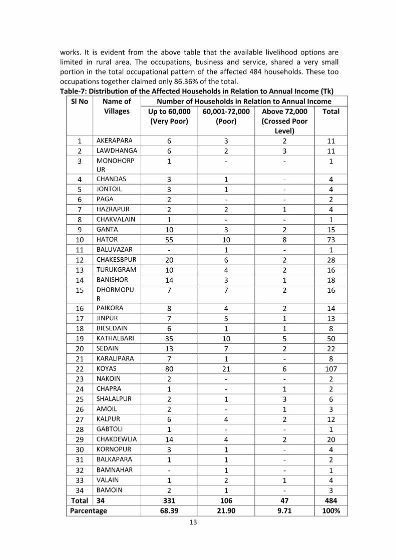
works. It is evident from the above table that the available livelihood options are limited in rural area. The occupations, business and service, shared a very small portion in the total occupational pattern of the affected 484 households. These too occupations together claimed only 86.36% of the total. Table-7: Distribution of the Affected Households in Relation to Annual Income (Tk)
Sl No Name of Villages
Number of Households in Relation to Annual Income Up to 60,000 (Very Poor)
60,001-72,000 (Poor)
Above 72,000 (Crossed Poor
Level)
Total
1 AKERAPARA 6 3 2 11 2 LAWDHANGA 6 2 3 11 3 MONOHORP
UR
1 - - 1
4 CHANDAS 3 1 - 4 5 JONTOIL 3 1 - 4 6 PAGA 2 - - 2 7 HAZRAPUR 2 2 1 4 8 CHAKVALAIN 1 - - 1 9 GANTA 10 3 2 15
10 HATOR 55 10 8 73 11 BALUVAZAR - 1 - 1 12 CHAKESBPUR 20 6 2 28 13 TURUKGRAM 10 4 2 16 14 BANISHOR 14 3 1 18 15 DHORMOPU
R 7 7 2 16
16 PAIKORA 8 4 2 14 17 JINPUR 7 5 1 13 18 BILSEDAIN 6 1 1 8 19 KATHALBARI 35 10 5 50 20 SEDAIN 13 7 2 22 21 KARALIPARA 7 1 - 8 22 KOYAS 80 21 6 107 23 NAKOIN 2 - - 2 24 CHAPRA 1 - 1 2 25 SHALALPUR 2 1 3 6 26 AMOIL 2 - 1 3 27 KALPUR 6 4 2 12 28 GABTOLI 1 - - 1 29 CHAKDEWLIA 14 4 2 20 30 KORNOPUR 3 1 - 4 31 BALKAPARA 1 1 - 2 32 BAMNAHAR - 1 - 1 33 VALAIN 1 2 1 4 34 BAMOIN 2 1 - 3
Total 34 331 106 47 484 Parcentage 68.39 21.90 9.71 100%

14
31. None of them will lose more than 10% of the annual income for the loss of right to cultivation of khas land. So, none of them will become poor as the impact of the project. Moreover, through the utilization of irrigation facility to be created after the re-excavation of canal, almost all of them will be able to increase their agricultural production which will result into increment of their income.
Table-8: Membership of the Affected Households’ Family Members in NGOs Sl No Name of
Villages Number of Members in Relation to NGOs*
ASA BRAC GB Other NGOs
WMCA Non Member
Total
1 AKERAPARA 3 2 2 1 - 3 11 2 LAWDHANGA 2 2 3 2 - 2 11 3 MONOHORPUR - 1 - - - - 1 4 CHANDAS - - 1 - - - 1 5 JONTOIL 1 1 1 - - 1 4 6 PAGA - 1 1 - - 2 7 HAZRAPUR 1 2 1 - - - 4 8 CHAKVALAIN 1 - - - - - 1 9 GANTA 3 3 4 3 - 2 15
10 HATOR 22 25 25 1 - - 73 11 BALUVAZAR - - - 1 - - 1 12 CHAKESBPUR 11 6 5 4 - 2 28 13 TURUKGRAM 5 8 3 - - - 16 14 BANISHOR 10 4 2 1 - 1 18 15 DHORMOPUR 5 6 2 2 - 1 16 16 PAIKORA 2 7 1 1 - 3 14 17 JINPUR 5 3 2 2 - 1 13 18 BILSEDAIN 2 2 1 - 3 - 8 19 KATHALBARI 20 18 2 3 7 - 50 20 SEDAIN 6 4 1 5 5 1 22 21 KARALIPARA 2 2 - 2 1 1 8 22 KOYAS 20 30 12 8 30 7 107 23 NAKOIN - 1 - 1 - - 2 24 CHAPRA 1 - 1 - - - 2 25 SHALALPUR 1 2 - 1 1 1 6 26 AMOIL 2 1 - - - - 3 27 KALPUR 3 2 1 - 4 2 12 28 GABTOLI 1 - - - - - 1 29 CHAKDEWLIA 7 4 - 2 5 2 20 30 KORNOPUR 2 2 - - - - 4 31 BALKAPARA 1 - 1 - - - 2 32 BAMNAHAR - - - - - 1 1 33 VALAIN 2 2 - - - - 4 34 BAMOIN - 2 - - - 1 3
Total 34 135 141 74 41 56 31 484 Percentage 27.89% 29.13% 15.29% 8.47% 11.59% 6.40% 100%
* Some of them are members of more than one NGO’s.

15
32. Table-8; clearly reflect that, for the reasons unknown, NGO coverage among the affected 484 households is minimum, only 30.39% of the households, despite the fact that 91.09% of the households are either poor or very poor (Table-6). So, there are enough scope for integrating the affected households either with a NGO or with the WMCA and the initiative in this respect should be taken by the project.
Table-9: Number of Affected Households in Relation to Latrine in Home Sl No Name of
Villages Number of Households in Relation to Latrine
Pacca Semi Pacca
No Latrine Total
1 AKERAPARA 7 3 1 11 2 LAWDHANGA 6 3 2 11 3 MONOHORPUR 1 - - 1 4 CHANDAS 1 - - 1 5 JONTOIL 2 1 1 4 6 PAGA 1 - 1 2 7 HAZRAPUR 1 2 1 4 8 CHAKVALAIN - 1 - 1 9 GANTA 7 6 3 15
10 HATOR 20 40 13 73 11 BALUVAZAR - 1 - 1 12 CHAKESBPUR 5 10 13 28 13 TURUKGRAM 6 4 6 16 14 BANISHOR 7 5 6 18 15 DHORMOPUR 6 4 6 16 16 PAIKORA 4 4 6 14 17 JINPUR 3 5 5 13 18 BILSEDAIN 4 2 2 8 19 KATHALBARI 15 10 25 50 20 SEDAIN 7 5 10 22 21 KARALIPARA 3 2 3 8 22 KOYAS 18 28 61 107 23 NAKOIN - 1 1 2 24 CHAPRA 1 1 - 2 25 SHALALPUR 2 3 1 6 26 AMOIL - 2 1 3 27 KALPUR 4 5 3 12 28 GABTOLI - 1 - 1 29 CHAKDEWLIA 5 7 8 20 30 KORNOPUR 3 2 3 4 31 BALKAPARA - 1 - 2 32 BAMNAHAR - 1 1 1 33 VALAIN 1 2 1 4 34 BAMOIN 1 1 1 3
Total 34 135 163 185 484 Percentage 27.89% 33.68% 38.22% 100%

16
33. Nearly three-fourths of the affected 484 households do not have any kind of latrine, which is the clear reflection of poverty among the affected households. Again, from here it may be said also that some social development activities should also be undertaken in the affected area as the concomitant of poverty reduction activities. 34. It has been mentioned in Table-2 that the 484 affected households will lose their right to cultivating 39.46 acre silted khas land when the canal/khal will be re-excavated. It has been assumed (as assessed by the PVAT) that one decimal land produces about 24 kg of paddy and its value is 24 kgXTK.15 per kg = TK. 360. In terms of money each of them will be given the crop compensation at the rate of Tk. 360 per decimal as has been estimated by the PVAT. On the basis of this compensation rate, the amounts of compensation are calculated for each of the 484 affected persons and the table below provides the distribution of the affected persons in relation to the amounts of losses to be incurred by them. Table-10: Number of Affected Households in Relation to the Amount of Money to be Lost Due to Losing Access to Khas Land
Sl No Name of Villages
Number of Households in Relation to Amount of Loss
Up to-2000
2001-3000
3001-4000
4001-5000
Above 5000
Total
1 AKERAPARA 5 1 1 1 3 11 2 LAWDHANGA 2 5 - 2 2 11 3 MONOHORPUR 1 - - - - 1 4 CHANDAS - - - - 1 1 5 JONTOIL - 4 - - - 4 6 PAGA 1 - 1 - - 2 7 HAZRAPUR 1 1 1 1 - 4 8 CHAKVALAIN 1 - - - - 1 9 GANTA 7 4 2 - 2 15 10 HATOR 38 14 10 5 6 73 11 BALUVAZAR - - - - 1 1 12 CHAKESBPUR 14 5 4 2 3 28 13 TURUKGRAM 5 5 2 - 4 16 14 BANISHOR 13 2 1 - 2 18 15 DHORMOPUR 4 3 3 2 4 16 16 PAIKORA 4 4 2 3 1 14 17 JINPUR 4 3 2 2 2 13 18 BILSEDAIN 6 1 1 - - 8 19 KATHALBARI 15 20 5 5 5 50 20 SEDAIN 8 3 5 3 3 22 21 KARALIPARA 5 1 1 - 1 8 22 KOYAS 54 23 8 10 12 107 23 NAKOIN - 2 - - - 2 24 CHAPRA 2 - - - - 2 25 SHALALPUR - 1 1 2 2 6 26 AMOIL 1 1 - - 1 3

17
27 KALPUR 3 3 3 2 1 12 28 GABTOLI - - 1 - - 1 29 CHAKDEWLIA 10 5 1 - 4 20 30 KORNOPUR 1 - 1 - 2 4 31 BALKAPARA - 2 - - - 2 32 BAMNAHAR - - - - 1 1 33 VALAIN 2 - - 2 - 4 34 BAMOIN 1 - - - 2 3 Total 34 208 113 56 42 65 484
Percentage 42.98% 23.35% 11.57% 8.68% 13.43% 100%
35. From Table-2 it can be computed that the average amount of loss per affected household is around Tk. 3500. Considering this amount as the medium nearly 46% of the affected households fall in this medium group of losses (Tk. 3001-4000). The table shows that the amount of loss will be within Tk. 3000 for about one-third of the total 484 households. Again, none of the 484 APs will lose more than 10% of their annual income due to the loss of cultivation right to khas land. Instead, their income will be increased due to re-excavation of the canal/khal which will create irrigation facility during the Boro season.
36. The subproject has a very significant impact on the livelihood of the AHHs. According to the local people they will get more benefit from the subproject compared to their losses. Almost all of the 484 AHHs cultivating khas land within the khal are landless or marginal farmers. Special attention needs to be given to all the AHHs who will become vulnerable due to implementation of the subproject. Livelihood enhancement will be provided through employment and income generating activities for vulnerable AHHs. The related sub-components shown below, and the activities of employment and income generation, will be undertaken by the WMCA.
° Sub-component: (a) Community-based routine maintenance of the canal and other water management facilities. The activities under this are: (i) organizing canal maintenance groups; (ii) skills training and capacity building; (iii) delivery of basic tools and equipment; and (iv) engaging APs as works in the subproject.
° Sub-component: (b) Social forestry, site plantation, and nursery development. The activities are: (i) organizing Community Forestry Groups (CFGs); (ii) skills training of CFGs; (iii) tree plantation for canals; and (iv) seeds and saplings for establishing nurseries.
° Sub-component: (c) Income generation using existing water resources by implementing activities, such as, (i) strengthening self-help groups (SHGs); (ii) skills training and capacity building of groups; and (iii) initial supplies of inputs needed for materializing the training into actions.
37. The number of indirectly AHHs is nil. Agricultural lands are mainly cultivated by the farmers with the help of some hired laborers only when required and these laborers also work in other fields in the locality. So there is little chance for them to remain jobless.

18
38. The majority of the APs who participated in the group discussions and stakeholders meetings have expressed their high expectation for social and economic benefits from the subproject. Local administration and people’s representatives such as Chairman and members of the UPs have assured the Project authority that they will extend cooperation. They also expected that fishing (open water and cultured) opportunities will be enhanced, which will help in improving their socioeconomic conditions.
39. In general, the community responded positively to the subproject. However, some concerns were raised and most of these are related to proper and timely compensation payments for their lost assets and income. Their concerns were over delays in compensation payment and apprehension of harassment in receiving compensation payment from the Government. • During meetings the participants indicated that the implementation of the subproject will be beneficial to all the people of the locality. However, according to the subproject feasibility study and present survey, there is no land to be acquired in which case Government payment must not be a big issue. During group discussions participants desired help and assistance from the Project to simplify the compensation payments procedure.
• For security reasons and for ease of payments to APs, temporary camps may be set up in the vicinity of the affected areas.
• People losing livelihood from the cultivated khas land in khal are very much concerned and skeptical about their compensation as they do not have right to the land but have been using it for generation.
C. LAND ACQUISITION AND RESETTLEMENT POLICY FRAMEWORK AND ENTITLEMENTS
1. Land Acquisition and Resettlement Principles
40. Land acquisition and resettlement of the APs, and providing special assistance to vulnerable and indirectly affected APs in re-establishing their livelihood and income have been conducted in accordance with the GoB’s Acquisition and Requisition of Immovable Properties Act of 1982 and amendment in 1993. The Draft National Policy on Resettlement and Rehabilitation (NPRR); and the Asian Development Bank’s (ADB’s) Policy on Involuntary Resettlement (1995)7 as well as by following ‘best practices’ followed in Bangladesh (i) avoiding involuntary resettlement where feasible, (ii) minimizing displacement by considering all alternatives where population displacement is unavoidable, and (iii) ensuring that displaced people receive assistance so that they would be at least as well off as they would have been in the absence of the project. The following are major elements of the policies/practices are expected to be adopted by the Project:
(i) Involuntary resettlement and loss of livelihood will be avoided where
feasible; (ii) Where population displacement is unavoidable, it will be minimized by
exploring all viable project options;

19
(iii) People unavoidably displaced will be compensated and assisted, so that their economic and social future will be generally as favorable as it would have been without the Project;
(iv) Vulnerable APs will be provided with resettlement facilities or support to resettle in proximity to their social groups and good communication network with employment opportunities;
(v) People affected will be informed fully and consulted on resettlement and compensation options;
(vi) Gender equity will be maintained in resettlement planning and implementation;
(vii) Existing social and cultural institutions of resettlers and their hosts will be supported and used to the greatest extent possible, and resettlers will be integrated economically and socially into host communities;
(viii) The absence of a formal title to land by some effected groups will not be a bar for compensation, particular attention should be paid to households headed by women and other vulnerable groups, such as indigenous people and ethnic minorities, elderly and disable persons and appropriate assistance provided to help them improve their status;
(ix) As far as possible involuntary resettlement will be conceived and executed as part of the Project;
(x) People who will be affected indirectly will be facilitated to regain their livelihood and socio-economic status;
(xi) Participation of the local community will be ensured through incorporating them in different committees involved in planning through implementation process of RP; and
(xii) The full cost of resettlement will be included in the presentation of Project costs and benefits
41. The subproject resettlement activities will be carried out in consultation with the APs, and all efforts will be made to minimize disruption during the Project implementation. A Detailed Measurement Survey (DMS), including a full census will be conducted once the detailed design has been approved. The date of census will be the cut-off date for resettlement benefits; and any encroachers/informal settlers after that date will not be entitled to resettlement benefits. For land title-holders, notification under Section 3 by the DC under the LAA will constitute the cut-off date. 2. The Entitlement Matrix
42. An entitlement matrix has been prepared on the basis of currently known impacts that none of the 204 APs will become vulnerable due to the impact of the project. It identifies the categories of impact based on surveys carried out in the subproject area and shows the entitlements for each type of loss. The entitlement matrix will also incorporate potential impacts which will be confirmed by the DMS (census and SES) after finalization and approval of the DD. If new impacts are identified later during preparation of final RP, based on the DMS, then losses will be included in the entitlement matrix and the final RP will be revised accordingly.

20
Table 11: Entitlement Matrix and Responsible Implementation Agencies
Sl#
Nature of Loss Definition of Entitled Person
(EP)
Entitlements Relevant Policy Legal Section
Implementation Issues Implementation Responsibility
1 Loss of Land (Agricultural, Commercial, Homestead, Pond, Gher (Shrimp Ponds) Boroj (Betel Leaf Production Land)
Legal owner of the land at the time of serving notice under Section 3 of LA Laws
Replacement land or CCL (Market value assessed by DC plus premium as per Law) Additional grant to cover Maximum Allowable Replacement Value (MARV) of land. Stump duty to facilitate land purchase; Compensation for standing crops assessed by DC/PVAT; Land development cost for homestead and commercial land losers (if applicable) assessed by PVAT
The Acquisition and Requisition of Immovable Property Ordinance, 1982 (Ordinance No. II of 1982) & amendment by Ordinance VII of 1993
a. Assessment of quantity and quality of land
b. Assessment of Market Value
c. Assessment of MARV by Land Market Survey (LMS)
d. Title updating e. Payment of CCL f. APs will be fully informed
of the entitlements and procedures regarding payment
g. Additional cash grant to cover the replacement value of land h. Stamp duty will be due to an EP in case of land purchase within one year of receiving CCL from DCs
h. Stamp duty will be due to an EP in case of land purchase within one year of receiving CCL from DCs
i. Compensation for standing crops
a. DC, LGED b. DC, LGED c. EA/WMCA/UP d. DC e. DC f. EA/WMCA/UP, LGED g. EA, CRO h. LGED-CRO/EA i. DC/LGED

21
Sl#
Nature of Loss Definition of Entitled Person (EP)
Entitlements Relevant Policy Legal Section
Implementation Issues
Implementation Responsibility
2 Loss of Under Water Land (Char land)
Legal owners(s) of land (DCs in case of khas land after legally established AD8 line), the previous private owners of Khas land identified at the time of eroding the land into river/Khal below the AD line as per land rent record
i. As 1 if DC cannot declare the land khas,
ii. Case of Khas – cash compensation under CCL to respective DCs without 50% Premium
iii. Value of eroded Khas land assessed by PVAT-to the previous owners whose land was recorded
The Acquisition and Requisition of Immovable Property Ordinance, 1982 (Ordinance Bo. II of 1982) & amendment by Ordinance VIII of 1993
a. Assessment of quantity and quality of land
b. Assessment of Market Value
c. Assessment of MARV by LMS
d. Title Updating e. Payment of CCL f. APs will be fully
informed of the entitlements and procedures regarding payment
g. Additional cash grant to cover the Replacement Value of land.
h. Stamp duty will be due to an EP in case of land purchase within one year of receiving CCL from DCs
a. DC, LGED b. DC, LGED c. EA/WMCA/UP d. DC e. DC f. EA/WMCA/UP,LGED- CRO g. LGED-CRO/EA h. LGED-CRO/EA

22
Sl#
Nature of Loss
Definition of Entitled Person (EP)
Entitlements Relevant Policy Legal Section
Implementation Issues Implementation Responsibility
3 Loss of Homestead/Commercial and Other structure by Owners
Legal owner of the land at the time of serving LA notice Section 3 as recorded in the LA award Book
i. CCL (Market value plus 50% premium as per Law)
ii. Additional grant to cover market value of the structure
iii.Transfer grant(TG) @ 12.5% of the value of non-masonry (kutcha) and semi-pucca and 5% for masonry (pucca) structure assessed by PVAT
iv.Owner will be allowed to take all salvageable materials (free of cost) without delaying the project work
v.Re-construction grant(CG) @ 12.5% of the value of all structures assessed by the PVAT for titled owners
vi.Special assistance for Female Headed/Vulnerable Households @ TK 2000, TK 3000 and TK 5000 for kutcha, semi pucca and pucca structure
vii.Land/Homestead Development Grant assessed by PVAT
viii. Special Assistance of TK 5000/= for Vulnerable Households having disabled member in the family
The Acquisition and Requisition of Immovable Property Ordinance, 1982 (Ordinance Bo. II of 1982) & amendment by Ordinance VIII of 1993
a. Assessment of no. and quality of structure
b. Assessment of market value c. Assessment of MARV by LMS d. Title updating e. Payment of CCL, plus 50%
premium f. APs will be fully informed of
the entitlements and procedures for getting those
g. Additional grant to cover the MARV of the structure land
h. Allowed to take away the salvageable
i. Transfer grant @ 12.5% of the assessed value of the structure
j. Construction Grants @ 12.5% of the assessed value of the structure
k. Special Assistance to Female Headed Households by category o the structure
l. Homestead loser will be eligible to get Homestead Development and Reconstruction Grant
m. Special assistance to Vulnerable Households with disabled family member
a. DC, LGED b. DC, LGED
c. IA/WMCA/UP
d. DC
e. EA/WMCA/UP,
LGED CRO
f. LGED CRO/EA g. LGED CRO/EA h. LGED CRO/EA i. LGED CRO/EA j. LGED CRO/EA k. LGED CRO/EA l. LGED CRO/EA m. LGED CRO/EA n. LGED CRO/EA o. LGED CRO/EA

23
Sl#
Nature of Loss Definition of Entitled Person
(EP)
Entitlements Relevant Policy Legal Section
Implementation Issues
Implementation Responsibility
4 Loss of Access to Cultivate Land By Farmers, Tenant/Sharecroppers including cultivators of Khas land
Farmers, tenants and sharecroppers of the land under contract as identified by the SES to be conducted during implementation of RP
i. Transition Allowance equivalent to one year’s net income from the cultivable land to farmer, tenant/sharecropper, based on Market Value of the crops/fish
The Acquisition and Requisition of Immovable Property Ordinance, 1982 (Ordinance Bo. II of 1982) & amendment in 1993
a. Individuals identified by the census/SES as Farmer, tenant or sharecropper of land
b. Cash grant as determined by assessment will be paid after taking possession of the land
c. The legal owner certifies the tenancy
d.SES will identify the farmer(cultivator of khas land), tenant/share
a. EA/WMCA/UP, LGED
b. LGED CRO/EA
c. LGED
d. LGED
24
Sl#
Nature of Loss Definition of Entitled Person
(EP)
Entitlements Relevant Policy Legal Section
Implementation Issues
Implementation Responsibility
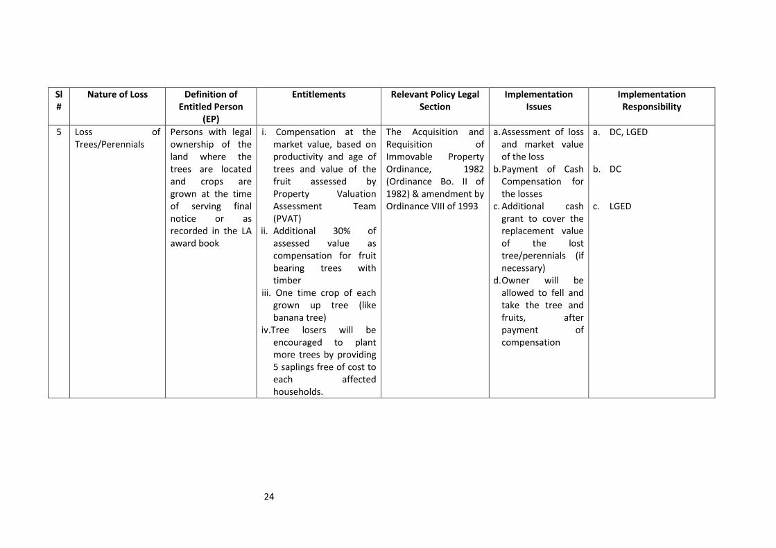
5 Loss of Trees/Perennials
Persons with legal ownership of the land where the trees are located and crops are grown at the time of serving final notice or as recorded in the LA award book
i. Compensation at the market value, based on productivity and age of trees and value of the fruit assessed by Property Valuation Assessment Team (PVAT)
ii. Additional 30% of assessed value as compensation for fruit bearing trees with timber
iii. One time crop of each grown up tree (like banana tree)
iv.Tree losers will be encouraged to plant more trees by providing 5 saplings free of cost to each affected households.
The Acquisition and Requisition of Immovable Property Ordinance, 1982 (Ordinance Bo. II of 1982) & amendment by Ordinance VIII of 1993
a. Assessment of loss and market value of the loss
b. Payment of Cash Compensation for the losses
c. Additional cash grant to cover the replacement value of the lost tree/perennials (if necessary)
d. Owner will be allowed to fell and take the tree and fruits, after payment of compensation
a. DC, LGED b. DC c. LGED

25
Sl#
Nature of Loss Definition of Entitled Person
(EP)
Entitlements Relevant Policy Legal
Section
Implementation Issues Implementation Responsibility
6 Loss of Residence/Commercial Structures by Owner or Squatters
Owner of the structure identified by SES
i. Cash compensation for the structure at market value
ii. Transfer grant (TG) @ 12.5% of the value of kutcha and semi-pucca and 5% for pucca structure assessed by PVAT
iii. Owner will be allowed to take all salvageable materials (free of cost without delaying the project work
iv.Re-construction grant (CG) @ 12.5% of the value of all structures assessed by the PVAT for titled owners
Measures in RP as per ADB guidelines
a. Payment of structure cost b. Verification of SES and other
records c. APs will be fully informed
about their entitlement and assisted in obtaining it
d. A Transfer Grant to each household will be paid before/during vacating the project sites
e. Removal cost for commercial structure at the same rate to the owners of structures
f. Reconstruction Grant for each structure (household/commercial) will be paid before/during vacating the Project site
g. Special assistance to Female Headed/vulnerable Household
a. LGED-CRO/IADC b. LGED
c. LGED
d. LGED-CRO/EA
e. LGED-CRO/EA f. LGED-CRO/EA g. LGED-CRO/EA

26
Sl#
Nature of Loss Definition of Entitled Person
(EP)
Entitlements Relevant Policy Legal Section
Implementation Issues Implementation Responsibility
7 Loss of access to house/commercial structure (rented or lease)
Tenants renting/leasing the property as identified by the socio-economic survey
i. One-time cash grant for facilitating alternative housing/structure assessed by PVAT
Measures in RP as per ADB guidelines
a. Verification of SES Records and other Records
b. A shifting Allowance per unit will be paid before relocation from project sites
a. LGED b. LGED-CRO
8 Losses of residence by informal settlers/encroachers or unauthorized occupants
Heads of Households occupying homestead land illegally or squatting on RoW as identified by SES
i. Cash compensation for the structure at market value
ii. Transfer grant (TG) @ 12.5% of the value of kutcha and semi-pucca and 5% for pucca structure assessed by PVAT
iii. Owner will be allowed to take all salvageable materials (free of cost without delaying the project work
iv Re-construction grant (CG) @ 12.5% of the value of all structures assessed by the PVAT for titled owners
Measures in RP as per ADB guidelines
a. CCL for structures if recognized by DCs
b. Verification of SES data and the Award Book
c. Compensation for loss of structure (as mentioned in Sl No. 6)
d. Transfer or shifting cost per household (as mentioned in Sl NO.6)
a. DC b. LGED c. LGED-CRO d. LGED-CRO/EA

27
Sl#
Nature of Loss Definition of Entitled Person
(EP)
Entitlements Relevant Policy Legal Section
Implementation Issues Implementation Responsibility
9 Loss of Business by shops/business owners due to dislocation
Owner/Operator of the business as recorded by the Socio-economic Survey
i. Business Restoration Grant to owners, renters and leaseholders assessed by PVAT (not less than 6 months net income)
ii. Non titled shop owners above the poverty line will not be eligible for business restoration grant
Measures in RP as per ADB guidelines
a. All persons recorded by the SES
b. Cash grant to be paid before leaving the project land
a. LGED b. LGED-CRO/EA
10 Loss of income, Employment/Work Opportunity of Full time/part time Workers
Workers of affected business as recorded in the SES
i. One time cash grant for 90 days at the rate of local wage rate
Measures in RP as per ADB guidelines
a. All persons recorded by the SES
b. Cash grant to be paid before taking possession of land
c. Involvement of the EP in Project civil works
a. EA/LGED-CRO
b. LGED-CRO/EA
c. EA/LGED-CRO

28
Sl#
Nature of Loss Definition of Entitled Person
(EP)
Entitlements Relevant Policy Legal Section
Implementation Issues Implementation Responsibility
11 Loss of access to utility services such as piped Water supply, Gas, Electricity, Sewerage line or Telephone
Legal owner of the structure with utility services at the time of serving LA notice section 3 as recorded in the LA Award Book. Or only the legal owner of the utility service as identified by SES
i. Cash compensation for the utility facilities at Market value
ii. One time cash grant to transfer/re-installment the utility service to new location
The Acquisition and Requisition of Immovable property Ordinance, 1982 (Ordinance Bo. II of 1982) & amendment by Ordinance VIII of 1993
a. Payment of CCL for the losses
b. Verification of SES and other records
c. APs will be fully informed about their entitlement and assisted in obtaining it
d. A transfer/re-installment grant for identified utilities to each household/structure owner (renter) will be paid during or after vacating the project sites
a. DC b. EA/LGED
c. EA/LGED
d. LGED-CRO

29
Sl#
Nature of Loss Definition of Entitled Person
(EP)
Entitlements Relevant Policy Legal Section
Implementation Issues Implementation Responsibility
12 Loss of community facilities/common property resources by APs
Community as a whole where the APs will relocate
i. CCL for structure ii. Transfer Grant iii. Reconstruction/Improveme
nt of the community, facilities/common property resources
The Acquisition and Requisition of Immovable property Ordinance, 1982 (Ordinance Bo. II of 1982) & amendment by Ordinance VIII of 1993
a. CCL
b. Cash grant for transfer/reconstruction of structure
a. DC b. LGED-CRO/IA
13 Adverse impact on the host communities due to relocation of APs during and after project implementation
Affected or host area/village where the APs will relocate
i. Provision for additional civic amenities (roads, tube-well for drinking water, community slab latrines, to community facilities)
N/A a. Assessment of community needsb. Consult the host
population and provision for common property resources
c. Implement the mitigation programs
a. LGED b. LGED c. LGED-CRO/EA

30
D. CONSULTATION AND DISCLOSURE
1. Consultation and Stakeholders’ Participation
43. Consultation and communication with APs and other stakeholders during the preparation stage of the subprojects will be an integral part of gathering relevant data for impact assessment. Moreover, Sharing of knowledge and experiences help the development of appropriate options for resettlement of APs. The RP will be disclosed to the affected community in Bengali in FGDs to obtain the views of APs and other stakeholders on the compensation and resettlement provisions as per Government laws and ADB guidelines. As appropriate, the contribution of APs and beneficiary groups will be included in the subproject’s RP.
2. Grievance Redress Mechanism
44. The Ministry of Local Government, Rural Development and Cooperatives (MoLGRDC) through a gazette notification formed two committees namely Property Valuation Advisory Team (PVAT) and Grievance Redress Committee (GRC) vide No 40.068.004.00.00.002.2011-161 dated 10-03-2011 for implementation of the Project’s subproject RP. The GRC was formed for resolving any grievances involving resettlement benefits, relocation and other assistance. The scope and responsibility of the Grievance Redress Committee has been clearly defined in the gazette.
45. The GRC consists of one local Representative from LGED who will chair the GRC. Members will include AP representatives, including one male and one female; representatives of the UP; and one member from the INGO, who will act as member secretary. The GRC will be formed immediately after LAP/RP is approved; and the PIC, Social Safeguard Specialist or INGO Area Manager will facilitate and coordinate the GRC activities.
46. The GRC will have the power to resolve resettlement and compensation issues preemptive to their being addressed through the legal system. The functions of the GRC will be to:
1. Receive application of APs grievance within one month of the receipt of ID card or from when APs are informed of their entitlements.
2. Hold open hearings in the office of the Chairperson and resolve the grievance within 15 days of receiving complaints from APs.
3. Inform aggrieved persons about GRC meetings and give them an opportunity to place their grievance before the GRC.
4. Keep meeting minutes and records of grievances. 5. Refer the APs grievances to the DC or the concerned legal authority, if the
grievance relates to land acquisition or conventional law. 6. Make decisions to resolve APs grievances following RP policy, if outside
conventional law and the grievance does not lend itself to arbitration. 7. Amicably resolve issues quickly without resorting to expensive, time
consuming legal actions. 8. Ensure participation of concerned local people and be an advocate for the
interests of vulnerable APs.

31
47. Prior to using the GRC, all efforts will be made at the Subproject level to reach informal resolution of AP grievances. Only then will the GRC be approached by APs having grievances. Grievance cases from the APs will be received in the office of the GRC Chairperson. Upon receipt of complaints, the GRC will organize hearings and pass verdicts, which will be formally conveyed to the concerned APs. The GRC will settle the disputes within 15 days of receiving the complaint from APs. If the complaint is not resolved at GRC level, the matter may be referred to the court.
E. COMPENSATION AND RESETTLEMENT BUDGET AND FINANCING
48. This subproject does not need any budget for land acquisition as all the land is khas land (owned by the Government) and in this project this is being cultivated by 484 persons. As per RF, bearing of the full costs of compensation will be the responsibility of LGED and they will pay only for the compensation of crops at the rate of TK. 360 per decimal as determined by the PVAT. In this process, the total amount of crop compensation is 39.46 acre= 3946.44 decimal X TK. 360=TK. 14,20,719. It is to be noted that the entire compensation amount is outside the CCL and to be given/paid by LGED through the INGO with the help of DC office, whenever needed.
Table 12: Budget for Compensation and Special Assistance to APs
No. Description Number of APs
Rate (TK) Amount (TK)
A Compensation for Loss of crops only. The entire project area is on khas land which is being cultivated by 484 persons. All of them will get only crop compensation
484 As per PVAT Rate = Tk. 360 per decimal
14,20,719
B Preparation of EP/EC file & payment statement (Tk. 150 per AP), and cost of meetings, stationery, food & other miscellaneous cost for LGED officials during disbursement of compensation (Tk. 50 per AP): total Tk. 200 per AP.
96,800
C Total ………….......
…………....... 15,17,519
· As per PVAT, production of one decimal land = 24 kg paddy, value per kg = Tk. 15, value of 24 kg = 24 kg X Tk. 15 = Tk. 360. In the entire affected land only one crop is grown in a year.
49. The cost of cash compensation will be provided by the Project. The benefits will be paid directly to eligible persons (EPs) by LGED. The rehabilitation and training for APs will be provided through WMCA for skills and livelihood support including agriculture and fisheries and livestock related activities. The training program will be based on the vulnerability and need assessment carried out through the census, SES and consultation exercise.

32
F. RESETTLEMENT ACTION PLAN IMPLEMENTATION SCHEDULE
1. Implementation Schedule
50. The Project’s institutional strengthening and capacity building activities will commence in the first year of the Project; these activities will be gradually tapered off towards Project completion. Subproject Implementation will be conducted following a rolling program over the 7 year life of the Project. RPs will be implemented before the award of civil award contracts. However, the Implementation schedule for subprojects will be prepared considering the possible changes from the Detailed Design and DMS. Time schedule for RP Implementation for this subproject is presented in Table-13.
Table-13: RAP Implementation Schedule of Santoshpara-Chatra Subproject
Activities Months 1 2 3 4 5 6 7 8 9 10 11 12
Request for Formation of Committees
×
Formation of PVAT/GRC x Draft DD Completed x x x PMO Consulting WMCA/APs/Beneficiaries on DD
x x X
Finalizing DD X × DMS Census/SES (DMS) Done by PMO/WMCA
X ×
PMO/WMCA Census/SES (DMS) Analysis by PIC
x ×
PMO/WMCA Video Filming of ROW
×
Overlay DD & Mauza Maps
×××
Hiring INGO X INGO Reviews/Certifies PMO Census/SES/Video
X x x x
Prepare RP x x ADB Clearance of Revised RP
x
Disclosure of Revised RP with WMCA/APs/Beneficiaries
x
Compensation payment x x x x And on ward

33
2. Monitoring and Evaluation
51. LGED, through the ESS, will establish a monitoring system involving the Chief Resettlement Officer (CRO), District and Upazila officers of LGED and the PIC for collecting, analyzing and preparing Quarterly Progress Reports on the progress of RP implementation. LGED will also provide an Annual Report to ADB, the Project Funding Agency (PFA).
52. The RP monitoring will be conducted to provide feedback to LGED and to assess implementation effectiveness. A Mid-term Review of the monitoring and evaluation reports and other relevant data will identify the actions needed to improve the resettlement performance. Evaluation of RP implementation will assess whether the resettlement objectives were appropriate and whether they were met, specifically, whether livelihoods and living standards were restored or enhanced. The evaluation will also assess resettlement efficiency, effectiveness, impact and sustainability, drawing upon lessons learned as a guide to future resettlement planning.
a. Internal Monitoring
53. Internal monitoring will be carried out by the ESS with support from the CRO, field staff at LGED District and Upazila offices; and the PIC Resettlement Specialist will establish a monthly monitoring system and prepare a monthly Progress Report on all aspects of RP implementation. The initial census and SES of this RP will provide the benchmark data; and periodic surveys will be carried out to measure changes against this baseline data. Assisted by District and Upazila Engineers, and PIC Resettlement Specialist, the Project Director (PD) will monitor land acquisition and resettlement. The existing LGED Management Information system (MIS) can be updated accordingly to incorporate the necessary data and Environment and Safeguard Section (ESS) of IWRMU will tabulate quantitative information obtained through monitoring.
54. The Social Safeguard Specialist with the PIC team will be supervising and monitoring the RP implementation for LGED. The PIC will sub-contract an external independent monitoring and evaluation agency to an experienced person/firm or institution (External Monitor) that has sufficient experience and understanding of resettlement. The tasks of the external monitor will be to: (i) verify results of internal monitoring (ii) assess whether resettlement objectives have been met, especially whether livelihoods and living standards have been restored or enhanced; (iii) assess resettlement efficiency, effectiveness, impact and sustainability, drawing lessons as a guide to future resettlement policy making and planning; and (iv) ascertain whether the objectives were suited to AP conditions. The External Monitor will design and adopt methods and tools for data collection facilitating a comparable database of “before” and “after” resettlement conditions.
55. In addition to regular review missions, the PFA (here it ADB) will undertake a comprehensive Mid-Term Review of the RP implementation. A post-evaluation of RP implementation will be carried out by the ADB to assess the resettlement impact in terms of adequacy and deficiency in planning and implementation of resettlement activities.

34
G. IMPLEMENTATION ARRANGEMENT 1. Ministry of Local Government, Rural Development and Cooperatives (MoLGRDC)
56. The MoLGRDC, through LGED, has the overall responsibility of coordinating, planning, implementing and financing the Project. LGED fully recognizes the importance of the Project’s resettlement programs. Therefore, the PIC will include an International Safeguards Specialist and a Resettlement Specialist with clearly defined tasks, including establishing an income restoration program. The Senior Sociologist of IWRMU has been appointed as Chief Resettlement Officer (CRO) to supervise and District Socio Economist will act as Resettlement Co-coordinator (RCO) with the help of existing LGED Community Organizers (COs) and engineers at the Upazila level.
2. Water Management Cooperative Association (WMCA)
57. The WMCA is central to the subproject development process including subsequent system operation and maintenance activities. As a registered cooperative, this inclusive, community based organization is completely member-based, member-owned and member-managed institution. Project based links between WMCA and UP were formed early in the subproject development process, with UP involved in identification and approval process for commencing interventions, conflict resolution and potential sharing of office facilities. Resettlement plan implementation will be undertaken by the WMCA with representation from UP (Chairman or Member), as a locally based civil society group fully capable of responding to its required role. Ongoing support and institutional strengthening of WMCA through overall project activities will better position the organization as a suitable entity for RP implementation.
58. Targeted training for the WMCA Management Committee (and relevant subcommittee members) in the main principles of involuntary resettlement (IR) and their subproject specific role and responsibilities, and procedures for implementation will be provided by the project under its capacity building plan. Close facilitation and monitoring will also be provided by the PIC Resettlement Specialist. Implementation will be in coordination with the DC, LGED and the PIC (Resettlement Specialist).
3. Resettlement Processing Committees/Teams
59. The LGED will form various Committees/Teams for implementation of the RP at the field level. The PMO representative will work as Member Secretary for all the Committees/Teams involving representatives of the DC, LGED, UP and APs, as the case may be. These Committees/Teams will ensure stakeholder, participation and uphold the interest of the vulnerable APs. The power and jurisdictions of the committees are clearly defined in the relevant Government notifications. The committees have been formed at the subproject level.

35
a. Property Valuation Advisory Team (PVAT) 60. A PVAT has been formed by MoLGRDC through a gazette notification vide No 40.068.00.00.002.2011-161 dated 10-03-2011 for implementation of the RP. The PVAT will determine the current market price and replacement cost of acquired land, physical structure, trees and other properties. The PVAT is comprised of the ‘not below the rank’ of Sr. Assistant Engineer from LGED; a representative of the concerned DC; and the area manager of INGO. The LGED representative chairs the PVAT, and the INGO representative will act as Member Secretary.
b. Resettlement advisory Committee (RAC) 61. As per RF the INGO will form RAC to involve the local communities and APs in the implementation process. The RAC will consist of a representative from APs; women and vulnerable groups; and the UP Chairman or Member. The LGED personnel will chair the RAC, and one representative of the INGO will act as the Member Secretary. RAC will get inputs from the APs and community, ensuring local participation; and the RAC will assist the INGO in RP implementation. c. Implementation Guidelines
62. The LGED does not have any set of codified rules for payment of grants to the Entitled Persons (EPs). Under these circumstances, a detailed RP implementation guideline (Payment Modality) has been prepared and duly approved by the IWRMU to implement the RP at the field level. The LGED and the INGO will follow the Payment Modality for payment of compensation to the EPs/APs.