a proposal for geologic radioactive waste disposal ... · a proposal for geologic radioactive waste...
TRANSCRIPT

WM2013 Conference, February 24 – 28, 2013, Phoenix, Arizona USA
1
A Proposal for Geologic Radioactive Waste Disposal Environmental Zero-State and Subsequent Monitoring Definition - First Lessons Learned from the French Environment
Observatory – 13188
Patrick Landais, Elisabeth Leclerc and André Mariotti Andra, 1-7 rue Jean Monnet, 92298 Chatenay Malabry , France
ABSTRACT
Obtaining a reference state of the environment before the beginning of construction work for a geological repository is essential as it will be useful for further monitoring during operations and beyond, thus keeping a memory of the original environmental state. The area and the compartments of the biosphere to be observed and monitored as well as the choice of the markers (e.g. biomarkers, biodiversity, quality of the environment, etc. ) to be followed must be carefully selected. In parallel, the choice and selection of the environmental monitoring systems (i.e. scientific and technical criteria, social requirements) will be of paramount importance for the evaluation of the perturbations that could be induced during the operational phase of the repository exploitation. This paper presents learning points of the French environment observatory located in the Meuse/Haute-Marne that has been selected for studying the feasibility of the underground disposal of high level wastes in France.
INTRODUCTION
The idea underpinning the proposal of such guidelines is associated to the fact that the objectives, data and tools that are necessary for establishing an initial state of environment needed for environmental impact assessment of radioactive waste repository construction are also relevant for other issues such as biosphere modeling, or monitoring program. These guidelines aim at providing guidance on what to monitor, where and how often in order to establish a representative zero/initial state of the environment before construction of radioactive waste disposal facilities. They can also be used to define subsequent monitoring programs for construction and operation periods. Monitoring and sampling techniques to be employed are also described.
Although the facilities’ incidental releases monitoring are outside the scope of this guidance, a routine monitoring program should include elements designed to detect if an accidental or unauthorized release has occurred. Follow-up characterization of such event would then be undertaken as a separate investigation. Many standards and documents on monitoring and sampling [1], [2], [3] and [4] have been developed and published. However, a number of issues for which specific guidance for radioactive waste disposals is needed still remains.
WM2013 Conference, February 24 – 28, 2013, Phoenix, Arizona USA
2
SCOPE
Limitations of the guidelines
This study proposed good practices guidance on how to design environmental zero/initial state before construction on the basis of the French feedback. The reference state will also be useful for further monitoring during construction, operation and beyond, thus keeping a memory/record of the original environmental state. This guidance primarily aims at designing environmental monitoring programs around new nuclear facilities (before licensing and construction). It can help nuclear operators to comply with the requirements of using Best Practicable Means or Best Available Techniques when designing and implementing their environmental radiological monitoring programs.
Specificities of High Level and Long-Lived Radioactive Waste geological repositories
Several items are specific to radioactive waste disposals, which are un-conventional infrastructures:
• A large area for surface and underground facilities, settled in already nuclearized areas or in rural areas ,
• Large consumption of water and energy, concrete and other materials; • Long-term (decade) scale for construction, secular scale for operation; • Huge volume of excavated rock materials, deposits; • Traffic for manpower, materials and radioactive wastes transportation; • Societal integration needs (national issue but local acceptance) and confidence building
associated with specific communication process, that will implicate stakeholders (hunters, fishers, farmers…);
• Socio-economic impacts; • The long term time scale (i.e. hundreds of thousands years) considered for long lived
radioactive waste disposal safety assessment that should be associated with biosphere modeling taking into account processes affecting the biosphere evolution;
• Low level chronic releases (versus accidental release) leading to very low radiological and chemical impacts on human and ecosystems; and
• Need of long-term memory/record preservation, especially for the radiological, chemical and bio-diversity zero state.
Thus, regarding usual nuclear facilities environmental zero state studies and subsequent monitoring have to be managed in a specific way [5].

WM2013 Conference, February 24 – 28, 2013, Phoenix, Arizona USA
3
OBJECTIVES
Many issues are already included in the environmental zero state definition work. Environmental data to be acquired can meet different objectives and acquisition methodologies of data may differ as a function of the targeted objectives.
Reference environmental data and natural resources inventory for facilities design
According to the IAEA Tecdoc 1208 [1], basic environmental data are needed for geological disposal facilities design and location which include:
• Meteorology (rainfall, wind force and direction…), with a continuous monitoring period over several years in order to perform statistical analysis;
• Hydrology (hydrographic data, flooding zones,…), drainage, water usage, water quality; • Concentration of radionuclides and pollutants in various environmental compartments
including biota, sediments and waters local ecology; • Topography and geomorphological processes, such as denudation, localized erosion,
slope evolution; • Tectonic activity such as vertical and lateral earth movement rates, seismic events; • Geothermal heat flow; and • Land use in the surrounding region, inventory of existing transport infrastructures,
electric resources, concrete facilities, etc. It is noted that the document does not cover the biodiversity aspect. Also meteorological reference data, water resources and natural and architectural heritage are some of the most important issues.
Environmental criteria for repository facilities localization
The presence of protected species and architectural heritage is of importance in order to define potential localization of surface facilities and underground to surface ramps and shafts. Services provided by ecosystems such as forestry or cereals yields can be estimated by models based on soil properties and climatic conditions. Table I lists some environmental criteria to take into account.

WM2013 Conference, February 24 – 28, 2013, Phoenix, Arizona USA
4
Table I. Environmental criteria for facilities localization
Environmental criteria Examples Importance
Urbanization Villages or habitations presence High (to avoid)
Isolated building, farms… High
Human activities
(Agriculture, forestry, industry,
leisure…)
Industrial facilities, leisure
infrastructures, protected area for
agricultural products
High
Linear infrastructures Electric lines, water canalizations, … High
Perimeter(Scope) of drilling in drinking
water
Protected area for drinking water
drilling
High (protected area)
Flooding areas High (safety)
Classified ecosystem areas Natura 2000 Medium (potential
compensatory actions possible)
Protected species Protected fauna and flora
(international, national or local
preservation)
Medium
Woody areas Medium
Water quality and resource Hydrological basins sensitivity Medium (possibility to find
other releases outlets and
resources points)
Soil Quality and potential future use Medium
Infrastructures resources Transport, electricity, communication,
water, gas…
Low
Potential geological resources Depending on the safety
authority rules/regulations
Regulatory requirements
Environmental impact assessment report
This kind of report and requirements are common to all industrial facilities. The extent to be covered often depends on the importance of the facilities and their potential impacts.
Monitoring of the environmental impact of repository construction may support evaluation of the respective impacts on the physical environment, ecosystems and use of resources. Thus, the zero state definition needs to take into account all environmental compartments (e.g. atmosphere, hydrosphere, pedosphere, and biosphere).
Impact on physical environment concentrates on monitoring disturbances to local inhabitants induced by the construction of the repository and other infrastructures and also by piling of excavated rocks, including landscape modifications and work impact (dust, traffic and noise). This also covers monitoring of effluent and drainage water from repository area and potential chemical contamination of surface and underground waters by construction activities and investigation work. Monitoring the surface water, hydrologic transfers and underground water
WM2013 Conference, February 24 – 28, 2013, Phoenix, Arizona USA
5
also contribute to modeling transfers, which are required for the long-term safety assessment of the radioactive waste disposal. Monitoring of the water quality is more developed than for air or soil quality monitoring because of priorities placed by European Community through its Framework Directives.
The effect on local inhabitants' possibilities on settlement and recreational purposes is monitored as an impact of the repository construction on the use of resources. Impact on water reserves and quality from the drilled wells of local households, as well as effect on agricultural resource and products quality, game stock, fish populations, berries and mushrooms are also monitored, with the latter complementing the studies for the biosphere modeling input data. Impact on ecosystems is also of importance and includes inventories of sensitive natural areas and protected species in order to plan their preservation. Representative reference species have also to be defined to model radiological and chemical impact assessment (specific models to assess impact on ecosystems).
Defining the radiation effects on environment has been included in the environmental impact assessment, and thus a baseline on the effects studies needs to be established. This supplements the objective of monitoring radioactivity in the environment. Determination of distribution and potential accumulation of radionuclides and toxic elements in environmental compartments and organisms supports study of environmental impact (e.g. study of mechanisms of intake and/or release of toxic elements by biological species).
Physical and chemical characterizations of excavated materials are needed to estimate their behavior and evolution notably during lixiviation. Landscape integration, stabilization of piles through experimental plantations and evaluation of leachates composition should be evaluated.
Biodiversity and architectural heritage preservation requirements
During the design phase and before surface facilities localization, ecological criteria can be developed regarding the biodiversity distribution, protected and sensitive fauna and flora species and associated habitat. Different potential areas for surface facilities can then be ranked according to biodiversity sensitivity. The selection process can lead to exclusion of some areas or the need to develop some compensatory actions with specific preservation management programs.
More generally, International and European regulations for biodiversity and wildlife preservation should be taken into account. Some specific national and/or local recommendations may also exist and need to be respected.
Similarly, local regulations or recommendations also exist for architectural heritage and memorial monuments.
WM2013 Conference, February 24 – 28, 2013, Phoenix, Arizona USA
6
Existing disturbances and pollution tracking prior to construction - as a baseline to discrimate against future pollutions
This relates to information/data gathering of existing operations and operating facilities. They are needed to justify any disturbance occurred during operation and sometimes in a wider area around the facilities. Occasionally it may take a lot of time to understand a suddenly observed disturbance (e.g. pollutant detection, flooding process…) which could be due to other historical industrial activities within the concerned area. In practice, it is not possible to measure every parameters of interest before construction, as it is impossible to anticipate all impacts before designing and construction, technological and analytical methodologies limitations (difficulties to measure low level background pollution, lack of analytical methods for some substances, new occurring pollutants such as pharmaceutical substances…).
In order to cope with the situation it would be useful to consider: tracking of pollutants before construction that focuses on the very low level pollutants background (in particular radiological background level); the review of the relevant feedback from existing facilities; the storage of environmental samples allowing to do some retrospective analyses; the detection of any pollution or disturbance (polluted soils, polluting activities, flooding, seismography, noise pollution…) before construction, etc. This can provide information on the background conditions such that it will be possible to assess the impact of subsequent site operations, and to provide information on changes to the environment over time…
Specific research programs and tools are also needed, such as analytical methods to track low level contamination, tracers of pollution sources (isotopic methods). A review of these methods and their adaptation to the selected site is of importance in order to prepare a coherent group of actions for environment quality evaluation [5].
Modeling of surface hydrology and biosphere transfers
The modeling of transfers into the critical zones (e.g. between atmosphere and geosphere including pedosphere, biosphere and hydrosphere) will facilitate the assessment of potential impacts. Environmental studies will also provide a large amount of data, which are necessary to support safety assessments, such as for site characterization or biosphere transfer models.
Monitoring that supports biosphere modeling input data would require long-time series and intensive instrumentation. This necessitates a program-level coordination and intensive instrumented ecosystems stations, mainly for both biosphere (dose) assessment and the radiation protection of the environment. Such monitoring would cover the physical environment of soil and water bodies, and in both cases focusing on the accumulation processes. As for the biosphere, for example the growth of vegetation may provide a potential pathway for radionuclides to enter the food chain, as the vegetation and faunal biomass could accumulate

WM2013 Conference, February 24 – 28, 2013, Phoenix, Arizona USA
7
certain radionuclides. Therefore, the study of uptake of radionuclides by vegetation and fungi, and the tracking of radionuclides in food chains in both terrestrial and aquatic ecosystems needs to be characterized.
Biogeochemical distribution, speciation and cycle determination of a number of elements inside different ecosystems are useful to validate biosphere transfer models. In fact, transfer processes of elements differ in forest, agricultural or marine ecosystem. The main factors responsible for the modification of these processes need to be identified. Long-term observation and experimental studies also need to be conducted with appropriate instrumented stations.
Preparation of environmental monitoring program for the repository facilities-construction phase
This preparation needs to anticipate impacts of construction phase [3], [5]. Geological repository is considered as a major engineering project with a significant construction phase. Different impacts are considered specific to the construction phase such as potential re-suspensions of particulates, traffic fluxes, volatile organic compounds (both atmospheric and water content), polycyclic aromatic compounds, etc. which could be due to:
• Large consumption of water, energy, concrete and other materials; • Long-term (decade) scale for construction, secular scale for operation; • Huge volume of excavated rock materials (and deposits); and • Traffic for manpower, materials and radioactive wastes transportation. Associated impacts will be followed in different compartments, e.g. air, water, soil and relevant parameters. Dust emission, due to huge amounts of excavated material, has to be controlled. Two types of monitoring are scheduled: wet deposition, and foliar concentrations in needles samples. Other suspended matters such as in water and rivers benthic sealing, leachates from deposits of excavated materials should also be monitored.
Preparation of environmental monitoring program for the repository facilities -operation phase
Although radioactive waste disposal is expected to have a low radiological impact during operation, it's construction will have a significant site impact. The environmental monitoring program during operation phase addresses different issues [5]:
• Control and compliance of regulation requirements (including releases authorization); • Emergency signal during operation and associated monitoring program; and • Assess long term trends (indicators).

WM2013 Conference, February 24 – 28, 2013, Phoenix, Arizona USA
8
The monitoring program will allow effluents discharges control and assessment of their potential radiological and environmental impacts. This covers monitoring of inorganic pollutants in air, water and soil. The monitoring program has to provide an early indication of an 'abnormal' release and to pick up any unaccounted for releases, which could be from fugitive emissions or from a process with an unexpected consequence. All of these activities require the utilization of a wide range of equipment for environmental monitoring, including sampling and analytical instrumentation. These instruments should be properly selected, installed, operated and maintained. Moreover, standardized procedures have to be applied to generate meaningful and reliable analytical data.
PROCESS TO DEFINE ENVIRONMENTAL INITIAL STATE: INPUT DATA
The International Atomic Energy Agency (IAEA) has published a safety standard on environmental and source monitoring [1], [2] and [4]. It provides information for sampling and monitoring techniques, primarily focused at terrestrial and freshwater environments, with suggested sampling frequencies. This standard provides only limited guidance on the number of locations which should be monitored around a nuclear site. The guidelines should provide low, medium and high numbers of monitoring locations to help defining the range of samples collected per year. This has been used to provide a framework for guiding the preparation of the present document and defining what should be monitored, where and how often.
The United States Environmental Protection Agency has developed a systematic planning approach using the Data Quality Objectives (DQO) Process which provides information on how to apply systematic planning to generate performance and acceptance criteria for collecting environmental data for reaching a sufficient quantity and quality to support the goals of such a study. A series of logical steps are used that apply to both decision making (e.g. compliance/non-compliance with a standard) and estimation (e.g. ascertaining the mean concentration level of a contaminant).
The Data Quality Objectives process was not developed specifically for routine environmental monitoring programs. In France, the Environment Agency and Food Standards Agency are developing their position on how it may be used for this purpose. It may have the potential to support detailed consideration of particular aspects of a monitoring program (e.g. frequency of soil sampling). However, undertaking a full DQO assessment for every sample type/objective combination for a routine monitoring program is likely to be highly time and resource consuming.
Conceptual model of sources, pathways and receptors
When designing an initial state monitoring program it will be necessary to develop a conceptual model of the sources, pathways and receptors of effluents (water, gas…) and pollutants

WM2013 Conference, February 24 – 28, 2013, Phoenix, Arizona USA
9
(radionuclides, chemicals, particulates…) that will need to be taken into consideration for monitoring which cover:
• Information about the environment around the site. This should include the land use types (e.g. including details on agriculture), water body types, water flow rates, freshwater and seawater boundaries in estuaries, sites of accretion and erosion in rivers and estuaries.
• Information from existing monitoring programs or from monitoring programs in similar sites. In particular, this should identify areas where radionuclides or chemicals might accumulate.
• Information from habit surveys (existing and/or new). This should include identification of the type and origin of food that are being consumed and the time period and location of people's leisure activities (e.g. fishing, bathing…). This will be valuable information for designing scenarios of impact assessments.
• Modeling and existing monitoring data to anticipate the behaviour of effluents in the environment around a site, taking into account meteorological conditions (such as wind speed and direction), tidal currents etc. This will help to target the areas of highest impact in places which might lead to people or wildlife exposure.
• Investigate the likely spatial and temporal variability in pollutants concentrations at monitoring locations to ensure that it is acceptable, using monitoring trials or expert judgment of suitably qualified and experienced persons. This will be important if the exact location for sampling was to vary (e.g. due to access difficulties). Impact of current discharges could be assessed by monitoring estuarine sediments.
Assessment of impacts due to construction and operation of disposal
A useful first step in designing a monitoring program is to establish the level of impact of disposal construction and operation associated with the site and the presence of sensitive receptors. The term impact is used in a 'wider' sense to include both environmental impacts (from discharges and potential abnormal releases). The amount of efforts in designing and carrying out the monitoring program should be commensurate with the expected level of impact.
Hence, in general, where the impact is low, the monitoring program would be expected to be relatively limited. The minimum program required for a lower impact site is only likely to address the objectives of providing public and stakeholder reassurance, and detecting abnormal and unauthorized releases. Also the quality insurance requirements could be less stringent.
WM2013 Conference, February 24 – 28, 2013, Phoenix, Arizona USA
10
MONITORING METHODOLOGIES: WHAT TO MONITOR, HOW, WHERE AND HOW OFTEN
Global environmental monitoring strategy
Major principles
Every environmental compartment has to be monitored (e.g. hydrosphere, atmosphere, pedosphere, biosphere, human activities), because of the necessity to control and interpreter various environmental conditions and the difficulty to anticipate every possible impact and evolution that could occur during the long period of construction and operation. Selection of sampling techniques is of major importance to achieving analytical objectives and effective representation of the environment. The environmental zero state is often established on only one season which is 'dangerous' if it happens to occur during an atypical season (dry year for example) that is not representative of temporal variability (intra and inter annual). This could 'upset' relevant interpretation of zero state data and observed environmental evolution.
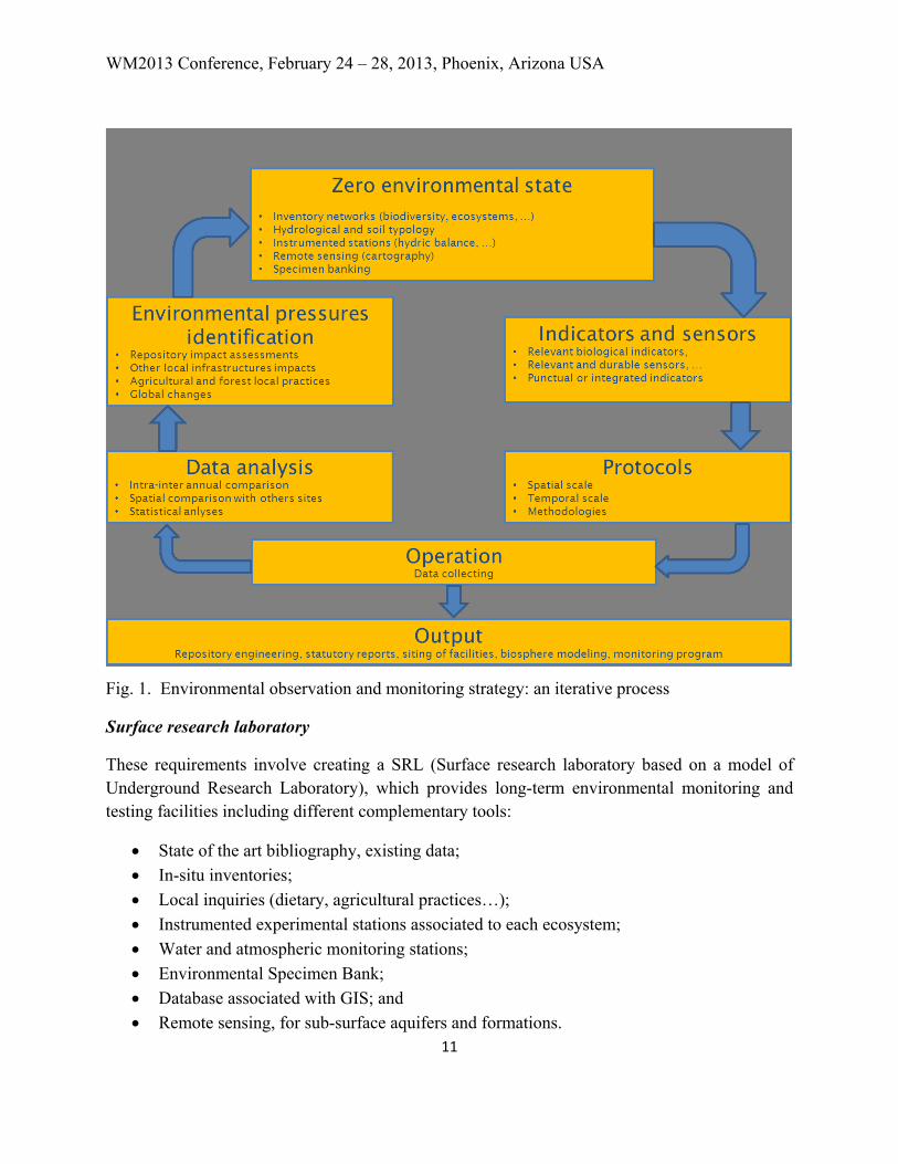
A long-term iterative process
The global monitoring strategy is an iterative process which includes different steps (Figure 1) :
• Zero environmental state definition • Indicators and sensors selection • Protocols definition • Data collecting • Data analysis • Environmental pressures identification.
The outputs of this strategy aims at addressing objectives already identified and output deliverables such as environmental impact assessment report, potential localization for facilities, hydrological and biosphere modeling,…etc.
WM2013 Conference, February 24 – 28, 2013, Phoenix, Arizona USA
11
Fig. 1. Environmental observation and monitoring strategy: an iterative process
Surface research laboratory
These requirements involve creating a SRL (Surface research laboratory based on a model of Underground Research Laboratory), which provides long-term environmental monitoring and testing facilities including different complementary tools:
• State of the art bibliography, existing data; • In-situ inventories; • Local inquiries (dietary, agricultural practices…); • Instrumented experimental stations associated to each ecosystem; • Water and atmospheric monitoring stations; • Environmental Specimen Bank; • Database associated with GIS; and • Remote sensing, for sub-surface aquifers and formations.

WM2013 Conference, February 24 – 28, 2013, Phoenix, Arizona USA
12
Inventory and monitoring networks
Different spatial scales: areas to be monitored
The global/oveall area to be observed includes surface perimeter corresponding to the underground and surface facilities, plus a few kilometers including potential surface equipments or ramp/shaft facilities. For continental monitoring, it can be useful to integrate the entire watershed considered and enlarge monitoring in order to better control the hydrologic processes.
A near field area can be defined to intensify some parameters monitoring such as biodiversity, soil or atmospheric monitoring. For example, OPE (Perennial Environmental Observatory) has two perimeters: one over an area of 900 km² including first potential underground facilities and a few watersheds and another perimeter 240 km² for more intensive monitoring. For sensitive or protected biodiversity species monitoring, the observation area can be restricted to surface facilities [5].
Define relevant indicators
The choice of the parameters to be measured is linked to the identified objectives. Data associated to these objectives are (Table II): meteorological data, water resources, flooding areas, urbanization, protected species localization, biomass, forest and agricultural yield, low level chemical and radiological background, particulates, biodiversity monitoring, etc. For each parameter, relevant biomarkers and sensors have to be defined. Integrated indicator such as bees and associated products, aquatic or terrestrial mosses or lichen are useful when considering historical and 'widespread' pollution.
Protocols
The protocols are based on existing international and national networks. For example, each Andra specific network (soil, forest, biodiversity...) is based on more than 100 monitored points inside the 240 km² intensive monitored area. This inventory and monitoring work is developed in close collaboration with local and national research centers, universities, local stakeholders (e.g. institutional, fishers, farmers, hunters, etc.).
Time scale: Duration and frequency
Representative reference initial environmental state can be considered to be reached over a period: ≥ 5 years to take into account climatic variability. Long(er) time series over few decades are useful for flooding or other specific meteorological reference parameters. The frequency of monitoring is dependent of the parameters and objectives, and should be optimized via research programs. For parameters considered in the national or European networks, frequency of monitoring is recommended.
WM2013 Conference, February 24 – 28, 2013, Phoenix, Arizona USA
13
Database
Information systems evolve very rapidly. Some simple interoperated databases have to be specifically developed to take into account the very long-term period of radioactive waste disposals operation. Special attention should be paid to database associated with Geographic Information System which allows an easy consultation notably by inhabitants (general public).
Environmental specimen bank
Specimen banking protocols are different regarding analytical objectives (trace metallic elements, organic compounds, radionuclides, ultra-trace elements, DNA, …) and need to reach high technological quality in order to preserve samples and ensure long term integrity. Different banking approaches have to be developed to address different objectives. Typically, there are three storage modes to address different analytical objectives: cryogeny (-150°C), deep-freezers (-80°C), dry storage (+18°C).
Storage equipment will have to provide a period beyond 30 years in order to establish very long time series of the samples. This capacity will allow re-analyses on the same sample over time, with use of new or more accurate analytical methods and further investigation of new pollutants and temporal trends. Strict handling protocols, specimen access policy and security, traceability, verification of specimen stability and record of data have already been designed and reviewed by the international community. Sampling strategy and diversity of specimen should be adapted to each case and site. Existing banking protocols are available but need to be adapted to each case.
Atmospheric station(s)
This station is dedicated to monitoring meteorological conditions, such as atmospheric compounds monitoring (liquid, gaseous, solid) that cover a large spatial and temporal scale (second/meter -> decades/thousand km). The localization of the station is crucial for effective representation of the different scales and in meeting the different criteria:
• Highest altitude of the monitoring area; • Major wind direction of the area; • Distance from perturbation sources (roads, inhabitation…); • Open field; and • Accessibility.
Water stations
On surface water monitoring, previous studies have demonstrated the need to investigate in details the temporal and spatial variability of water quality in order to better understand the

WM2013 Conference, February 24 – 28, 2013, Phoenix, Arizona USA
14
correlation between quality parameters and environmental conditions. This helps to define a basis relevant to future monitoring strategies. With this in place, monitoring stations for continuous in situ measurements of key water quality parameters can be recommended.
However, before deploying any probes in the field, a meteorological characterization of the selected in-situ probes has to be carried out first in controlled conditions in the laboratory, and second in real conditions in the field. Protocols have to be designed to assess the impact on measurements of various factors such as calibration drift, sample temperature and biofouling.
Ecosystem stations
Intensive instrumented stations of biogeochemical monitoring in typical ecosystem (such as forest and agriculture) often focus on energy’s stocks, gas and mass fluxes between soil, plant and the atmosphere. In forest ecosystem, they can be associated to a tower measuring canopy-air interface fluxes. The localization should be representative of the ecosystem of the observed zone, especially for soils and species. The most homogeneous area can be selected with resistivity measurements, forest essence planting characterization,…etc.
The agrosystem experimental site of Andra has been selected in order to provide criteria allowing agricultural research studies (e.g. homogenization of soil, proximity of agriculture and grassland), instrumentation and comparison with forest ecosystem. Some resistivity measurements on the plots have been realized and a resistivity map was used to aid siting of the experimental plots.
Lysimetric stations
Lysimeters represent an intermediate scale between controlled laboratory studies and in-situ studies. Their localization is less critical, although the selection of excavated soils is of importance. These have to be representative of the considered ecosystems. These are important as they contribute to the water-balance and long-term biogeochemical studies in agriculture, forestry and anthropogenic soils. They are instrumented to sample leachates in order to monitor chemical concentrations in the soils/materials in order to provide long-term information about the chemical and microbial processes and exchanges, chemicals and water mobility, chemicals interaction with the soil or with groundwater. A numbers of parameters are also measured by the lysimetric equipment such as pH, exchangeable capacity, ...etc.
MONITORING PROGRAM INTENSITY
The intensity of observation-monitoring depends on the parameter of concern, but also on timing such as at which stage/phase of the repository project. For example, the intensity is very important during the first few years in order to define and establish best practices (Table II).

WM2013 Conference, February 24 – 28, 2013, Phoenix, Arizona USA
15
Table II. Frequency of the different environmental surveys
Parameter Construction – 5 years
Environmental zero
state
Construction
stage
Operation
stage
Post-closing
stage
Meteorological parameters continuous continuous continuous
Suspended matter (atmospheric
and water)
Representative
background
Every year Every two
years
Terrestrial and avian fauna
inventory
Each year Every year Every two
years
Fishes population evaluation Each year (large
variability)
Water quality:
Metals and volatile organic
compounds
Representative
background
Radioactivity in biological
specimen
Once - Every two
years
Every five years
Ecosystem transfer processes Continuous Continuous Continuous Continuous
CONCLUSIONS
Depending on a country's regulatory systems, different types and levels of requirements may be required for defining the environmental monitoring system of a geological repository. In order to further reduce the discrepancies of the differing approaches adopted by different countries, it may be useful to consider defining a common baseline for the environmental monitoring system. This paper presents initial lessons learned from the French environment observatory located around the Meuse/Haute-Marne area and in operation since 2007, including some guidelines related to observation/monitoring practices that should be considered prior to the construction phase of the geological repository.
REFERENCES
1. INTERNATIONAL ATOMIC ENERGY AGENCY (2001). Monitoring of Geological Repositories for High Level Radioactive Waste, IAEA-TECDOC-1208, IAEA, Vienna.
2. IAEA Safety Standards (2011). Disposal of Radioactive Waste for protecting people and the environment Specific Safety Requirements. No. SSR-5.
3. POSIVA (2011). Monitoring at Olkiluoto – an updated program for the period before repository operation, Chapter 7: Monitoring Programme For Surface Environment.
4. IAEA Safety Standards (2005). Environmental and Source Monitoring for Purposes of Radiation Protection, Safety Guide, No. RS-G-1.8.

WM2013 Conference, February 24 – 28, 2013, Phoenix, Arizona USA
16
5. Andra (2012). Dossier 2012 – Cigéo, Stratégie d’observation-surveillance des ouvrages du stockage et de son environnement