a review of nullarbor regional reserve no responsibility for the accuracy, completeness or fitness...
TRANSCRIPT
www.environment.sa.gov.au
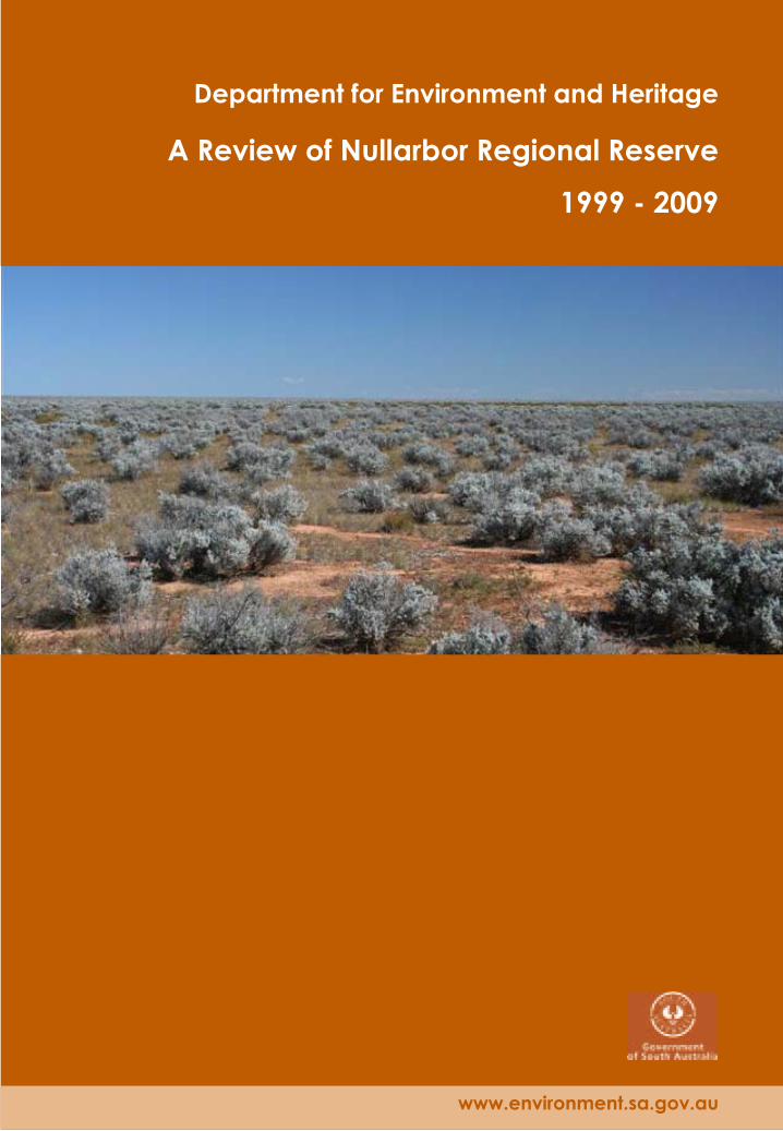
Department for Environment and Heritage
A Review of Nullarbor Regional Reserve
1999 - 2009
This review has been prepared to meet the requirements of section 34A of the National Parks and Wildlife Act 1972
For further information please contact: Department for Environment and Heritage Phone Information Line (08) 8204 1910, or see SA White Pages for your local Department for Environment and Heritage office.
Online information available at: http://www.environment.sa.gov.au
Permissive Licence
© State of South Australia through the Department for Environment and Heritage. Apart from fair dealings and other uses permitted by the Copyright Act 1968 (Cth), no part of this publication may be reproduced, published, communicated, transmitted, modified or commercialised without the prior written approval of the Department for Environment and Heritage.
Written requests for permission should be addressed to: Design and Production Manager Department for Environment and Heritage GPO Box 1047 Adelaide SA 5001 Disclaimer
While reasonable efforts have been made to ensure the contents of this publication are factually correct, the Department for Environment and Heritage makes no representations and accepts no responsibility for the accuracy, completeness or fitness for any particular purpose of the contents, and shall not be liable for any loss or damage that may be occasioned directly or indirectly through the use of or reliance on the contents of this publication.
Reference to any company, product or service in this publication should not be taken as a Departmental endorsement of the company, product or service.
Photography: Bluebush plain, Sue Barker
©8700. Department for Environment and Heritage
ISBN: 978 1 921466 43 4 . July 2009

FOREWORD Nullarbor Regional Reserve, located in the far west of the State, was proclaimed in 1989 and is one of South Australia’s largest protected areas. The reserve is a key component of the biological corridor connecting extensive intact areas from the Western Australia border to central Eyre Peninsula. The area is of great significance to the traditional owners of the land and continues to be an important connection of their living culture today.
This is the second ten-year review of Nullarbor Regional Reserve assessing the impacts of resource use on the conservation values of the land. Currently, the resource uses within the reserve are conservation, mining exploration activity, ground water extraction, tourism and cultural activities. Generally, there has been little change in the impacts of activities on the reserve in the last ten years.
This review discusses the impacts of mining, tourism and cultural use on the natural and cultural values of the reserve and highlights the management practices in place which seek to minimise those impacts. The review also provides recommendations for the future status and management of Nullarbor Regional Reserve.
This review has been tabled in both Houses of Parliament to meet the requirements of section 34A (5) of the National Parks and Wildlife Act 1972.
HON JAY WEATHERILL MP
MINISTER FOR ENVIRONMENT AND CONSERVATION
A Review of Nullarbor Regional Reserve 1999 - 2009 i


TABLE OF CONTENTS FOREWORD......................................................................................................................................................... i TABLE OF CONTENTS......................................................................................................................................... iii 1 ......................................................................................................................................... 1 INTRODUCTION
1.1 ......................................................................................................................... 1 Regional Reserves1.2 ............................................................................................. 1 Purpose and Scope of this Review
2 ............................................................................................................ 3 NULLARBOR REGIONAL RESERVE2.1 .......................................................................................................................... 3 Location and Size2.2 ............................................................................................................................ 3 Natural Features2.3 ........................................................................................................................... 3 Cultural Features2.4 ....................................................................................................................... 3 Economic Features2.5 ...................................................................................................................................... 4 Native Title
3 .......................................................................................................................................... 6 RESOURCE USE3.1 ........................................................................................................................................... 6 Minerals3.2 ............................................................................................................................................ 6 Tourism3.3 ......................................................................................................................................... 7 Research3.4 ...............................................................................................................................7 Indigenous Use
4 ...................................................................................................................... 10 ASSESSMENT OF IMPACTS4.1 .............................................................................................. 10 Impacts on the Natural Features
4.1.1 ........................................................................................... 10 Disturbance of Vegetation4.1.2 ......................................................................................................... 10 Disturbance of Soil4.1.3 ................................................................................................................ 10 Visual Impacts4.1.4 ........................................................................................................ 10 Impacts on Wildlife4.1.5 .................................................................................................. 11 Changes to Hydrology
4.2 ............................................................................................. 12 Impacts on the Cultural Features
5 ......................................................... 13 IMPACT OF RESOURCE USE ON THE ECONOMY OF THE STATE5.1 .......................................................................................................................................... 13 Mineral5.2 .......................................................................................................................................... 13 Tourism
6 ............................................................................................................................. 14 RECOMMENDATIONS6.1 .................................................................................................... 14 Reserve Status under the Act6.2 ............................................................. 14 Future Management of Nullarbor Regional Reserve
7 ......................................................................................................... 15 REFERENCES AND BIBLIOGRAPHYAPPENDIX A: INTERPRETATION OF THE PROVISIONS OF SECTION 34A OF THE ACT........................ 16
LIST OF FIGURES Figure 1 Nullarbor Regional Reserve - Location........................................................................................... 5
Figure 2 Nullarbor Regional Reserve - Mining Exploration Activity.. ......................................................... 8
Figure 3 Nullarbor Regional Reserve - Mining Exploration Activity Infrastructure Development. .........9
A Review of Nullarbor Regional Reserve 1999 - 2009 iii


1 INTRODUCTION 1.1 Regional Reserves Reserves are established under the National Parks and Wildlife Act 1972 and managed by the Director of National Parks and Wildlife subject to any direction by the Minister for Environment and Conservation or the Chief Executive of the Department for Environment and Heritage (DEH). When managing reserves, the Director is required under section 37 of the National Parks and Wildlife Act 1972 to have regard to, and provide actions that are consistent with the following objectives of management stated in the Act:
- preservation and management of wildlife;
- preservation of historic sites, objects and structures of historic or scientific interest within reserves;
- preservation of features of geographical, natural or scenic interest;
- destruction of dangerous weeds and the eradication or control of noxious weeds and exotic plants;
- control of vermin and exotic animals;
- control and eradication of disease of animals and vegetation;
- prevention and suppression of bush fires and other hazards;
- encouragement of public use and enjoyment of reserves and education in, and a proper understanding and recognition of, their purpose and significance;
- generally, the promotion of the public interest;
- in relation to managing a regional reserve, to permit the utilisation of natural resources while conserving wildlife and the natural or historic features of the land; and
- preservation and protection of Aboriginal sites, features, objects and structures of spiritual or cultural significance within reserves.
Section 38 of the Act states that a management plan is required for each reserve. A management plan should set forth proposals in relation to the management and improvement of the reserve and the methods by which it is intended to accomplish the objectives of the Act in relation to that reserve.
The National Parks and Wildlife Act 1972 was amended in 1987 to make provision for multiple-use reserves by creating an additional classification of Regional Reserve. The concept behind regional reserves was to have conservation recognised as a legitimate land use alongside pre-existing and future land uses such as mining and pastoralism. There are seven regional reserves constituted between 1988 and 1993.
Regional reserves meet the requirements of the IUCN (International Union for the Conservation of Nature) Protected Area Management Category VI: Protected area with sustainable use of natural resources. Category VI protected areas ‘conserve ecosystems and habitats, together with associated cultural values and traditional natural resource management systems. They are generally large, with most of the area in a natural condition, where a proportion is under sustainable natural resource management and where low-level non-industrial use of natural resources is compatible with nature conservation is seen as one of the main aims of the area’ (Dudley, 2008).
The key challenge with regional reserves is protecting and maintaining biological diversity and cultural values whilst finding a sustainable balance with the impacts on and utilisation of the reserve’s features.
1.2 Purpose and Scope of this Review Pursuant to section 34A (5) of the National Parks and Wildlife Act 1972, the Minister responsible for the administration of the Act must, in relation to regional reserves, at intervals of not more than ten years, prepare a report:
- assessing the impact of the utilisation of natural resources on the conservation of the wildlife and natural and historical features of the reserve;
A Review of Nullarbor Regional Reserve 1999 - 2009 1

- assessing the impact or the potential impact of the utilisation of the natural resources of the reserve on the economy of the State; and
- making recommendations as to the future status under this Act of the land constituting the reserve.
The Minister is required to table the report before each House of Parliament.
This is the second ten-year review of Nullarbor Regional Reserve since its constitution in 1989 and has been prepared to assess the impacts of utilisation of natural resources on the wildlife, natural and historical features of that reserve and on the State’s economy during the period of 1999-2009. It follows many of the principles adopted for the first review (refer Appendix A).
Recommendations for management, while not a requirement in the context of the section 34A report, are nonetheless included in this report for the purpose of foreshadowing those issues that will need to be addressed in the management plan for this reserve.
The report structure is described below.
- Chapter 2 provides a description of location and the natural, cultural and economic features of the reserve.
- Chapter 3 summarises the resource use in the last ten years.
- Chapter 4 identifies the impacts of resource use of the reserve and assesses those impacts on the natural and cultural features of the reserve. This chapter also describes the management strategies that have been implemented.
- Chapter 5 provides a summary of the impacts of the utilisation of the natural resources of the reserve on the economy of the State.
- Chapter 6 provides recommendations for the future status and management of the reserve.
2 A Review of Nullarbor Regional Reserve 1999 - 2009

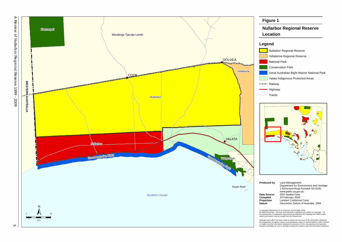
2 NULLARBOR REGIONAL RESERVE 2.1 Location and Size Nullarbor Regional Reserve (2 268 914 ha) is located in the far west of South Australia (Figure 1). The reserve was proclaimed under the National Parks and Wildlife Act 1972 on 31 August 1989. It is the second largest reserve in South Australia and represents 23% of the total area of regional reserves. It is bordered to the north by Maralinga Aboriginal Lands, east by Yellabinna Regional Reserve, to the south by Nullarbor National Park and Yalata Aboriginal Lands, and to the west by the Western Australian border (Figure 1).
2.2 Natural Features The reserve is a key component of the biological corridor connecting extensive intact areas in South-Western Australia. Limited post-settlement land use has resulted in the uniformly high wilderness quality of the area.
The majority of the reserve falls within the Nullarbor Plain environmental association (Laut et al., 1977), which is described as a structural limestone plain associated with occasional sink holes and caves. The vegetation cover is mainly a low chenopod shrub understorey (predominantly saltbush (Atriplex spp.) and bluebush (Maireana spp.)) and occasionally an open scrub on red calcareous loams.
The Nullarbor plain is home to over 390 species of plants and 160 species of animals of which nine species recorded in the reserve are recognised as species of conservation significance at national and state levels (EQUEST, 2009). This includes the nationally and state rated vulnerable Slender-billed Thornbill (Acanthiza iredalei iredalei), vulnerable Thick-billed Grasswren (Amytornis textiles) and State vulnerable Ridged Noon-flower (Sarcozona bicarinata) and Sandalwood (Santalum spicatum).
Nullarbor Regional Reserve (and Nullarbor National Park) also constitute the South Australian portion of the world’s largest arid karst (cave) province. In particular, the reserve protects part of the arid karst landscape and the unique fauna dependent on the cave environment for survival.
2.3 Cultural Features Indigenous Heritage
Both the Nullarbor Regional Reserve and National Park protect many Aboriginal cultural sites associated with the world’s largest semi-arid cave landscape. There are 24 sites listed under the Aboriginal Heritage Act 1988 within the reserve, including sites still used for cultural purposes by initiated members of local Aboriginal communities.
Non-Indigenous Heritage
The harsh environment, isolation and lack of available water resulted in very brief attempts to settle land in the reserve and throughout the broader Nullarbor Plain. Consequently, the reserve contains few relics of pastoral life and to date no features have been entered in the State Heritage Register.
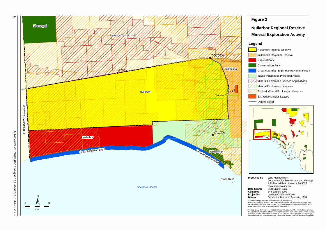
2.4 Economic Features The region is prospective for a range of mineral commodities including heavy mineral sands, uranium, iron ore, copper, gold, diamonds, nickel, chromium and platinoids. Over the past ten years a total of 23 mineral exploration licences have been granted over the reserve. On-ground activities have comprised a number of exploration and resource evaluation programs for these commodities.
In recent years the Eucla Basin, which extends into the north-eastern corner of the reserve, has been identified as a key mineral sands province. The development of the Jacinth-Ambrosia Mineral Sands Project in Yellabinna Regional Reserve has involved the granting of mining tenements and other licences to support the development of the mine. Activities that have impacted upon the reserve include: the upgrade of Ooldea Road and creation of access tracks and borrow pits associated with excavating material for the road upgrade; and borefield developments for providing water to the mine. These activities are restricted to the eastern boundary of the reserve (see Figure 2).
A Review of Nullarbor Regional Reserve 1999 - 2009 3

The Nullarbor Regional Reserve is only lightly explored and its petroleum, greenhouse gas storage and geothermal potential is poorly understood. No petroleum or geothermal licensing or activities have occurred in the Nullarbor Regional Reserve in the past ten-year period. Although travellers using the Eyre Highway rarely depart from the main road, a small number of visitors venture into the reserve. The remoteness and ‘undisturbed’ appeal of the reserve attracts a small number of self-reliant visitors. Visitor use is seasonal and anecdotal evidence suggests that little change in numbers of tourists to the reserve has occurred over the last ten years. The flow-on economic benefits in local sales of fuel, food and accommodation contribute directly to the regional economy. 2.5 Native Title There is currently one Native Title claim (Far West Claim) which includes the reserve.
4 A Review of Nullarbor Regional Reserve 1999 - 2009
Southern Ocean
Nullarbor
Yellabinna
Mamungari
Nullarbor
WahgunyahGreat Australian Bight Great Australian Bight
Nuyts Reef
COOK
OOLDEA
YALATA
5A
Review of N
ullarbor Regional Reserve 1999 - 2009
PAMS Managem ent Plan
Nullarbor Regional ReserveFigure 1
Location Legend
Nullarbor Regional Reserve
Yellabinna Regional Reserve
National Park
Conservation Park
Great Australian Bight Marine National Park
Yalata Indigenous Protected Areas
Railway
Highway
Tracks
0 35
Kms
±
Maralinga Tjarutja Lands
© Copyright Department for Environment and Heritage 2008.All Rights Reserved. All works and information displayed are subject to Copyright. Forthe reproduction Or publication beyond that permitted by the Copyright Act 1968 (Cwlth)written permission must be sought from the Department.
Although every effort has been made to ensure the accuracy of the information displayed,the Department, its agents, officers and employees make no representations, either expressor implied, that the information displayed is accurate or fit for any purpose and expresslydisclaims all liability for loss or damage arising from reliance upon the information displayed.
Produced by
Data Source Compiled Projection Datum
Land ManagementDepartment for Environment and Heritage1 Richmond Road Keswick SA 5035www.parks.sa.gov.auDEH Spatial Data24 February 2009Lambert Conformal ConicGeocentric Datum of Australia, 1994
WESTERN AUSTRALIA
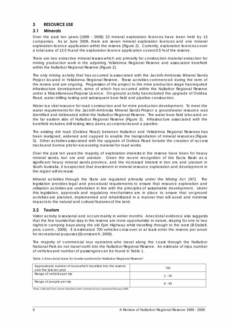
3 RESOURCE USE 3.1 Minerals Over the past ten years (1999 - 2008) 23 mineral exploration licences have been held by 13 companies. As at June 2009, there are seven mineral exploration licences and one mineral exploration licence application within the reserve (Figure 2). Currently, exploration licences cover a total area of 13.5 % and the exploration licence application covers 0.5 % of the reserve.
There are two extractive mineral leases which are primarily for construction material extraction for mining production work in the adjoining Yellabinna Regional Reserve and associated borefield within the Nullarbor Regional Reserve (Figure 2).
The only mining activity that has occurred is associated with the Jacinth-Ambrosia Mineral Sands Project located in Yellabinna Regional Reserve. These activities commenced during the term of the review and are ongoing. Progression of the project to the mine production stage has required infrastructure development, some of which has occurred within the Nullarbor Regional Reserve under a Miscellaneous Purpose Licence. On-ground activity has included the upgrade of Ooldea Road, water drilling testing and subsequent bore field and pipeline construction.
Water is a vital resource for road construction and for mine production development. To meet the water requirements for the Jacinth-Ambrosia Mineral Sands Project a groundwater resource was identified and delineated within the Nullarbor Regional Reserve. The water bore field is located on the far eastern side of Nullarbor Regional Reserve (Figure 3). Infrastructure associated with the borefield includes; drill testing sites, dams, access tracks and a pipeline.
The existing dirt road (Ooldea Road) between Nullarbor and Yellabinna Regional Reserves has been realigned, widened and capped to enable the transportation of mineral resources (Figure 3). Other activities associated with the upgrade of Ooldea Road include the creation of access tracks and borrow pits for excavating material for road works.
Over the past ten years the majority of exploration interests in the reserve have been for heavy mineral sands, iron ore and uranium. Given the recent recognition of the Eucla Basin as a significant heavy mineral sands province, and the increased interest in iron ore and uranium in South Australia, it is expected that investment in mineral resource exploration and development in the region will increase.
Mineral activities through the State are regulated primarily under the Mining Act 1971. The legislation provides legal and procedural requirements to ensure that resource exploration and utilisation activities are undertaken in line with the principles of sustainable development. Under this legislation, approvals and regulatory mechanisms are in place to ensure that on-ground activities are planned, implemented and rehabilitated in a manner that will avoid and minimise impacts to the natural and cultural features of the land.
3.2 Tourism Visitor activity is seasonal and occurs mainly in winter months. Anecdotal evidence also suggests that the few tourists that stay in the reserve are more opportunistic in nature, staying for one to two nights in camping bays along the old Eyre Highway whist travelling through to the west (B Dalzell, pers. comm., 2009). It is estimated 700 vehicles cross over or at least enter the reserve per anum for recreational purposes (Econsearch, 2009).
The majority of commercial tour operators who travel along the coast through the Nullarbor National Park do not travel north into the Nullarbor Regional Reserve. An estimate of trips, number of vehicles and number of passengers can be found in Table 1.
Table 1 Anecdotal data for tourist numbers for Nullarbor Regional Reserve*
Approximate number of tours which travelled into the reserve over the last ten year 742
Range of vehicles per trip 1 - 16
Range of people per trip 6 - 40
*Data collected from phone interviews with commercial tour operators February 2009.
6 A Review of Nullarbor Regional Reserve 1999 - 2009

Information gathered from commercial tour operators indicates that visitors usually travel through the Nullarbor Regional Reserve in small self-reliant four-wheel drive groups. Activities undertaken by these groups, which are considered to be of low impact, include bird-watching, walking and general appreciation of the wilderness. Anecdotal advice from commercial tour operators and Departmental staff indicates that visitor numbers have not increased in the last ten years.
3.3 Research Some access to the reserve is for specialist interest and research purposes. Over the past ten years 42 scientific permits have been issued compared to 30 from the previous ten years. Permits are primarily for gathering field data and include low impact activities such as vegetation and fauna monitoring, small-scale sample collecting and radio tracking.
3.4 Indigenous Use Indigenous communities use the reserve for activities such as hunting and other cultural purposes, and use the network of existing tracks for a range of purposes including travel between Yalata and Oak Valley. Travel by members of the Aboriginal community across the reserve is estimated to be 800 vehicles per year (Econsearch, 2009).
Construction of an Aboriginal cultural heritage track within the Nullarbor Regional Reserve has occurred in association with the Jacinth-Ambrosia Mineral Sands Project in Yellabinna Regional Reserve. The cultural track connects with a number of pre-existing tracks.
Hunting and gathering are permitted in the reserve pursuant to section 68 d (3) and (4) of the National Parks and Wildlife Act 1972. The number of animals or plants taken is unknown however this practice is considered to have minimal impact in the overall landscape (B Dalzell, pers. comm., 2009).
A Review of Nullarbor Regional Reserve 1999 - 2009 7
Southern Ocean
Nullarbor
Yellabinna
Mamungari
Nullarbor
WahgunyahGreat Australian Bight Great Australian Bight
Nuyts Reef
COOK
OOLDEA
YALATA
8A
Review of N
ullarbor Regional Reserve 1999 - 2009
PAMS Managem ent Plan
LegendNullarbor Regional Reserve
Yellabinna Regional Reserve
National Park
Conservation Park
Great Australian Bight MarineNational Park
Yalata Indigenous Protected Areas
Mineral Exploration Licence Applications
Mineral Exploration Licences
Expired Mineral Exploration Licences
Extractive Mineral Leases
Ooldea Road
0 35
Kms
±
Maralinga Tjarutja Lands
Nullarbor Regional ReserveFigure 2
Mineral Exploration Activity
WE
STE
RN
AU
STR
ALIA
© Copyright Department for Environment and Heritage 2008.All Rights Reserved. All works and information displayed are subject to Copyright. Forthe reproduction Or publication beyond that permitted by the Copyright Act 1968 (Cwlth)written permission must be sought from the Department.
Although every effort has been made to ensure the accuracy of the information displayed,the Department, its agents, officers and employees make no representations, either expressor implied, that the information displayed is accurate or fit for any purpose and expresslydisclaims all liability for loss or damage arising from reliance upon the information displayed.
Produced by
Data Source Compiled Projection Datum
Land ManagementDepartment for Environment and Heritage1 Richmond Road Keswick SA 5035www.parks.sa.gov.auDEH Spatial Data24 February 2009Lambert Conformal ConicGeocentric Datum of Australia, 1994

OOLDEA
YALATA
9A
Review of N
ullarbor Regional Reserve 1999 - 2009
PAMS Managem ent Plan
LegendNullarbor Regional Reserve
Yellabinna Regional Reserve
Yalata Indigenous Protected Areas
Mineral Exploration Licence Applications
Mineral Exploration Licences
Extractive Mineral Leases
Railway
Ooldea Road
Highway
Tracks
Borefield Pipeline and Access Tracks
Mineral SandsMining Project
Nullarbor Regional ReserveFigure 3
Mineral Exploration Infrastructure Development
© Copyright Department for Environment and Heritage 2008.All Rights Reserved. All works and information displayed are subject to Copyright. Forthe reproduction Or publication beyond that permitted by the Copyright Act 1968 (Cwlth)written permission must be sought from the Department.
Although every effort has been made to ensure the accuracy of the information displayed,the Department, its agents, officers and employees make no representations, either expressor implied, that the information displayed is accurate or fit for any purpose and expresslydisclaims all liability for loss or damage arising from reliance upon the information displayed.
Produced by
Data Source Compiled Projection Datum
Land ManagementDepartment for Environment and Heritage1 Richmond Road Keswick SA 5035www.parks.sa.gov.auDEH Spatial Data7 July 2009Lambert Conformal ConicGeocentric Datum of Australia, 1994
0 15
Kms
±
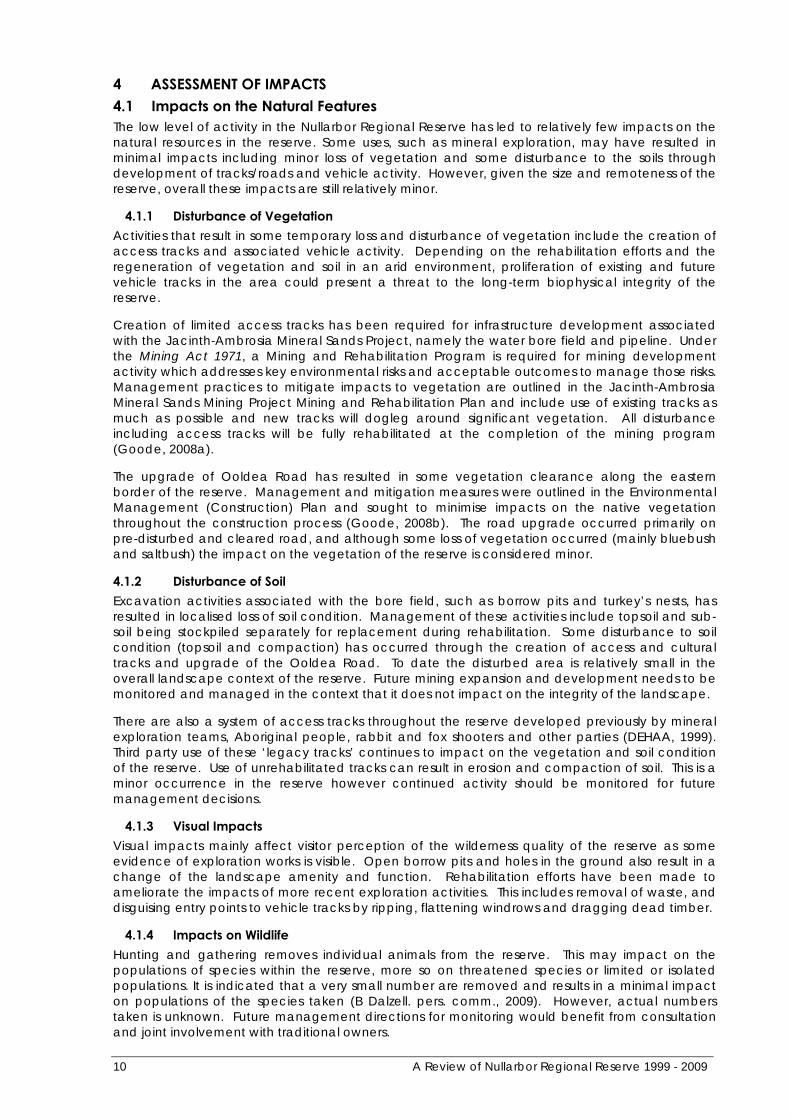
4 ASSESSMENT OF IMPACTS 4.1 Impacts on the Natural Features The low level of activity in the Nullarbor Regional Reserve has led to relatively few impacts on the natural resources in the reserve. Some uses, such as mineral exploration, may have resulted in minimal impacts including minor loss of vegetation and some disturbance to the soils through development of tracks/roads and vehicle activity. However, given the size and remoteness of the reserve, overall these impacts are still relatively minor.
4.1.1 Disturbance of Vegetation Activities that result in some temporary loss and disturbance of vegetation include the creation of access tracks and associated vehicle activity. Depending on the rehabilitation efforts and the regeneration of vegetation and soil in an arid environment, proliferation of existing and future vehicle tracks in the area could present a threat to the long-term biophysical integrity of the reserve.
Creation of limited access tracks has been required for infrastructure development associated with the Jacinth-Ambrosia Mineral Sands Project, namely the water bore field and pipeline. Under the Mining Act 1971, a Mining and Rehabilitation Program is required for mining development activity which addresses key environmental risks and acceptable outcomes to manage those risks. Management practices to mitigate impacts to vegetation are outlined in the Jacinth-Ambrosia Mineral Sands Mining Project Mining and Rehabilitation Plan and include use of existing tracks as much as possible and new tracks will dogleg around significant vegetation. All disturbance including access tracks will be fully rehabilitated at the completion of the mining program (Goode, 2008a).
The upgrade of Ooldea Road has resulted in some vegetation clearance along the eastern border of the reserve. Management and mitigation measures were outlined in the Environmental Management (Construction) Plan and sought to minimise impacts on the native vegetation throughout the construction process (Goode, 2008b). The road upgrade occurred primarily on pre-disturbed and cleared road, and although some loss of vegetation occurred (mainly bluebush and saltbush) the impact on the vegetation of the reserve is considered minor.
4.1.2 Disturbance of Soil Excavation activities associated with the bore field, such as borrow pits and turkey’s nests, has resulted in localised loss of soil condition. Management of these activities include topsoil and sub-soil being stockpiled separately for replacement during rehabilitation. Some disturbance to soil condition (topsoil and compaction) has occurred through the creation of access and cultural tracks and upgrade of the Ooldea Road. To date the disturbed area is relatively small in the overall landscape context of the reserve. Future mining expansion and development needs to be monitored and managed in the context that it does not impact on the integrity of the landscape.
There are also a system of access tracks throughout the reserve developed previously by mineral exploration teams, Aboriginal people, rabbit and fox shooters and other parties (DEHAA, 1999). Third party use of these ‘legacy tracks’ continues to impact on the vegetation and soil condition of the reserve. Use of unrehabilitated tracks can result in erosion and compaction of soil. This is a minor occurrence in the reserve however continued activity should be monitored for future management decisions.
4.1.3 Visual Impacts Visual impacts mainly affect visitor perception of the wilderness quality of the reserve as some evidence of exploration works is visible. Open borrow pits and holes in the ground also result in a change of the landscape amenity and function. Rehabilitation efforts have been made to ameliorate the impacts of more recent exploration activities. This includes removal of waste, and disguising entry points to vehicle tracks by ripping, flattening windrows and dragging dead timber.
4.1.4 Impacts on Wildlife Hunting and gathering removes individual animals from the reserve. This may impact on the populations of species within the reserve, more so on threatened species or limited or isolated populations. It is indicated that a very small number are removed and results in a minimal impact on populations of the species taken (B Dalzell. pers. comm., 2009). However, actual numbers taken is unknown. Future management directions for monitoring would benefit from consultation and joint involvement with traditional owners.
10 A Review of Nullarbor Regional Reserve 1999 - 2009
Another impact on wildlife is sub-surface excavations (borrow pits and turkeys nests) which can become sources of water for native wildlife and feral animals. A small number of borrow pits and turkeys nests are present in Nullarbor Regional Reserve. Artificial water sources may contribute to maintaining higher feral animal populations increasing competition and predation pressure on native fauna. Borrow pits and other water sources may also act as fatal traps for wildlife. Management around this risk has been addressed in the MARP (Operations) and the Ooldea Road North and Ooldea Bypass – Environmental Management (Construction) Plan including managing all sick and injured wildlife as required under the Animal Welfare Act 1985 and monitoring significant fauna sightings and recording the occurrence of injured or dead fauna (Goode and Doudle, 2009 and Goode, 2008b).
The development of Ooldea Road to provide transport infrastructure will result in an increased level of traffic. Greater accessibility facilitates a higher level of traffic and this may directly result in increased wildlife mortalities. This risk has been identified in the MARP (Operations) and addressed through the Fauna Management Plan (Goode, 2009). Management practises include a register of significant fauna sightings and deaths (Goode, 2009). Considering the significant size of the Jacinth-Ambrosia Mineral Sands Project, continued monitoring (including documentation on the register) of fauna injury and impact should continue and management strategies be put in place if required.
4.1.5 Changes to Hydrology The upgrade of Ooldea Road and Jacinth-Ambrosia Mineral Sands Project required substantial volumes of water to meet specific construction and engineering requirements. Currently, water is being extracted from one bore in the bore field. The palaeochannel aquifer to be used for the mine operation is located 41km from the nearest karst areas and is distinct from the main Eucla Basin. The closest known stygofauna site to the borefield is located within the Nullarbor cave system 470 – 520 km west of the project (Goode, 2009). The likelihood of impact to significant stygofauna is considered to be a low level of risk (Goode, 2009). However, greater quantities of water may be extracted from the Nullarbor paleochannels as the mine is established. Changes to hydrology have been identified as a key threat to the Nullarbor caves system, which is considered highly significant refugia for regional endemic and relict species (Morton, Short and Barker, 1995). Regulation and monitoring of ongoing and future water extraction practices will be done to ensure impacts on the hydrology of the Nullarbor palaeochannels is minimised.
A Review of Nullarbor Regional Reserve 1999 - 2009 11
4.2 Impacts on the Cultural Features Resource use of the reserve may have an impact on the cultural features, however mineral exploration techniques seek to minimise disturbance to the cultural and natural values of the reserve. Through the mineral exploration approval process a company must submit a Declaration of Environmental Factors which is assessed by both DEH and Primary Industries Resources South Australia. The Declaration of Environmental Factors must address cultural and heritage concerns and outline management practises such as heritage site surveys for all project areas and avoidance of sites of cultural significance.
The previous ten-year review identified some visitor impacts including vehicles driving over archaeological scatter sites, litter, and disturbance to significant cave sites. Although there has been little monitoring within the last ten years of associated impacts on the cultural features, the remote location and low levels of visitation provide a buffer against damage. However, the potential for damage to significant sites, particularly caves, may require further management directions around protection of significant cultural sites and would benefit from consultation with traditional owners.
12 A Review of Nullarbor Regional Reserve 1999 - 2009
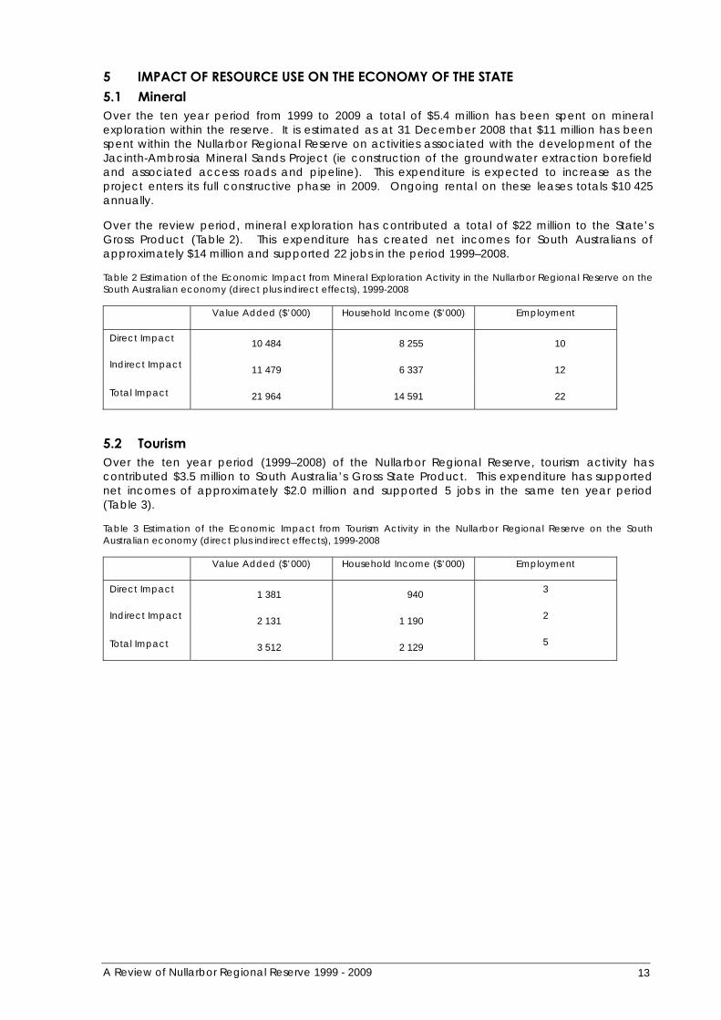
5 IMPACT OF RESOURCE USE ON THE ECONOMY OF THE STATE 5.1 Mineral Over the ten year period from 1999 to 2009 a total of $5.4 million has been spent on mineral exploration within the reserve. It is estimated as at 31 December 2008 that $11 million has been spent within the Nullarbor Regional Reserve on activities associated with the development of the Jacinth-Ambrosia Mineral Sands Project (ie construction of the groundwater extraction borefield and associated access roads and pipeline). This expenditure is expected to increase as the project enters its full constructive phase in 2009. Ongoing rental on these leases totals $10 425 annually.
Over the review period, mineral exploration has contributed a total of $22 million to the State’s Gross Product (Table 2). This expenditure has created net incomes for South Australians of approximately $14 million and supported 22 jobs in the period 1999–2008.
Table 2 Estimation of the Economic Impact from Mineral Exploration Activity in the Nullarbor Regional Reserve on the South Australian economy (direct plus indirect effects), 1999-2008
Value Added ($’000) Household Income ($’000) Employment
Direct Impact 10 484 8 255 10
Indirect Impact 11 479 6 337 12
Total Impact 21 964 14 591 22
5.2 Tourism Over the ten year period (1999–2008) of the Nullarbor Regional Reserve, tourism activity has contributed $3.5 million to South Australia’s Gross State Product. This expenditure has supported net incomes of approximately $2.0 million and supported 5 jobs in the same ten year period (Table 3).
Table 3 Estimation of the Economic Impact from Tourism Activity in the Nullarbor Regional Reserve on the South Australian economy (direct plus indirect effects), 1999-2008
Value Added ($’000) Household Income ($’000) Employment
Direct Impact 1 381 940 3
Indirect Impact 2 131 1 190 2
Total Impact 3 512 2 129 5
A Review of Nullarbor Regional Reserve 1999 - 2009 13

6 RECOMMENDATIONS 6.1 Reserve Status under the Act The Regional Reserve category was introduced to enable multiple-use of the land including conservation, mining exploration and activity, pastoral and tourism. Pastoral activities have never been carried out on the Nullarbor Regional Reserve and will not occur in the future due to a lack of reliable surface or underground water and very sparse vegetation.
Given tourism and exploration mining are the only resource uses, it is proposed that the regional reserve be re-classified as a conservation park which provides for existing and future rights of access for exploration and mining. This will have no impact on accessibility of this reserve for exploration and mining but is a more appropriate category for this reserve (DEH, 2005).
Therefore, it is recommended that the Nullarbor Regional Reserve be reclassified as a conservation park under the National Parks and Wildlife Act 1972.
6.2 Future Management of Nullarbor Regional Reserve Reserve Management Plan
There is no management plan for the Nullarbor Regional Reserve. A management plan is required to set objectives for reserve management, thereby addressing some of the operational issues noted in this review.
It is recommende d that the management plan for Nullarbor Regional Reserve be developed as soon as practicable.
14 A Review of Nullarbor Regional Reserve 1999 - 2009
7 REFERENCES AND BIBLIOGRAPHY Department for Environment, Heritage and Aboriginal Affairs (1999) A Review of Nullarbor Regional reserve 1989 – 1999. Adelaide, South Australia.
Department for Environment and Heritage (2005) Review of the Reserve Classification System. Adelaide, South Australia.
Dudley, N. (Editor) (2008) Guidelines for Applying Protected Area Management Categories. Gland, Switzerland: IUCN. x + 86pp.
Econsearch (2009) Economic Assessment of the Nullarbor Regional Reserve for Department of Environment and Heritage. Unpublished document.
EQUEST – Environmental Information, DEH (http://maps.deh.sa.gov.au:8084/eview/applet.jsp).
Goode, J. and Doudle, S. (2009) Jacinth-Ambrosia Mineral Sands Mining Project Mining and Rehabilitation Program (Operations). Parsons Brinckerhoff Australia Pty Limited (PB) 2009. Adelaide, South Australia.
Goode, J. (2008a) Jacinth-Ambrosia Mineral Sands Mining Project Mining and Rehabilitation Program (Construction). Parsons Brinckerhoff Australia Pty Limited (PB) 2008. Adelaide, South Australia.
Goode, J. (2008b) Ooldea Road North and Ooldea Bypass – Environmental Management (Construction) Plan. Parsons Brinckerhoff Australia Pty Limited (PB) 2008. Adelaide, South Australia.
Laut P, Heyligers P C, Keig G, Loffier E, Margules C, Scott R M and Sullivan M E (1977) Environments of South Australia Province 7. The Western Pastoral. CSIRO Div Land Use Research, Canberra.
Morton, S.R., Short, J. and Barker, R. D. (1995) Refugia for Biological Diversity in arid and Semi-arid Australia. Biodiversity Series, Paper No. 4. Biodiversity Unit, Department of the Environment, Sport and Territories, Canberra.
Wilderness Advisory Committee (2007) Nullarbor Region Wilderness Assessment Report, Adelaide, South Australia.
A Review of Nullarbor Regional Reserve 1999 - 2009 15
APPENDIX A: INTERPRETATION OF THE PROVISIONS OF SECTION 34A OF THE ACT
In undertaking this review, it has been necessary to ensure that the requirements of the Act are properly addressed. To facilitate this process, an interpretive analysis of section 34A was conducted as part of the 1999 review. This analysis still considered relevant and is provided below. This analysis has been used to guide the conduct of the review. It is also useful in guiding the readers of the report.
For the purposes of section 34A (5) (a) (i) and (ii), natural resources are considered to be:
• native vegetation which is utilised by pastoral stock for feed;
• petroleum and any mineralisation that requires the process of recovery to be undertaken by operations that take place within the boundaries of the reserve;
• landscapes and natural features including native vegetation, native animals, birds, invertebrates and other small fauna that are of recreational and educational value to visitors to the reserve and which are accessible to visitors in accordance with the management plan for the reserve; and
• surface and sub-surface water recovered from within the boundaries of the reserve.
For the purposes of section 34A (5) (a) (i) and (ii), utilisation of natural resources is taken to mean:
• recovery (petroleum), mining, grazing (pastoralism), environmental appreciation and recreational activity (tourism) and water recovery and use (general) and includes the infrastructure necessary to facilitate such utilisation;
• the recovery and utilisation of water prior to its inflow to the reserve; and
• where such utilisation is consistent with the specific objective in the Act in relation to the management of regional reserves, that is to say ‘to permit the utilisation of natural resources while conserving wildlife and the natural or historic features of the land’ (section 37(j)).
For the purposes of section 34A (5) (a) (i), i.e. in the context of conservation, impact of utilisation is taken to mean:
• the effects upon the condition of the wildlife and natural features of the reserve and the management strategies that are considered necessary and adequately to sustainable conserve the wildlife and natural features of the reserve and,
• the effect upon the approach taken to managing the wildlife and natural resources of the reserve as a response to a regime that provides for land uses other than those characteristic of other classifications of reserve under the Act.
For the purposes of section 34A (5) (a) (i), conservation of natural and historical features of the reserve is to have such a meaning that is consistent with the relevant objectives for managing reserves as set out in section 37 of the Act, the relevant objectives being:
• the preservation and management of wildlife;
• the preservation of historic sites, objects and structures of historic or scientific interest within reserves;
• the preservation of features geographical, natural or scenic interest.
and where such preservation is undertaken in accordance with other objectives of the Act which address the deleterious impact of weeds and exotic plants, vermin and exotic animals, diseases of animals and vegetation, and bush fires and other hazards.
For the purposes of section 34A (5) (a) (ii), i.e. in the context of the economy of the State, impact of utilisation is taken to mean:
• the contribution of utilisation to the economy of the State in dollar terms; and
• any offsets to benefits that might be occasioned by one form of utilisation as a result of another.
16 A Review of Nullarbor Regional Reserve 1999 - 2009

For the purposes of section 34A (5) (a) (iii), the future status under this Act of the land constituting the reserve is taken to mean the classification of the reserve under Part 3, Division 1-4 and 4A of the Act, the classifications available being National Park (Division 1), Conservation Park (Division 2), Game Reserve (Division 3), Recreation Park (Division 4) and Regional Reserve (Division 4A).
Further, for the purposes of section 34A (5) (a) (iii), recommendations as to the future status of the reserve are taken to relate to recommendations made in consideration of:
• the original intent of the reserve classification in providing for the management of the reserve for the purpose of conserving wildlife and natural features and utilising natural resources; and
• any factors that as a result of the review, significantly appear to work against the purpose of the Regional Reserve classification in providing direction for, and facilitating the management of, the reserve.
While the Act, at section 34A, does not provide for the framing of recommendations regarding the ongoing management of the reserve, section 38 of the Act does provide for the preparation and periodic review of reserve management plans.
A Review of Nullarbor Regional Reserve 1999 - 2009 17