a review of unoccupied aerial vehicle use in wetland
TRANSCRIPT
UC BerkeleyUC Berkeley Previously Published Works
TitleA review of unoccupied aerial vehicle use in wetland applications: Emerging opportunities in approach, technology, and data
Permalinkhttps://escholarship.org/uc/item/6mn9j43s
JournalDrones, 5(2)
ISSN2504-446X
AuthorsDronova, IKislik, CDinh, Zet al.
Publication Date2021-06-01
DOI10.3390/drones5020045 Peer reviewed
eScholarship.org Powered by the California Digital LibraryUniversity of California

drones
Review
A Review of Unoccupied Aerial Vehicle Use in WetlandApplications: Emerging Opportunities in Approach,Technology, and Data
Iryna Dronova 1,2,* , Chippie Kislik 1 , Zack Dinh 2 and Maggi Kelly 1,3
�����������������
Citation: Dronova, I.; Kislik, C.;
Dinh, Z.; Kelly, M. A Review of
Unoccupied Aerial Vehicle Use in
Wetland Applications: Emerging
Opportunities in Approach,
Technology, and Data. Drones 2021, 5,
45. https://doi.org/10.3390/
drones5020045
Academic Editor:
Arturo Sanchez-Azofeifa
Received: 30 April 2021
Accepted: 23 May 2021
Published: 25 May 2021
Publisher’s Note: MDPI stays neutral
with regard to jurisdictional claims in
published maps and institutional affil-
iations.
Copyright: © 2021 by the authors.
Licensee MDPI, Basel, Switzerland.
This article is an open access article
distributed under the terms and
conditions of the Creative Commons
Attribution (CC BY) license (https://
creativecommons.org/licenses/by/
4.0/).
1 Department of Environmental Sciences, Policy and Management, Rausser College of Natural Resources,University of California, Berkeley, CA 94720, USA; [email protected] (C.K.); [email protected] (M.K.)
2 Department of Landscape Architecture & Environmental Planning, College of Environmental Design,University of California, Berkeley, CA 94720, USA; [email protected]
3 Division of Agriculture and Natural Resources, University of California, Berkeley, CA 94720, USA* Correspondence: [email protected]
Abstract: Recent developments in technology and data processing for Unoccupied Aerial Vehicles(UAVs) have revolutionized the scope of ecosystem monitoring, providing novel pathways to fill thecritical gap between limited-scope field surveys and limited-customization satellite and piloted aerialplatforms. These advances are especially ground-breaking for supporting management, restora-tion, and conservation of landscapes with limited field access and vulnerable ecological systems,particularly wetlands. This study presents a scoping review of the current status and emergingopportunities in wetland UAV applications, with particular emphasis on ecosystem managementgoals and remaining research, technology, and data needs to even better support these goals inthe future. Using 122 case studies from 29 countries, we discuss which wetland monitoring andmanagement objectives are most served by this rapidly developing technology, and what workflowswere employed to analyze these data. This review showcases many ways in which UAVs mayhelp reduce or replace logistically demanding field surveys and can help improve the efficiencyof UAV-based workflows to support longer-term monitoring in the face of wetland environmentalchallenges and management constraints. We also highlight several emerging trends in applications,technology, and data and offer insights into future needs.
Keywords: wetland; unoccupied aerial vehicle; UAV; UAS; drone; management; conservation;restoration; monitoring; high spatial resolution
1. Introduction
Unoccupied aerial vehicles (UAVs) have emerged in the global remote sensing com-munity as small, flying robots that can access dangerous or remote regions, capture high-resolution imagery, and facilitate environmental monitoring and research ranging frombroad applications in agricultural management [1] to specialized marine mammal behav-ioral ecology [2]. UAVs are beneficial to environmental monitoring because they bridge theconstraints in complex, dynamic, limited-access environments that historically have beenchallenging to survey [3]. Furthermore, they reduce the amount of time and labor expendedon surveying and sampling on the ground [4–7], providing time for targeted managerialactivities that may otherwise be overlooked, such as restoration assessments [8–11]. In re-cent years, technological advances in UAV instruments such as greater spectral complexityvia LiDAR and multispectral sensors and increased volumetric estimations from Structurefrom Motion (SfM) photogrammetric techniques have transformed applications of UAVs inenvironmental research [12]. Newer UAV applications in environmental research involvinghyperspectral sensing have also expanded species-related analyses such as invasive plantevaluations [13] and mangrove species detection [14,15], although sensor costs and storage
Drones 2021, 5, 45. https://doi.org/10.3390/drones5020045 https://www.mdpi.com/journal/drones

Drones 2021, 5, 45 2 of 29
capacity limitations impact the opportunities for hyperspectral studies to become ubiqui-tous in current research [16]. While many UAV-based environmental projects center onterrestrial analyses (e.g., [17]), aquatic research has become a recent frontier in UAV studies(e.g., [18]). As hydrological regimes continue to shift with climate change [19], UAVs willprove to be critical tools in the monitoring and management of freshwater and marineecosystems around the world.
Wetland ecosystems present a particularly important and interesting case for UAVapplications. Globally threatened and disappearing at alarming rates, wetlands providecritical ecosystem services such as hydrological regulation, sequestration of carbon andmitigation of sea level rise, and support of biodiversity and critical habitats at land-waterinterfaces [20–22]. Protecting and amplifying these services via restoration, conservationand management measures often requires studying and monitoring wetlands at a land-scape scale; however, the scope of wetland field surveys is frequently limited by difficultaccess, hazardous field conditions and the risk of disturbing sensitive plant and animalspecies [23–25]. These challenges are amplified in diverse and heterogeneous wetlandsspanning complex topographic and hydrological gradients, which may require intensivesurveys with large numbers of sampling locations [26–29].
UAVs are uniquely positioned to cost-effectively overcome these challenges at local ob-servation scales via spatially comprehensive coverage, customizable flight schedules, anddiverse sensor instruments for specific applications [18,30–33]. The high spatial resolutionof UAV-derived imagery makes them an especially valuable surrogate for field assessmentsby enabling visual recognition of landscape elements and evaluation of multiple indicatorsof wetland habitat and ecological status (e.g., [7,34–36]). At the same time, some essen-tial aspects of UAV workflows pertaining to in situ infrastructure—e.g., positioning oflaunching and landing sites, installation of georeferencing markers, among others—may bechallenged by wetland landscape properties and accessibility similarly to ground surveys.These considerations may affect the scope of research questions and application goals thatcan be supported by UAV technology in a given wetland context. Understanding theseopportunities and constraints is thus highly important for guiding decisions about UAVuse, selecting the appropriate instruments and optimizing their application workflows tomaximize their informative value, efficiency, and safety.
In response to these needs, the overarching goal of this review is to assess currentscope and emerging directions in UAV applications in wetlands with particular empha-sis on research applications relevant to ecosystem management and monitoring. Otherresearchers have explored similar topics involving the use of UAVs in aquatic ecology, wet-land identification, and hydrologic modeling [2,30,37]. Vélez-Nicolás et al. [38] conducteda literature review on UAV applications in hydrology and selected 122 research papersfor analysis, while Jeziorska [37] explored UAV sensors and cameras for a broad array ofapplications, and coupled this with a focus on 20 highlighted research papers pertainingto wetland and hydrological modeling. Mahdianpari et al. [30] examined wetland classi-fication studies from 1980–2019 across North America using a variety of remote sensingtechniques, and found only four UAV-based studies, all of which took place in Florida. Ourstudy both complements and expands on these findings by reviewing research in manage-ment categories and detailing methods specific to wetland mapping, modeling, changedetection, and new methods. We also provide insight on environmental management ap-plications, future research opportunities, and data replicability. We focus on the followingspecific questions: 1) What the current state of UAV applications in wetlands is and whattypes of management goals and needs they respond to; 2) What emerging opportunities inapproach, technology, and data are evident and what frontiers these opportunities openfor wetland science, restoration, conservation and management; and 3) What barriers andwetland-specific constraints limit the scope of UAV use and what considerations and futureresearch could strengthen the ability of these tools to support wetland monitoring andmanagement in the face of field challenges.

Drones 2021, 5, 45 3 of 29
2. Scoping Literature Review2.1. Literature Selection
Our scoping synthesis focused on the peer reviewed studies published before 6 March2021. We performed a literature search on Thomson Reuters Web of Science and ProQuestdatabases using topic keyword combinations such as ("unmanned aerial" or "uninhabitedaerial" or “unoccupied aerial” or UAV* or UAS or drone*) AND (wetland* or marsh* orswamp or estuary or estuarine or coastal or riparian or floodplain* or bog) AND (restorationor conservation or management) and included 17 additional papers identified via a GoogleScholar search and other literature. After removing duplicates among the search engines,we screened paper abstracts, titles, and keywords to include research that represented casestudies involving UAV applications in wetland settings, considering both natural wetlandtypes [30,39] and man-made wetlands. At this stage, we excluded review, opinion-style,and other papers that did not present UAV applications as case studies, leading to a poolof 155 candidate papers (Figure 1). However, we retained the papers in which the abstract,title and/or keywords did not provide sufficient information about case study specificsand reviewed those via full text assessment.
Figure 1. Structure and workflow of the scoping literature review, following the PRISMA Grouprecommendations (Liberati et al., 2009, doi:10.1371/journal.pmed1000097).
Finally, we performed a full-text screening of the remaining papers and further ex-cluded studies in which UAVs were mentioned but not used, as well as one study that usedUAVs to support other remote sensing data analyses without providing any specific detailon the UAV instrument, its operation, or data processing. We also excluded papers in whichthe studied landscapes potentially included wetlands by description, but the UAV-relatedanalyses and information extraction did not cover wetlands (e.g., studies of non-wetlandcoastal geomorphology). Finally, we reviewed instances in which multiple papers werepublished by the same leading author or team based on the same UAV data acquisitions.Such papers were treated as one broader study in our reviewed pool, unless they followeddifferent research objectives and accordingly applied different methodologies of data pro-cessing or extracted different types of information from the data. This led us to select a finalpool of 122 papers (Figure 1). From these selected studies, we extracted information aboutwetland type, study location, targets of UAV surveys, as well as information about UAVplatform and sensor instruments, flight logistics, and data processing, when applicableor available.

Drones 2021, 5, 45 4 of 29
2.2. Geographic and Technical Characteristics of the Reviewed UAV Applications
Of the 122 studies we analyzed, most were published in riparian environments usingRGB imagery on quadcopter UAVs. The 122 studies we reviewed came from six continentsand focused on a wide range of wetland environments (Figure 2). The annual numberof publications has increased over the main part of the study period (January 2010 toDecember 2020). The majority of studies took place in riverine and floodplain (n = 36),coastal salt and brackish marsh (n = 33), mangrove (n = 15), and peatland (bogs and fens)(n = 15) ecosystems in the United States (n = 29), China (n = 15), Australia (n = 8), Germany(n = 6), Canada (n = 6), and Italy (n = 5, respectively). There was a clear dominance of RGBsensors used alone or with other sensors (n = 103), followed by multispectral sensors usedalone or in combination with other sensors (n = 27), and most studies used quadcopters(n = 56), followed by fixed-wing vehicles (n = 34). Study areas, which were derived fromthe study area map when not stated directly in the text, varied between 0.2 hectares to44,447 ha, with 40 ha as the median. Flights were conducted at altitudes between 5 and800 m, with 100 m above ground level as both the median and most commonly flownaltitude. Ground sampling distance (GSD) varied between 0.55 cm and 80 cm; however,several studies aggregated UAV data to pixel sizes larger than GSD, often to match othercoarser-resolution datasets used in their analyses.
Figure 2. Summary of reviewed studies: (a) map of publications; (b) publication year, (c) flyingheight and ground sampling distance (GSD), (d) survey type, (e) type of UAV, and (f) UAV sensor.
RGB sensors were the most commonly used sensors throughout the reviewed studies(Figure 2f), either alone or in combination with another sensor (n = 103). These sensorsare preferable because they are inexpensive, typically provided as the native camera ona UAV, and RGB orthophotographs were used in numerous vegetation mapping cases(e.g., [40–45]). Multispectral sensors were also prevalent in wetland studies (n = 27), asthey are useful in mapping shallow environments (down to about 1 meter underwater) [46]and for vegetation health assessments [27,47,48]. Only six cases used thermal data, sixused LiDAR, and four used hyperspectral sensors, although this will likely change as thesesensors become smaller and less expensive. Among other instruments, synthetic aperture

Drones 2021, 5, 45 5 of 29
radar (SAR) is common in remote sensing of wetlands involving satellite and aircraftdata [49], particularly for flood mapping and in regions with high cloud density [50,51].However, SAR was not as common within wetland UAV studies (n = 2) as it is expensive, ismore complex to process than optical imagery, and does not have as high spatial resolutionas other sensors such as RGB, multispectral, or LiDAR data [52].
One of the most common methods used throughout the reviewed papers is Structurefrom Motion (SfM) using RGB imagery. This photogrammetric technique can be employedto estimate the volume or height of vegetation in the study area [29,48,53–58]. SfM is similarto LiDAR in that it generates point clouds for volumetric estimations, although sensors arecheaper and lighter than current LiDAR counterparts [59]. However, as LiDAR is an activetechnology with crown-penetrating capability, the resulting point clouds are denser andprovide more volumetric structure than do those from SfM [60]. A potential solution to thistradeoff is combining LiDAR data with SfM data [61]. Combined LiDAR and SfM methodscan be used not only in vegetation inventory studies, as demonstrated in this review, butalso in surface water, flooding detection analysis [38], and morphological features [35].
Several flight planning apps and processing software packages were used throughoutthe reviewed studies. These include mission planning apps such as Pix4DCapture [62,63],Map Pilot App [64,65], Litchi [58,66], UgCS [11], and Autopilot for DJI [67]. Most re-searchers used AgiSoft PhotoScan processing software for SfM and orthomosaic stitch-ing [11,25,61,65,68], as well as Pix4DMapper, ArcGIS, QGIS, eCognition, R, Python, MAT-LAB, Lastools, and LiDAR360. The most common data products that were derived fromthese apps and software packages were orthomosaics (n = 105), which can serve multiplepurposes and users and can then be post-processed through a variety of methods includingmanual digitization, simple classification, and machine learning algorithms. Generally,software falls into two categories: desktop and cloud-based options. Desktop tools pro-vide more options and customizability at the expense of powerful computing hardware.Cloud-based options remain more limited, but besides computing power, they offer uniqueadvantages in terms of ease of file sharing and collaboration, and easier file storage anddata archiving [8].
Image classification techniques often involved using Esri or AgiSoft software, withoccasional classifications made in Python [56], Google Earth Engine [36]), eCognition [10,14,24,27,29,42,63,69–72], and ENVI [13,14,73] software. Vegetation classification often usedRandom Forest algorithms [23,27,55,69,74–76], and there was a significant cluster of studiesusing object-based image analysis (OBIA) [23,24,29,69,70,77,78]. A recent study used deeplearning algorithms such as convolutional neural network architectures to classify coastalwetland land cover [79]. Other common data products relevant to the scope of this paperinvolved derived outputs from SfM: digital terrain models (DTMs), digital surface models(DSMs), canopy height models (CHMs), and aboveground biomass of vegetation (AGB) (inn = 72 studies).
3. Wetland Management Applications and Goals3.1. Broad Management Goals in Wetland UAV Applications
After selecting 122 studies for review, we further categorized the papers by theirprimary project goal (Figure 3, Table 1) and application of UAV technology to better un-derstand the choice of UAV instruments, survey logistics, and methods of data analysis.Specifically, we differentiated baseline inventories of vegetation from studies focusingon invasive plant species and UAV-derived indicators of wetland ecological status andhealth that could focus on cover types beyond vegetation (Table 1A). We also distinguishedstudies of restoration and management outcomes because specific goals of such interven-tions could affect both the choice of UAV workflows and the information extracted fromtheir data. Wildlife habitat and population inventories were also treated as a separategroup because landscape targets assessed in such applications (e.g., nesting sites, animalindividuals) often differed from land cover or floristic targets. As another form of inven-
Drones 2021, 5, 45 6 of 29
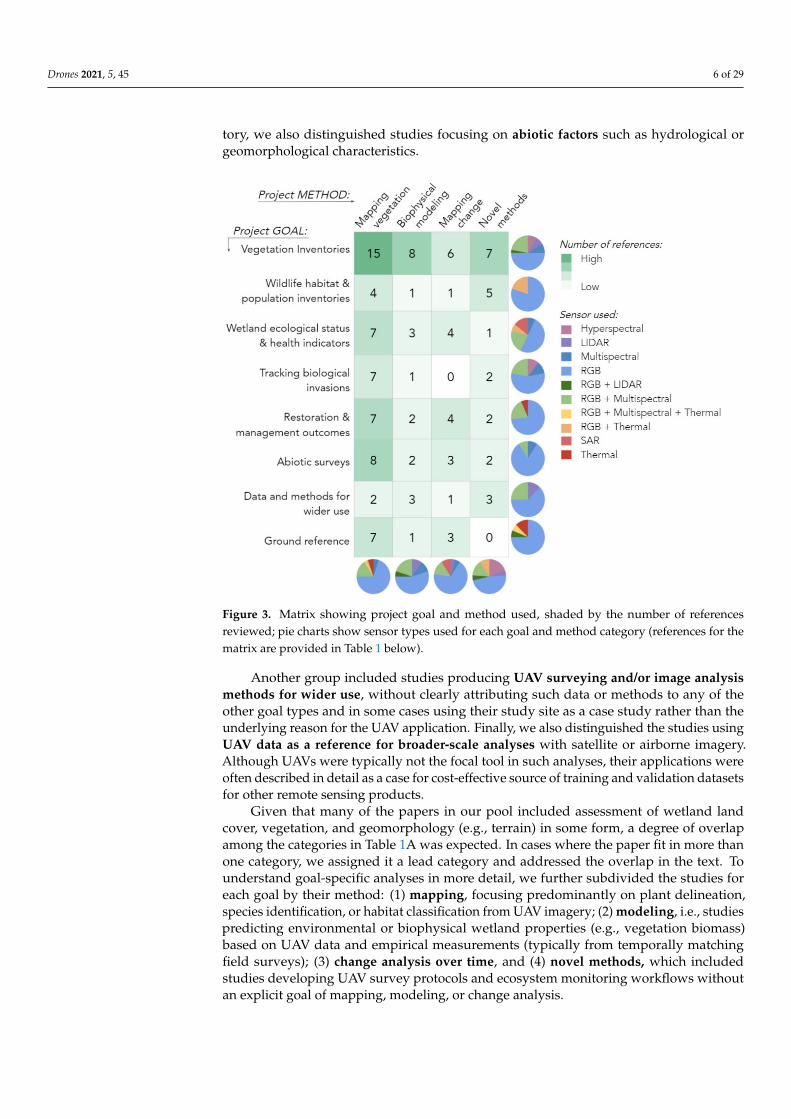
tory, we also distinguished studies focusing on abiotic factors such as hydrological orgeomorphological characteristics.
Figure 3. Matrix showing project goal and method used, shaded by the number of referencesreviewed; pie charts show sensor types used for each goal and method category (references for thematrix are provided in Table 1 below).
Another group included studies producing UAV surveying and/or image analysismethods for wider use, without clearly attributing such data or methods to any of theother goal types and in some cases using their study site as a case study rather than theunderlying reason for the UAV application. Finally, we also distinguished the studies usingUAV data as a reference for broader-scale analyses with satellite or airborne imagery.Although UAVs were typically not the focal tool in such analyses, their applications wereoften described in detail as a case for cost-effective source of training and validation datasetsfor other remote sensing products.
Given that many of the papers in our pool included assessment of wetland landcover, vegetation, and geomorphology (e.g., terrain) in some form, a degree of overlapamong the categories in Table 1A was expected. In cases where the paper fit in more thanone category, we assigned it a lead category and addressed the overlap in the text. Tounderstand goal-specific analyses in more detail, we further subdivided the studies foreach goal by their method: (1) mapping, focusing predominantly on plant delineation,species identification, or habitat classification from UAV imagery; (2) modeling, i.e., studiespredicting environmental or biophysical wetland properties (e.g., vegetation biomass)based on UAV data and empirical measurements (typically from temporally matchingfield surveys); (3) change analysis over time, and (4) novel methods, which includedstudies developing UAV survey protocols and ecosystem monitoring workflows withoutan explicit goal of mapping, modeling, or change analysis.

Drones 2021, 5, 45 7 of 29
Table 1. Distribution of reviewed studies by the primary goal of wetland unoccupied aerial vehicle (UAV) application andprimary method category.
Primary Goal of theUAV Application
Primary Method in the Application
Mapping Vegetationand Land Cover
Modeling BiophysicalParameters ofEcosystem or
Vegetation
Mapping ChangeOver Time
Development ofNovel Methods
Vegetation inventories [24,29,40,41,61,69,70,73,77,80–85]
[23,33,53,54,62,67,86,87] [88–93] [5,14,15,71,79,94,95]
Wildlife habitat andpopulationinventories
[96–99] [36] [100] [63,101–104]
Wetland ecologicalstatus and health
indicators[27,34,42,47,48,64,105] [35,106,107] [108–111] [7]
Tracking biologicalinvasions [25,68,74,112–115] [116] - [13,55]
Restoration andmanagement
outcomes[10,11,56,57,117–119] [120,121] [8,9,43,122] [44,123]
Abiotic surveys [32,45,58,65,124–127] [28,128] [4,129,130] [66,131]Data and methods for
wider use [76,132] [133–135] [78] [6,136,137]
Ground reference [72,75,138–142] [143] [144–146] -
The overall distribution of studies among project goals and methods shows a strongprevalence of vegetation inventory applications, most of which focused on mapping(Figure 3). Similarly, mapping was the leading type of analysis in abiotic inventories,restoration, and management assessments, while studies of wetland ecological health werethe next three most prevalent goals (Figure 3). Interestingly, despite the obvious appeal ofUAVs for monitoring of wetland change analysis, such applications were relatively few,accounting for less than one-third of studies for any of the major goals. Nevertheless, manyassessments of single-date imagery acknowledged the importance of change detection intheir discussion sections, commenting on the utility of monitoring over time. Modeling ofvegetation or ecosystem parameters from UAV data was also less common than mapping;however, our pool included examples of modeling studies for every major goal exceptabiotic factor inventories (Figure 3). A similar number of studies focused on UAV surveyingworkflows and logistics, which were present in almost all goals except the use of UAVs asreference data. Specific applications focusing on these project goals and analysis types arediscussed in subsequent Sections 3.2–3.9.
3.2. Vegetation Inventories
Not surprisingly, vegetation mapping dominated the reviewed literature. Nearly onethird of the papers reviewed (n = 36) focused on the use of UAVs for wetland mapping,modeling, change detection, and novel method development. These inventory studies usedthe largest variety of sensors: RGB, Multispectral, Hyperspectral, LiDAR, and combinationsof these (Figure 3). Thirteen papers focused on case studies mapping wetlands from coarseto fine scales. Rupasinghe et al. [82] and Castellanos-Galindo et al. [80] each highlightedthe use of green vegetation indices (e.g., Visible Atmospherically Resistant Index (VARI)and Green Leaf Index) developed from RGB imagery along with DSM to classify generalshoreline land cover and wetland habitat. Two early examples of UAVs for wetlandmapping [15,61] proved that the spectral and spatial resolution provided by an RGBorthophoto was sufficient to identify key wetland vegetation features. Zweig et al. [40] wereable to use a more automated approach to classify freshwater wetland community types inthe Florida Everglades using an RGB orthophoto, and Morgan et al. [41] reported a similar

Drones 2021, 5, 45 8 of 29
approach mapping riparian wetland community types. Other case studies incorporatedDSM information in classification. For instance, Palace et al. [81] used artificial neuralnetworks (ANN) to classify peatland vegetative cover types in Sweden, while Corti Menseset al. [83] used a novel RGB vegetation index (i.e., excess green and excess red) and thepoint geometry from DSM to classify the density, vitality, and shape of aquatic reed bedsin a lake in southern Germany. One paper [85] incorporated thermal bands with RGB formapping riparian vegetation in the Yongding River Basin in China.
Five papers focused on the use of OBIA to capture multi-scale attributes of wetlandmosaics. OBIA is a frequently used set of techniques to extract individual features fromhigh spatial resolution imagery [147]. The method uses spatial and spectral informationto segment an image into semantically and ecologically meaningful multi-scale objects,which are then classified based on numerous decision rules. Because wetlands can be veryspatially heterogeneous, often displaying multi-scale patterns of vegetation [148,149], theOBIA framework can be very helpful [150]. Four papers embraced an OBIA workflow tomap wetland features. For example, the complex vegetation mosaic found in peatlandsand heathlands were mapped using OBIA techniques applied to RGB orthomosaics byBertacchi et al. [69] and Díaz-Varella et al. [70], respectively. Shang et al. [77] used an OBIAmethod to classify coastal wetland community types in China. Durgan et al. [29] andBroussard et al. [24] included the DSM product in their OBIA classification of floodplainand coastal marsh vegetation, respectively. Both found the OBIA method improvedclassification accuracy, and each report accuracies up to 85%.
Because wetland vegetation exhibit high rates of net primary productivity [151,152],and wetland aboveground biomass is an important indicator of carbon storage, productiv-ity, and health, many papers reviewed and evaluated the use of UAVs for AGB mapping.Several papers reviewed focused on UAV data in estimating aboveground biomass andlinking spatial AGB estimates to models that helped to scale field data to larger land-scapes. Two studies focused on the use of SfM from RGB data [53,87] to estimate biomass.Others linked targeted UAV data with satellite imagery to map biomass, including com-bining NDVI from multispectral UAV imagery and Landsat imagery [33], UAV-LiDARand Sentinel-2 imagery [86], and RGB UAV imagery with Sentinel-1 and Sentinel-2 im-agery [62]. Two studies [54,67] used SfM with RGB imagery to capture detailed modelsof riparian vegetation in order to reconstruct physical models of structure and shadingproperties, while another riverine study [23] used RGB and multispectral orthophotoswith an OBIA approach. They first mapped spectrally similar riparian objects and thenapplied in situ carbon stocks estimations to the objects to estimate the entire riparian forestcarbon reservoir.
Monitoring vegetation dynamics is critical for management, and six papers describedanalysis of multi-date UAV missions. Two studies mapped vegetation change as a re-sponse to an external stressor [88,92] and four mapped seasonal changes at the communitylevel [89–91] or at the species level [93]. Vegetation change was revealed through spectralindices [92,93], via DSMs derived from multispectral cameras [89–91], or LiDAR [88].
The use of UAVs in wetland science is growing, as are novel methods for analyz-ing data. Several papers discussed new uses of sensors common in remote sensingbut less tested with UAVs, such as hyperspectral [94] or LiDAR [95]; or new sensorcombinations [5,71]. These cases suggested that data other than RGB imagery can bepowerful for wetland vegetation mapping. For example, Zhu et al. [71] showed howthe combination of SAR, optical (from the Geofeng-2 satellite (GF-2)) and a DSM from afixed-wing UAV could be used to map mangrove biomass in a plantation in China. Pin-ton et al. [5] developed a new method for correcting the impact of slope on vegetationcharacteristics using UAV-borne LiDAR instrumentation. Other papers discussed the useof Machine Learning algorithms to characterize vegetation. Among those, Cao et al. [14]found support vector machines (SVMs) to be the best classifier of hyperspectral imageryof mangrove species; Li et al. [15] transformed hyperspectral, RGB, and DSM data priorto classification of 13 mangrove species with SVM, and Pashaei et al. [79] evaluated a

Drones 2021, 5, 45 9 of 29
range of convolutional neural network (CNN) architectures to map coastal saltmarsh withRGB imagery. Collectively, these novel applications suggest that the success of vegetationinventories with UAVs can be greatly boosted by joint use of richer datasets and moresophisticated algorithms. Finally, such analyses are becoming increasingly feasible andaccessible to a wider range of users thanks to novel open-source computing tools, suchas Weka software used in [14], free Amazon Web Services cloud computing in [79], andCloudCompare software in [5].
3.3. Wildlife Habitat and Population Inventories
Spatially comprehensive and customizable UAV observations can tremendously sup-port monitoring of wildlife populations and habitats, while greatly reducing the scopeand duration of human presence compared to direct field surveys. This capacity becomesinvaluable in wetlands with massive field access limitations or applications with largenumbers of animal individuals or nesting sites, where field surveys can be severely compro-mised by physical view obstructions and limited vantage points [36,63,101]. At the sametime, the success of UAV-based wildlife applications also heavily rely on the detectability ofsuch targets from the aerial view, which may increase with larger size and conspicuousnessof individual species or their habitat features [63,101].
Most wildlife-related wetland UAV studies in our pool have focused on birds (sevenout of ten papers) with two others considered mammals [100,102] and crustaceans (crab)in relation to illegal trapping [97]. One study assessed a broader suite of coastal habitatswith salt marshes and mudflats among those [104]. Among less directly habitat-focusedstudies, one paper from the wetland health category focused on a rare wetland plant speciesindicator of susceptible deer activity in a wetland with increasing deer population [108],while another application discussed an abiotic transformation of the landscape inducedby American beaver (Castor canadensis) [127]. Most frequently, such analyses targeted:1) animal populations or colonies [36,63,101,103]; 2) habitat components [99–101]; and 3)evidence of wildlife activity on the landscape [96,100,108,127]. The majority of these UAVapplications used RGB cameras or a combination of RGB and thermal sensors (Figure 3).
Inventories of bird colonies are especially well facilitated by UAVs when targetinglarger waterbird species or their nests located on top of plant canopies [36,101,103], boththrough human [101] and automated machine-learning image recognition [36,63]. Wildlifedetection potential can be substantially amplified by the use of thermal cameras thatenhance identification of animals based on the contrast between their body temperaturesand environment [102]. In avian studies, unique thermal properties of nesting material canalso help identify nest features from thermal data even when the birds are not present [101].A “dual-camera” approach combining RGB with thermal sensing is thus highly appealingto animal inventorying applications [101].
Importantly, by their nature, UAV observations of wildlife can often be a form ofdisturbance and, as such, require a particular level of procedural control and elevateddegree of supervision during flights. This issue was manifested in bird inventories as animportant tradeoff between enhanced spatial detail and increased disturbance to nestingcolonies with lower flight altitudes [101,103]. While assessing and avoiding the degree ofanimal disturbance during UAV observations is a recommended practice [63,101], estab-lishing a specific relationship between altitude and disturbance may not always be feasible.Instead, other proxies can be used such as the number of birds leaving the nests during thesurvey [101].
UAV-induced disturbance becomes less concerning in studies focusing on detectinghabitat elements [99,104] or impacts of wildlife activity on wetland landscapes [96,108],where flights can be conducted outside of the primary breeding and nesting seasons.Specific uses of UAV data in such habitat-oriented assessments are versatile, including bothvisual assessments of recognizable features, such as beaver dams [100] and classificationsof UAV imagery into habitat features of specific relevance to species, such as tussocksin [99], or mudflats, oyster reefs, and salt marshes in [104]. Notably, modifications of the

Drones 2021, 5, 45 10 of 29
landscape by wildlife can be seen both as an indicators of conservation success, e.g., whensignifying the outcome of reintroduction [100], and as a disturbance and ecosystem changedrivers, e.g., in cases of grazing and trampling [96,108]. Given the indirect nature of suchevidence, UAV surveys should ideally be accompanied or validated with other assessments,such as in situ camera traps, to provide local nuances on animal movement and habitatuse for more robust and comprehensive conclusions about wildlife population status andactivity [108].
3.4. Wetland Ecological Status and Health Indicators
Wetland monitoring at the whole-site and regional scale often aims to make diagnosticassessments of ecological status and health and, ideally, to detect early warning signals ofdegradation, decline, or disturbance that may lead to irreversible long-term disruptionssuch as losses of water quality, critical habitat, or similar issues [34,47,138,144]. Emergingapplications of UAVs are extremely promising for informing cost-effective yet spatiallycomprehensive indicators of wetland health at the landscape scale and support long-termmonitoring needs. Our pool of studies in this category included seven mapping, threemodeling, three change analysis, and one novel method application that either targeted aparticular aspect of wetland ecological health such as water quality (e.g., [105]) and vegeta-tion indicators (e.g., [42,108,111]) or assessed the overall ecological status using differentindicators (e.g., [7,34]). These studies employed RGB, Multispectral, Hyperspectral, andSAR sensors, as well as combinations of RGB and Multispectral and RGB and Thermal sen-sors (Figure 3). Multi-sensor combinations especially benefit holistic assessments targetingmultiple health indicators by helping to strategically optimize surveying workload betweenless demanding and easily replicable tasks (such as visual recognition from passive RGBimagery) and more intensive data processing endeavors (such as LiDAR-derived modelingof geomorphology and vegetation structure) [7,34,35].
A common, notable characteristic among these studies was the focus on disturbanceand stress factors leaving a sizable fingerprint on wetland ecosystems that can be de-tected with the help of UAVs more comprehensively and cost-effectively than with fieldsurveys [34,111]. Certain assessments are almost uniquely made possible by the customiz-able aspects of UAV surveying, such as monitoring wetland body volumes and waterbudgets based on the 3D information enabled by image overlap [107]. At the same time,a relatively novel history of such applications clearly shows the need for comparativeassessments, equipment use trials, and field verifications to optimize workflows for agiven set of objectives. For instance, Cândido et al. [105] tested multiple spectral indicesof water quality derived from RGB information, which can be computed from a widearray of camera sensors. A comprehensive coastal ecosystem assessment in [34] useddifferent instrument types and altitudes for different indicators. For example, they usedRGB cameras at lower altitudes for monitoring pollution, littering, and shoreline position,and employed a thermal sensor at higher altitudes to detect the structure of wetlands andsignals of vegetation decay. Vegetation-based indicators play an especially prominent rolein such assessments, including the presence of characteristic [27,35,42,48,106] or specialstatus [64,108] native plant species or signals of vegetation mortality and stress [27,34,42].Among abiotic indicators, several geomorphological and hydrological characteristics canbe informed by UAV data, including shoreline microtopography and slope gradients, waterquality, surface roughness, and evidence of anthropogenic impacts [7,34,35,47,107].
Interestingly, only a small fraction of such studies focused on wetland change usingUAV data from more than one time frame [108–111]. Two studies focusing on coastal wet-land change and signals of marsh dieback in Southeastern USA [109,110] performed changeanalysis using UAVSAR data provided and managed by the U.S. National Aeronautics andSpace Administration (NASA). Another change study in this category [108] tracked thespatial distribution of an endangered native plant species in a wetland with expandingdeer population and increasing vegetation disturbance. Finally, the study of a characteristicdisturbance-sensitive wet floodplain plant species highlighted the importance of inter-

Drones 2021, 5, 45 11 of 29
annual fluctuations in patch dynamics in response to various landscape stressors evenin sustainable populations [111]. Together, these studies highlight an important twofoldvalue of multi-temporal UAV information: 1) the ability to more accurately assess site-scalechanges in species coverage than with field surveys, particularly for rare species that maybe missed by discrete plots, and 2) the capacity to cover the time span commensurate withthe scale of the processes and detectable impact, which is critical for unveiling mechanisticdrivers of change.
3.5. Tracking Biological Invasions
Invasive plants are some of the most widespread biological threats to wetland environ-ments, causing rapid ecological and economic damage throughout these biomes [13,25,116].In our review, there were nine studies involving invasive plant identification, consistingof six mapping, one modeling, and two novel method papers (Figure 3). Issues causedby invasive species involve reduced habitat for native populations [74,112,113], modifiednutrient cycling [113], and negative impacts on livestock [55,116]. Although some inva-sive aquatic species have beneficial traits, such as increased carbon capture and food forfish [55], aquatic managers typically aim to remove these species from the environment.Management goals pertaining to invasive species largely involve plant identification andremediation, and UAVs allow for on-the-ground immediate assessment and response.Specific objectives for these studies include plant identification [55,68,74,112], biomassand plant height estimates [116], and herbicide application assessments [116]. Invasiveplants that are often targeted for removal include species such as wild rice (Zizania latifo-lia) [116], hogweed (Heracleum mantegazzianum), Himalayan balsam (Impatiens glandulifera),Japanese knotweed (Fallopia japonica and F. sachalinensis) [25], sea couch grass (Elymusathericus) [55], blueberry hybrids (Vaccinium corymbosum x angustifolium) [114], saltmarshcordgrass (Spartina alterniflora) [74], water hyacinth (Eichornia crassipes), water primrose(Ludwigia spp.) [13], glossy buckthorn (Frangula alnus) [115], and common reed (Phragmitessp.) [68,112,115], which is one of the most “problematic invasive species in wetlands inNorth America” [113].
Aerial imagery is a useful tool in the management of invasives, and aerial photographyhas been employed for this purpose since the beginning of the twentieth century [153].UAVs have expanded the spatial and temporal capabilities of vegetation mapping, andthis increased resolution allows for more fine-scale detection of individual species [55].Spectral indices such as the normalized difference vegetation index (NDVI) [55,112] andthe normalized difference water index (NDWI) [55] are common for invasive speciesdetection, while texture-based analysis [68], deep learning [114], and object-based imageanalysis (OBIA) are successful methods used for invasive species classification [55,74].As many of the UAV-based invasive species studies, we reviewed used RGB (n = 7) andmultispectral (n = 3) imagery, orthophotos [25,74,112], and digital surface models [55,116]were common data products. To overcome spectral limitations of such data, some studiesdeveloped sophisticated mapping approaches using Machine Learning algorithms; forexample, Cohen and Lewis [115] proposed a monitoring system for two common invasiveplants in the Great Lakes coastal ecosystems with the CNN-based software for automatedrecognition of these species. A more recent study demonstrates that imaging spectroscopythrough aerial hyperspectral sensors can increase vegetation classification accuracy [13].While mapping invasive plants is relatively easy to learn and produces sharable outputswith managers and stakeholders [116], limitations of this method include difficultiesidentifying submerged or emergent aquatic plants due to visibility issues from turbid waterand solar reflection on the water’s surface [154]. With reduced sensor costs and increaseddata storage capacity, hyperspectral sensors on UAVs will pave the way for more accurateidentification of invasive species [13].

Drones 2021, 5, 45 12 of 29
3.6. Restoration and Management Outcomes
Restoration projects provide ecosystem services such as habitat for aquatic flora andfauna, improved water quality and quantity [120], and increased carbon storage [56]. In ourreview, we found fifteen papers that focused on restoration goals, involving seven mapping,two modeling, four change over time, and two novel method studies (Figure 3). Althoughrestoration monitoring is a vital component of ecological management, it is rarely priori-tized due to time and personnel constraints associated with ground surveys, lags betweenproject implementation and data analysis, and the need for high-resolution data [26,120].UAVs are tools that enable restoration assessment at the whole-site levels and allow forcost-effective change analysis of restored environments [8,9,121,122] due to their flexibil-ity in flight times and heights and lack of disturbance to sensitive restoration areas [56].Furthermore, repeat aerial surveys facilitate adaptive management techniques [118] of iter-atively examining and modifying projects, and this continual decision-making capabilityhelps ensure long-term success of restoration projects.
UAV-based restoration monitoring involves a variety of objectives, including biomassestimates [120], hydrological mapping [8,9,11,123], morphological evaluations [43,57], and clas-sification of plant communities in peatlands [10,56,119,122] and coastal regions [44,117,118,121].While many researchers leverage RGB aerial imagery for restoration monitoring [8,9,120,122,123],multispectral imagery, and specifically the near-infrared wavelength, which can detectspecies and topography in shallow wetland environments [155]. This is particularly use-ful in invasive species identification [121] and peatland biodiversity assessments [56] atrestoration sites. Additionally, thermal aerial imagery can be used to locate groundwaterdischarge in restored peatlands, greatly reducing time spent conducting ground-basedseep detection studies [11]. Vertical takeoff and landing in constricted or topographically-complex areas generates popularity of quadcopter UAV usage for small restoration studyregions [8–11,120,122], while fixed-wing UAVs are preferred when mapping larger restora-tion projects [56,118,121,123]. UAVs prove to be efficient tools to track human-inducedecological modifications [9,11,44,118,122,123], and cheaper and lighter multispectral sen-sors for quadcopter, and fixed-wing UAVs will help advance future restoration assessmentsand analysis.
3.7. Abiotic Surveys
The mapping and modeling of abiotic environmental features such as land coverclasses [4,58,65,124,129] and water [32,45,66,127,131] are important for understandingsurface dynamics and how landscapes evolve, which complements the multitude of UAVwetland vegetation studies by providing information on the structure and habitat ofthese species. We reviewed fifteen papers pertaining to abiotic surveys, which was thesecond largest number of papers in one category, following the vegetation inventory group(Figure 3). A common theme in abiotic mapping and change detection is SfM analysisderived from RGB imagery [4,58,127,129]. In these studies, point clouds are generated toconstruct digital surface models that estimate volumetric compositions of the landscape,similar to LiDAR data [4,58]. This is a useful technique in abiotic UAV research that pertainsto modeling shoreline losses and habitat destruction [4,130], floodplain connectivity [127],carbon storage estimates [129], and topobathymetry [58,128]. Real-time kinematic (RTK)GPS can greatly enhance the precision of such studies [4,5,45,58,65,124,131] and groundcontrol points (GCPs) [4,45,58,65,66,124,129] can generate greater horizontal and verticalaccuracy in landscape modeling and change detection studies. In particular, Correll andcolleagues [28] rigorously employed RTK to measure elevation in a tidal marsh. Theirstudy reported that raw UAS data “do not” work well for predicting ground-level elevationof tidal marshes, likely because a DSM is not equivalent to a DEM [28]. Other projects inthe realm of abiotic mapping involve RGB analysis of soil structure and infiltration [131],delineations of riparian zones [125], and saltmarsh shoreline deposition [126], in addition tothermal analysis of river to floodplain connectivity [127], river temperature heterogeneityin fish habitats [45], and peatland groundwater seepage detection [32].

Drones 2021, 5, 45 13 of 29
UAVs are particularly important in abiotic mapping and modeling studies because thehydrodynamic complexity and tidal fluxes characteristic to many of these environmentscan leave little time for ground surveys [58] and sites like blanket bogs are often difficult toaccess because they are remote [129]. UAVs are therefore helpful in these studies becausethey reduce the cost of ground surveys and in situ sensor deployment [4,66], can accessregions that are difficult to reach [58], and are relatively easy to deploy and use [129]. UAVsare successful in achieving abiotic management goals of reduced erosion [4,124], floodmonitoring [58], and carbon and peatland conservation [129]. Future abiotic mappingand modeling techniques will benefit from increased UAV and in situ paired samplingmethods, as demonstrated by Pinton et al. [66] who used dye tracing coupled with RGBimagery to measure saltmarsh surface velocities and Isokangas et al. [32] who used stableisotopes paired with RGB, multispectral, and thermal imaging to evaluate peatland waterpurifying processes.
3.8. Data and Methods for Wider Use
Applications of UAVs as a source of reference information demonstrate their specialpotential to support broader-scale analyses from satellite and other (piloted) aerial im-agery [72,75,138–146]. Our pool included 12 papers in this category, mostly using RGBbut also RGB + Thermal, RGB + Multi + Thermal, and Thermal instruments (Figure 3).Most commonly, such applications use UAV images to infer the identity and location ofwetland land cover and vegetation types [72,138–140,142], sometimes up to individualplant species level [146] to generate training and/or validation samples for landscape-scalewetland classifications. Assignment of reference categories can range from manual delin-eation of specific class extents or smaller samples based on their visual recognition fromthe ‘raw’ UAV imagery [139,140] to more automated classifications using computer-basedalgorithms [72,138]. High spatial detail and recognizability of landscape features fromUAVs increases the analyst’s confidence in selection of such samples compared to, e.g.,coarser-resolution imagery, while whole-site coverage allows obtaining a much largernumber of samples compared to field surveys given site access constraints [29,139,146]. Inaddition to hard classifications, UAV-derived high-resolution maps can also support fuzzyanalyses from coarser-resolution data, such as spectral unmixing of pixels into fractions ofcontributing cover types, both as a source of “endmember” examples [138] and as a basisfor validating endmember fractions estimated from satellite imagery [75,138].
Reference information from UAVs can include not only thematic identities of wetlandsurface components but also their quantitative properties that can be assessed visually [141,143] or via statistical summary of the mapped imagery [145]. For example, a study of aninvasive wetland grass [143] relied on visual interpretation of its percent cover from imageportions matching the field survey plots, while a study of mangrove ecosystems [141]took advantage of high spatial detail in UAVs to identify areas of different tree density tocalibrate the analyses based on satellite data. Similarly, a study focusing on a forested bogin Czech Republic [135] developed a UAV-based workflow for tree inventories based on theUAV-derived CHMs. Such applications also highlight important opportunities for regionalup-scaling of ecosystem properties with remote sensing indicators using models derivedfrom UAV data [145], since the latter can be more accurately matched with fine-scaleground measurements in both space and time than from satellite image pixels.
Finally, in some applications, UAVs were used to complement other satellite, pilotedaerial, and historical geospatial data sources by helping to characterize landscape qualities,composition, and status from a unique spatial perspective not possible with these othersources [144,146]. For instance, a historical analysis of a river floodplain change [144] foundUAV orthoimagery and DEM valuable for measuring terrain geomorphology, vegetationdistribution as well as signatures of human land use to complement the analyses withhistorical maps and satellite imagery (Landsat and Sentinel-2). In such applications, UAVdatasets can both fill a gap in historical image series by complementing piloted aerialphotography archives, and elucidate certain landscape characteristics at a great level

Drones 2021, 5, 45 14 of 29
of interpretation fidelity, especially within regions unreachable by field surveys [144].Notably, the informative richness offered by very high UAV resolution can be significanteven in studies working with already fairly high spatial resolution of 1–4 meters, such asPleiades [138], RapidEye, and Worldview satellites [140]; Spot-6 at 1.5 m [141]; or USAnational aerial imagery products [146], in addition to medium-resolution products such asLandsat and Sentinel-2 [72,75,139].
At the same time, several important technical factors have been mentioned as potentiallimitations in these applications, such as mismatches between spectral values of UAV andsatellite products for a given electromagnetic band or index and limitations of recognition atfine semantic levels [138,139,146]. It may also be difficult to derive automated classificationsof spectrally rich and heterogeneous UAV data for mapping reference classes, particularlywith a limited number of spectral bands, which may lead to manual corrections of classifiedmaps or even hand digitization of the key land cover types from the raw data [75,146].Finally, in a number of cases, UAV-derived field information may not be sufficient or mayrequire additional validation with field surveys and ground-level photographs of samplinglocations [139,146]. Addressing these challenges may be possible by performing flightsat different stages of the plant growing season or hydrological cycle [139,146] to captureunique phenological aspects of classes. Spectrally limited UAV data may be strategicallyapplied to workflow steps where they are likely to be most useful, e.g., for a fine-scalemapping of easily distinguishable classes, to facilitate more detailed classifications withinthese categories from other sources [146].
3.9. Ground Reference Applications
A smaller group of studies (n = 8) in our pool applied UAVs towards developinggeneralizable methodologies for image processing, information extraction, and/or fieldsurveying [6,76,78,132–134,136,137] using RGB, RGB and Multispectral, and LiDAR sensors(Figure 3). Such studies often emphasized methodology-building efforts more than site-specific ecological questions and discussed the relevance of the proposed analyses andworkflows to wetland management, conservation, or research beyond their specific casestudy sites. Four of these applications focused on UAV data processing for mapping andquantitative assessments of vegetation [76,133,134] and hydrological properties [132], whilefour other studies concentrated primarily on UAV surveying workflows [6,136,137], withone study proposing a full workflow for both surveying and subsequent image processingfor riverine and estuarine landscape change assessment [78].
Overall, despite the small size of this literature pool, the versatility of its topicshighlights the importance of this emerging methodology-developing trend for a widearray of wetland management and monitoring needs. Furthermore, it is obvious thatsome of these needs can be uniquely facilitated by the special nature of UAV data andsurveying protocols. For instance, methodology to generate multi-angular landscapeimages from overlapping UAV image tiles showed a strong potential to improve object-based classification of complex landscapes at land-water ecotones [76] and a powerfulstrategy to overcome the limitations of low spectral richness in RGB orthoimagery mosaics.Among non-vegetation applications, a method to map groundwater table in peatlandsproposed by Rahman et al. [132] relies on UAV-derived orthophotographs to detect surfacewater bodies and on photogrammetric point clouds to extract landscape samples of waterelevation, which together enable a continuous interpolation of groundwater levels across abroader landscape. Similarly, the UAV-borne LiDAR surveying workflow together witha customized software system developed by Guo et al. [133] holds a strong promise toalleviate the challenge of characterizing 3D vegetation structure as critical determinant ofhabitat and ecosystem function in complex, limited-access sites such as mangrove forests.Another example of vegetation structure modeling involved prediction of mangrove leafarea index (LAI) based on different NDVI measures computed from UAV and satellitedata [134]. Notably, in the latter study, UAV indices tended to correlate with field-measuredLAI less strongly than satellite-based ones, except a well-performing “scaled” UAV-based

Drones 2021, 5, 45 15 of 29
form of NDVI which included adjustments for the greenness of pure vegetation andpure non-vegetated background. Not surprisingly, the role field-collected validation datasuch as direct vegetation measurements [133,134] in or groundwater well data [132] wasimportant in these studies even though it was not always required for the ultimate use ofthe developed methods.
In turn, studies prioritizing the development of field survey workflows were oftenmotivated by the need to generate data and methods serving potentially different usersand management questions [6,78,136,137]. Examples of mentioned ongoing or potentialwetland applications supported by UAV data included monitoring changes in aquatic andemergent habitats and landscape structure [6,78,137], tracking invasive and native plantspecies [137], delineating different types of wetlands for wetland management [137], andgeomorphological assessments [78], involving very practical purposes such as decisionson wetland reclamation [136]. Not surprisingly, both orthoimagery and SfM play criticalroles in the anticipated data uses and receive close attention in field surveying workflows.Another notable consideration for UAV surveying workflows discussed by Thamm et al. [6]involved ground truthing specifically of satellite-based SAR products, which can be difficultto interpret visually due to the nature of this active remote sensing, but which are criticalin humid, cloudy regions such as their study area in Tanzania.
Versatility of potential data uses from such efforts also raises important considerationsabout the optimal timing of data collection, including multi-seasonal acquisitions [6,137],as well as practical measures to maximize the efficiency of time in the field to optimize themonitoring routines [6]. The latter issue may also require innovative strategies around UAVinstrumentation: for instance, Kim et al. [136] discussed the advantages of a fixed/rotaryhybrid UAV system to meet multiple challenges of coastal assessment including the largesurvey area requiring longer flights, high wind requiring resistance, and the ability tohover, among other features. Relatedly, development of surveying workflows for universalwetland management uses needs to pay close attention to positioning error and both hori-zontal and vertical accuracy [78,136], and understand which levels of error are acceptablefor specific applications [136].
4. Discussion4.1. Technological Opportunities and Strenghts in Wetland Applications of UAVs
Several important strengths of the expanding UAV technology are evident across thepool of wetland applications reviewed in this synthesis. First, UAVs provide spatially-comprehensive coverage that enable researchers and managers to view the wetland as anentire entity. This large spatial extent differs from field surveys that capture discrete ratherthan continuous data at smaller spatial and temporal resolutions, although certain types ofdata necessarily must come from ground observations, such as soil samples [117,131]. Highresolution imagery from a UAV enables a high degree of visual recognition, providing anarray of opportunities from basic surveying (e.g., plant cover, vegetation types with distinctmorphological properties, visual texture and color) [55,63,68,81] to mapping, modeling,and quantifying wetland characteristics. Also, the customizable timing of UAV flightsallows for users to avoid cloud issues, which are prevalent in wetland environments [156],and track wetland vegetation phenology, which is critical at early stages after disturbancesand restoration. UAV customization permits users to choose their sensor of choice (i.e.,RGB, multispectral, LiDAR, thermal, hyperspectral) that can be adapted to the study’sobjective, whether it pertains to the morphological changes of a saltmarsh environment orto the aboveground biomass estimations in a mangrove ecosystem. User-defined flights arealso advantageous in wetland studies because they enable repeat missions (e.g., [92,93]) atvarious flying heights (some even over 400 m above ground level) (e.g., [35,71,74]), whichcreate various corresponding ground sampling distances used to address the researchquestion at hand. Finally, UAVs are highly beneficial in wetland environments becausethey help overcome challenges of site access [157], and provide cost-effective alternativesto traditional surveying methods that require ample labor and time [53].

Drones 2021, 5, 45 16 of 29
4.2. Field Operations in Wetland Setting
Several important considerations may affect feasibility of flight surveys even whenUAVs of desirable type are available to achieve a given management goal. Regulations onUAV surveying often affect spatial scope, timing, and feasibility of wetland surveys [25,40],and may differ among countries as discussed by earlier reviews [37,158,159]. Not surpris-ingly, previous efforts (e.g., [3,136]) highlight regulations as one necessary improvement tomake UAVs more ubiquitous in science applications. For example, reduced restrictions onlighter remote-piloted aircraft operations in Australia were mentioned as an important wayto facilitate novel ecological research [53,160]. A study performed in the Czech Republiccited drone traffic restrictions as a limiting factor in the flight altitude [8]. In the USA,multiple regulations have been developed for various aspects of field UAV operations,including field crew size, flying altitudes, proximity to airports, and other considerations(see, for example, summaries of key regulations by the Federal Aviation Administration(FAA) in Zweig et al. [40] and Jeziorska [37]). A riparian study in the UK [54] mentionedUAV flight regulations as a reason for dividing the study area into sections and acquiringtheir images separately. In addition to common protocols related to weather, airspaceregulations, and proximity to specific land uses [24,40], wetlands may invoke additionalregulatory constraints due to presence of sensitive species and habitats [101]. For instance,wildlife inventories may often require permitting for both field surveys of animal popula-tions and on-site UAV use and may demand that researchers and managers formally assessand minimize the disturbance during field sessions [63,101,103]. Such restrictions not onlycan become direct obstacles to data collection in certain contexts [5,24], but also affect userperceptions about the adoption of UAVs as a monitoring tool [161].
The dynamic and heterogeneous environmental setting of wetlands creates multiplechallenges for both spatial scope and timing of UAV applications. Site entry issues pro-hibitive for field surveys may also significantly reduce access for efficient UAV operationdue to lack of suitable landing and launching sites [24,144] and low mobile network cover-age prohibiting real-time georeferencing [25,27]. A vivid example of these challenges wasnoted by [24], where the use of an airboat was necessary to maintain radio communicationwhen directing the instrument to a landing location due to the lack of suitable sites closeto the target wetland area. Special constraints arise around the establishment and mainte-nance of ground control points (GCPs), since wetland environments significantly limit thecapacity to make GCPs “permanent” and to keep them static given wind, flooding, andmovement of sediment [35,99,104,116,124,126]. Not surprisingly, studies often relied on asmall number of GCPs (median number of GCPs among reporting studies was ~11 per site)and develop various temporary solutions to facilitate ground referencing. For example,Howell et al. [116] used inflatable party balloons for a study of wetland plant biomass;however, strong winds could cause the balloons to deflate or shift, reducing the precisionof their positioning. Similarly, the discussion of georeferencing in avian colony invento-ries [101] proposed buoys as reference features to support image mosaicking in submergedareas near nesting sites. Finally, it may be necessary to avoid site disturbance during GCPinstallation and upkeep; for instance, one application [5,66] deployed GCPs on metal polesby boat during the high tide to both ensure their elevation above the water and reducethe impact on marsh vegetation. As real-time positioning technologies such as RTK arebecoming more accessible, the labor-intensive task of GCP placement and maintenancemay become less relevant over time (e.g., [7,28,131,144]).
More generally, studies showed a substantial variation in reporting positional accura-cies and errors both for image mosaicking and for the field georeferencing. Approximatelyhalf of the studies (56 papers) mentioned using GCPs and 49 of them provided someinformation on the number of points, and even fewer (~40 studies) made comments aboutGCP positional accuracy. Only 55 studies (~46% of the pool) reported some form of surveyand image mosaicking error. Since implications of mosaicking and positioning errorsare likely to substantially vary among management goals (e.g., [28,119,128,133]), the lackof clear accuracy benchmarks as well as standards for accuracy and error reporting in

Drones 2021, 5, 45 17 of 29
UAV applications presents an important action item for the wetland UAV community inthe future.
The timing of UAV operations may be significantly constrained by weather conditionsand airspace restrictions, which may limit the number of flights in a given field sessionand affect data collection consistency across different sites [25,27,104]. Such impacts areespecially strong in coastal tidal wetlands where a targeted phase in the seasonal ecosystemcycle (e.g., plant biomass) must be monitored at a low tide stage and with the appropriatefield conditions, such as low wind speed for operational safety and high solar elevation forminimizing shadows [25,28,65]. Difficulties to recover the UAV instrument from a wetlandin the case of malfunction or failure place a special importance on UAV flight time, battery,data storage capacity, and other factors affecting flight duration and the success of land-ing [24,144], and underscore the need for efficient use of time and logistical resources [6].Prioritizing shorter operation times is also critical for reducing UAV disturbance to wetlandwildlife and exposure of human operators to potential field hazards. An added benefitfrom this perspective is selecting easily replaceable instruments (i.e., different camera andsensor types compatible with the same carrier platform) to assess multiple indicators andmeet various application goals concurrently [133].
4.3. Considerations in UAV Data Processing and Management
Several important aspects of UAV data processing can also be challenged by wetlandenvironments and thus need to be considered early in application workflows. For instance,three-dimensional spatial accuracy in UAV-derived products is dictated both by the fieldoperational factors (e.g., positioning system in the instrument, precision of GCPs, and otherreference locations) and data post-processing (e.g., additional geo-rectification to correctfor spatial shifts in image mosaics [119]). Positional inaccuracies may accumulate andpropagate across workflows, eroding the quality and reliability of the final products [162].Such concerns are especially problematic in studies heavily relying on 3D information,such as assessments of site elevation change in response to restoration treatments or sealevel rise [28,35,43,57,88,118,130].
Reported georeferencing and positioning challenges make it obvious that spatialaccuracies around ~0.1-1m, which are common, for example, in ground-truthing for satellitedata analyses, become too coarse relative to very small (<0.1m) pixel sizes possible withmodern UAVs. Simultaneously, the dynamic nature of wetland environments inherentlyimposes a fundamental degree of positional uncertainty due to wind-induced movementof vegetation, fluctuations in water extent, and changes in mudflat, sediment, and grounddebris. Effectively, this means that even very high levels of positional accuracy may notalways guarantee the “true” match between wetland surface elements and the spatiallocation of a given small pixel. This issue has not been extensively discussed; however, itraises an important need to better understand what minimum spatial resolution is likelyto realistically represent landscape features in a given wetland setting and what spatialerrors are acceptable in aligning the imagery with field reference locations. This also raisesa question of how much spatial accuracy is really necessary for a given study objective andwhat levels of error may lead to similar analysis outcomes without substantially impactingthe quality of inference from UAV data.
Very high spatial detail in UAV imagery can also become a massive challenge for auto-mated computer-based algorithms in mapping and change detection [25,27,72,75,78]. Smallpixel size amplifies wetland spectral heterogeneity by highlighting local variability in illumi-nation, shadows, vegetation stress, background flooding, and similar factors. This may de-crease the ability to successfully distinguish landscape classes [42,139,141], especially fromspectrally limited RGB imagery [75,76,104]. Although multiple techniques to navigate thesechallenges have been proposed, such as image texture measures summarizing local het-erogeneity at the pixel or local moving window scales and OBIA tools [29,55,69,76,78,104],their use among wetland UAV studies remains somewhat limited and calls for more guid-ing recommendations. Image texture metrics were used with mixed success in the reviewed

Drones 2021, 5, 45 18 of 29
studies and showed strong sensitivity to spectral artifacts caused by topographic breaks,orthomosaicking distortions, and similar factors [27,55,68,140,143]. For OBIA, similar toprevious applications of satellite and piloted aerial imagery [150], studies reported chal-lenges in choosing among different options for segmentation parameters [25,27,78], as wellas disagreements among different classification algorithms [29], sometimes causing theanalysts to resort to fully manual delineation [75]. Such mapping limitations can be aggra-vated by challenges to accuracy assessment, such as the lack of standardized assessmentprotocols [24], variability in accuracy among different seasons [145], and the implicationsof human error in field visits for accuracy assessment in UAV images [68].
A notable challenge for wetland management that remains is the limited guidance ondeveloping efficient long-term monitoring plans. Among the papers that frame their workas specifically relevant to monitoring, the actual published case study was often limited tosingle-date analysis. As a result, there are few insights into potential opportunities andchallenges of change analysis with data from UAVs. Potential opportunities include theability to capture fine-scale changes in wetland plant communities at relevant temporalscales. Relevant challenges are introduced with multi-temporal fine-scale imagery becauseimagery can be susceptible to environmental conditions at the time of data acquisition,requiring radiometric calibration between images or normalization between multi-dateDSMs. Some studies circumvented this need by performing a visual photointerpretation atdifferent time frames within a signal wetland site (e.g., [108]); however, this can becomea demanding task for larger wetland regions or multiple time frames. However, none ofthe papers investigating change mentioned radiometric calibration, and only nine papersoverall discussed radiometric calibration [14,23,29,55,56,62,65,71,91]. Although in single-date and single-site applications, radiometric calibration can be automatically facilitated byrelevant software packages and mosaicking tools, longer-term and regional applicationswould require a systematic inter-calibration for discrete mosaics created for isolated sitesor different image dates [24,138].
Finally, while several papers discussed the need to perform reproducible scientificstudies and acknowledged the need for data sharing, only nine studies had some mentionof data accessibility (i.e., data and/or scripts), and only two [36,139] explicitly providedlinks to an accessible repository (e.g., Github, ArcGIS Online). A few others mentionedthat data were available upon request, or were available at a third-party collection. Forexample, two papers by Ramsey et al. [109,110] used NASA’s UAVSAR data, which arecollected, processed, and hosted by NASA for wider use by other parties.
4.4. Perspectives for UAV Use in Long-Term Wetland Monitoring
The collective experience offered by the reviewed applications suggests several in-sights for optimizing the use of UAV workflows for wetland management needs. Overall,the UAVs hold a strong appeal for replacing human observers on the ground [9,31,57]and fill an important information gap between limited-scope field surveys and non-customizable satellite observations [53,138]. At the same time, it is obvious that a fullreplacement of human potential is not yet possible, nor is it necessarily desirable. Manywetland applications require some amount of field data collection [138,140], such as mea-surements of vegetation biomass, height, and other parameters used in modeling efforts(e.g., [62,87,116,133,134]), as well as characteristics of soil and water chemical propertiesthat cannot be observed from the above-ground aerial platforms [105,117,131]. Second,certain targets, such as rare, endangered or problematic plant species, may be too fine-scalein their spatial distribution even for small UAV pixels and thus require field verifica-tion [35,55,108].
These issues highlight an important need to better understand the sufficiency ofUAV-enabled opportunities for a given management goal and strategically apply this un-derstanding to maximize both cost-effectiveness and informative value of data acquisitions.Given common budget limitations, the tradeoff between growing sophistication of rapidlyadvancing UAV instruments and high-risk wetland environmental setting may favor robust

Drones 2021, 5, 45 19 of 29
and, ideally, less expensive sensors and workflows. Furthermore, developing or investingin a long-term monitoring approach using UAVs is complicated by the fact that the tech-nology is changing rapidly and/or the cost of hardware and software is falling quickly.Beyond the instrument expenses, however, wetland applications inevitably necessitateother costs, such as training and labor of personnel, post-flight data processing and man-agement, travel to and from the sites, field logistics, and GCP management [5,24,29,116],all of which can be probed for improving workflow efficiency.
On the field operations side, a critical precursor of such efficiency lies in navigatingthe tradeoff among spatial coverage and timing of operations and informative content ofthe data. For a given camera field of view, reducing flight altitude can increase the flighttime of a study site, but also spatial resolution [34,65,67,69,115,133]. Similarly, expandingthe overlap among images at a given altitude may improve the quality of photogrammetricproducts such as DSMs [57,95], but escalate both the time of data collection and post-processing computational workload [13,65]. For these reasons, efforts pursuing complex,multi-faceted monitoring indicators may especially benefit from multiple flights and/orinstruments with different specifications [7,34].
Importantly, however, a number of wetland applications might be severely con-strained by the insufficiently low flight altitudes, limiting the ability to recognize specificlandscape features or perform visual assessments of water coverage and similar indica-tors [34,43,69,97,106,115]. Among the few studies operating at ≤20m altitudes in our pool,Bertacchi et al. [69] concluded that the most accurate taxonomic identification of plantsat the species/genus level was possible only with the images taken from 5 m altitude,compared to 10 and 25 m tested in the same study, especially for smaller species withmore cryptic distribution. Cohen and Lewis [115] found 20 m to be superior comparedto 30 and 60 m for detecting and mapping density of somewhat more conspicuous in-vasive shrub and reed plant species. Some applications may necessitate extremely low,near-surface surveying—for example, monitoring of a coastal marsh breach in Ponteeand Serato [43] had to fly UAVs “as near low water as was possible” to observe rapidchanges in water volume, and even this strategy could not fully resolve some of the viewchallenges. This evidence suggests that near-surface observations at very low altitudescould provide extremely useful surrogates for ground-level photographs and some otherdata collected by field surveyors [139]. Besides regulatory constraints such as the risk ofwildlife disturbance [101,103], limitations on flying heights were not always clearly stated,and could stem, for example, from practical considerations related to battery life andefficient time use [115], or the intent to optimize the total number of photos [100]. In somecontexts, altitude choices were also driven by characteristics of plant cover and observationgoals; for instance, to enable photogrammetric modeling of tree biomass from UAV data,Navarro et al. [62] used 25 m altitude in a mangrove plantation with trees 0.35–3.4 m inheight to facilitate their crown observations from different view angles. Overall, suchconsiderations clearly highlight the need to better understand the implications of flyingheight limitations for both the data quality and efficiency of post-processing and developmore specific guidelines for different management goals.
It is also critical to anticipate and minimize the effects of potential field survey short-comings on data post-processing and information extraction. For example, sharpness andexposure in visible and thermal camera settings may strongly affect the quality of imagesand ease of visual interpretation of wetland targets [34,101,102], which means that failure toselect the appropriate settings can render the ultimate datasets much less usable. Relatedly,allocation of ground surveying units (e.g., vegetation plots) should anticipate potentialchallenges in their co-location or identification from UAV data and, when possible, recordassisting information, such as cost-effective ground photographs [139,146]. Constraints onGCP installation and management can be alleviated by combining a smaller number of“formal” control points with additional field checkpoints for validation and quality assess-ments [8,9,29,48,107,136]. For example, in a coastal assessment for reclamation purposes,Kim et al. [136] used 426 checkpoints surveyed with the total station. When applicable, it is

Drones 2021, 5, 45 20 of 29
also possible to incorporate reference data and additional control points from non-fieldsources, such as high-resolution Google Earth imagery in [11] and distinctive terrain objectsvisible in the imagery in [10].
From the data processing perspective, it is important to evaluate the potential im-plications of uncertainties in spatial resolution and positional accuracy for project goalsin order to decide on the optimal minimum mapping units (MMUs) and the appropriatestrategies in navigating such uncertainties. An MMU choice should ideally balance thebenefits of high spatial resolution with the needs to improve signal-to-noise ratio and avoidmixed pixels, both of which may increase with greater pixel size and also vary with elec-tromagnetic aspects of data and instruments [13,109,119]. This means that data analyses,especially computer-based routines, may not always require the highest “achievable” spa-tial resolution and may, in fact, benefit from some degree of data aggregation and filteringto reduce noise [14,96]. Interestingly, several studies used MMUs substantially exceedingthe original ground sampling distance of their UAV data (e.g., [14,35,56,67,75,87]), oftenin order to match the coarser scales of other relevant datasets. Rather than simply repre-senting local spectral variation, texture measures can be strategically used to accentuatecertain forms of heterogeneity most relevant to class differences, including more sophisti-cated filters that can be more easily computed with modern tools [68]. Importantly, OBIAcan also be approached as a strategy for “smart” pixel aggregation and for overcomingspectral richness limitations based on texture differences at the object level, as well asobject size, shape, and context (e.g., adjacency to other object types), in addition to spectralvalues [27,104,147,148,150,163]. Challenges in selecting OBIA segmentation parametersin complex wetland surfaces can be alleviated by focusing on smaller “primitive” objectsincreasing signal-to-noise ratio that don’t have to capture full extents of landscape enti-ties [150] and that can be more easily matched with ground-surveyed locations [29,139].Emerging tools enable more automated selection of segmentation parameters to generatesuch primitives (e.g., [164–166]), while the full-sized class patches can be recovered viatheir classification and merging [150].
Finally, a broader path towards cost-effectiveness may lie in co-aligning UAV appli-cations with systematic regional monitoring efforts and creating wider opportunities fordata use beyond individual case studies [6,7,78,137]. Opportunities to reduce operationaland travel expenses may arise, for example, when UAVs are hosted in permanent researchstations and can be operated by long-term personnel, or when flights can be logisticallyaligned with other environmental field survey campaigns to help reduce travel cost andsynchronize collection of complementary data.
5. Emerging Trends5.1. Emerging Technologies
Despite the remaining needs for improving regulations, instrument hardware, andsoftware and flight controls [3], several emerging trends highlight exciting promises forwetland applications and for streamlining workflows towards better management support.Notable advances are evident in the area of sensor and data processing technology devel-opment, where LiDAR and RGB-based SfM appear to pave the way of the future, especiallyif LiDAR sensors become more affordable [167,168]. Hyperspectral sensors present anotherimportant frontier with particular appeal for vegetation inventories and invasive speciesmonitoring [14,94,165]. Interestingly, hyperspectral wetland studies have not substantiallyexpanded in the last five years, in contrast to agriculture and forestry applications [16],although they have been referenced as potential avenues in recent review papers [12].There is also a growing trend towards multi-sensor workflows, with 22 studies in our poolusing a combination of different instruments or camera types (e.g., RGB + LIDAR, RGB +Thermal, RGB + Multispectral) (Figure 3). Such opportunities seem to be most applicable tofixed-wing studies because of their payload capabilities; yet, broadly-focused monitoringefforts also mix fixed-wing and other platforms for complementary observations [4,7,83,85].Equally promising are emerging efforts to integrate UAVs into broader monitoring pro-

Drones 2021, 5, 45 21 of 29
grams involving other extensive in situ tools. For example, Isokangas et al. [32] appliedthermal and color infrared UAV imagery together with field stable isotope analysis tomonitor treatment peatlands, while vegetation mapping in the subarctic peatland in [81]was conducted at a sentinel monitoring site collecting long-term biogeochemical and otherenvironmental data to understand climate change implications for permafrost and carbonbudgets. On the field logistic sites, advances in RTK technologies also hold promise torelieve some of the most labor-intensive components of UAV surveying related to GCPinstallation and maintenance.
Importantly, these efforts are also accompanied by significant advances in dataprocessing—such as extraction of multi-angular information from RGB images, signif-icantly improving discrimination of wetland classes from spectrally limited data [76], datafusion between satellite and UAV sources [15,71], advances in characterizing complexgeomorphology and vegetation structure based on SfM and UAV LiDAR [7,86,88,95,133].
5.2. Emerging Topics
UAV technological advances are especially timely in light of pressing challenges im-posed by global environmental changes, which create an unprecedented and urgent needfor streamlining geospatial data, including UAV imagery, into decision making acrossdifferent scales. Climate change, for instance, was recognized by multiple studies as acritical driver of wetland ecosystem dynamics in which UAVs can inform early warningindicators of changes in marsh elevation [28], drought patterns, and hydrological regimes(e.g., [41,128,146]). Studies in peatland environments were often motivated by the vulnera-bility of wetlands to rising temperature and carbon loss due to erosion and/or permafrostcollapse [81,129]. These early efforts towards the leading indicators of wetland changeare also critical for establishing spatially comprehensive, detailed landscape ecologicalbaselines for tracking fine-scale ecosystem changes [81], and for identifying workflowbarriers to inform future research and technologies [28].
Another important emerging interest is applying UAV data towards scaling ecosystemcharacteristics from local to regional extents [33,145] and comparing the predictive per-formance of UAV-based versus satellite-based ecological indicators [134]. Although suchapplications are still relatively few, they are extremely promising for enhancing regional-scale modeling of ecosystem functions and services targeted by management at the newlevels of robustness enabled by comprehensive UAV-based reference information. Forexample, Góraj et al. [145] demonstrated a workflow for novel hydrological mapping fromUAVs that could be aggregated to broader regions for regional water table up-scaling.Another application in a complex coastal marsh setting by Doughty et al. [33] appliedUAVs to scale vegetation biomass to Landsat satellite product extents. Comparisons ofUAV- and satellite-derived vegetation indicators also show important opportunities toinform regional upscaling of logistically demanding ecological parameters, such as plantbiomass and canopy structure [53,134]. Local UAV-provided information on 3D structureand composition of wetland vegetation canopies and microtopographic features can alsohelp elucidate the uncertainty in satellite-based mapping and modeling in a way that isnot possible with traditional field surveys [62,133].
Finally, highly customizable UAV tools may provide critical insights into variousaspects of ecosystem dynamics and responses to exogenous change drivers (phenology,changes in transpiration, plant water status, and carbon fluxes) at unprecedentedly detailedspatial scales and temporal resolutions (e.g., hourly or daily) [169]. These opportunitiesprovide novel venues for advancing the understanding of wetland biogeochemical budgetsand capacity to promote carbon sequestration in blue carbon restoration projects, wherespatial complexity of wetlands limits the interpretation of point carbon flux measurementsfrom chambers and eddy covariance flux towers and requires highly detailed site mappingand change analyses [81,170,171]. Better understanding of ecosystem phenology at hightemporal frequencies is also critical for detecting signals of long-term ecosystem shifts, and
Drones 2021, 5, 45 22 of 29
gradual stressors such as sea level rise [28,104], especially in coastal systems confoundingwith tidal effects on spectral reflectance [172].
5.3. Emerging Data Frameworks
Maximizing these novel opportunities requires collective thinking about currentchallenges in UAV data distribution in use, particularly, FAIR data (Findable, Accessible,Interoperable, Reusable) [173]. Data gathered using UAVs, especially with repeat missions,can become quite large. Managing large volumes of data (i.e., flight photos, products,metadata, calibration, and ground control points) is a widely acknowledged problem forwhich there are no simple off-the-shelf solutions [174]. Local storage is commonly usedamong wetland researchers and managers, but makes sharing of individual case studiesdifficult. Advances in cloud-based computing and data management are likely to greatlyfacilitate such capacities; however, these opportunities have only been rarely discussed bythe studies in our pool [5,8].
Overall, data in the UAV domain lags behind satellite imagery in that UAVs do nothave widely adopted metadata standards and open data infrastructures that characterizethe satellite domain. An obvious example is the opening of the Landsat archive, whichhas led to numerous revolutions in earth observation science [175]. There are potentialbenefits for wetland science and management with better data sharing, interoperability, andreproducibility of UAV data. Even limited-scope, single-date UAV acquisitions do not haveto be “disposable”, one-time use datasets—rather, similar to satellite products, they couldbe made available via regional spatial data archives and repositories to support broadermonitoring activities. For example, a study developing a tree inventory approach for UAVdata in forested bogs created a database that was connected to QGIS for sharing [135];however, such efforts are still uncommon. Such practices could also stimulate morerigorous conversations around data quality and standards to support much needed regionalmonitoring programs and data sharing practices. Open data access promotes researchcollaboration and fosters scientific development into novel technical, algorithmic, and datasolutions, which can only benefit the wetland science and management community.
6. Conclusions
Our scoping review indicates that cases of wetland UAV applications are on therise, serving a growing variety of environmental management needs, from supportinginventories of vegetation, wildlife, and abiotic factors to assessing ecosystem health andresponse to restoration actions, as well as ongoing development of field workflows anddata processing methods for wider use. Although RGB and multi-spectral instrumentsprevail in wetland inventories and mapping applications, advances in sensor and dataprocessing technology suggest that LiDAR, hyperspectral, and multi-sensory workflowsmay become the leading next frontier, especially as tools become more affordable. The re-viewed applications universally highlight massive potential of UAVs to improve logisticalefficiency and cost-effectiveness of wetland monitoring for various management goals, aswell as to facilitate regional up-scaling of ecosystem characteristics using broader-scaleproducts. However, rather than completely replacing human observer potential, wetlandUAV applications should be aimed to strategically re-distribute logistical burden of fieldcampaigns and fill the critical information gap between limited field surveys and limitedinformation in broader-scale satellite and piloted aerial datasets. Maximizing the successand cost-effectiveness of such efforts calls for more ubiquitous sharing, interoperability, andreproducibility of UAV data, as well as for more universally applicable data and analysisquality standards. A more rigorous and coordinated integration of UAVs in long-termecosystem monitoring can also greatly support leading indicators of ecosystem perfor-mance and critical shifts to facilitate a broad array of wetland management, conservation,and restoration goals.

Drones 2021, 5, 45 23 of 29
Author Contributions: Conceptualization, I.D., Z.D., M.K., and C.K.; literature selection I.D., Z.D.,and C.K.; literature reviewing I.D., Z.D., C.K., and M.K.; writing—original draft preparation, I.D.,C.K., and M.K.; writing—review and editing, I.D., C.K., and M.K. and Z.D.; visualization, M.K., C.K.,and I.D. All authors have read and agreed to the published version of the manuscript.
Funding: This research received no external funding.
Acknowledgments: We thank Shane Feirer for help with the reference database.
Conflicts of Interest: The authors declare no conflict of interest.
References1. Manfreda, S.; McCabe, M.; Miller, P.; Lucas, R.; Pajuelo Madrigal, V.; Mallinis, G.; Ben Dor, E.; Helman, D.; Estes, L.; Ciraolo, G.;
et al. On the Use of Unmanned Aerial Systems for Environmental Monitoring. Remote Sens. 2018, 10, 641. [CrossRef]2. Johnston, D.W. Unoccupied Aircraft Systems in Marine Science and Conservation. Annu. Rev. Mar. Sci. 2019, 11, 439–463.
[CrossRef] [PubMed]3. Coops, N.C.; Goodbody, T.R.H.; Cao, L. Four Steps to Extend Drone Use in Research. Nature 2019, 572, 433–435. [CrossRef]
[PubMed]4. Akay, S.S.; Ozcan, O.; Sen, O.L. Modeling Morphodynamic Processes in a Meandering River with Unmanned Aerial Vehicle-Based
Measurements. J. Appl. Remote Sens. 2019, 13, 1. [CrossRef]5. Pinton, D.; Canestrelli, A.; Wilkinson, B.; Ifju, P.; Ortega, A. A New Algorithm for Estimating Ground Elevation and Vegetation
Characteristics in Coastal Salt Marshes from High-resolution UAV-based LiDAR Point Clouds. Earth Surf. Process. Landf. 2020, 45,3687–3701. [CrossRef]
6. Thamm, H.-P.; Menz, G.; Becker, M.; Kuria, D.N.; Misana, S.; Kohn, D. The Use of UAS for Assessing Agricultural Systems in aWetland in Tanzania in the Dry- and Wet-Season for Sustainable Agriculture and Providing Ground Truth for Terra-SAR X Data.ISPRS Int. Arch. Photogramm. Remote Sens. Spat. Inf. Sci. 2013, XL-1/W2, 401–406. [CrossRef]
7. Gallo, R.; Ristorto, G.; Bojeri, A.; Zorzi, N.; Daglio, G.; Rinaldi, M.F.; Sauli, G.; Mazzetto, F. Assessment of Riparian Environmentsthrough Semi-Automated Procedures for the Computation of Eco-Morphological Indicators: Preliminary Results of the WEQUALProject. Bodenkult. J. Land Manag. Food Environ. 2019, 70, 131–145. [CrossRef]
8. Langhammer, J. UAV Monitoring of Stream Restorations. Hydrology 2019, 6, 29. [CrossRef]9. Dale, J.; Burnside, N.G.; Strong, C.J.; Burgess, H.M. The Use of Small-Unmanned Aerial Systems for High Resolution Analysis for
Intertidal Wetland Restoration Schemes. Ecol. Eng. 2020, 143, 105695. [CrossRef]10. Knoth, C.; Klein, B.; Prinz, T.; Kleinebecker, T. Unmanned Aerial Vehicles as Innovative Remote Sensing Platforms for High-
Resolution Infrared Imagery to Support Restoration Monitoring in Cut-over Bogs. Appl. Veg. Sci. 2013, 16, 509–517. [CrossRef]11. Harvey, M.C.; Hare, D.K.; Hackman, A.; Davenport, G.; Haynes, A.B.; Helton, A.; Lane, J.W.; Briggs, M.A. Evaluation of Stream
and Wetland Restoration Using UAS-Based Thermal Infrared Mapping. Water 2019, 11, 1568. [CrossRef]12. Madden, M.; Jordan, T.; Bernardes, S.; Cotten, D.L.; O’Hare, N.; Pasqua, A. 10 Unmanned Aerial Systems and Structure from
Motion Revolutionize Wetlands Mapping. In Remote sensing of wetlands: Applications and advances; Tiner, R.W., Lang, M.W., Klemas,V.V., Eds.; CRC Press: Boca Raton, FL, USA, 2015; pp. 195–219.
13. Bolch, E.A.; Hestir, E.L.; Khanna, S. Performance and Feasibility of Drone-Mounted Imaging Spectroscopy for Invasive AquaticVegetation Detection. Remote Sens. 2021, 13, 582. [CrossRef]
14. Cao, J.; Leng, W.; Liu, K.; Liu, L.; He, Z.; Zhu, Y. Object-Based Mangrove Species Classification Using Unmanned Aerial VehicleHyperspectral Images and Digital Surface Models. Remote Sens. 2018, 10, 89. [CrossRef]
15. Li, Q.S.; Wong, F.K.K.; Fung, T. Assessing the Utility of UAV-Borne Hyperspectral Image and Photogrammetry Derived 3D Datafor Wetland Species Distribution Quick Mapping. ISPRS Int. Arch. Photogramm. Remote Sens. Spat. Inf. Sci. 2017, XLII-2/W6,209–215. [CrossRef]
16. Adão, T.; Hruška, J.; Pádua, L.; Bessa, J.; Peres, E.; Morais, R.; Sousa, J. Hyperspectral Imaging: A Review on UAV-Based Sensors,Data Processing and Applications for Agriculture and Forestry. Remote Sens. 2017, 9, 1110. [CrossRef]
17. Hogan, S.D.; Kelly, M.; Stark, B.; Chen, Y. Unmanned Aerial Systems for Agriculture and Natural Resources. Calif. Agric. 2017, 71,5–14. [CrossRef]
18. Kislik, C.; Dronova, I.; Kelly, M. UAVs in Support of Algal Bloom Research: A Review of Current Applications and FutureOpportunities. Drones 2018, 2, 35. [CrossRef]
19. Winter, T.C. The Vulnerability of Wetlands to Climte Change: A Hydrological Landscape Perspective. JAWRA J. Am. Water Resour.Assoc. 2000, 36, 305–311. [CrossRef]
20. Davidson, N.C. How Much Wetland Has the World Lost? Long-Term and Recent Trends in Global Wetland Area. Mar. Freshw.Res. 2014, 65, 934–941. [CrossRef]
21. Gibbs, J.P. Wetland Loss and Biodiversity Conservation. Conserv. Biol. 2000, 14, 314–317. [CrossRef]22. Hu, S.; Niu, Z.; Chen, Y.; Li, L.; Zhang, H. Global Wetlands: Potential Distribution, Wetland Loss, and Status. Sci. Total Environ.
2017, 586, 319–327. [CrossRef] [PubMed]

Drones 2021, 5, 45 24 of 29
23. Fernandes, M.R.; Aguiar, F.C.; Martins, M.J.; Rico, N.; Ferreira, M.T.; Correia, A.C. Carbon Stock Estimations in a MediterraneanRiparian Forest: A Case Study Combining Field Data and UAV Imagery. Forests 2020, 11, 376. [CrossRef]
24. Broussard, W.P.; Visser, J.M.; Brooks, R.P. Quantifying Vegetation and Landscape Metrics with Hyperspatial Unmanned AircraftSystem Imagery in a Coastal Oligohaline Marsh. Estuaries Coasts 2020. [CrossRef]
25. Michez, A.; Piégay, H.; Jonathan, L.; Claessens, H.; Lejeune, P. Mapping of Riparian Invasive Species with Supervised Classificationof Unmanned Aerial System (UAS) Imagery. Int. J. Appl. Earth Obs. Geoinf. 2016, 44, 88–94. [CrossRef]
26. Taddeo, S.; Dronova, I. Indicators of Vegetation Development in Restored Wetlands. Ecol. Indic. 2018, 94, 454–467. [CrossRef]27. Michez, A.; Piégay, H.; Lisein, J.; Claessens, H.; Lejeune, P. Classification of Riparian Forest Species and Health Condition Using
Multi-Temporal and Hyperspatial Imagery from Unmanned Aerial System. Environ. Monit. Assess. 2016, 188, 146. [CrossRef][PubMed]
28. Correll, M.D.; Elphick, C.S.; Hantson, W.; Cline, B.B.; Tymkiw, E.L.; Gregory Shriver, W.; Olsen, B.J. A Multi-Scale Comparison ofElevation Measurement Methods in Northeastern Tidal Marshes of the United States. Wetlands 2019, 39, 633–643. [CrossRef]
29. Durgan, S.D.; Zhang, C.; Duecaster, A.; Fourney, F.; Su, H. Unmanned Aircraft System Photogrammetry for Mapping DiverseVegetation Species in a Heterogeneous Coastal Wetland. Wetlands 2020, 40, 2621–2633. [CrossRef]
30. Mahdianpari, M.; Granger, J.E.; Mohammadimanesh, F.; Salehi, B.; Brisco, B.; Homayouni, S.; Gill, E.; Huberty, B.; Lang, M.Meta-Analysis of Wetland Classification Using Remote Sensing: A Systematic Review of a 40-Year Trend in North America.Remote Sens. 2020, 12, 1882. [CrossRef]
31. White, L.; Ryerson, R.A.; Pasher, J.; Duffe, J. State of Science Assessment of Remote Sensing of Great Lakes Coastal Wetlands:Responding to an Operational Requirement. Remote Sens. 2020, 12, 3024. [CrossRef]
32. Isokangas, E.; Davids, C.; Kujala, K.; Rauhala, A.; Ronkanen, A.-K.; Rossi, P.M. Combining Unmanned Aerial Vehicle-BasedRemote Sensing and Stable Water Isotope Analysis to Monitor Treatment Peatlands of Mining Areas. Ecol. Eng. 2019, 133, 137–147.[CrossRef]
33. Doughty, C.L.; Ambrose, R.F.; Okin, G.S.; Cavanaugh, K.C. Characterizing Spatial Variability in Coastal Wetland Biomass acrossMultiple Scales Using UAV and Satellite Imagery. Remote Sens. Ecol. Conserv. 2021, rse2.198. [CrossRef]
34. Medvedev, A.; Telnova, N.; Alekseenko, N.; Koshkarev, A.; Kuznetchenko, P.; Asmaryan, S.; Narykov, A. UAV-Derived DataApplication for Environmental Monitoring of the Coastal Area of Lake Sevan, Armenia with a Changing Water Level. RemoteSens. 2020, 12, 3821. [CrossRef]
35. Harris, A.; Baird, A.J. Microtopographic Drivers of Vegetation Patterning in Blanket Peatlands Recovering from Erosion.Ecosystems 2019, 22, 1035–1054. [CrossRef]
36. Lyons, M.B.; Brandis, K.J.; Murray, N.J.; Wilshire, J.H.; McCann, J.A.; Kingsford, R.T.; Callaghan, C.T. Monitoring Large andComplex Wildlife Aggregations with Drones. Methods Ecol. Evol. 2019, 10, 1024–1035. [CrossRef]
37. Jeziorska, J. UAS for Wetland Mapping and Hydrological Modeling. Remote Sens. 2019, 11, 1997. [CrossRef]38. Vélez-Nicolás, M.; García-López, S.; Barbero, L.; Ruiz-Ortiz, V.; Sánchez-Bellón, Á. Applications of Unmanned Aerial Systems
(UASs) in Hydrology: A Review. Remote Sens. 2021, 13, 1359. [CrossRef]39. Cowardin, L.M.; Carter, V.; Golet, F.C.; LaRoe, E.T. Classification of Wetlands and Deepwater Habitats of the United States; U.S. Fish
and Wildlife Service Report No. FWS/OBS/-79/31; U.S. Fish and Wildlife Service: Washington, DC, USA, 1979.40. Zweig, C.L.; Burgess, M.A.; Percival, H.F.; Kitchens, W.M. Use of Unmanned Aircraft Systems to Delineate Fine-Scale Wetland
Vegetation Communities. Wetlands 2015, 35, 303–309. [CrossRef]41. Morgan, B.E.; Bolger, D.T.; Chipman, J.W.; Dietrich, J.T. Lateral and Longitudinal Distribution of Riparian Vegetation along an
Ephemeral River in Namibia Using Remote Sensing Techniques. J. Arid Environ. 2020, 181, 104220. [CrossRef]42. De Faxina, R.R.C.; da Silva, C.R. Extraction of Mauritia Flexuosa in Orthophotos Obtained by UAV. Nat. Conserv. 2020, 13, 32–42.
[CrossRef]43. Pontee, N.I.; Serato, B. Nearfield Erosion at the Steart Marshes (UK) Managed Realignment Scheme Following Opening. Ocean.
Coast. Manag. 2019, 172, 64–81. [CrossRef]44. Khakhim, N.; Marfai, M.A.; Wicaksono, A.; Lazuardi, W.; Isnaen, Z.; Walinono, T. Mangrove Ecosystem Data Inventory Using
Unmanned Aerial Vehicles (UAVs) in Yogyakarta Coastal Area. In Proceedings of the Sixth Geoinformation Science Symposium,Yogyakarta, Indonesia, 26–27 August 2019; Wibowo, S.B., Rimba, A.B., Aziz, A., Phinn, S., Sri Sumantyo, J.T., Widyasamratri, H.,Arjasakusuma, S., Eds.; SPIE: Yogyakarta, Indonesia, 2019; p. 14.
45. Collas, F.P.L.; van Iersel, W.K.; Straatsma, M.W.; Buijse, A.D.; Leuven, R.S.E.W. Sub-Daily Temperature Heterogeneity in a SideChannel and the Influence on Habitat Suitability of Freshwater Fish. Remote Sens. 2019, 11, 2367. [CrossRef]
46. Legleiter, C.J.; Roberts, D.A.; Marcus, W.A.; Fonstad, M.A. Passive Optical Remote Sensing of River Channel Morphology andIn-Stream Habitat: Physical Basis and Feasibility. Remote Sens. Environ. 2004, 93, 493–510. [CrossRef]
47. Boon, M.A.; Greenfield, R.; Tesfamichael, S. Wetland Assessment Using Unmanned Aerial Vehicle (UAV) Photogrammetry. ISPRSInt. Arch. Photogramm. Remote Sens. Spat. Inf. Sci. 2016, XLI-B1, 781–788. [CrossRef]
48. Venturi, S.; Di Francesco, S.; Materazzi, F.; Manciola, P. Unmanned Aerial Vehicles and Geographical Information SystemIntegrated Analysis of Vegetation in Trasimeno Lake, Italy. Lakes Reserv. Res. Manag. 2016, 21, 5–19. [CrossRef]
49. Henderson, F.M.; Lewis, A.J. Radar Detection of Wetland Ecosystems: A Review. Int. J. Remote Sens. 2008, 29, 5809–5835.[CrossRef]

Drones 2021, 5, 45 25 of 29
50. Brisco, B. Mapping and Monitoring Surface Water and Wetlands with Synthetic Aperture Radar. In Remote Sensing of Wetlands;Tiner, R.W., Lang, M.W., Klemas, V.V., Eds.; CRC Press: Boca Raton, FL, USA, 2015; pp. 119–136; ISBN 978-0-429-18329-4.
51. Evans, T.L.; Costa, M.; Tomas, W.M.; Camilo, A.R. Large-Scale Habitat Mapping of the Brazilian Pantanal Wetland: A SyntheticAperture Radar Approach. Remote Sens. Environ. 2014, 155, 89–108. [CrossRef]
52. Amani, M.; Mahdavi, S.; Berard, O. Supervised Wetland Classification Using High Spatial Resolution Optical, SAR, and LiDARImagery. J. Appl. Remote Sens. 2020, 14, 1. [CrossRef]
53. Navarro, A.; Young, M.; Allan, B.; Carnell, P.; Macreadie, P.; Ierodiaconou, D. The Application of Unmanned Aerial Vehicles(UAVs) to Estimate above-Ground Biomass of Mangrove Ecosystems. Remote Sens. Environ. 2020, 242, 111747. [CrossRef]
54. Dugdale, S.J.; Malcolm, I.A.; Hannah, D.M. Drone-Based Structure-from-Motion Provides Accurate Forest Canopy Data to AssessShading Effects in River Temperature Models. Sci. Total Environ. 2019, 678, 326–340. [CrossRef]
55. Oldeland, J.; Revermann, R.; Luther-Mosebach, J.; Buttschardt, T.; Lehmann, J.R.K. New Tools for Old Problems—ComparingDrone- and Field-Based Assessments of a Problematic Plant Species. Environ. Monit. Assess. 2021, 193, 90. [CrossRef]
56. Beyer, F.; Jurasinski, G.; Couwenberg, J.; Grenzdörffer, G. Multisensor Data to Derive Peatland Vegetation Communities Using aFixed-Wing Unmanned Aerial Vehicle. Int. J. Remote Sens. 2019, 40, 9103–9125. [CrossRef]
57. Dale, J.; Burnside, N.G.; Hill-Butler, C.; Berg, M.J.; Strong, C.J.; Burgess, H.M. The Use of Unmanned Aerial Vehicles to DetermineDifferences in Vegetation Cover: A Tool for Monitoring Coastal Wetland Restoration Schemes. Remote Sens. 2020, 12, 4022.[CrossRef]
58. Genchi, S.A.; Vitale, A.J.; Perillo, G.M.E.; Seitz, C.; Delrieux, C.A. Mapping Topobathymetry in a Shallow Tidal EnvironmentUsing Low-Cost Technology. Remote Sens. 2020, 12, 1394. [CrossRef]
59. Pádua, L.; Vanko, J.; Hruška, J.; Adão, T.; Sousa, J.J.; Peres, E.; Morais, R. UAS, Sensors, and Data Processing in Agroforestry: AReview towards Practical Applications. Int. J. Remote Sens. 2017, 38, 2349–2391. [CrossRef]
60. Fritz, A.; Kattenborn, T.; Koch, B. UAV-Based Photogrammetric Point Clouds—Tree Stem Mapping in Open Stands in Comparisonto Terrestrial Laser Scanner Point Clouds. ISPRS Int. Arch. Photogramm. Remote Sens. Spat. Inf. Sci. 2013, XL-1/W2, 141–146.[CrossRef]
61. Dufour, S.; Bernez, I.; Betbeder, J.; Corgne, S.; Hubert-Moy, L.; Nabucet, J.; Rapinel, S.; Sawtschuk, J.; Trollé, C. MonitoringRestored Riparian Vegetation: How Can Recent Developments in Remote Sensing Sciences Help? Knowl. Manag. Aquat. Ecosyst.2013, 10. [CrossRef]
62. Navarro, J.A.; Algeet, N.; Fernández-Landa, A.; Esteban, J.; Rodríguez-Noriega, P.; Guillén-Climent, M.L. Integration of UAV,Sentinel-1, and Sentinel-2 Data for Mangrove Plantation Aboveground Biomass Monitoring in Senegal. Remote Sens. 2019, 11, 77.[CrossRef]
63. Francis, R.J.; Lyons, M.B.; Kingsford, R.T.; Brandis, K.J. Counting Mixed Breeding Aggregations of Animal Species Using Drones:Lessons from Waterbirds on Semi-Automation. Remote Sens. 2020, 12, 1185. [CrossRef]
64. Woellner, R.; Wagner, T.C. Saving Species, Time and Money: Application of Unmanned Aerial Vehicles (UAVs) for Monitoring ofan Endangered Alpine River Specialist in a Small Nature Reserve. Biol. Conserv. 2019, 233, 162–175. [CrossRef]
65. Flores-de-Santiago, F.; Valderrama-Landeros, L.; Rodríguez-Sobreyra, R.; Flores-Verdugo, F. Assessing the Effect of Flight Altitudeand Overlap on Orthoimage Generation for UAV Estimates of Coastal Wetlands. J. Coast. Conserv. 2020, 24, 35. [CrossRef]
66. Pinton, D.; Canestrelli, A.; Fantuzzi, L. A UAV-Based Dye-Tracking Technique to Measure Surface Velocities over Tidal Channelsand Salt Marshes. J. Mar. Sci. Eng. 2020, 8, 364. [CrossRef]
67. Fletcher, A.; Mather, R. Hypertemporal Imaging Capability of UAS Improves Photogrammetric Tree Canopy Models. RemoteSens. 2020, 12, 1238. [CrossRef]
68. Samiappan, S.; Turnage, G.; Hathcock, L.; Casagrande, L.; Stinson, P.; Moorhead, R. Using Unmanned Aerial Vehicles for High-Resolution Remote Sensing to Map Invasive Phragmites Australis in Coastal Wetlands. Int. J. Remote Sens. 2017, 38, 2199–2217.[CrossRef]
69. Bertacchi, A.; Giannini, V.; Di Franco, C.; Silvestri, N. Using Unmanned Aerial Vehicles for Vegetation Mapping and Identificationof Botanical Species in Wetlands. Landsc. Ecol. Eng. 2019, 15, 231–240. [CrossRef]
70. Díaz-Varela, R.A.; Calvo Iglesias, S.; Cillero Castro, C.; Díaz Varela, E.R. Sub-Metric Analisis of Vegetation Structure in Bog-Heathland Mosaics Using Very High Resolution Rpas Imagery. Ecol. Indic. 2018, 89, 861–873. [CrossRef]
71. Zhu, Y.; Liu, K.W.; Myint, S.; Du, Z.; Li, Y.; Cao, J.; Liu, L.; Wu, Z. Integration of GF2 Optical, GF3 SAR, and UAV Data forEstimating Aboveground Biomass of China’s Largest Artificially Planted Mangroves. Remote Sens. 2020, 12, 2039. [CrossRef]
72. Daryaei, A.; Sohrabi, H.; Atzberger, C.; Immitzer, M. Fine-Scale Detection of Vegetation in Semi-Arid Mountainous Areas withFocus on Riparian Landscapes Using Sentinel-2 and UAV Data. Comput. Electron. Agric. 2020, 177, 105686. [CrossRef]
73. Li, N.; Zhou, D.; Duan, F.; Wang, S.; Cui, Y. Application of Unmanned Airship Image System and Processing Techniquesfor Identifying of Fresh Water Wetlands at a Community Scale. In Proceedings of the 2010 18th International Conference onGeoinformatics, Beijing, China, 18–20 June 2010; pp. 1–5.
74. Wan, H.; Wang, Q.; Jiang, D.; Fu, J.; Yang, Y.; Liu, X. Monitoring the Invasion of Spartina Alterniflora Using Very High ResolutionUnmanned Aerial Vehicle Imagery in Beihai, Guangxi (China). Sci. World J. 2014, 2014, 1–7.
75. Thayn, J.B. Monitoring Narrow Mangrove Stands in Baja California Sur, Mexico Using Linear Spectral Unmixing. Mar. Geod.2020, 43, 493–508. [CrossRef]

Drones 2021, 5, 45 26 of 29
76. Liu, T.; Abd-Elrahman, A.; Dewitt, B.; Smith, S.; Morton, J.; Wilhelm, V.L. Evaluating the Potential of Multi-View Data Extractionfrom Small Unmanned Aerial Systems (UASs) for Object-Based Classification for Wetland Land Covers. GIScience Remote Sens.2019, 56, 130–159. [CrossRef]
77. Shang, W.; Gao, Z.; Jiang, X.; Chen, M. The Extraction of Wetland Vegetation Information Based on UAV Remote Sensing Images.In Proceedings of the Remote Sensing and Modeling of Ecosystems for Sustainability XV; Gao, W., Chang, N.-B., Wang, J., Eds.;SPIE: San Diego, CA, USA, 2018; p. 38.
78. Mancini, A.; Frontoni, E.; Zingaretti, P.; Longhi, S. High-Resolution Mapping of River and Estuary Areas by Using UnmannedAerial and Surface Platforms. In Proceedings of the 2015 International Conference on Unmanned Aircraft Systems (ICUAS),Denver, CO, USA, 9–12 June 2015; pp. 534–542.
79. Pashaei, M.; Kamangir, H.; Starek, M.J.; Tissot, P. Review and Evaluation of Deep Learning Architectures for Efficient Land CoverMapping with UAS Hyper-Spatial Imagery: A Case Study Over a Wetland. Remote Sens. 2020, 12, 959. [CrossRef]
80. Castellanos-Galindo, G.A.; Casella, E.; Mejía-Rentería, J.C.; Rovere, A. Habitat Mapping of Remote Coasts: Evaluating theUsefulness of Lightweight Unmanned Aerial Vehicles for Conservation and Monitoring. Biol. Conserv. 2019, 239, 108282.[CrossRef]
81. Palace, M.; Herrick, C.; DelGreco, J.; Finnell, D.; Garnello, A.; McCalley, C.; McArthur, K.; Sullivan, F.; Varner, R. DeterminingSubarctic Peatland Vegetation Using an Unmanned Aerial System (UAS). Remote Sens. 2018, 10, 1498. [CrossRef]
82. Rupasinghe, P.A.; Simic Milas, A.; Arend, K.; Simonson, M.A.; Mayer, C.; Mackey, S. Classification of Shoreline Vegetation in theWestern Basin of Lake Erie Using Airborne Hyperspectral Imager HSI2, Pleiades and UAV Data. Int. J. Remote Sens. 2019, 40,3008–3028. [CrossRef]
83. Corti Meneses, N.; Brunner, F.; Baier, S.; Geist, J.; Schneider, T. Quantification of Extent, Density, and Status of Aquatic Reed BedsUsing Point Clouds Derived from UAV–RGB Imagery. Remote Sens. 2018, 10, 1869. [CrossRef]
84. Ostroukhov, A.V.; Klimina, E.M.; Institute of Water and Ecology Problems FEB RAS; Kuptsova, V.A. Landscape Mapping ofHard-to-Reach Areas. A Case Study for the Bolonsky State Nature Reserve (Russia). Institute of Water and Ecology ProblemsFEB RAS. Nat. Conserv. Res. 2020, 5. [CrossRef]
85. Ren, L.; Liu, Y.; Zhang, S.; Cheng, L.; Guo, Y.; Ding, A. Vegetation Properties in Human-Impacted Riparian Zones Based onUnmanned Aerial Vehicle (UAV) Imagery: An Analysis of River Reaches in the Yongding River Basin. Forests 2020, 12, 22.[CrossRef]
86. Wang, D.; Wan, B.; Liu, J.; Su, Y.; Guo, Q.; Qiu, P.; Wu, X. Estimating Aboveground Biomass of the Mangrove Forests on NortheastHainan Island in China Using an Upscaling Method from Field Plots, UAV-LiDAR Data and Sentinel-2 Imagery. Int. J. Appl. EarthObs. Geoinf. 2020, 85, 101986. [CrossRef]
87. DiGiacomo, A.E.; Bird, C.N.; Pan, V.G.; Dobroski, K.; Atkins-Davis, C.; Johnston, D.W.; Ridge, J.T. Modeling Salt Marsh VegetationHeight Using Unoccupied Aircraft Systems and Structure from Motion. Remote Sens. 2020, 12, 2333. [CrossRef]
88. Zhu, X.; Hou, Y.; Weng, Q.; Chen, L. Integrating UAV Optical Imagery and LiDAR Data for Assessing the Spatial Relationshipbetween Mangrove and Inundation across a Subtropical Estuarine Wetland. ISPRS J. Photogramm. Remote Sens. 2019, 149, 146–156.[CrossRef]
89. Van Iersel, W.K.; Straatsma, M.W.; Addink, E.A.; Middelkoop, H. Monitoring Phenology of Floodplain Grassland and HerbaceousVegetation with UAV Imagery. ISPRS Int. Arch. Photogramm. Remote Sens. Spat. Inf. Sci. 2016, XLI-B7, 569–571. [CrossRef]
90. Van Iersel, W.; Straatsma, M.; Middelkoop, H.; Addink, E. Multitemporal Classification of River Floodplain Vegetation UsingTime Series of UAV Images. Remote Sens. 2018, 10, 1144. [CrossRef]
91. Van Iersel, W.; Straatsma, M.; Addink, E.; Middelkoop, H. Monitoring Height and Greenness of Non-Woody Floodplain Vegetationwith UAV Time Series. ISPRS J. Photogramm. Remote Sens. 2018, 141, 112–123. [CrossRef]
92. Laslier, M.; Hubert-Moy, L.; Corpetti, T.; Dufour, S. Monitoring the Colonization of Alluvial Deposits Using Multitemporal UAVRGB -imagery. Appl. Veg. Sci. 2019, 22, 561–572. [CrossRef]
93. Tóth, V.R. Monitoring Spatial Variability and Temporal Dynamics of Phragmites Using Unmanned Aerial Vehicles. Front. Plant.Sci. 2018, 9, 728. [CrossRef]
94. Banerjee, B.; Raval, S.; Cullen, P. High-Resolution Mapping of Upland Swamp Vegetation Using an Unmanned Aerial Vehicle-Hyperspectral System. J. Spectr. Imaging 2017, a6. [CrossRef]
95. Yin, D.; Wang, L. Individual Mangrove Tree Measurement Using UAV-Based LiDAR Data: Possibilities and Challenges. RemoteSens. Environ. 2019, 223, 34–49. [CrossRef]
96. Barnas, A.F.; Darby, B.J.; Vandeberg, G.S.; Rockwell, R.F.; Ellis-Felege, S.N. A Comparison of Drone Imagery and Ground-BasedMethods for Estimating the Extent of Habitat Destruction by Lesser Snow Geese (Anser Caerulescens Caerulescens) in La PérouseBay. PLoS ONE 2019, 14, e0217049. [CrossRef]
97. Bloom, D.; Butcher, P.A.; Colefax, A.P.; Provost, E.J.; Cullis, B.R.; Kelaher, B.P. Drones Detect Illegal and Derelict Crab Traps in aShallow Water Estuary. Fish. Manag. Ecol. 2019, 26, 311–318. [CrossRef]
98. Chabot, D.; Carignan, V.; Bird, D.M. Measuring Habitat Quality for Least Bitterns in a Created Wetland with Use of a SmallUnmanned Aircraft. Wetlands 2014, 34, 527–533. [CrossRef]
99. Jones, W.R.; Hartley, S.B.; Stagg, C.L.; Osland, M.J. Using UAS Capabilities to Help Identify Hummock-Hollow Formation andFragmentation in Critical Marsh Habitat (Spartina Patens) for Mottled Ducks in Southeast. Texas; Open-File Report; US GeologicalSurvey: Reston, VA, USA, 2019; 15 pp.

Drones 2021, 5, 45 27 of 29
100. Puttock, A.K.; Cunliffe, A.M.; Anderson, K.; Brazier, R.E. Aerial Photography Collected with a Multirotor Drone Reveals Impactof Eurasian Beaver Reintroduction on Ecosystem Structure. J. Unmanned Veh. Syst. 2015, 3, 123–130. [CrossRef]
101. McKellar, A.E.; Shephard, N.G.; Chabot, D. Dual Visible-thermal Camera Approach Facilitates Drone Surveys of ColonialMarshbirds. Remote Sens. Ecol. Conserv. 2020, rse2.183. [CrossRef]
102. Gülci, S.; Akay, A.E. Using Thermal Infrared Imagery Produced by Unmanned Air Vehicles to Evaluate Locations of EcologicalRoad Structures. Istanbul Üniversitesi Orman Fakültesi Derg. 2015, 66. [CrossRef]
103. Ionescu, D.T.; Hodor, C.V.; Petritan, I.C. Artificial Wetlands as Breeding Habitats for Colonial Waterbirds within Central Romania.Diversity 2020, 12, 371. [CrossRef]
104. Espriella, M.C.; Lecours, V.C.; Frederick, P.V.; Camp, E.; Wilkinson, B. Quantifying Intertidal Habitat Relative Coverage in aFlorida Estuary Using UAS Imagery and GEOBIA. Remote Sens. 2020, 12, 677. [CrossRef]
105. Cândido, A.K.A.A.; Filho, A.C.P.; da Silva, N.M.; Haupenthal, M.R.; Amorim, G.M. Bays and Saline Pond Classification Generatedfrom the Nhecolândia Pantanal Aerial Photograph Vegetation Indexes. Water. Air. Soil Pollut. 2017, 228, 354. [CrossRef]
106. Karl, J.W.; Yelich, J.V.; Ellison, M.J.; Lauritzen, D. Estimates of Willow (Salix Spp.) Canopy Volume Using Unmanned AerialSystems. Rangel. Ecol. Manag. 2020, 73, 531–537. [CrossRef]
107. García-López, S.; Ruiz-Ortiz, V.; Barbero, L.; Sánchez-Bellón, Á. Contribution of the UAS to the Determination of the WaterBudget in a Coastal Wetland: A Case Study in the Natural Park of the Bay of Cádiz (SW Spain). Eur. J. Remote Sens. 2018, 51,965–977. [CrossRef]
108. Niwa, H. Assessing the Activity of Deer and Their Influence on Vegetation in a Wetland Using Automatic Cameras and LowAltitude Remote Sensing (LARS). Eur. J. Wildl. Res. 2021, 67, 3. [CrossRef]
109. Ramsey, E.; Rangoonwala, A.; Chi, Z.; Jones, C.E.; Bannister, T. Marsh Dieback, Loss, and Recovery Mapped with Satellite Optical,Airborne Polarimetric Radar, and Field Data. Remote Sens. Environ. 2014, 152, 364–374. [CrossRef]
110. Ramsey, E.; Rangoonwala, A.; Jones, C.E. Marsh Canopy Structure Changes and the Deepwater Horizon Oil Spill. Remote Sens.Environ. 2016, 186, 350–357. [CrossRef]
111. Niwa, H.; Hori, M. Patch Dynamics of Euphorbia Adenochlora and Relationship between Patch Area of E. Adenochlora andDisturbance Elements in the Honme River. Ecol. Civ. Eng. 2020, 23, 37–46. [CrossRef]
112. Marcaccio, J.; Chow-Fraser, P. Mapping Options to Track Distribution of Invasive Phragmites Australis in the Great Lakes Basinin Canada. In Proceedings of the 3rd International Conference “Water resources and wetlands”, Tulcea, Romania, 8–10 September2016.
113. Zaman, B.; Jensen, A.M.; McKee, M. Use of High-Resolution Multispectral Imagery Acquired with an Autonomous UnmannedAerial Vehicle to Quantify the Spread of an Invasive Wetlands Species. In Proceedings of the 2011 IEEE International Geoscienceand Remote Sensing Symposium, Vancouver, BC, Canada, 24–29 July 2011; pp. 803–806.
114. Kentsch, S.; Cabezas, M.; Tomhave, L.; Groß, J.; Burkhard, B.; Lopez Caceres, M.L.; Waki, K.; Diez, Y. Analysis of UAV-AcquiredWetland Orthomosaics Using GIS, Computer Vision, Computational Topology and Deep Learning. Sensors 2021, 21, 471.[CrossRef]
115. Cohen, J.G.; Lewis, M.J. Development of an Automated Monitoring Platform for Invasive Plants in a Rare Great Lakes EcosystemUsing Uncrewed Aerial Systems and Convolutional Neural Networks *. In Proceedings of the 2020 International Conference onUnmanned Aircraft Systems (ICUAS), Athens, Greece, 1–4 September 2020; pp. 1553–1564.
116. Howell, A.; Richardson, R.J. Estimating Standing Biomass of Exotic Macrophytes Using SUAS. In Proceedings of the AutonomousAir and Ground Sensing Systems for Agricultural Optimization and Phenotyping IV; Thomasson, J.A., McKee, M., Moorhead,R.J., Eds.; SPIE: Baltimore, MD, USA, 2019; p. 32.
117. Yuan, L.; Chen, Y.; Wang, H.; Cao, H.; Zhao, Z.; Tang, C.; Zhang, L. Windows of Opportunity for Salt Marsh Establishment: TheImportance for Salt Marsh Restoration in the Yangtze Estuary. Ecosphere 2020, 11. [CrossRef]
118. Sadat-Noori, M.; Rankin, C.; Rayner, D.; Heimhuber, V.; Gaston, T.; Drummond, C.; Chalmers, A.; Khojasteh, D.; Glamore, W.Coastal Wetlands Can Be Saved from Sea Level Rise by Recreating Past Tidal Regimes. Sci. Rep. 2021, 11, 1196. [CrossRef]
119. White, L.; McGovern, M.; Hayne, S.; Touzi, R.; Pasher, J.; Duffe, J. Investigating the Potential Use of RADARSAT-2 and UASImagery for Monitoring the Restoration of Peatlands. Remote Sens. 2020, 12, 2383. [CrossRef]
120. Bedell, E.; Leslie, M.; Fankhauser, K.; Burnett, J.; Wing, M.G.; Thomas, E.A. Unmanned Aerial Vehicle-Based Structure fromMotion Biomass Inventory Estimates. J. Appl. Remote Sens. 2017, 11, 026026. [CrossRef]
121. Lishawa, S.C.; Carson, B.D.; Brandt, J.S.; Tallant, J.M.; Reo, N.J.; Albert, D.A.; Monks, A.M.; Lautenbach, J.M.; Clark, E. MechanicalHarvesting Effectively Controls Young Typha Spp. Invasion and Unmanned Aerial Vehicle Data Enhances Post-TreatmentMonitoring. Front. Plant. Sci. 2017, 8, 619. [CrossRef]
122. Giannini, V.; Bertacchi, A.; Bonari, E.; Silvestri, N. Recolonisation by Spontaneous Vegetation of a Rewetted Peatland after TopsoilRemoval: A Focus on Biomass Production and Nutrient Uptake. Wetlands 2019, 39, 1079–1087. [CrossRef]
123. Nedelcut, F.; Zinke, P.; Epure, S.; Andrei, A.; Hauk, N. Restoration of the Aquatic and Terrestrial Ecosystem Complex of FunduMare Island, Romania. In Proceedings of the 11th International Symposium on Ecohydraulics, Melbourne, Australia, 7–12February 2016.
124. Kim, K.-L.; Kim, B.-J.; Lee, Y.-K.; Ryu, J.-H. Generation of a Large-Scale Surface Sediment Classification Map Using UnmannedAerial Vehicle (UAV) Data: A Case Study at the Hwang-Do Tidal Flat, Korea. Remote Sens. 2019, 11, 229. [CrossRef]

Drones 2021, 5, 45 28 of 29
125. Lan, D.; Rui-Hong, Y. New Grassland Riparian Zone Delineation Method for Calculating Ecological Water Demand to GuideManagement Goals. River Res. Appl. 2020, 36, 1838–1851. [CrossRef]
126. Moore, G.E.; Burdick, D.M.; Routhier, M.R.; Novak, A.B.; Payne, A.R. Effects of a Large-Scale, Natural Sediment Deposition Eventon Plant Cover in a Massachusetts Salt Marsh. PLoS ONE 2021, 16, e0245564. [CrossRef]
127. Briggs, M.A.; Wang, C.; Day-Lewis, F.D.; Williams, K.H.; Dong, W.; Lane, J.W. Return Flows from Beaver Ponds EnhanceFloodplain-to-River Metals Exchange in Alluvial Mountain Catchments. Sci. Total Environ. 2019, 685, 357–369. [CrossRef]
128. Chen, S.; Johnson, F.; Drummond, C.; Glamore, W. A New Method to Improve the Accuracy of Remotely Sensed Data for WetlandWater Balance Estimates. J. Hydrol. Reg. Stud. 2020, 29, 100689. [CrossRef]
129. Scholefield, P.; Morton, D.; McShane, G.; Carrasco, L.; Whitfield, M.G.; Rowland, C.; Rose, R.; Wood, C.; Tebbs, E.; Dodd, B.; et al.Estimating Habitat Extent and Carbon Loss from an Eroded Northern Blanket Bog Using UAV Derived Imagery and Topography.Prog. Phys. Geogr. Earth Environ. 2019, 43, 282–298. [CrossRef]
130. Sturdivant, E.; Lentz, E.; Thieler, E.R.; Farris, A.; Weber, K.; Remsen, D.; Miner, S.; Henderson, R. UAS-SfM for Coastal Research:Geomorphic Feature Extraction and Land Cover Classification from High-Resolution Elevation and Optical Imagery. Remote Sens.2017, 9, 1020. [CrossRef]
131. Furlan, L.M.; Rosolen, V.; Moreira, C.A.; Bueno, G.T.; Ferreira, M.E. The Interactive Pedological-Hydrological Processes andEnvironmental Sensitivity of a Tropical Isolated Wetland in the Brazilian Cerrado. SN Appl. Sci. 2021, 3, 144. [CrossRef]
132. Rahman, M.M.; McDermid, G.J.; Strack, M.; Lovitt, J. A New Method to Map Groundwater Table in Peatlands Using UnmannedAerial Vehicles. Remote Sens. 2017, 9, 1057. [CrossRef]
133. Guo, Q.; Su, Y.; Hu, T.; Zhao, X.; Wu, F.; Li, Y.; Liu, J.; Chen, L.; Xu, G.; Lin, G.; et al. An Integrated UAV-Borne Lidar System for3D Habitat Mapping in Three Forest Ecosystems across China. Int. J. Remote Sens. 2017, 38, 2954–2972. [CrossRef]
134. Tian, J.; Wang, L.; Li, X.; Gong, H.; Shi, C.; Zhong, R.; Liu, X. Comparison of UAV and WorldView-2 Imagery for Mapping LeafArea Index of Mangrove Forest. Int. J. Appl. Earth Obs. Geoinf. 2017, 61, 22–31. [CrossRef]
135. Raeva, P.; Pavelka, K., Jr. Optimized Post-Processing of Multiple UAV Images for Forestry Inspections. ISPRS Int. Arch.Photogramm. Remote Sens. Spat. Inf. Sci. 2020, XLIII-B1-2020, 15–19. [CrossRef]
136. Kim, J.O.; Lee, J.K. UAV Application for Process Control of the Reclamation Project. J. Coast. Res. 2017, 79, 309–313. [CrossRef]137. Jensen, A.M.; Hardy, T.; McKee, M.; Chen, Y. Using a Multispectral Autonomous Unmanned Aerial Remote Sensing Platform
(AggieAir) for Riparian and Wetlands Applications. In Proceedings of the 2011 IEEE International Geoscience and RemoteSensing Symposium, Vancouver, BC, Canada, 24–29 July 2011; pp. 3413–3416.
138. Alvarez-Vanhard, E.; Houet, T.; Mony, C.; Lecoq, L.; Corpetti, T. Can UAVs Fill the Gap between in Situ Surveys and Satellites forHabitat Mapping? Remote Sens. Environ. 2020, 243, 111780. [CrossRef]
139. Aldous, A.; Schill, S.; Raber, G.; Paiz, M.; Mambela, E.; Stévart, T. Mapping Complex Coastal Wetland Mosaics in Gabon forInformed Ecosystem Management: Use of Object-based Classification. Remote Sens. Ecol. Conserv. 2021, 7, 64–79. [CrossRef]
140. Gray, P.; Ridge, J.; Poulin, S.; Seymour, A.; Schwantes, A.; Swenson, J.; Johnston, D. Integrating Drone Imagery into HighResolution Satellite Remote Sensing Assessments of Estuarine Environments. Remote Sens. 2018, 10, 1257. [CrossRef]
141. Mohd Razali, S.; Nuruddin, A.A.; Kamarudin, N. Mapping Mangrove Density for Conservation of the Ramsar Site in PeninsularMalaysia. Int. J. Conserv. Sci. 2020, 11, 153–164.
142. Baloloy, A.B.; Blanco, A.C.; Sta. Ana, R.R.C.; Nadaoka, K. Development and Application of a New Mangrove Vegetation Index(MVI) for Rapid and Accurate Mangrove Mapping. ISPRS J. Photogramm. Remote Sens. 2020, 166, 95–117. [CrossRef]
143. Zhou, Z.; Yang, Y.; Chen, B. Estimating Spartina Alterniflora Fractional Vegetation Cover and Aboveground Biomass in a CoastalWetland Using SPOT6 Satellite and UAV Data. Aquat. Bot. 2018, 144, 38–45. [CrossRef]
144. Bregoli, F.; Crosato, A.; Paron, P.; McClain, M.E. Humans Reshape Wetlands: Unveiling the Last 100 Years of MorphologicalChanges of the Mara Wetland, Tanzania. Sci. Total Environ. 2019, 691, 896–907. [CrossRef]
145. Góraj, M.; Wróblewski, C.; Ciezkowski, W.; Józwiak, J.; Chormanski, J. Free Water Table Area Monitoring on Wetlands UsingSatellite and UAV Orthophotomaps—Kampinos National Park Case Study. Meteorol. Hydrol. Water Manag. 2019, 7. [CrossRef]
146. Hartfield, K.; van Leeuwen, W.J.D.; Gillan, J.K. Remotely Sensed Changes in Vegetation Cover Distribution and Groundwateralong the Lower Gila River. Land 2020, 9, 326. [CrossRef]
147. Blaschke, T.; Hay, G.J.; Kelly, M.; Lang, S.; Hofmann, P.; Addink, E.; Feitosa, R.Q.; van der Meer, F.; van der Werff, H.; van Coillie,F.; et al. Geographic Object-Based Image Analysis—Towards a New Paradigm. ISPRS J. Photogramm. Remote Sens. 2014, 87,180–191. [CrossRef]
148. Tuxen, K.; Schile, L.; Stralberg, D.; Siegel, S.; Parker, T.; Vasey, M.; Callaway, J.; Kelly, M. Mapping Changes in Tidal WetlandVegetation Composition and Pattern across a Salinity Gradient Using High Spatial Resolution Imagery. Wetl. Ecol. Manag. 2011,19, 141–157. [CrossRef]
149. Kelly, M.; Tuxen, K.A.; Stralberg, D. Mapping Changes to Vegetation Pattern in a Restoring Wetland: Finding Pattern MetricsThat Are Consistent across Spatial Scale and Time. Ecol. Indic. 2011, 11, 263–273. [CrossRef]
150. Dronova, I. Object-Based Image Analysis in Wetland Research: A Review. Remote Sens. 2015, 7, 6380–6413. [CrossRef]151. Miller, R.L.; Fujii, R. Plant Community, Primary Productivity, and Environmental Conditions Following Wetland Re-Establishment
in the Sacramento-San Joaquin Delta, California. Wetl. Ecol. Manag. 2010, 18, 1–16. [CrossRef]152. Rocha, A.V.; Goulden, M.L. Why Is Marsh Productivity so High? New Insights from Eddy Covariance and Biomass Measurements
in a Typha Marsh. Agric. For. Meteorol. 2009, 149, 159–168. [CrossRef]

Drones 2021, 5, 45 29 of 29
153. Joshi, C.; De Leeuw, J.; Van Duren, I. Remote Sensing and GIS Applications for Mapping and Spatial Modeling of Invasive Species.Proceedings of ISPRS 2004, 35, p.B7.
154. Kislik, C.; Genzoli, L.; Lyons, A.; Kelly, M. Application of UAV Imagery to Detect and Quantify Submerged Filamentous Algaeand Rooted Macrophytes in a Non-Wadeable River. Remote Sens. 2020, 12, 3332. [CrossRef]
155. Taddia, Y.; Russo, P.; Lovo, S.; Pellegrinelli, A. Multispectral UAV Monitoring of Submerged Seaweed in Shallow Water. Appl.Geomat. 2020, 12, 19–34. [CrossRef]
156. Wang, Y.; Yésou, H. Remote Sensing of Floodpath Lakes and Wetlands: A Challenging Frontier in the Monitoring of ChangingEnvironments. Remote Sens. 2018, 10, 1955. [CrossRef]
157. Hardin, P.J.; Jensen, R.R. Small-Scale Unmanned Aerial Vehicles in Environmental Remote Sensing: Challenges and Opportunities.GIScience Remote Sens. 2011, 48, 99–111. [CrossRef]
158. Nex, F.; Remondino, F. UAV for 3D Mapping Applications: A Review. Appl. Geomat. 2014, 6, 1–15. [CrossRef]159. Stöcker, C.; Bennett, R.; Nex, F.; Gerke, M.; Zevenbergen, J. Review of the Current State of UAV Regulations. Remote Sens. 2017, 9,
459. [CrossRef]160. Allan, B.M.; Ierodiaconou, D.; Nimmo, D.G.; Herbert, M.; Ritchie, E.G. Free as a Drone: Ecologists Can Add UAVs to Their
Toolbox. Front. Ecol. Environ. 2015, 13, 354–355. [CrossRef]161. Evans, A.D.; Gardner, K.H.; Greenwood, S.; Pruitt, B. Exploring the Utility of Small Unmanned Aerial System Products in Remote
Visual Stream Ecological Assessment. Restor. Ecol. 2020, 28, 1431–1444. [CrossRef]162. Vousdoukas, M.; Pennucci, G.; Holman, R.; Conley, D. A Semi Automatic Technique for Rapid Environmental Assessment in the
Coastal Zone Using Small Unmanned Aerial Vehicles (SUAV). J. Coast. Res. 2011, SI64, 1755–1759.163. Tuxen, K.; Kelly, M. Multi-scale functional mapping of tidal wetlands: An object-based approach. In Object-based Image Analysis:
Spatial Concepts for Knowledge Driven remote Sensing Applications; Blaschke, T., Lang, S., Hay, G., Eds.; Springer: Berlin/Heidelberg,Germany, 2008; pp. 412–415.
164. Zhang, X.; Xiao, P.; Feng, X. Object-Specific Optimization of Hierarchical Multiscale Segmentations for High-Spatial ResolutionRemote Sensing Images. ISPRS J. Photogramm. Remote Sens. 2020, 159, 308–321. [CrossRef]
165. Dao, P.D.; Mantripragada, K.; He, Y.; Qureshi, F.Z. Improving Hyperspectral Image Segmentation by Applying Inverse NoiseWeighting and Outlier Removal for Optimal Scale Selection. ISPRS J. Photogramm. Remote Sens. 2021, 171, 348–366. [CrossRef]
166. Dragut, L.; Csillik, O.; Eisank, C.; Tiede, D. Automated Parameterisation for Multi-Scale Image Segmentation on Multiple Layers.ISPRS J. Photogramm. Remote Sens. 2014, 88, 119–127. [CrossRef]
167. Hu, T.; Sun, X.; Su, Y.; Guan, H.; Sun, Q.; Kelly, M.; Guo, Q. Development and Performance Evaluation of a Very Low-CostUAV-Lidar System for Forestry Applications. Remote Sens. 2020, 13, 77. [CrossRef]
168. Guo, Q.; Su, Y.; Hu, T.; Guan, H.; Jin, S.; Zhang, J.; Zhao, X.; Xu, K.; Wei, D.; Kelly, M.; et al. Lidar Boosts 3D EcologicalObservations and Modelings: A Review and Perspective. IEEE Geosci. Remote Sens. Mag. 2021, 9, 232–257. [CrossRef]
169. Easterday, K.; Kislik, C.; Dawson, T.; Hogan, S.; Kelly, M. Remotely Sensed Water Limitation in Vegetation: Insights from anExperiment with Unmanned Aerial Vehicles (UAVs). Remote Sens. 2019, 11, 1853. [CrossRef]
170. Dronova, I.; Taddeo, S.; Hemes, K.S.; Knox, S.H.; Valach, A.; Oikawa, P.Y.; Kasak, K.; Baldocchi, D.D. Remotely SensedPhenological Heterogeneity of Restored Wetlands: Linking Vegetation Structure and Function. Agric. For. Meteorol. 2021, 296,108215. [CrossRef]
171. McNicol, G.; Sturtevant, C.S.; Knox, S.H.; Dronova, I.; Baldocchi, D.D.; Silver, W.L. Effects of Seasonality, Transport Pathway, andSpatial Structure on Greenhouse Gas Fluxes in a Restored Wetland. Glob. Change Biol. 2017, 23, 2768–2782. [CrossRef]
172. Kearney, M.S.; Stutzer, D.; Turpie, K.; Stevenson, J.C. The Effects of Tidal Inundation on the Reflectance Characteristics of CoastalMarsh Vegetation. J. Coast. Res. 2009, 25, 1177–1186. [CrossRef]
173. Wilkinson, M.D.; Dumontier, M.; Aalbersberg, I.J.; Appleton, G.; Axton, M.; Baak, A.; Blomberg, N.; Boiten, J.-W.; da Silva Santos,L.B.; Bourne, P.E.; et al. The FAIR Guiding Principles for Scientific Data Management and Stewardship. Sci. Data 2016, 3, 160018.[CrossRef]
174. Wyngaard, J.; Barbieri, L.; Thomer, A.; Adams, J.; Sullivan, D.; Crosby, C.; Parr, C.; Klump, J.; Raj Shrestha, S.; Bell, T. EmergentChallenges for Science SUAS Data Management: Fairness through Community Engagement and Best Practices Development.Remote Sens. 2019, 11, 1797. [CrossRef]
175. Wulder, M.A.; Masek, J.G.; Cohen, W.B.; Loveland, T.R.; Woodcock, C.E. Opening the Archive: How Free Data Has Enabled theScience and Monitoring Promise of Landsat. Remote Sens. Environ. 2012, 122, 2–10. [CrossRef]