a species distribution model for linaria dalmatica in …
TRANSCRIPT

A SPECIES DISTRIBUTION MODEL FOR LINARIA DALMATICA IN THE
KENDRICK MOUNTAIN WILDERNESS, ARIZONA
By Sharalyn K. Peterson
A Professional Paper
Submitted in Partial Fulfillment
of the Requirements for the Degree
of Master of Forestry
Northern Arizona University
September 2015
Approved:
Margaret M. Moore, Ph.D., Faculty Advisor
Richard W. Hofstetter, Ph.D.
Stephen M. Dewhurst, Ph.D.

ii
ABSTRACT
A SPECIES DISTRIBUTION MODEL FOR LINARIA DALMATICA IN THE
KENDRICK MOUNTAIN WILDERNESS, ARIZONA
Sharalyn K. Peterson
Geographical position such as slope and elevation coupled with wildfire facilitate
the distribution of the aggressive invasive plant, Linaria dalmatica, across rangelands of
the Kaibab National Forest (KNF). I used presence-only data to develop a species
distribution model (SDM) for Linaria dalmatica in the Kendrick Mountain Wilderness
area of the KNF. I used geographic information systems (GIS) data layers coupled with
Maximum Entropy modeling (MaxEnt) to create a species distribution model for Linaria
dalmatica.
According to the MaxEnt model, highly suitable habitats for Linaria dalmatica
are predicted to occur at high elevations, steep slopes and burned areas of the Kendrick
Mountain Wilderness. The jackknife of regularized training gain from MaxEnt showed
elevation as the best variable for the model with a gain or goodness of fit to the model at
0.18. The elevation variable had a strong contribution to the presence on its own without
adding other variables. Slope and burn severity variables were also good fits for the
model. Slope had a gain of 0.14 and burn severity a gain of 0.13.

iii
Species distribution modeling with MaxEnt may be another tool that allows land
managers to focus their efforts on areas of potential invasive plant species risk.
Keywords Dalmatian toadflax, invasive plant species, MaxEnt, GIS

iv
ACKNOWLEDGEMENTS
I thank my major advisor, Margaret M. Moore, Ph.D., and my readers Richard W.
Hofstetter, Ph.D. and Stephen M. Dewhurst, Ph.D. for their knowledge and direction
during this project. I thank Jason Stevens, Christa Osborn and Chris MacDonald from
the US Forest Service Kaibab National Forest for allowing me to use their data for this
project. I also thank the people who helped me with GIS and MaxEnt related issues,
including Northern Arizona University Ecological Restoration Institute, Ophelia Wang
from Northern Arizona University Applied Research and Development, Noah Brooke-
Bard from the Coconino National Forest, Virginia Seamster and Dylan Burruss from
New Mexico State University. Last but certainly not least, I thank my husband, Damon
Peterson, for his assistance in making all this happen. He has spent many late nights
helping me analyze data and edit.

v
TABLE OF CONTENTS
Abstract…………………………………………………………………………………....ii
Acknowledgements……………………………………………………………………….iv
Table of Contents………………………………………………………………….............v
List of Figures …………………………………………………………………………....vi
Preface …………………………………………………………………………………..vii
Introduction and Background……………………………………………………………..1
Methods……………………………………………………………………………….......5
Data Collection/Sampling………………………………………………………………...6
Analyses and Modeling……………………………………………………………….......7
Results……………………………………………………………………………………12
Discussion………………………………………………………………………………..13
Management Implications………………………………………………………………..17
References………………………………………………………………………………..20
Figures……………………………………………………………………………………26

vi
LIST OF FIGURES
Figure 1. Kaibab National Forest and Kendrick Mountain Wilderness study area map
Figure 2. Pumpkin fire burn severity map
Figure 3. Presence-only polygon locations map for Linaria dalmatica
Figure 4. Converted species points from Linaria dalmatica presence-only polygons map
Figure 5. Jackknife of regularized training gain for Linaria dalmatica MaxEnt
Figure 6. Testing and training omission analysis and predicted area MaxEnt
Figure 7. Receiver operating curve (ROC) or area under the ROC curve (AUC) MaxEnt
Figure 8. Response curve for elevation of Linaria dalmatica MaxEnt
Figure 9. Response curve for slope of Linaria dalmatica MaxEnt
Figure 10. MaxEnt model for Linaria dalmatica

vii
PREFACE
This professional paper is written in journal format and the target journal is Biological
Invasions.

1
Introduction and Background
Many forest and range ecosystems of the Southwest are threatened by the increase
of invasive non-native plant species. Some invasive plants become dominant in their new
environments, rapidly reproducing, spreading aggressively outside their native ranges
(Richardson et al. 2000; Dodge et al. 2008). These aggressive invasive species often
have negative effects on the native ecosystems, including replacing and often hybridizing
with native vegetation, displacing wildlife, altering ecosystem functions including
nutrient cycling and hydrology as well as natural disturbance regimes (Vitousek 1990;
D’Antonio and Vitousek 1992; Daehler and Strong 1994; Williamson 1996; Vitousek et
al. 1997; Wilcove et al. 1998; Ross and Lembe 1999; Richardson et al. 2000; Ehrenfeld
2003; Levine et al. 2003; McGranahan et al. 2012).
Invasive plants can also negatively affect ecosystem continuity (uninterrupted
presence of native ecosystems), which is often associated with high biodiversity and
habitat specialist species (Norden et al. 2014). Some invasive plants not only impact
natural ecology but can impact human health, recreation and ranching activities (Di
Tomaso 2000), which warrants noxious weed status where laws require control. Land
managers must understand both current and future problems posed by invasive plant
species to prioritize management actions.
Some studies report an increase in invasive non-native plant species after
prescribed and wildland fires (D’Antonio 2000). The combined effects of large wildfires
due to historical fire management practices coupled with the threat of changing climates

2
makes understanding the dynamics between invasive species spread and fire critical to a
successful management plan. Stand replacing wildfires have become more frequent in
forests and rangeland areas of the Southwest, which have likely facilitated the
establishment of opportunistic invasive plant populations (Dodge et al. 2008). In
addition, dense stand conditions, increased fuel loads and global warming effects are
often attributed to increases in crown fire numbers and sizes (Covington and Moore
1994; Walker and Smith 1997; Swetnam et al.1999; D’ Antonio and Meyerson 2002;
Korb and Springer 2003; Schoennagel et al. 2005; Westerling et al. 2006).
The ability to predict invasive plant spread with wildfire depends on many factors
including invasive species traits, the ability to colonize burned areas, pre-fire population
levels and propagule pressure, plant-plant competitive traits, and time since fire (Grace et
al. 2001). In coniferous forests of the southwestern US, some studies show an increase in
invasive species with burn severity (Keeley et al. 2003; Hunter et al. 2006; Kerns et al.
2006; Dodge et al. 2008), while other studies report low levels of invasive exotic species
cover on severely burned sites (Huisinga et al. 2005; Kuenzi et al. 2008).
History and Morphology
Linaria dalmatica (L.) Mill (Dalmatian toadflax) is an aggressive invasive plant
that spreads quickly in disturbed or post-fire systems. L. dalmatica is a Mediterranean
species that was introduced to North America in the late 1800s as a nursery plant (Alex
1962). In 12 western states it has been legally designated as “noxious” due to its ability
to grow outside of its native range (NRCS 2007). Linaria dalmatica populations increase

3
quickly in response to disturbances (e.g., fire, disease, drought, flooding and erosion) as
well as non-disturbance (anthropogenic introduction such as plant nurseries and natural
seed dispersion). Fire was found to promote Linaria dalmatica invasion where severity of
invasion was correlated with fire severity (D’Antonio 2000; Griffis et al. 2001; Keeley et
al. 2003; Keeley 2004; Dodge et al. 2008; Garcia-Dominguez and Palacios 2009). New
invasive populations can be initiated and pre-existing populations may increase by soil
disturbance (Phillips and Crisp 2001).
Linaria dalmatica morphology is not unique in comparison to other plants as it
reproduces using the same methods of seed and root sprouting (Vujnovic and Wein
1996). It is adaptive to a wide range of growing conditions. Researchers refer to it as an
“opportunistic invader” as it will propagate in dry, open grasslands and forest sites as
well as in disturbed areas with coarse, well-drained soils (Crawford et al. 2001; Griffis et
al. 2001; Sieg et al. 2003; Wolfson et al. 2005; NRCS 2006).
Managing for Linaria dalmatica has become a challenge across rangelands in the
western United States. Land managers could benefit from the use of geographic
information systems (GIS) and species distribution modeling to create an effective early
detection monitoring tool. Remote sensing has been widely used in research due to its
ability to: 1) detect invasive plants without having to physically sample an area (Young et
al. 2007), 2) detect invasive plants with spatial resolutions under 30 m (Lass et al 2005),
3) increase accuracy of predictive spatial modeling by improving capacities of data
collection (Cohen and Goward 2004), and 4) accurately identify invasive species using

4
time series (Peterson 2005). GIS datasets are also often created through the use of
remotely sensed data making it easier for researchers to visually improve their data and
place it within a GIS environment such as ArcGIS.
Species distribution models (SDM), also known as niche models or habitat
suitability models, are used to predict a species probability of occurrence across a
landscape, and relate a species location to environmental data for prediction of the
species in unsampled locations (Guisan and Zimmerman 2003; Araujo and Luoto 2007;
Elith and Leathwick 2009). There are many statistical approaches to SDMs, but one of
the best performing SDM techniques for analysis of presence-only data is maximum
entropy or MaxEnt (Elith et al. 2006; Williams et al. 2009).
MaxEnt is a general purpose modeling approach, which is suitable for many
applications, especially for data sets involving presence-only data (Phillips et al. 2006).
The general idea of this approach is to estimate a target probability distribution by finding
“the probability of maximum entropy (i.e., that is most spread out, or closest to uniform),
subject to a set of constraints that represent our incomplete information about the target
distribution (Phillips et al. 2006).” Phillips et al. (2006) describe the advantages of
maximum entropy modeling (MaxEnt) over other modeling methods used in species
distribution models, which include:
“(1) It requires only presence data, together with environmental information for
the whole study area. (2) It can utilize both continuous and categorical data, and
can incorporate interactions between different variables. (3) Efficient
deterministic algorithms have been developed that are guaranteed to converge to
the optimal (maximum entropy) probability distribution. (4) The MaxEnt

5
probability distribution has a concise mathematical definition, and is therefore
amenable to analysis. For example, as with generalized linear and generalized
additive models (GLM and GAM), in the absence of interactions between
variables, additivity of the model makes it possible to interpret how each
environmental variable relates to suitability. (5) Over-fitting can be avoided by
using regularization. (6) The output is continuous, allowing fine distinctions to be
made between the modeled suitability of different areas. If binary predictions are
desired, this allows great flexibility in the choice of threshold. (7) MaxEnt could
also be applied to species presence/absence data by using a conditional model. (8)
MaxEnt is a generative approach, rather than discriminative, which can be an
inherent advantage when the amount of training data is limited.”
MaxEnt modeling coupled with the use of GIS data can be a powerful tool to
identify species occurrence. GIS data were used to develop a MaxEnt species
distribution model (more specifically a habitat suitability model) to identify the
occurrence of Linaria dalmatica in the Kendrick Mountain Wilderness of the Kaibab
National Forest. This distribution model was useful in determining what factors were
associated with its distribution by using on-the-ground presence-only data and slope,
aspect, elevation, forest type and burn severity predictor variables. I hypothesized that
Linaria dalmatica populations would occur on south-facing slopes and severely burned
areas in the Kendrick Mountain Wilderness study area as this had been shown in the
literature (Dodge et al 2008; Blumenthal et al 2012).
Methods
Study Area
This study was conducted on Kendrick Mountain within the Kaibab National
Forest, which is approximately 56 km northwest of Flagstaff, AZ (Fig. 1). The study area

6
boundary contains 2,696 ha (6,664 ac.) of national forest lands including the Kendrick
Mountain Wilderness. This wilderness is co-managed by both the Kaibab (1,706 ha,
4,217 ac.) and Coconino (990 ha, 2,447 ac.) National Forests. Importantly, this area was
the location of a large-scale, lightning induced, forest fire. The fire occurred over a month
from May 24-June 24, 2000. The Pumpkin Fire, named for its location along the
Pumpkin trail, burned 5,968 ha.
The Kendrick Mountain Wilderness area is a high elevation site where elevations
range from 2,133 m to 3,175 m and are characterized by steep rock land, talus slopes and
a variety of tree species. The most common tree species include Pinus edulis and
Juniperus monosperma at the lower elevations; Pinus ponderosa and Quercus gambelii,
at the mid-elevations and Picea engelmannii, Abies lasiocarpa and Populus tremuloides
at the highest elevations. There are many small grasslands and montane meadows
interspersed among the forest canopy throughout the study area.
The Pumpkin Fire of 2000, discussed above, created burn severities ranging from
unburned to high-severity crown fires within much of the study boundary and the
Kendrick Mountain Wilderness (Fig. 2).
Data Collection/Sampling
Presence-only Linaria dalmatica location polygon data were collected (Fig. 3) via
Trimble Juno GPS device (±9 m) and organized sampling occasions across a 39 day
sampling period from May to August 2012.

7
An invasive plant inventory was compiled over four years: 2009, 2010, 2011 and
2012. GIS vector datasets corresponding to each of these years of survey have been
compiled by the Kaibab National Forest. A survey was also conducted before the fire in
1997 but Linaria dalmatica was not detected. It was not until 2009 that the forest began
detecting Linaria dalmatica west and south of Kendrick Peak as well as north on the Bull
Basin trail. A crew of three to four KNF range staff conducted the invasive plant
inventory using on-the-ground surveys both on and off trail surveys directed at
determining the distribution of Linaria dalmatica. Visual observations included
binoculars over longer distances allowing the technicians to effectively survey in difficult
terrain (Rew et al. 2006, Higman et al. 2012). Fifty-one presence-only Linaria
dalmatica presence polygons were compiled and used for analyses and modeling.
Analyses and Modeling
Five variables were used as potential predictors of Linaria dalmatica presence:
slope, aspect, elevation, burn severity and forest type. Slope, aspect and elevation
variables were generated from a 10 m digital elevation model (Joe Crouse, Northern
Arizona University, Ecological Restoration Institute, GIS and remote sensing research
specialist, personal communication). Burn severity and forest type (30 m) pdf and shape
files were obtained from the Kaibab National Forest (Christopher MacDonald, Kaibab
National Forest, soils scientist, personal communication). All variables were assigned the
same resolution (cell size) of 10 m x 10 m, registered in the same map projection (NAD

8
1983 UTM Zone 12N), and extent, and then each variable was converted to a grid format
and clipped to the study boundary within ArcMap 10.3 (ESRI 2015).
It can be problematic to use data layers originally created at 30 m x 30 m cell
resolution (such as the burn severity map from this study) and change the cell resolution
to 10 m x 10 m. For example, a 30 m x 30 m resolution or cell size has a lower resolution
or diminished detail in the dimensions represented by each cell or raster pixel. A 10 m x
10 m resolution has a higher resolution or detail in the dimensions represented by each
cell or raster pixel.
I used maximum entropy modeling to examine the distribution of Linaria
dalmatica presence as a function of elevation, slope, aspect, burn severity, and forest
type. I used MaxEnt modeling because it is one of the most popular tools for species
distribution (suitable habitat or niche) modeling, it outperforms other methods based on
predictive accuracy, and the software is user-friendly (Merow et al. 2013). I used MaxEnt
version 3.3.3k (Phillips et al. 2006) for this project.
The MaxEnt software allows the user to make a number of decisions about the
input data and settings as the species distribution (or habitat suitability) model is built
from the data. For example, one can assign the number of replicate model runs. For my
Linaria dalmatica model 10 model replicates were run. I used the MaxEnt model
predictions as an index of Linaria dalmatica habitat suitability. MaxEnt has many
rigorous assumptions about sampling (and sampling bias) and probabilistic interpretation
of model output. Even if these sampling assumptions are violated, it is still possible to

9
interpret MaxEnt’s predictions as indices of habitat suitability, which is useful for
qualitative and exploratory analyses (Merow et al. 2013).
Here I list the general steps I used to build a Linaria dalmatica MaxEnt model.
First I built a Linaria dalmatica presence-only list with locations. Then, I prepared the set
of predictor variables (elevation, slope, aspect, burn severity, and forest type) as grid cells
across the Kendrick Mountain Wilderness study area. Then, I followed the MaxEnt
modeling steps, making user-defined decisions regarding number of predictor variables,
background data (random data set), training data and test data.
Presence Observations for Target Species
Presence-only polygon data were compiled or “lumped” due to project time
constraints. Fifty-one L. dalmatica polygons were collected over the entirety of the study
area. The data overlapped due to L. dalmatica being present during multiple sampling
years. To deal with the overlap between polygons, a definition query for Linaria
dalmatica was conducted. Presence-only polygons were then disaggregated to points so
they could be utilized in MaxEnt modeling (Fig. 4). There are a few issues that can come
up when disaggregating polygons to points though: 1) one may recognize that two points
have fallen into a polygon and overlap ending in duplicated points and 2) converting to
centroids results in a shapefile format, giving the correct geometry but changing the
attribute names. Generating points from polygons is necessary in order to run MaxEnt as
it will only accept point inputs. A total of 12,111 points were used to determine the
MaxEnt distribution (background points and presence points).

10
Background Data
From this study area grid, with all predictor variables, MaxEnt extracts a sample
of background locations (where presence/absence data is unmeasured) that it contrasted
against the Linaria dalmatica presence. The background data were created by sampling
1000 random sample points through ArcMap 10.3, and placing these points 100 m apart
across the extent of the study boundary.
Predictor Variables
I limited the predictor variables to those listed in Alex (1962) as suitable habitat
for Linaria dalmatica. The predictor variables chosen for this study were: slope, aspect,
elevation, forest type and burn severity. I did not conduct a correlation analysis to
remove highly correlated predictors. Instead, I followed the alternative school of thought
based in machine learning (where MaxEnt originated), which suggests that the user
includes all reasonable predictors in the model and allow the MaxEnt algorithm to decide
which variables are important via the regularization process.
Regularization
MaxEnt selects predictor variables that contribute most to model fit using
regularization, which is conceptually similar to the AIC (and BIC) diagnostics for model
comparisons and reduces (and penalizes) model over-fitting.
Training and testing data
I used 2,147 presence records as training data to train the MaxEnt model. I used
239 presence records as testing data.

11
Evaluating and Validating Models in MaxEnt
I evaluated and validated my model in MaxEnt three different ways. First, I used
MaxEnt’s jackknife of regularized training gain (Fig. 5). Second, I evaluated my MaxEnt
model using the analysis of testing and training omission and predicted area (Fig. 6).
Third, I validated my MaxEnt model using the area under the receiver operating curve
ROC or AUC (Fig. 7).
First, in the MaxEnt model evaluation I used the jackknife of regularized training
gain or the “leave-one-out” approach that shows the training gain of each variable if the
model was run in isolation and compares it to the training gain with all the variables. This
is useful in identifying which variables contribute the most to the model individually and
is analogous to the measure of variance or goodness of fit.
Second, for the model evaluation method, the analysis of testing and training
omission and predicted area was utilized to determine whether presence data fell in
suitable or unsuitable habitat in relation to the given threshold by MaxEnt.
Third, for the model evaluation/validation method the receiver operating curve
(ROC) or the area under the ROC curve (AUC) was utilized. This method shows how
well the model fits the training and testing data while also explaining the predictive
power of the model.

12
Response curves (Figs. 8 and 9) were also important in this analysis as they
showed the probability of species occurrence and 1) averaged values of all other variables
and 2) excluded all other variables from the model.
Results
According to the MaxEnt model, suitable habitats for Linaria dalmatica have
higher elevations, steeper slopes and occur more often on burned areas.
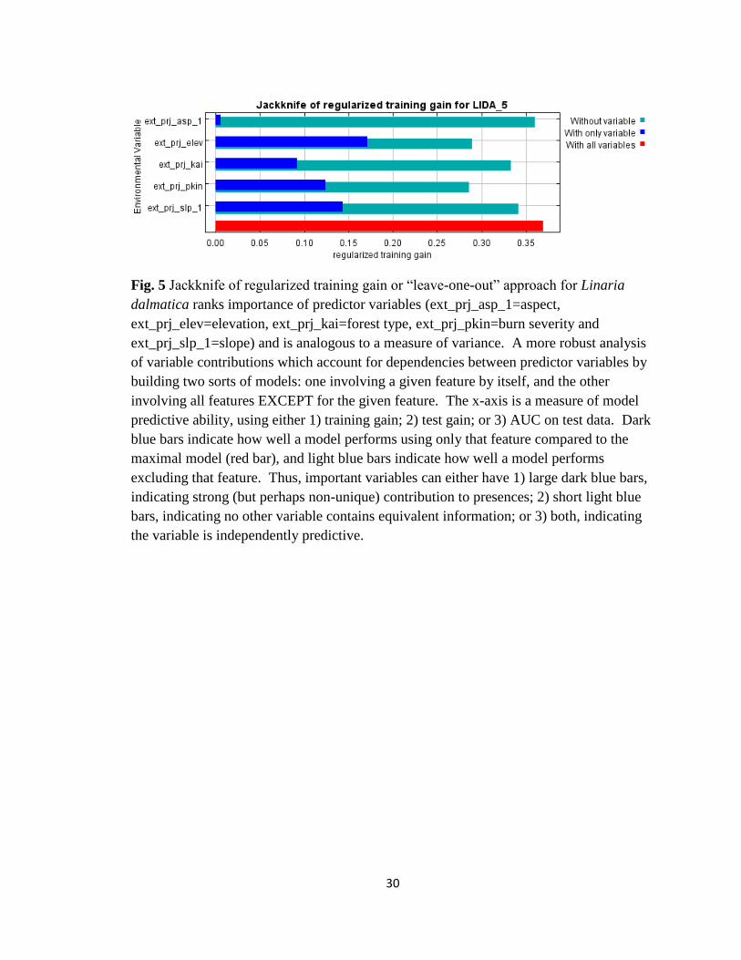
The jackknife approach (Fig. 5) showed when all the predictor variables were run
altogether (red line) that the model explained 38% of the variation in the data. Elevation
explained 18% of the variation, slope 14% and burn severity 13%. Aspect only explained
1-2% of the variation in the data and was not important to the model whether run on its
own or if it was removed.
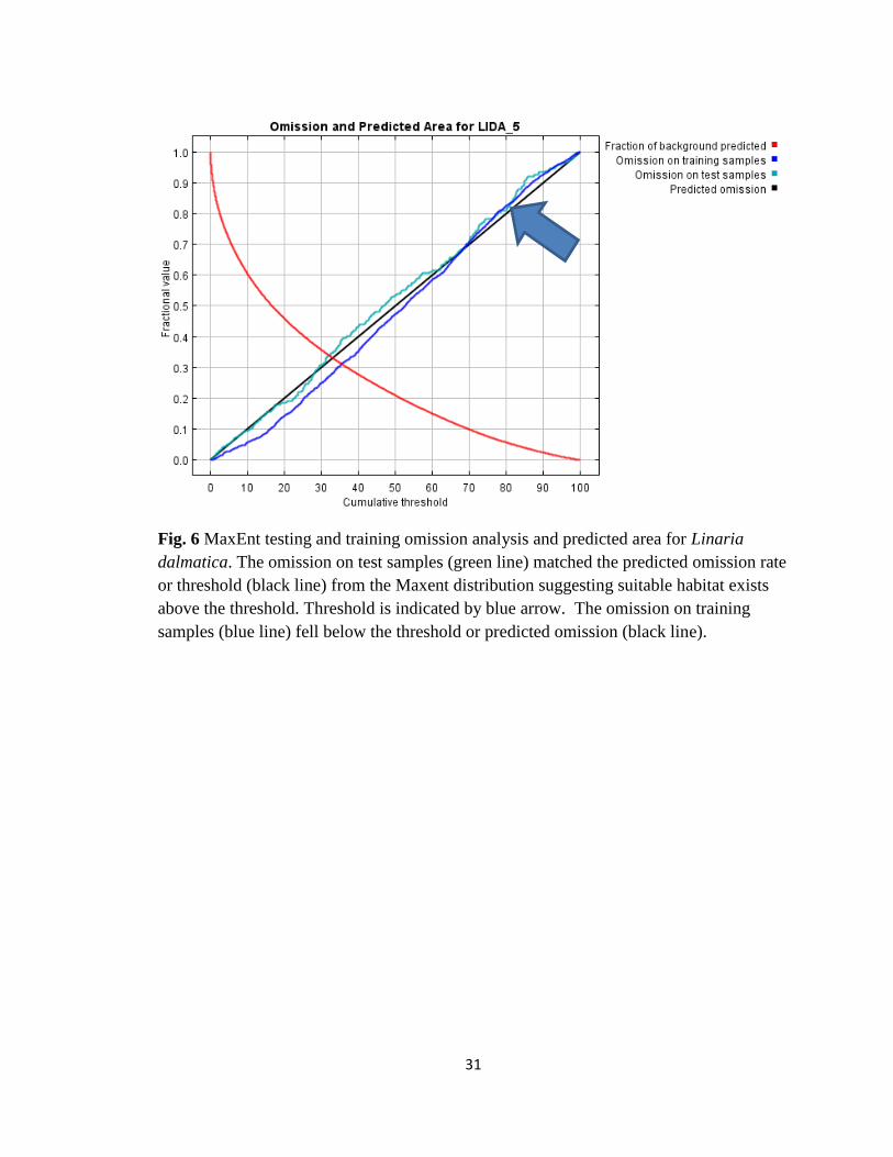
The omission/commission analysis (Fig. 6) results showed the omission on test
samples (green line) matched the predicted omission rate (black line) from the MaxEnt
distribution suggesting suitable habitat exists above the threshold. MaxEnt allows the
researcher to set a cumulative threshold value. The omission on training samples (blue
line) fell below the threshold or predicted omission (black line).
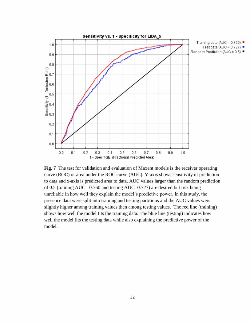
For the receiver operating curve (ROC) or area under the ROC curve (AUC)
results (Fig. 7) the model performed better than a random model as the AUC values are
larger than the random prediction of 0.5 (training AUC= 0.760 and testing AUC=0.727),
but risk being unreliable in how well they explained the model’s predictive power.

13
Because the presence data were split into training and testing partitions, the AUC values
were slightly higher among training values then among testing values.
Discussion
The MaxEnt model predicted elevation, slope and burn severity as drivers of L.
dalmatica invasion. Steep slopes and the burn severity of wildfires have been shown to
be influential in the facilitation of this species through other research (McKenzie et al
2004; Schoennagel et al. 2005; Westerling et al. 2006; Dodge et al. 2008; Blumenthal et
al. 2012). Linaria dalmatica is an opportunistic invader across the landscape from highly
disturbed to pristine areas (Crawford et al. 2001; Griffis et al. 2001; Sieg et al. 2003;
Wolfson et al. 2005; Lemke et al. 2011; Blumenthal et al. 2012) but appears to prefer
disturbed, south-facing slopes.
The relationship between elevation and presence of Linaria dalmatica in the
Kendrick Mountain Wilderness may be a function of several factors. One explanation is
that elevation is often correlated with other factors such as temperature or precipitation
(Liston et al. 2007; Dodge et al. 2008). Liston et al. (2008) found that temperature
related factors predicted the presence of L. dalmatica in another system. Liston et al.
hypothesized that dense toadflax infestations may have been associated with winter
temperatures and areas of high snow accumulation due to northwest winter winds
blowing snow onto south-facing slopes. Future SDMs should include precipitation and
temperature in factors associated with Linaria dalmatica presence in the Southwest.

14
The MaxEnt model used in this study indicated that elevation was a good
predictor of Linaria dalmatica presence and could be explained by dispersal patterns in
that L. dalmatica can be found across broad elevations. Dispersal strategies could
explain the pattern of invasion found in relation to increasing elevation either via wind or
animal dispersal. Southwestern aspects were weakly associated with the presence of this
plant owing to the possibility that predominantly western winds (Blumenthal et al. 2012)
may have aided in the upslope distribution of this plant. Another explanation may be
seed dispersal patterns although Dodge et al. (2008) found that L. dalmatica seeds are
likely to disperse shorter distances from the mother plant which turns this explanation on
its head.
There is a clear relationship between L. dalmatica and steep slopes and was
demonstrated in the research of Blumenthal et al. (2012) where they quantified
relationships between toadflax cover through high-resolution aerial imagery and relative
snow deposition. Blumenthal et al. (2012) found that toadflax occurred in 742 of 1,861 of
their images implying that it was very common throughout their 400 ha site. Linaria
dalmatica presence can be found on flat meadow openings but responds greatly to steep
slopes. The steeper the slope, the greater the plant will spread.
There is also a relationship of L. dalmatica with burn severity, which was
demonstrated in Dodge et al. (2008). Areas that had received medium to high severity
burns had experienced greater numbers of this species. L. dalmatica does not require fire
to establish, but medium to high severity burns can and often will influence plant spread.

15
Potential issues with Species Distribution Models
There are some potential issues with the MaxEnt species distribution model I
created, and most of these issues are common to all modeling approaches. These issues
include transferability, the model species’ range is still expanding, sampling distribution
bias, model evaluation, and model selection.
Over-estimates of potential impact
Distribution models of invasive plants over-estimate potential impact (Bradley
2013). This is quite common amongst species distribution models for example MaxEnt
can over-estimate potential impacts of invasive plants when presence and background
data come from the same source.
Transferability
One potential problem with the MaxEnt model is the ability to transfer findings
from the sampled area of Kendrick Mountain Wilderness to other unsampled areas. The
environmental variables that were important in this study may change when modeling
Linaria dalmatica in other areas. Therefore, results from this study should be considered
limited in scope and would not transfer to other areas of the Kaibab National Forest or
beyond.

16
Species range could still be expanding
Species distribution model predictions may under predict leading to a reduced
distribution of the species. However, the data for this model were collected 10 years or
more after the Pumpkin Fire occurred in the study area, so it is likely that Linaria
dalmatica’s range is beginning to stabilize on Kendrick Mountain (Phillips and Crisp
2001).
Sampling distribution bias
The accuracy of any model is influenced by the sampling distribution. If the
sampling distribution is biased because of the sampling method (for example, targeted
sampling near trails, roads, etc.) then the resulting model will not accurately predict the
species’ distribution across the landscape.
Model evaluation
Model evaluations provide information regarding whether a model can predict
distributions that are different than random. I used the jackknife test to assess the
importance of predictor variables in my training data, testing data, and AUC. The
jackknife approach relies on threshold values to predict presence-pseudo-absence
locations. Threshold values differ for each model, and are selected at the discretion of the
modeler. I was interested in identifying any possible area where Linaria might occur, so
I wanted to minimize commission error. Once a threshold has been identified, locations
can be classified as suitable or unsuitable for the species of interest.

17
Model selection
The best model out of a subset of potential models is model selection. I chose the
best model using the jackknife due to its robustness and ability to look at variable
contributions individually, without and in conjunction with other variables.
Management Implications
The establishment of the aggressive, exotic, noxious Linaria dalmatica in
rangelands is a problem many southwestern land managers face with limited methods to
control population spread. The Kaibab National Forest has experienced invasion of this
species over large areas in rangelands throughout the Forest, and land managers are
concerned that Linaria populations may keep spreading into the Kendrick Mountain
Wilderness and Kendrick Peak. This makes for difficulty in monitoring these invasive
populations through ground survey because of the difficult terrain and the inability to
reach many areas by foot.
Since these control efforts can be ineffective, land managers could benefit by
using MaxEnt coupled with geographic information systems (GIS) to survey these areas.
This will help guide monitoring efforts and to place emphasis on the places suitable for
establishment. Without these methods monitoring is unguided and efforts can be wasted
as well as time that can be spent on other management efforts. Remote sensing coupled
with the utility of GIS has greatly facilitated managers in geospatially collecting and
disseminating datasets (Pearson et al. 2007). Species distribution models (SDMs) such as

18
Maximum entropy (MaxEnt) have been widely used by managers to predict areas of
suitable plant invasion as well as global climate change.
Young et al. (2007) utilized GIS and MaxEnt to predict areas of invasive plant
establishment within Big Bend National Park and created an early detection management
tool. Holcombe et al. (2010) generated an efficient global climate change model utilizing
MaxEnt that helped identify the leading edge or areas of potentially suitable habitat of
Lepidium latifolium. This type of modeling is extremely important for natural areas and
allows managers to keep better track of populations through more targeted surveys and
monitoring. Much effort has been put into monitoring Linaria dalmatica populations in
the Kaibab National Forest and with these implementations the on the ground monitoring
effort can be more effective to verify and control populations (Everitt et al. 1996; Osborn
et al. 2002; Goslee et al. 2003; Parker-Williams and Hunt 2004).
There were some lessons learned during the process of creating this MaxEnt
modeling tool. First, goals and objectives of the invasive plant survey need to be made
clear. Will the survey be used as a rapid assessment of invasive plant establishment or
will it be used to monitor plants and predict new ones? Second, the sampling design
needs to be planned and well structured. If the purpose of the survey is for monitoring,
then a fixed, systematic sampling design should be implemented and the same points
visited each year. Data should be collected to determine presence and absence of
invasive species over time. Third, it was important to keep all data at the same resolution
(e.g., 30 m) during the analyses to keep data intact. Fourth, more predictor variables

19
could have been used to explore the relationship of L. dalmatica presence to
environmental factors; variables such as precipitation, temperature, soil type, geological
features, and distance to trails and water sources.

20
References
Alex JF (1962) The taxonomy, history, and distribution of Linaria dalmatica. Canadian
Journal of Botany 40: 295–306
Applied Weed Science. 2nd Ed. Merril A. Ross and Carole A. Lembe. 1999. Prentice-Hall
Inc.
Araújo MB, Luoto M (2007) The importance of biotic interactions for modelling species
distributions under climate change. Global Ecology and Biogeography 16: 743-
753
Blumenthal DM, Norton AP, Cox SE, Hardy EM, Liston GE, Kennaway L, Booth, DT,
Derner, JD (2012) Linaria dalmatica invades south-facing slopes and less grazed
areas in grazing-tolerant mixed-grass prairie. Biological Invasions 14: 95–404
Bradley BA (2013) Distribution models of invasive plants over-estimate potential impact.
Biological Invasions 15:1417-1429
Cohen WB, Goward SN (2004) Landsat’s role in ecological applications of remote
sensing. BioScience 54: 535–545
Covington WW, Moore MM (1994) Southwestern ponderosa forest structure. Journal of
Forestry 92: 39-47
Crawford JA, Wahren CHA, Kyle S, Moir WH (2001) Response of exotic species to fires
in Pinus ponderosa forests in Northern Arizona. Journal of Vegetation Science
12: 261–268
Daehler CC, Strong DR (1994) Variable reproductive output among clones of Spartina
alterniflora (Poaceae) invading San Francisco Bay, California: the influence of
herbivory, pollination, and establishment site. American Journal of Botany 81:
307–313
D’Antonio CM, Vitousek PM (1992) Biological invasions by exotic grasses, the grass
fire, cycle, and global change. Annual Review of Ecology and Systematics
23: 63-65
D'Antonio CM (2000) Fire, plant invasions, and global changes. Pages. 65–93. in
Mooney HA, Hobbs RJ, eds. Invasive Species in a Changing World. Washington
(DC): Island Press

21
D’Antonio C, Meyerson LA (2002) Exotic plant species as problems and solutions in
ecological restoration: A synthesis. Restoration Ecology 10: 703–71
DiTomaso JM (2000) Invasive weeds in rangelands: species, impacts, and management.
Weed Science 48:255–265
Dodge RS, Fulé PZ, Sieg, CH (2008) Dalmatian toadflax (Linaria dalmatica) response to
wildfire in a southwestern USA forest. Ecoscience 15: 213–222
Ehrenfeld JG (2003) Effects of exotic plant invasions on soil nutrient cycling processes.
Ecosystems 6:503–523
Elith J, Graham CH, Anderson RP et al. (2006) Novel methods improve prediction of
species’ distributions from occurrence data. Ecography 29:129–151
Elith J, Leathwick JR (2009) Species distribution models: ecological explanation and
prediction across space and time. Annual Review of Ecology, Evolution and
Systematics 40: 677– 697
Elith J, Phillips S J, Hastie T, Dudik M, Chee YE, Yates CJ (2011) A statistical
explanation of MaxEnt for ecologists. Diversity and Distributions 17: 43–57
Environmental Systems Research Institute (ESRI), (2015) ArcGIS Desktop Help 10.3
Geostatistical Analyst
Everitt J, Escobar D, Alaniz M, Davis M, Richerson J (1996) Using spatial information
technologies to map Chinese tamarisk (Tamarix chinensis) infestations. Weed
Science 44: 194–201
García-Domínguez C, Fernández-Palacios JM (2009) Effect of fire intensity on non-
native plant species community in a Canarian pine forest three and eleven years
after fire. The Open Forest Science Journal 2: 70–77.
Goslee SC, Havstad KM, Peters DPC, Rango A, Schlesinger WH (2003) High-resolution
images reveal rate and pattern of shrub encroachment over six decades in New
Mexico, USA. Journal of Arid Environments 54: 755-767
Grace J, Malhi Y, Higuchi N, Meir P (2001) Productivity of tropical rain forests.
Terrestrial Global Productivity: Past, Present and Future (ed. by H. Mooney, J.
Roy and B. Saugier), pp. 401–426. Academic Press, San Diego, CA

22
Griffis K L, Crawford JA, Wagner MR, Moir WH (2001) Understory response of
management treatments in northern Arizona ponderosa pine forests. Forest
Ecology and Management 146: 239– 245
Guisan A, Zimmermann NE (2000) Predictive habitat distribution models in ecology.
Ecological Modelling 135: 147–186
Higman PJ, MR Penskar, Y Lee, MA Sanders, and RL Rogers (2012) Garden Island Rare
Species and Invasive Plant Survey. Michigan Natural Features Inventory, Report
Number 2012-02 Lansing, MI. 33 pp. plus 3 appendices
Holcombe TR, Stohlgren TJ, Jarnevich CS (2010) From points to forecasts: predicting
invasive species habitat suitability in the near term. Diversity 2: 738–767
Huisinga KD, Laughlin DC, Fulé PZ, Springer JD, McGlone CM (2005) Effects of an
intense prescribed fire on understory vegetation in a mixed conifer forest. Journal
of the Torrey Botanical Society 132: 590–601
Hunter ME, Omi PN, Martinson EJ, and Chong GW (2006) Establishment of non-native
plant species after wildfires: effects of fuel treatments, abiotic and biotic factors,
and post fire grass seeding treatments. International Journal of Wildland Fire
15: 271–281.
Keeley JE, Lubin D, Fotheringham CJ (2003) Fire and grazing impacts on plant diversity
and alien plant invasions in the southern Sierra Nevada. Ecological Applications
13: 1355–1374
Keeley JE (2004) Invasive plants and fire management in California Mediterranean
climate ecosystems. In M. Arianoutsou, editor. 10th MEDECOS—international
conference on ecology, conservation and management. Rhodes, Greece
Kerns BK, Thies WG, Niwa CG (2006) Season and severity of prescribed burn in
ponderosa pine forests: Implications for understory native and exotic plants.
Ecoscience 13: 44–55
Korb J, Springer J (2003) Understory vegetation. Pages 233–250 in P. Friederici (ed.).
Ecological Restoration of Southwestern Ponderosa Pine Forests. Island Press,
Washington, DC
Kuenzi AM, Fulé PZ, Sieg CH (2008) Effects of fire severity and pre-fire stand treatment
on plant community recovery after a large wildfire. Forest Ecology and
Management 225: 855–865

23
Lass LW, Prather TS, Glenn NF, Weber KT, Mundt JT, Pettingill J (2005) A review of
remote sensing of invasive weeds and example of the early detection of spotted
knapweed (Centurea maculosa) and babysbreath (Gypsophila paniculata) with a
hyperspectral sensor. Weed Science 53: 242-251
Lemke D, Hulme PE, Brown JA, Tadesse W (2011) Distribution modelling of Japanese
honeysuckle (Lonicera japonica) invasion in the Cumberland Plateau and
Mountain Region, USA. Forest Ecology and Management 262: 139-149
Levine JM, Vila M, D’Antonio C, Dukes JS, Grigulis K, Lavorel S (2003) Mechanisms
underlying the impact of exotic plant invasions. Philosophical Transactions of the
Royal Society 270: 775–781
Liston GE, Haehnel RB, Sturm M, Hiemstra CA, Berezovskaya S, Tabler RD (2007)
Instruments and methods simulating complex snow distributions in windy
environments using SnowTran-3D. Journal of Glaciology 53: 241–256
McGranahan DA, Engle DM, Wilsey BJ, Fuhlendorf SD, Miller JR, Debinski DM (2012)
Grazing and an invasive grass confound spatial pattern of exotic and native
grassland plant species richness. Basic and Applied Ecology 13: 654– 662
McKenzie D, Gedalof ZM, Peterson DL, Mote P (2004) Climatic change, wildfire, and
conservation. Conservation Biology 18: 890-902
Merow C, Smith, MJ and Silander Jr JA (2013) A practical guide to MaxEnt for
modeling species’ distributions: what it does, and why inputs and settings matter.
Ecography 36: 42-91
Natural Resources Conservation Service, Soil Survey Staff United States Department of
Agriculture (2006) Land Resource Regions and Major Land Resource Areas of
the United States, the Caribbean, and the Pacific Basin. Agricultural Handbook
296 digital maps and attributes. Available online. Accessed [09/01/2015]
Natural Resources Conservation Service, Soil Survey Staff, United States Department of
Agriculture (2007) Land Resource Regions and Major Land Resource Areas of
the United States, the Caribbean, and the Pacific Basin. Agricultural Handbook
296 digital maps and attributes. Available online. Accessed [08/05/2015]
Nordén B, Dahlberg A, Brandrud TE, Fritz O, Ejrnaes R, and Ovaskainen O (2014)
Ecoscience 21: 34-45
Osborn S, Wright V, Walker B, Cilimburg A, Perkins A (2002) Understanding and
managing invasive Plants in Wilderness and other Natural Areas: An Annotated

24
Reading List. USDA Forest Service General Technical Report RMRS-GTR-79-
VOL-4
Parker Williams AE, Hunt ER, Jr. (2004) Estimation of leafy spurge cover from
hyperspectral imagery using mixture tuned matched filtering. Remote Sensing of
Environment 82: 446-456
Pearson RG, Raxworthy CJ, Nakamura M, Townsend Peterson A (2007) Predicting
species distributions from small numbers of occurrence records: a test case using
cryptic geckos in Madagascar. Journal of Biogeography 34:102–117
Peterson EB (2005) Estimating cover of an invasive grass (Bromus tectorum) using logit
regression and phenology derived from two dates of Landsat ETM plus data.
International Journal of Remote Sensing 26: 2491–2507
Phillips B, Crisp D (2001) Dalmatian toadflax, an invasive exotic noxious weed,
threatens Flagstaff pennyroyal community following prescribed fire. Pages 200–
205 in J. Maschinski & L. Holter (eds.). Southwestern Rare and Endangered
Plants: Proceedings of the Third Conference. USDA Forest Service Proceedings
RMRS-P-23, Fort Collins, Colorado
Phillips SJ, Anderson RP, Schapire RE (2006) Maximum entropy modeling of species
geographic distributions. Ecological Modelling 190: 231–259
Rew LJ, Pokorny ML (ed.) (2006) Inventory and Survey Methods for Nonindigenous
Plant Species. Bozeman, MT: Center for Invasive Plant Management.
http://www.weedcenter.org/outreach/project-webseminar.html
Richardson DM, Pysek P, Rejmánek M, Barbour MG, Panetta FD, West CJ (2000)
Naturalization and invasion of alien plants: Concepts and definitions. Diversity
and Distributions 6: 93–107
Schoennagel T, Veblen TT, Romme WH, Sibold JS, Cook ER (2005) ENSO and PDO
variability affect drought induced fire occurrence in Rocky Mountain subalpine
forests. Ecological Applications 15: 2000–2014
Sieg CH, Phillips BG, Moser LP (2003) Exotic invasive plants. Pages 251–267 in P.
Friederici (ed.). Ecological Restoration of Southwestern Ponderosa Pine Forests.
Island Press, Washington, DC
Swetnam TW, Allen CD, Betancourt JL (1999) Applied historical ecology: Using the
past to manage for the future. Ecological Applications 9: 1189–1206

25
Vitousek M (1990) Biological invasions and ecosystem processes: towards an
integration of population biology and ecosystem studies. Oikos 57: 7–13
Vitousek P, D’Antonio CM, Loope LL, Rejmanek M, Westbrooks R (1997) Introduced
species: a significant component of human-caused global change. New
Zealand Journal of Ecology 21: 1–16 Nature 388: 627–628
Vujnovic K, Wein RW (1996) The biology of Canadian weeds: Linaria dalmatica
(L.) Mill. Canadian Journal of Plant Science 77: 483–491
Walker LRS, Smith D (1997) Impacts of invasive plants on community and
ecosystem properties. Pages 69–85 in J. O. Luken & J. W. Thieret
(eds.). Assessment and Management of Plant Invasions. Springer,
New York, New York
Westerling AL, Hidalgo HG, Cayan DR, Swetnam TW (2006) Warming and
earlier spring increases western U.S. forest wildfire activity. Science 313:
940–943
Wilcove DS, Rothstein D, Dubow J, Phillips A, Losos E (1998) Quantifying threats
to imperiled species in the United States. BioScience 48: 607–15
Williams NSG, Schwartz MW, Vesk PA, McCarthy MA, Hahs AK, Clements SE,
Corlett RT, Duncan RP, Norton BA, Thompson K, and McDonnell MJ
(2009) A conceptual framework for predicting the effects of urban
environments on floras. Journal of Ecology 97: 4–9
Williamson MH (1996) Biological Invasions. Chapman & Hall, London
Wolfson BAS, Kolb TE, Sieg CH, Clancy KM (2005) Effects of post-fire conditions on
germination and seedling success of diffuse knapweed in northern Arizona.
Forest Ecology and Management 216: 342–358
Young KE, Schrader TS, Boykin KG, Caldwell C, Roemer GW (2007) Early
Detection of Invasive Species in Big Bend National Park: Remote Sensing
and GIS Strategies. New Mexico Cooperative Fish and Wildlife Research
Unit. Las Cruces, New Mexico. 103 pp + appendices
Zouhar KL (2003) Linaria spp. [online]. Fire Effects Information System, Fire Sciences
Laboratory, Rocky Mountain Research Station, USDA Forest Service.
Available from: http://www.fs.fed.us/database/feis/
26
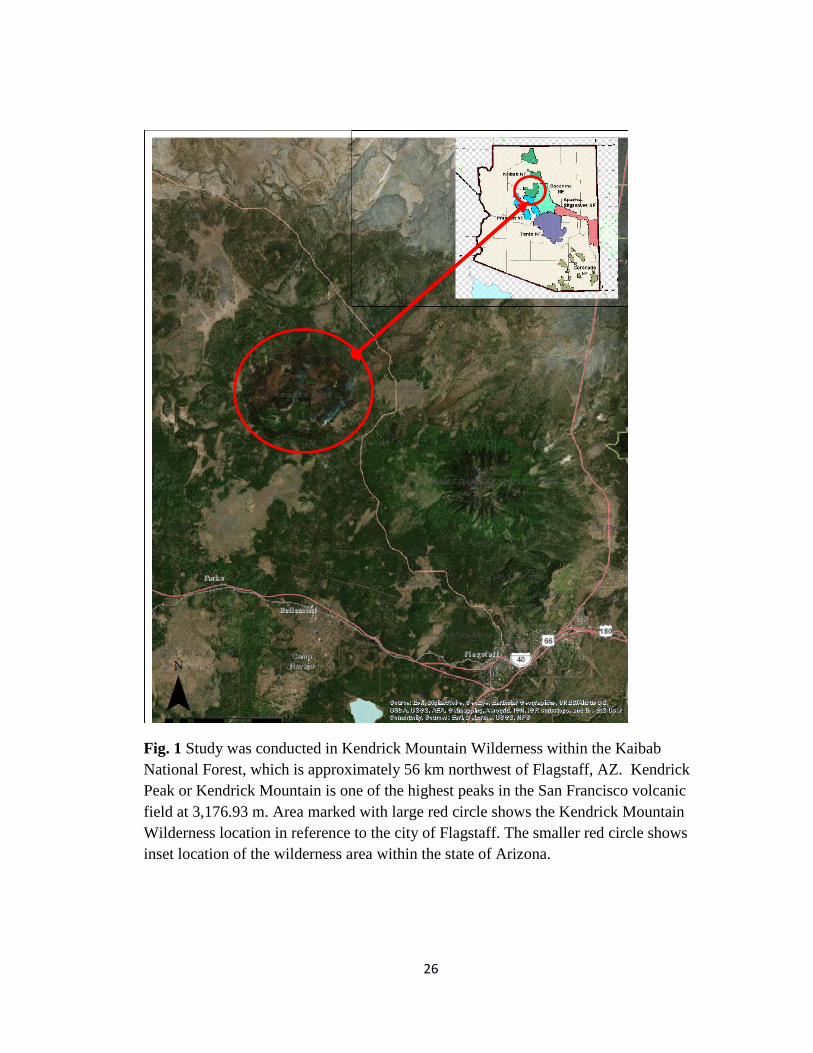
Fig. 1 Study was conducted in Kendrick Mountain Wilderness within the Kaibab
National Forest, which is approximately 56 km northwest of Flagstaff, AZ. Kendrick
Peak or Kendrick Mountain is one of the highest peaks in the San Francisco volcanic
field at 3,176.93 m. Area marked with large red circle shows the Kendrick Mountain
Wilderness location in reference to the city of Flagstaff. The smaller red circle shows
inset location of the wilderness area within the state of Arizona.

27
Fig. 2 Pumpkin Fire burn severity map created by USFS Kaibab National Forest. Levels
of burn severity are color coded with acreage amounts affected by Pumpkin Fire. Olive
green is unburned (416 ha, 1028.2 ac.), lime green is low severity burn (3,211 ha, 7936.7
ac.), yellow is moderate severity burn (694 ha, 1715.8 ac.) and orange is high severity
burn (2,061 ha, 5094.7 ac.).

28
Fig. 3 ArcMap 10.3 map of presence-only polygon locations for Linaria dalmatica
constrained within the study area of Kendrick Mountain Wilderness. Fifty-one polygons
in all were collected to compile presence-only locations.

29
Fig. 4 Map showing boundary of Kendrick Mountain Wilderness with converted L.
dalmatica polygons to sample points shown in red
30
Fig. 5 Jackknife of regularized training gain or “leave-one-out” approach for Linaria
dalmatica ranks importance of predictor variables (ext_prj_asp_1=aspect,
ext_prj_elev=elevation, ext_prj_kai=forest type, ext_prj_pkin=burn severity and
ext_prj_slp_1=slope) and is analogous to a measure of variance. A more robust analysis
of variable contributions which account for dependencies between predictor variables by
building two sorts of models: one involving a given feature by itself, and the other
involving all features EXCEPT for the given feature. The x-axis is a measure of model
predictive ability, using either 1) training gain; 2) test gain; or 3) AUC on test data. Dark
blue bars indicate how well a model performs using only that feature compared to the
maximal model (red bar), and light blue bars indicate how well a model performs
excluding that feature. Thus, important variables can either have 1) large dark blue bars,
indicating strong (but perhaps non-unique) contribution to presences; 2) short light blue
bars, indicating no other variable contains equivalent information; or 3) both, indicating
the variable is independently predictive.
31
Fig. 6 MaxEnt testing and training omission analysis and predicted area for Linaria
dalmatica. The omission on test samples (green line) matched the predicted omission rate
or threshold (black line) from the Maxent distribution suggesting suitable habitat exists
above the threshold. Threshold is indicated by blue arrow. The omission on training
samples (blue line) fell below the threshold or predicted omission (black line).
32
Fig. 7 The test for validation and evaluation of Maxent models is the receiver operating
curve (ROC) or area under the ROC curve (AUC). Y-axis shows sensitivity of prediction
to data and x-axis is predicted area to data. AUC values larger than the random prediction
of 0.5 (training AUC= 0.760 and testing AUC=0.727) are desired but risk being
unreliable in how well they explain the model’s predictive power. In this study, the
presence data were split into training and testing partitions and the AUC values were
slightly higher among training values then among testing values. The red line (training)
shows how well the model fits the training data. The blue line (testing) indicates how
well the model fits the testing data while also explaining the predictive power of the
model.

33
Fig. 8 Response curve for elevation and Linaria dalmatica showing on y-axis probability
of presence and on x-axis levels of elevation. An increase of elevation correlates with an
increase in the probability of Linaria dalmatica presence. The drop in probability from
2900 m to 3100 m may be an artifact of L. dalmatica not being present at those
elevations.
34
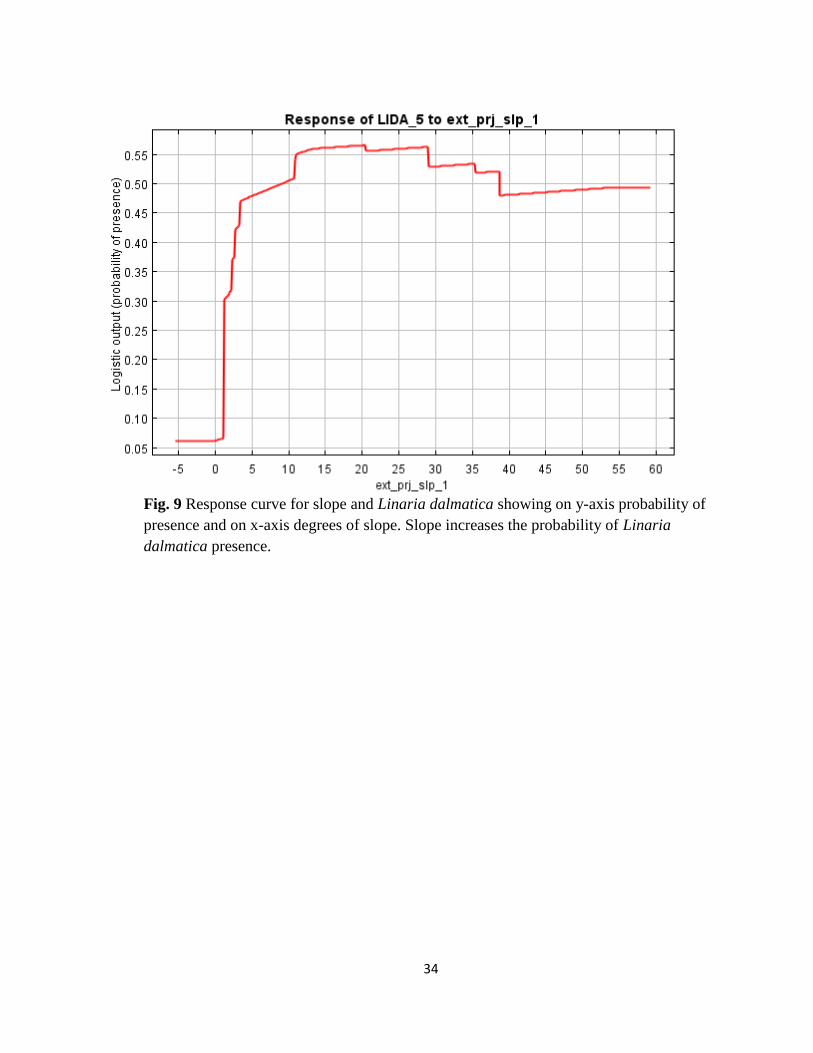
Fig. 9 Response curve for slope and Linaria dalmatica showing on y-axis probability of
presence and on x-axis degrees of slope. Slope increases the probability of Linaria
dalmatica presence.
35
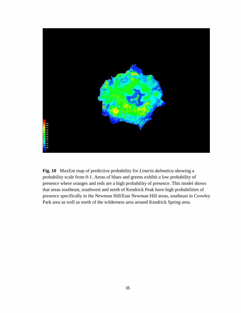
Fig. 10 MaxEnt map of predictive probability for Linaria dalmatica showing a
probability scale from 0-1. Areas of blues and greens exhibit a low probability of
presence where oranges and reds are a high probability of presence. This model shows
that areas southeast, southwest and north of Kendrick Peak have high probabilities of
presence specifically in the Newman Hill/East Newman Hill areas, southeast in Crowley
Park area as well as north of the wilderness area around Kendrick Spring area.