a survey of the roadside conservation values in the shire
TRANSCRIPT

A Survey of Roadside
Conservation Values in
the Shire of Broomehill
and Roadside Management
Guidelines
November 2002 – Roadside Conservation Committee

A survey of the roadside conservation values in the Shire of Broomehill and roadside management guidelines
CONTENTS
Introduction 3
Value of Roadsides 3
Legislation 4
Assessment Process 5
- Methods 5
- Quantifying conservation values 6
- Mapping Conservation Values 6
Survey Data Results 8
Management Techniques 13
Code of Practice 14
Tree Roads 14
Flora Roads and Roads Important for Conservation 14
Special Environment Areas 15
Roadside Management Strategies 16
Roadside Action Plans 18
References 19

A survey of the roadside conservation values in the Shire of Broomehill and roadside management guidelines
FIGURES
Figure 1. Climate Statistics
Figure 2. Conservation Status of Roadsides in the
Shire of Broomehill
Figure 3. Native Vegetation on Roadsides
Figure 4. Extent of Native Vegetation
Figure 5. Number of Native Species
Figure 6. Weed Infestation
Figure 7. Value as a Biological Corridor
Figure 8. Adjoining Land Use
Figure 9. SEA Site Marker
Figure 10. Marking Sites in the Field
TABLES
Table 1. Colour Codes Used to Depict the Conservation
Status of Roadsides
Table 2. Summary of Roadside Conditions in the Shire
of Broomehill
APPENDICES
Appendix 1. Definitions of Remnant Vegetation Types
Appendix 2. Standard Survey Sheet
Appendix 3. Raw Data Used to Calculate Conservation Values
Appendix 4. Plant Species in the Shire of Broomehill

INTRODUCTION
The Shire of Broomehill covers an area of 1,376 km2 and supports a population of
approximately 550 people. The area experiences a mediterranean climate with an
average annual rainfall of 491 mm. Seasonal temperatures are characterised by warm
summers, with maxima averaging from the mid to high twenties, and mild winters, with
maxima in the mid teens. Mean daily maximum and minimum temperatures and rainfalls
are shown below.
0
10
20
30
40
50
60
70
80
90
J F M A M J J A S O N D
Month
Rai
nfal
l (m
m)
0
5
10
15
20
25
30
35
Tem
pera
ture
(o C)
Mean monthly rainfall - mmMean daily maximum temperature - deg CMean daily minimum temperature - deg C
Figure 1 – Mean daily maximum and minimum temperature (oC) and rainfall (mm) in the Shire of Broomehill.
Broomehill is located 302 km south east of Perth in Western Australia’s south west land
division. The major agricultural pursuits and industries in the area are sheep, cattle,
cereal crops, aquaculture and viticulture. Tourism is also an important industry, with the
area’s spectacular natural resources, such as wildflowers, being a major attraction. The
Holland Track, Boot Rock Reserve and Old Eticup settlement and cemetary are salient
features of the area.
The WA herbarium records more than 130 species of plants from the Shire of
Broomehill. Of these, 18 are Acacia species and 17 are Eucalypt species.
VALUE OF ROADSIDES
Since the settlement of Western Australia by Europeans, large areas of native
vegetation in the south west of the state have been cleared for agriculture, roads,
A survey of the roadside conservation values in the Shire of Broomehill and roadside management guidelines

A survey of the roadside conservation values in the Shire of Broomehill and roadside management guidelines
settlements, and other development. The fragmentation of the more or less continuous
expanse of native vegetation communities by clearing has resulted in the isolation of
plant and animal populations, restricted by man-made biogeographical islands of small
remnants. They are prone to food shortages, disease and reduced genetic diversity.
However, the presence of native vegetation along roadsides can often assist in
alleviating this isolation effect by providing connectivity between bush remnants, thereby
facilitating the movement of biota across the landscape. Unfortunately, the protective
role provided by the native flora has been badly depleted with now only 6-7% of the
remnant vegetation remaining in the Shire of Broomehill.
Remnant vegetation includes more than just trees. Trees, shrubs and ground covers
(creepers, grasses and herbs) combine to provide valuable food and shelter for different
types of wildlife. Existing native vegetation will require less maintenance if left
undisturbed.
Trees are good – bush is better Local indigenous trees, shrubs and grasses on the roadside are valuable because they:
- are often the only remaining example of original vegetation within extensively
cleared areas;
- are easier to maintain and generally less fire prone than introduced
vegetation;
- provide habitat for many native species of plants, mammals, reptiles,
amphibians and invertebrates;
- provide wildlife corridors linking other areas of native vegetation;
- often contain rare and endangered plants and animals. Currently, roadside
plants represent more than 80 per cent of the known populations of 40 of the
declared rare species, and three of these are known only to exist in roadside
populations;
- provide the basis for our important wildflower tourism industry. The aesthetic
appeal of well-maintained roadsides should not be overlooked, and they have
the potential to improve local tourism and provide a sense of place;
- often contain sites of historic or cultural significance;
- provide windbreaks and stock shelter areas for adjoining farmland by helping
to stabilise temperature and reduce evaporation.
- assist with erosion and salinity control, and not only in the land adjoining the
road reserve per se;
- are generally far less of a fire threat than annual weeds;
- provide a benchmark for the study of soil change throughout the development
of agriculture;

A survey of the roadside conservation values in the Shire of Broomehill and roadside management guidelines
- are a vital source of local seed for revegetation projects in the absence of
other alternatives;
- provide a valuable source of seed for regeneration projects. This is especially
pertinent to shrub species, as clearing and grazing beneath farm trees often
removes this layer;
Approval of the local shire and a CALM permit are required prior to collection.
In a time of rapid change, where the demands placed on the natural world are many, it is
vital that there is a coordinated management of lands across all tenures and boundaries
to ensure the sustainability and integrity of the natural biota and ecosystem processes,
agricultural lands and service infrastructure.
Roadsides are the vital link ……………………. and a priceless community asset. LEGISLATION
Uncertainty often exists in the minds of many with regard to the ‘ownership’, control and
management of the roadside. When a public road is created, a corridor of land is
dedicated for a road, i.e. a road reserve. The road formation and its associated
infrastructure are accommodated for within the road reserve. The remaining area on
each side of the road is called the road verge or roadside. It is in the control and
management responsibilities of this area (and the plants and animals residing within it)
that the uncertainty exists.
See David’s legislation material
With the proclamation of the Wildlife Conservation Act 1950 the responsibility for flora
conservation, including the control of harvesting of protected flora, this includes seed,
was given to the Minister of the Crown responsible for Fisheries and Wildlife and the
Department of Fisheries and Wildlife. With the formation of the Department of
Conservation and Land Management in 1984 (now the Department of Conservation) and
the accompanying Conservation and Land Management Act 1984 the conservation
and management of all native wildlife passed to the Minister responsible for that
Department and the Department itself. As a consequence the Department of
Conservation has the authority to exert controls.

A survey of the roadside conservation values in the Shire of Broomehill and roadside management guidelines
ASSESSMENT PROCESS Methods The methods to assess and calculate the conservation value of the roadside reserves
are described in Hussey (1991). The process involves scoring a set of pre-selected
attributes, which, when combined, represent a roadside's conservation status. A list of
these attributes is presented on a standard survey sheet, see Appendix 2. This provides
both a convenient and uniform method of scoring. Ideally, the survey is undertaken by a
group of local volunteers, who, aided by their knowledge of the area, are able to provide
an accurate and cost effective method of data collection. Community participation also
ensures a sense of ownership of the end product, which increases the likelihood of its
acceptance and use by the local community and road managers. Lamont and Blyth
(1995).
Fieldwork was carried out throughout the month of October 2001. The enthusiastic
efforts of the volunteer surveyors and of project coordinator Anthony Witham ensured
that this project was successfully completed. It is now hoped that the data collected will
be used by all sectors of the community who have an interest in the roadside
environment. Quantifying Conservation Values
The following attributes were used to produce a quantitative measure of conservation
value:
- native vegetation on roadside;
- extent of native vegetation along length of roadside;
- number of different native species;
- weed infestation;
- value as a biological corridor;
- predominant adjoining land use.
Each of these attributes was given a score ranging from 0 to 2 points. The combined
scores provide a conservation score ranging from 0 to 12. The conservation values, in
the form of conservation status categories, are represented by the following colour
codes
Conservation Value Conservation Status Colour Code
9 – 12 High� Dark Green� 7 – 8� Medium High� Light Green� 5 – 6� Medium Low� Dark Yellow� 0 – 4� Low� Light Yellow�
Table 1: Colour codes used to depict the conservation status of roadsides.

A survey of the roadside conservation values in the Shire of Broomehill and roadside management guidelines
The following attributes were also noted but did not contribute to the conservation value
score:
• width of road reserve;
• width of vegetated roadside;
• presence of utilities/disturbances;
• dominant native species;
• dominant weeds;
• fauna observed;
• general comments.
It is felt that the recording of these attributes will provide a community database that
would provide information useful in many spheres local government and community
interest.
Mapping Conservation Values A computer generated map (using a Geographic Information System, or GIS), at a scale
of 1:100 000, depicting the conservation status of the roadside vegetation and the width
of the road reserves within the Shire of Broomehill was produced. The data used to
produce both the map and the following figures and tables are presented in Appendix 3.
The roadside conservation values map initially provides an inventory of the status quo of
the condition of the roadside vegetation. This is important as quality of roadside
vegetation has far reaching implications for sustaining biodiversity, tourism and
Landcare values. Moreover the data and map can be incorporated as a management
and planning tool for managing the roadsides per se, as it enables the condition of
roadside vegetation to be easily assessed. This information can then be used to identify
environmentally sensitive areas, high conservation roadsides or strategically important
areas, and thus ensure their conservation. Conversely, it enables degraded areas to be
identified as areas important for strategic rehabilitation, or in need of specific
management techniques and weed control programmes.
The map can also be used as a reference to overlay transparencies of other information
relevant to roadside conservation. Data obtained from the Department of Conservation
and Land Management and the Department of Agriculture Western Australia can been
used to produce an overlay map that depicts the location of remnant vegetation on both
the Crown estate and privately owned land. This enables the roadside vegetation to be
assessed in the context of its importance to the shire’s overall conservation network.

A survey of the roadside conservation values in the Shire of Broomehill and roadside management guidelines
Other overlays, such as the degree of weed infestation, or the location of
environmentally sensitive areas or future planned developments, could also be produced
as an aid to roadside management.
As well as providing a road reserve planning and management tool, the survey data can
also be used for:
• regional or district fire management plans;
• tourist routes - roads depicted as high conservation value would provide visitors to
the district with an insight to the flora of the district;
• Landcare / Bushcare projects - would be able to incorporate the information from this
survey into 'whole of' landscape projects.

A survey of the roadside conservation values in the Shire of Broomehill and roadside management guidelines
SURVEY DATA RESULTS
A summary of the general roadside conditions in the Shire of Broomehill is presented in
Table 2. The survey data has been combined to provide the total kilometres, and
percentages, of roadside occupied by each of the conservation status categories and the
attributes used to calculate the conservation values (see Table 2). As roadsides occur
on both sides of the road, roadside distances (km) are equal to twice the actual distance
of road travelled.
Summary Information: Shire of Broomehill Length of shire controlled road surveyed:
460 km Conservation Status Native Vegetation on
RoadsideWeed Infestation
(km) (%) (km) (%) (km) % High (9-12) 265.1 28.8 2-3 veg layers (2) 664.5 72.2 Light (2) 19.8 2.2 Med-High (7-8) 402.7 43.8 1 veg layer (1) 231.5 25.2 Medium (1) 758.3 82.4 Med-Low (5-6) 168.7 18.3 0 veg layers (0) 7.4 0.8 Heavy (0) 125.4 13.6 Low (0-4) 83.5 9.1 Data absent 16.6 1.8 Data absent 16.6 1.8
Total 920.0 100.0 Total 920.0 100.0 Total 920.0 100.0
Conservation Values Extent of Native Vegetation Value as a Biological Corridor
(km) (%) (km) (%) km % 1 1.9 0.2 >80%, Good (2) 26.6 2.9 High (2) 522.3 56.8 2 9.7 1.1 20-80%, Med (1) 759 82.5 Medium (1) 212.7 23.1 3 39.0 4.2 <20%, Low (0) 117.8 12.8 Low (0) 168.4 18.3 4 32.9 3.6 Data absent 16.6 1.8 Data absent 16.6 1.8 5 83.5 9.1 6 85.2 9.3 Total 920.0 100.0 Total 920 100.0 7 155.6 16.9 8 247.0 26.8 Number of native species Adjoining landuse9 230.6 25.1 (km) (%) km %
10 26.3 2.9 Over 20 (2) 68.6 7.5 Cleared 475.2 51.7 11 7.1 0.8 6-19 (1) 657.6 71.5 Scattered 417.2 45.3 12 1.2 0.1 0-5 (0) 177.2 19.3 Uncleared 21.1 2.3
Data absent 16.6 1.8 Other 0.0 0.0 Total 920.0 100.0 Urban 0.0 0.0
Total 920.0 100.0 Railway 6.5 0.7 Drain 0.0 0.0
Plantation 0.0 0.0 Total 920.0 100.0
Table 2: Summary of roadside conditions along roads in the Shire of Broomehill.

Roadside sections of high conservation value covered 265.1 km of roadside, 29% of the
length of roadside surveyed. Medium-high conservation areas accounted for 402.7 km of
roadside, 44% of the total surveyed. Medium-low conservation roadside covered 168.7
km, 18.% of the total surveyed. Areas of low conservation value occupied 83.5km, 9% of
the roadside surveyed (Table 2, Figure 2).
Medium-Low conservation value (5-6)
18%
Medium-High conservation value(7-8)
44%
High conservation value (9-12)29%
Low conservation value(0-4)9%
Figure 2 – Conservation status of roadsides in the Shire of Broomehill
The ‘ native vegetation on roadside’ value is determined from the number of native
vegetation layers from either the tree, shrub or ground layers. Sections with at least two
layers of native vegetation covered 72.2% of the roadside. 25.2% had only one layer and
0.8% had no layers of native vegetation (Table 2, Figure 3).
Data absent 2%
0 Vegetation layers1%
1 Vegetation layer25%
2-3 Vegetation layers 72%
Figure 3 – Native vegetation on roadsides
A survey of the roadside conservation values in the Shire of Broomehill and roadside management guidelines

Roadside vegetation with extensive cover, i.e. greater than 80%, occurred along 2.6% of
the length of road surveyed. Survey sections with 20 to 80% cover accounted for 82.5%
of the roadsides. The remaining 12.8% had less than 20% native vegetation, and
therefore, low ‘extent of native vegetation’ value.
Figure 4 – Extent of native vegetation
Data absent2%
>80%, Good vegetation cover
3%<20%, Low vegetation cover13%
20-80%, Medium vegetation cover
82%
The ‘number of native species’ score provides a measure of the diversity of the
vegetation. Survey sections with more than 20 plant species spanned 68.6 km (7.5%) of
the roadside. Roadside sections with 6 to 19 plant species accounted for 657.6 km
(71.5%) of the roadside. The remaining 117.8 km (12.8%) had less than 6 plant species.
(Table 2, Figure 5).
Figure 5 – Number of native species
6-19 Native species72%
Over 20 native species7%
0-5 Native species19%
Data absent2%
A survey of the roadside conservation values in the Shire of Broomehill and roadside management guidelines

2.2% (19.8 km) of the roadsides surveyed were only lightly affected by weeds. Medium
level weed infestation occurred on 82.4% (758.3 km) of the roadsides. 13.6% (125.4 km)
was heavily infested with weeds. (Table 2, Figure 6).
Figure 6 – Weed infestation. Light weed infestation = weeds less than 20% of ground layer. Medium weed infestation = weeds 20 to 80% of the ground layer. Heavy infestation = weeds more than 80% of the ground layer.
Heavy weed infestation14%
Data absent2%
Light weed infestation2%
Medium weed infestation82%
The ‘value as a biological corridor’ score is largely dependent upon the diversity of
habitat and whether the corridor connects areas of uncleared land. Roadsides
determined to have high value as biological corridors (as determined by the roadside
surveyors) were present along 56.8% (522.3 km) of the roadside, medium value made
up 23.1% (212.7 km), and low value corridor along 18.3% (168.4 km) of the roads
surveyed.
Figure 7 – Value as a biological corridor
Data absent2%
Low value as a biological corridor
18%
M edium value as a biological corridor
23%High value as a biological
corridor57%
A survey of the roadside conservation values in the Shire of Broomehill and roadside management guidelines

A scattered distribution of native vegetation was present on the land adjoining 45.3%
(417.2 km) of the roadside, whilst 2.3% of roadside was adjoined by land that had not
been cleared. 51.7% of the roadside surveyed was adjoined by land that had been
totally cleared of vegetation. Railway reserve adjoined the remaining 0.7% (6.5 km).
(Table 2, Figure 8)
Figure 8 – Adjoining landuse
Railway1%
Uncleared2%
Scattered45%
Cleared52%
A survey of the roadside conservation values in the Shire of Broomehill and roadside management guidelines

A survey of the roadside conservation values in the Shire of Broomehill and roadside management guidelines
MANAGEMENT TECHNIQUES
The following section provides management recommendations that will assist in
retaining and enhancing roadside conservation value. These guidelines are taken from
the Roadside Conservation Committee’s Roadside Manual and or the Roadside
Handbook. The Executive Officer of the Roadside Conservation Committee is also
available to assist on all roadside conservation matters, and can be contacted on (08)
9334 0423. The primary aim of road management is the creation and maintenance of a
safe, efficient road system. However, the following management procedures should be
adopted.
High Conservation Value Roadsides
Management Goal Maintain and enhance the native plant communities.
Management Guidelines Minimal disturbance to existing vegetation.
Disturbance leads to weed invasion, which
downgrades the conservation value, and increases the
fire threat.
Minimal disturbance can be achieved by: - adopting a road design that occupies the minimum space;
- diverting the line of a table drain to avoid disturbing valuable flora;
- pruning branches, rather than removing the whole tree or shrub;
- not dumping spoil on areas of native flora;
- observing dieback control measures as required;
- apply the Fire Threat Assessment (Roadside Manual) before burning roadside
vegetation;
- use methods other than fuel reduction burns to reduce fire threat; if roadside burning
must be undertaken, incorporate it into a district fire management program;
- encourage adjacent landholders to set back fences to allow roadside vegetation to
proliferate;
- encourage adjacent landholders to plant windbreaks or farm tree lots adjacent to
roadside vegetation to create a denser windbreak or shelterbelt;
- encourage revegetation projects by adjacent landholders.
A survey of the roadside conservation values in the Shire of Broomehill and roadside management guidelines
Medium Conservation Value Roadsides
Management Goal Maintain native vegetation wherever possible, and encourage its regeneration.
Management Guidelines Minimise disturbance to existing vegetation.
Low Conservation Value Roadsides
Management Goal Retain remnant trees and shrubs and encourage their regeneration. Encourage revegetation projects using indigenous plants.
Management Guidelines Minimise soil disturbance to reduce weed invasion. Encourage revegetation projects by adjacent landholders.
Code of Practice A generic Code of Practice has been developed through collaboration with Main Roads
Western Australia, the Western Australian Local Government Association and the
Roadside Conservation Committee. This document will provide defined parameters for
all roadside management works and also provide the local community with an overview
of management practices that will ensure the sustainability of native roadside vegetation.
Tree Roads Tree roads are defined as those roadsides with a sufficient density of mature trees to
create an attractive tunnel effect. Besides the aesthetic benefits, these areas also
provide valuable habitat for birds and other arboreal fauna. Since mature trees are slow
growing and hard to replace, care should be taken to conserve these avenues wherever
possible. The following points should be considered when working on Tree Roads:
- prune offending branches rather than remove the whole tree;
- cut branches off close to limb or tree trunk;
- divert line of table drain to avoid disturbing tree roots;
- import fill to build up formation, rather than using side-borrow from roadside;
- when using herbicide for weed control on the roadside do not use a soil residual
type, such as Siomazine or Atrazine. Eucalypts are especially sensitive to these;
- encourage the adjoining landholders to plant shelter belts on their property that will
complement the roadside vegetation.

A survey of the roadside conservation values in the Shire of Broomehill and roadside management guidelines
Flora Roads and Roads Important for Conservation
Flora Roads are significant sections of road having a special conservation value due to
the vegetation growing on the road reserve. Signs are available to mark these roads as
Flora Roads. This has a twofold effect of drawing the attention of tourists to the high
conservation value roadside and it also alerts all that work in the roadside environment
that the marked section of roadside requires due care to protect the values present.
In order to plan roadworks so that important areas of roadside vegetation are not
disturbed, road managers should know of these areas. It is suggested that the Shire
establishes a Register of Roads Important for Conservation. The following guidelines
should be considered prior to establishing this registrar
- the roadside must contain a significant population of native vegetation (introduced
trees and grasses are not important for conservation),
- the native vegetation must be in as near to its natural condition as possible,
- in undisturbed vegetation, several layers of plants occur, ie. trees, shrubs and
groundcovers (herbs or native grasses). If one or more of the expected layers are
missing, the conservation value is reduced,
- the roadside may be the only remaining example of original vegetation within a
cleared area. It thus assists in vegetation mapping and distribution studies, provides
a benchmark for study of soil change during agricultural development, may provide a
source of local seed for revegetation projects and acts as wildlife habitat , protecting
fauna,
- rare or endangered plants and animals may occur on the roadside,
- it may provide nest sites and refuges for native animals. Dense vegetation provides
habitat for avifauna and invertebrates.
Special Environment Areas A Special Environmental Area is a section of roadside which has such significance that it
requires special protection. Reasons for establishing Special Environmental Areas can
include:
- protection of rare or threatened species of native plants;
- protection of sites that have other high conservation, scientific or aesthetic values;
- Protection of Aboriginal or European cultural sites.
Special Environmental Areas can be delineated by the use of site markers. See Figures
9 and 10 for design and placement of SEA markers. Workers who come across a

‘Special Environmental Area’ marker in the field should not disturb the area between the
markers unless specifically instructed. If in doubt, the Supervisor, Shire Engineer or
CEO should be contacted. Western Power and Westrail also have systems for marking sites near power or rail
lines. Examples of these are seen in the figure below.
WHOLE PAYELLOW
STEEL PICKET
V.P. 2
Figure 9 - Special Environmental Area site marker
Special Environmental Area Register To ensure that knowledge of rare flora and other sit
staff changes, a Local Authority should establish a S
This should outline any special treatment, which
consulted prior to any work in the area being initiated
The Special Environmental Area Register should be
prior to starting work on any particular road, to ensu
occur. All Special Environment Area sites should b
records Roadside Conservation Value
A survey of the roadside conservation values in the Shire of Broome
IDENTIFYING PLATE WELDED ON
INTED
es does not get lost due, perhaps, to
pecial Environmental Area Register.
the site should receive, and be
in the area.
consulted by the appropriate person
re that inadvertent damage does not
e marked on the Shire map, which
hill and roadside management guidelines

Local Government is encouraged to permanently mark Special Environmental Areas to
prevent inadvertent damage to the rare flora or other values being protected. Markers of
a uniform shape and colour will make recognition easier for other authorities using road
reserves.
Special Environment Area
Figure 10 - Marking Special Environment Area (SEA) sites in the field. In this case, a declared rare flora (DRF) site has been marked.
When notified of a population needing marking, the Local Authority should contact the
appropriate C.A.L.M. Regional or District office for assistance to ensure the exact site
location and correct positioning of marker posts.
Roadside Management Strategies
Planning
The RCC is able to provide good models of Roadside Management Plans and
encourages all shires to adopt this practice of planning for roadside conservation. The
following actions greatly enhance likelihood of a plan that changes behaviour and results
in on-ground actions:
community support encourage ongoing community involvement and
commitment by establishing a local Roadside Advisory Committee or working group
within the Shire Environmental Committee;
contract specifications maintain roadside values by developing environmental
specifications for inclusion in all tender documents or work practices;
A survey of the roadside conservation values in the Shire of Broomehill and roadside management guidelines

A survey of the roadside conservation values in the Shire of Broomehill and roadside management guidelines
community education use of innovative and pertinent material can increase
community understanding of roadside values;
training promote local roadside planning initiatives and gain acceptance and
understanding by involving shire staff, contractors, utility provider staff and the
community in workshops, seminars or training days. The Roadside Conservation
Committee can provide this training.
Training develops recognition and understanding of roadside values and highlights best
work practices. Workshops are developed to ensure that local issues and environments
are dealt with and they include site visits to high conservation remnants, current projects
and works.
The objective of all roadside management planning should be to:
Protect - native vegetation
- rare or threatened flora or fauna
- cultural and heritage values
- community assets from fire
Enhance - indigenous vegetation communities
- fauna habitats and corridors
Maintain - safe function of the road
- native vegetation communities
- fauna habitats and corridors
- visual amenity and landscape qualities
- water quality
Minimise - land degradation
- spread of weeds and vermin
- spread of soil borne pathogens
- risk and impact of fire
- disturbance during installation and maintenance of service assets

A survey of the roadside conservation values in the Shire of Broomehill and roadside management guidelines
Strategies
The development of a strategy enables potentially competing uses to coexist and
ensures that roadsides are managed in a coordinated approach. When producing
regional strategies the RCC suggests that:
- organisational support from local government is essential from the outset;
- strategies should take no longer that 12 months to produce (including a period for
community comment);
- communities need to be provided with background information to make formal
decisions.
Management strategies should be produced to address local issues, rather than be to a
standard format. Issues can be categorised as:
Functional
- Fire prevention
- Installation and maintenance of
services
- Road construction and maintenance
- Stockpile and dumpsite management
- Vegetation removal
- Vehicle and machinery activity
- Water Supply Catchments
Cultural and Recreational
- Cultural and heritage values
- Horse riding
- Visual amenity and landscape values
- Wayside stops
Landcare
- Apiculture
- Insect Pests
- Pest animals
- Ploughing, cultivating or grading
- Revegetation and site rehabilitation
- Weeds
Conservation
- Protecting and conserving remnant
native vegetation
- Rare, threatened or significant flora
and fauna
- Regeneration of native plant
communities
- Roadside marking of special
environmental areas
- Unused road reserves
- Wetlands
- Wildlife habitat
- Wildlife corridors

A survey of the roadside conservation values in the Shire of Broomehill and roadside management guidelines
Roadside Action Plans A Roadside Action Plan is prepared for an individual road and contains a works
program that will enable conservation values and other road uses to be managed
compatibly.
Roadside Action Plans are based on the guidelines that are produced as part of the roadside strategy. The RCC suggests that Roadside Action Plans be:
- short term documents (to be reviewed within 2 years);
- prepared on a need basis;
- prepared after consultation with major stakeholders;
- a maximum of 2 pages per road;
- names a person or agency responsible for implementing the management
recommendations.

A survey of the roadside conservation values in the Shire of Broomehill and roadside management guidelines
References
Beeston, G., Mlodawski, G., Saunders, A and True, D. (1993, unpub.).
Remnant Vegetation Inventory in the Southern Agricultural Areas of Western
Australia. Western Australian Department of Agriculture, South Perth.
Hussey, B.M.J. (1991). The flora roads survey - volunteer recording of
roadside vegetation in Western Australia. In Nature Conservation 2: The Role
of Corridors, ed by Saunders, D.A and Hobbs, R.J. Surrey Beatty & Sons,
1991.
Lamont, D.A. and Blyth, J.D. (1995). Roadside corridors and community
networks, pp 425-35. In Nature Conservation 4: The Role of Networks, ed by
Saunders, D.A., Craig J.L., and Mattiske E.M. Surrey Beatty & Sons, 1995.
Lamont D A (1998) Western Australian Roadside Handbook, Environmental
guidelines for road construction and maintenance workers. Roadside
Conservation Committee, Kensington, Western Australia.
Lamont D A and Atkins K (2000) Guidelines for Managing Special
Environmental Areas in Transport Corridors. Roadside Conservation
Committee, Kensington, Western Australia.
Roadside Conservation Committee. (1990). Roadside Manual Roadside
Conservation Committee, Como WA

A survey of the roadside conservation values in the Shire of Broomehill and roadside management guidelines
Appendix
1

A survey of the roadside conservation values in the Shire of Broomehill and roadside management guidelines
APPENDIX 1
Definitions of Remnant Vegetation Types, Beeston et al (1993). Vegetation classed as "remnant vegetation" has one or more of the following characteristics: * Most closely reflects the natural state of vegetation for a given area. * Has an intact understorey (if forest or woodland). * Has minimal disturbance by agents of human activity. Vegetation classed as "modified vegetation" has one or more of the following characteristics: * Degraded understorey (ie reduction in the number of native species, includes weeds). * Obvious human disturbance-clearing, mining, grazing, weeds. * Affected by salt. * Narrow corridors of vegetation (usually along roads and railway lines or windbreaks), which are more likely to be affected by edge effects. Vegetation classed as "scattered vegetation" has: * No understorey * Parkland cleared ie are scattered single trees. * No significant signs or chance of regeneration.

A survey of the roadside conservation values in the Shire of Broomehill and roadside management guidelines
Appendix
2

APPENDIX 2
Standard Survey Sheet
A survey of the roadside conservation values in the Shire of Broomehill and roadside management guidelines

A survey of the roadside conservation values in the Shire of Broomehill and roadside management guidelines
A survey of the roadside conservation values in the Shire of Broomehill and roadside management guidelines
Appendix
3

A survey of the roadside conservation values in the Shire of Broomehill and roadside management guidelines
late the conservation values
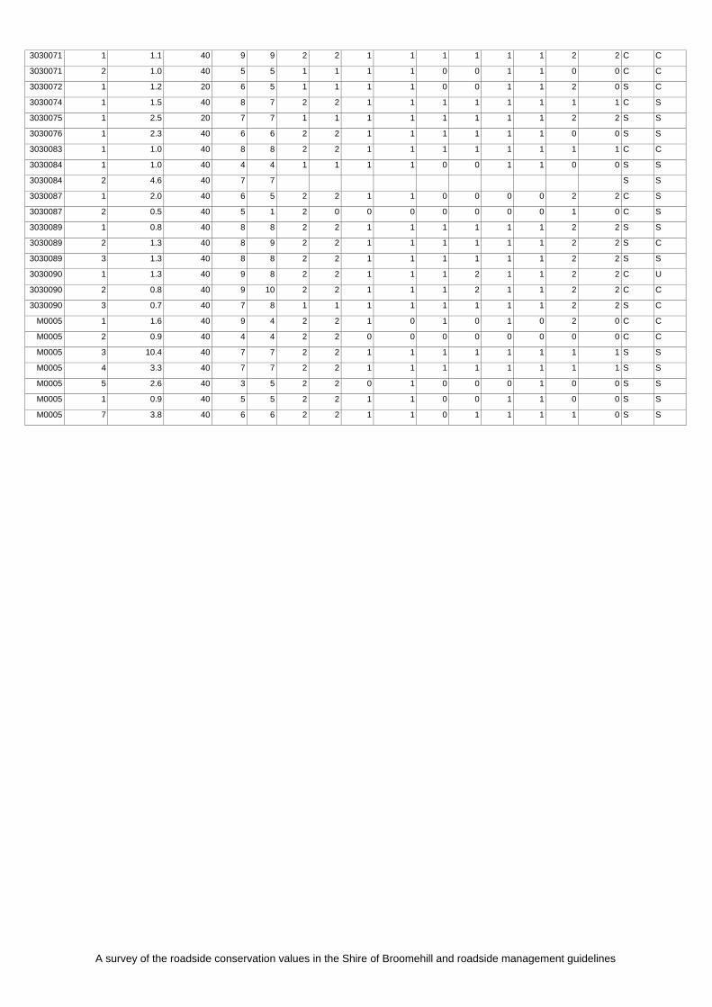
APPENDIX 3
Raw data used to calcuSHIRE_#
D ANSECTIO_# LENGTH
ESERVWIDTH (m)
CONS ALU(0-12)
NVEGETATION
EXTENT OF VEGETATION
NUM R OFSPECIES
WEEDS V E AS BIOLOGICAL CORRIDOR
DJO G LANDUSE
ROAD_#
N SECTION
(km)
R E . V E ATIVE BE ALU A ININ
LEFT RIGT
LEFT RIGH LEFT RIGHT LEFT RIGH LEFT RIGHT LEFT RIGHT FT H T T LE RIGHT
3030001 1 3.7 40 5 5 2 2 0 0 0 0 0 0 1 1 C C
3030001 2 0.4 60 7 7 1 1 1 1 1 1 1 1 1 1 C C
3030001 3 2.4 40 3 3 1 1 0 0 0 0 0 0 0 0 C C
3030001 4 7.7 40 7 7 1 1 1 1 1 1 1 1 2 2 S S
3030001 5 2.3 60 6 6 1 1 1 1 1 1 1 1 1 1 S S
3030001 6 2.2 40 7 7 1 1 1 1 1 1 1 1 1 1 C C
3030001 7 0.6 40 7 7 2 2 1 1 1 1 1 1 2 2 U U
3030001 8 4.3 40 6 6 1 1 1 1 1 1 1 1 1 1 S S
3030001 9 2.3 40 8 8 2 2 1 1 1 1 1 1 2 2 S S
3030001 10 3.6 40 5 5 1 1 1 1 1 1 1 1 0 0 S S
3030001 11 2.5 40 5 5 1 1 1 1 1 1 1 1 0 0 S S
3030002 1 1.1 40 7 6 2 2 1 1 1 1 1 1 1 0 S S
3030002 2 7.1 40 7 7 1 1 1 1 1 1 1 1 2 2 S S
3030003 1 0.5 40 5 5 1 1 1 1 0 0 1 1 0 0 C C
3030003 2 4.5 40 7 8 2 2 1 1 1 1 1 1 1 2 S S
3030003 3 1.4 40 4 5 1 1 1 1 0 0 1 1 0 1 S S
3030003 4 1.0 40 6 6 2 2 1 1 1 1 1 1 0 0 S S
3030003 5 2.0 40 6 8 2 2 1 1 1 1 1 1 0 1 S C
3030003 6 5.5 40 8 8 2 2 1 1 1 2 1 1 2 2 S U
3030003 7 1.5 40 6 6 2 2 1 1 1 1 1 1 0 0 S S
3030003 8 0.9 40 8 8 2 2 1 1 1 1 1 1 2 2 S S
3030003 9 0.8 40 5 5 1 1 1 1 0 0 1 1 2 2 U U
3030003 10 1.9 40 8 7 2 2 1 1 1 1 1 1 1 1 C S
3030003 11 1.4 40 5 5 1 1 1 1 0 0 1 1 0 0 C C
3030003 12 0.7 40 1 2 0 0 0 0 0 0 0 0 0 0 S C
3030003 13 0.4 40 4 5 1 1 1 1 0 0 1 1 0 1 S S
3030004 1 3.7 40 7 7 S S
3030005 1 1.4 40 8 8 2 2 1 1 1 1 1 1 1 1 C C
3030005 2 1.1 40 8 8 2 2 1 1 1 1 1 1 1 1 C C
3030005 3 1.9 40 9 9 2 2 1 1 1 1 1 1 2 2 C C
3030005 4 0.7 40 8 8 2 2 1 1 1 1 1 1 1 1 C C
3030005 5 0.8 40 4 4 2 2 0 0 0 0 0 0 0 0 C C
3030005 6 2.3 40 9 9 2 2 1 1 1 1 1 1 2 2 C C
3030005 7 14.1 40 9 9 2 2 1 1 1 1 1 1 2 2 C C
3030005 8 0.4 40 7 7 2 2 1 1 1 1 1 1 0 0 C C
3030005 9 3.6 40 9 9 2 2 1 1 1 1 1 1 2 2 C C
3030005 10 1.3 40 7 7 1 1 1 1 1 1 1 1 1 1 C C
3030006 1 2.9 40 5 5 1 1 1 1 0 0 1 1 0 0 C C
3030006 2 1.5 40 5 5 1 2 1 0 0 0 1 0 0 1 C C
3030006 3 0.5 40 6 8 2 2 0 1 1 1 0 1 1 1 C C
3030006 4 0.7 40 4 8 1 2 0 1 0 1 0 1 1 1 C C
3030006 5 2.4 40 8 8 2 2 1 1 1 1 1 1 1 1 C S
3030007 1 0.5 40 9 9 2 2 1 1 1 1 1 1 2 2 C C
3030007 2 0.4 40 7 7 2 2 1 1 1 1 1 1 2 2 U U
3030007 3 6.3 40 9 8 2 2 1 1 1 1 1 1 2 2 C S
3030007 4 1.0 40 9 9 2 2 1 1 1 1 1 1 2 2 C C
3030007 5 0.9 60 9 6 2 1 1 1 1 0 1 1 2 0 C C
3030007 6 0.8 40 8 5 2 1 1 1 1 0 1 1 1 0 C C

A survey of the roadside conservation values in the Shire of Broomehill and roadside management guidelines
3030007 7 1.3 40 8 9 2 2 1 1 1 1 1 1 2 2 S C
3030007 8 0.6 40 3 3 1 1 0 0 0 0 0 0 0 0 C C
3030007 9 1.2 40 4 4 1 1 1 1 0 0 1 1 0 0 S S
3030007 10 1.1 40 8 8 2 2 1 1 1 1 1 1 1 1 C C
3030008 1 1.1 40 3 4 1 1 0 0 0 0 0 0 0 1 C C
3030008 2 1.0 40 9 6 2 2 1 1 1 0 1 0 2 1 C C
3030008 3 1.5 40 9 3 2 1 1 0 1 0 1 0 2 0 C C
3030008 4 1.5 40 8 5 2 2 1 0 1 0 1 0 1 1 C C
3030008 5 3.4 40 7 8 2 2 0 1 1 1 0 1 2 2 C S
3030008 6 2.1 40 6 8 2 2 0 1 1 1 0 1 2 2 S S
3030008 7 1.9 40 5 8 1 2 0 1 1 1 0 1 1 2 C S
3030008 8 10.0 40 7 9 2 2 0 1 1 1 0 1 2 2 C C
3030008 9 2.4 40 6 9 2 2 1 1 0 1 1 1 1 2 S C
3030009 1 3.4 40 8 6 2 2 1 1 1 1 1 1 2 0 S S
3030009 2 1.5 40 3 3 2 2 0 0 0 0 0 0 0 0 S S
3030009 3 4.5 20 9 9 2 2 1 1 1 1 1 1 2 2 C C
3030010 1 2.2 40 9 9 2 2 1 1 1 1 1 1 2 2 C C
3030010 2 0.9 40 9 9 2 2 1 1 1 1 1 1 2 2 C C
3030010 3 2.0 40 9 9 2 2 1 1 1 1 1 1 2 2 C C
3030010 4 1.4 40 9 9 2 2 1 1 1 1 1 1 2 2 C C
3030010 5 2.4 40 9 9 2 2 1 1 1 1 1 1 2 2 C C
3030010 6 4.3 20 8 8 2 2 1 1 1 1 1 1 2 2 S S
3030011 1 1.8 40 8 8 2 2 2 2 1 1 1 1 1 0 S C
3030011 2 0.7 40 8 8 2 2 2 2 1 1 1 1 0 0 C C
3030011 3 2.1 40 8 9 2 2 1 1 1 1 1 1 1 2 C C
3030011 4 2.9 40 9 9 2 2 1 1 1 1 1 1 2 2 C C
3030011 5 2.2 40 9 9 2 2 1 1 1 1 1 1 2 2 C C
3030011 6 0.5 40 6 6 1 1 1 1 0 0 2 2 1 1 S S
3030011 7 1.7 40 8 7 2 2 1 1 1 1 1 1 1 1 C S
3030012 1 0.5 40 6 4 1 1 1 1 0 0 1 1 2 0 S S
3030012 2 0.7 40 1 4 0 1 0 1 0 0 0 1 0 0 S S
3030012 3 7.4 40 4 5 1 1 1 1 0 0 1 1 0 1 S S
3030015 1 2.1 40 7 3 2 1 1 0 0 0 1 0 1 0 C C
3030015 2 1.9 40 9 8 2 2 1 1 1 1 1 1 2 2 C S
3030015 3 0.8 40 3 5 0 1 0 1 0 0 0 1 1 1 C S
3030015 4 0.7 40 4 3 1 0 0 0 0 0 0 0 1 1 C C
3030016 1 0.4 40 8 8 2 2 1 1 1 1 1 1 1 1 C C
3030016 2 0.7 40 3 5 1 1 0 1 0 0 0 1 0 0 C C
3030016 3 1.6 40 8 8 2 2 1 1 1 1 1 1 1 1 C C
3030016 4 1.4 40 4 4 2 2 0 0 0 0 0 0 0 0 C C
3030016 5 3.4 40 8 8 2 2 1 1 1 1 1 1 1 1 C C
3030016 6 0.8 40 3 2 1 0 0 0 0 0 0 0 0 0 C C
3030016 7 0.5 40 7 8 2 2 1 1 0 0 1 1 1 2 C C
3030017 1 2.6 40 7 8 2 2 1 1 1 1 1 1 1 1 S C
3030017 2 2.8 40 8 8 2 2 1 1 1 1 1 1 2 2 S S
3030017 3 4.2 40 8 8 1 1 1 1 1 1 1 1 2 2 C C
3030017 4 1.5 40 9 9 2 2 1 1 1 1 1 1 2 2 C C
3030017 5 1.0 40 9 9 2 2 1 1 1 1 1 1 2 2 C C
3030017 6 2.1 40 9 9 2 2 1 1 1 1 1 1 2 2 C C
3030017 7 1.2 40 7 7 2 2 1 1 0 0 1 1 1 1 C C
3030017 8 1.8 40 5 10 1 2 1 2 0 2 1 2 0 2 C U
3030018 1 1.1 40 7 9 2 2 1 1 1 1 1 1 0 2 C C
3030018 2 1.9 40 7 8 2 2 1 1 1 1 1 1 0 1 C C
3030018 3 1.8 40 4 4 1 1 0 0 1 1 0 0 0 0 C C
3030018 4 8.5 20 8 8 2 2 1 1 1 1 1 1 2 2 S S
3030018 5 3.3 20 9 9 2 2 1 1 1 1 1 1 2 2 C C
3030018 6 1.5 40 9 9 2 2 1 1 1 1 1 1 2 2 C C

A survey of the roadside conservation values in the Shire of Broomehill and roadside management guidelines
3030018 7 2.2 40 9 9 2 2 1 1 1 1 1 1 2 2 C C
3030020 1 0.5 40 10 10 2 2 2 2 2 2 2 2 2 2 U U
3030020 2 0.3 40 9 12 2 2 1 2 1 2 1 2 2 2 C C
3030020 3 1.8 40 9 9 2 2 1 1 1 1 1 1 2 2 C C
3030020 4 1.1 20 9 9 2 2 1 1 1 1 1 1 2 2 C C
3030021 1 0.7 40 10 10 2 2 2 2 2 2 2 2 2 2 U U
3030021 2 1.3 40 8 8 2 2 1 1 1 1 1 1 1 2 C S
3030021 3 0.3 40 2 5 0 2 0 1 0 0 0 1 0 1 C U
3030021 4 4.2 40 10 10 2 2 1 1 2 2 1 1 2 2 C C
3030021 5 3.7 40 9 9 2 2 1 1 2 2 1 1 2 2 S S
3030022 1 1.0 40 6 10 2 2 1 2 1 2 0 2 1 2 S U
3030022 2 0.5 40 9 9 2 2 2 1 1 1 0 1 2 2 C C
3030022 3 2.1 40 8 9 2 2 1 1 1 1 1 1 2 2 S C
3030022 4 2.0 40 7 8 2 2 0 1 1 1 0 1 2 2 C S
3030023 1 5.9 20 9 9 2 2 1 1 1 1 1 1 2 2 C C
3030023 2 0.6 40 5 5 2 2 0 0 1 1 0 0 0 0 C C
3030023 3 1.2 40 9 9 2 2 1 1 1 1 1 1 2 2 C C
3030023 4 1.2 20 8 7 2 2 1 1 1 1 1 1 2 2 S U
3030023 5 3.9 20 8 8 2 2 1 1 1 1 1 1 2 2 S S
3030024 1 2.1 40 6 7 2 2 1 1 1 1 1 1 0 1 S S
3030024 2 3.7 40 6 6 1 1 1 1 1 1 1 1 1 1 S S
3030027 1 0.4 40 2 2 0 0 0 0 0 0 0 0 0 0 C C
3030027 2 1.5 40 4 5 1 1 1 1 0 0 1 1 0 0 S C
3030027 3 0.8 40 6 6 2 2 1 1 1 1 1 1 0 0 S S
3030027 4 1.8 40 8 8 2 2 1 1 1 1 1 1 1 1 C C
3030028 1 5.6 40 8 8 2 2 0 0 2 2 0 0 2 2 C C
3030028 2 0.7 40 10 11 2 2 2 2 1 1 2 2 1 2 C C
3030028 3 1.3 40 9 8 2 2 1 1 1 1 1 1 2 2 C S
3030029 1 1.2 40 2 3 1 1 0 0 0 0 0 0 0 0 S C
3030029 2 3.1 40 3 2 1 1 0 0 0 0 0 0 0 0 C S
3030030 1 2.5 40 3 3 1 1 0 0 0 0 0 0 0 0 C C
3030030 2 3.1 40 5 5 1 1 1 1 0 0 1 1 1 0 S C
3030030 3 0.4 40 7 5 2 1 1 1 1 0 1 1 1 1 S S
3030030 4 0.5 40 3 3 1 1 0 0 0 0 0 0 0 0 C C
3030030 5 2.1 40 9 9 2 2 1 1 1 1 1 1 2 2 C C
3030031 1 0.8 40 9 9 2 2 1 1 1 1 1 1 2 2 C C
3030031 2 0.6 40 8 7 2 2 1 1 1 0 1 1 1 1 C C
3030031 3 0.5 40 9 7 2 1 1 1 1 0 1 1 2 2 C C
3030031 4 0.6 40 3 4 1 1 0 0 0 0 0 0 0 1 C C
3030031 5 0.5 40 8 8 2 2 1 1 1 1 1 1 1 1 C C
3030031 6 0.3 40 2 2 0 0 0 0 0 0 0 0 0 0 C C
3030031 7 1.7 40 6 6 1 1 1 1 1 1 1 1 0 0 C C
3030036 1 0.7 40 3 3 1 1 0 0 0 0 0 0 0 0 C C
3030036 2 0.7 40 11 3 2 1 2 0 1 0 2 0 2 0 C C
3030036 3 1.6 40 9 9 2 2 1 1 1 1 1 1 2 2 C C
3030036 4 0.5 40 4 5 2 2 0 0 0 1 0 0 0 0 C C
3030036 5 1.4 40 9 9 2 2 1 1 1 1 1 1 2 2 C C
3030037 1 2.5 40 8 8 2 2 1 1 1 1 1 1 1 1 C C
3030037 2 2.4 40 6 9 2 2 0 1 1 1 0 1 1 2 C C
3030038 1 1.2 40 8 8 2 2 1 1 1 1 1 1 1 1 C C
3030038 2 0.3 40 5 5 1 1 1 1 0 0 1 1 0 0 C C
3030038 3 0.7 40 2 8 0 2 0 1 0 1 0 1 0 1 C C
3030038 4 0.3 40 6 3 2 1 1 0 0 0 1 0 0 0 C C
3030038 5 0.9 40 3 5 1 1 0 1 0 0 0 1 0 0 C C
3030038 6 1.2 40 8 8 2 2 1 1 1 1 1 1 1 1 C C
3030039 1 1.1 40 8 8 2 2 1 1 1 1 1 1 1 1 C C
3030039 2 0.3 40 5 5 2 2 0 0 0 0 0 0 1 1 C C

A survey of the roadside conservation values in the Shire of Broomehill and roadside management guidelines
3030039 3 0.6 40 8 7 2 2 1 1 1 1 1 1 1 1 C S
3030039 4 0.5 40 7 5 2 2 1 1 0 0 1 1 1 0 C S
3030040 1 4.2 40 8 8 2 2 1 1 1 1 1 1 2 2 S S
3030040 2 0.5 40 7 7 2 2 1 1 1 1 0 0 2 2 S S
3030040 3 0.7 40 8 8 2 2 1 1 1 1 1 1 1 1 C C
3030041 1 1.3 40 4 3 1 1 1 0 0 0 1 0 0 0 S C
3030041 2 1.5 60 6 5 1 1 1 1 0 0 1 1 1 1 C S
3030042 1 1.1 40 9 9 2 2 1 1 1 1 1 1 2 2 C C
3030042 2 1.4 40 9 9 2 2 1 1 1 1 1 1 2 2 C C
3030042 3 2.6 40 9 8 2 2 1 1 1 1 1 1 2 2 C S
3030042 4 0.8 40 9 9 2 2 1 1 1 1 1 1 2 2 C C
3030042 5 0.6 40 9 8 2 2 1 1 1 1 1 1 2 2 C S
3030042 6 1.0 40 8 8 2 2 1 1 1 1 1 1 2 2 S S
3030043 1 0.4 40 10 11 2 2 2 2 1 1 2 2 2 3 S C
3030043 2 0.8 40 6 7 2 2 1 1 1 1 1 1 0 0 S C
3030043 3 0.7 40 8 8 2 2 2 2 1 1 2 2 0 0 S S
3030043 4 1.6 40 6 7 2 2 1 1 0 0 1 1 0 1 C C
3030043 5 0.6 60 6 9 2 2 1 1 1 1 1 1 0 2 S C
3030043 6 1.2 60 7 8 2 2 1 1 0 1 1 1 1 2 C R
3030044 1 2.3 40 8 3 2 2 1 0 1 0 1 0 1 0 S S
3030045 1 3.1 40 8 8 2 2 1 1 1 1 1 1 2 2 S S
3030045 2 0.8 40 8 8 2 2 1 1 1 1 1 1 2 2 S S
3030046 1 2.7 40 8 9 2 2 1 1 1 1 1 1 2 2 S C
3030047 1 4.3 40 8 8 2 2 1 1 1 1 1 1 2 2 S S
3030047 2 0.8 40 8 8 2 2 1 1 1 1 1 1 2 2 S S
3030048 1 1.7 40 8 8 2 2 1 1 1 1 1 1 2 1 S C
3030048 2 0.8 40 8 8 2 2 1 1 1 1 1 1 2 2 S S
3030048 3 4.1 40 9 9 2 2 1 1 2 2 1 1 2 2 S S
3030049 1 1.3 20 7 7 2 2 1 1 1 1 1 1 1 1 S S
3030049 2 2.0 20 9 9 2 2 1 1 1 1 1 1 2 2 C C
3030050 1 1.3 40 7 6 1 1 1 1 1 1 1 1 1 0 C C
3030050 2 0.7 40 7 8 2 2 1 1 1 1 1 1 0 1 C C
3030050 3 2.9 40 10 10 2 2 1 1 2 2 1 1 2 2 C C
3030054 1 2.6 60 11 11 2 2 2 2 2 2 2 2 2 2 S C
3030054 2 0.9 60 10 12 2 2 2 2 2 2 2 2 2 2 U C
3030055 1 2.5 40 8 8 2 2 1 1 1 1 1 1 2 2 S S
3030055 2 5.3 40 5 7 1 1 0 1 1 1 0 1 2 2 S S
3030057 1 0.7 20 2 2 1 1 0 0 0 0 0 0 0 0 S S
3030057 2 0.8 20 3 3 1 1 0 0 0 0 0 0 0 0 C C
3030057 3 1.0 20 5 6 1 1 1 1 1 1 1 1 0 0 S C
3030059 1 2.6 40 7 7 1 1 1 1 1 1 1 1 2 2 S S
3030060 1 1.8 40 5 7 1 1 1 1 1 1 1 1 0 2 S S
3030061 1 2.9 40 6 6 1 1 1 1 0 0 1 1 2 2 S S
3030064 1 2.6 40 6 6 1 1 1 1 0 0 1 1 1 1 C C
3030065 1 0.4 40 8 8 2 2 1 1 1 1 1 1 1 1 C C
3030065 2 0.5 40 5 6 1 1 1 1 0 0 1 1 0 1 C C
3030065 3 0.9 40 10 10 2 2 2 2 1 1 2 2 1 1 C C
3030066 1 1.1 40 8 9 2 2 1 1 2 2 1 1 2 2 U R
3030066 2 0.8 40 9 9 2 2 1 1 1 2 1 1 2 2 C R
3030066 3 2.2 40 9 10 2 2 2 1 2 2 1 1 2 2 S R
3030066 4 1.1 40 9 8 2 2 1 1 1 1 1 1 2 2 C R
3030069 1 1.4 40 9 9 2 2 1 1 1 1 1 1 2 2 C C
3030069 2 3.9 60 8 9 2 2 1 1 1 1 1 1 2 2 S C
3030069 3 1.1 60 7 9 2 2 1 1 1 1 1 1 2 2 U C
3030069 4 0.6 60 7 8 2 2 1 1 1 1 1 1 2 2 U C
3030069 5 0.7 40 9 9 2 2 1 1 1 1 1 1 2 2 C C
3030070 1 1.1 40 8 8 2 2 1 1 1 1 1 1 2 2 S S
A survey of the roadside conservation values in the Shire of Broomehill and roadside management guidelines
3030071 1 1.1 40 9 9 2 2 1 1 1 1 1 1 2 2 C C
3030071 2 1.0 40 5 5 1 1 1 1 0 0 1 1 0 0 C C
3030072 1 1.2 20 6 5 1 1 1 1 0 0 1 1 2 0 S C
3030074 1 1.5 40 8 7 2 2 1 1 1 1 1 1 1 1 C S
3030075 1 2.5 20 7 7 1 1 1 1 1 1 1 1 2 2 S S
3030076 1 2.3 40 6 6 2 2 1 1 1 1 1 1 0 0 S S
3030083 1 1.0 40 8 8 2 2 1 1 1 1 1 1 1 1 C C
3030084 1 1.0 40 4 4 1 1 1 1 0 0 1 1 0 0 S S
3030084 2 4.6 40 7 7 S S
3030087 1 2.0 40 6 5 2 2 1 1 0 0 0 0 2 2 C S
3030087 2 0.5 40 5 1 2 0 0 0 0 0 0 0 1 0 C S
3030089 1 0.8 40 8 8 2 2 1 1 1 1 1 1 2 2 S S
3030089 2 1.3 40 8 9 2 2 1 1 1 1 1 1 2 2 S C
3030089 3 1.3 2 2 S S 40 8 8 2 2 1 1 1 1 1 1
3030090 1 1.3 2 2 C U 40 9 8 2 2 1 1 1 2 1 1
3030090 2 0.8 2 2 C C 40 9 10 2 2 1 1 1 2 1 1
3030090 3 0.7 2 2 S C 40 7 8 1 1 1 1 1 1 1 1
M0005 1 1.6 2 0 C C 40 9 4 2 2 1 0 1 0 1 0
M0005 2 0.9 0 0 C C 40 4 4 2 2 0 0 0 0 0 0
M0005 3 10.4 1 1 S S 40 7 7 2 2 1 1 1 1 1 1
M0005 4 3.3 1 1 S S 40 7 7 2 2 1 1 1 1 1 1
M0005 5 2.6 40 3 5 2 2 1 0 0 0 1 0 0 S S 0
M0005 1 0.9 40 5 5 2 2 1 0 0 1 1 0 0 S S 1
M0005 7 3.8 40 6 6 2 2 1 0 1 1 1 1 0 S S 1

A survey of the roadside conservation values in the Shire of Broomehill and roadside management guidelines
Appe
4
ndix

A survey of the roadside conservation values in the Shire of Broomehill and roadside management guidelines
APPENDIX 4
Native plant species in the Shire of Broomehill
3
cteolata edifolia 3
curva ms
iana subsp. lehmanniana ubsp. miraculosa
illardiera bicolor var. bicolor Bossiaea eriocarpa Brachyscome ciliaris Brachyscome glandulosa Brachyscome perpusilla var. tenella Brachysema celsianum Bromus lanceolatus Caladenia cairnsiana Caladenia chapmanii ms Caladenia falcata Caladenia flava subsp. flava ms Caladenia hiemalis ms Caladenia longicauda subsp. eminens ms Caladenia multiclavia Caladenia reptans subsp. reptans ms Caladenia xantha ms Calytrix leschenaultii Calytrix tetragona Chamelaucium ciliatum Chamelaucium pauciflorum pauciflorum ms Chloanthes coccinea Choretrum glomeratum var. glomeratum Conostylis seorsiflora subsp. seorsiflora Conostylis setigera subsp. setigera Cryptandra nutans Cyanicula deformis ms Cyanicula gemmata ms Dampiera juncea Dillwynia sp.A Perth Flora(R.Coveny 8036) Dodonaea humifusa
Dryandra cuneata Dryandra mucronulata subsp. mucronulata Dryandra mucronulata subsp. retrorsa P1 Dryandra nivea subsp. nivea Dryandra stuposa Dryandra subpinnatifida var. imberbis P2 Echium plantagineum Erymophyllum tenellum Eucalyptus annulata Eucalyptus astringens subsp. astringens Eucalyptus decipiens subsp. chalara Eucalyptus hypochlamydea subsp. ecdysiastes ms Eucalyptus kondininensis Eucalyptus lehmannii Eucalyptus occidentalis Eucalyptus phaenophylla subsp. interjacens Eucalyptus phaenophylla subsp. phaenophylla Eucalyptus pluricaulis subsp. porphyrea Eucalyptus redacta subsp. thamnoides ms Eucalyptus spathulata Eucalyptus sporadica ms Eucalyptus suggrandis subsp. alipes Eucalyptus suggrandis subsp. suggrandis Eucalyptus wandoo subsp. wandoo Eucalyptus xanthonema subsp. xanthonema Gastrolobium calycinum Gastrolobium parviflorum Gastrolobium spinosum var. spinosum Gastrolobium trilobum Grevillea cirsiifolia P4 Helichrysum leucopsideum Hydrocotyle alata Hydrocotyle callicarpa Hydrocotyle diantha Hydrocotyle pilifera var. glabrata Jacksonia sternbergiana Juncus subsecundus Kennedia microphylla Laxmannia omnifertilis Lechenaultia formosa Lepidium rotundum Leptoceras menziesii Leptomeria pauciflora Leucopogon cymbiformis Leucopogon minutifolius Leucopogon obtusatus Leucopogon ozothamnoides Leucopogon polymorphus Lyginia barbata Marsilea drummondii Melaleuca strobophylla Melaleuca undulata Mirbelia dilatata Mirbelia ovata
Acacia chamaeleon Acacia erinacea Acacia errabunda ms PAcacia ferocior Acacia glaucoptera Acacia grisea P4 Acacia lasiocarpa Acacia lasiocarpa var. braAcacia lasiocarpa var. sAcacia lullfitziorum ms PAcacia microbotrya .Acacia paradoxa Acacia pulviniformis Acacia pycnantha Acacia pycnocephala Acacia restiacea Acacia sphacelata subsp. reAcacia stenoptera Allocasuarina lehmannAmyema miraculosa sAnigozanthos manglesii subsp. manglesii Astroloma serratifolium Banksia meisneri subsp. meisneri Beaufortia incana B

A survey of the roadside conservation values in the Shire of Broomehill and roadside management guidelines
Nemcia emarginata Olearia incondita Ophioglossum lusitanicum Oxalis purpurea Persicaria prostrata Podolepis gracilis Praecoxanthus aphyllus ms Prasophyllum gracile Ptilotus declinatus Ptilotus manglesii Regelia cymbifolia P4 Santalum acuminatum Solanum elaeagnifolium Sollya heterophylla Stylidium leptophyllum Stylidium piliferum Stylidium uniflorum Templetonia sulcata Tetraria capillaris Tetratheca virgata Thelymitra x macmillanii Thysanotus gageoides P2 Thysanotus tenellus Thysanotus triandrus Tricoryne elatior Ursinia anthemoides Verticordia lindleyi subsp. purpurea P4 Verticordia plumosa var. brachyphylla Wurmbea tenella