a vegetation and flora survey of the rio tinto rail duplication … 2008a... · a vegetation and...
TRANSCRIPT

A Vegetation and Flora
Survey of the Rio Tinto Rail
Duplication Project – Cape
Lambert to Emu Siding
Prepared for Rio Tinto Iron Ore
August 2008


A Vegetation and Flora Survey of the Rio Tinto Rail Duplication Project – Cape Lambert to Emu Siding
© Biota Environmental Sciences Pty Ltd 2008 ABN 49 092 687 119
Level 1, 228 Carr Place Leederville Western Australia 6007
Ph: (08) 9328 1900 Fax: (08) 9328 6138 Project No.: 470 Prepared by: M. Maier, B. Mathews, J. Fairhead Checked by: G. Humphreys Approved for Issue: M. Maier
This document has been prepared to the requirements of the client identified on the cover page and no representation is made to any third party. It may be cited for the purposes of scientific research or other fair use, but it may not be reproduced or distributed to any third party by any
physical or electronic means without the express permission of the client for whom it was prepared or Biota Environmental Sciences Pty Ltd.
This report has been designed for double-sided printing. Hard copies supplied by Biota are printed on recycled paper.
Cube:Current:470 (Rail Dup Cape Lambert to Emu):Doc:Flora:470_flora_v3.doc 3

A Vegetation and Flora Survey of the Rio Tinto Rail Duplication Project – Cape Lambert to Emu Siding
4 Cube:Current:470 (Rail Dup Cape Lambert to Emu):Doc:Flora:470_flora_v3.doc

A Vegetation and Flora Survey of the Rio Tinto Rail Duplication Project – Cape Lambert to Emu Siding
Cube:Current:470 (Rail Dup Cape Lambert to Emu):Doc:Flora:470_flora_v3.doc 5
A Vegetation and Flora Survey of the Rio Tinto Rail
Duplication Project – Cape Lambert to Emu Siding
Contents
1.0 Summary 9 1.1 Background 9 1.2 Methodology 9 1.3 Vegetation 9 1.4 Flora 11
2.0 Background 13 2.1 Background to the Project 13 2.2 Scope and Objectives of this Study 13
3.0 Study Methodology 15 3.1 Desktop Review 15 3.2 Botanical Survey Team and Field Survey Timing 15 3.3 Vegetation Description and Mapping 16 3.4 Assessment of Floristic Quadrats 17 3.5 Searches for Rare Flora and Weeds 17 3.6 Specimen Identification, Nomenclature and Data Entry 18 3.7 Limitations of this Study 18
4.0 Existing Environment 21 4.1 IBRA Bioregion and Subregion 21 4.2 Conservation Reserves in the Locality 21 4.3 Land Systems of the Study Area 22 4.4 Beard’s Vegetation Mapping 23 4.5 Vegetation of Conservation Significance Known from the Locality 23 4.6 Flora of Conservation Significance Known from the Locality 24
5.0 Vegetation 27 5.1 Overview of Vegetation Types 27 5.2 Descriptions of Vegetation Types 27 5.3 Conservation Significance of the Vegetation Types 43
6.0 Flora 47 6.1 Overview of the Flora of the Study Area 47 6.2 Flora of Conservation Significance 49 6.3 Introduced Flora (Weeds) 51
7.0 Summary and Recommendations 57 7.1 Vegetation of Conservation Significance 57 7.2 Flora of Conservation Significance 57
8.0 Acknowledgements 58
9.0 References 59

A Vegetation and Flora Survey of the Rio Tinto Rail Duplication Project – Cape Lambert to Emu Siding
6 Cube:Current:470 (Rail Dup Cape Lambert to Emu):Doc:Flora:470_flora_v3.doc
Appendix 1 Framework for Conservation Significance Ranking of Communities and Species
Appendix 2 Vegetation Structural Classification and Condition Ranking Scale
Appendix 3 Vegetation Types, Priority Flora Locations and Weed Locations Recorded within the Study Area
Appendix 4 Raw Data from Quadrats and Relevés Assessed in the Study Area
Appendix 5 List of Flora Species Recorded from the Study Area
Appendix 6 Records of Weed Species from the Cape Lambert to Emu Siding Rail Corridor
Tables
Table 1.1: Summary of vegetation units of particular conservation significance identified during this study. 10
Table 1.2: Summary of Priority flora species recorded during this study. 11 Table 1.3: Weed species recorded from the Cape Lambert to Emu Siding rail
corridor. 12 Table 4.1: Land Systems (rangelands) within the proposed Cape Lambert to
Emu Siding rail corridor, and their wider representation in the Chichester and Roebourne subregions (source: van Vreeswyk et al. 2004). 22
Table 6.1: Plant families with the greatest number of native species in the project area. 48
Table 6.2: Genera with the greatest number of native species in the project area. 48
Table 6.3: Record of Nicotiana heterantha from the Cape Lambert to Emu Siding rail corridor. 49
Table 6.4: Records of Hibiscus brachysiphonius from the Cape Lambert to Emu Siding rail corridor. 50
Table 6.5: Summary of weed species recorded from the Cape Lambert to Emu Siding rail duplication corridor. 52
Table 7.1: Summary of vegetation units of particular conservation significance identified during this study. 57
Table 7.2: Summary of Priority flora species recorded during this study. 57
Figures
Figure 2.1: Locality plan of the PI 320 Rail Duplication Corridor between Cape Lambert and Emu Siding. 14
Figure 3.1: Monthly rainfall for the Roebourne recording station for the nine months preceding the current survey (data supplied by the WA Bureau of Meteorology). 16

A Vegetation and Flora Survey of the Rio Tinto Rail Duplication Project – Cape Lambert to Emu Siding
Cube:Current:470 (Rail Dup Cape Lambert to Emu):Doc:Flora:470_flora_v3.doc 7
Plates
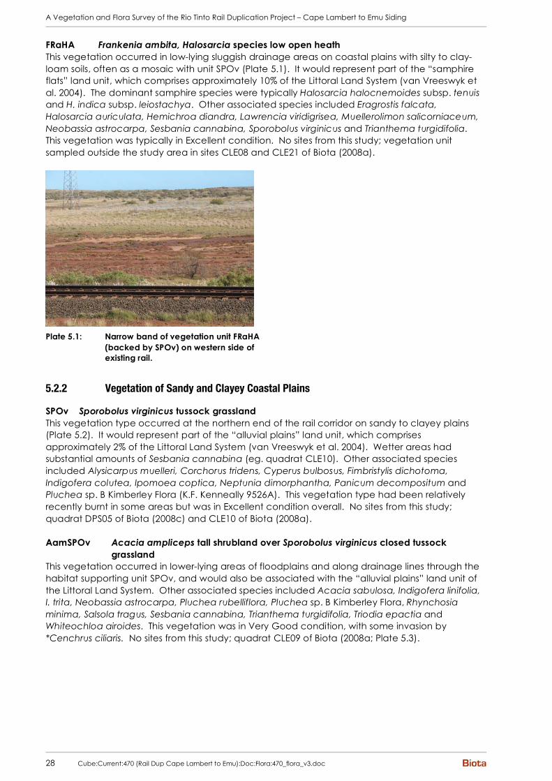
Plate 5.1: Narrow band of vegetation unit FRaHA (backed by SPOv) on western side of existing rail. 28
Plate 5.2: Vegetation unit SPOv (DPS05 of Biota 2008c). 29 Plate 5.3: Vegetation unit AamSPOv (CLE09 of Biota 2008a). 29 Plate 5.4: Vegetation unit AamAbTeCE. 30 Plate 5.5: Vegetation unit AcoGpTeTs. 30 Plate 5.6: Vegetation unit ApyAarTeTw (EMU01). 31 Plate 5.7: Vegetation unit ChApyAbTwTe (EMU19). 31 Plate 5.8: Vegetation unit ApyTw (EMU29). 32 Plate 5.9: Vegetation unit ApyTe (EMU27). 32 Plate 5.10: Vegetation unit ChAiTw on footslopes (EMU42). 32 Plate 5.11: Vegetation unit ChAiTw on hill (EMU-MJ). 32 Plate 5.12: Vegetation unit ApyAsyTe (EMU08). 33 Plate 5.13: Vegetation unit Ta (EMU39). 33 Plate 5.14: Vegetation unit TERcTw (EMU-MA). 34 Plate 5.15: Vegetation unit AcDIsEHsTwCEc (EMU-MC). 34 Plate 5.16: Vegetation unit ERAx (EMU11). 35 Plate 5.17: Patch of Eriachne flaccida open tussock grassland within
vegetation unit ERAx. 35 Plate 5.18: Vegetation unit H/G (EMU36). 36 Plate 5.19: Vegetation unit Tw/H (EMU37). 36 Plate 5.20: Vegetation unit AxTwERAxCEc (EMU23). 37 Plate 5.21: Vegetation unit AxTe. 37 Plate 5.22: Vegetation unit EcEvHAi (EMU-MH). 38 Plate 5.23: Vegetation unit EcEvERAf (EMU28). 38 Plate 5.24: Low open shrubland dominated by Halosarcia indica subsp.
leiostachya and Trianthema triquetra (EMU31). 38 Plate 5.25: Low open heath dominated by Stemodia grossa. 38 Plate 5.26: Vegetation unit EcAamCv. 39 Plate 5.27: Vegetation unit EvMg (EMU43). 40 Plate 5.28: Vegetation unit EvAtrTeCEc (EMU20). 40 Plate 5.29: Vegetation unit EvApyTwTeCEc (EMU25). 40 Plate 5.30: Vegetation unit TERcAarTw (EMU-MF). 41 Plate 5.31: Vegetation unit ChAtrEUaCHf (EMU14). 41 Plate 5.32: Vegetation unit ChAtuTeCE (EMU09). 42 Plate 5.33: Vegetation unit ChAtuTe. 42 Plate 5.34: Vegetation unit ChApyAaAbEUaTHt. 43 Plate 6.1: Flowers and habit of Nicotiana heterantha (photography by G.
Byrne; image used with the permission of the Western Australian Herbarium, Department of Environment and Conservation (http://florabase.calm.wa.gov.au/help/copyright); accessed on Wednesday, 06/08/08). 49
Plate 6.2: Mature plant of *Opuntia stricta. 53 Plate 6.3: Habit, and uni- and tri-foliate leaves of *Vitex trifolia var.
subtrisecta. 53 Plate 6.4: Dense *Aerva javanica growing along rail through the Harding
Dam floodout area (52 km chainage). 53

A Vegetation and Flora Survey of the Rio Tinto Rail Duplication Project – Cape Lambert to Emu Siding
8 Cube:Current:470 (Rail Dup Cape Lambert to Emu):Doc:Flora:470_flora_v3.doc
Plate 6.5: Deeply divided and lobed leaf and distinctively mottled fruit of *Citrullus colocynthis. 54
Plate 6.6: *Cucumis melo subsp. agrestis (foreground) with *Cucumis sp. (background). 55
Plate 6.7: *Cucumis sp.: (clockwise from top left): distinctly lobed leaves of *Cucumis sp. (foreground) compared to *Cucumis melo subsp. agrestis (background); leaves and unripe fruit; seeds; ripe fruit showing purplish blush. 55

A Vegetation and Flora Survey of the Rio Tinto Rail Duplication Project – Cape Lambert to Emu Siding
Cube:Current:470 (Rail Dup Cape Lambert to Emu):Doc:Flora:470_flora_v3.doc 9
1.0 Summary
1.1 Background
Rio Tinto Iron Ore seeks to duplicate or modify parts of its existing rail network from Cape Lambert Port to Juna Downs to accommodate the additional iron ore output from the expansion of existing mines and the development of new operations. This report details botanical studies used to assess the portion of the rail duplication project lying between Cape Lambert and Emu Siding on the existing Pilbara Iron Railway.
1.2 Methodology
The study comprised:
• review of existing information relevant to the study area, including searches of the Department of Environment and Conservation and WA Herbarium databases of rare flora records;
• description and mapping of vegetation types within the rail corridor;
• assessment of 44 standard (50x50m) flora recording quadrats and 12 relevés (unbounded flora survey sites comprising a similar area to a standard quadrat);
• opportunistic foot traverses through representative areas to search for flora of conservation significance and weed species, including targeted searches of particular habitats (eg. rockpiles, creeklines and cracking clays); note that the entire study area was not systematically searched for rare flora;
• collation of an overall list of flora species for the study area; and
• discussion of vegetation types and flora species of conservation significance, including broad management recommendations to minimise impacts.
The rail corridor was assessed between the 1st and 11th of April by five botanists from Biota (Jeni Alford, Justin Fairhead, Paul Hoffman, Rachel Warner and Michi Maier). Conditions at the time of survey were favourable for the collection of annual and cryptic perennial species, with numerous ephemeral species recorded.
1.3 Vegetation
1.3.1 Overall Vegetation Types
Forty-seven (47) vegetation types were identified within the Cape Lambert to Emu Siding Rail Duplication Corridor. Broadly these comprised;
• Small stands of mangal dominated by White Mangrove (Avicennia marina) interspersed with low open heaths dominated by Samphires and Frankenia on mudflats along the north-western edge of the corridor;
• Tussock grasslands of Marine Couch (Sporobolus virginicus) on sluggishly drained coastal plains;
• Open shrublands of Acacia ampliceps, A. bivenosa and/or A. coriacea subsp. coriacea over hummock grasslands of Triodia epactia and tussock grasslands of *Cenchrus species on coastal dune habitats;
• Acacia colei var. colei, Grevillea pyramidalis tall open shrubland over Triodia epactia, T. schinzii hummock grassland on sandplain at the northern end of the corridor;

A Vegetation and Flora Survey of the Rio Tinto Rail Duplication Project – Cape Lambert to Emu Siding
10 Cube:Current:470 (Rail Dup Cape Lambert to Emu):Doc:Flora:470_flora_v3.doc
• Open shrublands of various combinations of Acacia arida, A. bivenosa, A. inaequilatera, A. pyrifolia over hummock grasslands of Triodia wiseana and/or T. epactia on stony hills and plains throughout the corridor;
• Triodia angusta hummock grasslands on plains with a calcareous clay-loam substrate;
• Woodlands to tall shrublands dominated by Terminalia canescens or Acacia coriacea subsp. coriacea, Dichrostachys spicata and Ehretia saligna over open hummock grasslands of Triodia wiseana on rockpiles;
• Eragrostis xerophila tussock grasslands, annual grasslands and/or Triodia wiseana hummock grasslands interspersed with herblands, sometimes with an overstorey of Snakewood (Acacia xiphophylla), on heavy clay soils;
• Various vegetation types including low shrublands dominated by samphires or Stemodia grossa and grasslands dominated by Eragrostis falcata, often with scattered trees of River Red Gum (Eucalyptus camaldulensis) and Coolibahs (E. victrix), on the floodout areas from the Harding Dam;
• Riverine woodlands dominated by Eucalyptus camaldulensis, E. victrix and/or Terminalia canescens over various shrubs including Acacia ampliceps, A. pyrifolia, A. trachycarpa and Melaleuca glomerata over sedgelands, Triodia hummock grasslands and/or *Cenchrus tussock grasslands in major drainage features; and
• Low open woodlands of Hamersley Bloodwood (Corymbia hamersleyana) over dense tall shrublands of various species such as Acacia ancistrocarpa, A. bivenosa, A. coriacea subsp. pendens, A. pyrifolia and A. trachycarpa over Triodia hummock grasslands and/or tussock grasslands of *Cenchrus or native species in minor flowlines.
1.3.2 Conservation Significance of the Vegetation Types
While none of the vegetation types identified within the rail corridor are listed under the EPBC Act 1999, nor are any defined as Threatened Ecological Communities by the Department of Environment and Conservation, a number were identified as having particular conservation significance (Table 1.1). Two of the vegetation units (H/G and Tw/H) would comprise the “cracking clay communities of the Chichester Range” Priority Ecological Community (PEC), while riparian vegetation of the Harding River and other major drainages was also considered to be of High significance. Vegetation of Moderate significance was considered to include mangal (unit AVm), vegetation of cracking clays (principally unit ERAx) and rockpile vegetation (unit TERcTw and AcDIsEHsTwCEc). Disturbance to the vegetation types of High significance should be avoided, and strictly minimised if this is not possible. No non-essential infrastructure should be located in these habitats. Appropriate culverting will also be required where drainage systems are intersected. Disturbance to the vegetation types of Moderate significance should be strictly minimised.
Table 1.1: Summary of vegetation units of particular conservation significance identified during this study.
Vegetation Code Description Conservation Significance
H/G, Tw/H Annual herblands / grasslands and hummock grasslands on cracking clays of the Pyramid Land System
High (PEC)
EcAamCv, EvMg, EvAtrTeCEc, EvTERcApyTwTeCE, EvApyTwTeCE
Riparian vegetation of the Harding River system and other major drainages
High
AVm Mangrove vegetation dominated by Avicennia marina
Moderate
ERAx Eragrostis xerophila tussock grasslands on clay Moderate
TERcTw, AcDIsEHsTwCEc Rockpile vegetation Moderate

A Vegetation and Flora Survey of the Rio Tinto Rail Duplication Project – Cape Lambert to Emu Siding
Cube:Current:470 (Rail Dup Cape Lambert to Emu):Doc:Flora:470_flora_v3.doc 11
1.4 Flora
1.4.1 Overview of Flora
A total of 369 taxa of native vascular flora from 145 genera belonging to 57 families has been recorded from the Cape Lambert to Emu Siding project area (including the results from the 2008 survey work, together with the quadrats previously sampled in the area during the Cape Lambert Port B Expansion survey (Biota 2008a) and the Dampier Power Station Transmission Line study (Biota 2008c)). These numbers are within the expected range for a study area of this size in this locality.
1.4.2 Flora of Conservation Significance
No Declared Rare Flora species or flora species listed under the EPBC Act 1999 were recorded from the Cape Lambert to Emu Siding rail corridor, and none would be expected to occur. Two Priority flora species were recorded from the rail corridor as summarised in Table 1.2. Disturbance to these Priority flora populations should be avoided in the design and construction of the rail duplication, and clearing of the vegetation type/s supporting them should be minimised.
Table 1.2: Summary of Priority flora species recorded during this study.
Species Ranking Locations in Easting and Northing (WGS84)
Vegetation Type
Nicotiana heterantha Priority 1 509527 mE, 7675320 mN EcEvHAi (also potentially EcEvERAf and floodout mosaic)
509938 mE, 7698715 mN
510844 mE, 7691154 mN
Hibiscus brachysiphonius Priority 3
509536 mE, 7676500 mN
ERAx, AxTwERAxCEc, floodout mosaic
1.4.3 Introduced Flora (Weeds)
Seventeen weed species were recorded from the Cape Lambert to Emu Siding rail duplication corridor (Table 1.3). Most of these species are common and widespread weeds of the Pilbara, however some are only infrequently recorded in the region (eg. *Opuntia stricta, *Vitex trifolia var. subtrisecta and *Phyla nodiflora). One of the species is listed as a Declared Plant under the Agriculture and Related Resources Protection Act 1976: all Prickly Pears (*Opuntia species) are listed as P1 (movement is prohibited) and P2 (aim is to eradicate infestation) for the Pilbara. While not listed as Declared Plants, Kapok Bush (*Aerva javanica) and the two *Cenchrus species are considered to be serious environmental weeds.

A Vegetation and Flora Survey of the Rio Tinto Rail Duplication Project – Cape Lambert to Emu Siding
12 Cube:Current:470 (Rail Dup Cape Lambert to Emu):Doc:Flora:470_flora_v3.doc
Table 1.3: Weed species recorded from the Cape Lambert to Emu Siding rail corridor.
Species (Common Name) Distribution through the Study Area
*Aerva javanica (Kapok Bush) widespread, mainly close to existing disturbance areas
*Cenchrus ciliaris (Buffel Grass) widespread; particularly abundant near existing disturbance areas, on coastal dunes and along creeklines
*Cenchrus setiger (Birdwood Grass) widespread; particularly abundant near existing disturbance areas, on coastal dunes and along creeklines
*Citrullus colocynthis (Colocynth) central section of the corridor in the Harding Dam floodout area
*Cucumis melo subsp. agrestis (Ulcardo Melon)
central section of the corridor in the Harding Dam floodout area, Harding River itself and a tributary
*Cucumis sp. numerous records between the 16 km and 64 km chainages, mainly on clay or in creeklines
*Cynodon dactylon (Couch Grass) along creeklines and floodplains in the southern half of the corridor
*Echinochloa colona (Awnless Barnyard Grass)
in the central section of the corridor associated with the Harding River system
*Malvastrum americanum (Spiked Malvastrum)
scattered in creeklines between the 25 and 51 km chainages
*Opuntia stricta (Common Prickly Pear) a single record of 2 plants at the northern end of the corridor
*Passiflora foetida var. hispida (Stinking Passion Flower)
two records in the northern third of the corridor
*Phyla nodiflora (Lippia) one record in the central section of the corridor, in the Harding River
*Portulaca oleracea (Purslane) widespread throughout the corridor, including in apparently undisturbed areas
*Setaria verticillata (Whorled Pigeon Grass)
in the central section of the corridor, in the Harding River
*Sigesbeckia orientalis (Indian Weed) one record at the southern end of the corridor, in Western Creek
*Vachellia farnesiana (Mimosa Bush) 13 records between the 18 km and 40 km chainages, mainly on clayey plains
*Vitex trifolia var. subtrisecta (Three Leaved Chaste Tree)
1 plant at the northern end of the corridor

A Vegetation and Flora Survey of the Rio Tinto Rail Duplication Project – Cape Lambert to Emu Siding
Cube:Current:470 (Rail Dup Cape Lambert to Emu):Doc:Flora:470_flora_v3.doc 13
2.0 Background
2.1 Background to the Project
Rio Tinto Iron Ore seeks to duplicate or modify parts of its existing rail network from Cape Lambert Port to Juna Downs to accommodate the additional iron ore output from the expansion of existing mines and the development of new operations. The planned rail duplication complements Rio Tinto’s proposal to expand port facilities as part of its Cape Lambert Port B Development (Biota 2008a). A proposed provisional layout of the rail section from Cape Lambert to Emu Siding is shown in Figure 2.1.
2.2 Scope and Objectives of this Study
Biota Environmental Sciences (Biota) was commissioned to carry out a vegetation and flora survey of the Cape Lambert to Emu Siding rail corridor in April 2008. The survey was planned and implemented as far as practicable (no seasonal sampling component was possible in the timeframe) according to the Environmental Protection Authority (EPA) Position Statement No. 3 “Terrestrial Biological Surveys as an Element of Biodiversity Protection” (EPA 2002) and Guidance Statement No. 51 “Terrestrial Flora and Vegetation Surveys for Environmental Impact Assessment in Western Australia” (EPA 2004). The scope of the botanical survey was:
• to describe and map the vegetation types occurring within the study area;
• to identify any vegetation types of particular conservation significance;
• to document the suite of flora species occurring within the study area;
• to identify species of particular conservation significance, including Declared Rare Flora (DRF), Priority flora and other flora of interest; and
• to make recommendations for management of significant vegetation types and flora within the study area.
This report describes the methodology employed for this study, documents the findings of the field survey, and presents management recommendations for significant vegetation types and flora species. It is intended for use as a supporting document to the Environmental Impact Assessment process for the proposed project. The survey itself and this document are subject to certain limitations, outlined in Section 3.7.

A Vegetation and Flora Survey of the Rio Tinto Rail Duplication Project – Cape Lambert to Emu Siding
14 Cube:Current:470 (Rail Dup Cape Lambert to Emu):Doc:Flora:470_flora_v3.doc
Figure 2.1: Locality plan of the PI 320 Rail Duplication Corridor between Cape Lambert and Emu Siding.

A Vegetation and Flora Survey of the Rio Tinto Rail Duplication Project – Cape Lambert to Emu Siding
Cube:Current:470 (Rail Dup Cape Lambert to Emu):Doc:Flora:470_flora_v3.doc 15
3.0 Study Methodology
3.1 Desktop Review
3.1.1 Rare Flora Database Searches
A search of the DEC and WA Herbarium databases was commissioned in May 2008 for DRF and Priority flora recorded within an approximately 25 km buffer of the study area. The locations of the resulting records were investigated in ArcView to indicate populations within or in the vicinity of the study area (see Section 4.6).
3.1.2 Review of Published and Unpublished Reports
Various reports were reviewed to indicate botanical features of relevance to the current study area, including features of the IBRA subregions (May and McKenzie 2003; Section 4.1), Land Systems (van Vreeswyk et al. 2004; Section 4.3), and Threatened and Priority Ecological Communities (Section 4.5). Three reports from botanical surveys intersecting sections of the rail corridor were used to provide site-specific data:
• a survey of the Cape Lambert Port B Expansion area, which includes the northernmost 2 km section of the rail corridor (Biota 2008a);
• a survey of the Cape Lambert Substation, to the east of the 6 km chainage on the Cape Lambert to Mesa J rail line (Biota 2008b); and
• a survey of the Dampier Power Station Transmission Line Corridor, which extends from Dampier east to the Cape Lambert Substation, crossing the current rail corridor between the 6 km and 9 km chainages on the Cape Lambert to Mesa J rail line (Biota 2008c).
Some previous vegetation mapping has also been conducted over the southern section of the rail corridor which lies within the Millstream-Chichester National Park (Trudgen undated). Unfortunately the digital mapping supplied for this area was not attributed, however hard copy plans were available. The broad regional Pilbara Biological Survey being undertaken by the DEC includes floristic survey quadrats within the current study area, however the data from these are not yet available.
3.2 Botanical Survey Team and Field Survey Timing
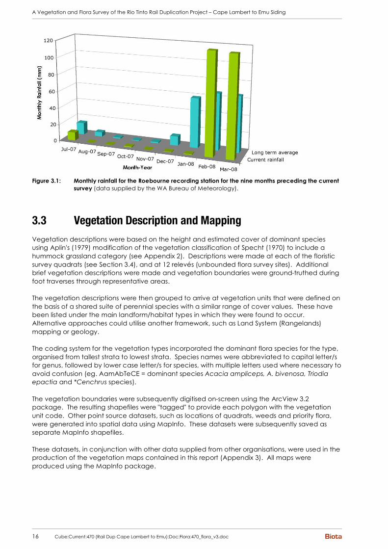
The Cape Lambert to Emu Siding rail corridor was assessed between the 1st and 11th of April by five botanists from Biota (Jeni Alford, Justin Fairhead, Paul Hoffman, Rachel Warner and Michi Maier). The closest official meteorological recording station to the study area is at Roebourne (on the North West Coastal Highway, approximately 4.5 km east of the existing Cape Lambert to Mesa J rail line). Data from this station indicate that considerable rain (well above average) fell in the two months prior to the current field survey, and that this followed an extended period of negligible rainfall (Figure 3.1). Conditions at the time of survey were favourable for the collection of annual and cryptic perennial species, with numerous ephemeral species recorded.
A Vegetation and Flora Survey of the Rio Tinto Rail Duplication Project – Cape Lambert to Emu Siding
16 Cube:Current:470 (Rail Dup Cape Lambert to Emu):Doc:Flora:470_flora_v3.doc
Figure 3.1: Monthly rainfall for the Roebourne recording station for the nine months preceding the current
survey (data supplied by the WA Bureau of Meteorology).
3.3 Vegetation Description and Mapping
Vegetation descriptions were based on the height and estimated cover of dominant species using Aplin's (1979) modification of the vegetation classification of Specht (1970) to include a hummock grassland category (see Appendix 2). Descriptions were made at each of the floristic survey quadrats (see Section 3.4), and at 12 relevés (unbounded flora survey sites). Additional brief vegetation descriptions were made and vegetation boundaries were ground-truthed during foot traverses through representative areas. The vegetation descriptions were then grouped to arrive at vegetation units that were defined on the basis of a shared suite of perennial species with a similar range of cover values. These have been listed under the main landform/habitat types in which they were found to occur. Alternative approaches could utilise another framework, such as Land System (Rangelands) mapping or geology. The coding system for the vegetation types incorporated the dominant flora species for the type, organised from tallest strata to lowest strata. Species names were abbreviated to capital letter/s for genus, followed by lower case letter/s for species, with multiple letters used where necessary to avoid confusion (eg. AamAbTeCE = dominant species Acacia ampliceps, A. bivenosa, Triodia epactia and *Cenchrus species). The vegetation boundaries were subsequently digitised on-screen using the ArcView 3.2 package. The resulting shapefiles were "tagged" to provide each polygon with the vegetation unit code. Other point source datasets, such as locations of quadrats, weeds and priority flora, were generated into spatial data using MapInfo. These datasets were subsequently saved as separate MapInfo shapefiles. These datasets, in conjunction with other data supplied from other organisations, were used in the production of the vegetation maps contained in this report (Appendix 3). All maps were produced using the MapInfo package.

A Vegetation and Flora Survey of the Rio Tinto Rail Duplication Project – Cape Lambert to Emu Siding
Cube:Current:470 (Rail Dup Cape Lambert to Emu):Doc:Flora:470_flora_v3.doc 17
3.4 Assessment of Floristic Quadrats
The locations of the 44 detailed flora recording quadrats established in 2008 were chosen to represent the main vegetation types occurring within the rail corridor. The quadrats were uniquely numbered, from EMU01 to EMU47 (EMU45 and EMU46 were not used). Twelve relevés (unbounded flora survey sites comprising a similar area to a standard quadrat) were also sampled; these were labelled EMU-MA to EMU-MK, and EMU-JAA. In addition to these sampling sites, data were extracted from five quadrats established within the rail corridor during the Cape Lambert Port B Expansion study (CLE09, CLE10, CLE11, CLE15 and CLE16; Biota 2008a) and two quadrats (MWS02 and DPS05) assessed in the area during the Dampier Power Station Transmission Line study (Biota 2008c). All sites were established and assessed using the following methodology. Quadrats were typically 50 m x 50 m, as this size gives a good sample of flora presence in the Pilbara. It also gives a good indication of the shrub and grass layer vegetation structure for most vegetation types in the Pilbara that occur in 'uniform' habitats (eg. plains and hillslopes, where vegetation stands are typically greater than this quadrat size). Quadrat shape and/or size were adjusted as necessary to fit smaller or oddly shaped habitats (eg. flowlines). Most quadrats were permanently marked using steel fence droppers at three to four corners of the quadrat. An optical square and measuring tapes were used to ensure that the quadrat sides were correctly positioned. The following parameters were recorded for each quadrat (see Appendix 4):
1. Location: AMG coordinates recorded in WGS84 datum (within 1-2 m of GDA94) using a hand-held Global Positioning System (GPS), to an accuracy usually within 5 m; readings taken for all four corners of the quadrat;
2. Vegetation Description: Broad description based on the height and estimated cover of dominant species after Aplin's (1979) modification of the vegetation classification system of Specht (1970) (see Appendix 2);
3. Habitat: Description of landform and habitat;
4. Soil: Broad description of soil type and stony surface mantle;
5. Disturbance Details: Condition ranked according to the scale developed by Trudgen (1988) as shown in Appendix 2, considering evidence of grazing, physical disturbance, weed invasion, frequent fires etc. Note that fire effects are only considered as a negative impact if they are caused by repeated burning (such as that done for pastoral purposes). Fire is a natural and frequent process in the Pilbara to which the vegetation has adapted, and to class areas as being in poor condition simply because they have been recently burnt is misleading; and
6. Percentage Foliar Cover: Cover was estimated visually for each species. Estimates were made to the nearest percent where possible, or a range (eg. 5-10%) was used. '+' was used where only occasional individuals were present, with a cover of less than 1%.
Colour photographs of the vegetation at each site were taken using a digital camera.
3.5 Searches for Rare Flora and Weeds
Given the extent of the study area, the entire area could not be systematically searched for rare flora over the period of the field survey. Instead, representative foot traverses were walked through the main habitats to search for rare species and to indicate the level of weed presence. Particular habitats which are known to frequently support rare or habitat-restricted flora (eg. cracking clays, rockpiles, creeklines) were specifically targeted.

A Vegetation and Flora Survey of the Rio Tinto Rail Duplication Project – Cape Lambert to Emu Siding
18 Cube:Current:470 (Rail Dup Cape Lambert to Emu):Doc:Flora:470_flora_v3.doc
Any locations of rare flora were recorded using a GPS (WGS84 datum), together with an indication of the number of individuals present, the habitat and associated plant species. Voucher specimens were also collected for lodgement with the Western Australian Herbarium. Rare Flora Report Forms will be lodged with DEC for the Priority species found within the study area. Introduced flora were also recorded as part of this exercise, although not every location was recorded for widespread species (eg. *Cenchrus ciliaris, which was common along existing infrastructure areas). Any additional native flora species that had not been previously recorded in the area by the survey team were also noted during these traverses. All records of rare flora and weeds are displayed on the vegetation mapping in Appendix 3.
3.6 Specimen Identification, Nomenclature and Data Entry
Common species that were well known to the survey botanists were identified in the field. Voucher specimens of all other species were collected and assigned a unique number to facilitate tracking of data. These were pressed in the field, and dried in a drying oven. These vouchers were then identified by keying out, reference to appropriate publications, use of reference collections and comparison to the collections held at the Western Australian Herbarium. Most specimens were identified by botanists from Biota, with assistance from Malcolm Trudgen of M.E. Trudgen and Associates and Greg Guerin of the WA Herbarium for difficult plant groups. Specimens will be lodged with the Western Australian Herbarium for all taxa for which suitable material is available. Nomenclature was checked against the current listing of scientific names recognised by the Western Australian Herbarium and updated as necessary. The only outdated nomenclature retained was that relating to Cassia. This genus is currently recognised as Senna (see Randell 1989), however the older Cassia classification (Symon 1966) was perceived to be a more realistic level of separation of the taxa (eg. with taxa such as 'glutinosa' and 'pruinosa' recognised at specific rather than subspecific level). A more detailed discussion is contained in Trudgen and Casson (1998), while a comparison of the nomenclature under the two classifications is presented in Appendix 5.
3.7 Limitations of this Study
A number of limitations of the field survey and subsequent conservation assessments are discussed in the following section. These are factors that must be considered when reviewing and applying the results of this study. Despite these limitations, the field study and the subsequent analyses are believed to give a reasonable representation of the flora and vegetation values of the Cape Lambert to Emu Siding rail corridor. The main limitations of this study are as follows:
• Fungi and nonvascular flora (eg. algae, mosses and liverworts) were not specifically sampled.
• No quadrats were established in the southern 10 km of the study area as this section was inaccessible during the field survey due to construction of the Millstream Link road. This area was traversed at slow speed by vehicle in July 2008 to extend the vegetation mapping boundaries and was spot-sampled only.
• Although the field work was done at an appropriate time for detecting most ephemeral flora, some species (eg. annual daisies that would germinate mostly after late winter rains) would not have been present or identifiable at the time of survey. In addition, the entire study area was not systematically searched for rare flora. The species lists should therefore be taken as indicative rather than exhaustive.

A Vegetation and Flora Survey of the Rio Tinto Rail Duplication Project – Cape Lambert to Emu Siding
Cube:Current:470 (Rail Dup Cape Lambert to Emu):Doc:Flora:470_flora_v3.doc 19
• The vegetation units for this study were defined based on interpretation of aerial photography signatures combined with the site data and field mapping notes recorded during the field survey. As it was not possible to map areas outside the study area in this way, the distribution of these units outside the study area can only be inferred by their correlation with the Land Systems mapping prepared by the Department of Agriculture. This means that there is a level of uncertainty regarding the assessment of distribution of these vegetation types outside the current study area.
• Mapping was based on the latest available orthophotography, however this may not show recently constructed infrastructure. Delineation of currently disturbed areas may therefore be inaccurate for some areas.
• No floristic analysis has been conducted using the data from the quadrats and relevés from this study.
• This document contains only general management recommendations to address significant vegetation types and flora species.

A Vegetation and Flora Survey of the Rio Tinto Rail Duplication Project – Cape Lambert to Emu Siding
20 Cube:Current:470 (Rail Dup Cape Lambert to Emu):Doc:Flora:470_flora_v3.doc
This page intentionally blank.
A Vegetation and Flora Survey of the Rio Tinto Rail Duplication Project – Cape Lambert to Emu Siding
Cube:Current:470 (Rail Dup Cape Lambert to Emu):Doc:Flora:470_flora_v3.doc 21
4.0 Existing Environment
4.1 IBRA Bioregion and Subregion
The Interim Biogeographic Regionalisation for Australia (IBRA) recognises 85 bioregions (Environment Australia 2000). The current study area lies within the Pilbara bioregion. With increasing survey work, it is becoming apparent that the Pilbara is a major centre of biodiversity in Western Australia. This appears to be related to the region's diversity of geological, altitudinal and climatic elements, as well as its location. The Pilbara is a transitional zone between the floras of the Eyrean (central desert) and southern Torresian (tropical) bio-climatic regions, and contains elements of both floras (see for example van Leeuwen and Bromilow (2002) for a detailed discussion of the significance of the Hamersley Range). Similarly, the Pilbara is also a transitional zone for fauna. In 2003 in recognition of the high species diversity and high levels of endemism in the region, the Pilbara was nominated as one of 15 national biodiversity "hotspots" by the Minister for the Environment and Heritage (go to http://www.environment.gov.au/ biodiversity/hotspots/national-hotspots.html#14). The Pilbara bioregion is divided into four subregions1, described by Environment Australia (2000) as the four major components of the Pilbara Craton:
• Chichester (PIL1): Archaean granite and basalt plains supporting shrub steppes of Acacia pyrifolia over Triodia pungens hummock grasses, with Snappy Gum (Eucalyptus leucophloia) steppes occurring on the ranges;
• Fortescue Plains (PIL2): alluvial plains and river frontages with salt marsh, Mulga-bunch grass and short grass communities on alluvial plains and River Gum woodlands fringing drainage lines;
• Hamersley (PIL3): mountainous area of Proterozoic ranges and plateaux with low Mulga (Acacia aneura) woodland over bunch grasses on fine textured soils, and Snappy Gum over Triodia brizoides on the skeletal sandy soils of the ranges; and
• Roebourne Plains (PIL4): quaternary alluvial plains with a grass savanna and shrub steppe of Acacia translucens over Triodia pungens and marine alluvial flats with Samphire, Sporobolus and Mangal.
The majority of the study area lies within the Chichester subregion, with a small section (the Harding River and associated clayey plains) mapped as part of the Roebourne Plains subregion.
4.2 Conservation Reserves in the Locality
The southernmost 12 km section of the Cape Lambert to Emu Siding rail corridor lies within the A-class Millstream-Chichester National Park. While the corridor parallels the existing infrastructure exclusion through the Park, in some places it extends out more than 800 m from this easement. The Millstream Link section of the Dampier to Tom Price Road is also under construction through this exclusion corridor. There are also several C-class nature reserves on islands off the coast to the north-west of Cape Lambert, however they are not relevant given the nature of this project. The Pilbara bioregion is listed as a medium priority for funding for land purchase under the National Reserves System Co-operative Program due to the limited representation of the area in
1 These subregions are largely equivalent to the physiographic regions of Beard (1975), although the
coastal portion of Beard's Abydos Plain unit comprises the Roebourne Plains subregion, while the inland portion is included within the Chichester subregion.

A Vegetation and Flora Survey of the Rio Tinto Rail Duplication Project – Cape Lambert to Emu Siding
22 Cube:Current:470 (Rail Dup Cape Lambert to Emu):Doc:Flora:470_flora_v3.doc
conservation reserves. Portions of various pastoral leases in the region have been nominated for exclusion for public purposes in 2015, when the leases come up for renewal. Many of the submissions are from the Department of Environment and Conservation, with the intention of adding these areas to the existing conservation estate in order to provide a comprehensive, adequate and representative reserve system. One of these exclusions comprises an 892 ha area of Mt Welcome Station between the 40-44 km chainages along the Cape Lambert to Mesa J rail line, which is proposed to be reserved by the Department of Environment, Water and Catchment Protection to protect Pinanular Pool.
4.3 Land Systems of the Study Area
Land Systems (Rangelands) mapping covering the study area has been prepared by the Western Australian Department of Agriculture (van Vreeswyk et al. 2004). Land Systems are comprised of “land units”, which represent repeating patterns of topography, soils and vegetation (ie. they occur on characteristic physiographic types within the Land System). A total of 107 Land Systems occur in the Pilbara bioregion. [This information was obtained by combining the Land System mapping for the Pilbara (van Vreeswyk et al. 2004) and Ashburton (Payne et al. 1988), and intersecting this with the Pilbara bioregion (Environment Australia 2000) in ArcView 3.2.]. The nine Land Systems mapped by van Vreeswyk et al. (2004) for the region including the Cape Lambert to Emu Siding rail corridor are shown on the mapping in Appendix 3. Table 4.1 provides a summary of the extent of each of these Land Systems within the survey area, and the proportion this represents of their extent in the region.
Table 4.1: Land Systems (rangelands) within the proposed Cape Lambert to Emu Siding rail corridor, and their wider representation in the Chichester and Roebourne subregions (source: van Vreeswyk et al. 2004).
Land System
Description Subregion Extent within
subregion (ha)
Extent within survey area
(ha)
% of total within
subregion
Boolgeeda (RGEBGD)
Stony plains adjacent to hills. Chichester 167,663 871 0.5
Calcrete (RGECAL)
Low calcrete platforms and plains supporting shrubby hard spinifex grasslands.
Chichester 47,936 136 0.3
Capricorn (RGECPN)
Rugged sandstone hills and ridges; hard spinifex or stony short grass forb pasture in fair to good condition; no erosion.
Chichester 482,692 463 0.1
Chichester 27,140 588 2.2 Horseflat (RGEHOF)
Gilgaied clay plains supporting tussock grasslands and minor grassy snakewood shrublands. Roebourne 125,456 118 0.2
Pyramid (RGEPYR)
Stony gilgai plains supporting hard spinifex grasslands and minor tussock grasslands.
Chichester 20,750 244 1.2
Chichester 258,779 466 0.2 River (RGERIV)
Active flood plains and major rivers supporting grassy eucalypt woodlands Roebourne 107,322 72 0.1
Rocklea (RGEROC)
Basalt hills. Chichester 2,125,314 1,338 0.1
Chichester 137,109 126 0.9 Ruth (RGERUT)
Hills and ridges of volcanic and other rocks supporting hard spinifex (and occasionally soft spinifex) grasslands. Roebourne 11,940 8 0.1
Uaroo (RGEUAR)
Broad sandy plains supporting shrubby hard and soft spinifex grasslands.
Chichester 488,753 125 <0.1

A Vegetation and Flora Survey of the Rio Tinto Rail Duplication Project – Cape Lambert to Emu Siding
Cube:Current:470 (Rail Dup Cape Lambert to Emu):Doc:Flora:470_flora_v3.doc 23
4.4 Beard’s Vegetation Mapping
Beard (1975) mapped the vegetation of the Pilbara at a scale of 1:1,000,000. The study area lies entirely within the Fortescue Botanical District of the Eremaean Botanical Province as defined by Beard. The vegetation of this province is typically open, and frequently dominated by spinifex, wattles and occasional Eucalypts. The Cape Lambert-Emu Siding study area intersects six of Beard’s mapping units. From north to south:
• the northern 27 km is mapped as the “Abydos 157” unit, which comprises Hard Spinifex (Triodia wiseana) hummock grassland;
• this is followed by a stretch of 3 km of “Abydos 589”, which comprises a mixture of Knotty-butt Neverfail (Eragrostis xerophila) tussock grassland and Soft Spinifex (Triodia pungens) hummock grassland;
• in the centre of the corridor is an approximately 14 km stretch of “Abydos 152”, which comprises mixed hummock grasslands of Triodia pungens and Triodia wiseana; this vegetation also occurs in patches to the south;
• contained within the above is a 1.5 km section of the “Abydos 619” unit, which comprises River Gum (Eucalyptus camaldulensis) woodland along the Harding River;
• the southern third of the corridor is dominated by “Abydos 93”, which comprises Ranji Bush (Acacia pyrifolia) scattered shrubs over Triodia pungens hummock grasslands; and
• the southernmost tip of the corridor is mapped as “Chichester 587”, which comprises Snappy Gum (Eucalyptus leucophloia) scattered low trees over Triodia wiseana hummock grasslands in a mosaic with Acacia pyrifolia scattered shrubs over Triodia pungens hummock grasslands.
Given the broad nature of Beard’s mapping, these units are only broadly applicable to the vegetation occurring on site (see Section 5.0).
4.5 Vegetation of Conservation Significance Known from the
Locality
Vegetation communities of the highest conservation concern are listed as Threatened Ecological Communities (TECs) by the DEC. While some TECs for WA are also listed under the Commonwealth Environment Protection and Biodiversity Conservation Act 1999, this does not apply to any currently described from the Pilbara bioregion. Other communities of conservation significance are listed as Priority Ecological Communities (PECs): while these communities do not have any legislative protection, it is best practise environmental management to avoid disturbance to these areas. The framework for ranking communities of conservation significance is presented in Appendix 1.
4.5.1 Threatened Ecological Communities in the Vicinity of the Study Area
There are no TECs listed by the DEC for the Chichester subregion.
4.5.2 Priority Ecological Communities in the Vicinity of the Study Area
There are two PECs in the vicinity of the study area, both of which are listed as Priority 1 Ecological Communities (see Appendix 1):
• Roebourne Plains coastal grasslands While this community occurs broadly over the clayey plains of the Dampier to Roebourne locality, some particularly good quality examples of these coastal grasslands have been identified on areas of cracking clays on Sherlock Station, Roebourne Common, the airport

A Vegetation and Flora Survey of the Rio Tinto Rail Duplication Project – Cape Lambert to Emu Siding
24 Cube:Current:470 (Rail Dup Cape Lambert to Emu):Doc:Flora:470_flora_v3.doc
reserve (between Dampier and Karratha), and Seven Mile Creek (Kendrick and Stanley 2001). This community is under threat from grazing and weed invasion, and the specific areas identified have been nominated as a PEC because they are in excellent condition as a result of their exclusion from grazing (largely a function of their location). It has been suggested that this PEC may be nominated in future to be upgraded to a TEC.
• Cracking clay communities of the Chichester Range and Mungaroona Range This PEC is described as being “usually high in the landscape, sometimes perched on hill tops and on plateaus, and comprising the Chichester tablelands cracking clays”. It has been grazed heavily at times in the past, and is considered to be under threat from grazing by feral and station cattle (Kendrick and McKenzie 2001).
4.6 Flora of Conservation Significance Known from the
Locality
While all native flora are protected under the Western Australian Wildlife Conservation Act 1950-1979, a number of plant species are assigned an additional level of conservation significance based on the limited number of known populations and the perceived threats to these populations. Species of the highest conservation concern are listed as Declared Rare Flora (DRF) under the State listing prepared by the DEC (Atkins 2008). The two DRF currently in the Pilbara are also listed as threatened species under the Commonwealth Environment Protection and Biodiversity Conservation Act 1999. Species that appear to be rare or threatened, but for which there is insufficient information to properly evaluate their conservation significance, are assigned to one of four Priority flora categories by DEC (see Atkins 2008). This is an administrative (rather than legislated) level of protection. The framework for ranking flora species of conservation significance is presented in Appendix 1. Based on the searches of the DEC and WA Herbarium databases conducted for this study (see Section 3.1.1), a number of flora species of conservation significance are known to occur in the locality.
4.6.1 Listed Species under the EPBC Act 1999 Occurring in the Locality
Only two plant species from the Pilbara are currently listed under the EPBC Act 1999:
• Mountain Thryptomene (Thryptomene wittweri) is only known from high-altitude mountain tops in the southern Pilbara, its distribution extending south into the Gascoyne and Great Victoria Desert bioregions. Given the absence of suitable habitat within the study area, and the considerably more inland distribution of this species, this species would not be expected to occur in the current study area.
• Hamersley Lepidium (Lepidium catapycnon) is now known from a number of locations in the south-eastern Pilbara, predominantly from the Hamersley Range, with a distribution extending broadly from Tom Price across to east of Newman. Given the distribution of this species, it would not be expected to occur in the study area.
4.6.2 Declared Rare Flora Occurring in the Locality
The two DRF currently listed for the Pilbara are the two species listed under the EPBC Act 1999 (Section 4.6.1). As discussed, neither Thryptomene wittweri nor Lepidium catapycnon would occur in the study area.
4.6.3 Priority Flora Known from the Locality
Several Priority flora species are known from the 25 km buffer area surrounding the study area, including:
• one Priority 1 species: Helichrysum oligochaetum;

A Vegetation and Flora Survey of the Rio Tinto Rail Duplication Project – Cape Lambert to Emu Siding
Cube:Current:470 (Rail Dup Cape Lambert to Emu):Doc:Flora:470_flora_v3.doc 25
• two Priority 2 species: Ischaemum albovillosum and Paspalidium retiglume; and
• five Priority 3 species: Acacia glaucocaesia, Eragrostis crateriformis, Goodenia pascua, Hibiscus brachysiphonius and Terminalia supranitifolia.
None of these records were from the study area specifically. Species previously recorded within 15 km of the study area boundary are described in more detail below, only two of which occurred within 5 km:
• There are two records of the Priority 1 species Helichrysum oligochaetum to the east of the northern end of the study area. The closest location is within 4.5 km of the study area. This annual daisy has a broad distribution across the Pilbara and into the northern Gascoyne bioregion, but is rarely collected (probably in part due to its small size and annual growth form). It is typically recorded on clayey plains.
• There is one record of the Priority 2 species Ischaemum albovillosum from 14.5 km south-east of the southern end of the study area. This perennial grass species is relatively widespread through the Pilbara, occurring in both the Chichester and Hamersley subregions, but is restricted to heavy clay substrates.
• There are five records of the Priority 3 species Acacia glaucocaesia both east and west of the northern end of the study area. The closest location is within 4.5 km of the study area. This species has a relatively broad distribution through the northern Pilbara, extending into the Dampierland bioregion.
A Vegetation and Flora Survey of the Rio Tinto Rail Duplication Project – Cape Lambert to Emu Siding
26 Cube:Current:470 (Rail Dup Cape Lambert to Emu):Doc:Flora:470_flora_v3.doc
This page intentionally blank.
A Vegetation and Flora Survey of the Rio Tinto Rail Duplication Project – Cape Lambert to Emu Siding
Cube:Current:470 (Rail Dup Cape Lambert to Emu):Doc:Flora:470_flora_v3.doc 27
5.0 Vegetation
5.1 Overview of Vegetation Types
Forty-seven (47) vegetation types were identified within the Cape Lambert to Emu Siding Rail Duplication Corridor (see Appendix 3). Broadly these comprised;
• Small stands of mangal dominated by White Mangrove (Avicennia marina) interspersed with low open heaths dominated by Samphires and Frankenia on mudflats along the north-western edge of the corridor;
• Tussock grasslands of Marine Couch (Sporobolus virginicus) on sluggishly drained coastal plains;
• Open shrublands of Acacia ampliceps, A. bivenosa and/or A. coriacea subsp. coriacea over hummock grasslands of Triodia epactia and tussock grasslands of *Cenchrus species on coastal dune habitats;
• Acacia colei var. colei, Grevillea pyramidalis tall open shrubland over Triodia epactia, T. schinzii hummock grassland on sandplain at the northern end of the corridor;
• Open shrublands of various combinations of Acacia arida, A. bivenosa, A. inaequilatera, A. pyrifolia over hummock grasslands of Triodia wiseana and/or T. epactia on stony hills and plains throughout the corridor;
• Triodia angusta hummock grasslands on plains with a calcareous clay-loam substrate;
• Woodlands to tall shrublands dominated by Terminalia canescens or Acacia coriacea subsp. coriacea, Dichrostachys spicata and Ehretia saligna over open hummock grasslands of Triodia wiseana on rockpiles;
• Eragrostis xerophila tussock grasslands, annual grasslands and/or Triodia wiseana hummock grasslands interspersed with herblands, sometimes with an overstorey of Snakewood (Acacia xiphophylla), on heavy clay soils;
• Various vegetation types including low shrublands dominated by samphires or Stemodia grossa and grasslands dominated by Eragrostis falcata, often with scattered trees of River Red Gum (Eucalyptus camaldulensis) and Coolibahs (E. victrix), on the floodout areas from the Harding Dam;
• Riverine woodlands dominated by Eucalyptus camaldulensis, E. victrix and/or Terminalia canescens over various shrubs including Acacia ampliceps, A. pyrifolia, A. trachycarpa and Melaleuca glomerata over sedgelands, Triodia hummock grasslands and/or *Cenchrus tussock grasslands in major drainage features; and
• Low open woodlands of Hamersley Bloodwood (Corymbia hamersleyana) over dense tall shrublands of various species such as Acacia ancistrocarpa, A. bivenosa, A. coriacea subsp. pendens, A. pyrifolia and A. trachycarpa over Triodia hummock grasslands and/or tussock grasslands of *Cenchrus or native species in minor flowlines.
5.2 Descriptions of Vegetation Types
5.2.1 Vegetation of Mudflats
AVm Avicennia marina tall open scrub Some very small stands of mangroves occurred along the north-western boundary of the rail corridor. These would be associated with the “tidal channels” land unit, which makes up approximately 4% of the Littoral Land System (van Vreeswyk et al. 2004). This vegetation occurred on tidal mudflats, and was typically in Excellent condition as this habitat is resistant to weed invasion. No sites from this study.
A Vegetation and Flora Survey of the Rio Tinto Rail Duplication Project – Cape Lambert to Emu Siding
28 Cube:Current:470 (Rail Dup Cape Lambert to Emu):Doc:Flora:470_flora_v3.doc
FRaHA Frankenia ambita, Halosarcia species low open heath This vegetation occurred in low-lying sluggish drainage areas on coastal plains with silty to clay-loam soils, often as a mosaic with unit SPOv (Plate 5.1). It would represent part of the “samphire flats” land unit, which comprises approximately 10% of the Littoral Land System (van Vreeswyk et al. 2004). The dominant samphire species were typically Halosarcia halocnemoides subsp. tenuis and H. indica subsp. leiostachya. Other associated species included Eragrostis falcata, Halosarcia auriculata, Hemichroa diandra, Lawrencia viridigrisea, Muellerolimon salicorniaceum, Neobassia astrocarpa, Sesbania cannabina, Sporobolus virginicus and Trianthema turgidifolia. This vegetation was typically in Excellent condition. No sites from this study; vegetation unit sampled outside the study area in sites CLE08 and CLE21 of Biota (2008a).
Plate 5.1: Narrow band of vegetation unit FRaHA
(backed by SPOv) on western side of existing rail.
5.2.2 Vegetation of Sandy and Clayey Coastal Plains
SPOv Sporobolus virginicus tussock grassland This vegetation type occurred at the northern end of the rail corridor on sandy to clayey plains (Plate 5.2). It would represent part of the “alluvial plains” land unit, which comprises approximately 2% of the Littoral Land System (van Vreeswyk et al. 2004). Wetter areas had substantial amounts of Sesbania cannabina (eg. quadrat CLE10). Other associated species included Alysicarpus muelleri, Corchorus tridens, Cyperus bulbosus, Fimbristylis dichotoma, Indigofera colutea, Ipomoea coptica, Neptunia dimorphantha, Panicum decompositum and Pluchea sp. B Kimberley Flora (K.F. Kenneally 9526A). This vegetation type had been relatively recently burnt in some areas but was in Excellent condition overall. No sites from this study; quadrat DPS05 of Biota (2008c) and CLE10 of Biota (2008a). AamSPOv Acacia ampliceps tall shrubland over Sporobolus virginicus closed tussock
grassland This vegetation occurred in lower-lying areas of floodplains and along drainage lines through the habitat supporting unit SPOv, and would also be associated with the “alluvial plains” land unit of the Littoral Land System. Other associated species included Acacia sabulosa, Indigofera linifolia, I. trita, Neobassia astrocarpa, Pluchea rubelliflora, Pluchea sp. B Kimberley Flora, Rhynchosia minima, Salsola tragus, Sesbania cannabina, Trianthema turgidifolia, Triodia epactia and Whiteochloa airoides. This vegetation was in Very Good condition, with some invasion by *Cenchrus ciliaris. No sites from this study; quadrat CLE09 of Biota (2008a; Plate 5.3).

A Vegetation and Flora Survey of the Rio Tinto Rail Duplication Project – Cape Lambert to Emu Siding
Cube:Current:470 (Rail Dup Cape Lambert to Emu):Doc:Flora:470_flora_v3.doc 29
Plate 5.2: Vegetation unit SPOv (DPS05 of Biota
2008c). Plate 5.3: Vegetation unit AamSPOv (CLE09 of
Biota 2008a).
AamAbTeCE Acacia ampliceps, A. bivenosa open shrubland over Triodia epactia open
hummock grassland and *Cenchrus species tussock grassland This vegetation occurred on low dunes and loamy plains towards the northern end of the rail corridor (Plate 5.4). The dunes would be associated with the “coastal dunes” land unit, which comprises approximately 3% of the Littoral Land System; while the plains would correspond to the “sandy/loamy plains” land unit, which comprises 82% of the Uaroo Land System (van Vreeswyk et al. 2004). Other associated species included Pimelea ammocharis and Ptilotus axillaris. This vegetation had been recently burnt and was in Poor condition due to extensive invasion by *Cenchrus ciliaris and *C. setiger grasses. No sites from this study. AcCEc Acacia coriacea subsp. coriacea tall shrubland over *Cenchrus ciliaris tussock
grassland This vegetation occurred on low dune habitat at the northern end of the rail corridor: this would correspond to the “coastal dunes” land unit, which comprises approximately 3% of the Littoral Land System (van Vreeswyk et al. 2004). Other associated species included Euphorbia spp., Salsola tragus, Scaevola spp., Trichodesma zeylanicum var. grandiflorum and Whiteochloa airoides. This vegetation was in Poor condition as a result of severe infestation by *Cenchrus grasses. No sites from this study. AcoGpTeTs Acacia colei var. colei, Grevillea pyramidalis tall open shrubland over Triodia
epactia, T. schinzii closed hummock grassland This vegetation type occurred on sandplain habitat along the north-eastern edge of the rail corridor (Plate 5.5). This would correspond to the “sandy/loamy plains” land unit, which comprises 82% of the Uaroo Land System (van Vreeswyk et al. 2004). Other associated species included Bonamia linearis, Bulbostylis barbata, Chrysopogon fallax, Eragrostis eriopoda, Indigofera linifolia, Mollugo molluginea, Ptilotus polystachyus var. arthrotrichus, Santalum lanceolatum and Tephrosia rosea var. venulosa. Only scattered weeds were present through this habitat, and the condition was ranked as Very Good. No sites from this study; quadrat CLE16 of Biota (2008a) in outlying (atypical) area of this unit. MlAcoTeTs Melaleuca lasiandra, Acacia colei var. colei tall shrubland over Triodia epactia, T.
schinzii closed hummock grassland This vegetation occurred through low-lying areas of the sandplain habitat along the north-eastern edge of the rail corridor, and would be associated with the same land unit as AcoGpTeTs. Other associated species included Acacia coriacea subsp. coriacea, Cyperus blakeanus, Dolichandrone heterophylla and Ehretia saligna var. saligna. Only scattered weeds were present through this habitat, and the condition was ranked as Very Good. No sites from this study.

A Vegetation and Flora Survey of the Rio Tinto Rail Duplication Project – Cape Lambert to Emu Siding
30 Cube:Current:470 (Rail Dup Cape Lambert to Emu):Doc:Flora:470_flora_v3.doc
Plate 5.4: Vegetation unit AamAbTeCE. Plate 5.5: Vegetation unit AcoGpTeTs.
5.2.3 Vegetation of Stony Hills and Plains
5.2.3.1 Hummock grasslands dominated by Triodia wiseana and/or T. epactia
A number of these units, which were differentiated on the basis of the cover and composition of the dominant species, appeared to be otherwise relatively similar floristically. A floristic analysis of the site data could help to resolve whether these should indeed be mapped as separate units or are part of a broader vegetation type, however in the interim they have been retained as shown. AbTw Acacia bivenosa scattered shrubs over Triodia wiseana hummock grassland This vegetation occurred along ranges of low stony hills towards the northern end of the rail corridor. It appears to correspond most strongly with the “hills, ridges and upper slopes” land unit, which comprises 75% of the Ruth Land System (van Vreeswyk et al. 2004). Triodia epactia was a co-dominant spinifex in some areas, however T. wiseana was most prominent in this habitat. Other associated species included very occasional Acacia arida, A. coriacea subsp. coriacea, A. pyrifolia, Boerhavia gardneri, Bonamia media var. villosa, Cassia glutinosa, C. pruinosa, Cleome viscosa, Corchorus parviflorus, Cucumis maderaspatanus, Goodenia microptera, Grevillea pyramidalis subsp. leucadendron, Hakea chordophylla, Hybanthus aurantiacus, Indigofera monophylla (Burrup form), I. trita, Paspalidium clementii, Polycarpaea longiflora, Rhynchosia minima, Themeda triandra, Tribulus suberosus, Trichodesma zeylanicum var. zeylanicum and Triumfetta clementii. Only very scattered weeds (mainly *Cenchrus ciliaris) were observed on these hills, and this vegetation was considered to be in Very Good to Excellent condition. No sites from this study; quadrats CLE11 and CLE15 from Biota (2008a). AbAstTe Acacia bivenosa scattered shrubs over A. stellaticeps low open shrubland over Triodia
epactia hummock grassland This vegetation occurred on stony lower slopes and plains at the northern end of the rail corridor and appears to correspond to part of the “lower slopes and stony plains” land unit, which makes up 15% of the Ruth Land System (van Vreeswyk et al. 2004). Other associated species included Fimbristylis simulans, Indigofera monophylla (Burrup form), Paspalidium clementii, Ptilotus astrolasius var. astrolasius, Trichodesma zeylanicum var. zeylanicum and Triumfetta clementii. There were frequent patches of weeds (mainly *Cenchrus ciliaris) associated with areas which had been previously disturbed, and this unit was ranked as being in Good to Very Good condition. No sites from this study. AaTw Acacia ancistrocarpa open shrubland over Triodia wiseana hummock grassland This vegetation occurred over the broad stony plains between approximately the 23.5 and 25.5 km chainages on the Cape Lambert to Mesa J rail line. It appears to correspond to part of the “lower slopes and stony plains” land unit, which makes up 15% of the Ruth Land System (van Vreeswyk et al. 2004). This vegetation was in Excellent condition.
A Vegetation and Flora Survey of the Rio Tinto Rail Duplication Project – Cape Lambert to Emu Siding
Cube:Current:470 (Rail Dup Cape Lambert to Emu):Doc:Flora:470_flora_v3.doc 31
ApyAarTeTw Acacia pyrifolia scattered tall shrubs over A. arida open shrubland over Triodia epactia, T. wiseana hummock grassland
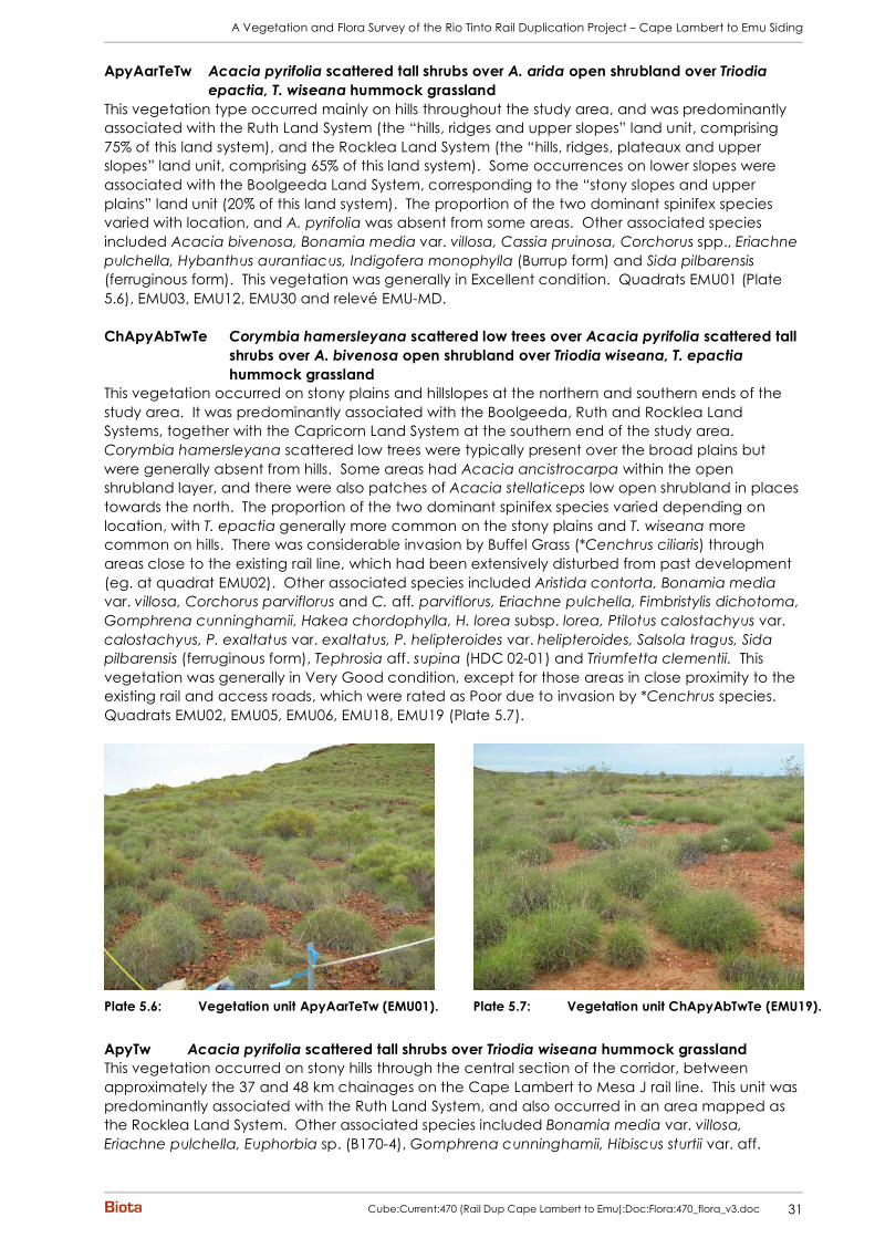
This vegetation type occurred mainly on hills throughout the study area, and was predominantly associated with the Ruth Land System (the “hills, ridges and upper slopes” land unit, comprising 75% of this land system), and the Rocklea Land System (the “hills, ridges, plateaux and upper slopes” land unit, comprising 65% of this land system). Some occurrences on lower slopes were associated with the Boolgeeda Land System, corresponding to the “stony slopes and upper plains” land unit (20% of this land system). The proportion of the two dominant spinifex species varied with location, and A. pyrifolia was absent from some areas. Other associated species included Acacia bivenosa, Bonamia media var. villosa, Cassia pruinosa, Corchorus spp., Eriachne pulchella, Hybanthus aurantiacus, Indigofera monophylla (Burrup form) and Sida pilbarensis (ferruginous form). This vegetation was generally in Excellent condition. Quadrats EMU01 (Plate 5.6), EMU03, EMU12, EMU30 and relevé EMU-MD. ChApyAbTwTe Corymbia hamersleyana scattered low trees over Acacia pyrifolia scattered tall
shrubs over A. bivenosa open shrubland over Triodia wiseana, T. epactia hummock grassland
This vegetation occurred on stony plains and hillslopes at the northern and southern ends of the study area. It was predominantly associated with the Boolgeeda, Ruth and Rocklea Land Systems, together with the Capricorn Land System at the southern end of the study area. Corymbia hamersleyana scattered low trees were typically present over the broad plains but were generally absent from hills. Some areas had Acacia ancistrocarpa within the open shrubland layer, and there were also patches of Acacia stellaticeps low open shrubland in places towards the north. The proportion of the two dominant spinifex species varied depending on location, with T. epactia generally more common on the stony plains and T. wiseana more common on hills. There was considerable invasion by Buffel Grass (*Cenchrus ciliaris) through areas close to the existing rail line, which had been extensively disturbed from past development (eg. at quadrat EMU02). Other associated species included Aristida contorta, Bonamia media var. villosa, Corchorus parviflorus and C. aff. parviflorus, Eriachne pulchella, Fimbristylis dichotoma, Gomphrena cunninghamii, Hakea chordophylla, H. lorea subsp. lorea, Ptilotus calostachyus var. calostachyus, P. exaltatus var. exaltatus, P. helipteroides var. helipteroides, Salsola tragus, Sida pilbarensis (ferruginous form), Tephrosia aff. supina (HDC 02-01) and Triumfetta clementii. This vegetation was generally in Very Good condition, except for those areas in close proximity to the existing rail and access roads, which were rated as Poor due to invasion by *Cenchrus species. Quadrats EMU02, EMU05, EMU06, EMU18, EMU19 (Plate 5.7).
Plate 5.6: Vegetation unit ApyAarTeTw (EMU01). Plate 5.7: Vegetation unit ChApyAbTwTe (EMU19).
ApyTw Acacia pyrifolia scattered tall shrubs over Triodia wiseana hummock grassland This vegetation occurred on stony hills through the central section of the corridor, between approximately the 37 and 48 km chainages on the Cape Lambert to Mesa J rail line. This unit was predominantly associated with the Ruth Land System, and also occurred in an area mapped as the Rocklea Land System. Other associated species included Bonamia media var. villosa, Eriachne pulchella, Euphorbia sp. (B170-4), Gomphrena cunninghamii, Hibiscus sturtii var. aff.

A Vegetation and Flora Survey of the Rio Tinto Rail Duplication Project – Cape Lambert to Emu Siding
32 Cube:Current:470 (Rail Dup Cape Lambert to Emu):Doc:Flora:470_flora_v3.doc
grandiflorus, Indigofera monophylla (Burrup form), Leptopus decaisnei, Polycarpaea longiflora, Solanum diversiflorum, Tephrosia aff. supina (HDC 02-01), Trachymene oleracea subsp. oleracea, Tribulus suberosus, Trichodesma zeylanicum var. zeylanicum and Triumfetta clementii. This vegetation was in Very Good to Excellent condition. Quadrats EMU22, EMU24, EMU29 (Plate 5.8). ApyTe Acacia pyrifolia scattered tall shrubs over Triodia epactia hummock grassland This vegetation occurred in relatively small stands on stony plains through the corridor associated with the Ruth Land System, and would correspond to part of the “lower slopes and stony plains” land unit (15% of this land system). Other associated species included Bonamia media var. villosa, Euphorbia coghlanii, Evolvulus alsinoides var. villosicalyx, Hakea chordophylla, H. lorea subsp. lorea, Tephrosia aff. supina (HDC 02-01), Triodia wiseana (scattered hummocks only) and Triumfetta clementii. This vegetation was generally in Very Good condition, with scattered individuals of *Cenchrus species typically present. Quadrats EMU04, EMU27 (Plate 5.9).
Plate 5.8: Vegetation unit ApyTw (EMU29). Plate 5.9: Vegetation unit ApyTe (EMU27).
ChAiTw Corymbia hamersleyana scattered low trees over Acacia inaequilatera tall open
shrubland over Triodia wiseana open hummock grassland This vegetation occurred on rocky hillslopes, crests and footslopes in the southern third of the rail corridor, between approximately the 60 to 65 km chainages on the Cape Lambert to Mesa J rail line. This unit was strongly correlated with the Rocklea Land System, and would correspond to the “hills, ridges, plateaux and upper slopes” and “lower slopes” land units, which together comprise 80% of this land system. The low trees of Corymbia hamersleyana were mainly present on the footslopes (Plate 5.10), and disappeared further up the hills (Plate 5.11). Other associated species included Bonamia media var. villosa, Bulbostylis barbata, Cleome viscosa, Gomphrena cunninghamii, Polygala aff. isingii, Sida pilbarensis (ferruginous form) and Triumfetta clementii. This vegetation was typically in Very Good to Excellent condition. Quadrat EMU42 and relevé EMU-MJ.
Plate 5.10: Vegetation unit ChAiTw on footslopes
(EMU42). Plate 5.11: Vegetation unit ChAiTw on hill (EMU-MJ).

A Vegetation and Flora Survey of the Rio Tinto Rail Duplication Project – Cape Lambert to Emu Siding
Cube:Current:470 (Rail Dup Cape Lambert to Emu):Doc:Flora:470_flora_v3.doc 33
ChAbTw Corymbia hamersleyana scattered low trees over Acacia bivenosa tall open shrubland over Triodia wiseana hummock grassland
This vegetation occurred over broad stony plains scattered through the corridor, in areas mapped variously as the Boolgeeda, Calcrete and Ruth Land Systems. Other associated species included Acacia inaequilatera, A. pyrifolia, Bonamia media var. villosa, Cassia glutinosa, Hakea chordophylla, Indigofera monophylla (grey leaflet form), Ptilotus astrolasius var. astrolasius and Trichodesma zeylanicum var. zeylanicum. This vegetation was typically in Very Good to Excellent condition. Quadrats EMU38, EMU47. ApyAsyTe Acacia pyrifolia, A. synchronicia open shrubland over Triodia epactia hummock
grassland This vegetation occurred on more loamy areas within the broad clayey plains from north of the North West Coastal Highway to approximately the 29 km chainage. It would correspond most strongly with the Horseflat Land System, and probably represents part of the “non-gilgaied, sometimes stony plains” land unit, which makes up 30% of this land system (van Vreeswyk et al. 2004). Other associated species included Acacia bivenosa, Aristida contorta, Bonamia media var. villosa, Cassia notabilis, Eragrostis eriopoda, E. xerophila, Ptilotus exaltatus var. exaltatus, Sida echinocarpa and Yakirra australiensis var. australiensis. This vegetation was in Very Good condition, with only scattered weeds (mainly *Cenchrus ciliaris). Quadrat EMU08 (Plate 5.12). 5.2.3.2 Hummock grasslands dominated by Triodia angusta
Ta Triodia angusta hummock grassland This vegetation occurred on broad stony plains with a calcareous clay-loam substrate between the 62 km and 65 km chainages on the Cape Lambert to Mesa J rail line. This unit was associated with the Boolgeeda Land System, and would represent part of the “stony lower plains” land unit, which comprises 65% of this land system (van Vreeswyk et al. 2004). Other associated species included Atriplex codonocarpa, Bulbostylis turbinata, Cuscuta victoriana, Dactyloctenium radulans, Dichanthium sericeum subsp. humilius, Enchylaena tomentosa var. tomentosa, Eragrostis xerophila, Euphorbia boophthona, Indigofera trita, Ipomoea muelleri, Iseilema vaginiflorum, Neptunia dimorphantha, Phyllanthus maderaspatensis, Portulaca conspicua, Ptilotus gomphrenoides var. gomphrenoides, Rhynchosia minima, Salsola tragus, Sesbania cannabina, Solanum diversiflorum, Sporobolus australasicus, Streptoglossa bubakii, Trianthema triquetra and Xerochloa laniflora. This unit was considered to be in Very Good condition overall, with only scattered introduced grasses recorded. Quadrat EMU39 (Plate 5.13).
Plate 5.12: Vegetation unit ApyAsyTe (EMU08). Plate 5.13: Vegetation unit Ta (EMU39).

A Vegetation and Flora Survey of the Rio Tinto Rail Duplication Project – Cape Lambert to Emu Siding
34 Cube:Current:470 (Rail Dup Cape Lambert to Emu):Doc:Flora:470_flora_v3.doc
5.2.4 Vegetation of Rockpiles
Two main vegetation types were identified on rockpiles in the study area: TERcTw Terminalia canescens low open woodland over Triodia wiseana open hummock grassland This vegetation type occurred on the rocky chert hills south of the North West Coastal Highway, as well as on basalt rockpiles with a reasonable level of soil development throughout the corridor. It was most strongly associated with the Rocklea and Ruth Land Systems. Within the former land system, the “hills, ridges, plateaux and upper slopes” land unit is described as including “much outcrop of basalt”; “outcrop of parent rock” is similarly listed under the “hills, ridges and upper slopes” land unit for the Ruth Land System (van Vreeswyk et al. 2004). Other species associated with this vegetation type included Abutilon aff. lepidum (4), Acacia coriacea, A. pyrifolia, Aristida burbidgeae, Bonamia media var. villosa, Brachychiton acuminatus, Cajanus cinereus, Capparis spinosa var. nummularia, Cassia glutinosa, C. oligophylla, Cheilanthes sieberi subsp. sieberi, Cleome viscosa, Clerodendrum floribundum var. angustifolium, Cucumis maderaspatanus, Cymbopogon ambiguus, Cyperus cunninghamii subsp. cunninghamii, Dichrostachys spicata, Dicliptera armata, Ehretia saligna var. saligna, Eriachne mucronata, Euphorbia biconvexa, Ficus brachypoda, Flueggea virosa subsp. melanthesoides, Gomphrena cunninghamii, Hibiscus sturtii var. aff. grandiflorus, Hybanthus aurantiacus, Indigofera monophylla (Burrup form), I. trita, Jasminum didymum subsp. lineare, Leptopus decaisnei, Paspalidium tabulatum, Phyllanthus maderaspatanus, Polycarpaea longiflora, Ptilotus obovatus, Rhynchosia minima, Tephrosia aff. supina (HDC 02-01), Tinospora smilacina, Tribulus suberosus, Trichodesma zeylanicum var. zeylanicum, Trichosanthes cucumerina var. cucumerina, Triumfetta clementii and T. maconochieana. This vegetation was typically in Good to Very Good condition, usually showing some level of weed invasion by Buffel Grass (*Cenchrus ciliaris). Relevés EMU-MA (Plate 5.14), EMU-ME, EMU-MG. AcDIsEHsTwCEc Acacia coriacea subsp. coriacea, Dichrostachys spicata, Ehretia saligna tall
open shrubland over Triodia wiseana very open hummock grassland and/or *Cenchrus ciliaris very open tussock grassland
This vegetation occurred on basalt rockpiles throughout the rail corridor, again associated with the Rocklea and Ruth Land Systems as for unit TERcTw. Vegetation over the whole rockpile was typically sparse, concentrated in patches where soil had accumulated. *Cenchrus ciliaris had often invaded these patches, reducing condition from Very Good to Good. This unit was floristically quite similar to unit TERcTw; other associated species included Acacia bivenosa, A. pyrifolia, Aristida burbidgeae, Capparis spinosa var. nummularia, Cleome viscosa, Clerodendrum floribundum var. angustifolium, Cucumis maderaspatanus, Cyperus cunninghamii subsp. cunninghamii, Flueggea virosa subsp. melanthesoides, Gomphrena cunninghamii, Gossypium australe (Whim Creek form), Hybanthus aurantiacus, Jasminum didymum subsp. lineare, Rhagodia eremaea, Rhynchosia minima, Scaevola spinescens, Tinospora smilacina, Trichosanthes cucumerina var. cucumerina, Triodia epactia, Triumfetta clementii and T. maconochieana. This vegetation was typically in Good to Very Good condition, with some invasion by *Cenchrus ciliaris. Relevés EMU-MC (Plate 5.15), EMU-MK.
Plate 5.14: Vegetation unit TERcTw (EMU-MA). Plate 5.15: Vegetation unit AcDIsEHsTwCEc (EMU-MC).

A Vegetation and Flora Survey of the Rio Tinto Rail Duplication Project – Cape Lambert to Emu Siding
Cube:Current:470 (Rail Dup Cape Lambert to Emu):Doc:Flora:470_flora_v3.doc 35
5.2.5 Vegetation of Clayey Plains
A number of vegetation types were identified on the areas of heavy clay within the rail corridor. 5.2.5.1 Grasslands / Herblands
ERAx Eragrostis xerophila open tussock grassland This vegetation (Plate 5.16) dominated the broad clayey plains of the Horseflat Land System from just north of the North West Coastal Highway to approximately the 27.5 km chainage on the Cape Lambert to Mesa J rail line, and between approximately the 33 and 36.5 km chainages. There was also a small stand approximately 500 m west of the 12 km chainage. This unit would probably include parts of the “gilgaied plains”, “non-gilgaied, sometimes stony plains” and “alluvial plains” land units, which comprise 52%, 30% and 10% respectively of the Horseflat Land System (van Vreeswyk et al. 2004). Very scattered tall shrubs of Acacia inaequilatera, A. xiphophylla, Dichrostachys spicata and/or *Vachellia farnesiana were frequently present, particularly along flowlines through the plains. Wetter areas contained Eriachne flaccida / E. benthamii open to closed tussock grasslands (Plate 5.17). Other associated species included Boerhavia paludosa, Cleome viscosa, Corchorus tridens, Dactyloctenium radulans, Desmodium muelleri, Euphorbia coghlanii, Gomphrena affinis subsp. pilbarensis, Heliotropium conocarpum, Indigofera linifolia, I. trita, Ipomoea coptica, Iseilema vaginiflorum, Operculina aequisepala, Panicum laevinode, Phyllanthus maderaspatensis, Ptilotus exaltatus var. exaltatus, P. murrayi, Rhynchosia minima, Salsola tragus, Sida aff. fibulifera “var. L”, Stemodia kingii, Tephrosia aff. clementii (9) (HD284-6) and Xerochloa laniflora. This vegetation was generally in Good to Very Good condition, with *Cenchrus ciliaris and *Vachellia farnesiana prominent in some areas. Quadrats EMU10, EMU11 (Plate 5.16), EMU13, EMU17, EMU21 of this study; quadrat MWS02 of Biota (2008c).
Plate 5.16: Vegetation unit ERAx (EMU11). Plate 5.17: Patch of Eriachne flaccida open tussock
grassland within vegetation unit ERAx.
H/G Herbland/annual grassland This vegetation type occurred on heavy clay soils around the 59 km chainage on the Cape Lambert to Mesa J rail line. This unit appears to correspond to the “gilgai plains” land unit, which comprises 2% of the Pyramid Land System (van Vreeswyk et al. 2004). It was dominated by annual grasses such as Dichanthium sericeus subsp. humilius, and annual to perennial herbs such as Neptunia dimorphantha, Desmodium muelleri, Euphorbia coghlanii and Heliotropium conocarpum. Other associated species included Aristida latifolia, Boerhavia coccinea, Brachyachne convergens, Cleome viscosa, Corchorus tridens, Heliotropium crispatum, Ipomoea lonchophylla, Oldenlandia crouchiana, Operculina aequisepala, Paspalidium constrictum, Ptilotus exaltatus var. exaltatus, P. gomphrenoides var. gomphrenoides, Rhynchosia minima, Salsola tragus, Sida aff. fibulifera “var. L”, Sporobolus australasicus, Stemodia grossa and Tribulus occidentalis. This unit was in Very Good to Excellent condition, with only very occasional weeds (mainly *Cucumis sp.). Quadrat EMU36 (Plate 5.18).
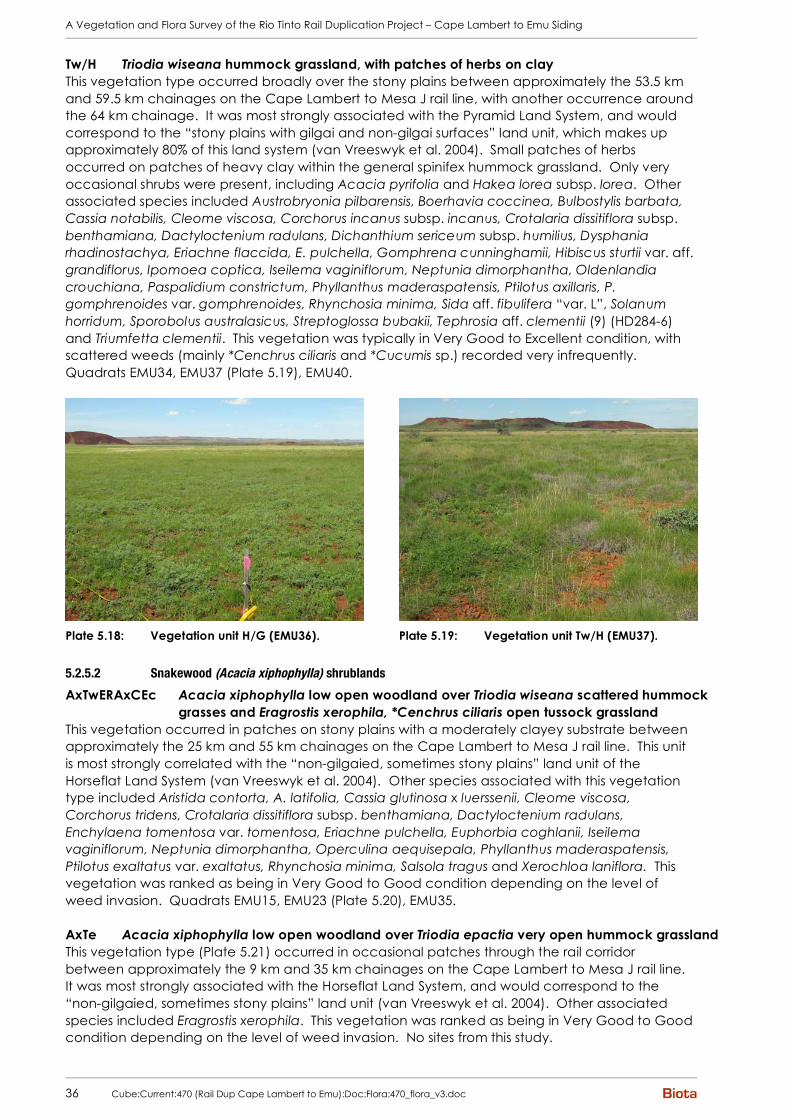
A Vegetation and Flora Survey of the Rio Tinto Rail Duplication Project – Cape Lambert to Emu Siding
36 Cube:Current:470 (Rail Dup Cape Lambert to Emu):Doc:Flora:470_flora_v3.doc
Tw/H Triodia wiseana hummock grassland, with patches of herbs on clay This vegetation type occurred broadly over the stony plains between approximately the 53.5 km and 59.5 km chainages on the Cape Lambert to Mesa J rail line, with another occurrence around the 64 km chainage. It was most strongly associated with the Pyramid Land System, and would correspond to the “stony plains with gilgai and non-gilgai surfaces” land unit, which makes up approximately 80% of this land system (van Vreeswyk et al. 2004). Small patches of herbs occurred on patches of heavy clay within the general spinifex hummock grassland. Only very occasional shrubs were present, including Acacia pyrifolia and Hakea lorea subsp. lorea. Other associated species included Austrobryonia pilbarensis, Boerhavia coccinea, Bulbostylis barbata, Cassia notabilis, Cleome viscosa, Corchorus incanus subsp. incanus, Crotalaria dissitiflora subsp. benthamiana, Dactyloctenium radulans, Dichanthium sericeum subsp. humilius, Dysphania rhadinostachya, Eriachne flaccida, E. pulchella, Gomphrena cunninghamii, Hibiscus sturtii var. aff. grandiflorus, Ipomoea coptica, Iseilema vaginiflorum, Neptunia dimorphantha, Oldenlandia crouchiana, Paspalidium constrictum, Phyllanthus maderaspatensis, Ptilotus axillaris, P. gomphrenoides var. gomphrenoides, Rhynchosia minima, Sida aff. fibulifera “var. L”, Solanum horridum, Sporobolus australasicus, Streptoglossa bubakii, Tephrosia aff. clementii (9) (HD284-6) and Triumfetta clementii. This vegetation was typically in Very Good to Excellent condition, with scattered weeds (mainly *Cenchrus ciliaris and *Cucumis sp.) recorded very infrequently. Quadrats EMU34, EMU37 (Plate 5.19), EMU40.
Plate 5.18: Vegetation unit H/G (EMU36). Plate 5.19: Vegetation unit Tw/H (EMU37).
5.2.5.2 Snakewood (Acacia xiphophylla) shrublands
AxTwERAxCEc Acacia xiphophylla low open woodland over Triodia wiseana scattered hummock grasses and Eragrostis xerophila, *Cenchrus ciliaris open tussock grassland
This vegetation occurred in patches on stony plains with a moderately clayey substrate between approximately the 25 km and 55 km chainages on the Cape Lambert to Mesa J rail line. This unit is most strongly correlated with the “non-gilgaied, sometimes stony plains” land unit of the Horseflat Land System (van Vreeswyk et al. 2004). Other species associated with this vegetation type included Aristida contorta, A. latifolia, Cassia glutinosa x luerssenii, Cleome viscosa, Corchorus tridens, Crotalaria dissitiflora subsp. benthamiana, Dactyloctenium radulans, Enchylaena tomentosa var. tomentosa, Eriachne pulchella, Euphorbia coghlanii, Iseilema vaginiflorum, Neptunia dimorphantha, Operculina aequisepala, Phyllanthus maderaspatensis, Ptilotus exaltatus var. exaltatus, Rhynchosia minima, Salsola tragus and Xerochloa laniflora. This vegetation was ranked as being in Very Good to Good condition depending on the level of weed invasion. Quadrats EMU15, EMU23 (Plate 5.20), EMU35. AxTe Acacia xiphophylla low open woodland over Triodia epactia very open hummock grassland This vegetation type (Plate 5.21) occurred in occasional patches through the rail corridor between approximately the 9 km and 35 km chainages on the Cape Lambert to Mesa J rail line. It was most strongly associated with the Horseflat Land System, and would correspond to the “non-gilgaied, sometimes stony plains” land unit (van Vreeswyk et al. 2004). Other associated species included Eragrostis xerophila. This vegetation was ranked as being in Very Good to Good condition depending on the level of weed invasion. No sites from this study.

A Vegetation and Flora Survey of the Rio Tinto Rail Duplication Project – Cape Lambert to Emu Siding
Cube:Current:470 (Rail Dup Cape Lambert to Emu):Doc:Flora:470_flora_v3.doc 37
Plate 5.20: Vegetation unit AxTwERAxCEc (EMU23). Plate 5.21: Vegetation unit AxTe.
5.2.6 Vegetation of Drainage Areas
5.2.6.1 Vegetation of the Harding Dam Floodout
A number of vegetation types occurred on the broad floodout area of the Harding Dam, all of which appear to be “artificial” vegetation units: these have formed in response to damming of the Harding River just upstream, in an area which probably previously supported Snakewood (Acacia xiphophylla) shrublands and other clayey vegetation types of the Horseflat Land System, along with spinifex hummock grasslands of the Ruth Land System. Although these units do not represent the natural vegetation originally existing on site, they are dominated by native species which are likely to persist in this modified habitat. EcEvHAi Eucalyptus camaldulensis, E. victrix low woodland to scattered trees over
Halosarcia indica subsp. leiostachya low open heath This vegetation occurred on slightly elevated loamy areas within the broad floodplain created around the Harding Dam area. Other associated species included Abutilon aff. lepidum (4), Cassia notabilis, Corchorus tridens, Eragrostis falcata, Neptunia dimorphantha, Pluchea rubelliflora, Ptilotus exaltatus var. exaltatus, Sesbania cannabina, Sida aff. fibulifera (MET Site 1308), Stemodia grossa, Streptoglossa bubakii and Xerochloa laniflora. This modified vegetation unit was in Very Good condition, with only very occasional weeds. Quadrat EMU32 and relevé EMU-MH (Plate 5.22). EcEvERAf Eucalyptus camaldulensis, E. victrix scattered low trees over Eragrostis falcata
tussock grassland This vegetation occurred on slightly elevated loamy areas within the broad floodplain created around the Harding Dam area. There were varying amounts of Couch Grass (*Cynodon dactylon), depending on the location. Other associated species included Abutilon aff. lepidum (4), Alysicarpus muelleri, Cassia notabilis, Corchorus tridens, Heliotropium pachyphyllum, Ptilotus exaltatus var. exaltatus, Rhynchosia minima, Salsola tragus, Sesbania cannabina, Sporobolus mitchellii and Streptoglossa bubakii. Areas without substantial weed invasion were in very good to Excellent condition, while areas infested by Couch were considered to be in Poor condition. Quadrats EMU28 (Plate 5.23), EMU33.

A Vegetation and Flora Survey of the Rio Tinto Rail Duplication Project – Cape Lambert to Emu Siding
38 Cube:Current:470 (Rail Dup Cape Lambert to Emu):Doc:Flora:470_flora_v3.doc
Plate 5.22: Vegetation unit EcEvHAi (EMU-MH). Plate 5.23: Vegetation unit EcEvERAf (EMU28).
Floodout mosaic The vegetation types EcEvHAi and EcEvERAf, which are more readily distinguishable on aerial photography, occurred together with a mosaic of intermingled units in the Harding Dam floodout area:
• Halosarcia indica subsp. leiostachya, Trianthema triquetra low open shrubland, which was the dominant vegetation type comprising ~85% of the area of this unit (EMU31, Plate 5.24);
• patches of Stemodia grossa low open heath in low-lying areas, comprising ~10% of this unit (Plate 5.25); and
• patches of Leptochloa fusca subsp. fusca closed tussock grassland and stands of dense Sesbania cannabina fringing drainage channels, comprising ~5% of this unit.
Plate 5.24: Low open shrubland dominated by
Halosarcia indica subsp. leiostachya and Trianthema triquetra (EMU31).
Plate 5.25: Low open heath dominated by Stemodia grossa.
5.2.6.2 Vegetation of Major Creeklines and Floodplains dominated by Eucalyptus camaldulensis
EcAamCv Eucalyptus camaldulensis low open forest over Acacia ampliceps tall shrubland over Cyperus vaginatus open sedgeland
This vegetation occurred along the banks of the Harding River, typically fringing permanent pools, along the eastern edge of the rail corridor between approximately the 38.5 km and 45 km chainages on the Cape Lambert to Mesa J rail line. It was associated with the River Land System, and would correspond to the “minor and major channels” land unit, which comprises 20% of this land system (van Vreeswyk et al. 2004). While Cyperus vaginatus was the dominant sedge species on the banks, patches of the rushes Schoenoplectus subulatus and Typha domingensis occurred in the river itself (Plate 5.26). Melaleuca glomerata and M. linophylla were prominent in the tall shrub stratum in places. Other associated species included Amaranthus undulatus, Cleome viscosa, Crotalaria medicaginea, Cucumis maderaspatanus, Dactyloctenium radulans, Indigofera linifolia, Ipomoea muelleri, Phyllanthus maderaspatensis, Pluchea rubelliflora, Sesbania
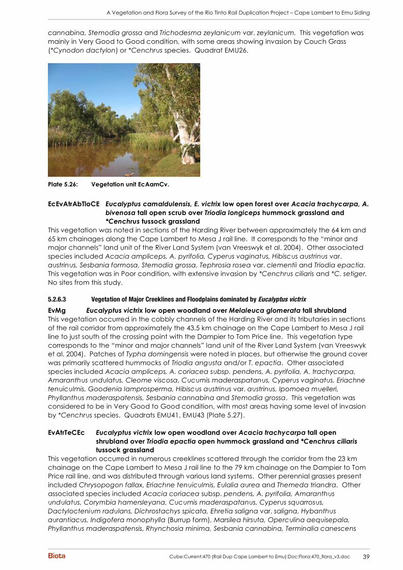
A Vegetation and Flora Survey of the Rio Tinto Rail Duplication Project – Cape Lambert to Emu Siding
Cube:Current:470 (Rail Dup Cape Lambert to Emu):Doc:Flora:470_flora_v3.doc 39
cannabina, Stemodia grossa and Trichodesma zeylanicum var. zeylanicum. This vegetation was mainly in Very Good to Good condition, with some areas showing invasion by Couch Grass (*Cynodon dactylon) or *Cenchrus species. Quadrat EMU26.
Plate 5.26: Vegetation unit EcAamCv.
EcEvAtrAbTloCE Eucalyptus camaldulensis, E. victrix low open forest over Acacia trachycarpa, A.
bivenosa tall open scrub over Triodia longiceps hummock grassland and *Cenchrus tussock grassland
This vegetation was noted in sections of the Harding River between approximately the 64 km and 65 km chainages along the Cape Lambert to Mesa J rail line. It corresponds to the “minor and major channels” land unit of the River Land System (van Vreeswyk et al. 2004). Other associated species included Acacia ampliceps, A. pyrifolia, Cyperus vaginatus, Hibiscus austrinus var. austrinus, Sesbania formosa, Stemodia grossa, Tephrosia rosea var. clementii and Triodia epactia. This vegetation was in Poor condition, with extensive invasion by *Cenchrus ciliaris and *C. setiger. No sites from this study. 5.2.6.3 Vegetation of Major Creeklines and Floodplains dominated by Eucalyptus victrix
EvMg Eucalyptus victrix low open woodland over Melaleuca glomerata tall shrubland This vegetation occurred in the cobbly channels of the Harding River and its tributaries in sections of the rail corridor from approximately the 43.5 km chainage on the Cape Lambert to Mesa J rail line to just south of the crossing point with the Dampier to Tom Price line. This vegetation type corresponds to the “minor and major channels” land unit of the River Land System (van Vreeswyk et al. 2004). Patches of Typha domingensis were noted in places, but otherwise the ground cover was primarily scattered hummocks of Triodia angusta and/or T. epactia. Other associated species included Acacia ampliceps, A. coriacea subsp. pendens, A. pyrifolia, A. trachycarpa, Amaranthus undulatus, Cleome viscosa, Cucumis maderaspatanus, Cyperus vaginatus, Eriachne tenuiculmis, Goodenia lamprosperma, Hibiscus austrinus var. austrinus, Ipomoea muelleri, Phyllanthus maderaspatensis, Sesbania cannabina and Stemodia grossa. This vegetation was considered to be in Very Good to Good condition, with most areas having some level of invasion by *Cenchrus species. Quadrats EMU41, EMU43 (Plate 5.27). EvAtrTeCEc Eucalyptus victrix low open woodland over Acacia trachycarpa tall open
shrubland over Triodia epactia open hummock grassland and *Cenchrus ciliaris tussock grassland
This vegetation occurred in numerous creeklines scattered through the corridor from the 23 km chainage on the Cape Lambert to Mesa J rail line to the 79 km chainage on the Dampier to Tom Price rail line, and was distributed through various land systems. Other perennial grasses present included Chrysopogon fallax, Eriachne tenuiculmis, Eulalia aurea and Themeda triandra. Other associated species included Acacia coriacea subsp. pendens, A. pyrifolia, Amaranthus undulatus, Corymbia hamersleyana, Cucumis maderaspatanus, Cyperus squarrosus, Dactyloctenium radulans, Dichrostachys spicata, Ehretia saligna var. saligna, Hybanthus aurantiacus, Indigofera monophylla (Burrup form), Marsilea hirsuta, Operculina aequisepala, Phyllanthus maderaspatensis, Rhynchosia minima, Sesbania cannabina, Terminalia canescens

A Vegetation and Flora Survey of the Rio Tinto Rail Duplication Project – Cape Lambert to Emu Siding
40 Cube:Current:470 (Rail Dup Cape Lambert to Emu):Doc:Flora:470_flora_v3.doc
and Triumfetta clementii. This vegetation was in Good to Poor condition, depending on the level of weed invasion. Quadrats EMU16, EMU20 (Plate 5.28), and relevés EMU-JAA (with Triodia wiseana), EMU-MB, EMU-MI (this site scoured out from recent floods and lacking A. trachycarpa).
Plate 5.27: Vegetation unit EvMg (EMU43). Plate 5.28: Vegetation unit EvAtrTeCEc (EMU20).
EvTERcApyTwTeCE Eucalyptus victrix, Terminalia canescens low woodland over Acacia
pyrifolia tall open scrub over Triodia wiseana, T. epactia hummock grassland and *Cenchrus ciliaris, *C. setiger open tussock grassland
This vegetation occurred along moderate-sized creeklines through the southern section of the corridor from approximately the 40.5 km chainage, and was distributed across various land systems. Acacia arida was also prominent in the shrub layer in places. Other associated species included Acacia coriacea subsp. pendens, A. tumida var. pilbarensis, A. trachycarpa, Eulalia aurea, Phyllanthus maderaspatensis, Rhynchosia minima and Themeda triandra. This vegetation was in Good to Poor condition depending on the level of weed invasion. No sites from this study. EvApyTwTeCE Eucalyptus victrix scattered low trees over Acacia pyrifolia tall open scrub to tall
open shrubland over Triodia wiseana, T. epactia hummock grassland and *Cenchrus ciliaris, *C. setiger open tussock grassland
This vegetation occurred broadly over the floodplains surrounding the Harding River (mapped as part of the River Land System), as well as in occasional tributaries leading from it (which were scattered across various land systems). It occurred from approximately the 28.5 km chainage on the Cape Lambert to Mesa J rail line to south of the crossing with the Dampier to Tom Price rail line. Other associated species included Acacia arida, A. trachycarpa, Boerhavia gardneri, Chrysopogon fallax, Corchorus tectus, Hakea lorea subsp. lorea, Hybanthus aurantiacus, Indigofera linnaei, I. monophylla (Burrup form), Phyllanthus maderaspatensis, Ptilotus exaltatus var. exaltatus, Rhynchosia minima, Salsola tragus, Themeda triandra, Triumfetta clementii and *Vachellia farnesiana. This vegetation was in Good to Poor condition depending on the level of weed invasion. Quadrat EMU25 (Plate 5.29).
Plate 5.29: Vegetation unit EvApyTwTeCEc (EMU25).

A Vegetation and Flora Survey of the Rio Tinto Rail Duplication Project – Cape Lambert to Emu Siding
Cube:Current:470 (Rail Dup Cape Lambert to Emu):Doc:Flora:470_flora_v3.doc 41
5.2.6.4 Vegetation of Moderate-sized and Minor Flowlines
Not all occurrences of the following vegetation types were mapped due to the small size of many of the flowlines. As many of these units are distributed across various land systems, these have not been mentioned specifically unless there is a relatively distinct correlation. TERcAtrTwCE Terminalia canescens low open woodland over Acacia trachycarpa tall open
shrubland over Triodia wiseana open hummock grassland and *Cenchrus ciliaris, *C. setiger tussock grassland
This vegetation occurred in moderate-sized flowlines at the southern end of the rail corridor, and would correspond to the “upper drainage lines” land unit, which comprises 4% of the Rocklea Land System (van Vreeswyk et al. 2004). Other associated species included Acacia coriacea subsp. pendens, A. pyrifolia, Alternanthera nana, A. nodiflora, Cymbopogon ambiguus, Eriachne tenuiculmis, Flueggea virosa subsp. melanthesoides, Hybanthus aurantiacus, Phyllanthus maderaspatensis and Sesbania cannabina. This vegetation was in Poor condition due to invasion by *Cenchrus species. No sites from this study. TERcAarTw Terminalia canescens low open forest over Acacia arida open shrubland over
Triodia wiseana hummock grassland This vegetation was noted in a single cobbly creekline approximately 500 m north-west of the 42 km chainage on the Cape Lambert to Mesa J rail line. This creek drains out of extensive rockpiles to the north-west. Other associated species included Acacia ancistrocarpa, A. coriacea subsp. pendens, A. pyrifolia, A. trachycarpa, Cassia oligophylla, Dichrostachys spicata, Ehretia saligna var. saligna, Eriachne tenuiculmis, Flueggea virosa subsp. melanthesoides, Hybanthus aurantiacus, Jasminum didymum subsp. lineare, Phyllanthus maderaspatensis, Ptilotus obovatus, Rhynchosia minima, Sesbania cannabina, Solanum horridum, Tinospora smilacina, Trachymene oleracea subsp. oleracea, Trichodesma zeylanicum var. zeylanicum and Triumfetta clementii. Only small amounts of *Cenchrus ciliaris were found within this vegetation type, and it was considered to be in Very Good condition. Relevé EMU-MF (Plate 5.30). ChAtrEUaCHf Corymbia hamersleyana low open woodland over Acacia trachycarpa scattered
tall shrubs over Eulalia aurea, Chrysopogon fallax closed tussock grassland This vegetation occurred in a minor creekline at the 25.3 km chainage on the Cape Lambert to Mesa J rail line. This unit would broadly correspond to the “channels and minor river terraces” land unit, which comprises <1% of the Horseflat Land System (van Vreeswyk et al. 2004). Other associated species included Acacia bivenosa, A. pyrifolia, A. trachycarpa, Alternanthera nana, A. nodiflora, Corchorus incanus subsp. incanus, C. tridens, Crotalaria medicaginea, Cucumis maderaspatanus, Dactyloctenium radulans, Dichrostachys spicata, Eremophila longifolia, Eriachne flaccida, Erythrina vespertilio, Gomphrena affinis subsp. pilbarensis, Hybanthus aurantiacus, Indigofera monophylla (Burrup form), Iseilema vaginiflorum, Marsilea hirsuta, Operculina aequisepala, Panicum decompositum, Phyllanthus maderaspatensis, Rhynchosia minima, Sesbania cannabina, Themeda triandra, Trichodesma zeylanicum var. zeylanicum and Vigna lanceolata var. lanceolata. This vegetation was in Good condition, with some *Cenchrus ciliaris and *Vachellia farnesiana present. Quadrat EMU14 (Plate 5.31).
Plate 5.30: Vegetation unit TERcAarTw (EMU-MF). Plate 5.31: Vegetation unit ChAtrEUaCHf (EMU14).

A Vegetation and Flora Survey of the Rio Tinto Rail Duplication Project – Cape Lambert to Emu Siding
42 Cube:Current:470 (Rail Dup Cape Lambert to Emu):Doc:Flora:470_flora_v3.doc
ChAtrAmTw Corymbia hamersleyana low open woodland over Acacia trachycarpa, A. maitlandii tall open shrubland over Triodia wiseana hummock grassland
This vegetation occurred through minor flowlines at the southern end of the study area, and was associated with the Rocklea Land System. No sites from this study. ChAtuTeCE Corymbia hamersleyana low open woodland over Acacia tumida var.
pilbarensis tall open scrub over Triodia epactia open hummock grassland and *Cenchrus ciliaris, *C. setiger tussock grassland
This vegetation occurred in moderate-sized flowlines, particularly between the 15 and 18.5 km chainages on the Cape Lambert to Mesa J rail line (it was also recorded elsewhere, in flowlines which were too small to map). It was most strongly associated with the Boolgeeda Land System, and would correspond to the “narrow drainage floors and channels” land unit, which comprises 10% of this land system (van Vreeswyk et al. 2004). Other shrubs present at lesser densities included Acacia ancistrocarpa, A. bivenosa and A. pyrifolia. Other associated species included Bonamia media var. villosa, B. rosea, Corchorus parviflorus, Crotalaria medicaginea, Dactyloctenium radulans, Desmodium muelleri, Eulalia aurea, Euphorbia coghlanii, Gossypium australe (Burrup Peninsula form), Hakea lorea subsp. lorea, Hybanthus aurantiacus, Indigofera monophylla (Burrup form), Jasminum didymum subsp. lineare, Rhynchosia minima, Solanum diversiflorum, Themeda triandra, Trichodesma zeylanicum var. zeylanicum and Triumfetta clementii. This vegetation was in Good to Poor condition depending on the level of weed invasion by *Cenchrus grasses. Quadrats EMU07, EMU09 (Plate 5.32). ChAtuTe Corymbia hamersleyana low open woodland over Acacia tumida var. pilbarensis tall
open scrub over Triodia epactia open hummock grassland This vegetation comprised the above unit without significant weed invasion, and was typically in Excellent to Very Good condition (Plate 5.33). The mapped occurrences are between approximately the 10.5 and 15.5 km chainages on the Cape Lambert to Mesa J rail line, however as for unit ChAtuTeCE, it was also recorded elsewhere in flowlines which were too small to map. It was similarly associated with the Boolgeeda Land System.
Plate 5.32: Vegetation unit ChAtuTeCE (EMU09). Plate 5.33: Vegetation unit ChAtuTe.
ChApyAaAbEUaTHt Corymbia hamersleyana low open woodland over Acacia pyrifolia tall
shrubland over A. ancistrocarpa, A. bivenosa open shrubland over Eulalia aurea, Themeda triandra closed tussock grassland
This vegetation was recorded from one creekline at the 19.2 km chainage on the Cape Lambert to Mesa J rail line (Plate 5.34). It would correspond to the “drainage depressions” land unit, which comprises 4% of the Horseflat Land System (van Vreeswyk et al. 2004). The higher reaches of this habitat (closer to the North West Coastal Highway) comprised Acacia inaequilatera tall open shrubland over Chrysopogon fallax tussock grassland with some invasion by *Cenchrus ciliaris. Other associated species included *Vachellia farnesiana. This vegetation was rated as being in Good condition due to the level of invasion by *Cenchrus grasses. No sites from this study.

A Vegetation and Flora Survey of the Rio Tinto Rail Duplication Project – Cape Lambert to Emu Siding
Cube:Current:470 (Rail Dup Cape Lambert to Emu):Doc:Flora:470_flora_v3.doc 43
Plate 5.34: Vegetation unit ChApyAaAbEUaTHt.
ChAbTeTw Corymbia hamersleyana low open woodland over Acacia bivenosa tall shrubland
over Triodia epactia (T. wiseana) hummock grassland This vegetation occurred in minor flowlines between the 30 and 33 km chainages, mainly associated with the Ruth Land System. Other associated species included Ipomoea muelleri, Stemodia grossa, Streptoglossa decurrens and Triumfetta clementii. This vegetation was in Very Good condition. No sites from this study. AtrAcAbApyCE Acacia trachycarpa, A. coriacea subsp. pendens, A. bivenosa, A. pyrifolia tall
open scrub over *Cenchrus ciliaris, *C. setiger tussock grassland This vegetation occurred in a creekline on the eastern side of the rail between approximately the 26 and 27.5 km chainages on the Cape Lambert to Mesa J rail line, and would be associated with the “drainage depressions” land unit, which comprises 4% of the Horseflat Land System (van Vreeswyk et al. 2004). The dominance of the major shrub species varied depending on location within the creekline, and other associated species included Acacia inaequilatera. This unit was in Poor condition as a result of infestation by *Cenchrus grasses. No sites from this study. ApyAaTw Acacia pyrifolia tall open shrubland over A. ancistrocarpa open heath over Triodia
wiseana open hummock grassland This vegetation occurred in minor flowlines through the Ruth Land System between the 41 and 42 km chainages on the Cape Lambert to Mesa J rail line. Other associated species included Acacia orthocarpa, and *Cenchrus ciliaris and *C. setiger were prominent around the existing rail and on the downstream slope towards the Harding River. This vegetation was in Good to Poor condition depending on the level of invasion by *Cenchrus species. No sites from this study.
5.3 Conservation Significance of the Vegetation Types
5.3.1 Overall Vegetation Condition
Given the location of the Cape Lambert to Emu Siding rail corridor (encompassing existing rail structures and access roads), the study area contained significant areas of disturbance; areas of ground historically cleared for the existing infrastructure, as well as for borrow pits, laydown areas, camp sites, etc. These areas typically supported regenerating shrublands of species from the surrounding areas over an very open cover of spinifex which was frequently invaded by large amounts of *Cenchrus grasses. Large sections of the study area had been recently burnt, particularly at the northern end of the corridor. By itself this would not be considered to reduce the condition of the vegetation, however areas in the vicinity of Wickham appeared to have been subject to repeated fires coupled with historic clearing, which had resulted in considerable invasion of the loamy plains by Buffel Grass (*Cenchrus ciliaris) and Birdwood Grass (*C. setiger).

A Vegetation and Flora Survey of the Rio Tinto Rail Duplication Project – Cape Lambert to Emu Siding
44 Cube:Current:470 (Rail Dup Cape Lambert to Emu):Doc:Flora:470_flora_v3.doc
With respect to weed invasion, there were often substantial infestations of *Cenchrus species in close proximity to the existing rail, however apart from at the northern end of the corridor, these did not typically penetrate far into the surrounding undisturbed habitats stony plains and hills. These species were, however, prevalent along many of the creeklines dissecting the study area, as well as on the broad loamy floodplains of the Harding River. Overall, the condition of vegetation in the Cape Lambert to Emu Siding rail corridor was considered to be Excellent to Very Good for areas of stony hills, stony plains and clayey plains removed from existing infrastructure; Good to Poor for creeklines infested with *Cenchrus species; and Poor to Completely Degraded for areas mapped as “Disturbed”.
5.3.2 Assessment at the Level of the Vegetation Types Defined by this Study
The following vegetation types are considered to be of High conservation significance, and clearing of these units should be avoided: • Cracking clay communities of the Chichester Range and Mungaroona Range (units H/G and
Tw/H) Cracking clay communities of the Chichester Range and Mungaroona Range are listed as a Priority 1 Ecological Community, and are considered to be under threat from grazing (Kendrick and McKenzie 2001; see Section 4.5.2). The area mapped as vegetation units H/G and Tw/H on the broad cracking clay upland between approximately the 53.5 and 59.7 km chainages and the 63.6 and the 64.6 km chainages along the Cape Lambert to Mesa J rail line is considered to comprise this PEC. The vegetation in these areas is generally in Excellent condition.
• Riparian vegetation of the Harding River and its larger tributaries (principally units EcAamCv,
EvMg and EvApyTwTeCE; also EvAtrTeCEc and EvTERcApyTwTeCE) The Harding River comprises the main drainage feature for this locality, and supports dense riparian forest of River Red Gum (Eucalyptus camaldulensis), with patches of Cadjeput (Melaleuca argentea) in places. Although there is considerable invasion by weeds (mainly *Cenchrus grasses) along the floodplains of this river system, it is still considered to have High conservation value. The additional creekline units dominated by E. victrix (see Section 5.2.6.3) are also of significance as they comprise major drainages for these areas. Clearing within these vegetation units should be strictly controlled, and appropriate culverting must be established to maintain existing surface flows through these systems.
The following vegetation types are considered to be of Moderate conservation significance, and clearing should be minimised: • Mangrove vegetation (AVm)
The small stands of mangal dominated by Avicennia marina occur in the north-western corner of the rail corridor are considered to be of Moderate conservation value. Clearing of these areas should be avoided if possible, and otherwise minimised.
• Eragrostis xerophila tussock grasslands on clay (ERAx)
Three areas of coastal grassland on cracking clay near Dampier (approximately 25 km to the west of the northern end of the Cape Lambert to Emu Siding rail duplication corridor) are mapped as the Roebourne Plains coastal grasslands Priority 1 Ecological Community (see Section 4.5.2). These areas comprise particularly good quality examples of this community, which is described as “disappearing cracking clays under threat from grazing”. While broadly equivalent vegetation (Eragrostis xerophila grassland) is widespread over the cracking clay plains in the Dampier to Roebourne locality, it is typically in a somewhat to very degraded condition from historic grazing, physical disturbance and/or weed invasion.
A Vegetation and Flora Survey of the Rio Tinto Rail Duplication Project – Cape Lambert to Emu Siding
Cube:Current:470 (Rail Dup Cape Lambert to Emu):Doc:Flora:470_flora_v3.doc 45
Eragrostis xerophila grassland vegetation on clay substrates (unit ERAx; see Section 5.2.5.1) occurs within the current study area at a number of points along the existing Cape Lambert to Mesa J rail line, including:
• Approximately 500 m west of the 12 km chainage (a very small stand between 7712600 mN and 7712350 mN);
• between the 19.2 and 27.5 km chainages (several large swathes between 7704950 mN and 7696250 mN); and
• between the 33 and 36.5 km chainages (one large swathe between 7691500 mN and 7688050 mN).
While some of these areas of vegetation are in Excellent condition (especially on the southernmost plain), none are particularly similar to the areas designated as the PEC near Dampier, and it is questionable whether any of the stands within the rail corridor would be considered to be of equivalent value. Nonetheless, these areas probably warrant a Moderate conservation value ranking.
• Rockpile vegetation (TERcTw and AcDIsEHsTwCEc)
The numerous rockpiles through the rail corridor support species restricted to such habitats, and clearing of these areas should be avoided if possible and otherwise minimised.
The remaining vegetation types are considered to be of Low conservation significance, representing units that are likely to be more widely distributed and relatively well represented in the Chichester subregion. Note that this is not meant to imply that these units have no conservation value, as the majority comprise good quality examples of intact native vegetation, and are therefore inherently valuable: it simply indicates that they are less of a priority for conservation than those identified as High or Moderate. Clearing of these units should be minimised wherever possible.

A Vegetation and Flora Survey of the Rio Tinto Rail Duplication Project – Cape Lambert to Emu Siding
46 Cube:Current:470 (Rail Dup Cape Lambert to Emu):Doc:Flora:470_flora_v3.doc
This page intentionally blank.

A Vegetation and Flora Survey of the Rio Tinto Rail Duplication Project – Cape Lambert to Emu Siding
Cube:Current:470 (Rail Dup Cape Lambert to Emu):Doc:Flora:470_flora_v3.doc 47
6.0 Flora
6.1 Overview of the Flora of the Study Area
6.1.1 Overall Species Richness
A total of 369 taxa of native vascular flora from 145 genera belonging to 57 families has been recorded from the Cape Lambert to Emu Siding project area (including the results from the 2008 survey, together with the quadrats previously sampled in the area during the Cape Lambert Port B Expansion survey (Biota 2008a) and the Dampier Power Station Transmission Line study (Biota 2008c)). In addition, 17 introduced species were recorded (see Section 6.3). Species richness tends to vary on a logarithmic scale with the size of the study area, and is also affected by the shape of the study area (long linear corridors will tend to intersect a broader range of habitats than more regular rectangular polygons). In comparison with the Cape Lambert to Emu Siding rail corridor, which was some 4,556 ha in size:
• A total of 131 species of native flora from 83 genera belonging to 39 families was recorded from the combined Cape Lambert Substation and Infrastructure Area, which was 40 ha in size and encompassed a small range of near-coastal habitats (Biota 2008b).
• A total of 183 native vascular flora taxa from 94 genera belonging to 41 families was recorded from the Cape Lambert Port B Expansion study area, which was 602 ha in size and included a relatively small range of coastal and near-coastal habitats (Biota 2008a).
• A total of 221 native vascular flora taxa from 105 genera belonging to 40 families was recorded from the Dampier to Cape Lambert Transmission Line Corridor survey area (Biota 2008c). This area was 680 ha in size and extended over some 63 km between the two localities, including a broader geographic range and a greater variety of habitats than those sampled at Cape Lambert.
• A total of 475 native vascular flora species from 177 genera and 60 families was recorded from the Emu Siding to Rosella Siding rail duplication study (Biota 2008d). This study area comprises a series of 39 separate areas, which begin at the southern end of the current study area, extending between the 83 km and 242 km chainages on the Dampier to Tom Price rail line. While this study area is less than half the size of the Cape Lambert to Emu Siding rail corridor (at some 2,145 ha in total size), it covers a broader geographic range than the latter study area and includes large sections of both the Chichester and Hamersley subregions, together with a more diverse array of habitats.
• A total of 437 taxa of native vascular flora from 160 genera belonging to 57 families was recorded from the combined Warramboo Deposit, Yarraloola Borefield and the Mesa A to Mesa J transport corridor (Biota 2006). This study area was 7,045 ha in total, and extended over a geographic distance of some 50 km.
• A total of 331 taxa of native vascular flora from 136 genera belonging to 46 families was recorded from the Bellbird Siding to Juna Downs rail duplication corridor during survey work in 2008 (Biota 2008e). This study area begins 140 km south-south-east of the southern end of the current study area, and extends for some 120 km to the south-east. While it was considerably larger in size than the current study area at 8,982 ha, conditions were less favourable at the time of the field survey and it was therefore sampled less intensively. It also traversed only a single subregion (Hamersley).
Taking into account the disparity in sampling intensity and the different range of habitats encompassed by the various project areas, the number of species recorded from the Cape Lambert to Emu Siding rail corridor appears to be within the range expected for a corridor of this size in this part of the Pilbara. The number of species would be expected to increase with repeated sampling over a range of seasons.

A Vegetation and Flora Survey of the Rio Tinto Rail Duplication Project – Cape Lambert to Emu Siding
48 Cube:Current:470 (Rail Dup Cape Lambert to Emu):Doc:Flora:470_flora_v3.doc
6.1.2 Dominant Plant Groups and Species
The families and genera with the greatest number of species are shown in Table 6.1 and Table 6.2 respectively. These families and genera are those that are predominant in the Pilbara and that usually have many representatives on flora lists from this region, due to their presence in the Eremaean flora. Some of the families (eg. Amaranthaceae, Malvaceae and Poaceae) are more species rich in the Northern flora and poorer in the Southern flora whilst others (such as the Mimosaceae) are abundant in all three provinces. In contrast to these families and genera that have many representatives, 24 families and 77 genera recorded during the survey were only represented by only one taxon (Appendix 5). These included Cynanchum (Asclepiadaceae), Terminalia (Combretaceae), Frankenia (Frankeniaceae), Potamogeton (Potamogetonaceae) and Muellerolimon (Plumbaginaceae). The most frequently recorded species across the study area were Acacia pyrifolia, A. bivenosa, Bonamia media var. villosa, Phyllanthus maderaspatensis, Rhynchosia minima, Triodia epactia, T. wiseana and Triumfetta clementii. Some of these species are commonly dominant in the vegetation of the area (eg. the spinifex (Triodia) species), or frequently contribute to its structure (eg. Acacia pyrifolia); others such as Triumfetta clementii are widespread through a variety of habitats at low density.
Table 6.1: Plant families with the greatest number of native species in the project area.
Family Number of Native Species
Poaceae (grass family) 60
Papilionaceae (peas family) 42
Malvaceae (hibiscus family) 27
Amaranthaceae (mulla-mulla family) 22
Mimosaceae (wattle family) 23
Chenopodiaceae (saltbush, bluebush family) 15
Caesalpiniaceae (cassia family) 14
Convolvulaceae (morning glory family) 14
Tiliaceae (linden family) 14
Asteraceae (daisy family) 12
Cyperaceae (sedge family) 12
Table 6.2: Genera with the greatest number of native species in the project area.
Genus Number of Native Species
Acacia (wattles) 21
Ptilotus (mulla-mullas) 15
Cassia (cassias, sennas) 14
Tephrosia (peas) 13
Corchorus (corchorus) 11
Sida (sidas) 9
Eragrostis (lovegrasses) 8
Eriachne (wanderrie grasses) 8
Abutilon (lantern bushes) 7
Hibiscus (hibiscus) 7
Indigofera (peas) 7

A Vegetation and Flora Survey of the Rio Tinto Rail Duplication Project – Cape Lambert to Emu Siding
Cube:Current:470 (Rail Dup Cape Lambert to Emu):Doc:Flora:470_flora_v3.doc 49
6.2 Flora of Conservation Significance
6.2.1 Probability of Declared Rare Flora Occurring in the Study Area
No DRF listed under the Commonwealth EPBC Act 1999 or listed by the WA DEC were recorded from the Cape Lambert to Emu Siding rail duplication corridor, and none would be expected to occur (see Sections 4.6.1 and 4.6.2).
6.2.2 Priority Flora Occurring in the Study Area
Two Priority species were recorded from the Cape Lambert to Emu Siding rail duplication corridor, the locations of which should be avoided: • Nicotiana heterantha (Priority 1)
This annual herb (Plate 6.1) is described on FloraBase as occurring on heavy clays on seasonally wet flats. A single specimen was collected from vegetation unit EcEvHAi at the southern edge of the Harding Dam floodout area (Table 6.3). Given the annual growth form and slender habit of this species, it may well be more broadly distributed through the rail corridor. This record represents a substantial range extension to the north-west within the Pilbara; this species is also known from the western Kimberley.
Table 6.3: Record of Nicotiana heterantha from the Cape Lambert to Emu Siding rail corridor.
Location Easting (mE) Northing (mN) Density
EMU32 509527 7675320 scattered
Plate 6.1: Flowers and habit of Nicotiana heterantha (photography by
G. Byrne; image used with the permission of the Western Australian Herbarium, Department of Environment and Conservation (http://florabase.calm.wa.gov.au/help/copyright); accessed on Wednesday, 06/08/08).
• Hibiscus brachysiphonius (Priority 3)
This perennial herb / low shrub had a broad distribution from the Carnarvon bioregion through to the Kimberley, with most vouchered specimens collected from the Pilbara. It typically occurs on heavy clay substrates, often with gilgai. This species was recorded as scattered individuals at three widely separated locations in the rail corridor: approximately 200 m west of the 25.5 km chainage, less than 100 m east of the 33.2 km chainage, and 100 m west of the 51.1 km chainage on the Cape Lambert to Mesa J line (Table 6.4). All of the records were from

A Vegetation and Flora Survey of the Rio Tinto Rail Duplication Project – Cape Lambert to Emu Siding
50 Cube:Current:470 (Rail Dup Cape Lambert to Emu):Doc:Flora:470_flora_v3.doc
areas of heavy clay supporting Eragrostis xerophila grasslands, which had a variable overstorey ranging from Snakewood (Acacia xiphophylla) shrubland, virtually no overstorey, and samphire low shrubland for the three locations respectively. Given the inconspicuous nature of this low shrub/perennial herb, and the broad extent of suitable habitat through this corridor, it is likely that this species is more widely distributed within the study area.
Table 6.4: Records of Hibiscus brachysiphonius from the Cape Lambert to Emu Siding rail corridor.
Location Easting (mE) Northing (mN) Density
EMU15 509938 7698715 scattered
EMU21 510844 7691154 scattered
OPP-M17 509536 7676500 x7
6.2.3 Probability of Other Priority Flora Occurring in the Study Area
One of the Priority flora previously known from the broader locality was collected by the current study (Hibiscus brachysiphonius; see Section 6.2.2). Of the other Priority species occurring in the locality (see Section 4.6.3):
• The Priority 3 Acacia glaucocaesia has been recorded from locations both east and west of the northern end of the corridor, and this species could occur within the rail corridor, particularly scattered on the broad near-coastal plains.
• The Priority 3 Terminalia supranitifolia may occur on the basalt rockpiles scattered through the corridor (vegetation units TERcTw and AcDIsEHsTwCEc).
• There is suitable habitat for the remaining species in the heavy clay plains (particularly vegetation units ERAx and H/G), and any of these species could potentially occur through the corridor. If present, Helichrysum oligochaetum would probably only be visible during optimal conditions (after substantial winter rainfall).
6.2.4 Other Flora of Conservation Interest in the Study Area
6.2.4.1 Undescribed Species
• Malvaceae family The Malvaceae family has a high species diversity in the Pilbara bioregion, with a large number of undescribed taxa. The identifications of Abutilon, Hibiscus and Sida specimens in particular are often difficult to resolve, and frequently appear to represent undescribed or new taxa. Similarly, the genera Indigofera and Tephrosia within the Papilionaceae family contain numerous distinct taxa in the Pilbara, particularly within the Indigofera “monophylla”, Tephrosia “clementii,” T. “densa,” T. “rosea,” and T. “supina” complexes. All of the undescribed taxa recorded from the Cape Lambert to Emu Siding rail corridor have been recorded previously from other study areas in the region.
• Euphorbia spp. The genus Euphorbia is similarly diverse within the Pilbara, and contains a large number of undescribed species. The undescribed taxa recorded from the current study area have all been recorded from other survey areas in the region.
• Triodia spp. Within the Pilbara, there is considerable variation within the named spinifex species, particularly within Triodia angusta, T. epactia and T. wiseana. These are likely to represent groups of species rather than single entities, however a complete revision of this genus would be required to determine this.

A Vegetation and Flora Survey of the Rio Tinto Rail Duplication Project – Cape Lambert to Emu Siding
Cube:Current:470 (Rail Dup Cape Lambert to Emu):Doc:Flora:470_flora_v3.doc 51
6.2.4.2 Range Extensions
On the basis of comparison with species’ distributions presented on the WA Herbarium’s FloraBase, the following records from the Cape Lambert to Emu Siding rail duplication corridor appear to represent range extensions:
• The record of Nicotiana heterantha represents a considerable north-western range extension in the Pilbara.
• The record of Acacia pachyacra represents a northern range extension in the Pilbara.
• The record of Swainsona canescens is a northern extension in the Pilbara, and appears to be the first record for the Chichester subregion.
• The records of Bulbostylis turbinata and Phyllanthus erwinii represent northern range extensions in the Pilbara based on vouchered specimens, however these species have been collected previously from the northern coastal areas.
• The record of Tephrosia rosea var. venulosa ms. is a slight western extension for the Pilbara, however this species has been collected previously from this locality (eg. the Cape Lambert Port B Expansion area; Biota 2008a).
• The record of Polygala linariifolia represents a considerable western extension in the Pilbara, however this species has been collected previously from the locality (eg. the Dampier Power Station transmission line corridor; Biota 2008c).
• Although there are no vouchered specimens of Tephrosia simplicifolia from the Pilbara, this species has been recorded on other surveys in the region, including the recent surveys of the Cape Lambert Port B Expansion area (Biota 2008a) and the Dampier Power Station Transmission Line corridor (Biota 2008c).
• *Vitex trifolia var. subtrisecta has only been vouchered to date from the Kimberley, however a specimen was also recently recorded in the Cape Lambert Port B Expansion area (Biota 2008a; see Section 6.3).
6.3 Introduced Flora (Weeds)
The 17 weed species recorded from the Cape Lambert to Emu Siding rail duplication corridor are summarised in Table 6.5. Most of these species are common and widespread weeds of the Pilbara, however some are only infrequently recorded in the region (eg. *Opuntia stricta, *Vitex trifolia var. subtrisecta and *Phyla nodiflora). One of the species is listed as a Declared Plant under the Agriculture and Related Resources Protection Act 1976: all Prickly Pears (*Opuntia species) are listed as P1 (movement is prohibited) and P2 (aim is to eradicate infestation) for the Pilbara. While not listed as Declared Plants, Kapok Bush (*Aerva javanica) and the two *Cenchrus species are considered to be serious environmental weeds.

A Vegetation and Flora Survey of the Rio Tinto Rail Duplication Project – Cape Lambert to Emu Siding
52 Cube:Current:470 (Rail Dup Cape Lambert to Emu):Doc:Flora:470_flora_v3.doc
Table 6.5: Summary of weed species recorded from the Cape Lambert to Emu Siding rail duplication corridor.
Species No. of Records Distribution through the Study Area
Family Cactaceae
*Opuntia stricta 1 (2 plants) Single record at northern end
Family Lamiaceae
*Vitex trifolia var. subtrisecta 1 (1 plant) Single record at northern end
Family Amaranthaceae
*Aerva javanica 87+ Widespread, mainly close to existing disturbance areas
Family Poaceae
*Cenchrus ciliaris 263+ Widespread; particularly abundant near existing disturbance areas, on coastal dunes and along creeklines
*Cenchrus setiger 105+ Widespread; particularly abundant near existing disturbance areas, on coastal dunes and along creeklines
*Cynodon dactylon 19 Along creeklines and floodplains in southern half of corridor
*Echinochloa colona 2 Central section of corridor associated with Harding River system
*Setaria verticillata 1 Central section of corridor in Harding River
Family Cucurbitaceae
*Citrullus colocynthis 7 Central section of corridor in Harding Dam floodout area
*Cucumis melo subsp. agrestis 17 Central section of corridor in Harding Dam floodout area, Harding River itself and a tributary
*Cucumis sp. 52 Between the 16 km and 64 km chainages, mainly on clay or in creeklines
Family Malvaceae
*Malvastrum americanum 6 Scattered in creeklines between the 25 and 51 km chainages
Family Passifloraceae
*Passiflora foetida var. hispida 2 Northern third of corridor
Family Verbenaceae
*Phyla nodiflora 1 Central section of corridor in Harding River
Family Portulacaceae
*Portulaca oleracea 87 Widespread throughout the corridor, including in apparently undisturbed areas
Family Asteraceae
*Sigesbeckia orientalis 1 Southern end of the corridor, in Western Creek
Family Mimosaceae
*Vachellia farnesiana 13 Between 18 km and 40 km chainages, mainly on clayey plains
Each of the species is described in more detail below: • *Opuntia stricta (Common Prickly Pear) is a fleshy perennial shrub with a spreading to erect
habit, growing to 1 m, or rarely as high as 2 m. One mature plant and a seedling were recorded from the same location towards the northern end of the rail corridor, growing at the base of a Eucalypt (Plate 6.2). These plants should be eradicated as soon as possible.

A Vegetation and Flora Survey of the Rio Tinto Rail Duplication Project – Cape Lambert to Emu Siding
Cube:Current:470 (Rail Dup Cape Lambert to Emu):Doc:Flora:470_flora_v3.doc 53
Plate 6.2: Mature plant of *Opuntia stricta.
• *Vitex trifolia var. subtrisecta (Three Leaved Chaste Tree) is a medium to large shrub species,
typically found amongst closed tussock grassland in sand, clay and in disturbed vegetation (FloraBase). A single tall shrub of this species was recorded only 120 m south of the Prickly Pear plants, and this shrub should be controlled at the same time. Although this species has only been vouchered to date from the Kimberley, a specimen was also recently recorded approximately 10 km to the north-west in the Cape Lambert Port B Expansion area (Biota 2008a).
Plate 6.3: Habit, and uni- and tri-foliate leaves of *Vitex trifolia var. subtrisecta.
• *Aerva javanica (Kapok Bush) is a short-lived perennial which is typically found growing in disturbed native vegetation, particularly along vehicle tracks, around rocky outcrops, along creeklines and associated floodplains, and in sandy coastal habitats. *Aerva javanica was recorded 87 times from the study area; these records were representative only, as this species was widespread through the entire rail corridor. While most records were of scattered individuals in close proximity to the existing rail line and/or access roads, there were occasional dense infestations (Plate 6.4).
Plate 6.4: Dense *Aerva javanica growing along rail through the Harding Dam floodout area (52 km chainage).
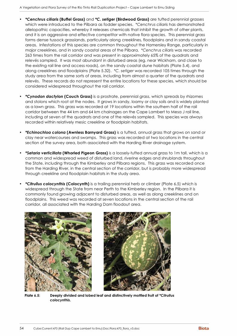
A Vegetation and Flora Survey of the Rio Tinto Rail Duplication Project – Cape Lambert to Emu Siding
54 Cube:Current:470 (Rail Dup Cape Lambert to Emu):Doc:Flora:470_flora_v3.doc
• *Cenchrus ciliaris (Buffel Grass) and *C. setiger (Birdwood Grass) are tufted perennial grasses which were introduced to the Pilbara as fodder species. *Cenchrus ciliaris has demonstrated allelopathic capacities, whereby it releases chemicals that inhibit the growth of other plants, and it is an aggressive and effective competitor with native flora species. This perennial grass forms dense tussock grasslands, particularly along creeklines, floodplains and in sandy coastal areas. Infestations of this species are common throughout the Hamersley Range, particularly in major creeklines, and in sandy coastal areas of the Pilbara. *Cenchrus ciliaris was recorded 263 times from the rail corridor and was present in approximately 65% of the quadrats and relevés sampled. It was most abundant in disturbed areas (eg. near Wickham, and close to the existing rail line and access roads), on the sandy coastal dune habitats (Plate 5.4), and along creeklines and floodplains (Plate 5.32). *C. setiger was recorded 105 times through the study area from the same sorts of areas, including from almost a quarter of the quadrats and relevés. These records do not represent the entire locations for these species, which should be considered widespread throughout the rail corridor.
• *Cynodon dactylon (Couch Grass) is a prostrate, perennial grass, which spreads by rhizomes
and stolons which root at the nodes. It grows in sandy, loamy or clay soils and is widely planted as a lawn grass. This grass was recorded at 19 locations within the southern half of the rail corridor between the 44 km and 64 km chainages on the Cape Lambert to Mesa J rail line, including at seven of the quadrats and one of the relevés sampled. This species was always recorded within relatively mesic creekline or floodplain habitats.
• *Echinochloa colona (Awnless Barnyard Grass) is a tufted, annual grass that grows on sand or
clay near watercourses and swamps. This grass was recorded at two locations in the central section of the survey area, both associated with the Harding River drainage system.
• *Setaria verticillata (Whorled Pigeon Grass) is a loosely-tufted annual grass to 1m tall, which is a
common and widespread weed of disturbed land, riverine edges and shrublands throughout the State, including through the Kimberley and Pilbara regions. This grass was recorded once from the Harding River, in the central section of the corridor, but is probably more widespread through creekline and floodplain habitats in the study area.
• *Citrullus colocynthis (Colocynth) is a trailing perennial herb or climber (Plate 6.5) which is
widespread through the State from near Perth to the Kimberley region. In the Pilbara it is commonly found growing adjacent to disturbed areas, as well as along creeklines and on floodplains. This weed was recorded at seven locations in the central section of the rail corridor, all associated with the Harding Dam floodout area.
Plate 6.5: Deeply divided and lobed leaf and distinctively mottled fruit of *Citrullus
colocynthis.

A Vegetation and Flora Survey of the Rio Tinto Rail Duplication Project – Cape Lambert to Emu Siding
Cube:Current:470 (Rail Dup Cape Lambert to Emu):Doc:Flora:470_flora_v3.doc 55
• *Cucumis melo subsp. agrestis (Ulcardo Melon) is a widespread weed through the Kimberley and Pilbara regions, extending south into the Gascoyne bioregion. This trailing melon (Plate 6.6) was recorded from 17 locations in the central section of the rail corridor, mainly in the Harding Dam floodout area, with a few records from the Harding River itself and a tributary of this river to the north.
Plate 6.6: *Cucumis melo subsp. agrestis (foreground) with *Cucumis sp. (background).
• *Cucumis sp.: A species of Cucumis was recorded which could not be positively identified, but
is considered likely to be a weed. While there are some apparently equivalent specimens included amongst the *Cucumis melo subsp. agrestis collections at the WA Herbarium, these appear to differ from this species in having more distinctly lobed leaves (Plate 6.6 and Plate 6.7), and larger and broader fruit which are somewhat three or four-sided in cross-section (rather than smoothly oval; see Plate 6.7). This species was recorded between approximately the 19 km and 64 km chainages on the Cape Lambert to Mesa J rail line, occurring in clayey habitats or associated with drainage areas. This species was also recorded from the Emu Siding to Rosella Siding development areas to the south of the current study area (Biota 2008d).
Plate 6.7: *Cucumis sp.: (clockwise from top left): distinctly lobed leaves of *Cucumis
sp. (foreground) compared to *Cucumis melo subsp. agrestis (background); leaves and unripe fruit; seeds; ripe fruit showing purplish blush.

A Vegetation and Flora Survey of the Rio Tinto Rail Duplication Project – Cape Lambert to Emu Siding
56 Cube:Current:470 (Rail Dup Cape Lambert to Emu):Doc:Flora:470_flora_v3.doc
• *Malvastrum americanum (Spiked Malvastrum) is a low shrub / perennial herb, which is widespread through the northern half of WA. In the Pilbara, this species is typically recorded from Mulga vegetation or creekline and floodplain habitats. This weed was recorded at six locations in the survey area between approximately the 25 km and 51 km chainages on the Cape Lambert to Mesa J rail line, and was typically associated with creeklines.
• *Passiflora foetida var. hispida (Stinking Passion Flower) is a common woody climber / vine that
is found in disturbed coastal areas on river and creek banks from the Kimberley to Carnarvon. This climber was recorded at two locations in the northern third of the rail corridor, including a creekline (EMU-MB) and a previously disturbed plain (EMU02).
• *Phyla nodiflora (Lippia) is a spreading perennial herb to 30 cm tall, which is widespread
through WA from Perth to the Kimberley. It is listed on FloraBase as occurring at the margins of wetlands and in coastal dune fields. This species was recorded at a single location in the Harding River, in the central section of the rail corridor.
• *Portulaca oleracea (Purslane / Pigweed) is a succulent, usually prostrate, annual herb, which
grows throughout the State and is common through the Pilbara. It is often found at sites that have been previously disturbed, and prefers sandy or clay-loam soils. The classification of this species on FloraBase has only recently changed from ‘native to WA’ to an introduced/alien status. Purslane was recorded from 87 locations throughout the rail corridor, including several areas which did not appear to have been previously disturbed.
• *Sigesbeckia orientalis (Indian Weed) is a slender herbaceous daisy occurring through the
southern Pilbara, particularly in Mulga vegetation, drainage areas and rocky habitats. This species was recorded from a single location in Western Creek, in the southern section of the rail corridor.
• *Vachellia farnesiana (Mimosa Bush) is a tall spiny shrub which is widespread from the
Kimberley to near Perth, typically occurring along drainage systems and in adjacent low-lying areas. This shrub was recorded at 13 locations in the rail corridor, between the 18 km and 40 km chainages on the Cape Lambert to Mesa J rail line. It was typically associated with clayey plains (particularly drainage areas through these), with one record from the Harding River.

A Vegetation and Flora Survey of the Rio Tinto Rail Duplication Project – Cape Lambert to Emu Siding
Cube:Current:470 (Rail Dup Cape Lambert to Emu):Doc:Flora:470_flora_v3.doc 57
7.0 Summary and Recommendations
7.1 Vegetation of Conservation Significance
Away from historic disturbance areas (eg. the existing rail line and access road corridor, old camp sites, borrow pits, etc), the vegetation types of the Cape Lambert to Emu Siding rail corridor were generally in Very Good to Excellent condition. Exceptions included sections of creekline and floodplain habitats, which were in Poor condition due to extensive invasion by perennial *Cenchrus tussock grasses. While none of the vegetation types identified within the rail corridor are listed under the EPBC Act 1999, nor are any defined as TECs by the DEC, a number were identified as having particular conservation significance (Table 7.1). Two of the vegetation units (H/G and Tw/H) would comprise the “cracking clay communities of the Chichester Range” PEC, while riparian vegetation of the Harding River and other major drainages was also considered to be of High significance. Vegetation of Moderate significance was considered to include mangal (unit AVm), vegetation of cracking clays (principally unit ERAx) and rockpile vegetation (unit TERcTw and AcDIsEHsTwCEc). Disturbance to the vegetation types of High significance should be avoided, and strictly minimised if this is not possible. No non-essential infrastructure should be located in these habitats. Appropriate culverting will also be required where drainage systems are intersected. Disturbance to the vegetation types of Moderate significance should be strictly minimised.
Table 7.1: Summary of vegetation units of particular conservation significance identified during this study.
Vegetation Code Description Conservation Significance
H/G, Tw/H Annual herblands / grasslands and hummock grasslands on cracking clays of the Pyramid Land System
High
EcAamCv, EvMg, EvAtrTeCEc, EvTERcApyTwTeCE, EvApyTwTeCE
Riparian vegetation of the Harding River system and other major drainages
High
AVm Mangrove vegetation dominated by Avicennia marina
Moderate
ERAx Eragrostis xerophila tussock grasslands on clay Moderate
TERcTw, AcDIsEHsTwCEc Rockpile vegetation Moderate
7.2 Flora of Conservation Significance
No Declared Rare Flora species or flora species listed under the EPBC Act 1999 were recorded from the Cape Lambert to Emu Siding rail corridor, and none would be expected to occur. Two Priority flora species were recorded from the rail corridor as summarised in Table 7.2 and mapped in Appendix 3. Disturbance to these Priority flora populations should be avoided in the design and construction of the rail duplication, and clearing of the vegetation type/s supporting them should be minimised.
Table 7.2: Summary of Priority flora species recorded during this study.
Species Ranking Locations in Easting and Northing (WGS84)
Vegetation Type
Nicotiana heterantha Priority 1 509527 mE, 7675320 mN EcEvHAi (also potentially EcEvERAf and floodout mosaic)
509938 mE, 7698715 mN
510844 mE, 7691154 mN
Hibiscus brachysiphonius Priority 3
509536 mE, 7676500 mN
ERAx, AxTwERAxCEc, floodout mosaic

A Vegetation and Flora Survey of the Rio Tinto Rail Duplication Project – Cape Lambert to Emu Siding
58 Cube:Current:470 (Rail Dup Cape Lambert to Emu):Doc:Flora:470_flora_v3.doc
8.0 Acknowledgements Apart from those persons already mentioned in this document, the following are gratefully acknowledged for their assistance with this study:
• Mr Malcolm Trudgen (M.E. Trudgen & Associates) provided confirmation or determination of numerous difficult plant groups (particularly the Malvaceae and Tiliaceae families, and the Tephrosia and Triodia genera).
• Mr Greg Guerin (Plant Identification Officer, WA Herbarium) determined or confirmed several specimens, including Goodenia and Rostellularia specimens.
• Mr Paul Sawers and Mr Luke Lovell (Biota) prepared all mapping in this report.

A Vegetation and Flora Survey of the Rio Tinto Rail Duplication Project – Cape Lambert to Emu Siding
Cube:Current:470 (Rail Dup Cape Lambert to Emu):Doc:Flora:470_flora_v3.doc 59
9.0 References Aplin, T.E.H. (1979). The Flora. Chapter 3 In O'Brien, B.J. (ed.) (1979). Environment and Science.
University of Western Australia Press.
Atkins, K.J.A. (2008). Declared Rare and Priority Flora List for Western Australia. Department of Environment and Conservation, 26 February 2008.
Beard, J.S. (1975). Vegetation Survey of Western Australia. 1:100,000 Vegetation Series Map sheet 5 - Pilbara.
Biota Environmental Sciences (2006). A vegetation and flora survey of the proposed Mesa A Transport Corridor, Warramboo Deposit and Yarraloola Borefield. Unpublished report prepared for Robe River Iron Associates, January 2006.
Biota Environmental Sciences (2008a). Cape Lambert Port B Development: Flora and Vegetation Survey. Unpublished report prepared for Pilbara Iron Pty Ltd, July 2008.
Biota Environmental Sciences (2008b). Pilbara Power System Upgrade Additional Areas: Native Vegetation Clearing Permit Report. Unpublished report prepared for Pilbara Iron, May 2008.
Biota Environmental Sciences (2008c). Karratha to Cape Lambert Transmission Line Corridor: Native Vegetation Clearing Permit Report. Unpublished report prepared for Rio Tinto Iron Ore, July 2008.
Biota Environmental Sciences (2008d). A Vegetation and Flora Survey of the Rio Tinto Rail Duplication – Emu Siding to Rosella Siding Development Areas. Unpublished report prepared for Rio Tinto Iron Ore, August 2008.
Biota Environmental Sciences (2008e). A Vegetation and Flora Survey of the Rio Tinto Rail Duplication – Bellbird Siding to Juna Downs. Unpublished report prepared for Rio Tinto Iron Ore, August 2008.
Environment Australia (2000). Revision of the Interim Biogeographic Regionalisation for Australia (IBRA) and Development of Version 5.1, Summary Report. Environment Australia, November 2000.
Kendrick, P. and F. Stanley (2001). Pilbara 4 (PIL4 – Roebourne synopsis). Pp 581-594 in May, J.E. and N.L. McKenzie (2003). A Biodiversity Audit of Western Australia’s Biogeographical Subregions in 2002. Department of Conservation and Land Management, Perth.
Kendrick, P. and N. McKenzie (2001). Pilbara 1 (PIL1 – Chichester subregion). Pp 547-558 in May, J.E. and N.L. McKenzie (2003). A Biodiversity Audit of Western Australia’s Biogeographical Subregions in 2002. Department of Conservation and Land Management, Perth.
May, J.E. and N.L. McKenzie (2003). A Biodiversity Audit of Western Australia’s Biogeographical Subregions in 2002. Department of Conservation and Land Management, Perth.
Randell, B.R. (1989). Revision of the Cassiinae in Australia. 2. Senna Miller Sect. Psilorhegma (J. Vogel) Irwin and Barneby. J. Adelaide Bot. Gard. 12(2): 165-272.
Specht, R.L. (1970). Vegetation. In G.W. Leeper (ed). The Australian Environment. 4th edn. Melbourne.
Symon, D.E. (1966). A revision of the genus Cassia L. Caesalpiniaceae in Australia. Trans. Roy. Soc. S. Australia 90: 73-146.
Trudgen, M.E. (1988). A Report on the Flora and Vegetation of the Port Kennedy Area. Unpublished report prepared for Bowman Bishaw and Associates, West Perth.

A Vegetation and Flora Survey of the Rio Tinto Rail Duplication Project – Cape Lambert to Emu Siding
60 Cube:Current:470 (Rail Dup Cape Lambert to Emu):Doc:Flora:470_flora_v3.doc
Trudgen, M.E. and N. Casson (1998). Flora and vegetation surveys of Orebody A and Orebody B in the West Angela Hill area, an area surrounding them, and of rail route options considered to link them to the existing Robe River Iron Associates rail line. Unpublished report for Robe River Iron Associates.
van Leeuwen, S. and B. Bromilow (2002). Botanical Survey of Hamersley Range Uplands. National Reserve System Project N709 Final Report – May 2002. Unpublished report prepared by the Department of Conservation and Land Management, Science Division.
van Vreeswyk, A.M.E., A.L. Payne, K.A. Leighton and P. Hennig (2004). An inventory and condition survey of the Pilbara region, Western Australia. Department of Agriculture Technical Bulletin No. 92, December 2004.

A Vegetation and Flora Survey of the Rio Tinto Rail Duplication Project – Cape Lambert to Emu Siding
Cube:Current:470 (Rail Dup Cape Lambert to Emu):Doc:Flora:470_flora_v3.doc
Appendix 1
Framework for Conservation Significance Ranking of Communities
and Species


A Vegetation and Flora Survey of the Rio Tinto Rail Duplication Project – Cape Lambert to Emu Siding
Cube:Current:470 (Rail Dup Cape Lambert to Emu):Doc:Flora:470_flora_v3.doc
A. Definitions, Categories and Criteria for Threatened and Priority Ecological Communities 1. General Definitions Ecological Community A naturally occurring biological assemblage that occurs in a particular type of habitat. Note: The scale at which ecological communities are defined will often depend on the level of detail in the information source, therefore no particular scale is specified. A threatened ecological community (TEC) is one which is found to fit into one of the following categories; “presumed totally destroyed”, “critically endangered”, “endangered” or “vulnerable”. Possible threatened ecological communities that do not meet survey criteria are added to DEC’s Priority Ecological Community Lists under Priorities 1, 2 and 3. Ecological Communities that are adequately known, are rare but not threatened, or meet criteria for Near Threatened, or that have been recently removed from the threatened list, are placed in Priority 4. These ecological communities require regular monitoring. Conservation Dependent ecological communities are placed in Priority 5. An assemblage is a defined group of biological entities. Habitat is defined as the areas in which an organism and/or assemblage of organisms lives. It includes the abiotic factors (eg. substrate and topography), and the biotic factors. Occurrence: a discrete example of an ecological community, separated from other examples of the same community by more than 20 metres of a different ecological community, an artificial surface or a totally destroyed community. By ensuring that every discrete occurrence is recognised and recorded future changes in status can be readily monitored. Adequately Surveyed is defined as follows: “An ecological community that has been searched for thoroughly in most likely habitats, by relevant experts.” Community structure is defined as follows: “The spatial organisation, construction and arrangement of the biological elements comprising a biological assemblage” (eg. Eucalyptus salmonophloia woodland over scattered small shrubs over dense herbs; structure in a faunal assemblage could refer to trophic structure, eg. dominance by feeders on detritus as distinct from feeders on live plants). Definitions of Modification and Destruction of an ecological community: Modification: “changes to some or all of ecological processes (including abiotic processes such as hydrology), species composition and community structure as a direct or indirect result of human activities. The level of damage involved could be ameliorated naturally or by human intervention.” Destruction: “modification such that reestablishment of ecological processes, species composition and community structure within the range of variability exhibited by the original community is unlikely within the foreseeable future even with positive human intervention.” Note: Modification and destruction are difficult concepts to quantify, and their application will be determined by scientific judgement. Examples of modification and total destruction are cited below: Modification of ecological processes: The hydrology of Toolibin Lake has been altered by clearing of the catchment such that death of some of the original flora has occurred due to dependence on fresh water. The system may be bought back to a semblance of the original state by redirecting saline runoff and pumping waters of the rising underground watertable away to restore the hydrological balance. Total destruction of downstream lakes has occurred due to hydrology being altered to the point that few of the original flora or fauna species are able to tolerate the level of salinity and/or water logging. Modification of structure: The understorey of a plant community may be altered by weed invasion due to nutrient enrichment by addition of fertiliser. Should the additional nutrients be removed from the system the balance may be restored, and the original plant species better able to compete. Total destruction may occur if additional nutrients continue to be added to the system causing the understorey to be completely replaced by weed species, and death of overstorey species due to inability to tolerate high nutrient levels.
A Vegetation and Flora Survey of the Rio Tinto Rail Duplication Project – Cape Lambert to Emu Siding
Cube:Current:470 (Rail Dup Cape Lambert to Emu):Doc:Flora:470_flora_v3.doc
Modification of species composition: Pollution may cause alteration of the invertebrate species present in a freshwater lake. Removal of pollutants may allow the return of the original inhabitant species. Addition of residual highly toxic substances may cause permanent changes to water quality, and total destruction of the community. Threatening processes are defined as follows: “Any process or activity that threatens to destroy or significantly modify the ecological community and/or affect the continuing evolutionary processes within any ecological community.” Examples of some of the continuing threatening processes in Western Australia include: general pollution; competition, predation and change induced in ecological communities as a result of introduced animals; competition and displacement of native plants by introduced species; hydrological changes; inappropriate fire regimes; diseases resulting from introduced micro-organisms; direct human exploitation and disturbance of ecological communities. Restoration is defined as returning an ecological community to its pre-disturbance or natural state in terms of abiotic conditions, community structure and species composition. Rehabilitation is defined as the re-establishment of ecological attributes in a damaged ecological community although the community will remain modified. 2. Definitions and Criteria for Presumed Totally Destroyed, Critically Endangered, Endangered and
Vulnerable Ecological Communities ECOLOGICAL COMMUNITIES Presumed Totally Destroyed (PD) An ecological community that has been adequately searched for but for which no representative occurrences have been located. The community has been found to be totally destroyed or so extensively modified throughout its range that no occurrence of it is likely to recover its species composition and/or structure in the foreseeable future. An ecological community will be listed as presumed totally destroyed if there are no recent records of the community being extant and either of the following applies ( A or B):
A) Records within the last 50 years have not been confirmed despite thorough searches of known or likely habitats or
B) All occurrences recorded within the last 50 years have since been destroyed Critically Endangered (CR) An ecological community that has been adequately surveyed and found to have been subject to a major contraction in area and/or that was originally of limited distribution and is facing severe modification or destruction throughout its range in the immediate future, or is already severely degraded throughout its range but capable of being substantially restored or rehabilitated. An ecological community will be listed as Critically Endangered when it has been adequately surveyed and is found to be facing an extremely high risk of total destruction in the immediate future. This will be determined on the basis of the best available information, by it meeting any one or more of the following criteria (A, B or C):
A) The estimated geographic range, and/or total area occupied, and/or number of discrete occurrences since European settlement have been reduced by at least 90% and either or both of the following apply (i or ii):
i) geographic range, and/or total area occupied and/or number of discrete occurrences are continuing to decline such that total destruction of the community is imminent (within approximately 10 years);
ii) modification throughout its range is continuing such that in the immediate future (within approximately 10 years) the community is unlikely to be capable of being substantially rehabilitated.
B) Current distribution is limited, and one or more of the following apply (i, ii or iii):
i) geographic range and/or number of discrete occurrences, and/or area occupied is highly restricted and the community is currently subject to known threatening processes which are likely to result in total destruction throughout its range in the immediate future (within approximately 10 years);
A Vegetation and Flora Survey of the Rio Tinto Rail Duplication Project – Cape Lambert to Emu Siding
Cube:Current:470 (Rail Dup Cape Lambert to Emu):Doc:Flora:470_flora_v3.doc
ii) there are very few occurrences, each of which is small and/or isolated and extremely vulnerable to known threatening processes;
iii) there may be many occurrences but total area is very small and each occurrence is small and/or isolated and extremely vulnerable to known threatening processes.
C) The ecological community exists only as highly modified occurrences that may be capable of being rehabilitated if such work begins in the immediate future (within approximately 10 years).
Endangered (EN) An ecological community that has been adequately surveyed and found to have been subject to a major contraction in area and/or was originally of limited distribution and is in danger of significant modification throughout its range or severe modification or destruction over most of its range in the near future. An ecological community will be listed as Endangered when it has been adequately surveyed and is not Critically Endangered but is facing a very high risk of total destruction in the near future. This will be determined on the basis of the best available information by it meeting any one or more of the following criteria (A, B, or C):
A) The geographic range, and/or total area occupied, and/or number of discrete occurrences have been reduced by at least 70% since European settlement and either or both of the following apply (i or ii):
i) the estimated geographic range, and/or total area occupied and/or number of discrete occurrences are continuing to decline such that total destruction of the community is likely in the short term future (within approximately 20 years);
ii) modification throughout its range is continuing such that in the short term future (within approximately 20 years) the community is unlikely to be capable of being substantially restored or rehabilitated.
B) Current distribution is limited, and one or more of the following apply (i, ii or iii):
i) geographic range and/or number of discrete occurrences, and/or area occupied is highly restricted and the community is currently subject to known threatening processes which are likely to result in total destruction throughout its range in the short term future (within approximately 20 years);
ii) there are few occurrences, each of which is small and/or isolated and all or most occurrences are very vulnerable to known threatening processes;
iii) there may be many occurrences but total area is small and all or most occurrences are small and/or isolated and very vulnerable to known threatening processes.
C) The ecological community exists only as very modified occurrences that may be capable of being substantially restored or rehabilitated if such work begins in the short-term future (within approximately 20 years).
Vulnerable (VU) An ecological community that has been adequately surveyed and is found to be declining and/or has declined in distribution and/or condition and whose ultimate security has not yet been assured and/or a community that is still widespread but is believed likely to move into a category of higher threat in the near future if threatening processes continue or begin operating throughout its range. An ecological community will be listed as Vulnerable when it has been adequately surveyed and is not Critically Endangered or Endangered but is facing a high risk of total destruction or significant modification in the medium to long-term future. This will be determined on the basis of the best available information by it meeting any one or more of the following criteria (A, B or C):
A) The ecological community exists largely as modified occurrences that are likely to be capable of being substantially restored or rehabilitated.
B) The ecological community may already be modified and would be vulnerable to threatening processes, is restricted in area and/or range and/or is only found at a few locations.
C) The ecological community may be still widespread but is believed likely to move into a category of higher threat in the medium to long term future because of existing or impending threatening processes.

A Vegetation and Flora Survey of the Rio Tinto Rail Duplication Project – Cape Lambert to Emu Siding
Cube:Current:470 (Rail Dup Cape Lambert to Emu):Doc:Flora:470_flora_v3.doc
3. Definitions and Criteria for Priority Ecological Communities PRIORITY ECOLOGICAL COMMUNITY LIST Possible threatened ecological communities that do not meet survey criteria or that are not adequately defined are added to the Priority Ecological Community Lists under Priorities 1, 2 and 3. These three categories are ranked in order of priority for survey and/or definition of the community, and evaluation of conservation status, so that consideration can be given to their declaration as threatened ecological communities. Ecological Communities that are adequately known, and are rare but not threatened or meet criteria for Near Threatened, or that have been recently removed from the threatened list, are placed in Priority 4. These ecological communities require regular monitoring. Conservation Dependent ecological communities are placed in Priority 5. Priority One: Poorly-known ecological communities Ecological communities with apparently few, small occurrences, all or most not actively managed for conservation (e.g. within agricultural or pastoral lands, urban areas, active mineral leases) and for which current threats exist. Communities may be included if they are comparatively well-known from one or more localities but do not meet adequacy of survey requirements, and/or are not well defined, and appear to be under immediate threat from known threatening processes across their range. Priority Two: Poorly-known ecological communities Communities that are known from few small occurrences, all or most of which are actively managed for conservation (e.g. within national parks, conservation parks, nature reserves, State forest, unallocated Crown land, water reserves, etc.) and not under imminent threat of destruction or degradation. Communities may be included if they are comparatively well known from one or more localities but do not meet adequacy of survey requirements, and/or are not well defined, and appear to be under threat from known threatening processes. Priority Three: Poorly known ecological communities
(i) Communities that are known from several to many occurrences, a significant number or area of which are not under threat of habitat destruction or degradation or:
(ii) communities known from a few widespread occurrences, which are either large or within significant remaining areas of habitat in which other occurrences may occur, much of it not under imminent threat, or;
(iii) communities made up of large, and/or widespread occurrences, that may or not be represented in the reserve system, but are under threat of modification across much of their range from processes such as grazing by domestic and/or feral stock, and inappropriate fire regimes.
Communities may be included if they are comparatively well known from several localities but do not meet adequacy of survey requirements and/or are not well defined, and known threatening processes exist that could affect them. Priority Four: Ecological communities that are adequately known, rare but not threatened or meet criteria for Near Threatened, or that have been recently removed from the threatened list. These communities require regular monitoring.
(a) Rare. Ecological communities known from few occurrences that are considered to have been adequately surveyed, or for which sufficient knowledge is available, and that are considered not currently threatened or in need of special protection, but could be if present circumstances change. These communities are usually represented on conservation lands.
(b) Near Threatened. Ecological communities that are considered to have been adequately surveyed and that do not qualify for Conservation Dependent, but that are close to qualifying for Vulnerable.
(c) Ecological communities that have been removed from the list of threatened communities during the past five years.
Priority Five: Conservation Dependent ecological communities Ecological communities that are not threatened but are subject to a specific conservation program, the cessation of which would result in the community becoming threatened within five years. Reference: Department of Environment and Conservation 2007.
A Vegetation and Flora Survey of the Rio Tinto Rail Duplication Project – Cape Lambert to Emu Siding
Cube:Current:470 (Rail Dup Cape Lambert to Emu):Doc:Flora:470_flora_v3.doc
B. Threatened Flora Statutory Framework In Western Australia, all native flora species are protected under the Wildlife Conservation Act 1950-1979, making it an offence to remove or harm native flora species without approval. In addition to this basic level of statutory protection, a number of plant species are assigned an additional level of conservation significance based on the fact that there are a limited number of known populations, some of which may be under threat. Species of the highest conservation significance are designated Declared Rare Flora (DRF), either extant or presumed extinct:
• X: Declared Rare Flora - Presumed Extinct: taxa which have not been collected, or otherwise verified, over the past 50 years despite thorough searching, or of which all known wild populations have been destroyed more recently, and have been gazetted as such, following approval by the Minister for the Environment, after recommendation by the State’s Endangered Flora Consultative Committee;
• R: Declared Rare Flora - Extant: taxa which have been adequately searched for, and are deemed to be in the wild either rare, in danger of extinction, or otherwise in need of special protection, and have been gazetted as such, following approval by the Minister for the Environment, after recommendation by the State’s Endangered Flora Consultative Committee (Atkins 2008). ( = Threatened Flora = Endangered + Vulnerable)
Species that appear to be rare or threatened, but for which there is insufficient information to properly evaluate their conservation significance, are assigned to one of four Priority flora categories:
• P1: Priority One - Poorly Known: taxa which are known from one or a few (generally <5) populations which are under threat, either due to small population size, or being on lands under immediate threat, e.g. road verges, urban areas, farmland, active mineral leases, etc., or the plants are under threat, e.g. from disease, grazing by feral animals, etc. May include taxa with threatened populations on protected lands. Such taxa are under consideration for declaration as ‘rare flora’, but are in urgent need of further survey.
• P2: Priority Two - Poorly Known: taxa which are known from one or a few (generally <5) populations, at least some of which are not believed to be under immediate threat (i.e. not currently endangered). Such taxa are under consideration for declaration as ‘rare flora’, but are in urgent need of further survey.
• P3: Priority Three - Poorly Known: taxa which are known from several populations, at least some of which are not believed to be under immediate threat (i.e. not currently endangered). Such taxa are under consideration for declaration as ‘rare flora’, but are in need of further survey.
• P4: Priority Four - Rare: taxa which are considered to have been adequately surveyed and which, whilst being rare (in Australia), are not currently threatened by any identifiable factors. These taxa require monitoring every 5–10 years.
Note that of the above classifications, only ‘Declared Rare Flora’ has statutory standing. The Priority Flora classifications are employed by the Department of Environment and Conservation to manage and classify their database of species considered potentially rare or at risk, but these categories have no legislative status. Note also that proposals that appear likely to affect DRF require formal written approval from the Minister for the Environment under Section 23(f) of the Wildlife Conservation Act 1950-1979 in addition to the requirements of the Environmental Protection (Native Vegetation Clearing) Regulations 2004. References: Atkins, K.J. (2008). Declared Rare and Priority Flora List for Western Australia. Prepared by the Department of Environment and Conservation, 26 February 2008.

A Vegetation and Flora Survey of the Rio Tinto Rail Duplication Project – Cape Lambert to Emu Siding
Cube:Current:470 (Rail Dup Cape Lambert to Emu):Doc:Flora:470_flora_v3.doc
Appendix 2
Vegetation Structural Classification and Condition Ranking Scale

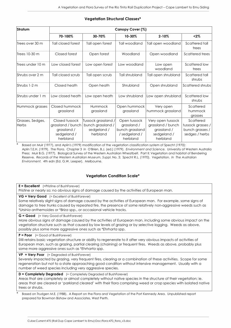
A Vegetation and Flora Survey of the Rio Tinto Rail Duplication Project – Cape Lambert to Emu Siding
Cube:Current:470 (Rail Dup Cape Lambert to Emu):Doc:Flora:470_flora_v3.doc
Vegetation Structural Classes*
Canopy Cover (%) Stratum
70-100% 30-70% 10-30% 2-10% <2%
Trees over 30 m Tall closed forest Tall open forest Tall woodland Tall open woodland Scattered tall trees
Trees 10-30 m Closed forest Open forest Woodland Open woodland Scattered trees
Trees under 10 m Low closed forest Low open forest Low woodland Low open woodland
Scattered low trees
Shrubs over 2 m Tall closed scrub Tall open scrub Tall shrubland Tall open shrubland Scattered tall shrubs
Shrubs 1-2 m Closed heath Open heath Shrubland Open shrubland Scattered shrubs
Shrubs under 1 m Low closed heath Low open heath Low shrubland Low open shrubland Scattered low shrubs
Hummock grasses Closed hummock grassland
Hummock grassland
Open hummock grassland
Very open hummock grassland
Scattered hummock
grasses Grasses, Sedges, Herbs
Closed tussock grassland / bunch
grassland / sedgeland /
herbland
Tussock grassland / bunch grassland /
sedgeland / herbland
Open tussock grassland /
bunch grassland / sedgeland /
herbland
Very open tussock grassland / bunch
grassland / sedgeland /
herbland
Scattered tussock grasses / bunch grasses / sedges / herbs
* Based on Muir (1977), and Aplin's (1979) modification of the vegetation classification system of Specht (1970): Aplin T.E.H. (1979). The Flora. Chapter 3 In O'Brien, B.J. (ed.) (1979). Environment and Science. University of Western Australia Press; Muir B.G. (1977). Biological Survey of the Western Australian Wheatbelt. Part II: Vegetation and habitat of Bendering Reserve. Records of the Western Australian Museum, Suppl. No. 3; Specht R.L. (1970). Vegetation. In The Australian Environment. 4th edn (Ed. G.W. Leeper). Melbourne.
Vegetation Condition Scale*
E = Excellent (=Pristine of BushForever) Pristine or nearly so; no obvious signs of damage caused by the activities of European man.
VG = Very Good (= Excellent of BushForever) Some relatively slight signs of damage caused by the activities of European man. For example, some signs of damage to tree trunks caused by repeated fire, the presence of some relatively non-aggressive weeds such as *Ursinia anthemoides or *Briza spp., or occasional vehicle tracks.
G = Good (= Very Good of BushForever) More obvious signs of damage caused by the activities of European man, including some obvious impact on the vegetation structure such as that caused by low levels of grazing or by selective logging. Weeds as above, possibly plus some more aggressive ones such as *Ehrharta spp.
P = Poor (= Good of BushForever) Still retains basic vegetation structure or ability to regenerate to it after very obvious impacts of activities of European man, such as grazing, partial clearing (chaining) or frequent fires. Weeds as above, probably plus some more aggressive ones such as *Ehrharta spp.
VP = Very Poor (= Degraded of BushForever) Severely impacted by grazing, very frequent fires, clearing or a combination of these activities. Scope for some regeneration but not to a state approaching good condition without intensive management. Usually with a number of weed species including very aggressive species.
D = Completely Degraded (= Completely Degraded of BushForever) Areas that are completely or almost completely without native species in the structure of their vegetation; ie. areas that are cleared or ‘parkland cleared’ with their flora comprising weed or crop species with isolated native trees or shrubs.
* Based on Trudgen M.E. (1988). A Report on the Flora and Vegetation of the Port Kennedy Area. Unpublished report prepared for Bowman Bishaw and Associates, West Perth.


A Vegetation and Flora Survey of the Rio Tinto Rail Duplication Project – Cape Lambert to Emu Siding
Cube:Current:470 (Rail Dup Cape Lambert to Emu):Doc:Flora:470_flora_v3.doc
Appendix 3
Vegetation Types, Priority Flora Locations and Weed Locations Recorded within
the Study Area


A Vegetation and Flora Survey of the Rio Tinto Rail Duplication Project – Cape Lambert to Emu Siding
Cube:Current:470 (Rail Dup Cape Lambert to Emu):Doc:Flora:470_flora_v3.doc

A Vegetation and Flora Survey of the Rio Tinto Rail Duplication Project – Cape Lambert to Emu Siding
Cube:Current:470 (Rail Dup Cape Lambert to Emu):Doc:Flora:470_flora_v3.doc
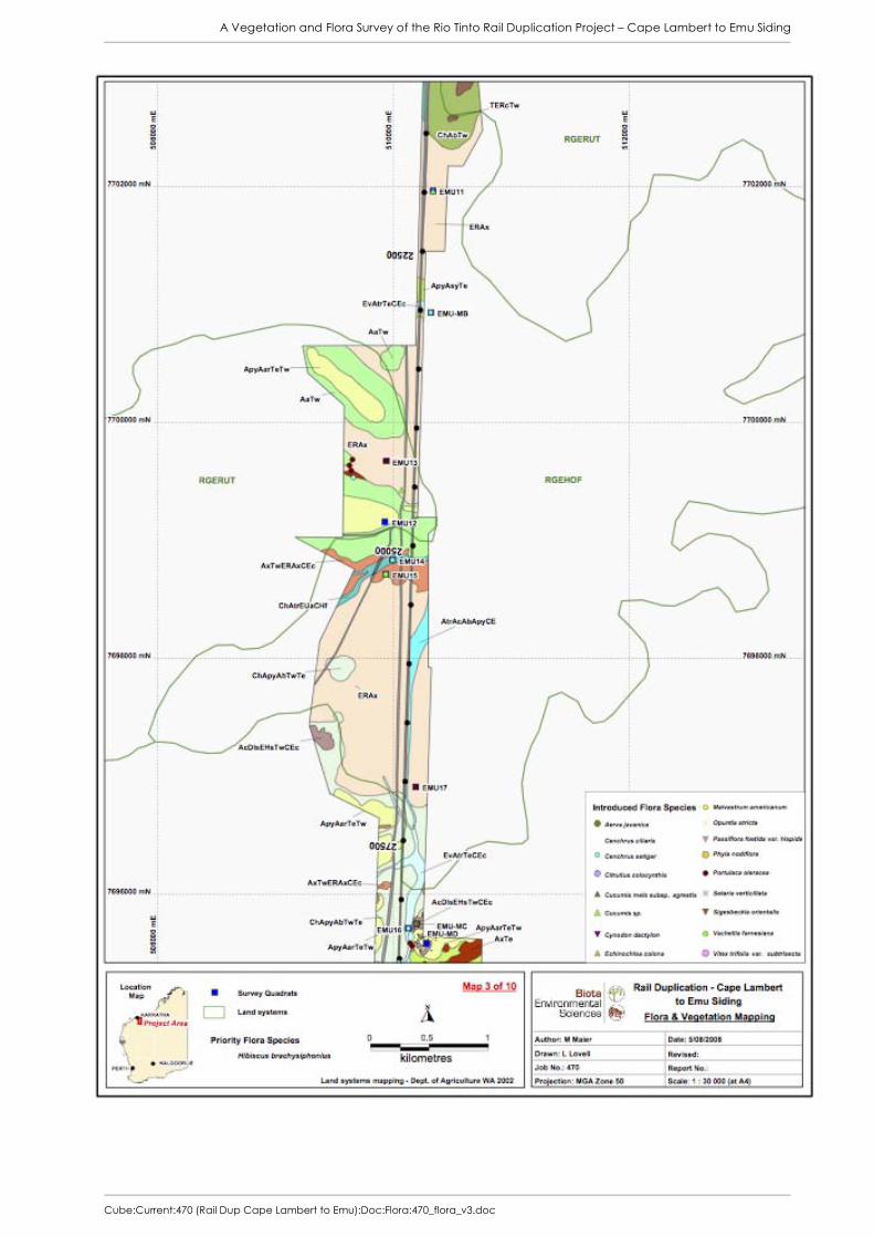
A Vegetation and Flora Survey of the Rio Tinto Rail Duplication Project – Cape Lambert to Emu Siding
Cube:Current:470 (Rail Dup Cape Lambert to Emu):Doc:Flora:470_flora_v3.doc

A Vegetation and Flora Survey of the Rio Tinto Rail Duplication Project – Cape Lambert to Emu Siding
Cube:Current:470 (Rail Dup Cape Lambert to Emu):Doc:Flora:470_flora_v3.doc

A Vegetation and Flora Survey of the Rio Tinto Rail Duplication Project – Cape Lambert to Emu Siding
Cube:Current:470 (Rail Dup Cape Lambert to Emu):Doc:Flora:470_flora_v3.doc

A Vegetation and Flora Survey of the Rio Tinto Rail Duplication Project – Cape Lambert to Emu Siding
Cube:Current:470 (Rail Dup Cape Lambert to Emu):Doc:Flora:470_flora_v3.doc

A Vegetation and Flora Survey of the Rio Tinto Rail Duplication Project – Cape Lambert to Emu Siding
Cube:Current:470 (Rail Dup Cape Lambert to Emu):Doc:Flora:470_flora_v3.doc

A Vegetation and Flora Survey of the Rio Tinto Rail Duplication Project – Cape Lambert to Emu Siding
Cube:Current:470 (Rail Dup Cape Lambert to Emu):Doc:Flora:470_flora_v3.doc
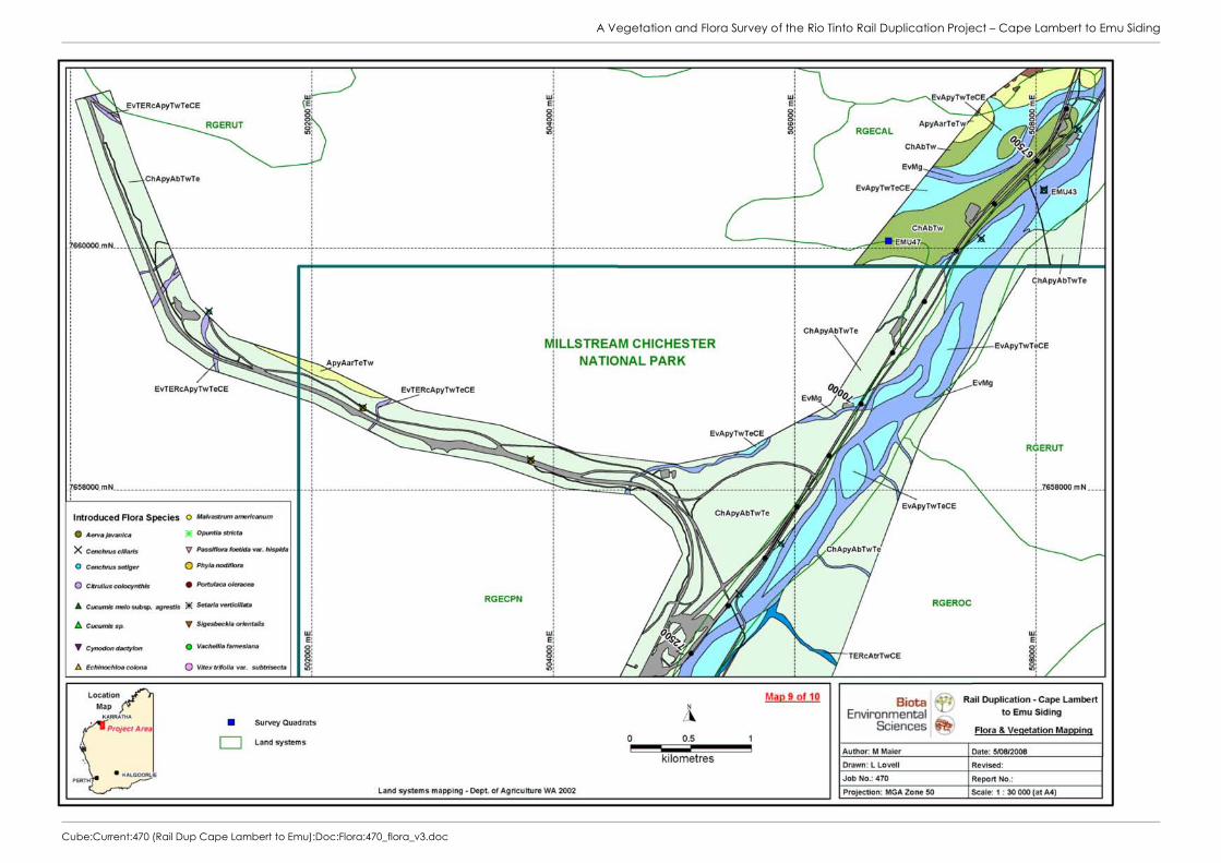
A Vegetation and Flora Survey of the Rio Tinto Rail Duplication Project – Cape Lambert to Emu Siding
Cube:Current:470 (Rail Dup Cape Lambert to Emu):Doc:Flora:470_flora_v3.doc

A Vegetation and Flora Survey of the Rio Tinto Rail Duplication Project – Cape Lambert to Emu Siding
Cube:Current:470 (Rail Dup Cape Lambert to Emu):Doc:Flora:470_flora_v3.doc
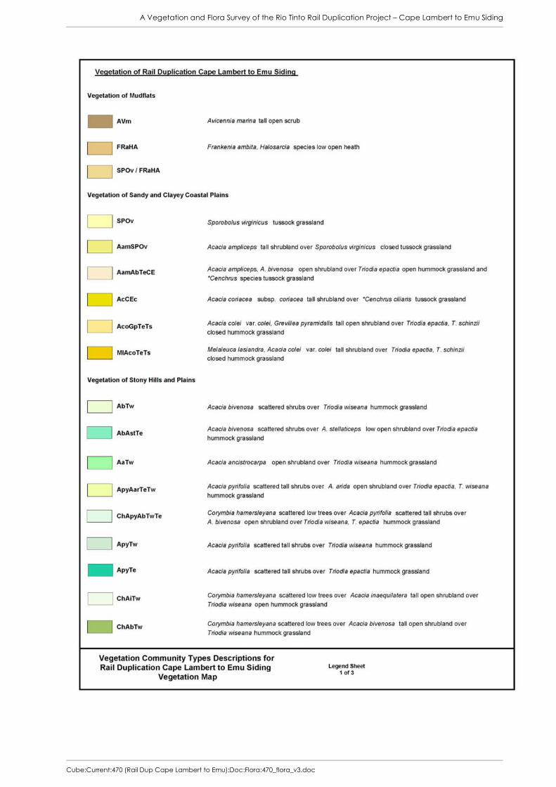
A Vegetation and Flora Survey of the Rio Tinto Rail Duplication Project – Cape Lambert to Emu Siding
Cube:Current:470 (Rail Dup Cape Lambert to Emu):Doc:Flora:470_flora_v3.doc

A Vegetation and Flora Survey of the Rio Tinto Rail Duplication Project – Cape Lambert to Emu Siding
Cube:Current:470 (Rail Dup Cape Lambert to Emu):Doc:Flora:470_flora_v3.doc

A Vegetation and Flora Survey of the Rio Tinto Rail Duplication Project – Cape Lambert to Emu Siding
Cube:Current:470 (Rail Dup Cape Lambert to Emu):Doc:Flora:470_flora_v3.doc


A Vegetation and Flora Survey of the Rio Tinto Rail Duplication Project – Cape Lambert to Emu Siding
Cube:Current:470 (Rail Dup Cape Lambert to Emu):Doc:Flora:470_flora_v3.doc
Appendix 4
Raw Data from Quadrats and Relevés Assessed in the Study Area


A Vegetation and Flora Survey of the Rio Tinto Rail Duplication Project – Cape Lambert to Emu Siding
Cube:Current:470 (Rail Dup Cape Lambert to Emu):Doc:Flora:470_flora_v3.doc
PI Rail Cape Lambert to Emu Siding Site EMU01 Described by RWJCF Date 4/01/2008 Type Q 50x50m MGA Zone 50 511750 mE 7712458 mN Habitat Rocky hill slope (S-facing) Soil Red-brown clay loam Rock Type Ironstone cobbles Vegetation Acacia arida open shrubland over Triodia epactia (T. wiseana) hummock grassland Veg Condition Excellent Fire Age > 5 years PI Rail Cape Lambert to Emu Siding Site EMU02 Described by JA Date 4/01/2008 Type Q 50x50m MGA Zone 50 511854 mE 7712642 mN Habitat Stony foothills; sloping slightly to north Soil Red clay-loam Vegetation Eucalyptus victrix scattered low trees over Acacia inaequilatera tall open shrubland over
Acacia bivenosa open shrubland over *Cenchrus ciliaris tussock grassland and Triodia epactia open hummock grassland.
Veg Condition Very Poor Fire Age No evidence of recent fire Notes Area has been seriously disturbed; earthworks, possible old building structures, dumped
blue metal, weeds. Lots of rubbish. PI Rail Cape Lambert to Emu Siding Site EMU03 Described by RWJCF Date 4/01/2008 Type Q 50x50m MGA Zone 50 510518 mE 7712144 mN Habitat Hillslope Soil Red-brown clay loam Rock Type Calcrete and ironstone pebbles and cobbles Vegetation Acacia arida tall shrubland over Triodia epactia, T. wiseana closed hummock grassland Veg Condition Excellent Fire Age > 5 years PI Rail Cape Lambert to Emu Siding Site EMU04 Described by JA/MM Date 4/01/2008 Type Q 50x50m MGA Zone 50 510566 mE 7712275 mN Habitat Footslope Soil Orange-red loam Rock Type Chert and ironstone, some quartz. Vegetation Acacia pyrifolia low open woodland over A. bivenosa, A. elachantha scattered shrubs
over Triodia epactia, T. wiseana closed hummock grassland Veg Condition Very good Fire Age No signs of fire PI Rail Cape Lambert to Emu Siding Site EMU05 Described by RWJCF Date 4/02/2008 Type Q 50x50m MGA Zone 50 510123 mE 7708940 mN Habitat Slope of a low hill Soil Red-brown clay loam Rock Type Shale / ironstone Vegetation Acacia bivenosa (A. pyrifolia, A. synchronicia, A. arida) open shrubland over Triodia
wiseana, T. epactia hummock grassland Veg Condition Very good Fire Age Burnt 3-5 years ago PI Rail Cape Lambert to Emu Siding Site EMU06 Described by JA Date 4/02/2008 Type Q 50x50m MGA Zone 50 510217 mE 7709810 mN Habitat Low flat foothills; gentle SW slope. Soil Dark red loam Rock Type Ironstone and chert Vegetation Corymbia hamersleyana scattered low trees over Acacia stellaticeps, A. bivenosa open
shrubland over Triodia epactia, T. wiseana hummock grassland Veg Condition Very good Fire Age No evidence of fire Notes Coordinates not recorded at time of survey; estimated from aerial photography.

A Vegetation and Flora Survey of the Rio Tinto Rail Duplication Project – Cape Lambert to Emu Siding
Cube:Current:470 (Rail Dup Cape Lambert to Emu):Doc:Flora:470_flora_v3.doc
PI Rail Cape Lambert to Emu Siding Site EMU07 Described by RWJCF Date 4/02/2008 Type Q 200x12.5m MGA Zone 50 509986 mE 7707869 mN Habitat Creekline in valley Soil Brown clay loam Vegetation Corymbia hamersleyana low open woodland over Acacia tumida var. pilbarensis tall
closed scrub over Triodia epactia very open hummock grassland and *Cenchrus ciliaris, *C. setiger open tussock grassland
Veg Condition Very Good Fire Age Burnt >3 years ago PI Rail Cape Lambert to Emu Siding Site EMU08 Described by JA Date 4/02/2008 Type Q 50x50m MGA Zone 50 510460 mE 7705613 mN Habitat Flat plain, draining east Soil Red-brown loam Vegetation Acacia pyrifolia scattered shrubs over A. synchronicia scattered low shrubs over Triodia
epactia hummock grassland. Veg Condition Very Good Fire Age No evidence of recent fire PI Rail Cape Lambert to Emu Siding Site EMU09 Described by RWJCF Date 4/02/2008 Type Q 25x100m MGA Zone 50 510442 mE 7705835 mN Habitat Creekline Soil Red-brown clay loam Vegetation Corymbia hamersleyana low open woodland over Acacia tumida, A. pyrifolia tall open
scrub over Triodia epactia open hummock grassland over *Cenchrus ciliaris, *C. setiger, Cymbopogon procerus tussock grassland
Veg Condition Good; large amount of Buffel Grass on the banks Fire Age Burnt >5 years ago PI Rail Cape Lambert to Emu Siding Site EMU10 Described by JA Date 4/02/2008 Type Q 50x50m MGA Zone 50 510394 mE 7704867 mN Habitat Gently sloping plain Soil Red-brown clay loam Rock Type Quartz pebbles on surface Vegetation Eragrostis xerophila tussock grassland and Operculina aequisepala very open herbland Veg Condition Very good Fire Age No sign of fire Notes No emergent rocks; deep crabholes PI Rail Cape Lambert to Emu Siding Site EMU11 Described by RWJCF Date 4/02/2008 Type Q 50x50m MGA Zone 50 510357 mE 7701992 mN Habitat Plain Soil Red-brown clay Rock Type Alluvial ironstone pebbles Vegetation Eragrostis xerophila, Eriachne flaccida tussock grassland Veg Condition Excellent Fire Age No sign of fire Notes Water pooling in low lying areas. Very muddy. PI Rail Cape Lambert to Emu Siding Site EMU12 Described by JA/MM Date 4/03/2008 Type Q 50x50m MGA Zone 50 509913 mE 7699128 mN Habitat Rocky hill slope Soil Orange-brown clay loam Rock Type Quartz and ironstone Vegetation Acacia arida low open woodland over Triodia wiseana hummock grassland Veg Condition Very good; some Cenchrus ciliaris outside quadrat Fire Age Long unburnt, possibly >10 years
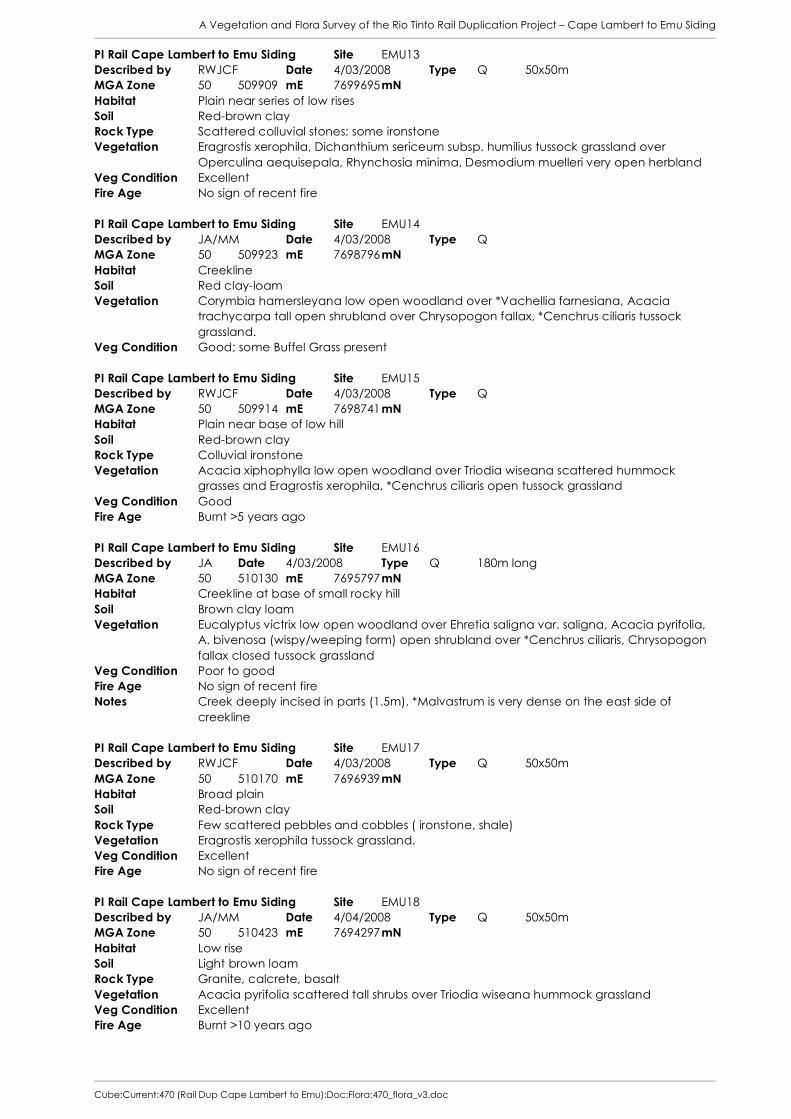
A Vegetation and Flora Survey of the Rio Tinto Rail Duplication Project – Cape Lambert to Emu Siding
Cube:Current:470 (Rail Dup Cape Lambert to Emu):Doc:Flora:470_flora_v3.doc
PI Rail Cape Lambert to Emu Siding Site EMU13 Described by RWJCF Date 4/03/2008 Type Q 50x50m MGA Zone 50 509909 mE 7699695 mN Habitat Plain near series of low rises Soil Red-brown clay Rock Type Scattered colluvial stones; some ironstone Vegetation Eragrostis xerophila, Dichanthium sericeum subsp. humilius tussock grassland over
Operculina aequisepala, Rhynchosia minima, Desmodium muelleri very open herbland Veg Condition Excellent Fire Age No sign of recent fire PI Rail Cape Lambert to Emu Siding Site EMU14 Described by JA/MM Date 4/03/2008 Type Q MGA Zone 50 509923 mE 7698796 mN Habitat Creekline Soil Red clay-loam Vegetation Corymbia hamersleyana low open woodland over *Vachellia farnesiana, Acacia
trachycarpa tall open shrubland over Chrysopogon fallax, *Cenchrus ciliaris tussock grassland.
Veg Condition Good; some Buffel Grass present PI Rail Cape Lambert to Emu Siding Site EMU15 Described by RWJCF Date 4/03/2008 Type Q MGA Zone 50 509914 mE 7698741 mN Habitat Plain near base of low hill Soil Red-brown clay Rock Type Colluvial ironstone Vegetation Acacia xiphophylla low open woodland over Triodia wiseana scattered hummock
grasses and Eragrostis xerophila, *Cenchrus ciliaris open tussock grassland Veg Condition Good Fire Age Burnt >5 years ago PI Rail Cape Lambert to Emu Siding Site EMU16 Described by JA Date 4/03/2008 Type Q 180m long MGA Zone 50 510130 mE 7695797 mN Habitat Creekline at base of small rocky hill Soil Brown clay loam Vegetation Eucalyptus victrix low open woodland over Ehretia saligna var. saligna, Acacia pyrifolia,
A. bivenosa (wispy/weeping form) open shrubland over *Cenchrus ciliaris, Chrysopogon fallax closed tussock grassland
Veg Condition Poor to good Fire Age No sign of recent fire Notes Creek deeply incised in parts (1.5m). *Malvastrum is very dense on the east side of
creekline PI Rail Cape Lambert to Emu Siding Site EMU17 Described by RWJCF Date 4/03/2008 Type Q 50x50m MGA Zone 50 510170 mE 7696939 mN Habitat Broad plain Soil Red-brown clay Rock Type Few scattered pebbles and cobbles ( ironstone, shale) Vegetation Eragrostis xerophila tussock grassland. Veg Condition Excellent Fire Age No sign of recent fire PI Rail Cape Lambert to Emu Siding Site EMU18 Described by JA/MM Date 4/04/2008 Type Q 50x50m MGA Zone 50 510423 mE 7694297 mN Habitat Low rise Soil Light brown loam Rock Type Granite, calcrete, basalt Vegetation Acacia pyrifolia scattered tall shrubs over Triodia wiseana hummock grassland Veg Condition Excellent Fire Age Burnt >10 years ago

A Vegetation and Flora Survey of the Rio Tinto Rail Duplication Project – Cape Lambert to Emu Siding
Cube:Current:470 (Rail Dup Cape Lambert to Emu):Doc:Flora:470_flora_v3.doc
PI Rail Cape Lambert to Emu Siding Site EMU19 Described by RWJCF Date 3/04/2008 Type Q 50x50m MGA Zone 50 510997 mE 7693079 mN Habitat Plain near series of low hills Rock Type Colluvial ironstone (quartz, ironstone) pebbles and cobbles Vegetation Hakea lorea subsp. lorea, Acacia pyrifolia, (A. bivenosa) tall open shrubland over Triodia
epactia hummock grassland Veg Condition Excellent Fire Age Burnt >5 years ago PI Rail Cape Lambert to Emu Siding Site EMU20 Described by JA Date 4/04/2008 Type Q 50x50m MGA Zone 50 510788 mE 7689453 mN Habitat Creekline Soil Orange-brown sand in bed; red clay loam on banks Rock Type Pale calcrete (ironstone??) on rocky central bed Vegetation Eucalyptus victrix woodland over Acacia trachycarpa open shrubland over *Cenchrus
ciliaris, *Echinochloa colona closed tussock grassland and *Malvastrum americanum, Sesbania cannabina herbland
Veg Condition Poor to good (abundant Malvastrum and Buffel present) Fire Age No sign of recent fire Notes Creek about 50m wide. PI Rail Cape Lambert to Emu Siding Site EMU21 Described by RWJCF Date 4/04/2008 Type Q 50x50m MGA Zone 50 510840 mE 7691193 mN Habitat Broad plain Soil Red-brown clay loam Rock Type Ironstone, quartz Vegetation Eragrostis xerophila open tussock grassland. Veg Condition Excellent Fire Age No sign of recent fire PI Rail Cape Lambert to Emu Siding Site EMU22 Described by JA Date 4/04/2008 Type Q 50x50m MGA Zone 50 512383 mE 7686790 mN Habitat Rocky medium hill slope Soil Stony surface Rock Type Volcanic? Paler mix basalt Vegetation Acacia pyrifolia scattered shrubs over Triodia wiseana hummock grassland. Veg Condition Excellent Fire Age No sign of fire PI Rail Cape Lambert to Emu Siding Site EMU23 Described by RWJCF Date 4/04/2008 Type Q 50x50m MGA Zone 50 511049 mE 7687759 mN Habitat Broad plain Soil Red-brown clay loam Rock Type Ironstone Vegetation Acacia xiphophylla low open woodland over Eragrostis xerophila, *Cenchrus ciliaris very
open tussock grassland and Triodia wiseana scattered hummock grasses Veg Condition Very good to excellent Fire Age Burnt >5 years ago PI Rail Cape Lambert to Emu Siding Site EMU24 Described by JA Date 4/04/2008 Type Q 50x50m MGA Zone 50 511222 mE 7684113 mN Habitat Crest and upper slope of low rocky rise Soil Orange-brown clay loam Rock Type Massive surface outcrops and rocky-stony surface volcanic rocks Vegetation Acacia pyrifolia scattered low trees over Triodia wiseana hummock grassland Veg Condition Excellent Fire Age No sign of fire Notes Few dead tall Acacia pyrifolia (2.5m), Cassia pruinosa and Acacia arida outside
quadrat.
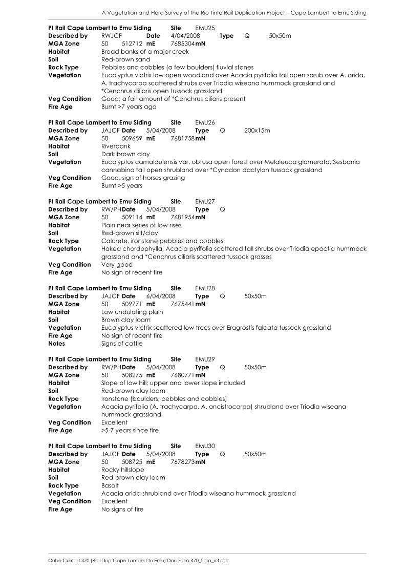
A Vegetation and Flora Survey of the Rio Tinto Rail Duplication Project – Cape Lambert to Emu Siding
Cube:Current:470 (Rail Dup Cape Lambert to Emu):Doc:Flora:470_flora_v3.doc
PI Rail Cape Lambert to Emu Siding Site EMU25 Described by RWJCF Date 4/04/2008 Type Q 50x50m MGA Zone 50 512712 mE 7685304 mN Habitat Broad banks of a major creek Soil Red-brown sand Rock Type Pebbles and cobbles (a few boulders) fluvial stones Vegetation Eucalyptus victrix low open woodland over Acacia pyrifolia tall open scrub over A. arida,
A. trachycarpa scattered shrubs over Triodia wiseana hummock grassland and *Cenchrus ciliaris open tussock grassland
Veg Condition Good; a fair amount of *Cenchrus ciliaris present Fire Age Burnt >7 years ago PI Rail Cape Lambert to Emu Siding Site EMU26 Described by JAJCF Date 5/04/2008 Type Q 200x15m MGA Zone 50 509659 mE 7681758 mN Habitat Riverbank Soil Dark brown clay Vegetation Eucalyptus camaldulensis var. obtusa open forest over Melaleuca glomerata, Sesbania
cannabina tall open shrubland over *Cynodon dactylon tussock grassland Veg Condition Good, sign of horses grazing Fire Age Burnt >5 years PI Rail Cape Lambert to Emu Siding Site EMU27 Described by RW/PH Date 5/04/2008 Type Q MGA Zone 50 509114 mE 7681954 mN Habitat Plain near series of low rises Soil Red-brown silt/clay Rock Type Calcrete, ironstone pebbles and cobbles Vegetation Hakea chordophylla, Acacia pyrifolia scattered tall shrubs over Triodia epactia hummock
grassland and *Cenchrus ciliaris scattered tussock grasses Veg Condition Very good Fire Age No sign of recent fire PI Rail Cape Lambert to Emu Siding Site EMU28 Described by JAJCF Date 6/04/2008 Type Q 50x50m MGA Zone 50 509771 mE 7675441 mN Habitat Low undulating plain Soil Brown clay loam Vegetation Eucalyptus victrix scattered low trees over Eragrostis falcata tussock grassland Fire Age No sign of recent fire Notes Signs of cattle PI Rail Cape Lambert to Emu Siding Site EMU29 Described by RW/PH Date 5/04/2008 Type Q 50x50m MGA Zone 50 508275 mE 7680771 mN Habitat Slope of low hill; upper and lower slope included Soil Red-brown clay loam Rock Type Ironstone (boulders, pebbles and cobbles) Vegetation Acacia pyrifolia (A. trachycarpa, A. ancistrocarpa) shrubland over Triodia wiseana
hummock grassland Veg Condition Excellent Fire Age >5-7 years since fire PI Rail Cape Lambert to Emu Siding Site EMU30 Described by JAJCF Date 5/04/2008 Type Q 50x50m MGA Zone 50 508725 mE 7678273 mN Habitat Rocky hillslope Soil Red-brown clay loam Rock Type Basalt Vegetation Acacia arida shrubland over Triodia wiseana hummock grassland Veg Condition Excellent Fire Age No signs of fire

A Vegetation and Flora Survey of the Rio Tinto Rail Duplication Project – Cape Lambert to Emu Siding
Cube:Current:470 (Rail Dup Cape Lambert to Emu):Doc:Flora:470_flora_v3.doc
PI Rail Cape Lambert to Emu Siding Site EMU31 Described by RW/PH Date 5/04/2008 Type Q 50x50m MGA Zone 50 509701 mE 7676902 mN Habitat High plain adjacent to lake Soil Light grey sandy clay Rock Type Calcrete and ironstone Vegetation Trianthema triquetra, Halosarcia indica subsp. leiostachya low open shrubland over
*Cynodon dactylon open tussock grassland. Veg Condition Very Good Fire Age No signs of fire PI Rail Cape Lambert to Emu Siding Site EMU32 Described by JAJCF Date 5/04/2008 Type Q 100x25m MGA Zone 50 509527 mE 7675320 mN Habitat Raised area in a ?saline floodplain Soil Orange-brown clay-loam Vegetation Eucalyptus victrix low open woodland over Halosarcia indica subsp. leiostachya,
Trianthema triquetra low open heath Veg Condition Good Fire Age No sign of recent fire PI Rail Cape Lambert to Emu Siding Site EMU33 Described by RW/PH Date 6/04/2008 Type Q 50x50m MGA Zone 50 509845 mE 7675212 mN Habitat Plain adjacent to lake Soil Brown clay loam Vegetation Eucalyptus camaldulensis low open woodland over Sesbania cannabina tall shrubland
over Stemodia grossa, Streptoglossa liatroides scattered low shrubs over *Cynodon dactylon (Eragrostis falcata, Sporobolus mitchellii) closed tussock grassland
Veg Condition Good Fire Age No sign of fire PI Rail Cape Lambert to Emu Siding Site EMU34 Described by JAJCF Date 6/04/2008 Type Q 50x50m MGA Zone 50 509969 mE 7673071 mN Habitat Low rise within broad stony plain Soil Red-brown loam Vegetation Triodia wiseana hummock grassland Veg Condition Excellent Fire Age No signs of recent fire PI Rail Cape Lambert to Emu Siding Site EMU35 Described by RW/PH Date 6/04/2008 Type Q 50x50m MGA Zone 50 509642 mE 7673911 mN Habitat Broad plain Soil Red-brown clay Rock Type Ironstone pebbles and cobbles Vegetation Acacia xiphophylla tall open shrubland over Aristida latifolia scattered tussock grasses
and Triodia wiseana scattered hummock grasses Veg Condition Excellent Fire Age >10 years PI Rail Cape Lambert to Emu Siding Site EMU36 Described by JAJCF Date 6/04/2008 Type Q 50x50m MGA Zone 50 510924 mE 7668764 mN Habitat Broad rise on a plain Soil Red-brown clay loam, cracking in places Rock Type Basalt stones and pebbles Vegetation Neptunia dimorphantha, Desmodium muelleri, Euphorbia coghlanii, Heliotropium
conocarpum, Dichanthium sericeum subsp humilius closed herbland/bunch grassland Veg Condition Excellent Fire Age No evidence of recent fire

A Vegetation and Flora Survey of the Rio Tinto Rail Duplication Project – Cape Lambert to Emu Siding
Cube:Current:470 (Rail Dup Cape Lambert to Emu):Doc:Flora:470_flora_v3.doc
PI Rail Cape Lambert to Emu Siding Site EMU37 Described by RW/PH Date 6/04/2008 Type Q 50x50m MGA Zone 50 510666 mE 7670043 mN Habitat Plain near a series of medium rises Soil Red-brown clay Rock Type Colluvial ironstone pebbles and cobbles Vegetation Cassia oligophylla scattered low shrubs over Triodia wiseana hummock grassland with
Eriachne flaccida scattered tussock grasses and mixed species herbland Veg Condition Excellent Fire Age No sign of recent fire PI Rail Cape Lambert to Emu Siding Site EMU38 Described by JA/PH Date 7/04/2008 Type Q 50x50m MGA Zone 50 510322 mE 7664651 mN Habitat Broad plain Soil Red-brown clay loam Rock Type Ironstone Vegetation Acacia inaequilatera, A. bivenosa scattered tall shrubs over Triodia wiseana hummock
grassland Veg Condition Excellent Fire Age 7-10 years PI Rail Cape Lambert to Emu Siding Site EMU39 Described by RWJCF Date 7/04/2008 Type Q 50x50m MGA Zone 50 510688 mE 7665591 mN Habitat Flat plain near base of medium rise Soil Red brown clay loam Rock Type Ironstone pebbles and cobbles Vegetation Triodia angusta hummock grassland Veg Condition Very good; some *Cenchrus ciliaris and *C. setiger Fire Age >5 years PI Rail Cape Lambert to Emu Siding Site EMU40 Described by JA/PH Date 7/04/2008 Type Q 50x50m MGA Zone 50 510049 mE 7664069 mN Habitat Low rise on a plain at the base of some medium hills Soil Red-brown clay loam Rock Type Oxidised basalt Vegetation Triodia wiseana open hummock grassland over *Cenchrus ciliaris scattered tussock
grasses over Vigna lanceolata, Streptoglossa bubakii open herbland Veg Condition Very Good (one section of *Cenchrus ciliaris) Fire Age No sign of recent fire Notes Site has patches of drier areas containing Triodia, and wetter clay crabholes supporting
Vigna PI Rail Cape Lambert to Emu Siding Site EMU41 Described by RWJCF Date 7/04/2008 Type Q 50x50m MGA Zone 50 508653 mE 7661824 mN Habitat Floodplain (creekbed) Soil Grey-brown sand - river Rock Type Riverstone alluvial pebbles, cobbles and bounders Vegetation Eucalyptus victrix woodland over Melaleuca glomerata, Acacia ampliceps, A. coriacea
subsp. pendens low open woodland over *Cenchrus ciliaris very open tussock grassland over a mixed species herbland.
Veg Condition Very good - some *Cenchrus ciliaris Fire Age No sign of fire Notes Melaleuca argentea (5-12m) noted outside the quadrat PI Rail Cape Lambert to Emu Siding Site EMU42 Described by Date 8/04/2008 Type Q 50x50m MGA Zone 50 510104 mE 7664942 mN Habitat Foothill of rocky medium hills Soil Red-brown Sandy Clay Rock Type Ironstone pebbles cobbles Vegetation Corymbia hamersleyana, Acacia inaequilatera low open woodland over Cassia
pruinosa, C. glutinosa scattered tall shrubs over Triodia wiseana hummock grassland.

A Vegetation and Flora Survey of the Rio Tinto Rail Duplication Project – Cape Lambert to Emu Siding
Cube:Current:470 (Rail Dup Cape Lambert to Emu):Doc:Flora:470_flora_v3.doc
Veg Condition Excellent Fire Age >2 years PI Rail Cape Lambert to Emu Siding Site EMU43 Described by RWJCF Date 7/04/2008 Type Q 25x100m MGA Zone 50 508098 mE 7660538 mN Habitat Creek banks and adjacent flood area Soil Grey-brown river sand Rock Type Fluvial riverstone, pebbles cobbles ad boulders Vegetation Eucalyptus victrix scattered trees over Melaleuca glomerata (Acacia coriacea subsp
pendens, A. ampliceps) low woodland over *Cenchrus ciliaris scattered tussock grasses Veg Condition Very good Fire Age No sign of fire PI Rail Cape Lambert to Emu Siding Site EMU47 Described by PH/J Date 8/04/2008 Type Q MGA Zone 50 506758 mE 7660090 mN Habitat Broad plain Soil Red-brown clay-loam with ironstone and chert pebbles on surface Vegetation Corymbia hamersleyana, Hakea chordophylla scattered low trees over Acacia bivenosa
tall open shrubland over Triodia wiseana hummock grassland Veg Condition Excellent Fire Age No sign of recent fire PI Rail Cape Lambert to Emu Siding Site EMU-JAA Described by JA/RW Date 8/04/2008 Type R MGA Zone 50 510140 mE 7664850 mN Habitat Rocky river bed Soil Orange-brown loam Vegetation Eucalyptus victrix low woodland over Acacia trachycarpa, A. pyrifolia tall shrubland over
Indigofera monophylla, Sesbania cannabina open shrubland over Triodia wiseana open hummock grassland over Themeda triandra, *Cenchrus ciliaris tussock grassland
Fire Age No sign of recent fire PI Rail Cape Lambert to Emu Siding Site EMU-MA Described by MM Date 2/04/2008 Type R MGA Zone 50 510601 mE 7703226 mN Habitat Upper slopes of rocky hill Rock Type ?Basalt Vegetation Terminalia canescens low open woodland over Triodia wiseana very open hummock
grassland with *Cenchrus ciliaris tussock grassland Veg Condition Good to Poor; considerable weed invasion PI Rail Cape Lambert to Emu Siding Site EMU-MB Described by JA/MM Date 3/04/2008 Type R 120x10m MGA Zone 50 510263 mE 7700947 mN Habitat Creekline Soil Red clay-loam Vegetation Eucalyptus victrix, Corymbia hamersleyana low open woodland over Acacia
trachycarpa, A. ancistrocarpa, A. pyrifolia tall open scrub over Corchorus parviflorus, Hibiscus sturtii var. platychlamys, Indigofera monophylla (Burrup form) low shrubland over *Cenchrus ciliaris closed tussock grassland
Veg Condition Poor to Very Poor; invaded by Cenchrus and considerable earthworks (rock armouring) Fire Age No evidence of recent fire PI Rail Cape Lambert to Emu Siding Site EMU-MC Described by MM Date 3/04/2008 Type R MGA Zone 50 510194 mE 7695796 mN Habitat Rockpile on east side of creekline Soil Brown clay-loam in pockets amongst rocks and boulders Rock Type Basalt Vegetation Acacia coriacea subsp. coriacea, Dichrostachys spicata, Ehretia saligna tall shrubland
over *Cenchrus ciliaris very open tussock grassland Veg Condition Good; fair amount of *Cenchrus

A Vegetation and Flora Survey of the Rio Tinto Rail Duplication Project – Cape Lambert to Emu Siding
Cube:Current:470 (Rail Dup Cape Lambert to Emu):Doc:Flora:470_flora_v3.doc
PI Rail Cape Lambert to Emu Siding Site EMU-MD Described by MM Date 3/04/2008 Type R MGA Zone 50 510234 mE 7695557 mN Habitat Upper slopes and crest of rocky hill (areas around basalt rockpiles) Soil Brown fine sandy loam Rock Type Basalt Vegetation Acacia pyrifolia scattered tall shrubs over A. arida open shrubland over Triodia epactia
(T. wiseana) hummock grassland Veg Condition Excellent Notes Naturally species poor. PI Rail Cape Lambert to Emu Siding Site EMU-ME Described by MM Date 4/04/2008 Type R MGA Zone 50 512200 mE 7686786 mN Habitat Upper slopes of rocky hill Soil Orange-brown clay-loam Rock Type ?Granite; grey fine-grained Vegetation Terminalia canescens low open woodland over Cassia oligophylla shrubland over Triodia
wiseana open hummock grassland Veg Condition Very Good; scattered weeds PI Rail Cape Lambert to Emu Siding Site EMU-MF Described by MM Date 4/04/2008 Type R MGA Zone 50 510924 mE 7684080 mN Habitat Rocky creekline Vegetation Terminalia canescens low open forest over Acacia arida open shrubland over Triodia
wiseana open hummock grassland PI Rail Cape Lambert to Emu Siding Site EMU-MG Described by MM Date 5/04/2008 Type R MGA Zone 50 508678 mE 7678073 mN Habitat Basalt rockpile Soil Orange-brown loam in pockets amongst rocks Vegetation Terminalia canescens low woodland over Ptilotus obovatus low open shrubland over
Triodia wiseana open hummock grassland Veg Condition Very Good; only scattered weeds PI Rail Cape Lambert to Emu Siding Site EMU-MH Described by MM Date 5/04/2008 Type MGA Zone 50 509592 mE 7676053 mN Habitat Floodplain Soil Orange-brown loam to clay loam Vegetation Eucalyptus camaldulensis var. obtusa, E. victrix low woodland over Halosarcia indica
subsp. leiostachya low open heath Veg Condition Very Good; scattered weeds PI Rail Cape Lambert to Emu Siding Site EMU-MI Described by MM Date 6/04/2008 Type R MGA Zone 50 510775 mE 7669278 mN Habitat Creekline with gravelly/cobbly bed Soil Tan coarse sand Vegetation Eucalyptus victrix low open woodland over Acacia arida tall open shrubland over Triodia
epactia very open hummock grassland Veg Condition Very Good; occasional dense patch of *Cenchrus Notes Incomplete releve. Scoured out from recent floods; vegetation to west has considerable
Acacia trachycarpa. PI Rail Cape Lambert to Emu Siding Site EMU-MJ Described by MM Date 7/04/2008 Type R MGA Zone 50 510831 mE 7665907 mN Habitat Slope of rocky ridge Soil Orange-brown clay loam with small patches of proper clay Rock Type Basalt?/dolerite? Vegetation Acacia inaequilatera scattered tall shrubs over Triodia wiseana hummock grassland Notes Species on list from Rhynchosia minima onwards were only present on small patches of
more clayey soil.

A Vegetation and Flora Survey of the Rio Tinto Rail Duplication Project – Cape Lambert to Emu Siding
Cube:Current:470 (Rail Dup Cape Lambert to Emu):Doc:Flora:470_flora_v3.doc
PI Rail Cape Lambert to Emu Siding Site EMU-MK Described by MM Date 6/04/2008 Type R MGA Zone 50 509772 mE 7676606 mN Habitat Rockpile Soil Virtually no soil; small pockets of brown loam Rock Type Basalt Vegetation Ehretia saligna var. saligna tall open shrubland over Triodia wiseana very open hummock
grassland Veg Condition Very Good; only occasional weeds Notes Very little vegetation on this rockpile ridge Cape Lambert Port B Expansion Site CLE09 Described by B/H/J Date 6/10/2007 Type Q 50x50 MGA Zone 50 513929 mE 7715910 mN Habitat Coastal flood plain. Soil Dark brown clay loam. Vegetation Acacia ampliceps tall shrubland over Sporobolus virginicus closed tussock grassland Veg Condition Very good. Fire Age unburnt Cape Lambert Port B Expansion Site CLE10 Described by RO/HM Date 6/10/2007 Type Q 50x50 MGA Zone 50 513913 mE 7716049 mN Habitat Low lying, saline drainage area just above sea level. Flat area surrounded by gentle
slopes. Vegetation Sesbania canabina tall open herbland over Sporobolous virginicus closed tussock
grassland Veg Condition Excellent Fire Age Unburnt Cape Lambert Port B Expansion Site CLE11 Described by JCF/H Date 7/10/2007 Type Q 50x50 MGA Zone 50 514083 mE 7716481 mN Habitat Rocky hillcrest. Soil Red brown clay. Rock Type Ironstone. Vegetation Triodia epactia, T. wiseana hummock grassland with Themeda triandra very open tussock
grassland Veg Condition Good Fire Age > 5 years since fire Cape Lambert Port B Expansion Site CLE15 Described by JCF/H Date 8/10/2007 Type Q 50x50 MGA Zone 50 514099 mE 7716374 mN Habitat Rocky hillslope. Soil Red brown sandy clay. Rock Type Ironstone. Vegetation Triodia epactia, T. wiseana hummock grassland with *Cenchrus ciliaris very open tussock
grassland Veg Condition Very good. Fire Age >5 years since fire Cape Lambert Port B Expansion Site CLE16 Described by B/RO Date 8/10/2007 Type Q 50x50 MGA Zone 50 514204 mE 7716385 mN Habitat Flat, piedmont zone at base of hill, between rail line and hillslope. Soil Red, alluvial, fine grained clayey loam. Rock Type Ironstone. Vegetation Acacia stellaticeps open heath over Triodia epactia, T. schinzii open hummock grassland Veg Condition Very Good Fire Age > 5-7 years since fire. Dampier Power Station Study Site DPS05 Described by RO Date 29/03/2008 Type Q 50x50 MGA Zone 50 513412 mE 7714788 mN Habitat Sporobolus grass plain surrounding low rocky hills between coastal dune systems and
rocky Soil Red brown clay with loamy clay soil surface layers to a depth of 5cm. Rock Type Rare, scattered pieces of ironstone pebbles on soil surface.

A Vegetation and Flora Survey of the Rio Tinto Rail Duplication Project – Cape Lambert to Emu Siding
Cube:Current:470 (Rail Dup Cape Lambert to Emu):Doc:Flora:470_flora_v3.doc
Vegetation Sporobolus virginicus tussock grassland Veg Condition Excellent Fire Age < 2 years since fire. Dampier Power Station Transmission Line Study Site MWS02 Described by RO/HM Date 29/05/2008 Type Q 50x50m MGA Zone 50 510526 mE 7712454 mN Habitat Plain - Alluvial clay plain between rocky hills, floodplain and drainage valley. Soil Cracking clay, crabhole in patches Rock Type Ironstone with small amounts of quartz present Vegetation Eriachne benthamii very open tussock grassland Veg Condition Excellent Fire Age Unburnt 7-8 years

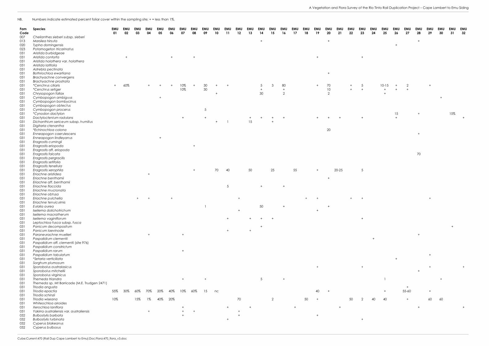
A Vegetation and Flora Survey of the Rio Tinto Rail Duplication Project – Cape Lambert to Emu Siding
Cube:Current:470 (Rail Dup Cape Lambert to Emu):Doc:Flora:470_flora_v3.doc
NB. Numbers indicate estimated percent foliar cover within the sampling site; + = less than 1%.
Fam Code
Species EMU 01
EMU 02
EMU 03
EMU 04
EMU 05
EMU 06
EMU 07
EMU 08
EMU 09
EMU 10
EMU 11
EMU 12
EMU 13
EMU 14
EMU 15
EMU 16
EMU 17
EMU 18
EMU 19
EMU 20
EMU 21
EMU 22
EMU 23
EMU 24
EMU 25
EMU 26
EMU 27
EMU 28
EMU 29
EMU 30
EMU 31
EMU 32
007 Cheilanthes sieberi subsp. sieberi 013 Marsilea hirsuta + + + 020 Typha domingensis + 023 Potamogeton tricarinatus 031 Aristida burbidgeae 031 Aristida contorta + + + + + 031 Aristida holathera var. holathera 031 Aristida latifolia 031 Astrebla pectinata 031 Bothriochloa ewartiana + 031 Brachyachne convergens 031 Brachyachne prostrata 031 *Cenchrus ciliaris + 60% + + + 10% + 30 + + 5 3 80 + 70 + 5 10-15 + 2 + 031 *Cenchrus setiger 10% 30 + + 10 + + + + + 031 Chrysopogon fallax + 30 2 2 + 031 Cymbopogon ambiguus + + 031 Cymbopogon bombycinus 031 Cymbopogon obtectus 031 Cymbopogon procerus 5 031 *Cynodon dactylon 15 + 15% 031 Dactyloctenium radulans + + + + + + + + + + + + 031 Dichanthium sericeum subsp. humilius + 1 15 + 031 Digitaria ctenantha 031 *Echinochloa colona 20 031 Enneapogon caerulescens + 031 Enneapogon lindleyanus + 031 Eragrostis cumingii 031 Eragrostis eriopoda + 031 Eragrostis aff. eriopoda 031 Eragrostis falcata 70 031 Eragrostis pergracilis 031 Eragrostis setifolia 031 Eragrostis tenellula 031 Eragrostis xerophila + 70 40 50 25 55 + 20-25 5 031 Eriachne aristidea + 031 Eriachne benthamii + 031 Eriachne aff. benthamii 031 Eriachne flaccida 5 + + 031 Eriachne mucronata 031 Eriachne obtusa 031 Eriachne pulchella + + + + + + + + + 031 Eriachne tenuiculmis 031 Eulalia aurea 1 50 + + 031 Iseilema dolichotrichum + + 031 Iseilema macratherum 031 Iseilema vaginiflorum + + + + + 031 Leptochloa fusca subsp. fusca 031 Panicum decompositum + + 031 Panicum laevinode + + 031 Paraneurachne muelleri + + + 031 Paspalidium clementii + 031 Paspalidium aff. clementii (site 976) 031 Paspalidium constrictum 031 Paspalidium rarum + 031 Paspalidium tabulatum + 031 *Setaria verticillata + 031 Sorghum plumosum 031 Sporobolus australasicus + + + + 031 Sporobolus mitchellii + 031 Sporobolus virginicus 031 Themeda triandra + + 5 + 1 + 031 Themeda sp. Mt Barricade (M.E. Trudgen 2471) 031 Triodia angusta + 031 Triodia epactia 55% 30% 60% 70% 20% 40% 10% 60% 15 nc 40 + + 55-60 + 031 Triodia schinzii 031 Triodia wiseana 10% 15% 1% 40% 20% 70 2 50 + 50 2 40 40 + 60 60 031 Whiteochloa airoides 031 Xerochloa laniflora + + + + + + + 031 Yakirra australiensis var. australiensis + + + + 032 Bulbostylis barbata + + + 032 Bulbostylis turbinata + + 032 Cyperus blakeanus 032 Cyperus bulbosus

A Vegetation and Flora Survey of the Rio Tinto Rail Duplication Project – Cape Lambert to Emu Siding
Cube:Current:470 (Rail Dup Cape Lambert to Emu):Doc:Flora:470_flora_v3.doc
Fam Code
Species EMU 01
EMU 02
EMU 03
EMU 04
EMU 05
EMU 06
EMU 07
EMU 08
EMU 09
EMU 10
EMU 11
EMU 12
EMU 13
EMU 14
EMU 15
EMU 16
EMU 17
EMU 18
EMU 19
EMU 20
EMU 21
EMU 22
EMU 23
EMU 24
EMU 25
EMU 26
EMU 27
EMU 28
EMU 29
EMU 30
EMU 31
EMU 32
032 Cyperus cunninghamii subsp. cunninghamii 032 Cyperus iria 032 Cyperus squarrosus 032 Cyperus vaginatus + 032 Fimbristylis dichotoma + + + + + + + + 032 Fimbristylis microcarya + + 032 Fimbristylis simulans 032 Schoenoplectus subulatus 047 Commelina ensifolia 087 Ficus aculeata var. indecora 087 Ficus brachypoda 090 Grevillea pyramidalis subsp. leucadendron 090 Grevillea wickhamii (sterile material) 090 Grevillea wickhamii subsp. hispidula 090 Hakea chordophylla 090 Hakea lorea subsp. lorea + + + + + 1 + 092 Santalum lanceolatum 105 Atriplex bunburyana 105 Atriplex codonocarpa + + 105 Dysphania plantaginella + + 105 Dysphania rhadinostachya 105 Enchylaena tomentosa var. tomentosa 105 Halosarcia auriculata 105 Halosarcia halocnemoides subsp. tenuis 105 Halosarcia indica subsp. leiostachya + 15% 50 105 Maireana georgei 105 Maireana villosa + + 105 Neobassia astrocarpa 105 Rhagodia eremaea 105 Salsola tragus + + + + + + + + + + + + 105 Sclerolaena bicornis 105 Sclerolaena hostilis 106 *Aerva javanica + + + + + 106 Alternanthera nana + + 106 Alternanthera nodiflora + + + + 106 Amaranthus undulatus + + 106 Amaranthus sp. 106 Gomphrena affinis subsp. pilbarensis + + + 106 Gomphrena cunninghamii + + + + + 106 Hemichroa diandra 106 Ptilotus astrolasius var. astrolasius + 106 Ptilotus auriculifolius 106 Ptilotus axillaris 106 Ptilotus calostachyus var. calostachyus + + + + + + 106 Ptilotus clementii 106 Ptilotus exaltatus var. exaltatus + + + + + + + + + + + + + + 106 Ptilotus fusiformis var. fusiformis 106 Ptilotus gomphrenoides var. gomphrenoides + 106 Ptilotus helipteroides var. helipteroides + + + + 106 Ptilotus incanus 106 Ptilotus macrocephalus 106 Ptilotus murrayi + + 106 Ptilotus obovatus + 106 Ptilotus polystachyus var. arthrotrichus 106 Ptilotus polystachyus var. polystachyus 107 Boerhavia burbidgeana 107 Boerhavia coccinea 107 Boerhavia gardneri + + + + 107 Boerhavia paludosa nc + + 107 Boerhavia schomburgkiana 108 Codonocarpus cotinifolius 110 Trianthema triquetra 25% 110 Trianthema aff. triquetra (M3.35) + 110 Trianthema turgidifolia 110 Trianthema sp. 110 Zaleya galericulata 110A Glinus lotoides 110A Mollugo molluginea 111 Calandrinia quadrivalvis 111 Portulaca conspicua + 111 *Portulaca oleracea + + + + + + + 113 Polycarpaea corymbosa var. corymbosa + 113 Polycarpaea holtzei + 113 Polycarpaea longiflora + + + + 122 Tinospora smilacina +
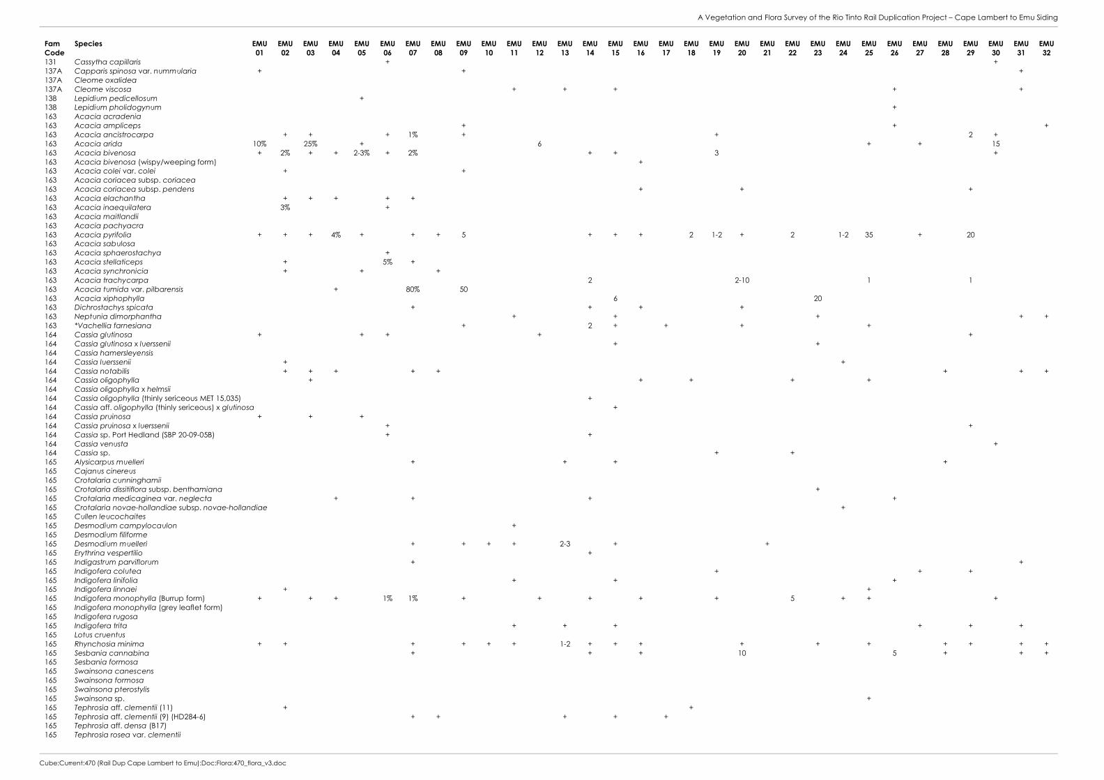
A Vegetation and Flora Survey of the Rio Tinto Rail Duplication Project – Cape Lambert to Emu Siding
Cube:Current:470 (Rail Dup Cape Lambert to Emu):Doc:Flora:470_flora_v3.doc
Fam Code
Species EMU 01
EMU 02
EMU 03
EMU 04
EMU 05
EMU 06
EMU 07
EMU 08
EMU 09
EMU 10
EMU 11
EMU 12
EMU 13
EMU 14
EMU 15
EMU 16
EMU 17
EMU 18
EMU 19
EMU 20
EMU 21
EMU 22
EMU 23
EMU 24
EMU 25
EMU 26
EMU 27
EMU 28
EMU 29
EMU 30
EMU 31
EMU 32
131 Cassytha capillaris + + 137A Capparis spinosa var. nummularia + + + 137A Cleome oxalidea 137A Cleome viscosa + + + + + 138 Lepidium pedicellosum + 138 Lepidium pholidogynum + 163 Acacia acradenia 163 Acacia ampliceps + + + 163 Acacia ancistrocarpa + + + 1% + + 2 + 163 Acacia arida 10% 25% + 6 + + 15 163 Acacia bivenosa + 2% + + 2-3% + 2% + + 3 + 163 Acacia bivenosa (wispy/weeping form) + 163 Acacia colei var. colei + + 163 Acacia coriacea subsp. coriacea 163 Acacia coriacea subsp. pendens + + + 163 Acacia elachantha + + + + + 163 Acacia inaequilatera 3% + 163 Acacia maitlandii 163 Acacia pachyacra 163 Acacia pyrifolia + + + 4% + + + 5 + + + 2 1-2 + 2 1-2 35 + 20 163 Acacia sabulosa 163 Acacia sphaerostachya + 163 Acacia stellaticeps + 5% + 163 Acacia synchronicia + + + 163 Acacia trachycarpa 2 2-10 1 1 163 Acacia tumida var. pilbarensis + 80% 50 163 Acacia xiphophylla 6 20 163 Dichrostachys spicata + + + + 163 Neptunia dimorphantha + + + + + 163 *Vachellia farnesiana + 2 + + + + 164 Cassia glutinosa + + + + + 164 Cassia glutinosa x luerssenii + + 164 Cassia hamersleyensis 164 Cassia luerssenii + + 164 Cassia notabilis + + + + + + + + 164 Cassia oligophylla + + + + + 164 Cassia oligophylla x helmsii 164 Cassia oligophylla (thinly sericeous MET 15,035) + 164 Cassia aff. oligophylla (thinly sericeous) x glutinosa + 164 Cassia pruinosa + + + 164 Cassia pruinosa x luerssenii + + 164 Cassia sp. Port Hedland (SBP 20-09-05B) + + 164 Cassia venusta + 164 Cassia sp. + + 165 Alysicarpus muelleri + + + + 165 Cajanus cinereus 165 Crotalaria cunninghamii 165 Crotalaria dissitiflora subsp. benthamiana + 165 Crotalaria medicaginea var. neglecta + + + + 165 Crotalaria novae-hollandiae subsp. novae-hollandiae + 165 Cullen leucochaites 165 Desmodium campylocaulon + 165 Desmodium filiforme 165 Desmodium muelleri + + + + 2-3 + + 165 Erythrina vespertilio + 165 Indigastrum parviflorum + + 165 Indigofera colutea + + + 165 Indigofera linifolia + + + 165 Indigofera linnaei + + 165 Indigofera monophylla (Burrup form) + + + 1% 1% + + + + + 5 + + + 165 Indigofera monophylla (grey leaflet form) 165 Indigofera rugosa 165 Indigofera trita + + + + + + 165 Lotus cruentus 165 Rhynchosia minima + + + + + + 1-2 + + + + + + + + + + 165 Sesbania cannabina + + + 10 5 + + + 165 Sesbania formosa 165 Swainsona canescens 165 Swainsona formosa 165 Swainsona pterostylis 165 Swainsona sp. + 165 Tephrosia aff. clementii (11) + + 165 Tephrosia aff. clementii (9) (HD284-6) + + + + + 165 Tephrosia aff. densa (B17) 165 Tephrosia rosea var. clementii

A Vegetation and Flora Survey of the Rio Tinto Rail Duplication Project – Cape Lambert to Emu Siding
Cube:Current:470 (Rail Dup Cape Lambert to Emu):Doc:Flora:470_flora_v3.doc
Fam Code
Species EMU 01
EMU 02
EMU 03
EMU 04
EMU 05
EMU 06
EMU 07
EMU 08
EMU 09
EMU 10
EMU 11
EMU 12
EMU 13
EMU 14
EMU 15
EMU 16
EMU 17
EMU 18
EMU 19
EMU 20
EMU 21
EMU 22
EMU 23
EMU 24
EMU 25
EMU 26
EMU 27
EMU 28
EMU 29
EMU 30
EMU 31
EMU 32
165 Tephrosia rosea var. venulosa ms 165 Tephrosia simplicifolia 165 Tephrosia supina + 165 Tephrosia aff. supina (HDC 02-01) + + + + + + + + 165 Tephrosia aff. supina (OGBP 45-006) 165 Tephrosia aff. supina 165 Tephrosia uniovulata 165 Tephrosia sp. 165 Tephrosia sp. B Kimberley Flora (C.A. Gardner 7300) + 165 Vigna lanceolata var. lanceolata + + 165 Vigna sp. Hamersley clay (AA Mitchell PRP 113) 173 Tribulus hirsutus + 173 Tribulus macrocarpus 173 Tribulus occidentalis + 173 Tribulus platypterus 173 Tribulus suberosus + + + + + 183 Polygala aff. isingii + 183 Polygala linariifolia 185 Euphorbia biconvexa + + + 185 Euphorbia boophthona 185 Euphorbia careyi + 185 Euphorbia coghlanii + + + + + + + + + + + + 185 Euphorbia aff. drummondii (MET 15,211) 1 + + 185 Euphorbia sp. (B170-4) + + + 185 Flueggea virosa subsp. melanthesoides 185 Leptopus decaisnei + + + 185 Phyllanthus erwinii + 185 Phyllanthus maderaspatensis + + + + + + + + + + + + + 185 Phyllanthus reticulatus 207 Alectryon oleifolius subsp. oleifolius 207 Dodonaea coriacea 220 Corchorus aestuans 220 Corchorus incanus subsp. incanus + + + 220 Corchorus laniflorus + + + 220 Corchorus aff. lasiocarpus (EMU 42-07) + 220 Corchorus parviflorus + + + 1 + + + 220 Corchorus aff. parviflorus + + + + + + 220 Corchorus sidoides subsp. sidoides 220 Corchorus tectus + 220 Corchorus aff. tectus (Yarrie 5-3) + 220 Corchorus tridens + + + + + + nc + + + + 220 Corchorus sp. + + 220 Triumfetta appendiculata 220 Triumfetta clementii + + + + + + + + + + + + + + + + 220 Triumfetta maconochieana 221 Abutilon dioicum 221 Abutilon fraseri + 221 Abutilon aff. lepidum (4) + + + + 221 Abutilon macrum + 221 Abutilon malvifolium + 221 Abutilon otocarpum 221 Abutilon trudgenii 221 Gossypium australe (Burrup Peninsula form) + + + 221 Gossypium australe (Whim Creek form) + 221 Gossypium robinsonii + 221 Hibiscus austrinus var. austrinus 221 Hibiscus brachysiphonius + + 221 Hibiscus aff. coatesii + + 221 Hibiscus leptocladus + 221 Hibiscus sturtii var. aff. campylochlamys (MET 15,957) + 221 Hibiscus sturtii var. aff. grandiflorus + + + 221 Hibiscus sturtii var. platychlamys + 221 Lawrencia viridigrisea 221 *Malvastrum americanum + + 10 221 Sida arsiniata 221 Sida echinocarpa + + + 221 Sida aff. fibulifera (B64-13B) 221 Sida aff. fibulifera (MET Site 1308) + + + 221 Sida aff. fibulifera (oblong; MET 15 220) 221 Sida aff. fibulifera var. L + + + 221 Sida aff. fibulifera + 221 Sida pilbarensis (ferruginous form) + + + + + 221 Sida rohlenae subsp. rohlenae + 223 Brachychiton acuminatus 223 Waltheria indica + +
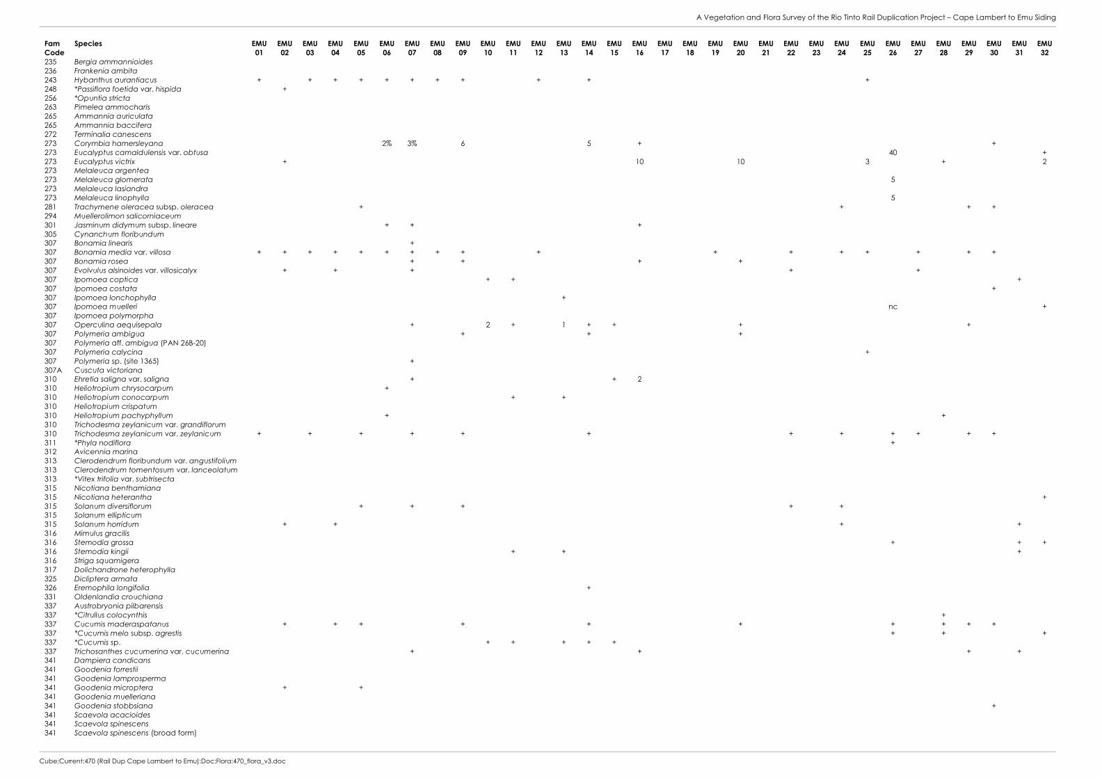
A Vegetation and Flora Survey of the Rio Tinto Rail Duplication Project – Cape Lambert to Emu Siding
Cube:Current:470 (Rail Dup Cape Lambert to Emu):Doc:Flora:470_flora_v3.doc
Fam Code
Species EMU 01
EMU 02
EMU 03
EMU 04
EMU 05
EMU 06
EMU 07
EMU 08
EMU 09
EMU 10
EMU 11
EMU 12
EMU 13
EMU 14
EMU 15
EMU 16
EMU 17
EMU 18
EMU 19
EMU 20
EMU 21
EMU 22
EMU 23
EMU 24
EMU 25
EMU 26
EMU 27
EMU 28
EMU 29
EMU 30
EMU 31
EMU 32
235 Bergia ammannioides 236 Frankenia ambita 243 Hybanthus aurantiacus + + + + + + + + + + + 248 *Passiflora foetida var. hispida + 256 *Opuntia stricta 263 Pimelea ammocharis 265 Ammannia auriculata 265 Ammannia baccifera 272 Terminalia canescens 273 Corymbia hamersleyana 2% 3% 6 5 + + 273 Eucalyptus camaldulensis var. obtusa 40 + 273 Eucalyptus victrix + 10 10 3 + 2 273 Melaleuca argentea 273 Melaleuca glomerata 5 273 Melaleuca lasiandra 273 Melaleuca linophylla 5 281 Trachymene oleracea subsp. oleracea + + + + 294 Muellerolimon salicorniaceum 301 Jasminum didymum subsp. lineare + + + 305 Cynanchum floribundum 307 Bonamia linearis + 307 Bonamia media var. villosa + + + + + + + + + + + + + + + + + 307 Bonamia rosea + + + + 307 Evolvulus alsinoides var. villosicalyx + + + + + 307 Ipomoea coptica + + + 307 Ipomoea costata + 307 Ipomoea lonchophylla + 307 Ipomoea muelleri nc + 307 Ipomoea polymorpha 307 Operculina aequisepala + 2 + 1 + + + + 307 Polymeria ambigua + + + 307 Polymeria aff. ambigua (PAN 26B-20) 307 Polymeria calycina + 307 Polymeria sp. (site 1365) + 307A Cuscuta victoriana 310 Ehretia saligna var. saligna + + 2 310 Heliotropium chrysocarpum + 310 Heliotropium conocarpum + + 310 Heliotropium crispatum 310 Heliotropium pachyphyllum + + 310 Trichodesma zeylanicum var. grandiflorum 310 Trichodesma zeylanicum var. zeylanicum + + + + + + + + + + + + 311 *Phyla nodiflora + 312 Avicennia marina 313 Clerodendrum floribundum var. angustifolium 313 Clerodendrum tomentosum var. lanceolatum 313 *Vitex trifolia var. subtrisecta 315 Nicotiana benthamiana 315 Nicotiana heterantha + 315 Solanum diversiflorum + + + + + 315 Solanum ellipticum 315 Solanum horridum + + + + 316 Mimulus gracilis 316 Stemodia grossa + + + 316 Stemodia kingii + + + 316 Striga squamigera 317 Dolichandrone heterophylla 325 Dicliptera armata 326 Eremophila longifolia + 331 Oldenlandia crouchiana 337 Austrobryonia pilbarensis 337 *Citrullus colocynthis + 337 Cucumis maderaspatanus + + + + + + + + + + 337 *Cucumis melo subsp. agrestis + + + 337 *Cucumis sp. + + + + + 337 Trichosanthes cucumerina var. cucumerina + + + + 341 Dampiera candicans 341 Goodenia forrestii 341 Goodenia lamprosperma 341 Goodenia microptera + + 341 Goodenia muelleriana 341 Goodenia stobbsiana + 341 Scaevola acacioides 341 Scaevola spinescens 341 Scaevola spinescens (broad form)
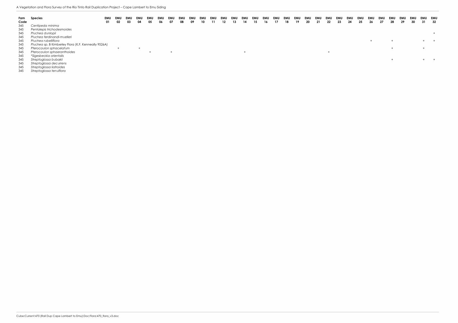
A Vegetation and Flora Survey of the Rio Tinto Rail Duplication Project – Cape Lambert to Emu Siding
Cube:Current:470 (Rail Dup Cape Lambert to Emu):Doc:Flora:470_flora_v3.doc
Fam Code
Species EMU 01
EMU 02
EMU 03
EMU 04
EMU 05
EMU 06
EMU 07
EMU 08
EMU 09
EMU 10
EMU 11
EMU 12
EMU 13
EMU 14
EMU 15
EMU 16
EMU 17
EMU 18
EMU 19
EMU 20
EMU 21
EMU 22
EMU 23
EMU 24
EMU 25
EMU 26
EMU 27
EMU 28
EMU 29
EMU 30
EMU 31
EMU 32
345 Centipeda minima 345 Pentalepis trichodesmoides 345 Pluchea dunlopii + 345 Pluchea ferdinandi-muelleri 345 Pluchea rubelliflora + + + + 345 Pluchea sp. B Kimberley Flora (K.F. Kenneally 9526A) 345 Pterocaulon sphacelatum + + + + 345 Pterocaulon sphaeranthoides + + + + 345 *Sigesbeckia orientalis 345 Streptoglossa bubakii + + + 345 Streptoglossa decurrens 345 Streptoglossa liatroides 345 Streptoglossa tenuiflora

A Vegetation and Flora Survey of the Rio Tinto Rail Duplication Project – Cape Lambert to Emu Siding
Cube:Current:470 (Rail Dup Cape Lambert to Emu):Doc:Flora:470_flora_v3.doc
Fam Code
Species EMU 33
EMU 34
EMU 35
EMU 36
EMU 37
EMU 38
EMU 39
EMU 40
EMU 41
EMU 42
EMU 43
EMU 47
EMU-JAA
EMU-MA
EMU-MB
EMU-MC
EMU-MD
EMU-ME
EMU-MF
EMU-MG
EMU-MH
EMU-MI
EMU-MJ
EMU-MK
EMU-OPP
CLE 09
CLE 10
CLE 11
CLE 15
CLE 16
DPS 05
MWS 02
007 Cheilanthes sieberi subsp. sieberi + + 013 Marsilea hirsuta + √ + 020 Typha domingensis √ 023 Potamogeton tricarinatus √ 031 Aristida burbidgeae + + + + √ 031 Aristida contorta + + + + √ + 031 Aristida holathera var. holathera √ nc 1% 031 Aristida latifolia 2% + + √ 031 Astrebla pectinata √ 031 Bothriochloa ewartiana 031 Brachyachne convergens + √ + 031 Brachyachne prostrata √ + 031 *Cenchrus ciliaris 1% 1% 6% 2% 20 40-50 80 2-5 2-3 2-3 + + + + √ 3% <1% 1% 2% 1% 031 *Cenchrus setiger + 1% + + + √ 031 Chrysopogon fallax + + √ + 031 Cymbopogon ambiguus + + + √ 031 Cymbopogon bombycinus √ 031 Cymbopogon obtectus √ 031 Cymbopogon procerus 031 *Cynodon dactylon 65% nc 1% + + √ 031 Dactyloctenium radulans + + + 1% + √ <1 031 Dichanthium sericeum subsp. humilius + 60% + + + + √ 1 031 Digitaria ctenantha √ 031 *Echinochloa colona √ 031 Enneapogon caerulescens + + + 031 Enneapogon lindleyanus 031 Eragrostis cumingii √ + 031 Eragrostis eriopoda √ nc + 031 Eragrostis aff. eriopoda 1% 031 Eragrostis falcata 1% + √ + 031 Eragrostis pergracilis <1% 031 Eragrostis setifolia √ 031 Eragrostis tenellula √ 031 Eragrostis xerophila + + √ <1% + 031 Eriachne aristidea √ 031 Eriachne benthamii 3-4 031 Eriachne aff. benthamii + √ 031 Eriachne flaccida + 1% √ 031 Eriachne mucronata + 2-3 √ 031 Eriachne obtusa + 1% <1% 031 Eriachne pulchella + + + + + + √ 031 Eriachne tenuiculmis + 30 + + 031 Eulalia aurea + + √ 031 Iseilema dolichotrichum + + √ 031 Iseilema macratherum + 031 Iseilema vaginiflorum + + + 031 Leptochloa fusca subsp. fusca + + √ 031 Panicum decompositum √ <1% + 031 Panicum laevinode √ 031 Paraneurachne muelleri 031 Paspalidium clementii √ 031 Paspalidium aff. clementii (site 976) + 031 Paspalidium constrictum + + 031 Paspalidium rarum 031 Paspalidium tabulatum + + √ 031 *Setaria verticillata 031 Sorghum plumosum √ 031 Sporobolus australasicus + + + + + + + + 031 Sporobolus mitchellii 2% √ 031 Sporobolus virginicus √ 90% 90% 65-
70
031 Themeda triandra 20 + √ 5% 1% 031 Themeda sp. Mt Barricade (M.E. Trudgen 2471) + 031 Triodia angusta 50% + + nc √ 031 Triodia epactia + + + 30 2-5 √ + 2% 30% 10-15 + 031 Triodia schinzii √ 8-10 031 Triodia wiseana 70% 1% 60% 50% 40% 30% 60 20 2-10 2-10 30 10-20 10-20 50 2-5 √ 25% 15% 031 Whiteochloa airoides + + 031 Xerochloa laniflora 1% + + √ + 031 Yakirra australiensis var. australiensis + √ + 032 Bulbostylis barbata + + + + + √ 1% + 032 Bulbostylis turbinata + + + + √ 032 Cyperus blakeanus + 032 Cyperus bulbosus 1%

A Vegetation and Flora Survey of the Rio Tinto Rail Duplication Project – Cape Lambert to Emu Siding
Cube:Current:470 (Rail Dup Cape Lambert to Emu):Doc:Flora:470_flora_v3.doc
Fam Code
Species EMU 33
EMU 34
EMU 35
EMU 36
EMU 37
EMU 38
EMU 39
EMU 40
EMU 41
EMU 42
EMU 43
EMU 47
EMU-JAA
EMU-MA
EMU-MB
EMU-MC
EMU-MD
EMU-ME
EMU-MF
EMU-MG
EMU-MH
EMU-MI
EMU-MJ
EMU-MK
EMU-OPP
CLE 09
CLE 10
CLE 11
CLE 15
CLE 16
DPS 05
MWS 02
032 Cyperus cunninghamii subsp. cunninghamii + + + 032 Cyperus iria + √ 032 Cyperus squarrosus + + √ 032 Cyperus vaginatus + + + √ 032 Fimbristylis dichotoma + √ + <1% <1 032 Fimbristylis microcarya + √ + 032 Fimbristylis simulans √ 032 Schoenoplectus subulatus √ 047 Commelina ensifolia + 087 Ficus aculeata var. indecora √ 087 Ficus brachypoda + √ 090 Grevillea pyramidalis subsp. leucadendron √ + + + 090 Grevillea wickhamii (sterile material) + √ 090 Grevillea wickhamii subsp. hispidula √ 090 Hakea chordophylla + 1 + + 090 Hakea lorea subsp. lorea + + √ + + 092 Santalum lanceolatum √ 105 Atriplex bunburyana √ 105 Atriplex codonocarpa + √ 105 Dysphania plantaginella √ 105 Dysphania rhadinostachya + + 105 Enchylaena tomentosa var. tomentosa + + √ + 105 Halosarcia auriculata √ 105 Halosarcia halocnemoides subsp. tenuis √ 105 Halosarcia indica subsp. leiostachya + 70 1-2 105 Maireana georgei + 105 Maireana villosa 105 Neobassia astrocarpa √ + 2% 105 Rhagodia eremaea + + 105 Salsola tragus + + + + + + √ + + 105 Sclerolaena bicornis + √ + 105 Sclerolaena hostilis √ 106 *Aerva javanica + + √ + nc 106 Alternanthera nana 106 Alternanthera nodiflora 106 Amaranthus undulatus + + nc + √ 106 Amaranthus sp. + 106 Gomphrena affinis subsp. pilbarensis √ 106 Gomphrena cunninghamii + + + + + + + + + √ + + 106 Hemichroa diandra √ 106 Ptilotus astrolasius var. astrolasius + + + √ 106 Ptilotus auriculifolius √ 106 Ptilotus axillaris + + √ 106 Ptilotus calostachyus var. calostachyus √ 106 Ptilotus clementii + 106 Ptilotus exaltatus var. exaltatus + + + + + + √ + <1 106 Ptilotus fusiformis var. fusiformis + √ 106 Ptilotus gomphrenoides var. gomphrenoides + 1% 3% + √ 106 Ptilotus helipteroides var. helipteroides √ 106 Ptilotus incanus √ 106 Ptilotus macrocephalus + 106 Ptilotus murrayi + 106 Ptilotus obovatus + + 2-5 √ 106 Ptilotus polystachyus var. arthrotrichus √ 106 Ptilotus polystachyus var. polystachyus √ 107 Boerhavia burbidgeana + √ 107 Boerhavia coccinea + + + + + + 107 Boerhavia gardneri √ + + 107 Boerhavia paludosa + √ 107 Boerhavia schomburgkiana √ 108 Codonocarpus cotinifolius √ 110 Trianthema triquetra + + + √ 2% + 110 Trianthema aff. triquetra (M3.35) 110 Trianthema turgidifolia √ + 110 Trianthema sp. √ 110 Zaleya galericulata √ 110A Glinus lotoides √ 110A Mollugo molluginea + √ + 111 Calandrinia quadrivalvis √ 111 Portulaca conspicua + √ + 111 *Portulaca oleracea + + + + + + √ + + 113 Polycarpaea corymbosa var. corymbosa 113 Polycarpaea holtzei + 113 Polycarpaea longiflora + + + 122 Tinospora smilacina + + + + + + √

A Vegetation and Flora Survey of the Rio Tinto Rail Duplication Project – Cape Lambert to Emu Siding
Cube:Current:470 (Rail Dup Cape Lambert to Emu):Doc:Flora:470_flora_v3.doc
Fam Code
Species EMU 33
EMU 34
EMU 35
EMU 36
EMU 37
EMU 38
EMU 39
EMU 40
EMU 41
EMU 42
EMU 43
EMU 47
EMU-JAA
EMU-MA
EMU-MB
EMU-MC
EMU-MD
EMU-ME
EMU-MF
EMU-MG
EMU-MH
EMU-MI
EMU-MJ
EMU-MK
EMU-OPP
CLE 09
CLE 10
CLE 11
CLE 15
CLE 16
DPS 05
MWS 02
131 Cassytha capillaris + + √ 137A Capparis spinosa var. nummularia + + √ 137A Cleome oxalidea √ 137A Cleome viscosa + + + + + + + + + + + + + √ + + + + 138 Lepidium pedicellosum √ 138 Lepidium pholidogynum 163 Acacia acradenia √ 163 Acacia ampliceps 2% 1% √ 15% nc 163 Acacia ancistrocarpa + 2 + √ 163 Acacia arida + 2-3 2-10 2-5 √ 163 Acacia bivenosa 1% + 5 + 1 + √ + + 163 Acacia bivenosa (wispy/weeping form) √ 163 Acacia colei var. colei √ + 163 Acacia coriacea subsp. coriacea + √ + + + 163 Acacia coriacea subsp. pendens 2% nc 5-10 + + √ 163 Acacia elachantha √ 2% 163 Acacia inaequilatera 1% 3% + √ + 163 Acacia maitlandii √ 163 Acacia pachyacra + 163 Acacia pyrifolia + + + + + 5 1-2 + + + + √ + + nc 163 Acacia sabulosa + 1-2% 163 Acacia sphaerostachya 163 Acacia stellaticeps √ 50-60 163 Acacia synchronicia √ + 163 Acacia trachycarpa + + + 30 30-40 + √ 163 Acacia tumida var. pilbarensis √ 163 Acacia xiphophylla 50% √ 163 Dichrostachys spicata + + 5 + + √ 163 Neptunia dimorphantha 1% 20% + + + + √ 4-5% + 163 *Vachellia farnesiana √ 164 Cassia glutinosa + + + + + √ + 164 Cassia glutinosa x luerssenii 164 Cassia hamersleyensis + √ 164 Cassia luerssenii + + 164 Cassia notabilis + + + + + + + √ 164 Cassia oligophylla + + 10-20 + + √ 164 Cassia oligophylla x helmsii + 164 Cassia oligophylla (thinly sericeous MET 15,035) + √ 164 Cassia aff. oligophylla (thinly sericeous) x glutinosa + 164 Cassia pruinosa + + √ 164 Cassia pruinosa x luerssenii 164 Cassia sp. Port Hedland (SBP 20-09-05B) 164 Cassia venusta √ 164 Cassia sp. 165 Alysicarpus muelleri + + + + + √ + 165 Cajanus cinereus + + √ 165 Crotalaria cunninghamii + √ 165 Crotalaria dissitiflora subsp. benthamiana + + + √ 165 Crotalaria medicaginea var. neglecta √ + 165 Crotalaria novae-hollandiae subsp. novae-hollandiae √ 165 Cullen leucochaites nc √ 165 Desmodium campylocaulon 165 Desmodium filiforme + 165 Desmodium muelleri 2% + + √ + 165 Erythrina vespertilio 165 Indigastrum parviflorum + √ 165 Indigofera colutea √ 1-2% 165 Indigofera linifolia + + √ + + + + 165 Indigofera linnaei 165 Indigofera monophylla (Burrup form) 2 + + 2-3 √ + + + 165 Indigofera monophylla (grey leaflet form) + + + √ 165 Indigofera rugosa √ 165 Indigofera trita + + + √ + + + + + 165 Lotus cruentus + 165 Rhynchosia minima 1% + + + + + + + + + + + + √ + + + + + + 1 165 Sesbania cannabina 25% + + 1% 5 + + + + √ 2% 25-30 + 165 Sesbania formosa √ 165 Swainsona canescens + 165 Swainsona formosa √ 165 Swainsona pterostylis √ 165 Swainsona sp. 165 Tephrosia aff. clementii (11) 165 Tephrosia aff. clementii (9) (HD284-6) + + + √ 165 Tephrosia aff. densa (B17) √ 165 Tephrosia rosea var. clementii + √

A Vegetation and Flora Survey of the Rio Tinto Rail Duplication Project – Cape Lambert to Emu Siding
Cube:Current:470 (Rail Dup Cape Lambert to Emu):Doc:Flora:470_flora_v3.doc
Fam Code
Species EMU 33
EMU 34
EMU 35
EMU 36
EMU 37
EMU 38
EMU 39
EMU 40
EMU 41
EMU 42
EMU 43
EMU 47
EMU-JAA
EMU-MA
EMU-MB
EMU-MC
EMU-MD
EMU-ME
EMU-MF
EMU-MG
EMU-MH
EMU-MI
EMU-MJ
EMU-MK
EMU-OPP
CLE 09
CLE 10
CLE 11
CLE 15
CLE 16
DPS 05
MWS 02
165 Tephrosia rosea var. venulosa ms √ 165 Tephrosia simplicifolia + 165 Tephrosia supina 165 Tephrosia aff. supina (HDC 02-01) + + + + √ 165 Tephrosia aff. supina (OGBP 45-006) + 165 Tephrosia aff. supina + + 165 Tephrosia uniovulata + √ 165 Tephrosia sp. √ 165 Tephrosia sp. B Kimberley Flora (C.A. Gardner 7300) √ 165 Vigna lanceolata var. lanceolata 20% + + 165 Vigna sp. Hamersley clay (AA Mitchell PRP 113) + + √ 173 Tribulus hirsutus + + √ 173 Tribulus macrocarpus √ 173 Tribulus occidentalis + √ + 173 Tribulus platypterus + √ 173 Tribulus suberosus + + √ 183 Polygala aff. isingii + + + + + 183 Polygala linariifolia √ 185 Euphorbia biconvexa + + 185 Euphorbia boophthona + 185 Euphorbia careyi + √ 1% 185 Euphorbia coghlanii + + 3% + + + √ + 185 Euphorbia aff. drummondii (MET 15,211) + + √ 185 Euphorbia sp. (B170-4) + + 185 Flueggea virosa subsp. melanthesoides + + + √ 185 Leptopus decaisnei + + + + √ 185 Phyllanthus erwinii 185 Phyllanthus maderaspatensis + + + + + + + + + + + + + + √ + 185 Phyllanthus reticulatus √ 207 Alectryon oleifolius subsp. oleifolius √ 207 Dodonaea coriacea + 220 Corchorus aestuans √ 220 Corchorus incanus subsp. incanus + + 220 Corchorus laniflorus √ 220 Corchorus aff. lasiocarpus (EMU 42-07) + 220 Corchorus parviflorus + √ 220 Corchorus aff. parviflorus + √ 220 Corchorus sidoides subsp. sidoides √ 220 Corchorus tectus + + 220 Corchorus aff. tectus (Yarrie 5-3) + 220 Corchorus tridens + + + + + + √ <1% 220 Corchorus sp. + 220 Triumfetta appendiculata √ 220 Triumfetta clementii + + + + + + + + + + √ + + 220 Triumfetta maconochieana + + + √ 221 Abutilon dioicum + + + 221 Abutilon fraseri 221 Abutilon aff. lepidum (4) + + + + + 221 Abutilon macrum 221 Abutilon malvifolium √ + 221 Abutilon otocarpum + 221 Abutilon trudgenii + √ 221 Gossypium australe (Burrup Peninsula form) nc 221 Gossypium australe (Whim Creek form) + + √ 221 Gossypium robinsonii 221 Hibiscus austrinus var. austrinus + + √ 221 Hibiscus brachysiphonius √ 221 Hibiscus aff. coatesii + 221 Hibiscus leptocladus + 221 Hibiscus sturtii var. aff. campylochlamys (MET 15,957) 221 Hibiscus sturtii var. aff. grandiflorus + + + + + + 221 Hibiscus sturtii var. platychlamys + 221 Lawrencia viridigrisea √ 221 *Malvastrum americanum √ 221 Sida arsiniata √ 221 Sida echinocarpa + √ 221 Sida aff. fibulifera (B64-13B) + 221 Sida aff. fibulifera (MET Site 1308) + + 221 Sida aff. fibulifera (oblong; MET 15 220) + 221 Sida aff. fibulifera var. L + + + + 221 Sida aff. fibulifera + 221 Sida pilbarensis (ferruginous form) + + + 221 Sida rohlenae subsp. rohlenae + 223 Brachychiton acuminatus + 223 Waltheria indica +

A Vegetation and Flora Survey of the Rio Tinto Rail Duplication Project – Cape Lambert to Emu Siding
Cube:Current:470 (Rail Dup Cape Lambert to Emu):Doc:Flora:470_flora_v3.doc
Fam Code
Species EMU 33
EMU 34
EMU 35
EMU 36
EMU 37
EMU 38
EMU 39
EMU 40
EMU 41
EMU 42
EMU 43
EMU 47
EMU-JAA
EMU-MA
EMU-MB
EMU-MC
EMU-MD
EMU-ME
EMU-MF
EMU-MG
EMU-MH
EMU-MI
EMU-MJ
EMU-MK
EMU-OPP
CLE 09
CLE 10
CLE 11
CLE 15
CLE 16
DPS 05
MWS 02
235 Bergia ammannioides √ 236 Frankenia ambita √ 243 Hybanthus aurantiacus + + + + + + + + √ + + + 248 *Passiflora foetida var. hispida + 256 *Opuntia stricta √ 263 Pimelea ammocharis √ 265 Ammannia auriculata 1 265 Ammannia baccifera 1% 272 Terminalia canescens + 2-10 2-5 50 10-20 + √ 273 Corymbia hamersleyana + 2% 1 5-10 √ 273 Eucalyptus camaldulensis var. obtusa 10-15 √ 273 Eucalyptus victrix 5% 15% 1% 25 5 10-15 10 √ 273 Melaleuca argentea √ 273 Melaleuca glomerata 4% 20% + √ 273 Melaleuca lasiandra √ 273 Melaleuca linophylla √ 281 Trachymene oleracea subsp. oleracea + + √ + 294 Muellerolimon salicorniaceum √ 301 Jasminum didymum subsp. lineare 1-2 + + √ + 305 Cynanchum floribundum √ 307 Bonamia linearis √ + 307 Bonamia media var. villosa + + + + + + + + + + + + √ + + 307 Bonamia rosea 307 Evolvulus alsinoides var. villosicalyx + + + √ + + + 307 Ipomoea coptica + + + + + + √ 1% + 307 Ipomoea costata + √ 307 Ipomoea lonchophylla + + 307 Ipomoea muelleri + + + √ 307 Ipomoea polymorpha + √ 307 Operculina aequisepala + + + √ 307 Polymeria ambigua 307 Polymeria aff. ambigua (PAN 26B-20) √ 307 Polymeria calycina + 307 Polymeria sp. (site 1365) √ 307A Cuscuta victoriana + 310 Ehretia saligna var. saligna + 2-3 + + 2-10 √ 310 Heliotropium chrysocarpum 310 Heliotropium conocarpum 5% + √ 310 Heliotropium crispatum + + √ 310 Heliotropium pachyphyllum + + √ 310 Trichodesma zeylanicum var. grandiflorum √ + + + 310 Trichodesma zeylanicum var. zeylanicum + + + + + + + √ 311 *Phyla nodiflora 312 Avicennia marina √ 313 Clerodendrum floribundum var. angustifolium + + 313 Clerodendrum tomentosum var. lanceolatum + 313 *Vitex trifolia var. subtrisecta √ 315 Nicotiana benthamiana √ 315 Nicotiana heterantha 315 Solanum diversiflorum + + + √ 315 Solanum ellipticum + 315 Solanum horridum + + + + + √ + 316 Mimulus gracilis √ 316 Stemodia grossa + + + + + √ 316 Stemodia kingii + √ 316 Striga squamigera nc 317 Dolichandrone heterophylla √ 325 Dicliptera armata + √ 326 Eremophila longifolia 331 Oldenlandia crouchiana + + + + + √ 337 Austrobryonia pilbarensis + + √ 337 *Citrullus colocynthis √ 337 Cucumis maderaspatanus + + + + + + + + √ + + 337 *Cucumis melo subsp. agrestis + + √ 337 *Cucumis sp. + + + + + + + + + √ 337 Trichosanthes cucumerina var. cucumerina + + + √ 341 Dampiera candicans + 341 Goodenia forrestii + 341 Goodenia lamprosperma + + + + √ 341 Goodenia microptera + + √ + nc + 341 Goodenia muelleriana + √ 341 Goodenia stobbsiana + 341 Scaevola acacioides + 341 Scaevola spinescens + + 341 Scaevola spinescens (broad form) √

A Vegetation and Flora Survey of the Rio Tinto Rail Duplication Project – Cape Lambert to Emu Siding
Cube:Current:470 (Rail Dup Cape Lambert to Emu):Doc:Flora:470_flora_v3.doc
Fam Code
Species EMU 33
EMU 34
EMU 35
EMU 36
EMU 37
EMU 38
EMU 39
EMU 40
EMU 41
EMU 42
EMU 43
EMU 47
EMU-JAA
EMU-MA
EMU-MB
EMU-MC
EMU-MD
EMU-ME
EMU-MF
EMU-MG
EMU-MH
EMU-MI
EMU-MJ
EMU-MK
EMU-OPP
CLE 09
CLE 10
CLE 11
CLE 15
CLE 16
DPS 05
MWS 02
345 Centipeda minima √ 345 Pentalepis trichodesmoides √ 345 Pluchea dunlopii 345 Pluchea ferdinandi-muelleri nc 1% + 345 Pluchea rubelliflora + 10 √ + + 345 Pluchea sp. B Kimberley Flora (K.F. Kenneally 9526A) + + <% 345 Pterocaulon sphacelatum + + 345 Pterocaulon sphaeranthoides + √ 345 *Sigesbeckia orientalis + 345 Streptoglossa bubakii + + 2% + 1% + √ 345 Streptoglossa decurrens + √ + 345 Streptoglossa liatroides + 345 Streptoglossa tenuiflora √

A Vegetation and Flora Survey of the Rio Tinto Rail Duplication Project – Cape Lambert to Emu Siding
Cube:Current:470 (Rail Dup Cape Lambert to Emu):Doc:Flora:470_flora_v3.doc
Appendix 5
List of Flora Species Recorded from the Study Area


A Vegetation and Flora Survey of the Rio Tinto Rail Duplication Project – Cape Lambert to Emu Siding
Cube:Current:470 (Rail Dup Cape Lambert to Emu):Doc:Flora:470_flora_v3.doc
NB. * denotes introduced species.
Comparison of Cassia vs Senna nomenclature: Cassia glutinosa = Senna glutinosa subsp. glutinosa Cassia hamersleyensis = Senna hamersleyensis Cassia helmsii = Senna artemisioides subsp. helmsii Cassia luerssenii = Senna glutinosa subsp. x luerssenii Cassia notabilis = Senna notabilis Cassia oligophylla = Senna artemisioides subsp. oligophylla Cassia pruinosa = Senna glutinosa subsp. pruinosa Cassia venusta = Senna venusta
Family Species Biota
(this study)
Biota (2008a, 2008c)
Acanthaceae (325) Dicliptera armata √ Adiantaceae (007) Cheilanthes sieberi subsp. sieberi √ Aizoaceae (110) Trianthema triquetra √ √ Trianthema aff. triquetra (M3.35) √ Trianthema turgidifolia √ √ Trianthema sp. √ Zaleya galericulata √ Amaranthaceae (106) *Aerva javanica √ √ Alternanthera nana √ Alternanthera nodiflora √ Amaranthus undulatus √ Amaranthus sp. √ Gomphrena affinis subsp. pilbarensis √ Gomphrena cunninghamii √ √ Hemichroa diandra √ Ptilotus astrolasius var. astrolasius √ Ptilotus auriculifolius √ Ptilotus axillaris √ Ptilotus calostachyus var. calostachyus √ Ptilotus clementii √ Ptilotus exaltatus var. exaltatus √ √ Ptilotus fusiformis var. fusiformis √ Ptilotus gomphrenoides var. gomphrenoides √ Ptilotus helipteroides var. helipteroides √ Ptilotus incanus √ Ptilotus macrocephalus √ Ptilotus murrayi √ √ Ptilotus obovatus √ Ptilotus polystachyus var. arthrotrichus √ Ptilotus polystachyus var. polystachyus √ Apiaceae (281) Trachymene oleracea subsp. oleracea √ √ Asclepiadaceae (305) Cynanchum floribundum √ Asteraceae (345) Centipeda minima √ Pentalepis trichodesmoides √ Pluchea dunlopii √ Pluchea ferdinandi-muelleri √ Pluchea rubelliflora √ √ Pluchea sp. B Kimberley Flora (K.F. Kenneally 9526A) √ Pterocaulon sphacelatum √ Pterocaulon sphaeranthoides √ *Sigesbeckia orientalis √ Streptoglossa bubakii √ Streptoglossa decurrens √ √ Streptoglossa liatroides √ Streptoglossa tenuiflora √ Avicenniaceae (312) Avicennia marina √ Bignoniaceae (317) Dolichandrone heterophylla √ Boraginaceae (310) Ehretia saligna var. saligna √ Heliotropium chrysocarpum √ Heliotropium conocarpum √ Heliotropium crispatum √ Heliotropium pachyphyllum √

A Vegetation and Flora Survey of the Rio Tinto Rail Duplication Project – Cape Lambert to Emu Siding
Cube:Current:470 (Rail Dup Cape Lambert to Emu):Doc:Flora:470_flora_v3.doc
Family Species Biota (this
study)
Biota (2008a, 2008c)
Trichodesma zeylanicum var. grandiflorum √ √ Trichodesma zeylanicum var. zeylanicum √ Brassicaceae (138) Lepidium pedicellosum √ Lepidium pholidogynum √ Cactaceae (256) *Opuntia stricta √ Caesalpiniaceae (164) Cassia glutinosa √ √ Cassia glutinosa x luerssenii √ Cassia hamersleyensis √ Cassia luerssenii √ Cassia notabilis √ Cassia oligophylla √ Cassia oligophylla x helmsii √ Cassia oligophylla (thinly sericeous MET 15,035) √ Cassia aff. oligophylla (thinly sericeous) x glutinosa √ √ Cassia pruinosa √ Cassia pruinosa x luerssenii √ Cassia sp. Port Hedland (SBP 20-09-05B) √ Cassia venusta √ Cassia sp. √ Capparaceae (137A) Capparis spinosa var. nummularia √ Cleome oxalidea √ Cleome viscosa √ √ Caryophyllaceae (113) Polycarpaea corymbosa var. corymbosa √ Polycarpaea holtzei √ Polycarpaea longiflora √ Chenopodiaceae (105) Atriplex bunburyana √ Atriplex codonocarpa √ Dysphania plantaginella √ Dysphania rhadinostachya √ Enchylaena tomentosa var. tomentosa √ √ Halosarcia auriculata √ Halosarcia halocnemoides subsp. tenuis √ Halosarcia indica subsp. leiostachya √ √ Maireana georgei √ Maireana villosa √ Neobassia astrocarpa √ √ Rhagodia eremaea √ √ Salsola tragus √ √ Sclerolaena bicornis √ √ Sclerolaena hostilis √ Combretaceae (272) Terminalia canescens √ Commelinaceae (047) Commelina ensifolia √ Convolvulaceae (307) Bonamia linearis √ √ Bonamia media var. villosa √ √ Bonamia rosea √ Evolvulus alsinoides var. villosicalyx √ √ Ipomoea coptica √ √ Ipomoea costata √ Ipomoea lonchophylla √ Ipomoea muelleri √ Ipomoea polymorpha √ Operculina aequisepala √ Polymeria ambigua √ Polymeria aff. ambigua (PAN 26B-20) √ Polymeria calycina √ Polymeria sp. (site 1365) √ Cucurbitaceae (337) Austrobryonia pilbarensis √ *Citrullus colocynthis √ Cucumis maderaspatanus √ √ *Cucumis melo subsp. agrestis √ *Cucumis sp. √ Trichosanthes cucumerina var. cucumerina √ Cuscutaceae (307A) Cuscuta victoriana √ Cyperaceae (032) Bulbostylis barbata √ √ Bulbostylis turbinata √

A Vegetation and Flora Survey of the Rio Tinto Rail Duplication Project – Cape Lambert to Emu Siding
Cube:Current:470 (Rail Dup Cape Lambert to Emu):Doc:Flora:470_flora_v3.doc
Family Species Biota (this
study)
Biota (2008a, 2008c)
Cyperus blakeanus √ Cyperus bulbosus √ Cyperus cunninghamii subsp. cunninghamii √ Cyperus iria √ Cyperus squarrosus √ Cyperus vaginatus √ Fimbristylis dichotoma √ √ Fimbristylis microcarya √ √ Fimbristylis simulans √ Schoenoplectus subulatus √ Elatinaceae (235) Bergia ammannioides √ Euphorbiaceae (185) Euphorbia biconvexa √ Euphorbia boophthona √ Euphorbia careyi √ √ Euphorbia coghlanii √ √ Euphorbia aff. drummondii (MET 15,211) √ Euphorbia sp. (B170-4) √ Flueggea virosa subsp. melanthesoides √ Leptopus decaisnei √ Phyllanthus erwinii √ Phyllanthus maderaspatensis √ √ Phyllanthus reticulatus √ Frankeniaceae (236) Frankenia ambita √ Goodeniaceae (341) Dampiera candicans √ Goodenia forrestii √ Goodenia lamprosperma √ Goodenia microptera √ √ Goodenia muelleriana √ Goodenia stobbsiana √ Scaevola acacioides √ Scaevola spinescens √ √ Scaevola spinescens (broad form) √ Gyrostemonaceae (108) Codonocarpus cotinifolius √ Lamiaceae (313) Clerodendrum floribundum var. angustifolium √ Clerodendrum tomentosum var. lanceolatum √ *Vitex trifolia var. subtrisecta √ Lauraceae (131) Cassytha capillaris √ Lythraceae (265) Ammannia auriculata √ Ammannia baccifera √ Malvaceae (221) Abutilon dioicum √ Abutilon fraseri √ Abutilon aff. lepidum (4) √ Abutilon macrum √ Abutilon malvifolium √ √ Abutilon otocarpum √ Abutilon trudgenii √ Gossypium australe (Burrup Peninsula form) √ √ Gossypium australe (Whim Creek form) √ Gossypium robinsonii √ Hibiscus austrinus var. austrinus √ Hibiscus brachysiphonius √ Hibiscus aff. coatesii √ Hibiscus leptocladus √ √ Hibiscus sturtii var. aff. campylochlamys (MET 15,957) √ Hibiscus sturtii var. aff. grandiflorus √ Hibiscus sturtii var. platychlamys √ Lawrencia viridigrisea √ *Malvastrum americanum √ Sida arsiniata √ Sida echinocarpa √ Sida aff. fibulifera (B64-13B) √ Sida aff. fibulifera (MET Site 1308) √ Sida aff. fibulifera (oblong; MET 15 220) √ Sida aff. fibulifera var. L √ Sida aff. fibulifera √
A Vegetation and Flora Survey of the Rio Tinto Rail Duplication Project – Cape Lambert to Emu Siding
Cube:Current:470 (Rail Dup Cape Lambert to Emu):Doc:Flora:470_flora_v3.doc
Family Species Biota (this
study)
Biota (2008a, 2008c)
Sida pilbarensis (ferruginous form) √ Sida rohlenae subsp. rohlenae √ √ Marsileaceae (013) Marsilea hirsuta √ √ Menispermaceae (122) Tinospora smilacina √ Mimosaceae (163) Acacia acradenia √ Acacia ampliceps √ √ Acacia ancistrocarpa √ Acacia arida √ Acacia bivenosa √ 2 Acacia bivenosa (wispy/weeping form) √ Acacia colei var. colei √ 1 Acacia coriacea subsp. coriacea √ 3 Acacia coriacea subsp. pendens √ Acacia elachantha √ 1 Acacia inaequilatera √ 1 Acacia maitlandii √ Acacia pachyacra √ Acacia pyrifolia √ √ Acacia sabulosa √ Acacia sphaerostachya √ Acacia stellaticeps √ √ Acacia synchronicia √ √ Acacia trachycarpa √ Acacia tumida var. pilbarensis √ Acacia xiphophylla √ Dichrostachys spicata √ Neptunia dimorphantha √ √ *Vachellia farnesiana √ Molluginaceae (110A) Glinus lotoides √ Mollugo molluginea √ √ Moraceae (087) Ficus aculeata var. indecora √ Ficus brachypoda √ Myoporaceae (326) Eremophila longifolia √ Myrtaceae (273) Corymbia hamersleyana √ Eucalyptus camaldulensis var. obtusa √ Eucalyptus victrix √ Melaleuca argentea √ Melaleuca glomerata √ Melaleuca lasiandra √ Melaleuca linophylla √ Nyctaginaceae (107) Boerhavia burbidgeana √ Boerhavia coccinea √ Boerhavia gardneri √ √ Boerhavia paludosa √ Boerhavia schomburgkiana √ Oleaceae (301) Jasminum didymum subsp. lineare √ √ Papilionaceae (165) Alysicarpus muelleri √ √ Cajanus cinereus √ Crotalaria cunninghamii √ Crotalaria dissitiflora subsp. benthamiana √ Crotalaria medicaginea var. neglecta √ √ Crotalaria novae-hollandiae subsp. novae-
hollandiae √
Cullen leucochaites √ Desmodium campylocaulon √ Desmodium filiforme √ Desmodium muelleri √ √ Erythrina vespertilio √ Indigastrum parviflorum √ Indigofera colutea √ √ Indigofera linifolia √ √ Indigofera linnaei √ Indigofera monophylla (Burrup form) √ √ Indigofera monophylla (grey leaflet form) √ Indigofera rugosa √

A Vegetation and Flora Survey of the Rio Tinto Rail Duplication Project – Cape Lambert to Emu Siding
Cube:Current:470 (Rail Dup Cape Lambert to Emu):Doc:Flora:470_flora_v3.doc
Family Species Biota (this
study)
Biota (2008a, 2008c)
Indigofera trita √ √ Lotus cruentus √ Rhynchosia minima √ √ Sesbania cannabina √ √ Sesbania formosa √ Swainsona canescens √ Swainsona formosa √ Swainsona pterostylis √ Swainsona sp. √ Tephrosia aff. clementii (9) (HD284-6) √ Tephrosia aff. clementii (11) √ Tephrosia aff. densa (B17) √ Tephrosia rosea var. clementii √ Tephrosia rosea var. venulosa ms √ Tephrosia simplicifolia √ Tephrosia supina √ Tephrosia aff. supina (HDC 02-01) √ Tephrosia aff. supina (OGBP 45-006) √ Tephrosia aff. supina √ Tephrosia uniovulata √ Tephrosia sp. B Kimberley Flora (C.A. Gardner 7300) √ Tephrosia sp. √ Vigna lanceolata var. lanceolata √ √ Vigna sp. Hamersley clay (AA Mitchell PRP 113) √ Passifloraceae (248) *Passiflora foetida var. hispida √ Plumbaginaceae (294) Muellerolimon salicorniaceum √ Poaceae (031) Aristida burbidgeae √ Aristida contorta √ √ Aristida holathera var. holathera √ √ Aristida latifolia √ Astrebla pectinata √ Bothriochloa ewartiana √ Brachyachne convergens √ √ Brachyachne prostrata √ √ *Cenchrus ciliaris √ √ *Cenchrus setiger √ Chrysopogon fallax √ √ Cymbopogon ambiguus √ Cymbopogon bombycinus √ Cymbopogon obtectus √ Cymbopogon procerus √ *Cynodon dactylon √ Dactyloctenium radulans √ √ Dichanthium sericeum subsp. humilius √ √ Digitaria ctenantha √ *Echinochloa colona √ Enneapogon caerulescens √ √ Enneapogon lindleyanus √ Eragrostis cumingii √ √ Eragrostis eriopoda √ √ Eragrostis aff. eriopoda √ Eragrostis falcata √ √ Eragrostis pergracilis √ Eragrostis setifolia √ Eragrostis tenellula √ Eragrostis xerophila √ √ Eriachne aristidea √ Eriachne benthamii √ √ Eriachne aff. benthamii √ Eriachne flaccida √ Eriachne mucronata √ Eriachne obtusa √ Eriachne pulchella √ Eriachne tenuiculmis √ Eulalia aurea √
A Vegetation and Flora Survey of the Rio Tinto Rail Duplication Project – Cape Lambert to Emu Siding
Cube:Current:470 (Rail Dup Cape Lambert to Emu):Doc:Flora:470_flora_v3.doc
Family Species Biota (this
study)
Biota (2008a, 2008c)
Iseilema dolichotrichum √ Iseilema macratherum √ Iseilema vaginiflorum √ Leptochloa fusca subsp. fusca √ Panicum decompositum √ √ Panicum laevinode √ Paraneurachne muelleri √ Paspalidium clementii √ Paspalidium aff. clementii (site 976) √ Paspalidium constrictum √ Paspalidium rarum √ Paspalidium tabulatum √ *Setaria verticillata √ Sorghum plumosum √ Sporobolus australasicus √ √ Sporobolus mitchellii √ Sporobolus virginicus √ √ Themeda triandra √ √ Themeda sp. Mt Barricade (M.E. Trudgen 2471) √ Triodia angusta √ Triodia epactia √ √ Triodia schinzii √ √ Triodia wiseana √ √ Whiteochloa airoides √ Xerochloa laniflora √ √ Yakirra australiensis var. australiensis √ √ Polygalaceae (183) Polygala aff. isingii √ Polygala linariifolia √ Portulacaceae (111) Calandrinia quadrivalvis √ Portulaca conspicua √ √ *Portulaca oleracea √ √ Potamogetonaceae (023) Potamogeton tricarinatus √ Proteaceae (090) Grevillea pyramidalis subsp. leucadendron √ √ Grevillea wickhamii subsp. hispidula √ Grevillea wickhamii (sterile) √ Hakea chordophylla √ √ Hakea lorea subsp. lorea √ √ Rubiaceae (331) Oldenlandia crouchiana √ Santalaceae (092) Santalum lanceolatum √ Sapindaceae (207) Alectryon oleifolius subsp. oleifolius √ Dodonaea coriacea √ Scrophulariaceae (316) Mimulus gracilis √ Stemodia grossa √ Stemodia kingii √ Striga squamigera √ Solanaceae (315) Nicotiana benthamiana √ Nicotiana heterantha √ Solanum diversiflorum √ Solanum ellipticum √ Solanum horridum √ √ Sterculiaceae (223) Brachychiton acuminatus √ Waltheria indica √ √ Thymelaeaceae (263) Pimelea ammocharis √ Tiliaceae (220) Corchorus aestuans √ Corchorus incanus subsp. incanus √ Corchorus laniflorus √ Corchorus aff. lasiocarpus (EMU 42-07) √ Corchorus parviflorus √ Corchorus aff. parviflorus √ Corchorus sidoides subsp. sidoides √ Corchorus tectus √ Corchorus aff. tectus (Yarrie 5-3) √ Corchorus tridens √ √ Corchorus sp. √ Triumfetta appendiculata √

A Vegetation and Flora Survey of the Rio Tinto Rail Duplication Project – Cape Lambert to Emu Siding
Cube:Current:470 (Rail Dup Cape Lambert to Emu):Doc:Flora:470_flora_v3.doc
Family Species Biota (this
study)
Biota (2008a, 2008c)
Triumfetta clementii √ √ Triumfetta maconochieana √ Typhaceae (020) Typha domingensis √ Verbenaceae (311) *Phyla nodiflora √ Violaceae (243) Hybanthus aurantiacus √ √ Zygophyllaceae (173) Tribulus hirsutus √ Tribulus macrocarpus √ Tribulus occidentalis √ √ Tribulus platypterus √ Tribulus suberosus √


A Vegetation and Flora Survey of the Rio Tinto Rail Duplication Project – Cape Lambert to Emu Siding
Cube:Current:470 (Rail Dup Cape Lambert to Emu):Doc:Flora:470_flora_v3.doc
Appendix 6
Records of Weed Species from the Cape Lambert to Emu Siding Rail
Corridor


A Vegetation and Flora Survey of the Rio Tinto Rail Duplication Project – Cape Lambert to Emu Siding
Cube:Current:470 (Rail Dup Cape Lambert to Emu):Doc:Flora:470_flora_v3.doc
NB. Not all locations of very widespread species were recorded (eg. *Aerva javanica and *Cenchrus species).
Records of *Aerva javanica from the Cape Lambert to Emu Siding rail corridor
Site Easting Northing Density EMU02 511887 7712631 scattered EMU22 512415 7686778 scattered EMU25 512717 7685273 scattered EMU26 509740 7681830 scattered EMU32 509578 7675324 scattered EMU43 508065 7660481 scattered EMU-MC 510199 7695750 scattered CLE09 513952 7715884 scattered CLE10 513932 7716023 scattered Opp. 513953 7715721 scattered all along rail Opp. 512575 7715341 scattered Opp. 513020 7715182 scattered Opp. 513438 7715091 dense along rail Opp. 512549 7713563 scattered on rail embankment; should assume *Aerva is scattered
all along here Opp. 512288 7713003 scattered along track verge Opp. 512349 7712995 scattered Opp. 512265 7712985 x2 Opp. 512158 7712906 x1 Opp. 512069 7712836 x1 Opp. 511990 7712774 x1 Opp. 512225 7712749 x1 Opp. 511937 7712635 scattered Opp. 512105 7712627 x4 Opp. 511876 7712597 x1 Opp. 511999 7712574 x2 Opp. 511930 7712550 x2 Opp. 511911 7712534 scattered Opp. 511722 7712322 scattered on rocky hill Opp. 511807 7712306 scattered Opp. 511742 7712304 scattered Opp. 511901 7712279 scattered Opp. 510048 7695294 scattered all along rail Opp. 510921 7693411 x2 Opp. 512363 7686895 scattered Opp. 511248 7683908 scattered Opp. 509411 7682095 scattered Opp. 509411 7682035 scattered Opp. 509342 7681980 scattered Opp. 509241 7681947 scattered Opp. 509086 7681837 scattered Opp. 509644 7681799 scattered Opp. 509586 7681747 scattered Opp. 509560 7681686 scattered Opp. 509047 7681604 scattered along track Opp. 509479 7681531 scattered Opp. 509398 7681454 scattered Opp. 509140 7681384 scattered Opp. 509230 7681363 scattered Opp. 508482 7678122 scattered Opp. 509611 7676774 scattered Opp. 509719 7676726 scattered Opp. 509609 7676690 scattered on road verge Opp. 509697 7676612 scattered Opp. 509521 7676600 scattered Opp. 509525 7676574 scattered Opp. 509532 7676508 scattered Opp. 509533 7676479 scattered

A Vegetation and Flora Survey of the Rio Tinto Rail Duplication Project – Cape Lambert to Emu Siding
Cube:Current:470 (Rail Dup Cape Lambert to Emu):Doc:Flora:470_flora_v3.doc
Site Easting Northing Density Opp. 509523 7676430 scattered Opp. 509688 7676412 scattered Opp. 509693 7676391 scattered Opp. 509711 7676273 scattered Opp. 509726 7676220 scattered Opp. 509677 7676190 scattered along bund Opp. 509582 7676172 scattered Opp. 509602 7675964 scattered Opp. 509621 7675921 scattered Opp. 509631 7675845 scattered Opp. 509681 7675816 scattered Opp. 509699 7675739 dense all along rail embankment Opp. 509689 7675722 quite abundant along rail Opp. 509715 7675531 scattered to moderate cover all along rail embankment Opp. 509630 7675501 x1 Opp. 509653 7675457 scattered Opp. 509654 7675426 scattered Opp. 510456 7673658 scattered Opp. 510225 7673068 scattered Opp. 510783 7669217 scattered along road Opp. 510877 7669175 x1 Opp. 510896 7669013 scattered Opp. 510902 7668993 scattered Opp. 510918 7668958 scattered Opp. 509186 7662810 scattered Opp. 508985 7662673 scattered Opp. 502424 7658676 scattered along rail and road Opp. 503813 7658245 abundant along rail and road Opp. 506901 7650230 abundant near optic fibre cable Opp. 507405 7649023 scattered along rail
Records of *Cenchrus ciliaris from the Cape Lambert to Emu Siding rail corridor
Site Easting Northing Density EMU01 511771 7712432 scattered EMU02 511887 7712631 60% EMU04 510598 7712266 scattered EMU05 510124 7708902 scattered EMU06 510217 7709810 scattered EMU07 510043 7707809 10% EMU08 510475 7705582 scattered EMU09 510471 7705832 30% EMU10 510414 7704839 scattered EMU11 510339 7701965 scattered EMU14 509998 7698836 5% EMU15 509938 7698715 3% EMU16 510129 7695712 80% EMU19 511018 7693050 scattered EMU20 510755 7689469 70% EMU22 512415 7686778 scattered EMU23 511082 7687747 5% EMU25 512717 7685273 10-15% EMU26 509740 7681830 scattered EMU27 509140 7681930 2% EMU29 508310 7680770 scattered EMU39 510693 7665556 1% EMU40 510070 7664064 1% EMU41 508668 7661795 6% EMU43 508065 7660481 2% EMU-JAA 510193 7664859 20% EMU-MA 510640 7703246 40-50% EMU-MB 510320 7700935 80% EMU-MC 510199 7695750 2-5% EMU-ME 512174 7686808 2-3%

A Vegetation and Flora Survey of the Rio Tinto Rail Duplication Project – Cape Lambert to Emu Siding
Cube:Current:470 (Rail Dup Cape Lambert to Emu):Doc:Flora:470_flora_v3.doc
Site Easting Northing Density EMU-MF 510892 7684078 2-3% EMU-MG 508594 7678078 scattered EMU-MH 509568 7676030 scattered EMU-MI 510808 7669344 occasional small dense patch EMU-MK 509789 7676656 scattered CLE09 513952 7715884 3% CLE10 513932 7716023 <1% CLE11 514102 7716453 1% CLE15 514095 7716342 2% CLE16 514196 7716348 1% Opp. 513953 7715721 dense all along rail Opp. 512575 7715341 dense all through here Opp. 512919 7715232 dense on dune Opp. 513020 7715182 dense Opp. 513521 7715026 dense all over these plains Opp. 513221 7714924 moderately dense on dune Opp. 513694 7714378 dense all over these plains Opp. 512984 7714228 moderately dense from turnoff S to here Opp. 512761 7713888 moderately dense Opp. 512874 7713847 moderately dense Opp. 512549 7713563 dense on rail embankment; should assume *Cenchrus is scattered to
dense all along here Opp. 512350 7712880 2-5%; much less *Cenchrus further from rail Opp. 512057 7712851 dense; tussock grassland Opp. 511990 7712774 dense; to 60% cover Opp. 511937 7712635 dense; 70% cover Opp. 511725 7712498 patch just here Opp. 510618 7712464 scattered Opp. 510582 7712456 few only Opp. 510697 7712454 scattered Opp. 510699 7712407 scattered Opp. 511728 7712358 tiny patch of 15 plants Opp. 511722 7712322 dense on rocky hill Opp. 510694 7712311 scattered Opp. 511725 7712309 scattered Opp. 511742 7712304 moderate cover Opp. 510615 7712296 moderately dense Opp. 510648 7712282 scattered along track verge Opp. 511901 7712279 scattered all along Opp. 511887 7712241 scattered Opp. 511864 7712230 scattered Opp. 510057 7709668 scattered on verge Opp. 510079 7709613 scattered Opp. 510411 7709566 2-10% cover along rocky area on top of ridge Opp. 510099 7709471 scattered Opp. 510101 7709417 scattered on spoil heap Opp. 510102 7709345 scattered under tree Opp. 510078 7709151 scattered along track Opp. 510074 7709058 10-30% cover on rocky ridge Opp. 510075 7709000 10-30% cover on rocky ridge Opp. 510287 7708852 scattered through rocky area Opp. 510533 7708823 scattered Opp. 510390 7708748 scattered along track Opp. 510479 7708716 scattered Opp. 510397 7705641 scattered Opp. 510416 7705575 scattered Opp. 510412 7705547 scattered Opp. 510569 7705482 x1 Opp. 510422 7705475 scattered Opp. 510432 7705391 scattered Opp. 510536 7705296 scattered Opp. 510401 7705258 scattered Opp. 510416 7705144 scattered

A Vegetation and Flora Survey of the Rio Tinto Rail Duplication Project – Cape Lambert to Emu Siding
Cube:Current:470 (Rail Dup Cape Lambert to Emu):Doc:Flora:470_flora_v3.doc
Site Easting Northing Density Opp. 510532 7705134 scattered Opp. 510407 7705091 scattered Opp. 510503 7705044 scattered Opp. 510411 7705038 dense Opp. 510375 7704814 dense along tracks at edge of rail Opp. 509799 7704765 open cover Opp. 510383 7704732 scattered Opp. 510659 7704639 scattered Opp. 510464 7704614 scattered Opp. 510736 7704611 patch Opp. 510896 7704590 scattered Opp. 510943 7704582 scattered Opp. 510462 7704538 scattered Opp. 510975 7704527 patch Opp. 510587 7704505 scattered Opp. 510621 7704491 moderately dense in drain Opp. 510899 7704490 dense all along verge of highway Opp. 510782 7704483 scattered Opp. 510835 7704480 scattered Opp. 510264 7704478 dense Opp. 510723 7704475 scattered Opp. 509663 7699534 patch Opp. 509704 7699271 scattered amongst rocks on crest of ridge Opp. 509732 7699263 open cover amongst rocks on crest of ridge Opp. 509791 7699255 open cover amongst rocks on crest of ridge Opp. 509838 7699211 open cover amongst rocks on crest of ridge Opp. 509874 7699209 open cover amongst rocks on crest of ridge Opp. 509930 7699209 open cover amongst rocks on crest of ridge Opp. 510153 7698151 dense Opp. 510024 7696756 moderately dense in creekline Opp. 510157 7695660 open cover at edge of floodplain Opp. 510146 7695586 open to moderate cover Opp. 510461 7695528 scattered Opp. 510498 7695489 dense in flowline Opp. 510518 7695474 scattered Opp. 510047 7695423 scattered all along rail Opp. 510502 7695354 scattered Opp. 510427 7695308 scattered Opp. 510048 7695294 scattered all along rail Opp. 510058 7695205 scattered all along rail Opp. 510117 7695175 scattered Opp. 510830 7693669 dense patches on soil within basalt rockpile Opp. 510914 7693441 scattered Opp. 510921 7693411 scattered Opp. 511014 7693186 scattered Opp. 510987 7693184 scattered Opp. 510860 7693006 scattered Opp. 510433 7689807 scattered Opp. 509966 7689763 scattered Opp. 509972 7689680 dense Opp. 509964 7689630 scattered Opp. 510105 7689568 scattered Opp. 510170 7689558 dense Opp. 509959 7689546 scattered Opp. 510306 7689402 dense Opp. 510794 7689345 dense near rail Opp. 510557 7689344 from creek right up to here Opp. 510528 7689319 dense Opp. 510499 7689263 dense Opp. 510498 7689197 dense Opp. 510470 7689130 dense Opp. 510357 7689072 dense Opp. 512256 7686896 dense in creek

A Vegetation and Flora Survey of the Rio Tinto Rail Duplication Project – Cape Lambert to Emu Siding
Cube:Current:470 (Rail Dup Cape Lambert to Emu):Doc:Flora:470_flora_v3.doc
Site Easting Northing Density Opp. 512363 7686895 dense Opp. 512333 7686804 scattered Opp. 512376 7686789 scattered Opp. 512595 7686704 dense on floodplain Opp. 512720 7686088 dense on floodplain Opp. 512540 7685307 dense on floodplain Opp. 511927 7684789 moderately dense in creek Opp. 511194 7683935 scattered Opp. 511275 7683917 dense in drainage area Opp. 511248 7683908 dense Opp. 511061 7683295 moderately dense Opp. 510049 7682463 dense on floodplain Opp. 509812 7682245 dense in creek Opp. 509733 7682235 dense Opp. 509568 7682211 dense Opp. 509532 7682192 patches Opp. 509411 7682095 dense Opp. 509411 7682035 dense Opp. 509342 7681980 dense Opp. 509241 7681947 dense Opp. 509086 7681837 dense Opp. 509644 7681799 dense Opp. 509586 7681747 dense Opp. 509074 7681730 small dense patch Opp. 509560 7681686 dense Opp. 509047 7681604 scattered along track Opp. 509479 7681531 scattered Opp. 509398 7681454 dense Opp. 509321 7681392 scattered Opp. 509140 7681384 dense Opp. 509230 7681363 dense Opp. 508482 7678122 scattered Opp. 508476 7678101 scattered Opp. 509611 7676774 scattered Opp. 509786 7676721 scattered Opp. 509697 7676612 scattered Opp. 509553 7676498 scattered Opp. 509688 7676412 scattered Opp. 509693 7676391 scattered Opp. 509681 7675816 scattered Opp. 509699 7675739 dense all along rail embankment Opp. 509689 7675722 scattered along rail Opp. 509677 7675669 scattered Opp. 509715 7675531 scattered to moderate cover all along rail embankment Opp. 509835 7673680 scattered Opp. 510010 7673667 scattered Opp. 510456 7673658 scattered Opp. 509735 7673598 dense Opp. 509736 7673503 scattered Opp. 509913 7673460 scattered Opp. 509977 7673345 dense along rail Opp. 509991 7673299 scattered Opp. 510135 7673248 scattered all along rail Opp. 510225 7673068 scattered Opp. 510664 7669777 scattered along road Opp. 510783 7669217 scattered along road Opp. 510648 7669209 scattered Opp. 510726 7669202 dense in creekline Opp. 510655 7669102 scattered Opp. 510706 7665993 scattered on road verge Opp. 510643 7665764 scattered Opp. 510829 7665748 scattered Opp. 510831 7665656 scattered

A Vegetation and Flora Survey of the Rio Tinto Rail Duplication Project – Cape Lambert to Emu Siding
Cube:Current:470 (Rail Dup Cape Lambert to Emu):Doc:Flora:470_flora_v3.doc
Site Easting Northing Density Opp. 510606 7665615 to moderate cover Opp. 510855 7665585 scattered Opp. 510821 7665553 scattered at edge of rockpile Opp. 510839 7665547 patches Opp. 510809 7665476 scattered Opp. 510794 7665422 moderate cover Opp. 510756 7665339 scattered Opp. 510747 7665152 scattered Opp. 510737 7665066 dense Opp. 510714 7665019 dense Opp. 510656 7665009 scattered Opp. 510620 7664898 dense Opp. 510610 7664851 scattered Opp. 510590 7664803 scattered Opp. 510579 7664771 scattered Opp. 510519 7664738 dense Opp. 509978 7663872 scattered Opp. 509992 7663775 scattered Opp. 509968 7663661 dense patch (N end) Opp. 509969 7663636 dense patch (S end) Opp. 509979 7663600 patch Opp. 509979 7663440 dense along creek Opp. 509568 7663399 dense on floodplain Opp. 509565 7663064 dense next to creek Opp. 509682 7663062 scattered Opp. 509787 7663061 dense Opp. 509649 7663059 scattered Opp. 509381 7663058 dense around creek Opp. 509273 7662937 dense Opp. 509186 7662810 dense Opp. 509200 7662778 dense in creek Opp. 508985 7662673 scattered Opp. 508788 7661939 dense all through floodplain Opp. 508353 7660982 dense through floodplain Opp. 507547 7660076 dense through floodplain Opp. 501148 7659473 dense Opp. 502424 7658676 moderate to dense along rail and road Opp. 503813 7658245 moderate to dense along rail and road Opp. 505885 7657551 dense Opp. 505542 7657133 dense Opp. 505624 7652384 moderate Opp. 506882 7650152 on banks of creek Opp. 507127 7649504 scattered Opp. 507279 7649389 scattered Opp. 507405 7649023 scattered along rail
Records of *Cenchrus setiger from the Cape Lambert to Emu Siding rail corridor
Site Easting Northing Density EMU07 510043 7707809 10% EMU09 510471 7705832 30% EMU14 509998 7698836 scattered EMU16 510129 7695712 scattered EMU20 510755 7689469 10% EMU22 512415 7686778 scattered EMU23 511082 7687747 scattered EMU25 512717 7685273 scattered EMU26 509740 7681830 scattered EMU27 509140 7681930 scattered EMU39 510693 7665556 scattered EMU41 508668 7661795 1% EMU43 508065 7660481 scattered EMU-MB 510320 7700935 scattered EMU-MI 510808 7669344 occasional small dense patch

A Vegetation and Flora Survey of the Rio Tinto Rail Duplication Project – Cape Lambert to Emu Siding
Cube:Current:470 (Rail Dup Cape Lambert to Emu):Doc:Flora:470_flora_v3.doc
Site Easting Northing Density Opp. 512575 7715341 dense all through here Opp. 512549 7713563 dense on rail embankment; should assume *Cenchrus is scattered to
dense all along Opp. 512350 7712880 2-5%; much less *Cenchrus further from rail Opp. 512057 7712851 dense; tussock grassland Opp. 511990 7712774 open cover Opp. 511725 7712498 patch just here Opp. 511742 7712304 scattered Opp. 510057 7709668 scattered on verge Opp. 510397 7705641 scattered Opp. 510411 7705038 scattered Opp. 510375 7704814 dense along tracks at edge of rail Opp. 510383 7704732 scattered Opp. 510546 7704649 dense patch in borrow pit Opp. 510464 7704614 scattered Opp. 510736 7704611 patch Opp. 510896 7704590 scattered Opp. 510943 7704582 scattered Opp. 510621 7704491 moderately dense in drain Opp. 510899 7704490 dense all along verge of highway Opp. 510723 7704475 scattered Opp. 509663 7699534 patch Opp. 510047 7695423 scattered all along rail Opp. 510048 7695294 scattered all along rail Opp. 510058 7695205 scattered all along rail Opp. 510860 7693006 scattered Opp. 510794 7689345 dense near rail Opp. 510557 7689344 from creek right up to here Opp. 510528 7689319 dense Opp. 510499 7689263 dense Opp. 510498 7689197 dense Opp. 510470 7689130 dense Opp. 510357 7689072 dense Opp. 512363 7686895 open cover Opp. 512333 7686804 scattered Opp. 512595 7686704 dense on floodplain Opp. 512720 7686088 dense on floodplain Opp. 512540 7685307 dense on floodplain Opp. 511927 7684789 moderately dense in creek Opp. 511248 7683908 dense Opp. 510049 7682463 dense on floodplain Opp. 509812 7682245 dense in creek Opp. 509568 7682211 dense Opp. 509532 7682192 patches Opp. 509411 7682095 dense Opp. 509411 7682035 dense Opp. 509342 7681980 dense Opp. 509241 7681947 dense Opp. 509086 7681837 dense Opp. 509644 7681799 dense Opp. 509586 7681747 dense Opp. 509560 7681686 dense Opp. 509398 7681454 dense Opp. 509140 7681384 dense Opp. 509230 7681363 dense Opp. 509697 7676612 scattered Opp. 509688 7676412 scattered Opp. 509681 7675816 scattered Opp. 509689 7675722 scattered along rail Opp. 509831 7673500 x1 Opp. 509977 7673345 dense along rail Opp. 510606 7665615 to moderate cover Opp. 510794 7665422 moderate cover
A Vegetation and Flora Survey of the Rio Tinto Rail Duplication Project – Cape Lambert to Emu Siding
Cube:Current:470 (Rail Dup Cape Lambert to Emu):Doc:Flora:470_flora_v3.doc
Site Easting Northing Density Opp. 510737 7665066 dense Opp. 510620 7664898 dense Opp. 510610 7664851 scattered Opp. 510590 7664803 scattered Opp. 510579 7664771 scattered Opp. 510519 7664738 dense Opp. 509978 7663872 scattered Opp. 509992 7663775 scattered Opp. 509970 7663685 scattered Opp. 509968 7663661 dense patch (N end) Opp. 509969 7663636 dense patch (S end) Opp. 509979 7663440 dense along creek Opp. 509568 7663399 dense on floodplain Opp. 509565 7663064 dense next to creek Opp. 509787 7663061 dense Opp. 509649 7663059 scattered Opp. 509381 7663058 dense around creek Opp. 509273 7662937 dense Opp. 509186 7662810 dense Opp. 509200 7662778 dense in creek Opp. 508985 7662673 scattered Opp. 508788 7661939 dense all through floodplain Opp. 508353 7660982 dense through floodplain Opp. 507547 7660076 dense through floodplain Opp. 501148 7659473 dense Opp. 505885 7657551 dense Opp. 505542 7657133 dense Opp. 507405 7649023 scattered along rail
Records of *Citrullus colocynthis from the Cape Lambert to Emu Siding rail corridor
Site Easting Northing Density EMU28 509800 7675415 scattered Opp. 509611 7676774 scattered Opp. 509719 7676726 scattered Opp. 509609 7676690 scattered on road verge Opp. 509677 7676190 scattered along bund Opp. 509681 7675816 scattered Opp. 509685 7675763 scattered along rail
Records of *Cucumis melo subsp. agrestis from the Cape Lambert to Emu Siding rail corridor
Site Easting Northing Density EMU26 509740 7681830 scattered EMU28 509800 7675415 scattered EMU32 509578 7675324 scattered EMU33 509868 7675185 scattered EMU-MB 510320 7700935 scattered Opp. 509398 7681454 scattered Opp. 509609 7676690 scattered on road verge Opp. 509680 7676668 scattered Opp. 509536 7676647 scattered Opp. 509521 7676600 scattered Opp. 509533 7676479 scattered Opp. 509508 7676351 scattered Opp. 509726 7676220 scattered Opp. 509708 7675948 scattered Opp. 509689 7675722 scattered along rail Opp. 509736 7675650 scattered Opp. 509653 7675457 scattered
Records of *Cucumis sp. from the Cape Lambert to Emu Siding rail corridor
Site Easting Northing Density

A Vegetation and Flora Survey of the Rio Tinto Rail Duplication Project – Cape Lambert to Emu Siding
Cube:Current:470 (Rail Dup Cape Lambert to Emu):Doc:Flora:470_flora_v3.doc
Site Easting Northing Density EMU10 510414 7704839 scattered EMU11 510339 7701965 scattered EMU13 509942 7699674 scattered EMU14 509998 7698836 scattered EMU15 509938 7698715 scattered EMU33 509868 7675185 scattered EMU35 509669 7673887 scattered EMU36 510963 7668768 scattered EMU37 510698 7670030 scattered EMU39 510693 7665556 scattered EMU40 510070 7664064 scattered EMU-MA 510640 7703246 scattered EMU-MB 510320 7700935 scattered EMU-MI 510808 7669344 scattered Opp. 510383 7704775 scattered Opp. 510074 7699427 scattered Opp. 510565 7689786 scattered Opp. 509680 7676668 scattered Opp. 509508 7676351 scattered Opp. 509689 7675722 scattered along rail Opp. 509630 7675501 scattered Opp. 509654 7675426 scattered Opp. 509735 7673598 scattered Opp. 509768 7673494 scattered Opp. 509929 7673425 scattered Opp. 509946 7673384 scattered Opp. 509977 7673345 scattered along rail Opp. 509991 7673299 scattered Opp. 510004 7673283 scattered Opp. 509992 7673276 scattered Opp. 510118 7673008 scattered Opp. 510711 7669770 scattered Opp. 510776 7669718 scattered Opp. 510528 7669694 scattered Opp. 510769 7669639 scattered Opp. 510540 7669619 scattered Opp. 510774 7669549 scattered Opp. 510554 7669522 scattered Opp. 510557 7669444 scattered Opp. 510726 7669202 scattered in creekline Opp. 510907 7669136 scattered Opp. 510655 7669102 scattered Opp. 510896 7669013 scattered Opp. 510671 7668968 scattered Opp. 510907 7668893 scattered Opp. 510930 7668852 scattered Opp. 510906 7668809 scattered Opp. 510829 7665748 scattered Opp. 510831 7665656 scattered Opp. 510839 7665547 scattered Opp. 509978 7663872 scattered Opp. 509992 7663775 scattered
Records of *Cynodon dactylon from the Cape Lambert to Emu Siding rail corridor
Site Easting Northing Density EMU26 509740 7681830 15% EMU28 509800 7675415 scattered EMU31 509724 7676874 15% EMU33 509868 7675185 65% EMU35 509669 7673887 scattered EMU39 510693 7665556 1% EMU40 510070 7664064 scattered EMU-MH 509568 7676030 scattered
A Vegetation and Flora Survey of the Rio Tinto Rail Duplication Project – Cape Lambert to Emu Siding
Cube:Current:470 (Rail Dup Cape Lambert to Emu):Doc:Flora:470_flora_v3.doc
Site Easting Northing Density Opp. 509641 7681744 30% cover Opp. 509547 7676273 abundant Opp. 509711 7676273 dense Opp. 509726 7676220 dense Opp. 509582 7676172 scattered Opp. 509602 7675964 scattered Opp. 509720 7675929 dense Opp. 509740 7675603 dense Opp. 509624 7675543 scattered Opp. 509630 7675501 scattered Opp. 509653 7675457 scattered
Records of *Echinochloa colona from the Cape Lambert to Emu Siding rail corridor
Site Easting Northing Density EMU20 510755 7689469 20% Opp. 509929 7673425 scattered
Records of *Malvastrum americanum from the Cape Lambert to Emu Siding rail corridor
Site Easting Northing Density EMU14 509998 7698836 scattered EMU16 510129 7695712 scattered EMU20 510755 7689469 10% Opp. 509972 7689680 scattered Opp. 509568 7682211 scattered Opp. 509508 7676351 scattered
Record of *Opuntia stricta from the Cape Lambert to Emu Siding rail corridor
Site Easting Northing Density Opp. 511953 7712668 1 mature, 1 seedling
Records of *Passiflora foetida var. hispida from the Cape Lambert to Emu Siding rail corridor
Site Easting Northing Density EMU02 511887 7712631 scattered EMU-MB 510320 7700935 scattered
Record of *Phyla nodiflora from the Cape Lambert to Emu Siding rail corridor
Site Easting Northing Density EMU26 509740 7681830 scattered
Records of *Portulaca oleracea from the Cape Lambert to Emu Siding rail corridor
Site Easting Northing Density EMU07 510043 7707809 scattered EMU09 510471 7705832 scattered EMU13 509942 7699674 scattered EMU17 510193 7696912 scattered EMU19 511018 7693050 scattered EMU21 510844 7691154 scattered EMU25 512717 7685273 scattered EMU35 509669 7673887 scattered EMU37 510698 7670030 scattered EMU38 510344 7664626 scattered EMU40 510070 7664064 scattered EMU-MA 510640 7703246 scattered EMU-MH 509568 7676030 scattered CLE15 514095 7716342 scattered MWS02 510524 7712418 scattered Opp. 511873 7712530 x1 Opp. 510618 7712464 scattered

A Vegetation and Flora Survey of the Rio Tinto Rail Duplication Project – Cape Lambert to Emu Siding
Cube:Current:470 (Rail Dup Cape Lambert to Emu):Doc:Flora:470_flora_v3.doc
Site Easting Northing Density Opp. 510582 7712456 scattered but abundant Opp. 510697 7712454 scattered Opp. 510556 7712444 scattered Opp. 510699 7712407 scattered Opp. 510565 7712362 scattered Opp. 510648 7712282 scattered Opp. 510099 7709471 scattered Opp. 510533 7708823 scattered Opp. 509987 7707760 scattered Opp. 510397 7705641 scattered Opp. 510416 7705575 scattered Opp. 510417 7705513 scattered Opp. 510432 7705391 scattered Opp. 510409 7705202 scattered Opp. 510532 7705134 scattered Opp. 510736 7704611 scattered Opp. 510782 7704483 scattered Opp. 510835 7704480 scattered Opp. 510723 7704475 scattered Opp. 510627 7703298 scattered Opp. 509657 7699687 scattered Opp. 509630 7699635 scattered Opp. 509647 7699592 scattered Opp. 510146 7695586 scattered Opp. 510165 7695561 scattered Opp. 510047 7695423 scattered all along rail Opp. 510048 7695294 scattered all along rail Opp. 510058 7695205 scattered all along rail Opp. 510921 7693411 scattered Opp. 511001 7693039 scattered Opp. 510231 7689833 scattered Opp. 509964 7689630 scattered Opp. 510105 7689568 scattered Opp. 509959 7689546 scattered Opp. 509411 7682095 scattered Opp. 509560 7681686 scattered Opp. 509398 7681454 scattered Opp. 509508 7676351 scattered Opp. 509835 7673680 scattered Opp. 510201 7673461 scattered Opp. 509913 7673460 scattered Opp. 509991 7673299 scattered Opp. 510020 7673271 scattered Opp. 510216 7673265 scattered Opp. 510225 7673068 scattered Opp. 510158 7672973 scattered Opp. 510765 7669749 scattered Opp. 510540 7669619 scattered Opp. 510648 7669209 scattered Opp. 510896 7669013 scattered Opp. 510671 7668968 scattered Opp. 510643 7665764 scattered Opp. 510831 7665656 scattered Opp. 510606 7665615 scattered Opp. 510809 7665476 scattered Opp. 510794 7665422 scattered Opp. 510756 7665339 scattered Opp. 510714 7665019 scattered Opp. 510610 7664851 scattered Opp. 510590 7664803 scattered Opp. 510485 7664736 scattered Opp. 510437 7664710 scattered Opp. 510256 7664620 scattered

A Vegetation and Flora Survey of the Rio Tinto Rail Duplication Project – Cape Lambert to Emu Siding
Cube:Current:470 (Rail Dup Cape Lambert to Emu):Doc:Flora:470_flora_v3.doc
Site Easting Northing Density Opp. 509998 7663893 scattered Opp. 509992 7663775 scattered Opp. 509979 7663713 scattered Opp. 509565 7663064 scattered next to creek Opp. 509787 7663061 scattered Opp. 509381 7663058 scattered around creek Opp. 509284 7662952 scattered
Record of *Setaria verticillata from the Cape Lambert to Emu Siding rail corridor
Site Easting Northing Density EMU26 509740 7681830 scattered
Record of *Sigesbeckia orientalis from the Cape Lambert to Emu Siding rail corridor
Site Easting Northing Density EMU43 508065 7660481 scattered
Records of *Vachellia farnesiana from the Cape Lambert to Emu Siding rail corridor
Site Easting Northing Density EMU09 510471 7705832 scattered EMU14 509998 7698836 2% EMU15 509938 7698715 scattered EMU17 510193 7696912 scattered EMU20 510755 7689469 scattered EMU25 512717 7685273 scattered Opp. 510410 7705026 x4 Opp. 510535 7704675 x6 Opp. 510528 7689319 x3 Opp. 510499 7689263 x6 Opp. 510498 7689197 x15 Opp. 510470 7689130 x3 Opp. 510357 7689072 x1
Record of *Vitex trifolia var. subtrisecta from the Cape Lambert to Emu Siding rail corridor
Site Easting Northing Density Opp. 511951 7712549 2m shrub adjacent to flowline