a29 phase 1 - west sussex
TRANSCRIPT

OCTOBER 2020 PUBLIC
West Sussex County Council
A29 PHASE 1
PLANNING STATEMENT

West Sussex County Council
A29 PHASE 1
PLANNING STATEMENT
PUBLIC
TYPE OF DOCUMENT (VERSION) PUBLIC
PROJECT NO. 70060779
DATE: OCTOBER 2020
WSP
Mountbatten House
Basing View
Basingstoke, Hampshire
RG21 4HJ
Phone: +44 1256 318 800
Fax: +44 1256 318 700
WSP.com
A29 PHASE 1 PUBLIC | WSP Project No.: 70060779 October 2020 West Sussex County Council
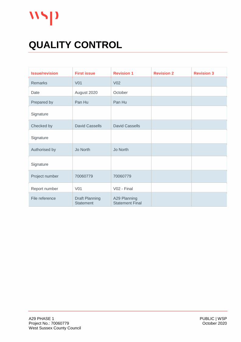
QUALITY CONTROL
Issue/revision First issue Revision 1 Revision 2 Revision 3
Remarks V01 V02
Date August 2020 October
Prepared by Pan Hu Pan Hu
Signature
Checked by David Cassells David Cassells
Signature
Authorised by Jo North Jo North
Signature
Project number 70060779 70060779
Report number V01 V02 - Final
File reference Draft Planning Statement
A29 Planning Statement Final
A29 PHASE 1 PUBLIC | WSP Project No.: 70060779 October 2020 West Sussex County Council
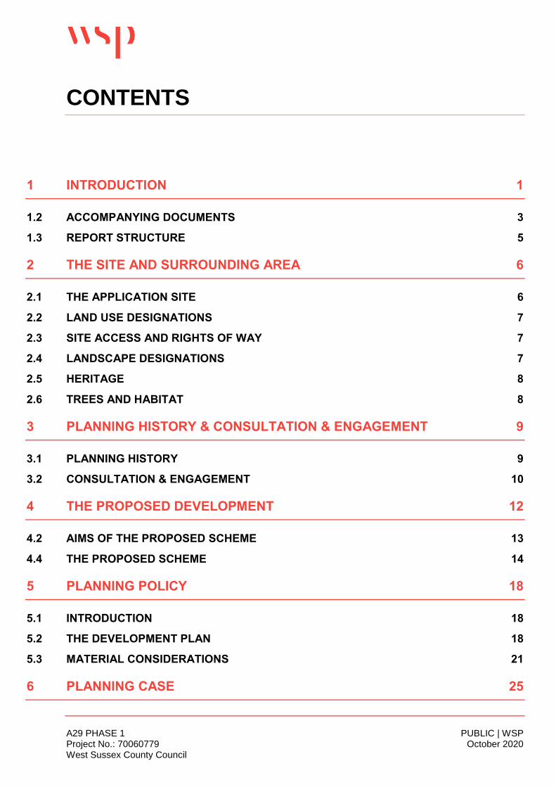
CONTENTS
1 INTRODUCTION 1
1.2 ACCOMPANYING DOCUMENTS 3
1.3 REPORT STRUCTURE 5
2 THE SITE AND SURROUNDING AREA 6
2.1 THE APPLICATION SITE 6
2.2 LAND USE DESIGNATIONS 7
2.3 SITE ACCESS AND RIGHTS OF WAY 7
2.4 LANDSCAPE DESIGNATIONS 7
2.5 HERITAGE 8
2.6 TREES AND HABITAT 8
3 PLANNING HISTORY & CONSULTATION & ENGAGEMENT 9
3.1 PLANNING HISTORY 9
3.2 CONSULTATION & ENGAGEMENT 10
4 THE PROPOSED DEVELOPMENT 12
4.2 AIMS OF THE PROPOSED SCHEME 13
4.4 THE PROPOSED SCHEME 14
5 PLANNING POLICY 18
5.1 INTRODUCTION 18
5.2 THE DEVELOPMENT PLAN 18
5.3 MATERIAL CONSIDERATIONS 21
6 PLANNING CASE 25

A29 PHASE 1 PUBLIC | WSP Project No.: 70060779 October 2020 West Sussex County Council
6.1 INTRODUCTION 25
6.2 PRINCIPLE OF THE DEVELOPMENT 25
6.3 HIGHWAYS AND SUSTAINABLE TRAVEL 30
6.4 DESIGN QUALITY 32
6.5 ENVIRONMENMTAL CONSIDERATIONS 34
7 CONCLUSION 41
TABLES
Table 1-1 - Application Drawing Schedule 4
Table 3-1 – Relevant Planning Decisions 9
FIGURES
Figure 2-1 - Application Site Boundary 6
Figure 4-1 - Temporary Land and Civil Engineering 13
Figure 6-1 - C2C LEP Area and Priority Growth Locations including bognor Regis and the
Enterprise Zone 28
Figure 6-2 - Allocated Housing Sites in the ALP 33
Figure 6-3 - Typical Cross Section Plan 34
APPENDICES
Appendix A – Planning Policy
Appendix B – Minerals Safeguarding Statement
Appendix C – Aerodrome Safeguarding Statement
Appendix D – A29 Realignment Consultation Report
Appendix E – Road Safety Audit and Designers Response

A29 PHASE 1 PUBLIC | WSP Project No.: 70060779 October 2020 West Sussex County Council Page 1 of 43
1 INTRODUCTION
1.1.1. This Planning Statement has been prepared by WSP on behalf of West Sussex County Council
(WSCC) (“The Applicant”) and accompanies a Planning Application including Environmental
Statement (ES), for Phase 1 of the A29 Realignment Scheme (“the Proposed Scheme”) comprising
the “The construction of a 1.3km single carriageway with a 3m wide shared cycleway / footway, ,
one uncontrolled pedestrian crossing to enable users of the Public Right of Way to cross the
carriageway, three roundabouts, provision of hard and soft landscaping, road markings, traffic
signals, bus stops, and signalised pedestrian crossings, construction of a substation building;
installation of a noise barrier, and other associated works” on land to the north of Eastergate and to
the north west of Barnham, within Arun District, to the north of Bognor Regis. The location is shown
in Figure 1-1.
Figure 1-1 – Location Plan
1.1.2. Phase 1 is the proposed northern section of the A29 Realignment Scheme. It would connect the A29
south of Eastergate Lane to the B2233 Barnham Road, west of Downfield Road. Phase 2 would be
separately designed and consented and therefore, this Planning Application relates solely to Phase
1. The location of Phase 1 and Phase 2 is shown in Figure 1-2.

A29 PHASE 1 PUBLIC | WSP Project No.: 70060779 October 2020 West Sussex County Council Page 2 of 43
Figure 1-2 – Phase 1 and 2
1.1.3. The Planning Application will be submitted to West Sussex County Council as the determining Local
Planning Authority (“LPA”) for Highway development, under Regulation 3 of The Town and Country
Planning General Regulations 1992.
1.1.4. A full description of the Proposed Scheme is set out in Section 3 of this Statement and the location
of the site is shown on the Site Boundary Plan drawing ref. no A29-CAP-HPN-00-DR-C-0174.
1.1.5. The Proposed Scheme represents an important part of WSCC’s strategy to support growth,
development and housing in the Bogner Regis area. It will
Create capacity for expected traffic growth;
Enable the local road network to operate more efficiently by reducing congestion;
Improve the reliability of journey times; and
Tackle the planned and potential development to support the delivery of around 11,400 new
dwellings and 104,000sqm of commercial development on permitted or planned development
sites in this part of Arun District.
1.1.6. The Proposed Scheme will also support delivery of the LEP Strategic Economic Plan and Local
Growth Deal.
1.1.7. This Planning Statement describes the need for the Proposed Scheme and how it fits into a wider
strategy for the ambitious growth and development of housing in Barnham, Eastergate and
A29 PHASE 1 PUBLIC | WSP Project No.: 70060779 October 2020 West Sussex County Council Page 3 of 43
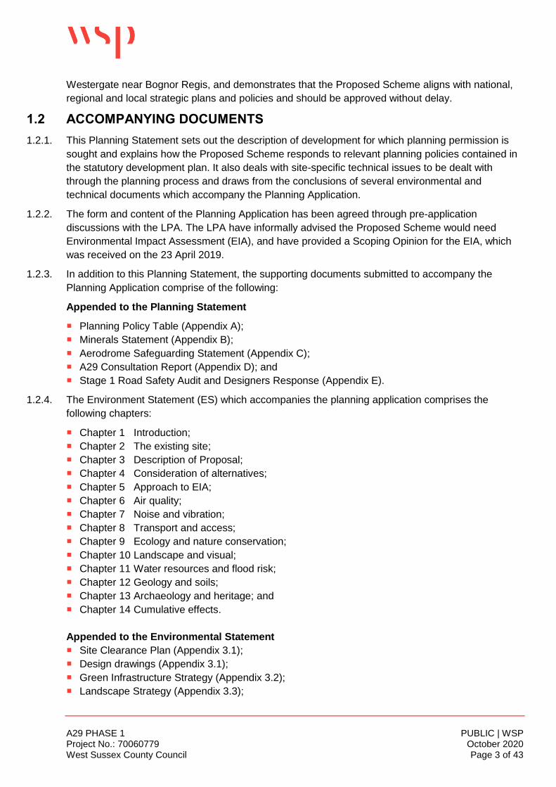
Westergate near Bognor Regis, and demonstrates that the Proposed Scheme aligns with national,
regional and local strategic plans and policies and should be approved without delay.
1.2 ACCOMPANYING DOCUMENTS
1.2.1. This Planning Statement sets out the description of development for which planning permission is
sought and explains how the Proposed Scheme responds to relevant planning policies contained in
the statutory development plan. It also deals with site-specific technical issues to be dealt with
through the planning process and draws from the conclusions of several environmental and
technical documents which accompany the Planning Application.
1.2.2. The form and content of the Planning Application has been agreed through pre-application
discussions with the LPA. The LPA have informally advised the Proposed Scheme would need
Environmental Impact Assessment (EIA), and have provided a Scoping Opinion for the EIA, which
was received on the 23 April 2019.
1.2.3. In addition to this Planning Statement, the supporting documents submitted to accompany the
Planning Application comprise of the following:
Appended to the Planning Statement
Planning Policy Table (Appendix A);
Minerals Statement (Appendix B);
Aerodrome Safeguarding Statement (Appendix C);
A29 Consultation Report (Appendix D); and
Stage 1 Road Safety Audit and Designers Response (Appendix E).
1.2.4. The Environment Statement (ES) which accompanies the planning application comprises the
following chapters:
Chapter 1 Introduction;
Chapter 2 The existing site;
Chapter 3 Description of Proposal;
Chapter 4 Consideration of alternatives;
Chapter 5 Approach to EIA;
Chapter 6 Air quality;
Chapter 7 Noise and vibration;
Chapter 8 Transport and access;
Chapter 9 Ecology and nature conservation;
Chapter 10 Landscape and visual;
Chapter 11 Water resources and flood risk;
Chapter 12 Geology and soils;
Chapter 13 Archaeology and heritage; and
Chapter 14 Cumulative effects.
Appended to the Environmental Statement
Site Clearance Plan (Appendix 3.1);
Design drawings (Appendix 3.1);
Green Infrastructure Strategy (Appendix 3.2);
Landscape Strategy (Appendix 3.3);
A29 PHASE 1 PUBLIC | WSP Project No.: 70060779 October 2020 West Sussex County Council Page 4 of 43
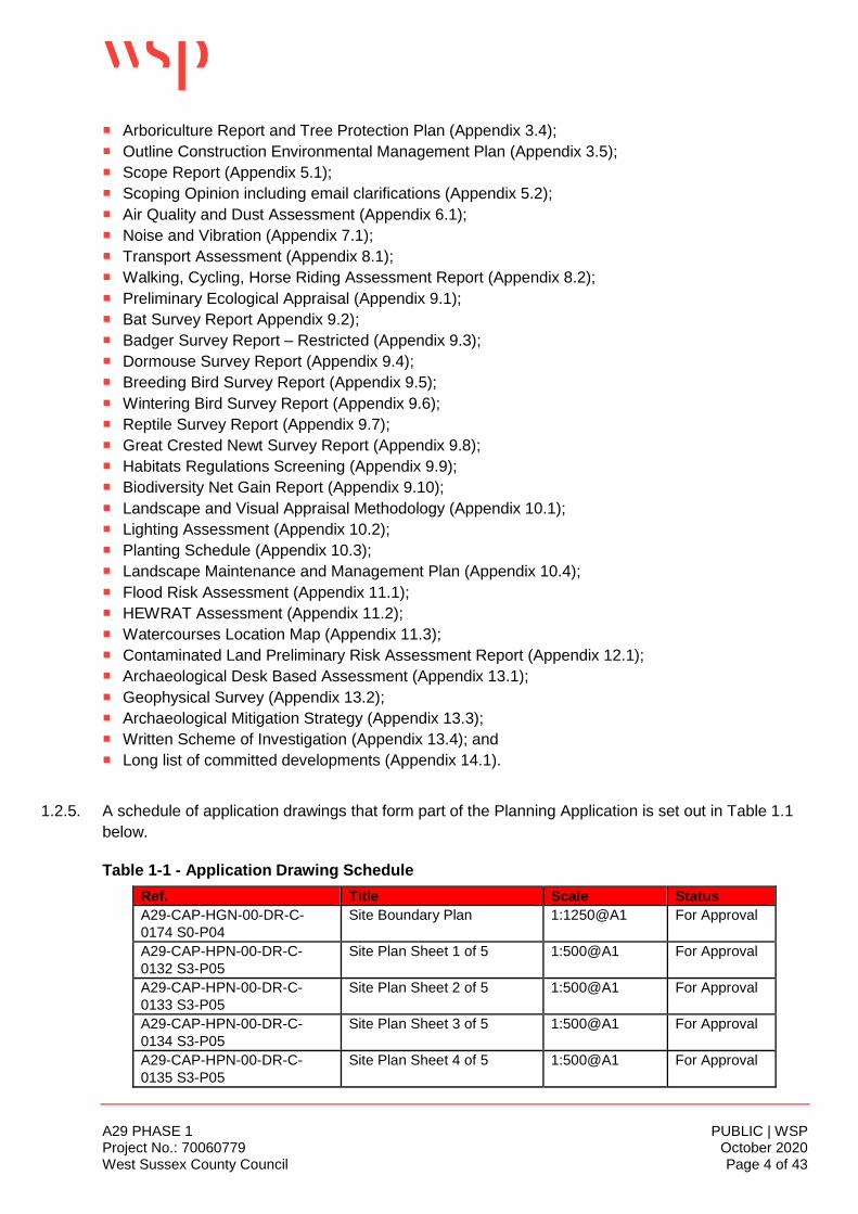
Arboriculture Report and Tree Protection Plan (Appendix 3.4);
Outline Construction Environmental Management Plan (Appendix 3.5);
Scope Report (Appendix 5.1);
Scoping Opinion including email clarifications (Appendix 5.2);
Air Quality and Dust Assessment (Appendix 6.1);
Noise and Vibration (Appendix 7.1);
Transport Assessment (Appendix 8.1);
Walking, Cycling, Horse Riding Assessment Report (Appendix 8.2);
Preliminary Ecological Appraisal (Appendix 9.1);
Bat Survey Report Appendix 9.2);
Badger Survey Report – Restricted (Appendix 9.3);
Dormouse Survey Report (Appendix 9.4);
Breeding Bird Survey Report (Appendix 9.5);
Wintering Bird Survey Report (Appendix 9.6);
Reptile Survey Report (Appendix 9.7);
Great Crested Newt Survey Report (Appendix 9.8);
Habitats Regulations Screening (Appendix 9.9);
Biodiversity Net Gain Report (Appendix 9.10);
Landscape and Visual Appraisal Methodology (Appendix 10.1);
Lighting Assessment (Appendix 10.2);
Planting Schedule (Appendix 10.3);
Landscape Maintenance and Management Plan (Appendix 10.4);
Flood Risk Assessment (Appendix 11.1);
HEWRAT Assessment (Appendix 11.2);
Watercourses Location Map (Appendix 11.3);
Contaminated Land Preliminary Risk Assessment Report (Appendix 12.1);
Archaeological Desk Based Assessment (Appendix 13.1);
Geophysical Survey (Appendix 13.2);
Archaeological Mitigation Strategy (Appendix 13.3);
Written Scheme of Investigation (Appendix 13.4); and
Long list of committed developments (Appendix 14.1).
1.2.5. A schedule of application drawings that form part of the Planning Application is set out in Table 1.1
below.
Table 1-1 - Application Drawing Schedule
Ref. Title Scale Status
A29-CAP-HGN-00-DR-C-
0174 S0-P04
Site Boundary Plan 1:1250@A1 For Approval
A29-CAP-HPN-00-DR-C-
0132 S3-P05
Site Plan Sheet 1 of 5 1:500@A1 For Approval
A29-CAP-HPN-00-DR-C-
0133 S3-P05
Site Plan Sheet 2 of 5 1:500@A1 For Approval
A29-CAP-HPN-00-DR-C-
0134 S3-P05
Site Plan Sheet 3 of 5 1:500@A1 For Approval
A29-CAP-HPN-00-DR-C-
0135 S3-P05
Site Plan Sheet 4 of 5 1:500@A1 For Approval

A29 PHASE 1 PUBLIC | WSP Project No.: 70060779 October 2020 West Sussex County Council Page 5 of 43
A29-CAP-HPN-00-DR-C-
0136 S3-P04
Site Plan Sheet 5 of 5 1:500@A1 For Approval
A29-CAP-HPN-00-DR-C-
0175 S0-P03
Plan & Profile Sheet 1 of 4 1:100/1:500@A1 For Approval
A29-CAP-HPN-00-DR-C-
0176 S0-P03
Plan & Profile Sheet 2 of 4 1:100/1:500@A1 For Approval
A29-CAP-HPN-00-DR-C-
0177 S0-P03
Plan & Profile Sheet 3 of 4 1:100/1:500@A1 For Approval
A29-CAP-HPN-00-DR-C-
0178 S0-P04
Plan & Profile Sheet 4 of 4 1:100/1:500@A1 For Approval
A29-CAP-HPN-00-DR-C-
0180 S0-P05
Cross Sections Sheet 1 of 3 1:2500@A1/As
Shown
For Approval
A29-CAP-HPN-00-DR-C-
0181 S0-P05
Cross Sections Sheet 2 of 3 1:2500@A1/As
Shown
For Approval
A29-CAP-HPN-00-DR-C-
0182 S0-P05
Cross Sections Sheet 3 of 3 1:2500@A1/As
Shown
For Approval
A29-CAP-HPN-00-DR-C-
0183 S0-P03
Proposed Elevations Noise
Barrier Sheet 1 of 2
1:500/1:100@A1 For Approval
A29-CAP-HPN-00-DR-C-
0184 S0-P03
Proposed Elevations Noise
Barrier Sheet 2 of 2
1:500/1:100@A1 For Approval
A29-WSP-LA-GA-001 Rev G Soft Landscape Plan Sheet
1 of 5
1:50 @A1 For Approval
A29-WSP-LA-GA-002 Rev G Soft Landscape Plan Sheet
2 of 5
1:50 @A1 For Approval
A29-WSP-LA-GA-003 Rev G Soft Landscape Plan Sheet
3 of 5
1:50 @A1 For Approval
A29-WSP-LA-GA-004 Rev G Soft Landscape Plan Sheet
4 of 5
1:50 @A1 For Approval
A29-WSP-LA-GA-005 Rev G Soft Landscape Plan Sheet
5 of 5
1:50 @A1 For Approval
A29-CAP-HDG-00DR-C-0047
Rev P08
Drainage Strategy Layout 1:1250@A1 For Approval
1.3 REPORT STRUCTURE
1.3.1. This Planning Statement is structured as follows:
Section 2 describes the Application Site and surrounding;
Section 3 describes how the Proposed Scheme has evolved and provides a detailed description
of the development;
Section 4 lists relevant planning decisions relating to the application site;
Section 5 provides a summary of the relevant planning policy context;
Section 6 sets out the planning case, in particular, outlines how the Proposed Scheme responds
to policy as well as other material considerations; and
Section 7 sets out the benefits of the Proposed Scheme and provides a summary and overall
conclusion.

A29 PHASE 1 PUBLIC | WSP Project No.: 70060779 October 2020 West Sussex County Council Page 6 of 43
2 THE SITE AND SURROUNDING AREA
2.1 THE APPLICATION SITE
2.1.1. The Application Site is shown on the Application Site Boundary Plan drawing no. A29-CAP-HPN-00-
DR-C-0174, and in Figure 2.1. It is approximately 11.8 hectares (ha) in size comprising 9.2ha of
land for the Proposed Scheme and an additional 2.6ha of land for use temporarily for construction
compounds and access, required to implement to Proposed Scheme.
Figure 2-1 - Application Site Boundary
2.1.2. From the northwest, the Application Site begins on the A29 Fontwell Avenue at its junction with
Northfield Farmhouse and Eastgate Lane. It extends approximately 214m south west along the A29
Fontwell Avenue to a point opposite Westview, a detached residential property located on the east
side of Fontwell Avenue and incorporating Folly Foot Farm. At this point, the Application Site
extends approximately 818m south east over arable fields, woodland, orchard and areas of
managed grassland where it abuts the north west boundary of the properties in Ewens Gardens.

A29 PHASE 1 PUBLIC | WSP Project No.: 70060779 October 2020 West Sussex County Council Page 7 of 43
2.1.3. At this point, the Application Site extends south west for a distance of approximately 549m,
bordering the north western boundary of the properties in Murrell Gardens, and extending between
the south eastern boundary of Fordingbridge Industrial Estate and the side boundary with
Greenoaks, a detached property, until it joins the B2233 Barnham Road. At this point, the
Application Site extends approximately 214m along the B2233 Barnham Road between the frontage
of Fordingbridge Industrial Estate to the north west and its junction with Downview Road to the south
east.
2.1.4. From the B2233 Barnham Road, the Application Site extends approximately 241m further south
west over land currently occupied by Fleurie Nursery.
2.1.5. As mentioned above, the Application Site extends over arable fields, woodland, orchard and areas
of managed grassland. The land is classified as having high quality agricultural land (Grade 1),
however, an Agricultural Land Classification Assessment was not required as the principal for the
Proposed Scheme in this location on agricultural land has already been established through the
adopted local plan.
2.2 LAND USE DESIGNATIONS
2.2.1. The Application Site extends over the following land use designations as identified in the adopted
Arun Local Plan (ALP) 2018:
Built-up Area Boundary (Barnham);
Indicative Alignment of A29 Bypass (Policy T SP3 (k));
Site specific Strategic Housing Allocation SD5 (Barnham/Eastergate/Westergate – allocated
2,300 units); and
Sharp Sand and Gravel Minerals Safeguarding area.
2.2.2. The Application Site lies within the area boundary of Barnham and Eastergate Neighbourhood plan,
and the vast majority of the site lies within Flood Zone 1, with the site boundary’s eastern edge
within Flood Zone 3.
2.2.3. The Application Site is also within 15km of an aerodrome (6.7km from Goodwood Aerodrome), and
therefore an Aerodrome Safeguarding Statement has been prepared to support this Planning
Application, in accordance with the WSCC Validation Local List (2017).
2.3 SITE ACCESS AND RIGHTS OF WAY
2.3.1. Currently the vehicular access to the Site is via farm tracks, and through private land owned by local
residents, local farms and businesses.
2.3.2. Footpath 318, a north-south running public right of way (PRoW), crosses the site between the
B2233 Barnham Road and Eastergate Lane.
2.4 LANDSCAPE DESIGNATIONS
2.4.1. The South Downs National Park is located approximately 1.4km north of the Application Site.
2.4.2. The Application Site also lies within National Character Area (NCA) 126 – South Coast Plain. This
National Character Area is characterised by a flat, coastal landscape with an intricately indented
shoreland and contains several major inlets.

A29 PHASE 1 PUBLIC | WSP Project No.: 70060779 October 2020 West Sussex County Council Page 8 of 43
2.4.3. WSCC’s Landscape Character Assessment (2003) identifies the Application Site as part of
Landscape Character SC8 Fontwell Upper Coastal Plain and is described as a transition area
between the open lower Coastal Plain to the south and the wooded Downs to the north.
2.4.4. At a local level, the Application Site lies within the following landscape character areas and/or zones
as identified in the Arun Landscape Study (2006):
Zone 2 – Five Villages (Eastergate, Westergate, Walberton, Barnham, Yapton); and
LCA16: Fontwell-Eastergate Mosaic.
2.5 HERITAGE
2.5.1. There are no heritage designated assets within the Application Site. The Eastergate (Church Lane)
and Eastergate Square Conservation Areas are located approximately 430m south-east of the
Scheme and there are 26 listed buildings within 1km of the Site, which include Grade II* Parish of St
George.
2.6 TREES AND HABITAT
2.6.1. A total of 19 trees and one tree group have been identified as being afforded protection by virtue of
TPO BN/1/20. All of the individual trees are pedunculate oak whilst tree group G37 is recorded as
comprising of a number of hornbeams. Features protected by TPO BN/1/20 are located towards the
northernmost extent of the Scheme and on land east of Fontwell Avenue and south of Eastergate
Lane.
2.6.2. There are also two potential veteran trees located on the eastern side of public footpath 318 and
towards its northern end.
2.6.3. All tree locations are identified within the Tree Protection Plan included in Appendix 3.4 of the ES.
2.6.4. Much of the site is identified as priority habitat (traditional orchards and woodland) in the Priority
Habitat Inventory (England) and Priority Habitat Network (England). Habitats of Principal Importance
(HPI) are identified throughout the Site (specifically, traditional orchards and woodland).

A29 PHASE 1 PUBLIC | WSP Project No.: 70060779 October 2020 West Sussex County Council Page 9 of 43
3 PLANNING HISTORY & CONSULTATION & ENGAGEMENT
3.1 PLANNING HISTORY
3.1.1. This section lists the relevant planning decisions obtained from the West Sussex and Arun District
Council (ADC) websites. The site’s immediate surrounding area has had various outline approvals
for primarily residential schemes, which have been taken into consideration in assessing the
cumulative impact effects.
3.1.2. A full list of committed schemes is found in the ES. Table 3.1 below lists those planning decisions
located within 1.5km of the Application Site that are likely to affect nearby road network capacities.
Table 3-1 – Relevant Planning Decisions
Reference Name of Committed Development
Status Distance from Site
Proposal and Material Reviewed to Inform Assessment
2 Land East of Fontwell Avenue
Approved 0.6 km north
Outline application with some reserved matters to provide up to 400 new dwellings, up to 500 m2 of non-residential floorspace (A1, A2, A3, D1 and / or D2), 5000 m2 of light industrial floorspace (B1 (b)/(c)) and associated works including access, internal road network, highway network, highway works, landscaping, selected tree removal, informal and formal open space and play areas, pedestrian and cyclist infrastructure, car and cycle parking and waste storage.
https://www1.arun.gov.uk/PublicViewer/Authenticated/Main.aspx?user_key_1=WA/22/15/OUT
4 Land at Former Eastergate Fruit Farm
Approved 0.3 km west
Outline application for the erection of 60 residential dwellings with new vehicular access, open space and other ancillary works at Land at former Eastergate Fruit Farm.
https://www1.arun.gov.uk/PublicViewer/Authenticated/Main.aspx?user_key_1=EG/71/14/OUT
5 Pollards Nursery Lake
Approved 1.3 km south-east
Outline application with some reserved matters for development of up to 107 residential units (this application is a departure from the development plan) at Pollards Nursery Lake Lane.
https://www1.arun.gov.uk/PublicViewer/Authenticated/Main.aspx?user_key_1=BN/16/12/
6 Land West of Westergate Street & East of Hook Lane
Approved 1.4 km south-west
Reserved matters application following outline planning permission AL/39/13 for the demolition of Oakdene and all other structures within the site and the erection of 79 dwellings, public open space, children’s play areas, landscaping, drainage measures, sub-station, pumping

A29 PHASE 1 PUBLIC | WSP Project No.: 70060779 October 2020 West Sussex County Council Page 10 of 43
station and all other associated works at Land West of Westergate Street & East of Hook Lane.
https://www1.arun.gov.uk/PublicViewer/Authenticated/Main.aspx?user_key_1=AL/107/16/RES
7 Angels Nursery
Approved 1.3 km south-east
Application for 95 dwellings together with access, landscaping open space and associated works at Angels Nursery.
https://www1.arun.gov.uk/PublicViewer/Authenticated/Main.aspx?user_key_1=BN/43/16/PL
8 Barnfield House
Approved 1.3 km north
Outline application with all matter reserved for residential development comprising of 22 developments involving demolition of Barnfield House and existing outbuildings.
https://www1.arun.gov.uk/PublicViewer/Authenticated/Main.aspx?user_key_1=WA/23/17/OUT
9 Lillies Approved 1.4 km south-east
Approval of reserved matters following outline consent BN/32/15/OUT relating to appearance, landscaping, layout and scale for erection of 38 dwellings including open space, landscaping and new access (resubmission following BN/28/17/RES) at Lillies.
https://www1.arun.gov.uk/PublicViewer/Authenticated/Main.aspx?user_key_1=BN/6/18/RES
15 Land west of Fontwell Avenue
Undecided 0.2 km north
Demolition of existing structures and erection of 42 dwellings with access, parking, landscaping and associated works.
https://www1.arun.gov.uk/PublicViewer/Authenticated/Main.aspx?user_key_1=BN/50/20/PL
3.2 CONSULTATION & ENGAGEMENT
3.2.1. WSCC consulted with the public and local stakeholders on the A29 Realignment Scheme in 2019
during preparation of the Outline Business Case, which considered both Phases 1 and 2. Full details
of the consultation process and responses to comments received can be found in the ‘A29
Realignment Consultation Report’ which accompanies this Planning Application.
3.2.2. In summary, the consultation was promoted on the scheme webpage
www.westsussex.gov.uk/A29Realignment and leaflets announcing the consultation were distributed
to businesses and households within the scheme area. A press release was issued a week before
public consultation began, announcing the proposals and promoting the exhibition events. Another
press release was issued a week before the end of the consultation to encourage further
participation.
3.2.3. Four public exhibition events were held across the following dates and locations:
Barnham Community Hall 26 February 2019;
A29 PHASE 1 PUBLIC | WSP Project No.: 70060779 October 2020 West Sussex County Council Page 11 of 43
Westergate Church Hill 27 February 2019;
Eastergate Village Hill 28 February 2019; and
St Philip Howard Catholic School 2 March 2019.
3.2.4. A consultation questionnaire was used to gather feedback on the design of the proposed road
realignment, to identify local concerns and priorities in the development of the scheme and to find
out more about how people travel in the area.
3.2.5. Stakeholders, businesses and local residents were encouraged to provide their feedback on the
proposals. The level of response is as follows:
A total of 518 responses were received.
These included 488 questionnaires and 30 written responses (letters, emails) received by post or
email.
A total of 958 people attended the public exhibitions.
3.2.6. The key findings of the consultation found:
Questionnaire respondents have concerns about many aspects of the proposed A29
Realignment scheme, in particular:
• 90% are concerned about disruption during construction
• 89% are concerned about the impact on existing residential properties
• 87% are concerned about noise, light or air pollution
• 87% are concerned about impact on landscape and scenery
• 85% are concerned about congestion and journey time
• 84% are concerned about road safety
• 82% are concerned about impact on routes used by people walking, cycling and horse riding
When asked to give more detail about local issues that should be considered in the development
of the scheme, many respondents took the opportunity to demonstrate objection to the scheme in
general including the housing development. They also raised concerns that the proposed scheme
will result in localised increases in traffic and congestion, and that it will impact on the identity of
local villages.
With regard to Phase 1 (North) design proposals:
• Respondents are mostly concerned about potential traffic conflicts on Barnham Road,
Fontwell Avenue and Fontwell roundabout.
• Respondents have suggested realigning the northern link to the A27 at Fontwell or moving it
away from Eastergate Lane junction.
• Other suggestions included the need for greater provision for non-motorised users, including
dedicated and segregated pathways and crossing provision. The need for traffic lights at
roundabouts in the northern section was also mentioned.
3.2.7. The information relating to Phase 1 gathered from this consultation was considered alongside other
technical assessment information to develop the preferred option scheme for which planning
permission is being sought.

A29 PHASE 1 PUBLIC | WSP Project No.: 70060779 October 2020 West Sussex County Council Page 12 of 43
4 THE PROPOSED DEVELOPMENT
4.1.1. This section provides a description of the Proposed Scheme and describes how the design has
evolved to the preferred option’. It should be read in conjunction with ES Chapter 3 Description of
Scheme.
4.1.2. Planning permission is sought for:
4.1.3. “The construction of a 1.3km single carriageway with a 3m wide shared cycleway / footway, , one
uncontrolled pedestrian crossing to enable users of the PRoW to cross the carriageway, three
roundabouts, provision of hard and soft landscaping, road markings, traffic signals, bus stops, and
signalised pedestrian crossings, construction of a substation building; installation of a noise barrier,
and other associated works”
4.1.4. The realignment of the A29 (Phases 1 & 2) will create capacity for expected traffic growth and will
tackle planned and potential development to support the delivery of around 11,400 new dwellings
and 104,000sqm of commercial development on permitted or planned development sites in this part
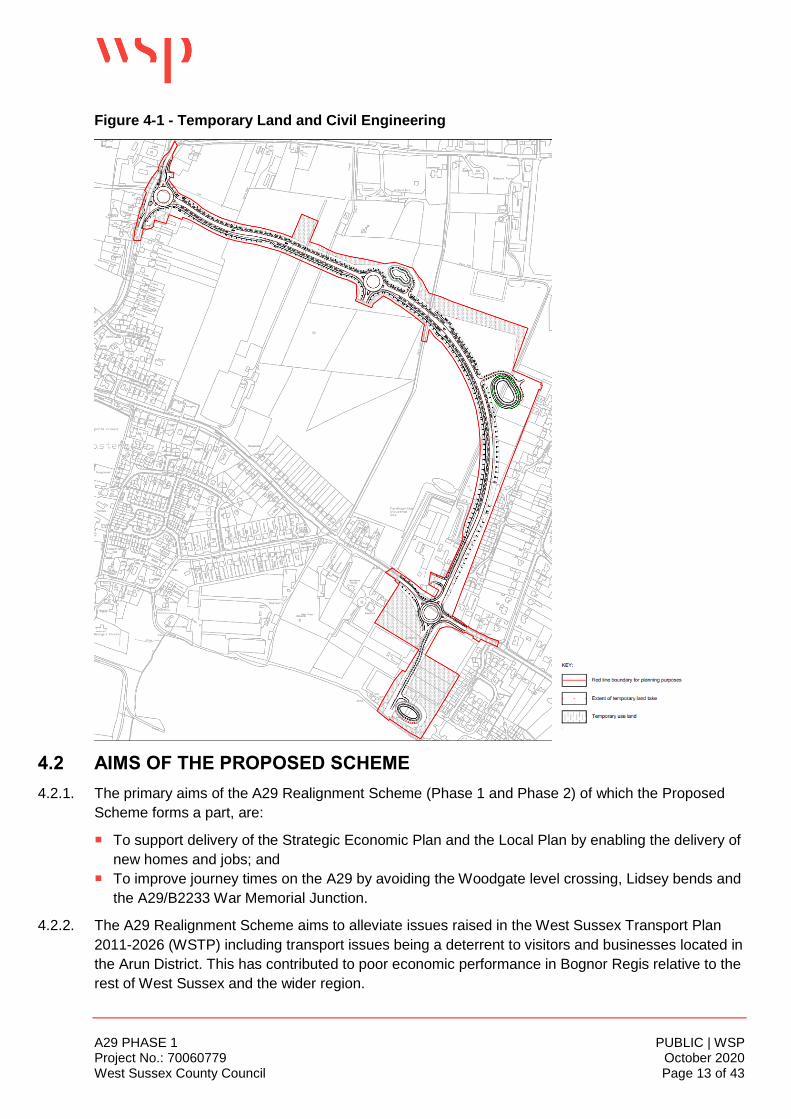
of Arun District.
4.1.5. The extent of land required to deliver the Proposed Scheme is set out in Figure 4.1 below. It
comprises a combination of permanent and temporary land. Post construction, the temporary land
areas will be made good and returned to its current use as open green fields.
A29 PHASE 1 PUBLIC | WSP Project No.: 70060779 October 2020 West Sussex County Council Page 13 of 43
Figure 4-1 - Temporary Land and Civil Engineering
4.2 AIMS OF THE PROPOSED SCHEME
4.2.1. The primary aims of the A29 Realignment Scheme (Phase 1 and Phase 2) of which the Proposed
Scheme forms a part, are:
To support delivery of the Strategic Economic Plan and the Local Plan by enabling the delivery of
new homes and jobs; and
To improve journey times on the A29 by avoiding the Woodgate level crossing, Lidsey bends and
the A29/B2233 War Memorial Junction.
4.2.2. The A29 Realignment Scheme aims to alleviate issues raised in the West Sussex Transport Plan
2011-2026 (WSTP) including transport issues being a deterrent to visitors and businesses located in
the Arun District. This has contributed to poor economic performance in Bognor Regis relative to the
rest of West Sussex and the wider region.

A29 PHASE 1 PUBLIC | WSP Project No.: 70060779 October 2020 West Sussex County Council Page 14 of 43
4.2.3. Significant new housing is planned in the area which is expected to increase demand on the A29
and B2233 roads. An application for up to 5001 homes on the land to the east of Fontwell Avenue is
required to deliver a proposed 2,300 homes at the Barnham, Eastergate, Westergate Site during the
ALP period (2011-2031), with potential on the Site for a further 700 dwellings to be delivered after
2031 (refer to Figure 1-1). This site allocated for housing would be contrary to the provisions of the
National Planning Policy Framework (NPPF) regarding “severe residual cumulative impact” (NPPF
Para 109) without the delivery of the A29 realignment scheme, based on the Arun District Local Plan
Transport Study 2017.
4.3 DESIGN DEVELOPMENT
4.3.1. Several feasibility and viability studies to inform the Proposed Scheme were undertaken since 2012.
The main studies were:
Parsons Brinckerhoff - A29 Woodgate Study, 2012;
MVA (now Systra Ltd) - A29 Realignment Viability Study, 2013; and
Systra - A29 Realignment Feasibility Study, 2014.
4.3.2. Since the last study in 2014, ADC and WSCC continued to work with developers to prepare a
Masterplan vision for the area to allow the land to be opened up for housing, schools, and other
uses.
4.3.3. Building upon the 2014 Systra Report, an Option Summary Table was prepared focusing on the
advantages and disadvantages of the options considered in previous studies. These options were
then taken to consultation with stakeholders who, along with further traffic modelling, determined
that Phase 1 (Route 6) and Phase 2 (Part D and 12) was the most appropriate options that would
deliver WSCC’s aims and aspirations for this area.
4.4 THE PROPOSED SCHEME
4.4.1. Full details of the Proposed Scheme (Phase 1 only) are shown on the Site Layout Plan drawing nos.
A29-CAP-HPN-00-DR-C-0132 to – 0136 (consec). The topography within the Site varies between 8
and 16 metres above ordnance datum (m AOD). The existing ground profile in general falls from
Fontwell Avenue towards Barnham Road. The proposed levels are shown on the A29 Link Road
Plan & Profile drawing no. A29-CAP-HPN-00-DR-C-0175 to -0178 (consec).
4.4.2. From the northwest, the Proposed Scheme commences with a three-arm roundabout at a new
junction with the A29 Fontwell Avenue, as shown on drawing no. A29-CAP-HPN-00-DR-C-0132.
The new road itself will have an average width of 7.3m and finished in asphalt. Uncontrolled
pedestrian crossings are proposed at the northern and eastern arms, a grass verge is proposed for
most of the western length, and footways are proposed along the north and south eastern arms, of
this new roundabout.
4.4.3. From this new roundabout, the new 7.3m carriageway extends south east to join another three-arm
roundabout, as shown on drawing no. A29-CAP-HPN-00-DR-C-0133. This new roundabout will
1 Barnham Road, Eastergate Environmental Impact Assessment Scoping Report BDW, (Wyg, November 2019).

A29 PHASE 1 PUBLIC | WSP Project No.: 70060779 October 2020 West Sussex County Council Page 15 of 43
provide future access to the Barrett Homes housing site. An attenuation pond 1m below existing
ground level (EGL) with an approximate volume of 400m3 is proposed to the east of this new
roundabout. An access road to the attenuation pond is also proposed. The attenuation pond will be
required to store and control the flow of excess drainage, surface water and stormwater. Water is
then slowly released from the attenuation pond or solution in a controlled manner.
4.4.4. The new carriageway will continue south east to a point where it will provide an uncontrolled
pedestrian crossing to enable users of the PRoW to cross the carriageway, also shown on drawing
no. A29-CAP-HPN-00-DR-C-0133. After, the new carriageway will bend and head in a south
westerly direction, as shown on drawing no. A29-CAP-HPN-00-DR-C-0134. Another attenuation
pond, also 1m below EGL but with an approximate volume of 900m3, and associated access road,
are also proposed on land east of the new carriageway and north west (rear) of 31A and 31B Ewens
Gardens, two detached residential dwellings.
4.4.5. The new carriageway will extend south west boarding the north western boundary of the properties
in Murrell Gardens, extending between the south eastern boundary of Fordingbridge Industrial
Estate and the side boundary with Greenoaks, a detached property, until it joins a new four-arm
roundabout at a new junction with the B2233 Barnham Road, as shown on drawing no. A29-CAP-
HPN-00-DR-C-0135. This new roundabout will comprise 3no. uncontrolled pedestrian crossings on
its north, east and southern arms; a combination of 3m wide shared footway/cycle ways and/or 2m
wide footways at the northern and eastern arms; a grass verge for most of the western length, and
footways along the north and south eastern arms. A new access is proposed into the Fordingbridge
Industrial Estate from the new section of carriageway proposed north of the B2233 Barnham Road.
The Proposed Scheme will tie into the A29 Fontwell Avenue to the north west and the B2233
Barnham Road to the south west.
4.4.6. The majority of the new carriageway will be built upon a small embankment to avoid road
construction within areas of high groundwater levels. Drainage swales, filter drains and a grass filter
strip are proposed adjacent to the carriageway to catch and filter ‘over the edge’ surface runoff. Key
features of the Proposed Scheme include the following; some of which are discussed in more details
below:
Planters at certain points along the carriageway;
Engineering earthworks, 5m grassed verges with 4m Swales;
Landscaped areas at certain points along the carriageway;
3m wide shared footways;
2m wide footways; and
Street lighting not exceeding 10m high at roundabout approaches.
4.4.7. Typical sections of the proposed new carriageway layout are shown on the Cross Sections drawing
nos. A29-CAP-HPN-00-DR-C-0180 to -0182 (consec).
4.4.8. Beyond the B2233 Barnham Road, the new carriageway will link onto a temporary haulage road
over land currently occupied by Fleurie Nursery. This temporary road will provide access to a works
compound (Compound A) comprising main site offices, staff parking, meetings, contract admin, and
welfare. It will also provide access to an attenuation pond, also 1m below EGL with an approximate
volume of 900m3, and its future access road.
4.4.9. Two further construction compounds are proposed, all of which will be in-situ for the entire duration
of the construction works:

A29 PHASE 1 PUBLIC | WSP Project No.: 70060779 October 2020 West Sussex County Council Page 16 of 43
Compound B – just off A29 Fontwell Avenue. This will provide localised staff parking, welfare and
some plant and materials.
Compound C – halfway along the Proposed Scheme adjacent to Pond 3, offline from the new
carriageway alignment. This is for storing topsoil and other materials.
4.4.10. Once constructed the realigned section of A29 would be subject to a 30mph speed limit.
Operational access and movement
4.4.11. There are two proposed access routes for the Site, both of these would be used for the Proposed
Scheme. The access route at the western end will join Fontwell Avenue, which runs north-to-south
along the western side of the Site. The other access route will join the B2233 Barnham Road which
runs east-to-west along the southern side of the Site.
4.4.12. Traffic from the existing A29 route will use the A29 Realignment route (both phases), alleviating
pressure on the surrounding transport network. Residents from the new Barrett Homes housing
scheme will also utilise the Proposed Scheme in the operational phase (there will also be access to
the new housing development directly from Barnham Road).
4.4.13. The Proposed Scheme will include a new access to the Fordingbridge Industrial Estate, north of the
roundabout on Barnham Road.
4.4.14. Non-motorised users will be able to use the Proposed Scheme via a 3m wide footpath/ cycleway
(Shared Use Path) along the entire length of the Scheme. An uncontrolled pedestrian crossing is
incorporated into the road design to enable users of the PRoW to safely cross the carriageway. The
Shared Use Path will connect to existing PRoW adjacent to the Site.
Proposed levels and elevations
4.4.15. Street lighting at the junctions will be the tallest feature associated with the Proposed Scheme.
These are most likely to be 6-8m in height and will not exceed a maximum height of 10m (allowing
for raised foundations).
Proposed excavation extents
4.4.16. The only area of new carriageway that will be in cutting is at the north west end with A29 Fontwell
Avenue, as shown on the ‘A29 Link Road Plan & Profile drawing no. A29-CAP-HPN-00-DR-C-0175,
before being on slight embankment for the remainder of the Proposed Scheme. Cutting depths are
currently envisaged to be up to 2m. Highway gradients have been set to minimums (or just above
minimum) to minimise fill above ground levels.
4.4.17. Drainage swales are proposed adjacent to the carriageway – in these areas the road surface runoff
is “over the edge” into the swales. A grass filter strip is also proposed between the future
carriageway and the proposed swales. Due to the relatively impermeable nature of the ground,
pipes are proposed to generally run under the swales to convey the higher critical design storm
flows. Infiltration crates are proposed within and adjacent to the proposed Barnham Road
roundabout.
4.4.18. Excavations for drainage will be up to 1.7m from the adjacent new road finished level, and for
utilities and substation relocation up to 1.5m.
Noise Barrier
4.4.19. A noise barrier is located on the eastern side of the Proposed Scheme running between the new
road alignment and the properties on Murrell Gardens, as shown on the Proposed Elevations Noise
Barrier drawing nos. A29-CAP-HPN-00-DR-C-0183 and -0184 (consec). The barrier is 3m high,

A29 PHASE 1 PUBLIC | WSP Project No.: 70060779 October 2020 West Sussex County Council Page 17 of 43
approximately 440m long, and compose absorptive materials to reduce noise onto the existing
properties in Murrell Gardens.
Electricity Sub-Station
4.4.20. The existing electricity substation at Fontwell Avenue will be demolished, and a new replacement
substation will be relocated on land east of the new roundabout at the A29 Fontwell Avenue. It will
measure approximately 4m by 4.5m, with an adjoining cable area approximately 3m by 4m. On the
north side of the substation will be a parking area approximately 3m by 8m. A grasscrete area is
proposed in front of the substation to enable vehicles to reverse off Fontwell Avenue.
Landscaping
4.4.21. The aims of the landscape proposals are to improve biodiversity, provide screening for a noise
barrier and to enhance legibility and connectivity. The proposals sit within the broader overarching
principles outlined in the A29 Green Infrastructure Strategy (2020) (Appendix 3.2 to the ES).
4.4.22. Within the scheme the following plant mixes have been proposed: Orchard, woodland edge,
woodland core, scrub, native hedgerow, wildflower meadow, amenity grass, wetland grass. These
mixes provide 26 native tree and scrub species and 31 native species of grass and wildflower,
providing a large benefit to biodiversity, and creating a visually attractive area along the proposed
footpath and road.
4.4.23. An approximate area of 0.72 hectares will be given to woodland planting, benefiting carbon capture
for the site.
4.4.24. Where feasible the landscape design has connected neighbouring existing vegetation with proposed
vegetation to create wildlife green corridors through the site. The planting mixes contain a variety of
fruiting trees which should provide food for wildlife along these corridors.
A29 PHASE 1 PUBLIC | WSP Project No.: 70060779 October 2020 West Sussex County Council Page 18 of 43
5 PLANNING POLICY
5.1 INTRODUCTION
5.1.1. This section sets out the planning policy context for the A29 Realignment Scheme of which the
Proposed Scheme forms part of. We first consider the Development Plan policies comprising the
ALP 2018 and the Barnham and Eastergate Neighbourhood Plan 2014. We then consider the
national planning policy as set out in the National Planning Policy Framework (NPPF) (revised 2019)
and the West Sussex Transport Plan 2011 – 2026.
5.2 THE DEVELOPMENT PLAN
Arun Local Plan 2011-2031 (adopted July 2018)
5.2.1. The ALP 2011-2031 was adopted on 18th of July 2018. It sets out a spatial vision, objectives and a
sustainable strategy for delivering the needed growth of the District over the period 2011- 2031. The
ALP 2018 is used to guide decisions on planning, development and regeneration activity over this
period including many other decisions shaping corporate investment plans and strategies, as well as
those from external providers, delivering services and infrastructure to the local community.
A full list and text of all relevant policies are contained in Appendix A of this Statement. In summary,
the main relevant policies are:
Policy C SP1 (Countryside) - “Development will be permitted in the countryside where it is for
road and/or cycle schemes”
Policy SD SP1 (Sustainable Development) – “the Council will take a positive approach that
reflects the presumption in favour of sustainable development contained in the National Planning
Policy Framework”.
Policy SD SP1a (Strategic Approach) – “To maintain the District’s unique character as a coastal
location set against the South Downs whilst ensuring that the needs of the community are met
through sustainable growth and the provision of suitable services, the spatial strategy for Arun
District to 2031 is to;
c. provide for growth of the sustainable villages whilst maintaining their setting within the open
countryside
e. provide for the housing needs of the community by delivering 20,000 homes of an appropriate
scale and tenure”
Policy GI SP1 (Green Infrastructure and Development) – “All major development must be
designed to protect and enhance existing Green Infrastructure assets, and the connections
between them, in order to ensure a joined up Green Infrastructure Network. The Green
Infrastructure Network must be protected from light pollution to ensure that areas defined by their
tranquillity are protected from the negative effects of light in development.”
Policy LAN DM1 (Protection of Landscape Character) – “Development within the setting of the
South Downs National Park must have special regard to the conservation of that setting,

A29 PHASE 1 PUBLIC | WSP Project No.: 70060779 October 2020 West Sussex County Council Page 19 of 43
including views into and out of the Park, and will not be permitted where there would be harmful
effects on these considerations.”
Policy D SP1 (Design) – “All development proposals should seek to make efficient use of land but
reflect the characteristics of the site and local area in their layout, landscaping, density, mix,
scale, massing, character, materials, finish and architectural details.”
Policy D DM1 (Aspects of Form and Design Quality) – “When considering any application for
development the Council will have regard to the following aspects; ‘Character’,
‘Appearance/attractiveness’, ‘Impact’, ‘Innovation’, ‘Adaptability’, ‘Trees & Woodland’, ‘Public
Realm’, Layout: movement & legibility’”
Policy T SP1 (Transport and Development) – “To ensure that growth in the District strengthens
Arun's economic base, reduces congestion, works to tackle climate change and promotes healthy
lifestyles; the Council will ensure that development:
- provides safe access on to the highway network;
- contributes to highway improvements and promotes sustainable transport,
- includes public transport improvements and the cycle, pedestrian and bridleway
network.”
Policy T SP3 (Safeguarding the Main Road Network) – “To ensure that improvements necessary
to enhance the strategic and supporting road network within the District can be carried out, the
lines of major road schemes, as shown on the Policies Map, will be protected from development
as follows:
Safeguard the indicative lines of the following schemes, to support the delivery of planned growth
through the Local Plan. These schemes are subject to design, consultation and approval:
j. A29 realignment (southern tie-in)
k. A29 realignment (northern tie-in)”
Policy T DM1 (Sustainable Travel and Public Rights of Way) – “New development must ensure
ease of movement, prioritising safe pedestrian and cycle access to the green infrastructure
network and access to public transport and community transport services where a need has been
identified. Access to alternative modes of transport including public transport services, the public
right of way and cycle networks, must be available and accessible to all members of the
community”
Policy LAN DM1 (Protection of Landscape Character) – “Development within the setting of the
South Downs National Park must have special regard to the conservation of that setting,
including views into and out of the Park, and will not be permitted where there would be harmful
effects on these considerations.”
Policy QE DM1 (Noise Pollution) – “Developers proposing new noise generating development
must seek advice from an early stage to determine the level of noise assessment required.
Proposals will need to be supported by evidence to demonstrate that there are no suitable
alternative locations for the development.”
A29 PHASE 1 PUBLIC | WSP Project No.: 70060779 October 2020 West Sussex County Council Page 20 of 43
Policy QE DM2 (Light Pollution) – “Planning permission for proposals which involve outdoor
lighting must be accompanied by a lighting scheme prepared according to the latest national
design guidance and relevant British Standards publications. Outdoor lighting schemes will be
considered against the following criteria:
a. No adverse impact on neighbouring uses or the wider landscape, particularly with regard the
South Downs International Dark Sky Reserve designation;
b. Light levels being the minimum required for security and working purposes;
c. Minimising the potential glare and spillage; and
d. The degree to which outdoor lighting can be powered by on-site renewable sources.”
Policy QE DM3 (Air Pollution) – “All major development proposals will be required to assess the
likely impacts of the development on air quality and mitigate any negative impacts by:
b. Maximising provision for cycling and pedestrian facilities;
d. Contributing towards the improvement of the highway network where the development is
predicted to result in increased congestion on the highway network.”
Policy QE SP1 (Quality of the Environment) – “The Council requires that all development
contributes positively to the quality of the environment and will ensure that development does not
have a significantly negative impact upon residential amenity [and] the natural environment”
Policy HER SP1 (The Historic Environment) – “The Local Planning Authority will grant planning
permission or relevant consent for development proposals that conserve or enhance the historic
environment of the District”
Policy HER DM6 (Sites of Archaeological Interest) – “There will be a presumption in favour of the
preservation of scheduled and other nationally important monuments and archaeological
remains.”
Barnham and Eastergate Neighbourhood Development Plan 2014-2029
5.2.2. The Barnham and Eastergate Neighbourhood Development Plan 2014-2029 (BENP) sets out the
local vision for the villages of Barnham and Eastergate, together with policies and objectives for
achievement of this vision. The Application Site is included within the spatial coverage of this Plan.
5.2.3. As with the ALP, a full list and text of all relevant policies are contained in Appendix A of this
Statement. In summary, the main relevant Neighbourhood policies are:
GA2 (Footpath and cycle path network) – “Support will be given to proposals that improve and
extend the existing footpath and cycle path network, allowing greater access to new housing, the
village centres, green spaces and the open countryside.”
ES5 (Quality of design) – “All new development with the parishes should be of a high quality
design and will be expected to conform to the forthcoming Barnham and Eastergate Design
Guide once it has been adopted as supplementary planning guidance in accordance with
paragraph 1.41 of the Local Plan.”

A29 PHASE 1 PUBLIC | WSP Project No.: 70060779 October 2020 West Sussex County Council Page 21 of 43
ES1 (Flooding, drainage and new development) – “Planning permission should only be granted
for new development subject to a condition that no development shall commence until full details
of the proposed drainage schemes for surface and foul water (including details of their routing,
design, and subsequent management and maintenance) have been submitted to and approved
by the planning authority”
5.3 MATERIAL CONSIDERATIONS
National Planning Policy Framework
5.3.1. A revised NPPF was published in February 2019 and contains the Government’s current national
planning policies. The purpose of the planning system is to contribute to the achievement of
sustainable development. At a very high level, the objective of sustainable development can be
summarised as meeting the needs of the present without compromising the ability of future
generations to meet their own needs.
5.3.2. Section 2 – ‘Achieving sustainable development’, Paragraph 8 states “Achieving sustainable
development means that the planning system has three overarching objectives, which are
interdependent and need to be pursued in mutually supportive ways (so that opportunities can be
taken to secure net gains across each of the different objectives):
An economic objective – to help build a strong, responsive and competitive economy, by
ensuring that sufficient land of the right types is available in the right places and at the right time
to support growth, innovation and improved productivity; and by identifying and coordinating the
provision of infrastructure;
A social objective – to support strong, vibrant and healthy communities, by ensuring that a
sufficient number and range of homes can be provided to meet the needs of present and future
generations; and by fostering a well-designed and safe built environment, with accessible
services and open spaces that reflect current and future needs and support communities’ health,
social and cultural well-being; and
An environmental objective – to contribute to protecting and enhancing our natural, built and
historic environment; including making effective use of land, helping to improve biodiversity, using
natural resources prudently, minimising waste and pollution, and mitigating and adapting to
climate change, including moving to a low carbon economy”.
5.3.3. At the heart of the NPPF is a presumption in favour of Sustainable Development. Paragraph 10
states “So that sustainable development is pursued in a positive way, at the heart of the Framework
is a presumption in favour of sustainable development”.
5.3.4. Paragraph 11 indicates that “plans and decisions should apply a presumption in favour of
sustainable development. For decision taking this means approving development proposals that
accord with an up-to-date development plan without delay.”
5.3.5. Regarding the status of the Development plan, Paragraph 12 advises that the “presumption in
favour of sustainable development does not change the statutory status of the development plan as
the starting point for decision making. Where a planning application conflicts with an up-to-date
development plan (including any neighbourhood plans that form part of the development plan),
permission should not usually be granted. Local planning authorities may take decisions that depart

A29 PHASE 1 PUBLIC | WSP Project No.: 70060779 October 2020 West Sussex County Council Page 22 of 43
from an up-to-date development plan, but only if material considerations in a particular case indicate
that the plan should not be followed.”
5.3.6. At Section 4 ‘Decision-making’, the NPPF advises Local planning authorities at Paragraph 38 that
they “should approach decisions on proposed development in a positive and creative way. They
should use the full range of planning tools available, including brownfield registers and permission in
principle, and work proactively with applicants to secure developments that will improve the
economic, social and environmental conditions of the area. Decision-makers at every level should
seek to approve applications for sustainable development where possible”
5.3.7. On determining applications, Paragraph 47 advises that “Planning law requires that applications for
planning permission be determined in accordance with the development plan, unless material
considerations indicate otherwise. Decisions on applications should be made as quickly as possible,
and within statutory timescales unless a longer period has been agreed by the applicant in writing.”
5.3.8. At Section 6 ‘Building a strong, competitive economy’, Paragraph 84 states “Planning policies
and decisions should recognise that sites to meet local business and community needs in rural
areas may have to be found adjacent to or beyond existing settlements, and in locations that are not
well served by public transport. In these circumstances it will be important to ensure that
development is sensitive to its surroundings, does not have an unacceptable impact on local roads
and exploits any opportunities to make a location more sustainable (for example by improving the
scope for access on foot, by cycling or by public transport). The use of previously developed land,
and sites that are physically well-related to existing settlements, should be encouraged where
suitable opportunities exist.”
5.3.9. Section 9 sets out the Government’s policies on ‘Promoting sustainable transport’. Paragraph
102 states “Transport issues should be considered from the earliest stages of plan-making and
development proposals, so that:
the potential impacts of development on transport networks can be addressed;
opportunities from existing or proposed transport infrastructure, and changing transport
technology and usage, are realised – for example in relation to the scale, location or density of
development that can be accommodated;
opportunities to promote walking, cycling and public transport use are identified and pursued;
the environmental impacts of traffic and transport infrastructure can be identified, assessed and
taken into account – including appropriate opportunities for avoiding and mitigating any adverse
effects, and for net environmental gains; and
patterns of movement, streets, parking and other transport considerations are integral to the
design of schemes, and contribute to making high quality places.”
5.3.10. Paragraph 104 states that “Planning policies should:
b) be prepared with the active involvement of local highways authorities, other transport
infrastructure providers and operators and neighbouring councils, so that strategies and investments
for supporting sustainable transport and development patterns are aligned;
c) identify and protect, where there is robust evidence, sites and routes which could be critical in
developing infrastructure to widen transport choice and realise opportunities for large scale
development; and

A29 PHASE 1 PUBLIC | WSP Project No.: 70060779 October 2020 West Sussex County Council Page 23 of 43
d) provide for high quality walking and cycling networks and supporting facilities such as cycle
parking.”
5.3.11. In considering development proposals, the Government advises Local Planning Authorities at
Paragraph 109 that “development should only be prevented or refused on highways grounds if there
would be an unacceptable impact on highway safety, or the residual cumulative impacts on the road
network would be severe.”
5.3.12. Furthermore, Paragraph 110 states “Within this context, applications for development should:
a) give priority first to pedestrian and cycle movements, both within the scheme and with
neighbouring areas; and second – so far as possible – to facilitating access to high quality public
transport, with layouts that maximise the catchment area for bus or other public transport services,
and appropriate facilities that encourage public transport use;
b) address the needs of people with disabilities and reduced mobility in relation to all modes of
transport;
c) create places that are safe, secure and attractive – which minimise the scope for conflicts
between pedestrians, cyclists and vehicles, avoid unnecessary street clutter, and respond to local
character and design standards;
d) allow for the efficient delivery of goods, and access by service and emergency vehicles; and
e) be designed to enable charging of plug-in and other ultra-low emission vehicles in safe,
accessible and convenient locations.”
5.3.13. Section 12 of the NPPF relates to ‘Achieving well-designed places’ and states at Paragraph 124
that “Good design is a key aspect of sustainable development, creates better places in which to live
and work and helps make development acceptable to communities. Being clear about design
expectations, and how these will be tested, is essential for achieving this. So too is effective
engagement between applicants, communities, local planning authorities and other interests
throughout the process.”
5.3.14. Paragraph 128 advises that “Design quality should be considered throughout the evolution and
assessment of individual proposals. Early discussion between applicants, the local planning
authority and local community about the design and style of emerging schemes is important for
clarifying expectations and reconciling local and commercial interests. Applicants should work
closely with those affected by their proposals to evolve designs that take account of the views of the
community. Applications that can demonstrate early, proactive and effective engagement with the
community should be looked on more favourably than those that cannot.”
5.3.15. Paragraph 130 indicates that “Permission should be refused for development of poor design that
fails to take the opportunities available for improving the character and quality of an area and the
way it functions, taking into account any local design standards or style guides in plans or
supplementary planning documents. Conversely, where the design of a development accords with
clear expectations in plan policies, design should not be used by the decision-maker as a valid
reason to object to development. Local planning authorities should also seek to ensure that the
quality of approved development is not materially diminished between permission and completion,
as a result of changes being made to the permitted scheme (for example through changes to
approved details such as the materials used).”

A29 PHASE 1 PUBLIC | WSP Project No.: 70060779 October 2020 West Sussex County Council Page 24 of 43
5.3.16. Section 16 of the NPPF relates to ‘Conserving and enhancing the historic environment’ and states at
Paragraph 189 that “describe the significance of any heritage assets affected, including any
contribution made by their setting. The level of detail should be proportionate to the assets’
importance and no more than is sufficient to understand the potential impact of the proposal on their
significance. As a minimum the relevant historic environment record should have been consulted
and the heritage assets assessed using appropriate expertise where necessary. Where a site on
which development is proposed includes, or has the potential to include, heritage assets with
archaeological interest, local planning authorities should require developers to submit an appropriate
desk-based assessment and, where necessary, a field evaluation.”
West Sussex Transport Plan 2011-2026
5.3.17. The West Sussex Transport Plan 2011-26 (LTP3) sets the strategy for guiding future investment in
our highways and transport infrastructure. It also sets a framework for considering transport
infrastructure requirements associated with future development across the county.
5.3.18. The Plan includes four strategies that guide our approach to maintaining, managing and investing in
transport and for meeting our main objective of improving the quality of life for West Sussex
residents:
Promoting economic growth;
Tackling climate change;
Providing access to services, employment and housing; and
Improving safety, security and health.
5.3.19. Paragraph 2.2.1 (Implementation Plan for Arum) sets out the transport strategy for Arun. It states
“To ensure that the regeneration aspirations of the coastal plain are delivered, and the identified
transport issues are addressed we will ensure that all new schemes and developments contribute,
and support, in some way to the following:
Increasing use of sustainable modes of transport;
Improving network efficiency in order to improve journey times and air quality;
Improving safety for all road users;
Discouraging HGVs from using unsuitable roads; and
Improving accessibility between communities within the District.
5.3.20. Paragraph 2.2.2 (Key Issues and Aims) highlights the problem of road congestion during peak
periods on the A29, disrupting journey times and causing poor air quality. The plan notes that traffic
travelling along the A29 (to access Littlehampton, Bognor Regis and the coastal area) is often
delayed due to the level crossing at Woodgate which also creates congestion and poor air quality.
The aim therefore is to “Develop opportunities through new development that will improve the
access along the A29, including the potential to bridge the railway level crossing at Woodgate”.
5.3.21. The A29 realignment scheme (Phases 1 and 2) would allow traffic to avoid the level crossing at
Woodgate and therefore improve delays and journey times.
5.3.22. The A29 realignment scheme is also listed as a major highway project on WSCC’s online website.

A29 PHASE 1 PUBLIC | WSP Project No.: 70060779 October 2020 West Sussex County Council Page 25 of 43
6 PLANNING CASE
6.1 INTRODUCTION
6.1.1. Section 70(2) of the Town and Country Planning Act 1990 (as amended) and Section 38(6) of the
Planning and Compulsory Purchase Act 2004 requires that planning applications are determined in
accordance with the development plan unless material considerations indicate otherwise. This
section identifies the main planning considerations arising from the development plan applicable to
this planning application as well as the material considerations warranting the grant of planning
permission for the Proposed Scheme.
6.1.2. In the context of the consideration of the main effects of the Proposed Scheme, the main planning
and environmental considerations are:
Principle of the Development;
Highways and Sustainable Travel;
Design Quality; and
Environmental Considerations
6.2 PRINCIPLE OF THE DEVELOPMENT
6.2.1. At present, the current A29 route suffers from the following existing problems:
Congestion - during the peak periods, notably at the Woodgate level crossing and War Memorial
junctions;
Journey time unreliability - at busy times, journey times can vary considerably during peak
periods, making it difficult for road users to predict the time needed for their journeys; and
Road Accidents – experienced along the entire A29 route particularly at locations such as the
Lidsey Bends.
6.2.2. Even in the absence of planned development, background traffic growth will make existing
congestion problems worse, but without mitigation, the level of traffic generated by the planned
development would exacerbate these issues. The Proposed Scheme has been identified as a key
component of the Strategic Infrastructure Package to support the ALP and ensure that impacts are
satisfactorily mitigated.
6.2.3. Overwhelming policy support at all levels exist which establishes the principle of the Proposed
Scheme. This is discussed below.
National Policies
NPPF
6.2.4. As mentioned in the preceding section, Section 2 of the NPPF ‘Achieving sustainable
development’ sets out the government’s overarching Economic, Social and Environmental
objectives to achieve Sustainable Development’. The Proposed Scheme is considered to constitute
sustainable development as it will help to deliver these objectives. In particular:
An economic objective – the Proposed Scheme will to help build a strong, responsive and
competitive economy, as it will provide infrastructure that will support growth in the local area;

A29 PHASE 1 PUBLIC | WSP Project No.: 70060779 October 2020 West Sussex County Council Page 26 of 43
A social objective – the Proposed Scheme will provide infrastructure to support the building of new
homes that will create new, vibrant and healthy communities; and
An environmental objective – the Proposed Scheme will make effective use of land. It will also
help to improve biodiversity as the Proposed Scheme will result in a Biodiversity Net Gain.
6.2.5. Also relevant is Section 6 ‘Building a strong, competitive economy’. The Proposed Scheme will
support local economic growth and create conditions in which businesses can invest, expand and
adapt.
National transport objectives
6.2.6. The national transport objectives, set by government, are:
To ease congestion and provide upgrades on important national, regional or local routes;
To unlock economic and job creation opportunities; and
To enable the delivery of new housing developments.
6.2.7. The A29 Realignment Scheme of which the Proposed Scheme forms part of, will contribute to these
objectives.
Moving Britain Ahead – the Government’s Transport Investment Strategy (TIS)
6.2.8. The government’s strategy for transport investment, published in July 2017, sets out the case for
continued investment in Britain’s transport infrastructure. Through this investment, the government
seeks to:
Create a more reliable, less congested, and better-connected transport network that works for the
users who rely on it;
Build a stronger, more balanced economy by enhancing productivity and responding to local
growth priorities;
Enhance our global competitiveness by making Britain a more attractive place to trade and
invest; and
Support the creation of new housing.
6.2.9. The A29 Realignment Scheme of which the Proposed Scheme forms part of, will reduce congestion
and will help create a better connected, more reliable transport network for those who depend on it.
6.2.10. It will also help to support local economic growth, development and connectivity, making Bognor
Regis more attractive to investment, and will connect planned employment and housing
development to markets and jobs.
The Road Investment Strategy (RIS) 2015/16 to 2019/20
6.2.11. The RIS sets the following:
Highlight the need for a national network of modern roads that meets social, economic and
environmental aspirations;
Aims to achieve a network in 2040 that will be smoother for connecting people and businesses to
support economic growth;
Providing capacity and connectivity to support national and local economic activity to combat
congestion; and
Connecting communities and providing flexible travel.
6.2.12. The A29 Realignment Scheme of which the Proposed Scheme forms part of, will complement the
RIS by increasing capacity, reducing congestion, supporting economic growth, and improving
connectivity between the Strategic Road Network (SRN) and Bognor Regis.

A29 PHASE 1 PUBLIC | WSP Project No.: 70060779 October 2020 West Sussex County Council Page 27 of 43
The National Infrastructure Delivery Plan (2016 – 2021)
6.2.13. This was published in March 2016, and:
Outlines the Government’s plans for economic infrastructure over the five-year plan period to
support the delivery of housing and social infrastructure;
Outlines the Government’s commitment to providing a step change in the capacity of the SRN;
and
States that local roads are a crucial element of the transport system, and that their maintenance
and improvement is the responsibility of Local Authorities.
6.2.14. The A29 Realignment Scheme of which the Proposed Scheme forms part of, will connect the
national Strategic Road Network (SRN), the A29, to major local roads and to the proposed land
allocations at Barnham, Eastergate and Westergate (BEW).
Regional Policies
Coast to Capital Strategic Economic Plan (2014) (SEP)
6.2.15. The Coast to Capital Local Enterprise Partnership (LEP) is one of the 38 LEPs established by
Government in 2011. It is a business-led collaboration between the private, public and education
providing leadership, investment and business support to increase productivity and generate
sustainable and inclusive growth.
6.2.16. The LEP area includes Bognor Regis as shown in Figure 6.1 below. It covers a population of 2
million people, including 1.2 million of working age. It has nearly 90,000 businesses offering more
than 800,000 jobs.
6.2.17. The A29 and BEW are at the heart of the LEP area and is designated by the LEP as a priority
growth location.

A29 PHASE 1 PUBLIC | WSP Project No.: 70060779 October 2020 West Sussex County Council Page 28 of 43
Figure 6-1 - C2C LEP Area and Priority Growth Locations including bognor Regis and the
Enterprise Zone
6.2.18. The LEP published its Strategic Economic Plan (SEP) in March 2014. It proposed a six-year
programme of investment in business-critical infrastructure, including transport and flood defences,
and delivery of extra measures to deliver vigorous business growth, backed by investment in
additional housing and in communities.
6.2.19. The LEP’s vision for the area is “Our vision is that Coast to Capital will deliver exceptional growth
and productivity gains to deliver economic performance to rival the best in Europe and the rest of the
world”, its mission is to remove all barriers to achieving economic performance, and its goal is “to
create an additional 100,000 jobs in the private sector by 2035”.
6.2.20. Although Coast to Capital is in one of the UK’s most successful regions, the SEP identifies three
compelling reasons why further investment should be made:
Performance is good – despite some deficits in infrastructure – and investment will sustain and
build economic success. However, essential underpinning infrastructure - particularly transport
and flood defences - are reaching capacity and are no longer robust enough to support future
growth - the fragility is beginning to show;
The UK economy needs the LEP area to perform at well above the UK average and at levels
found in the best regions of Europe and in the rest of the World. If areas like this don't perform,
the UK will not perform. The area can and will deliver more; and
Through the Growth Deal it is possible to deliver the high levels of the impact desired by the
Government – new jobs, additional homes and new employment space; together with exceptional
levels of match funding and leverage from the public and private sectors.
A29 PHASE 1 PUBLIC | WSP Project No.: 70060779 October 2020 West Sussex County Council Page 29 of 43
6.2.21. The Proposed Scheme forms the first phase of the A29 Realignment Scheme that will deliver the
vision, mission, and goals of the LEP as it will act as a catalyst for local growth and will provide
infrastructure to support development of new housing and job creation. It will also improve
connectivity and capacity by upgrading a key transport link on the A29 in Arun. The A29
Realignment Scheme will reduce congestion (particularly by avoiding the level crossing), improve
journey quality and reliability, and will enhance the resilience of the local road network.
Local Policies
6.2.22. The adopted ALP 2011-2031 identifies Bognor Regis as a strategic location where new
development is expected to help deliver much needed regeneration during the lifetime of the Plan.
The ALP also allocates land at Barnham, Eastergate and Westergate (BEW) for strategic housing
and commercial development and associated community infrastructure. The site allocation also
includes an indicative route for the A29 Realignment Scheme (see Figure 6.2) to provide access to
the site as part of a strategic infrastructure package to mitigate the cumulative impacts of
development over the plan period.
6.2.23. The existing A29 currently experiences traffic congestion during peak periods, especially at the
Woodgate level crossing. This has led to unreliable journey times and queuing vehicles, affecting air
quality. The ALP identifies at Paragraph 15.3.4 that “The indicative highway improvement schemes,
which are safeguarded in the policy below, are to be delivered alongside strategic development
proposed in this Plan as part of a mitigation and development facilitation package. These
improvements add greater potential for increasing economic activity and job density in Arun”. These
schemes include the “A29 realignment through the Barnham/Eastergate/Westergate strategic site
allocation - The potential to realign the A29 has long been documented by West Sussex County
Council as a scheme to reduce congestion and to provide better north-south links between the A27
and the A259. The Council has worked with WSCC to develop an evidence base to support a
realigned A29 route which includes bridging the railway line. The indicative scheme will also run
through the strategic housing allocation, acting as an access route for the proposed development,
as detailed in policy H SP1. This strategic priority ties in with the aim of the West Sussex Local
Transport Plan (2011 - 2026) to "develop opportunities through new development that will improve
the access along the A29, including the potential to bridge the railway level crossing at Woodgate".
6.2.24. Paragraph 15.3.4 goes on to state “the realignment would become more attractive to users and
transfer more traffic away from the existing A29 and surrounding villages. Furthermore, the northern
tie-in route would reduce traffic approaching the A29/B2233 War Memorial Junction and would
resolve existing congestion problems.”
6.2.25. The need for the A29 Realignment Scheme is also recognised in the West Sussex Transport Plan
2011-26 (LTP3). As mentioned in the preceding section, this Plan sets the strategy for guiding future
investment in our highways and transport infrastructure. At paragraph 2.2.2 (Key Issues and Aims),
the Plan highlights the problem of road congestion during peak periods on the A29 and the
disruption to journey times and causing poor air quality. It also notes that traffic travelling along the
A29 (to access Littlehampton, Bognor Regis and the coastal area) is often delayed due to the level
crossing at Woodgate which also creates congestion and poor air quality. The aim therefore is to
“Develop opportunities through new development that will improve the access along the A29”, of
which the Proposed Scheme will achieve this aim.

A29 PHASE 1 PUBLIC | WSP Project No.: 70060779 October 2020 West Sussex County Council Page 30 of 43
6.2.26. The A29 Realignment Scheme would allow traffic to avoid the level crossing at Woodgate and
therefore improve delays and journey times.
6.2.27. In conclusion, there is a clear and established need and policy support for the A29 realignment, of
which the Proposed Scheme forms a part, as identified in the national, regional and local plan
policies and documents. The A29 Realignment Scheme will:
Enable delivery of new homes in Arun District supporting delivery of around 11,400 new dwellings
and 104,000sqm of commercial development on permitted or planned development sites in this
part of Arun District;
Improve connections;
Improve and expand the Green Grid to promote strategic east/west and north/south links;
Encourage walking and cycling;
Support delivery of the Strategic Economic Plan and the Local Plan by enabling the delivery of
new homes and jobs;
Improve journey times on the A29 by avoiding the Woodgate level crossing, Lidsey bends and
the A29/B2233 War Memorial Junction;
Create a sense of place for the strategic allocation;
Enable delivery of new jobs;
Improve road safety;
Protect the local environment such as improvements to air quality; and
Support sustainable modes of transport.
6.2.28. The Proposed Scheme which forms part of the A29 realignment Scheme will therefore accord with
the NPPF Section 2 (Achieving sustainable development); and ALP Policies SD SP1 (Sustainable
Development), C SP1 (Countryside), INF SP1 (Infrastructure provision and implementation), T SP1
(Transport and Development), T DM1 (Sustainable Travel and Public Rights of Way), and T SP3
(Safeguarding the Main Road Network).
6.3 HIGHWAYS AND SUSTAINABLE TRAVEL
6.3.1. It is well documented that traffic congestion along this section of the A29 Fontwell Avenue is high.
Road users and bus passengers frequently experience delays at peak times, especially during the
afternoon on weekends. With 11,400 new homes and 104,000sqm of new commercial development
with a predicted 100,000 new jobs in the private sector by 2035 in the Bognor Regis Enterprise
zone, traffic flows are predicted to increase in the future if nothing is done.
6.3.2. Both ADC and WSCC have identified that highway mitigation is required if the predicted economic
growth is to be realised.
6.3.3. An assessment of the highway effects of the Proposed Scheme has been carried out to support the
Planning Application. Full details of the assessment are found in the Transport Assessment (TA)
and in Chapter 8 ‘Transport & Access’ of the ES.
6.3.4. In summary, in order to determine the existing traffic flow conditions (baseline surveys) in the vicinity
of the Proposed Scheme, 8 Manual Classified Turning Counts (MCTC), and 7 Automatic Traffic
Counts (ATC) were commissioned at various locations in the near vicinity of the Application Site.
The survey locations are listed below for the ATC and MCTC data respectively:
ATC Link Count Locations
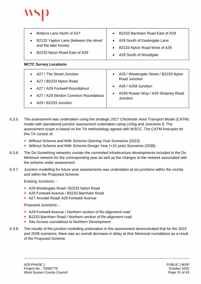
A29 PHASE 1 PUBLIC | WSP Project No.: 70060779 October 2020 West Sussex County Council Page 31 of 43
• Brittens Lane North of A27
• B2132 Yapton Lane (between the street
and the lake house)
• B2233 Nyton Road East of A29
• B2233 Barnham Road East of A29
• A29 South of Eastergate Lane
• B2233 Nyton Road West of A29
• A29 South of Woodgate
MCTC Survey Locations
• A27 / The Street Junction
• A27 / B2233 Nyton Road
• A27 / A29 Fontwell Roundabout
• A27 / A29 Slindon Common Roundabout
• A29 / B2233 Junction
• A29 / Westergate Street / B2233 Nyton
Road Junction
• A29 / A259 Junction
• A259 Rowan Way / A29 Shripney Road
Junction
6.3.5. The assessment was undertaken using the strategic 2017 Chichester Area Transport Model (CATM)
model with operational junction assessment undertaken using LinSig and Junctions 9. The
assessment scope is based on the TA methodology agreed with WSCC. The CATM forecasts for
this TA consist of:
Without Scheme and With Scheme Opening Year Scenarios (2023)
Without Scheme and With Scheme Design Year (+15 year) Scenarios (2038).
6.3.6. The Do Something networks contain the committed infrastructure developments included in the Do
Minimum network for the corresponding year as well as the changes to the network associated with
the scheme under assessment.
6.3.7. Junction modelling for future year assessments was undertaken at six junctions within the vicinity
and within the Proposed Scheme:
Existing Junctions: -
A29 Westergate Road / B2233 Nyton Road
A29 Fontwell Avenue / B2233 Barnham Road
A27 Arundel Road/ A29 Fontwell Avenue
Proposed Junctions: -
A29 Fontwell Avenue / Northern section of Re-alignment road
B2233 Barnham Road / Northern section of Re-alignment road
Site Access roundabout to Northern Development
6.3.8. The results of the junction modelling undertaken in this assessment demonstrated that for the 2023
and 2038 scenarios, there was an overall decrease in delay at War Memorial roundabout as a result
of the Proposed Scheme.

A29 PHASE 1 PUBLIC | WSP Project No.: 70060779 October 2020 West Sussex County Council Page 32 of 43
6.3.9. The junction modelling also showed that the proposed junctions at the northern and southern end of
the Proposed Scheme operate within theoretical capacity in the AM and PM peaks in both the 2023
and 2038 scenarios.
6.3.10. The improved cyclist and pedestrian facilities and shared use path will encourage local residents to
undertake local trips on foot or by bike.
6.3.11. The assessment concludes that the Proposed Scheme would be beneficial to the highway network
in the Westergate area especially at the War Memorial roundabout where existing traffic diverts to
use the Proposed Scheme.
6.3.12. Modelling for both 2023 and 2038 future year assessments show that the Proposed Scheme would
have a minimal or beneficial impact on the assessed junctions. There will be an increase in
southbound traffic at the A29 Westergate Road / B2233 Nyton Road junction. However, it is
anticipated that this will be the reduced when Phase 2 becomes operational.
6.3.13. Overall, it is considered that the Proposed Scheme will form the first phase of a road improvement
scheme which will adequality mitigate the current identified problems with this section of the A29
and provide sufficient capacity to deliver the significant new allocated housing sites on land near
Barnham, Eastergate, Westergate (see Figure 6.2 below) during the ALP period (2011-2031), with
potential on the Site for a further 700 dwellings to be delivered after 2031. It is therefore considered
that the Proposed Scheme will comply with the aforementioned transport related policies in section 5
of the Statement, in particular with:
Strategic aims and objections for Arun as set out in the West Sussex Transport Plan 2011-26;
Policy T SP1 (Transport and Development) which seeks to ensure that development provides
safe access on to the highway network; contributes to highway improvements and promotes
sustainable transport, including the use of cycle and pedestrian network;
Policy T DM1 (Sustainable Travel and Public Rights of Way) which seek to ensure ease of
movement, prioritising safe pedestrian and cycle access; and
Policy T SP3 (Safeguarding the Main Road Network) which seek to ensure that improvements
necessary to enhance the strategic and supporting road network within the District can be carried
out, as shown on the Policies Map.
6.4 DESIGN QUALITY
6.4.1. The proposed highway design is utilitarian – it is based mainly on its need, function and purpose,
rather than on aesthetics. As previously mentioned, the Proposed Scheme will deliver phase 1 of a
two phased comprehensive highway improvement scheme. The ALP identifies Bognor Regis as a
strategic location where new development is expected to help deliver much needed regeneration
during the lifetime of the Plan. The ALP also allocates land at Barnham, Eastergate and Westergate
for strategic housing, as shown in Figure 6.2 below, and commercial development and associated
community infrastructure. The site allocation also includes an indicative route for the Proposed
Scheme to provide access to the site as part of a strategic infrastructure package to mitigate the
cumulative impacts of development over the plan period.
6.4.2. The layout of the Proposed Scheme is primarily dictated by the function of the scheme. Its alignment
is dictated by the indicative line set out as a red dotted line (see Figure 6.2) in the ALP Policies Map
2.

A29 PHASE 1 PUBLIC | WSP Project No.: 70060779 October 2020 West Sussex County Council Page 33 of 43
Figure 6-2 - Allocated Housing Sites in the ALP
6.4.3. The segregation of motorised vehicles and pedestrian and cyclists in the proposed layout (Site
Layout Plan drawing nos. A29-CAP-HPN-00-DR-C-0132 to – 0136 (consec)), in the typical sections
of the proposed new carriageway layout (Cross Sections drawing nos. A29-CAP-HPN-00-DR-C-
0180 to -0182 (consec)) – see Figure 6.3 below, is intended to encourage walking and cycling on
this road due to an increased sense of safety through physical separation of traffic.

A29 PHASE 1 PUBLIC | WSP Project No.: 70060779 October 2020 West Sussex County Council Page 34 of 43
Figure 6-3 - Typical Cross Section Plan
6.4.4. The road has been designed to adoptable standards and therefore is to a scale which is no larger
than is necessary to accommodate the predicted traffic flows.
6.4.5. The design seeks to ensure that it minimises adverse effects on views; adopts an appropriate scale,
layout, and density necessary for efficient operation but is sympathetic to prevailing site and
surrounding characteristics, in accordance with ALP Policies D SP1 (Design) and D DM1 (Aspect of
form and design quality). Where appropriate, the Proposed Scheme incorporates sustainable design
principles such as selecting environmentally friendly building products, and sustainable drainage
design.
6.4.6. A comprehensive landscape scheme forms an integral part of the overall design proposals and are
shown on the Soft Landscape Plan drawing nos. A29-WSP-LA-GA-001 to – 005 (consec). The
proposed landscape scheme meets the criterion contained within ALP Policy LAN DM1 (Protection
of Landscape Character) and BENP Policy ES4 (Protection of open views), through where possible,
protecting existing landscape features, with attention paid to the provision of strategic tree planting
becoming denser in areas around the attenuation ponds and to the creation of linear habitat
features. Proposed shrub and scattered tree planting that line the carriageway will manage the
transition between built form and adjacent fields. The proposed landscaping will visually soften the
impact of the urban road feature. Such landscape design measures lessen the visual impact and will
ensure the proposal is sympathetically assimilated into the surrounding agricultural landscape.
6.4.7. Overall, it is considered that the Proposed Scheme will comply NPPF (Section 12. Achieving well-
designed places); ALP Policies D SP1 (Design), D DM1 (Aspect of form and design quality), and
LAN DM1 (Protection of Landscape Character); and BENP Policy ES4 (Protection of open views).
6.5 ENVIRONMENMTAL CONSIDERATIONS
6.5.1. Notwithstanding the clear demonstrable need for this section of highway infrastructure,
environmental considerations have been examined throughout the preparation of this planning
application. A full suite of environmental surveys have been undertaken as part of the EIA to give a
full assessment of any likely significant effects, to support the design of the proposal. The main
findings of these assessments are summarised below.
A29 PHASE 1 PUBLIC | WSP Project No.: 70060779 October 2020 West Sussex County Council Page 35 of 43
AIR QUALITY AND DUST
6.5.2. Chapter 6 of the ES assesses the likely significant effects arising from the scheme on air quality.
6.5.3. Defra’s PCM model for the study area and the wider WSCC area shows that the baseline air
pollutant levels in 2017 were well below the EU Air Quality Standards (AQS) levels. Similarly, ADC
show that current NO2 levels are significantly below the AQS level of 40µg/m3. Defra’s modelled
future baseline level of air pollutants is lower in 2023 than in 2017, reflecting its forecast reductions
in vehicle emissions.
6.5.4. The assessment concludes that there is likely to be a direct, temporary, short term, moderate
adverse effect on all receptors during the construction phase. There are 136 receptors within 100m
of construction activities with a high sensitivity level. An addition 146 receptors are between 100-
200m from construction activities with a low sensitivity.
6.5.5. The Construction Environmental Management Plan (CEMP) will comprise a range of appropriate
mitigation measures, which may include damping down of dry services, locating stockpiles away
from sensitive receptors, or on-site speed restrictions. The residual effects following the
implementation of these mitigation measures will reduce the identified effects to acceptable levels.
The assessment recommends that mitigation measures are monitored via regular site inspections to
ensure effective implementation.
6.5.6. The assessment also concludes that post construction, concentrations of all pollutants would remain
well below the AQS. The greatest increase would be 1.2µg/m3 at receptors E11 (Green Oaks,
B2233 Barnham Road, Eastergate) and E12 (Chantry Mead, Eastergate) where the concentrations
with the Scheme would be 13.2µg/m3 and 10.5µg/m3 respectively, both well below the AQS level of
40µg/m3.
6.5.7. Therefore, pollutants generated by the Proposed Scheme will be below DEFRA’s predicted air
quality levels, and as such, no further mitigation measures will be required.
6.5.8. The Proposed Scheme is considered to comply with ALP Policies QE SP1 (Quality of the
Environment) and QE DM3 (Air Pollution).
NOISE AND VIBRATION
6.5.9. Chapter 7 of the ES reports on the noise and vibration impacts of the proposed scheme on
residential dwellings and other sensitive receptors.
6.5.10. There are several residential properties that are located immediately adjacent to the area where the
Proposed Scheme will meet the B2233 Barnham Road, notably Murrell Gardens, Ewens Gardens
and Downview Road. There are also residential properties on the A29 Fontwell Avenue, which will
be within close proximity to the north eastern tie-in of the scheme. Dwellings south of Eastergate
Lane are within 300m from the scheme alignment.
6.5.11. The closest Noise Important Area (IA), railway RI 550, is located around Barnham Station just within
1km west of the scheme. Further afield, there are Noise IAs on the A27 over 1km north of the
scheme. These include IA 12491. In addition, IA 12493, located to the south east on the A29, is also
at a distance over 1km from the scheme.
6.5.12. In the construction phase, noise and vibration will have a major, temporary, direct and short-term
impact on residential dwellings. A range of mitigation measures (using Best Practical Means – BPM)
will be implemented, including switching vehicles and plant off when not in use, installing the

A29 PHASE 1 PUBLIC | WSP Project No.: 70060779 October 2020 West Sussex County Council Page 36 of 43
permanent 3m noise barrier at the earliest opportunity, using low vibratory equipment and
methodologies, and locating vibratory plant equipment at least 50m from sensitive receptors.
6.5.13. In regard to the operational phase, the assessment has identified a need for a noise barrier on the
eastern side of the new road alignment and properties on Murrell Gardens. The barrier will be 3m
high, approximately 440m long and comprise of absorptive materials required to reduce noise to
acceptable levels at the properties on Murrell Gardens.
6.5.14. The assessment demonstrates that the Proposed Scheme with mitigation will not have significant
adverse noise effect on the amenity of nearby residents.
6.5.15. The Proposed Scheme is considered to comply with ALP Policies QE SP1 (Quality of the
Environment) and QE DM1 (Noise pollution).
ECOLOGY AND NATURE CONSERVATION
6.5.16. Chapter 9 of the ES reports the outcome of the assessment of likely significant effects arising from
the Proposed Scheme upon Ecology and Nature Conservation.
6.5.17. The ecological baseline status has been established through desk studies and field surveys. A
range of habitats and species were considered in the assessment including:
On and off-site habitats of conservation importance;
Bats;
Badger;
Birds;
Reptiles; and
Invertebrates.
6.5.18. The assessment identified that during the construction and operation phases the likely effects will be
significant on all receptors and therefore, the following mitigation measures are recommended:
The production of a Construction Environmental Management Plan (CEMP) and associated
Ecological Management Plan (EMP) for the construction phase of the Proposed Scheme (refer to
Appendix 3.5 of the ES). The CEMP and EMP will include best practice construction measures to
minimise the effects of noise pollution and visual disturbance to onsite and offsite receptors, as
well as a sensitive programme of works, a sensitive temporary lighting regime and measures for
sensitive vegetation clearance;
The production of a permanent sensitive lighting strategy to reduce effects upon sensitive
habitats and species, to be informed by best practice guidance regarding bats, refer to the
lighting assessment (Appendix 10.2 of the ES); and
Landscaped areas to be managed in line with the Landscape Maintenance and Management
Plan (LMMP) (refer to Appendix 10.4 of the ES) and sensitively with regard to protected species.
Biodiversity Net Gain
6.5.19. A biodiversity net gain assessment of the landscape design prepared for the Proposed Scheme has
been undertaken. The aim was to achieve a biodiversity net gain (BNG) of 10%. The results of the
assessment indicate that whilst the area-based habitats achieve a BNG of +44% the hedgerow units
show a no net loss of +3%. As such, the Proposed Scheme does not achieve a scheme wide BNG.
6.5.20. However, this is due principally to the lack of available land to provide additional planting to achieve
a net gain. The immediate surrounding land has been allocated for housing development and it is

A29 PHASE 1 PUBLIC | WSP Project No.: 70060779 October 2020 West Sussex County Council Page 37 of 43
considered that on balance, the need to achieve a biodiversity net gain is outweighed by the need to
provide additional housing to meet ALC’s housing delivery targets.
LANDSCAPE
6.5.21. A Landscape Character and Visual Assessment has been undertaken to inform the iterative design
process of the Proposed Scheme and assess the likely effects on identified landscape and visual
receptors. Full details of the assessment is found at Chapter 10 of the ES.
6.5.22. The Application Site is located approximately 1.4km to the south of the South Downs National Park
and to the north of the coastal town of Bognor Regis within National Character Area 126 – South
Coast Plain. It is a transitional landscape that mainly comprises arable fields, woodland, hedgerows,
orchard and areas of managed grassland. The Site is also part of numerous local landscape
designations, as set out in WSCC and ALP landscape assessments.
6.5.23. In summary, the assessment concludes that the Proposed Scheme will not impact adversely on any
landscape designations, including the three Landscape Character Areas identified in Table 10-8 of
the EIA, and will not exhibit any rare or unusual landscape features. Construction effects will be
temporary and will be mitigated through the CEMP.
6.5.24. Whilst there would inevitably be some visual impact on the surrounding landscape post operation,
this should be considered against the need for the development, as well as the strategic requirement
for the road to be in the location proposed in order to enable future housing growth. Furthermore,
this should all be considered in the wider context; the Proposed Scheme is not too remote from
settlements and, as designated in the ALP, is within an area of planned change. The Proposed
Scheme will become integrated with future residential development, extending the urban form and
creating a new settlement. Therefore, the visual impact of the Proposed Scheme will lessen over
time.
6.5.25. The design of the Proposed Scheme has included landscape mitigation measures which includes:
New woodland planting to create habitat for wildlife in addition to provide green visual
containment;
New specimen tree planting to enhance visual appeal and integrate the Proposed Scheme into
the surrounding;
New hedgerow planting to enhance visual amenity of the Proposed Scheme and respond
positively to the local character; and
Areas of wildflower grassland and bulb planting to enhance the biodiversity along with visual
appeal.
6.5.26. On balance, it is considered that the need and the benefits that the Proposed Scheme will deliver
outweigh the short-term adverse effects the proposal will have on the landscape character of the
area. The Proposed Scheme will comply with comply with ALP Policy LAN DM1 (Protection of
Landscape Character) and BENP Policy ES4 (Protection of open views).
WATER RESOURCES AND FLOOD RISK
6.5.27. Chapter 11 of the ES reports the outcome of the assessment of likely significant effects arising from
the Proposed Scheme upon water resources, flood risk and drainage.
A29 PHASE 1 PUBLIC | WSP Project No.: 70060779 October 2020 West Sussex County Council Page 38 of 43
6.5.28. There are a number of sensitive surface and ground water resource receptors near to the
Application Site that could be affected by pollution (Barnham Lane Ditch, Barnham Rife, Lidsey Rife
and School Ditch, and Superficial Deposits).
6.5.29. The assessment concludes that the Proposed Scheme has the potential to adversely impact on the
water quality of water resources as a result of construction activities through accidental leaks and
spillages or release of harmful substances caused by materials being stored on site, such as oils,
fuels and other chemicals. It also identified a number of activities which could reduce surface water
quality with respect to physical contaminants. These include:
Site clearance;
Excavations;
Groundwater dewatering;
Localised ground remediation (if required); and
Materials handling, storage, stockpiling, spillage and disposal.
6.5.30. In addition, during periods of heavy rainfall, vehicle movements associated with construction
activities may result in damage to soil structure that may generate increased sedimentation within
surface run-off.
6.5.31. The proposed Scheme will introduce a significant amount of new impermeable areas leading to
increased rates and volumes of surface water runoff which has the potential to increase flood risk
within the vicinity of the Application Site. An analysis of the Environment Agency’s Risk of Flooding
from Surface Water map indicates that the interception of overland flows could result in an increase
in flood risk as the Proposed Scheme crosses existing flow routes. The drainage proposals are
designed to control runoff up to the 100 year event plus 40% increase due to climate change. The
proposed discharge rate into the Barnham Lane Ditch is 1.8l/s which is a significant reduction in
greenfield runoff for up to the 100 year plus 40% climate change event.
6.5.32. The potential increase in flood risk associated with surface water run-off from new impermeable
areas in the proposed Scheme can be managed through the implementation of the drainage design.
Furthermore, the assessment recommends the following pollution control measures:
The use of swales as runoff collection mechanisms and interception mechanisms. Swales are
designed depressions in the ground designed to carry water away to appropriate locations (e.g.
attenuation ponds). Infiltration along the route, for example through grass, can filter suspended
sediments and slow water flow;
The use of infiltration and attenuation ponds for water storage; and
The use of swales or filter drains for conveyance of water away from the road into the ground.
6.5.33. The above mitigation measures have been incorporated into the Proposed Scheme. Following
implementation of these measures. the assessment concludes that the effects on water resources
and flood risk will not be significant. This approach provides adequate storage and improved water
quality in line with current best practice.
6.5.34. It is therefore considered that subject to the implementation of the mitigation measures, which have
been incorporated into the scheme design, the Proposed Scheme will comply with ALP policies W
SP1 (Water), W DM2 (Flood Risk) and W DM3 (Sustainable Urban Drainage Systems).

A29 PHASE 1 PUBLIC | WSP Project No.: 70060779 October 2020 West Sussex County Council Page 39 of 43
GEOLOGY & SOILS
6.5.35. A Preliminary Risk Assessment has been carried out with the results contained in the Contaminated
Land Preliminary Risk Assessment and Chapter 12 of the ES.
6.5.36. At present the majority of the Application Site is undeveloped and is situated in soft landscaped
areas. The southern part of the Application Site is currently occupied by the Fleurie Horticultural
Nursery which has a loose gravel surface and is occupied by several greenhouse buildings and
other smaller ancillary buildings. An electrical substation is present in the north-western area of the
site along Fontwell Avenue adjacent to the existing A29 road.
6.5.37. Historical mapping indicates that the majority of the Site has never been develop. A gravel pit was
excavated in the north-west corner of the Site in 1897 and was subsequently filled in between 1937
and 1939. The Springfield plant nursery was first constructed in 1912 (originally named The Brooks).
By 1974 additional buildings had been built in the plant nursery to resemble the current layout as
well as two tanks. In 2018 a below ground water reservoir was built in the southern part of the plant
nursery. The surrounding area of the Site has a mixed history of residential, agriculture, gravel
extraction and landfilling and commercial use.
6.5.38. The Assessment concludes that there is a low risk to construction workers and end users, buildings
and underground structures, and UXO. There is a risk to controlled waters however this will be
managed through the suggested mitigation measures contained in the FRA and CEMP.
HISTORIC ENVIRONMENT
6.5.39. The relevant polices are NPPF Section 16 - Conserving and enhancing the historic environment;
and ALP Policies HER SP1 (The Historic Environment) and HER DM6 (Sites of Archaeological
Interest).
6.5.40. Chapter 13 of the ES reports the outcome of the assessment of likely effects arising from the
Proposed Scheme upon Archaeology. Assessment of likely effects on above-ground heritage assets
(such as conservation areas and listed buildings) have been scoped out of the ES, and confirmed in
the Scoping Opinion which is found in the ES.
6.5.41. The Application Site does not contain any nationally designated heritage assets, such as World
Heritage Sites, Scheduled Monuments, listed buildings, Registered Battlefields, or registered parks
and gardens. Also, it is not in a conservation area or in an Archaeological Notification Area (ANA).
6.5.42. Buried heritage assets from various periods have been recorded on-site or in the near proximity,
such as a Palaeolithic axe 1.2km to the north-east of the site and Saxo-Norman assets 800m south-
west of the site. A full chronological summary is set out in page 12 of ES Chapter 13.
6.5.43. The assessment concludes that the Proposed Scheme could have a significant impact on prehistoric
and roman remains if present, due to the construction activities such as site preparation, road
construction, excavation for attenuation ponds, services/drainage and possible planting. Therefore, it
is recommended that an archaeological investigation is carried out prior to construction in order to
clarify the nature, survival and significance of any archaeological assets that may be affected. A
draft Written Scheme of Investigation (WSI) for an archaeological trial trench evaluation, and an
Outline Archaeological Mitigation Strategy are attached to the Environmental Statement as
requested by the WSCC Archaeological Advisor. As an alternative to trial trenching a preliminary
site strip, in the form of Strip, Map and Sample may be undertaken under archaeological direction
A29 PHASE 1 PUBLIC | WSP Project No.: 70060779 October 2020 West Sussex County Council Page 40 of 43
during the construction phase. Regardless of the option, a Post-Excavation Assessment Report
would be prepared.
6.5.44. In such circumstances, mitigation normally comprises preservation by record: advancing
understanding of asset significance through targeted archaeological excavation in advance of
development. This might be combined with a watching brief during ground works for remains of
lesser significance. Post-mitigation residual effects are likely to be negligible and not significant on
both prehistoric and Roman remains.
MINERALS
6.5.45. A Minerals Statement has been prepared to accompany the application and is attached at Appendix
B of this Planning Statement. The site is within a Minerals Safeguarding Area for Sharp Sand and
Gravel in the West Sussex Joint Minerals Plan.
6.5.46. The statement concludes that whilst it would be possible to recover sand and gravel deposits to form
an aggregate product, the refinement process is likely to incur significant additional processing costs
due to the high percentage of recorded clay cohesive bands, and this will reduce the economic
viability of recovery and reuse of the resource.
AERODROME SAFEGUARDING
6.5.47. The Site is located approximately 6.7km from Goodwood Aerodrome. The operators of Goodwood
Aerodrome have been consulted on the Proposed Scheme and have confirmed that they have no
objection to Phase 1 of the A29 realignment on aerodrome safeguarding grounds. An Aerodrome
Safeguarding Statement confirming this is attached at Appendix C of this Statement.

A29 PHASE 1 PUBLIC | WSP Project No.: 70060779 October 2020 West Sussex County Council Page 41 of 43
7 CONCLUSION
7.1.1. Planning permission is sought for:
“The construction of a 1.3km single carriageway with a 3m wide shared cycleway / footway, one
uncontrolled pedestrian crossing to enable users of the PRoW to cross the carriageway, three
roundabouts, provision of hard and soft landscaping, road markings, traffic signals, bus stops, and
signalised pedestrian crossings, construction of a substation building; installation of a noise barrier,
and other associated works”
7.1.2. The existing A29 experiences traffic congestion during the peak periods, notably at the Woodgate
level crossing, leading to unreliable journey times and potentially causing poor air quality. The
congestion is caused by the Woodgate level crossing barriers being down resulted in delays of
approximately 35 minutes in the peak hours.
7.1.3. To the north west of the Proposed Scheme is the War Memorial junction. This junction is a critical
pinch point on the existing highway network, with limited scope for capacity improvements due to the
current land constraints surrounding the junction. As such the junction is likely to be a significant
constraint on the level of future development.
7.1.4. To the south of the Proposed Scheme are the Lidsey bends. This is a section along the existing A29
through Lidsey where the alignment requires drivers to negotiate a series of significant bends in the
road which have historically been a source of concern from a road safety perspective.
7.1.5. The strategic site allocations identified in the ALP will generate and affect the distribution of traffic in
the district. The cumulative impacts of the strategic site allocations are expected to increase
demand on the existing A29 and B2233 roads by non-motorised users and motorised vehicles,
including public transport. The Proposed Scheme represents phase 1 of a two phased scheme
which, when completed, will overcome the current traffic issues associated with the existing A29. It
will provide access to planned strategic development at Barnham, Eastergate and Westergate
(shown in Figure 6.2 above) and will help to mitigate impacts on the highway network that would
otherwise be severe. Additionally, there have been recently completed and/or planned commercial
developments north of Bognor Regis at a strategic site known as Enterprise Bognor Regis’ that
could potentially benefit from the A29 Realignment Scheme.
7.1.6. The ALP is supported by an evidence base that includes the Arun District Local Plan Transport
Study 2017 (Local Plan Transport Study). The Local Plan Transport Study identifies a package of
strategic infrastructure to mitigate the severe residual cumulative impacts of development that
includes the A29 Realignment.
7.1.7. To ensure the Proposed Scheme supports the objectives of the WSTP and encourages the use of
sustainable modes of transport and sustainable travel patterns in the strategic development, it has
been designed to cater for non-motorised and motorised users, including public transport. The
design also integrates with the existing highway network and new routes proposed as part of the
strategic development.
7.1.8. The case for the A29 Realignment Scheme of which the Proposed Scheme is a part, is four-fold:
Strategic: The A29 Realignment Scheme is an important part of the WSCC’s strategy to support
growth and development. It will enable the local road network to operate more efficiently by reducing
congestion, improving the predictability of journey times and providing more capacity for growth.

A29 PHASE 1 PUBLIC | WSP Project No.: 70060779 October 2020 West Sussex County Council Page 42 of 43
Economic: The Proposed Scheme will to help build a strong, responsive and competitive economy,
as it will provide infrastructure that will support growth in the local area. Over a 60 year appraisal
period, the value of monetised benefits from journey time savings outweighs the cost of the scheme
by a factor of 1.8 to 1.0. According to the DfT Value for Money categories, this benefit cost ratio
value is considered to be medium. The DfT generally expects major transport schemes seeking
investment to offer at least medium value for money.
The main contributor to the benefits is the average travel time savings resulting from the Proposed
Scheme and the avoidance of Woodgate level crossing and War Memorial Junction. This provides
drivers with improved journey times and a more direct route. There are also potential accident
savings, notably the Lidsey bends. This exceeds the cost of constructing the scheme and its
ongoing maintenance;
Social: The Proposed Scheme will provide infrastructure to support the building of new homes that
will create new, vibrant and healthy communities; and
Environmental: The Proposed Scheme will make effective use of land.
7.1.9. The Consultation process undertaken at the Outline Business Case stage, covering Phase 1 in
combination with Phase 2, generated a number of concerns to the A29 Realignment Scheme. These
included:
Disruption during construction;
Impact on existing residential properties;
Amenity issues - noise, light or air pollution;
Impact on landscape and scenery;
Congestion and journey time;
Road safety; and
Impact on routes used by people walking, cycling and horse riding.
7.1.10. It is acknowledged that there will be some adverse impacts to local residents during the construction
phase, however, these will be short term. Furthermore, the Proposed Scheme will not deliver a
biodiversity net gain, due principally to the lack of available land which has been allocated for
housing development.
7.1.11. However, the disbenefits are considered to be outweighed by the overwhelming public benefits that
the Proposed Scheme will deliver. These include:
Enable delivery of new homes in Arun District supporting delivery of around 11,400 new dwellings
and 104,000sqm of commercial development on permitted or planned development sites in this
part of Arun District;
Improve connections;
Improve and expand the Green Grid to promote strategic east/west and north/south links;
Encourage walking and cycling;
Support delivery of the Strategic Economic Plan and the Local Plan by enabling the delivery of
new homes and jobs; and
Improve journey times on the A29 by avoiding the Woodgate level crossing, Lindsey bends and
the A29/B2233 War Memorial Junction.
Create a sense of place for the strategic allocation;
Enable delivery of new jobs;
Improve road safety;

A29 PHASE 1 PUBLIC | WSP Project No.: 70060779 October 2020 West Sussex County Council Page 43 of 43
Protect the local environment such as improvements to air quality; and
Support sustainable modes of transport.
7.1.12. The overarching conclusions set against the policy context for the Proposed Scheme creates a
compelling case for the approval of this Planning Application. This Planning Statement undertakes
an assessment of the proposals against a series of national and local development plan policies,
with due regard to relevant material considerations. As an overview, it is clear that the Proposed
Scheme complies with the Development Plan considered as a whole, adding to the case for the
positive consideration of this Planning Application.
7.1.13. It is therefore considered that taking the Development Plan as a whole, the Proposed Scheme
complies with the plan, and that the Development Plan and other material considerations point
strongly in favour of the grant of planning permission.

PUBLIC
Mountbatten House
Basing View
Basingstoke, Hampshire
RG21 4HJ
wsp.com